Sinking Deltas due to Human Activities*
|
|
|
- Tamsyn Wilkerson
- 6 years ago
- Views:
Transcription
1 Click to view movies: Locations of U.S. dams. Sea ice concentration. Arctic coastline erosion. Sinking Deltas due to Human Activities* Irina Overeem 1, J. Syvitski, A. Kettner, E. Hutton, and B. Brakenridge Search and Discovery Article #70094 (2010) Posted March 14, 2011 *Adapted from presentation at Tulsa Geological Society, March 1, Editor s note: This presentation is an update/sequel to Search and Discovery Article #50339 (2010) ( Human and Natural Controls on a Delta s Surface Elevation Relative to Local Mean Sea Level by J. Syvitski, A. Kettner, I. Overeem, E. Hutton, M.T. Hannon, and B. Brakenridge). 1 Community Surface Dynamics Modeling System (CSDMS) Integration Facility, INSTAAR, University of Colorado, Boulder CO (irina.overeem@colorado.edu) Abstract Deltas are densely populated, intensively farmed landforms, that are being threatened not just by rising sea levels, but more so by sediment compaction from water, oil and gas mining, sequestration of sediment in upstream reservoirs, and from floodplain engineering. Highresolution topographic data obtained from the 2002 Space Shuttle Radar survey (SRTM), are used to assess a representative suite of 33 major world deltas which have elevations near, at, or below mean local sea level, and for morphodynamic insight on how sediment has historically been deposited. Visible and near-infrared satellite imagery (MODIS Terra and Aqua sensors) are used to assess flooding over , to assess: 1) whether modern deltas are prone to flooding, 2) whether the flooding is from land-derived runoff or ocean surges, and 3) whether the flood waters contain enough suspended sediment to contribute to delta plain aggradation. Historical maps provide evidence on how rivers once flowed through deltas. Many of the deltas have substantive areas below local mean sea level. Of 33 representative world deltas examined, 85% experienced severe flooding in the last decade, temporarily submerging 260,000 km 2, yet only 10% of this flooded area is below sea level. Areas vulnerable to flooding may increase by 50% under projected 21st century eustatic sea level rise, but this is a conservative estimate given the current trends in the reduction in sedimentary deposits that would otherwise buffer deltas. While modern eustatic sea level rise contributes to the problem and often is discussed in the news accelerated compaction, and reduced delta plain aggradation of sediment are of much larger concern for populated deltas. Copyright AAPG. Serial rights given by author. For all other rights contact author directly.
2 Archer, D., 2009, The Long Thaw: Princeton University Press, 179 p. Selected References Gore, A., 2006, An Inconvenient Truth; the planetary emergency of global warming and what we can do about it: Rodale Ammaus, Pennsylvania, 325 p. Hutton E.W.H., and J.P.M. Syvitski, 2008, SedFlux2.0: An advanced process-response model that generates three-dimensional stratigraphy: Computers & Geosciences, v. 34, p Meckel, T.A., U.S. Ten Brink, and S.J. Williams, 2007, Sediment compaction rates and subsidence in deltaic plains: numerical constraints and stratigraphic influences: Basin Research, v. 19/1, p Overeem, I., J.P.M. Syvitski, and E.W.H. Hutton, 2005, Three-dimensional numerical modeling of deltas, in L. Giosan and J.P. Bhattacharya (eds.), River Deltas Concepts, Models, and Examples: Special Publication, Society for Sedimentary Geology, v. 83, p Overeem I. and J.P.M. Syvitski, Dynamics and Vulnerability of Delta Systems: LOICZ Reports and Studies, No 35, GKSS Research Center, Geesthacht, 54 p. Overeem, I. and J.P.M. Syvitski, 2010, Shifting Discharge Peaks in Arctic Rivers, : Geografiska Annaler, Series A, Physical Geography, v. 92/2, p Overeem, I., R. S. Anderson, C. Wobus, G. D. Clow, F. E. Urban, N. Matell, 2011 in revision, Quantifying the role of declining sea ice on the erosion of a permafrost coastline Geophysical Research Letters (GRL). Rogers, K.G. and S.L. Goodbred, Jr., 2010, Mass failures associated with the passage of a large tropical cyclone over the Swatch of No Ground submarine canyon (Bay of Bengal): Geology, v. 38, p Saito, Y., 2008, Coastal characteristics and changes in coastal features, in N. Mimura, (ed.), Asia-Pacific Coasts and Their Management: The states of Environment: Coastal Systems and Continental Margins, v. 11/2, Springer, p Syvitski, J.P.M., A.J. Kettner, I. Overeem, E.W.H. Hutton, M.T. Hannon, G.R. Brakenridge, J. Day, C. Vörösmarty, Y. Saito, L. Giosan, and R.J. Nicholls, 2009, Sinking deltas due to human activities: Nature Geoscience, v. 2/10, p DOI: /NGEO629. Syvitski, J.P.M., C.J. Vörösmarty, A.J. Kettner, and P. Green, 2005, Impact of Humans on the Flux of Terrestrial Sediment to the Global Coastal Ocean: Science 308/5720, p


3 Sinking Deltas due to Human Activities Dr. Irina Overeem, Syvitski, J., Kettner, A., Hutton, E., Brakenridge, B. Community Surface Dynamics Modeling System University of Colorado at Boulder

4 Ganges Delta and Calcutta flooded under sea level rise, from An Inconvenient Truth (2006) Critics: 6m is a sledge hammer estimate And my own delta bias tells me.it is not just a matter of topography!
5 NASA SRTM topography data and numerical modeling Remote-sensing data: NASA Shuttle Radar Topography Mission, world topography data (60 N to 59 S), at 30 m horizontal resolution, ~1 m vertical. MODIS visible band images for daily flood mapping. Numerical Models: HydroTrend, WBM, CEM, SedFlux, AquaTellus (all in the framework of CSDMS). learn more about CSDMS, modeling and free models:

6 Problem: Deltas are low-lying land Mississippi Delta, USA Ganges-Brahmaputra Delta, India & BD Worldwide ~500 million people live in low-lying deltas Thirty-three major deltas combined have >100,000 km 2 at elevation < 2m a.s.l. Thirty-three major deltas combined have >26,000 km 2 at elevation < 0m a.s.l.
7 Controls on Delta Elevation RSL A E C n C A M Δ RSL = Vertical change in delta surface elevation (m/yr) A = Aggradation Rate (m/yr) ΔE = EustaticSea Level Rise (m/yr) Cn = Natural Compaction (m/yr) Ca = Accelerated Compaction (m/yr) M = Crustal Vertical Movement (m/yr) Difficult to isolate terms, derived from tide-gauges Presenter s Notes: Most terms in the equation have spatial variability; aggradation rate is higher in proximity to major distributaries; natural compaction is more rapid in clay/peat; accelerated compaction shows bulls-eyes in zones where mining is most intense. Vertical movement can be localized due to fault distribution.


 Mississippi")
8 RSL A E C n C A M Aggradation is the rate sediment is delivered to and retained on a delta as sediment deposits. Yellow (<150 y) Po (<400 y) Mississippi (<500 y) yrs AD


9 Deltas do flood regularly Cyclone Nargis, Irrawaddy Delta MODIS Terra, May 5th, SRTM 90m topographic data overlay with MODIS flood extend map in red. Floods are widespread, 85% of the studied deltas experienced flooding. From , in the 33 deltas ~260,000 km2 was submerged by floods. Presenter s Notes: Accuweather.com. Cyclone Nargis made landfall with sustained winds of 130 mph and gusts of mph, which is the equivalent of a strong Category 3 or minimal Category 4 hurricane. This is a very large area. 7

10 Aggradation includes sedimentation between distributary channels from overbank flooding Mahanadi R. Brahmani R. Syvitski et al., 2009 MODIS imagery of the Mahanadi and Brahmani Rivers, East India
11 Reduced Aggradation due to Damming Click to view movie Courtesy B.Fekete, C. Vorosmarthy Reduction of sediment delivered to deltas due to damming, modeled with simple retention algorithms (in HydroTrend or WBM)

12 Reduced Aggradation due to Damming Global simulation of BQRT model/wbm with reservoir trapping algorithms. 1.4 ± 0.3 billion tons per year LESS sediment reaches the coast worldwide. 0.4 billion tons per year LESS sediment reaches 33 studied major deltas.
.")
13 Arctic Deltas: Increased Aggradation due to Higher Discharge? , 13%. 17 major Arctic rivers, on average 10% increasing water discharge over last 30 years (Overeem et al., 2010). Presenter s Notes: 17 arctic rivers; most have positive trends

14 Sea Ice Concentration 2008 Beaufort coast North Mackenzie delta Click to view movie Overeem, I et al., in review GRL 2011


15 Sea Ice, Fetch and Wave Model; Beaufort Coast Number of open water days along the Beaufort coast increased from ~45-90 in 30 years. Wave action over the season increased accordingly (Overeem et al., in revision, 2011).
16 Coastal Erosion Click to view movie 15m/year land-loss on permafrost coast
17 Controls on Delta Elevation RSL A E C n C A M Δ RSL = Vertical change in delta surface elevation (m/yr) A = Aggradation Rate (m/yr) ΔE = EustaticSea Level Rise (m/yr) Cn = Natural Compaction (m/yr) Ca = Accelerated Compaction (m/yr) M = Crustal Vertical Movement (m/yr) Difficult to isolate terms, derived from tide-gauges
 RSL = ± A - E - C n -C A ± M Present compaction rates for deposits with thickness of 100m and accumulation time of 10Ky.")
18 Natural Compaction Rates changes in the void space within sedimentary layers (dewatering, grain-packing realignment, organic matter oxidation) RSL = ± A - E - C n -C A ± M Present compaction rates for deposits with thickness of 100m and accumulation time of 10Ky. Meckel et al., 2007

19 Accelerated Compaction due to Subsurface Mining Example: Po delta has greatly been influenced by gas and groundwater mining, Subsidence rates as high as 80mm/yr were observed. Natural compaction ranges between 1-5mm/yr. 70% of the 33 studied deltas experience at least minor groundwater and/or hydrocarbon mining,inducing accelerated compaction.


20 Accelerated Compaction Rates RSL = ± A - E - C n -C A ± M Examples Yangtze: 28 mm/y before controls Niger: 25 to 125 mm/y Chao Phraya: 50 to 150 mm/y Po: 60 mm/y before controls Bangkok s population went from 1M to 12M in 35 years Saito et al., 2008
21 Controls on Delta Elevation RSL A E C n C A M Sea Level Rise Δ RSL = Vertical change in delta surface elevation (m/yr) A = Aggradation Rate (m/yr) ΔE = EustaticSea Level Rise (m/yr) Cn = Natural Compaction (m/yr) Ca = Accelerated Compaction (m/yr) M = Crustal Vertical Movement (m/yr) Difficult to isolate terms, derived from tide-gauges Presenter s Notes: Most terms in the equation have spatial variability, aggradation rate is higher in proximity to major distributaries; natural compaction is more rapid in clay/peat; accelarated compaction shows bulls-eyes in zones where mining is most intense. Vertical movement can be localized due to fault distribution.


22 Relative Sea level Rise in Deltas Global SLR 1.8 mm/yr Relative sea level rose 4 times faster within deltas than globally.
.")
23 Projected Eustatic Sea Level Rise Climate Scenario Temperatur e in C Sea Level Rise in m B A1T B A1B A A1F Projections of sea level rise range between m for Best estimate globally average 0.44m (IPCC, 2007). This estimate does NOT include sinking through reduced aggradation and compaction. Presenter s Notes: IPCC list the scenarios of projected emissions and tabelizes the projected associated temperature changes and sea level rise for as compared to (IPCC 2007).
24 Longterm sea level and temperature (From David Archer, 2009)

25 Relative Rates of Contribution of Land Ice to Eustatic Sea Level Rise for 2025 GT/year GT/year GT/year Low estimate Central estimate High estimate Greenland Glacier/Ice Caps Net Eustatic SLR Rate Equivalents at 2025, based on extrapolation of present day melt rates: W. Antarctica Low estimate Central estimate High Estimate 5.2 mm/yr 8.8 mm/yr 12.4 mm/yr Courtesy Tad Pfeffer, INSTAAR, University of Colorado, unpublished data.

26 Vulnerable Land in Deltas? Vulnerability Threshold 2 m Vulnerability Threshold With GSL ~2.5 m Vulnerability Threshold GSL + Sinking ~2.9m
, Computers and Geosciences.")
27 Coupled HydroTrend Sedflux Model for Ganges Brahmaputra delta INPUT(t) sea level(t), bathymetry (t-0) Q, Qs, Qb (HydroTrend) PROCESSES Details and Equations: Three-dimensional modeling of deltas Overeem et al., SEPM Spec Publ. Hutton, Syvitski ( 2007), Computers and Geosciences. River: avulsion, floodplain SR Marine: delta plume, storms Basin: compaction, subsidence - 3D-geometry - grain size, age OUTPUT (x,z,t)


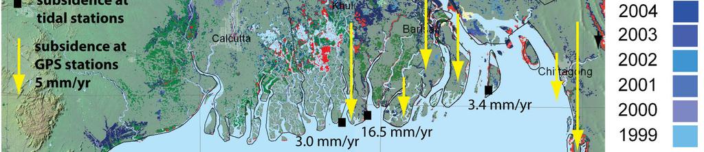
28 Ganges-Brahmaputra Delta: Subsidence and Sea level


29 Coastal Flooding in Deltas Ganges-Brahmaputra Delta, India & BD Ganges-Brahmaputra Delta, MODIS 250m, May 2009 Cyclone Aila, May 2009 Bangladesh. Extensive flooding in Sundabans. Ocean storm set-up was reported ~6-7 m!


 120.")
 2008 Sample Names Average aggradation from sediment traps")
30 Aggradation due to cyclone sedimentation N mass Be7 inventory field stations in Sundarbans Nature Reserve km 1.1.A 1.1.B 1.1.C 1.1.D 1.2.A 1.2.B 1.2.C 1.2.D 1.3.A 1.3.B 1.3.C 1.3.D 2.1.A 2.1.B 2.1.C 2.1.D 2.2.A 2.2.B 2.2.C 2.2.D 2.3.A 2.3.B 2.3.C 2.3.D 3.1.A 3.1.B 3.1.C 3.1.D 3.2.A 3.2.B 3.2.C 3.2.D 3.3.A 3.3.B 3.3.C 3.3.D 4.1.A 4.1.B 4.1.C 4.2.A 4.2.B 4.2.C 4.2.D 4.3.A 4.3.B 4.3.C 4.3.D Mass flux (g/100cm2) Be7 inventory (dpm/cm2) 2008 Sample Names Average aggradation from sediment traps ~11mm over monsoonal cycle. Courtesy K. Rogers,PhD thesis Vanderbilt University

31 SedFlux simulations of rapid sealevel rise for a merging GB system Present-day Monsoon Conditions Sea-level rise 2 m/100 years -10 sea level simulation time distance 80km Presenter s Notes: The two river systems are simulated in one grid here. The Ganges migrates gradually eastward over the grid and merges over the last 100 years with the Brahmaputra that is more confined. The little dots indicate the approximate positions of the hinge point, the dotted lines show the zone wherein the respective rivermouths avulse over time. Even under present-day conditions the two river systems combined still show progadation in this coastal stretch of 80 km.

32 SedFlux simulations of rapid sea-level rise for a merging GB system Present-day Monsoon Conditions Different Subsidence Rates low subsidence 4 mm/year uniformly over entire grid high subsidence 7.5 mm/year locally in graben distance 80 km 0 subsidence in mm/year uniform subsidence graben subsidence distance 80 km Presenter s Notes: System is definitely still dominated by its large flux of incoming sediment


33 Concept: correlated controls Implication: delta system is more resilient to rising sealevel, because it is able to build rapidly. Worst-case scenario! Results in Sinking Deltas
34 Conclusions SRTM data reveals extent and location of delta areas near or below mean sea level. Thirty-three delta systems have > 100,000 km 2 below 2m a.s.l. MODIS imagery from 2001 onwards helps mapping of flooding (either from ocean storms or river floods). 75% of studied deltas experienced flooding in last decade; 260,000 km 2 was temporarily submerged. Deltas are sinking on average 4 times more rapidly than can be explained by eustatic sea level rise alone. We attribute rapid sinking to human interference in river basins and their deltas. 1.Sediment delivery to deltas has greatly been reduced. We model that 3500 billion tons less sediment reaches the deltas per year. 2.Engineering of channels inhibits delivery of sediments to delta floodplain. 3.Compaction due to mining is a major factor in 70% of studied systems. Vulnerable low-lying lands are expanding rapidly. Threshold for vulnerability is farther inland in hurricane / tropical storm-influenced deltas.


35 Acknowledgements & References (1) Overeem I., Syvitski, J.P.M. (eds), Dynamics and Vulnerability of Delta Systems. LOICZ Reports and Studies, No 35. Overeem, I., Syvitski, J.P.M., 2010, Shifting Discharge Peaks in Arctic Rivers, , Geografiska Annaler 92: Overeem, I., R. S. Anderson, C. Wobus, G. D. Clow, F. E. Urban, N. Matell, Quantifying the role of declining sea ice on the erosion of a permafrost coastline (in revision GRL, 2011). These studies were funded by:


36 Acknowledgements & References (2) Syvitski, J.P.M., Kettner, A.J., Overeem, I., Hutton, E.W.H., Hannon, M. T., Brakenridge, G.R., John Day, J. Vörösmarty, C., Saito, Y., Giosan, L., Nicholls, R.J., Sinking Deltas due to Human Activities. Nature Geoscience 2, Syvitski, J.P.M., Vörösmarty, C.J., Kettner, A.J., and Green, P., Impact of Humans on the Flux of Terrestrial Sediment to the Global Coastal Ocean. Science 308: Saito, Y. (2008) Coastal characteristics and changes in coastal features. In Mimura, N. (ed.), Asia-Pacific Coasts and Their Management: The states of Environment. Coastal Systems and Continental Margins, Vol. 11. Springer, pp ( ).
Resilient deltas. Dr. Irina Overeem 1,2)
") Resilient deltas a case-study report on the Volga and Ganges delta systems Dr. Irina Overeem 1,2) 1) CSDMS, INSTAAR, University of Colorado, CO, Boulder, USA 2) Delft University of Technology, The Netherlands
Resilient deltas a case-study report on the Volga and Ganges delta systems Dr. Irina Overeem 1,2) 1) CSDMS, INSTAAR, University of Colorado, CO, Boulder, USA 2) Delft University of Technology, The Netherlands
Sedimentation Patterns in the Ganges- Brahmaputra Delta System
 Sedimentation Patterns in the Ganges- Brahmaputra Delta System SRTM-topography >10 m Irina Overeem, CSDMS, University of Colorado at Boulder K. Rogers, S. Goodbred, S. Higgins, K. Matin, Z. Kahn, S. Cohen,
River and Plume Deposition Ocean Storm Reworking
 River and Plume Deposition Ocean Storm Reworking Irina Overeem Community Surface Dynamics Modeling System University of Colorado at Boulder September 2008 1 Course outline 1 Lectures by Irina Overeem:
Global Population Density
 THE IMPORTANCE OF SCALE IN DEFINING VULNERABILITY OF THE GANGES-BRAHMAPUTRA RIVER DELTA TO ENVIRONMENTAL CHANGE Carol A. Wilson 1, Steven L. Goodbred, Jr. 1, Irina Overeem 2 1 Dept. of Earth and Environmental
Evolution of the Po Delta, Italy
 Evolution of the Po Delta, Italy Albert Kettner & James Syvitski, Charles Vörösmarty Dynamics and Vulnerability of River Delta Systems workshop September, 2007 Outline 21,000 years ago Effects of the ever
Selected Presentation from the INSTAAR Monday Noon Seminar Series.
 Selected Presentation from the INSTAAR Monday Noon Seminar Series. Institute of Arctic and Alpine Research, University of Colorado at Boulder. http://instaar.colorado.edu http://instaar.colorado.edu/other/seminar_mon_presentations
COASTAL VULNERABILITY DUE TO SEA-LEVEL RISE HAZARDS IN THE BANGLADESH DELTA: BAND-AID
 Band-Aid Project NASA NASA ESA ESA JAXA NASA/DLR COASTAL VULNERABILITY DUE TO SEA-LEVEL RISE HAZARDS IN THE BANGLADESH DELTA: BAND-AID R. Rietbroek, B. Uebbing, C.K. Shum, V. Ballu, S. Calmant, J. Duan,
East Asia & Southeast Asia region
 Deltas at Risk Dynamics and vulnerability of river delta system East Asia & Southeast Asia region Yoshiki Saito Geological Survey of Japan Huanghe (Yellow River) Plateau Tibetan Himalayas Old Huanghe (500
3.7 Delta Vulnerability Index (Delta Alliance)
") 3.7 Delta Vulnerability Index (Delta Alliance) Short description of rationale of the indicator (3-5 sentences) Delta vulnerability is a function of physical (fluvial) pressures, (local) state conditions
3.7 Delta Vulnerability Index (Delta Alliance) Short description of rationale of the indicator (3-5 sentences) Delta vulnerability is a function of physical (fluvial) pressures, (local) state conditions
Semi-enclosed seas. Estuaries are only a particular type of semi-enclosed seas which are influenced by tides and rivers
 Semi-enclosed seas Estuaries are only a particular type of semi-enclosed seas which are influenced by tides and rivers Other semi-enclosed seas vary from each other, mostly by topography: Separated from
CLIMATE READY BOSTON. Climate Projections Consensus ADAPTED FROM THE BOSTON RESEARCH ADVISORY GROUP REPORT MAY 2016
 CLIMATE READY BOSTON Sasaki Steering Committee Meeting, March 28 nd, 2016 Climate Projections Consensus ADAPTED FROM THE BOSTON RESEARCH ADVISORY GROUP REPORT MAY 2016 WHAT S IN STORE FOR BOSTON S CLIMATE?
The Coast: Beaches and Shoreline Processes
 1 2 3 4 5 6 7 8 9 The Coast: es and Shoreline Processes Trujillo & Thurman, Chapter 10 Oceanography 101 Chapter Objectives Recognize the various landforms characteristic of beaches and coastal regions.
Climate Change: Understanding Recent Changes in Sea Level and the Ocean. Sea Level Rise
 Climate Change: Understanding Recent Changes in Sea Level and the Ocean Sea Level Rise Philip L. Woodworth Proudman Oceanographic Laboratory, Liverpool ASE/BA/City of Culture Evening 18 October 2007 Long
The Coast: Beaches and Shoreline Processes Trujillo & Thurman, Chapter 10
 The Coast: es and Shoreline Processes Trujillo & Thurman, Chapter 10 Oceanography 101 Chapter Objectives Recognize the various landforms characteristic of beaches and coastal regions. Identify seasonal
MISSISSIPPI RIVER DELTA OVERVIEW
 MISSISSIPPI RIVER DELTA OVERVIEW Science and Engineering Special Team Conference Louisiana State University October 9, 2012 Introduction Basics of the Mississippi Delta Natural and Human-Induced Land Loss
Latitudinal Controls on Siliciclastic Sediment Production and Transport*
 Latitudinal Controls on Siliciclastic Sediment Production and Transport* J. P. Syvitski 1, A. J. Kettner 1, I. Overeem 1, G. R. Brakenridge 1, and S. Cohen 2 Search and Discovery Article #41923 (2016)**
How Will Melting Ice Sheets Affect Us?
 PASSAGE 4 How Will Melting Ice Sheets Affect Us? Variation is normal. During the last ice age, for example, ice sheets also covered much of North America and Scandinavia. Why is what s happening now different
The Science of Sea Level Rise and the Impact of the Gulf Stream
 Old Dominion University ODU Digital Commons July 29, 2016: The Latest in Sea Level Rise Science Hampton Roads Sea Level Rise/Flooding Adaptation Forum 7-29-2016 The Science of Sea Level Rise and the Impact
Optimal Design of Sediment Diversions for Delta Restoration: lessons learned from examples
 Optimal Design of Sediment Diversions for Delta Restoration: lessons learned from examples Samuel Bentley 1, Angelina Freeman 2, Clinton S. Willson 1, Liviu Giosan 3, Jaye Cable 4 1 LSU 2 EDF 3 WHOI 4
Future Sea Level Rise and its Implications for SIDS and LDCs
 Future Sea Level Rise and its Implications for SIDS and LDCs Bill Hare, Michiel Schaeffer, Mahé Perrette, Matthias Mengel COP17, Durban, 2 nd December Overview Part 1: Global sea level: past and future
Sea-level Rise on Cape Cod: How Vulnerable Are We? Rob Thieler U.S. Geological Survey Woods Hole, MA
 Sea-level Rise on Cape Cod: How Vulnerable Are We? Rob Thieler U.S. Geological Survey Woods Hole, MA Outline Sea-level and coastal processes Past sea-level change Predictions for the future Coastal responses
Ice Sheets and Sea Level -- Concerns at the Coast (Teachers Guide)
") Ice Sheets and Sea Level -- Concerns at the Coast (Teachers Guide) Roughly 153 million Americans (~53% of the US population) live in coastal counties. World wide some 3 billion people live within 200 km
Ice Sheets and Sea Level -- Concerns at the Coast (Teachers Guide) Roughly 153 million Americans (~53% of the US population) live in coastal counties. World wide some 3 billion people live within 200 km
Chapter 2. Changes in Sea Level Melting Cryosphere Atmospheric Changes Summary IPCC (2013)
") IPCC (2013) Ice is melting faster (sea ice, glaciers, ice sheets, snow) Sea level is rising More ocean heat content More intense rainfall More severe drought Fewer frosts More heat waves Spring is arriving
IPCC (2013) Ice is melting faster (sea ice, glaciers, ice sheets, snow) Sea level is rising More ocean heat content More intense rainfall More severe drought Fewer frosts More heat waves Spring is arriving
Tony Pratt, DNREC to The Center for the Inland Bays Scientific and Technical Advisory Committee. August 21, 2009
 Sea Level Rise in Delaware Presented by Tony Pratt, DNREC to The Center for the Inland Bays Scientific and Technical Advisory Committee August 21, 2009 Sea level has been fluctuating ever since there have
Coastal Funnels: Upstream and Coastal Land Cover / Land Use Change and Impacts on Highly Urbanized River Delta Systems
 Coastal Funnels: Upstream and Coastal Land Cover / Land Use Change and Impacts on Highly Urbanized River Delta Systems Charles Vörösmarty Zachary Tessler CUNY Environmental CrossRoads Initiative City College
HURRICANE SANDY LIMITED REEVALUATION REPORT UNION BEACH, NEW JERSEY DRAFT ENGINEERING APPENDIX SUB APPENDIX C SEA LEVEL RISE ANALYSIS
 HURRICANE SANDY LIMITED REEVALUATION REPORT UNION BEACH, NEW JERSEY DRAFT ENGINEERING APPENDIX SUB APPENDIX C SEA LEVEL RISE ANALYSIS Rev. 18 Feb 2015 1.0 Introduction 1.1 Guidance The Department of the
FIG Working Week May, Bulgaria From the wisdom of the ages to the challanges of modern world
 FIG Working Week 17-21 May, Bulgaria From the wisdom of the ages to the challanges of modern world COASTAL RISK ANALYSIS OF THE BLACK SEA UNDER THE SEA LEVEL RISE N e v i n B e t u l A V S A R, S e n o
Current Climate Science and Climate Scenarios for Florida
 Current Climate Science and Climate Scenarios for Florida Daniel Bader and Vivien Gornitz Water Utilities and Climate Change Workshop Palm Beach County Water Utilities/ Water Research Foundation June 10,
Comparative Analysis of Hurricane Vulnerability in New Orleans and Baton Rouge. Dr. Marc Levitan LSU Hurricane Center. April 2003
 Comparative Analysis of Hurricane Vulnerability in New Orleans and Baton Rouge Dr. Marc Levitan LSU Hurricane Center April 2003 In order to compare hurricane vulnerability of facilities located in different
LONDON & TE December 2009
 LONDON & TE2100 10 December 2009 Tim Reeder Environment Agency How is London vulnerable to CC? Flooding Overheating Water resources Air Quality Subsidence and heave Wind storms Global climate events What
Altered morphodynamics in tidallyinfluenced rivers: re-thinking catchment management, flood risk & material fluxes
 Altered morphodynamics in tidallyinfluenced rivers: re-thinking catchment management, flood risk & material fluxes Paul A. Brewer, Mark G. Macklin, Marc Huband and Sara Rassner Centre for Catchment and
UNIT 11 SOUTH ASIA SG 1 - PHYSICAL GEOGRAPHY & THE ENVIRONMENT
 UNIT 11 SOUTH ASIA SG 1 - PHYSICAL GEOGRAPHY & THE ENVIRONMENT I. PHYSICAL GEOGRAPHY TAKE OUT YOUR PHYSICAL MAP OF SOUTH ASIA A. The Himalayan Mountains form the northern boundary of the region (color
Should I Sell My Shore House? NJ As a Natural Laboratory for Sea-level Change Ken Miller, Chair of Geological Sciences (FAS)
") Should I Sell My Shore House? NJ As a Natural Laboratory for Sea-level Change Ken Miller, Chair of Geological Sciences (FAS) Hurricane Isabelle, Avalon, NJ 9/18/2003 December Nor easter, LBI, 12/1993 Ash
Should I Sell My Shore House? NJ As a Natural Laboratory for Sea-level Change Ken Miller, Chair of Geological Sciences (FAS) Hurricane Isabelle, Avalon, NJ 9/18/2003 December Nor easter, LBI, 12/1993 Ash
Close to half a billion people live on or near deltas, often in
 Sinking deltas due to human activities progress article Published online: 20 SEPTEMBER 2009 James P. M. Syvitski 1 *, Albert J. Kettner 1, Irina Overeem 1, Eric W. H. Hutton 1, Mark T. Hannon 1, G. Robert
Predicting the Distribution and Properties of Buried Submarine Topography on Continental Shelves
 Predicting the Distribution and Properties of Buried Submarine Topography on Continental Shelves PI: James P.M. Syvitski, INSTAAR, Univ. of Colorado, 1560 30 th St., Boulder CO, 80309-0450 phone: (303)
Regional and global trends
 SEA LEVEL RISE Regional and global trends OCEANOBS 2009 Plenary Paper A.Cazenave D. Chambers, P. Cipollini, J. Hurell, S. Nerem, L.L. Fu, H.P. Plag, C.K. Shum, J. Willis Venice, September 2009 Global mean
Holocene Lower Mississippi River Avulsions: Autogenic Versus Allogenic Forcing*
 Holocene Lower Mississippi River Avulsions: Autogenic Versus Allogenic Forcing* Eric Prokocki 1,2 Search and Discovery Article #50330 (2010) Posted October 14, 2010 *Adapted from oral presentation at AAPG
Toward a Predictive Model of Arctic Coastal Retreat in a Warming Climate, Beaufort Sea, Alaska
 DISTRIBUTION STATEMENT A: Approved for public release; distribution is unlimited. Toward a Predictive Model of Arctic Coastal Retreat in a Warming Climate, Beaufort Sea, Alaska PI: Robert S. Anderson Institute
Sea level change. Eustatic sea level change. Tectono-eustasy. Tectonic control of global sea level. Global signal of sea level change Causes:
 Sea level change Important processes Global vs. local Geologic Modern Current rates of rise Observations, calculations, and models Lessons from the past Projected future changes Eustatic sea level change
Future Climate and Sea Level
 Future Climate and Sea Level Tonight: 2 nd night on human changes and controversy around them. three night series : 1) An Inconvenient truth 2) Impacts: Observed Warming and Projected Sea Level Changes
Mapping of Future Coastal Hazards. for Southern California. January 7th, David Revell, Ph.D. E.
 Mapping of Future Coastal Hazards for Southern California January 7th, 2014 David Revell, Ph.D. drevell@esassoc.com E. Vandebroek, 2012 Outline Coastal erosion hazard zones Flood hazard zones: Coastal
Modeling The Effects Sea Level Rise On Flooding In The Lower Niger River
 City University of New York (CUNY) CUNY Academic Works International Conference on Hydroinformatics 8-1-2014 Modeling The Effects Sea Level Rise On Flooding In The Lower Niger River Zahrah Naankwat Musa
Foundations of Earth Science, 6e Lutgens, Tarbuck, & Tasa
 Foundations of Earth Science, 6e Lutgens, Tarbuck, & Tasa Oceans: The Last Frontier Foundations, 6e - Chapter 9 Stan Hatfield Southwestern Illinois College The vast world ocean Earth is often referred
Coastal Vulnerability Assessment in Semarang City, Indonesia Based on Sea Level Rise and Land Subsidence Scenarios
 Coastal Vulnerability Assessment in Semarang City, Indonesia Based on Sea Level Rise and Land Subsidence Scenarios I. M. Radjawane, D. Hartadi and W. R. Lusano Oceanography Research Division Fac. of Earth
Changing Arctic: climate, environment, metocean conditions, with a special focus on sea ice
 Changing Arctic: climate, environment, metocean conditions, with a special focus on sea ice (IPCC AR4, WG II, Ch.15) Julienne Stroeve National Snow and Ice Data Center (NSIDC), Cooperative Institute for
Sea-Level Rise for the Coasts of California, Oregon, and Washington: Past, Present, and Future
 Sea-Level Rise for the Coasts of California, Oregon, and Washington: Past, Present, and Future Robert A. Dalrymple Committee Chair and Johns Hopkins University June 20, 2012 Global sea level is rising
Earth / Environmental Science. Ch. 14 THE OCEAN FLOOR
 Earth / Environmental Science Ch. 14 THE OCEAN FLOOR The Blue Planet Nearly 70% of the Earth s surface is covered by the global ocean It was not until the 1800s that the ocean became an important focus
A process-based approach toward assessing the coastal impact of projected sea level rise and severe storms
 A process-based approach toward assessing the coastal impact of projected sea level rise and severe storms Patrick Barnard 1, Cheryl Hapke 2, Li Erikson 1, Amy Foxgrover 1, and Maarten van Ormondt 3 1
Oceans and Climate. Caroline Katsman. KNMI Global Climate Division
 Oceans and Climate Caroline Katsman KNMI Global Climate Division Aimée Slangen, Roderik van de Wal (IMAU, Utrecht University) Sybren Drijfhout, Wilco Hazeleger (KNMI, Global Climate) Bert Vermeersen (NIOZ/Delft
Modelling coastal flood risk in the data poor Bay of Bengal region
 Modelling coastal flood risk in the data poor Bay of Bengal region Matt Lewis*, Kevin Horsburgh (NOC), Paul Bates (Bristol) *m.j.lewis@bangor.ac.uk Funded by the EPSRC Flood Risk Management Research Consortium
The Field Research Facility, Duck, NC Warming Ocean Observations and Forecast of Effects
 The Field Research Facility, Duck, NC Warming Ocean Observations and Forecast of Effects A potential consequence of a warming ocean is more frequent and more intense wind events (Hurricanes & Typhoons)
Coastal Storms of the New Jersey Shore
 Coastal Storms of the New Jersey Shore Dr. Steven G. Decker Dept. of Environmental Sciences School of Environmental and Biological Sciences Rutgers University May 25, 2011 Overview Threats Historical Examples
Future Climate Change
 Future Climate Change How do you know whether to trust a prediction about the future? All predictions are based on global circulation models (GCMs, AOGCMs) - model accuracy is verified by its ability to
EFFECTIVE TROPICAL CYCLONE WARNING IN BANGLADESH
 Country Report of Bangladesh On EFFECTIVE TROPICAL CYCLONE WARNING IN BANGLADESH Presented At JMA/WMO WORKSHOP ON EFFECTIVE TROPICAL CYCLONE WARNING IN SOUTHEAST ASIA Tokyo, Japan,11-14 March 2014 By Sayeed
6. What has been the most effective erosive agent in the climate system? a. Water b. Ice c. Wind
 Multiple Choice. 1. Heinrich Events a. Show increased abundance of warm-water species of planktic foraminifera b. Show greater intensity since the last deglaciation c. Show increased accumulation of ice-rafted
Earth Science and Climate Change
 Earth Science and Climate Change Dr. Mary L. Cleave February 7, 2007 YOU ARE HERE 3 Land Use Changes Over Time Lingering Doubts on Temperature Trends Have Been Resolved 1st CCSP Synthesis & Assessment
Field Research Facility
 Field Research Facility Sea Level Rise Observations of Sea Level rise Forces driving change Predicting future Sea Level rise Response of land surface Storm inundation coupled with Sea Level Dr. Jesse McNinch
GLOBAL WARMING: GLOBAL WARMING. landscape implications. Andrew Goudie St Cross College Oxford
 GLOBAL WARMING: GLOBAL WARMING landscape implications Andrew Goudie St Cross College Oxford THE PROCESS OF CHANGE HAS STARTED IPCC 2007 Increased Glacier retreat since the early 1990s Area of seasonally
Rising Sea Levels: Time for Proactive Action in Florida and the Caribbean?
 Rising Sea Levels: Time for Proactive Action in Florida and the Caribbean? Dr. Alan Fyall and Dr. Thomas Wahl National Center for Integrated Coastal Research, University of Central Florida Dr. Roberta
Floods Lecture #21 20
 Floods 20 Lecture #21 What Is a Flood? Def: high discharge event along a river! Due to heavy rain or snow-melt During a flood, a river:! Erodes channel o Deeper & wider! Overflows channel o Deposits sediment
Coastal Evolution in Sedimentary Areas in Greenland
 Coastal Evolution in Sedimentary Areas in Greenland Mette Bendixen P h D s t u d e n t DANCORE Young Professionals Day Dias 1 Outline Motivation State of the art on Arctic coasts Purpose of my Phd Presentation
European Geosciences Union General Assembly Vienna, Austria 27 April - 02 May 2014
 European Geosciences Union General Assembly Vienna, Austria 27 April - 02 May 2014 Projecting the Current & Future Impact of Storm Surges on Coastal Flood Extent at Pigeon Point, South-West Tobago, through
Continental-margin response to sea level: Theory and Experiment
 Continental-margin response to sea level: Theory and Experiment John B. Swenson Department of Geological Sciences and Large Lakes Observatory, University of Minnesota Duluth Chris Paola, Wonsuck Kim, Ben
Regionalizing Sea-level Rise Projections for Urban Planning
 Regionalizing Sea-level Rise Projections for Urban Planning Bob Kopp Rutgers University E-mail: robert.kopp@rutgers.edu Collaborators: Ken Miller, Ben Horton, Jim Browning, Vladimir Pavlovic (Rutgers);
Assessing the local impacts of sea level rise
 Assessing the local impacts of sea level rise Ian Miller, Coastal Hazards Specialist Washington Sea Grant MRC Conference Port Townsend, WA 5 December 2014 With contributions from: Eric Grossman, USGS;
Scenarios for the NI coast in the 21 st Century
 Scenarios for the NI coast in the 21 st Century Prof Julian Orford Geography, Archaeology & Palaeoecology Queen s University, Belfast Challenging perspective Living by the coast is good for your health!
The known requirements for Arctic climate services
 The known requirements for Arctic climate services based on findings described in STT White paper 8/2015 Johanna Ekman / EC PHORS STT Regional drivers The Arctic region is home to almost four million people
A Tutorial on Climate Change Science: The. 4 th National Climate Assessment CLIMATE SCIENCE. Don Wuebbles
 CLIMATE SCIENCE S P E C I A L R E P O R T A Tutorial on Climate Change Science: The Fourth National Climate Assessment Volume I 4 th National Climate Assessment Don Wuebbles Department of Atmospheric Sciences
5. MANY COASTAL COMMUNITIES AND FACILITIES WILL FACE INCREASING EXPOSURE TO STORMS.
 5. MANY COASTAL COMMUNITIES AND FACILITIES WILL FACE INCREASING EXPOSURE TO STORMS. Climate change is altering the Arctic coastline and much greater changes are projected for the future as a result of
What is Climate? Climate Change Evidence & Causes. Is the Climate Changing? Is the Climate Changing? Is the Climate Changing? Is the Climate Changing?
 What is Climate? 1 Climate Change Evidence & Causes Refers to the average environmental conditions (i.e. temperature, precipitation, extreme events) in a given location over many years Climate is what
Climate change, vulnerability and the coasts. Sifting the evidence sea level rise
 CSE s Regional Media Briefing Workshop on Coasts, Coastal Populations and their Concerns Goa, August 13-14, 2010 Climate change, vulnerability and the coasts Sifting the evidence sea level rise Satheesh
Sea level rise and coastal morphological changes on tropical islands New Caledonia and French Polynesia (South Pacific)
") Manuel Garcin, Marissa Yates, Goneri Le Cozannet, Patrice Walker, Vincent Donato Sea level rise and coastal morphological changes on tropical islands New Caledonia and French Polynesia (South Pacific)
Manuel Garcin, Marissa Yates, Goneri Le Cozannet, Patrice Walker, Vincent Donato Sea level rise and coastal morphological changes on tropical islands New Caledonia and French Polynesia (South Pacific)
The AIR Tropical Cyclone Model for India
 The AIR Tropical Cyclone Model for India Tropical cyclones have caused millions, and even billions, of dollars in damage in India. The growing number of properties on the coast, together with growing insurance
P2.57 Cyclone Yasi Storm Surge in Australia Implications for Catastrophe Modeling
 P2.57 Cyclone Yasi Storm Surge in Australia Implications for Catastrophe Modeling Kevin A. Hill*, Peter Sousounis, and Jason Butke AIR Worldwide Corporation, Boston, Massachusetts 1. INTRODUCTION Storm
Geol 117 Lecture 18 Beaches & Coastlines. I. Types of Coastlines A. Definition:
 I. Types of Coastlines A. Definition: 1. Shore = narrow zone where ocean meets land (e.g. beach) 2. Coast is a broad area where both ocean and land processes act a. Includes onshore marshes, dunes, sea
Exam II: Water, Winds, Deserts, Oceans
 Montclair State University, College of Science and Mathematics Department of Earth and Environmental Studies EAES101 Planet Earth Semester: SAMPLE Dr. Mark Chopping Exam II: Water, Winds, Deserts, Oceans
Observed Climate Variability and Change: Evidence and Issues Related to Uncertainty
 Observed Climate Variability and Change: Evidence and Issues Related to Uncertainty David R. Easterling National Climatic Data Center Asheville, North Carolina Overview Some examples of observed climate
Kimberly J. Mueller Risk Management Solutions, Newark, CA. Dr. Auguste Boissonade Risk Management Solutions, Newark, CA
 1.3 The Utility of Surface Roughness Datasets in the Modeling of United States Hurricane Property Losses Kimberly J. Mueller Risk Management Solutions, Newark, CA Dr. Auguste Boissonade Risk Management
Glaciers and climate change Jon Ove Hagen, Department of Geosciences University of Oslo
 Glaciers and climate change Jon Ove Hagen, Department of Geosciences University of Oslo joh@geo.uio.no Department of geosciences, Faculty of Mathematics and Natural Sciences Glaciers and climate change
Hurricanes. Cause: a low pressure storm system over warm ocean water. Effect: potential massive widespread destruction and flooding.
 Hurricanes Hurricanes Cause: a low pressure storm system over warm ocean water. Effect: potential massive widespread destruction and flooding. Hurricanes also known as: cyclone (Indian Ocean) or typhoon
Global Climate Change and Human Health Cycloning out of Control: Climate Change Impacts on Natural Disasters; Cyclones
 INSTRUCTOR BACKGROUND Cyclones are one of the world s most devastating natural disasters causing billions of dollars in damages to homes, building and infrastructure annually. The United Nations estimates
GEOL 1121 Earth Processes and Environments
 GEOL 1121 Earth Processes and Environments Wondwosen Seyoum Department of Geology University of Georgia e-mail: seyoum@uga.edu G/G Bldg., Rm. No. 122 Seyoum, 2015 Chapter 6 Streams and Flooding Seyoum,
What is the IPCC? Intergovernmental Panel on Climate Change
 IPCC WG1 FAQ What is the IPCC? Intergovernmental Panel on Climate Change The IPCC is a scientific intergovernmental body set up by the World Meteorological Organization (WMO) and by the United Nations
Sea level projections with semiempirical and earth system models
 Sea level projections with semiempirical and earth system models John C. Moore College of Global Change and Earth System Science, Beijing Normal University, Beijing, China and Arctic Centre, University
A geological perspective on sea-level rise and its impacts
 A geological perspective on sea-level rise and its impacts K.G. Miller, R.E. Kopp, B.H. Horton, J.V. Browning, A.C. Kemp Front Pages November 1, 2012 kgm@rutgers.edu Ship Bottom, Long Beach Island, NJ
The rate and fate of coastal carbon burial
 The rate and fate of coastal carbon burial Matthew L. Kirwan, Virginia Institute of Marine Science Main Points Marsh size Marsh accretion 1. SLR drives wetland carbon burial in vertical and lateral dimensions
Important Note: The current 2004 SCOS will continue to be the operational standards in the and school years
 This document is designed to help North Carolina educators teach the s (Standard Course of Study). NCDPI staff are continually updating and improving these tools to better serve teachers. Earth/Environmental
ESTIMATING SNOWMELT CONTRIBUTION FROM THE GANGOTRI GLACIER CATCHMENT INTO THE BHAGIRATHI RIVER, INDIA ABSTRACT INTRODUCTION
 ESTIMATING SNOWMELT CONTRIBUTION FROM THE GANGOTRI GLACIER CATCHMENT INTO THE BHAGIRATHI RIVER, INDIA Rodney M. Chai 1, Leigh A. Stearns 2, C. J. van der Veen 1 ABSTRACT The Bhagirathi River emerges from
CLIMATE CHANGE AND REGIONAL HYDROLOGY ACROSS THE NORTHEAST US: Evidence of Changes, Model Projections, and Remote Sensing Approaches
 CLIMATE CHANGE AND REGIONAL HYDROLOGY ACROSS THE NORTHEAST US: Evidence of Changes, Model Projections, and Remote Sensing Approaches Michael A. Rawlins Dept of Geosciences University of Massachusetts OUTLINE
UGRC 144 Science and Technology in Our Lives/Geohazards
 UGRC 144 Science and Technology in Our Lives/Geohazards Flood and Flood Hazards Dr. Patrick Asamoah Sakyi Department of Earth Science, UG, Legon College of Education School of Continuing and Distance Education
Predicting the Distribution and Properties of Buried Submarine Topography on Continental Shelves
 Predicting the Distribution and Properties of Buried Submarine Topography on Continental Shelves PI: James P.M. Syvitski, INSTAAR, Univ. of Colorado, 1560 30 th St., Boulder CO, 80309-0450 phone: (303)
Decoupling Allogenic Forcing from Autogenic Processes: Experimental Stratigraphy. Wonsuck Kim
 Decoupling Allogenic Forcing from Autogenic Processes: Experimental Stratigraphy Wonsuck Kim Department of Geological Sciences and Institute for Geophysics, Jackson School of Geosciences, University of
Vulnerability of Bangladesh to Cyclones in a Changing Climate
 Vulnerability of Bangladesh to Cyclones in a Changing Climate Susmita Dasgupta Kiran Pandey Mainul Huq Zahirul Huq Khan M.M. Zahid Ahmed Nandan Mukherjee Malik Fida Khan 2010 Bangladesh: Tropical Cyclone
An analysis of storm surge attenuation by wetlands using USGS, FEMA, and NASA data
 An analysis of storm surge attenuation by wetlands using USGS, FEMA, and NASA data Pat Fitzpatrick Geosystems Research Institute Mississippi State University Walter Peterson and Courtney Buckley NASA Marshall
WP4: COASTAL PROCESSES
 WP4: COASTAL PROCESSES Coordinator: G. EBERHARDS Faculty of Geography and Earth Sciences, University of Latvia Daugavpils, 2008 Goal: The objective of this study is analysis of coastal changes and forecast
Chapter 9 Lecture Outline. Oceans: The Last Frontier
 Chapter 9 Lecture Outline Oceans: The Last Frontier The Vast World Ocean Earth is referred to as the blue planet 71% of Earth s surface is oceans and marginal seas Continents and islands comprise the remaining
Town of Old Orchard Beach: A summary of sea level rise science, storm surge, and some highlighted results from SLAWG work efforts
 Town of Old Orchard Beach: A summary of sea level rise science, storm surge, and some highlighted results from SLAWG work efforts October 15, 2013 Peter A. Slovinsky, Marine Geologist Maine Geological
ASSESSING FUTURE EXPOSURE: GLOBAL AND REGIONAL SEA LEVEL RISE SCENARIOS FOR THE UNITED STATES
 ASSESSING FUTURE EXPOSURE: GLOBAL AND REGIONAL SEA LEVEL RISE SCENARIOS FOR THE UNITED STATES Chesapeake Bay Program Climate Resiliency Workgroup Conference Call May 15, 2017 William Sweet NOAA CO-OPS
Global Ocean Heat Content (0-700m) Other signs of (global) warming. Global Sea Level Rise. Change in upper ocean temperature ( )
 Other signs of (global) warming. Global Sea Level Rise. Change in upper ocean temperature ( )") Global Ocean Heat Content (0-700m) Change in upper ocean temperature (1955-2003) 0.25C 0.50C Solid lines are three independent estimates (95% confidence interval in grey) IPCC 2007 Fig TS.16 Trends in
Global Ocean Heat Content (0-700m) Change in upper ocean temperature (1955-2003) 0.25C 0.50C Solid lines are three independent estimates (95% confidence interval in grey) IPCC 2007 Fig TS.16 Trends in
Session: For more information:
 Session: For more information: www.hydropower.org/congress Sediment management: mitigation options? Marc Goichot World Hydropower Congress Beijing, China 21 May 2015 A project jointly implemented by MRCS