East Asia & Southeast Asia region
|
|
|
- Conrad Davis
- 5 years ago
- Views:
Transcription
1 Deltas at Risk Dynamics and vulnerability of river delta system East Asia & Southeast Asia region Yoshiki Saito Geological Survey of Japan
 Changjiang (Yangtze River) Ayeyarwady (Irrawaddy)")
 Mekong River Zhujiang (Pearl")
2 Huanghe (Yellow River) Plateau Tibetan Himalayas Old Huanghe (500 MT/y) Changjiang (Yangtze River) Ayeyarwady (Irrawaddy) River Chao Phraya Woodroffe et al., 2006 Song Hong (Red River) Mekong River Zhujiang (Pearl River) >40km2/y New land shrinking


3 Holocene 10 superlobes Saito et al Yellow River Delta Since 1855

4 More than 200 kg/m3 During floods Deforestation in the Loess Plateau Ren and Shi. 1986

5 Wang et al., 2007
6
7 Sediment discharge at Lijin station Big dams Sanmenxia km3/y Liujiaxia Longyangxia Xiaolangdi Bt/y Wang et al., 2007

8 Wang et al., 2007

9 Chu et al., 2006
10 Satellite image analysis: Chu et al., 2006

11 Yang et al. in prep


12 Boundary depth:11-14 m Wang et al.,2006

13 Changjiang (Yangtze delta),, drilling core locations & sea-bottom sediment Maximum shoreline The delta has prograded more than 250 km during the last 6000 years (= ca. 40m/yr)

14 YELLOW RIVER & YANGTZE DELTAS Saito et al., 2001, Geomorphology

15 Yangtze sediment discharge 480 MT/y to ca. 150 MT/y Pristine: MT/y before 2ka Yichang Luoshan Hankou water sediment Yang et al. 2006, WRR


16 Yangtze delta Yang SL et al. GRL 2006

17 Hanoi Red River Delta

18 SONG HONG (RED RIVER) DELTA EVOLUTION, VIETNAM Tide-dominated Fluvial-dominated wavedominated Beach ridges Mathers et al., 1996
19 Sediment discharge of the Red River : 114 MT/y : 79 MT/y : 51 MT/y Hoa Binh dam (1989) Main channel: 49 MT/y in 1949 to 11 MT/y in 2000 Pristine: 20 MT/y before 3-5 ka More than 100 km progradation for the last 6 ky Thanh et al., 2004 Van Maren, 2004 Saito et al., 2007 Tanabe et al., 2006
20 coastal erosion Thanh et al. 2004


21 Catchment area: 795,000 km 2 Main stream length: 4,800 km Mean flow: 14,500 m 3 /s Run off: 575 mm Delta area: 62,520 km2 Mean tidal range: 2.5 m Mean wave height: 0.9 m Water discharge: 470 km3/y Sediment discharge: 160 million t/y

22 Mekong Delta Sediment reduction ~5 % Sand mining :Unknown Tra Vinh More than 250 km Progradation For 6 ky Camau

23 Shoreline changes in Tra Vinh area km Progradation: Deposition Retreat: Erosion NGUYEN Van Lap et al., 2006


24 Shrimp pond NGUYEN Van Lap et al., 2006


25 NGUYEN Van Lap et al., 2006
26 Area of mangrove forest in Tra Vinh coast (ha) ,000 16,300 12,400 5,924 3,725 1,384 6,218 23,700 (2,370 ha/y) 6,500 4,830 (650 ha/y) 2,400 (530 ha/y) (480 ha/y) NGUYEN Van Lap et al., 2006


27 Land use map in Ca Mau cap in 2003 Shrimp farm Mangrove forest Shrimp farm- forest Forest - shrimp farm Mangrove forest Mangrove forest NGUYEN Van Lap et al., 2006
28 Chao Phraya Delta Bangkok

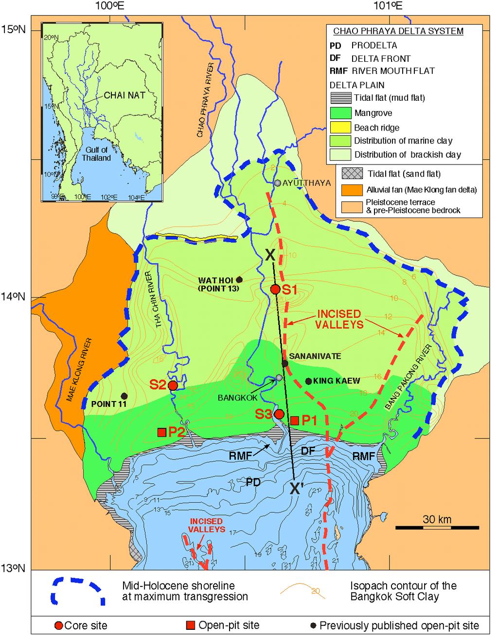
29 Thai cross section
30 1 km shoreline retreat at the river mouth of the Chao Phraya Rokugawa et al., 2006; Saito et al., 2007

31 Chao Phraya delta
32 Marine Inundation
33 Sediment discharge of the Chao Phraya River 15 Mt/y 5 Mt/y Winterwerp et al., 2005

34 Upper Gulf of Thailand During , accretion: 8.9 km 2, erosion: 4.5 km 2 net accretion rate: 0.62 km 2 /y; During , accretion 4.9 km 2, erosion 10.3 km 2, net accretion rate: 0.49 km 2 /y During , accretion 7.4 km 2, erosion 4.5 km 2, net accretion rate 0.25 km 2 /y Saito et al., 2007
35 Relative sea-level rise due to subsidence Land subsidence ca Bangkok 60 cm rise in SL Gulf of Thailand Haq, 1994
 More than 1m Sea-level rise For the last 50 y Winterwerp et al.")
36 Land subsidence During >20 cm/ 8 years cm/y: coast (<4.5 cm/y inland) More than 1m Sea-level rise For the last 50 y Winterwerp et al., 2005

")
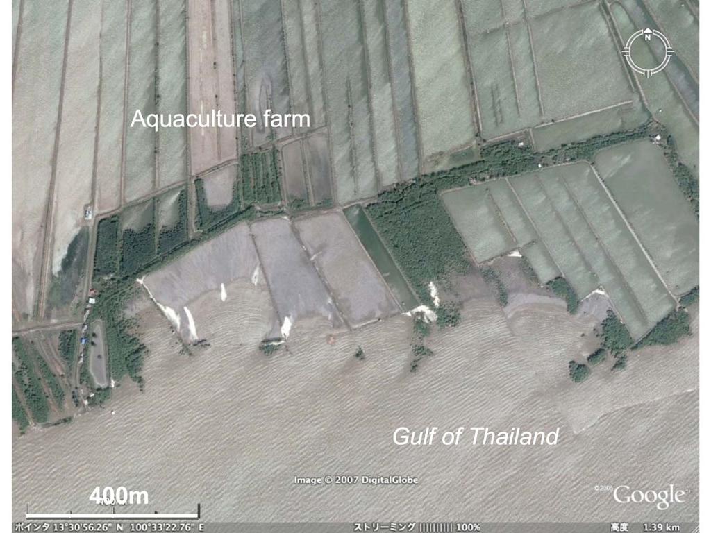
37 Rapid sediment deposition in the intertidal zone (~50 cm thick sediment deposition during 1 m sea-level rise) Saito et al., 2007
38 20 km wide Mean tidal range 1.2 m 2.5 m Upper ITZ Lower ITZ 1 m subsidence 2.5 m
39 20 km wide Mean tidal range 1.2 m 2.5 m 1 m subsidence 1km retreat 2.5 m 50 cm deposition Mangroves play an important role in coastal protection.


40 Chao Phraya Delta Bangkok

41 Zhujiang (Pearl River) The Zhujiang shows a similar reduction of sediment delivery. The annual sediment discharge from the Zhujiang has declined from 80 Mt to 54 Mt on average since As a result of the steady decline since the early 1990s, in 2004 the annual sediment discharge was about one-third the mean pre- 1990s discharge (Zhang et al., 2007).
")


: 1")
42 Pearl River (Zhujiang) example Luo et al., 2007 >8.7x10⁸ m3 sand/22 years >4 x 10⁷ m3 sand/year 8 x 10⁷ t/y (ss): 1 x 10⁷ m3 sand

43 Luo et al.,2007

44 Invitation to IGCP-475: Deltas in the Monsoon Asia-Pacific region International Conference on Deltas (Bangladesh): Deltaic gateways: Linking Source to Sink Dates: January 6-13, 2008 Host: Geological Survey of Bangladesh USD 600 including registration fee, accommodation, meals and two excursions Deadline: October 15, 2007 Search at web IGCP475, Asian Delta
45 Shanghai subsidence
Current Status of Vietnam Coastal Erosion and Major Measures for Mitigation
 Vietnam Administration of Sea and Islands Center for Oceanography University of Transport and Communications Current Status of Vietnam Coastal Erosion and Major Measures for Mitigation Case Study: Thanh
Vietnam Coastal Erosion - Cause and Challenges -
 Administration of Sea and Islands Center for Oceanography University of Transport and Communications, Hanoi Vietnam Vietnam Coastal Erosion - Cause and Challenges - Presenters: Pham Hoang KIEN Le Van CONG
Session: For more information:
 Session: For more information: www.hydropower.org/congress Sediment management: mitigation options? Marc Goichot World Hydropower Congress Beijing, China 21 May 2015 A project jointly implemented by MRCS
Final report for APN project CMY
 Asia Pacific Network for Global Change Research The Mega-Deltas of Asia: A Conceptual Model and its Application to Future Delta Vulnerability Final report for APN project 2004-06-CMY PI: Prof. Zhongyuan
MISSISSIPPI RIVER DELTA OVERVIEW
 MISSISSIPPI RIVER DELTA OVERVIEW Science and Engineering Special Team Conference Louisiana State University October 9, 2012 Introduction Basics of the Mississippi Delta Natural and Human-Induced Land Loss
Sedimentation Patterns in the Ganges- Brahmaputra Delta System
 Sedimentation Patterns in the Ganges- Brahmaputra Delta System SRTM-topography >10 m Irina Overeem, CSDMS, University of Colorado at Boulder K. Rogers, S. Goodbred, S. Higgins, K. Matin, Z. Kahn, S. Cohen,
Assessing the vulnerability of Asian megadeltas to climate change using GIS
 University of Wollongong Research Online Faculty of Science - Papers (Archive) Faculty of Science, Medicine and Health 2010 Assessing the vulnerability of Asian megadeltas to climate change using GIS Colin
From micro to macro scale the impact on the sediment discharge after construction of the Three Gorges Dam on Yangtze River (Changjiang)
") From micro to macro scale the impact on the sediment discharge after construction of the Three Gorges Dam on Yangtze River (Changjiang) Aleksandra Dewiszek 9th International SedNet conference Solving societal
From micro to macro scale the impact on the sediment discharge after construction of the Three Gorges Dam on Yangtze River (Changjiang) Aleksandra Dewiszek 9th International SedNet conference Solving societal
FOR COASTAL AND SHORELINE ECOSYSTEMS. Mohamed Shawal
 CLIMATE CHANGE ADAPTATION FOR COASTAL AND SHORELINE ECOSYSTEMS MLokmanHusain M.Lokman Husain Aidy @ Mohamed Shawal 1 What is global warming? Increases in global average temperature, translating into regional
Sea-level Rise on Cape Cod: How Vulnerable Are We? Rob Thieler U.S. Geological Survey Woods Hole, MA
 Sea-level Rise on Cape Cod: How Vulnerable Are We? Rob Thieler U.S. Geological Survey Woods Hole, MA Outline Sea-level and coastal processes Past sea-level change Predictions for the future Coastal responses
Joint International Conference and First Annual Meeting of IGCP-475 DeltaMAP and APN Project on the Mega-Deltas of Asia
 Joint International Conference and First Annual Meeting of IGCP-475 DeltaMAP and APN Project on the Mega-Deltas of Asia January 15 20, 2004 Bangkok and Ayutthaya, Thailand Call for Abstracts Registration
Mangrove Erosion in the Mekong delta
 Mangrove Erosion in the Mekong delta 1. Introduction a. Mangrove coast - a balance between different forcing factors Mangroves are coastal environments frequently observed in the tropical muddy coasts.
and the Myanmar economy World Water Day, 2018
 and the Myanmar economy World Water Day, 2018 Hannah.baleta@panda.org Three key messages Myanmar is growing economically and developing socially with a large dependency on natural resources such as the
The changing sediment loads of the Hindu Kush-Himalayan rivers: an overview
 Sediment Problems and Sediment Management in Asian River Basins (Proceedings of the Workshop held at Hyderabad, India, September 2009). IAHS Publ. 349, 2011. 21 The changing sediment loads of the Hindu
SEDIMENT DATA FOR THE LOWER MEKONG
 SEDIMENT DATA FOR THE LOWER MEKONG A review of past monitoring activity and what it tells us about past and recent sediment fluxes and what lessons can be learnt for future monitoring DES WALLING DEPARTMENT
Decline of Yangtze River water and sediment discharge: Impact from natural and anthropogenic changes
 Decline of Yangtze River water and sediment discharge: Impact from natural and anthropogenic S.L. Yang, K.H. Xu, J.D. Milliman, H. F. Yang, C.S. Wu Table S1 ost-tgd annual precipitation (), water discharge
A quantitative assessment of human impacts on decrease in sediment flux from major Chinese rivers entering the western Pacific Ocean
 Click Here for Full Article GEOPHYSICAL RESEARCH LETTERS, VOL. 36, L19603, doi:10.1029/2009gl039513, 2009 A quantitative assessment of human impacts on decrease in sediment flux from major Chinese rivers
EROSION MECHANISM OF NGA BAY RIVERBANKS, HO CHI MINH CITY, VIETNAM
 EROSION MECHANISM OF NGA BAY RIVERBANKS, HO CHI MINH CITY, VIETNAM Abstract Bui Trong Vinh 1, Nguyen Hai Truong 1 1 Department of Geo-Environment, Faculty of Geology and Petroleum Engineering Ho Chi Minh
Impact of dams on Yangtze River sediment supply to the sea and delta intertidal wetland response
 JOURNAL OF GEOPHYSICAL RESEARCH, VOL. 110,, doi:10.1029/2004jf000271, 2005 Impact of dams on Yangtze River sediment supply to the sea and delta intertidal wetland response S. L. Yang and J. Zhang State
Coastal Erosion Risk Rapid Shoreline Assessment of the Western Mekong Delta Coast
 436 Coastal Erosion Risk Rapid Shoreline Assessment of the Western Mekong Delta Coast Jan-Peter MUND Abstract Rapid Shoreline changes and movement of sediment caused by erosion and deposition is a major
S.L. Yang 1, Z. Shi 2, H.Y. Zhao 1, P. Li 1, S.B. Dai 1 and A. Gao 1
 Hydrology and Earth System Sciences, 8(6), 1210 1216 (2004) S.L. Yang, Z. Shi, H.Y. Zhao 1, P. Li, S.B. Dai and A. Gao EGU Research Note: Effects of human activities on the Yangtze River suspended sediment
South, Southeast, and East Asia. Physical Geography
 South, Southeast, and East Asia Physical Geography Mountains v Mountains are important in Asia because they influence: A. Population patterns B. Movement of people and goods C. Climate Mountains v The
Coastal Funnels: Upstream and Coastal Land Cover / Land Use Change and Impacts on Highly Urbanized River Delta Systems
 Coastal Funnels: Upstream and Coastal Land Cover / Land Use Change and Impacts on Highly Urbanized River Delta Systems Charles Vörösmarty Zachary Tessler CUNY Environmental CrossRoads Initiative City College
Seasonal Changes in the Mekong River Delta's Distributary Channels and Nearshore Sedimentary Environments
 DISTRIBUTION STATEMENT A. Approved for public release; distribution is unlimited. Seasonal Changes in the Mekong River Delta's Distributary Channels and Nearshore Sedimentary Environments Paul Liu & David
The Impact of Geography in South and East Asia
 The Impact of Geography in South and East Asia Gobi desert, Mongolia Essential Question: How does the geography of SE Asia impact trade and the distribution of population throughout the region? (AKS #52a)
Impact of the Hoa Binh dam (Vietnam) on water and sediment budgets in the Red River basin and delta
 on water and sediment budgets in the Red River basin and delta") Hydrol. Earth Syst. Sci., 18, 3987 45, 214 www.hydrol-earth-syst-sci.net/18/3987/214/ doi:1.5194/hess-18-3987-214 Author(s) 214. CC Attribution 3. License. Impact of the Hoa Binh dam (Vietnam) on water
Hydrol. Earth Syst. Sci., 18, 3987 45, 214 www.hydrol-earth-syst-sci.net/18/3987/214/ doi:1.5194/hess-18-3987-214 Author(s) 214. CC Attribution 3. License. Impact of the Hoa Binh dam (Vietnam) on water
Final Report on Development of Deep Aquifer Database and Preliminary Deep Aquifer Map
 4 CHAPTER Final Report on Development of Deep Aquifer Database and Preliminary Deep Aquifer Map 31 Chronostragraphic Mapping 4.1 Introduction The analysis of geological logs was conducted during the project
The Impact of Geography in South and East Asia
 The Impact of Geography in South and East Asia Gobi desert, Mongolia Essential Question: How does geography impact the distribution of population throughout South and East Asia? I CAN Explain how geography
Recent changes of suspended sediment yields in the Upper Yangtze River and its headwater tributaries
 Sediment Dynamics from the Summit to the Sea 297 (Proceedings of a symposium held in New Orleans, Louisiana, USA, 11 14 December 2014) (IAHS Publ. 367, 2014). Recent changes of suspended sediment yields
Physical Geography of East Asia
 Physical Geography of East Asia Satellite View of China Landforms of China China s Geography China Miles 0 250 500 1,000 1,500 2,000 United States 3 rd largest country in the world. Comparable to the US
Integrated geological approach to the study of coastal subsidence in Emilia-Romagna. Luisa PERINI Calabrese Lorenzo, Luciani Paolo, Severi Paolo,
 Integrated geological approach to the study of coastal subsidence in Emilia-Romagna Luisa PERINI Calabrese Lorenzo, Luciani Paolo, Severi Paolo, Subsidence hazard of Emilia-Romagna coastal plain Caputo
Floods Lecture #21 20
 Floods 20 Lecture #21 What Is a Flood? Def: high discharge event along a river! Due to heavy rain or snow-melt During a flood, a river:! Erodes channel o Deeper & wider! Overflows channel o Deposits sediment
The Role of Coastal Forest and Trees in Combating Coastal Erosion
 Regional Technical Workshop, 28-31 August 2006, Khaolak, Thailand Coastal Protection in the aftermath of the Indian Ocean tsunami: What role of coastal forest and trees? The Role of Coastal Forest and
The Impact of Geography in South and East Asia
 The Impact of Geography in South and East Asia Gobi desert, Mongolia Essential Question: How does the geography of SE Asia impact trade and the distribution of population throughout the region? (AKS #52a)
Modeling the Change of Mangrove Forests in Irrawaddy Delta, South Myanmar
 International Journal of Sciences: Basic and Applied Research (IJSBAR) ISSN 2307-4531 (Print & Online) http://gssrr.org/index.php?journal=journalofbasicandapplied ---------------------------------------------------------------------------------------------------------------------------
TIDAL FLAT EVOLUTION AT THE CENTRAL JIANGSU COAST, CHINA
 Proceedings of the Sixth International Conference on Asian and Pacific Coasts (APAC 211) December 14 16, 211, Hong Kong, China TIDAL FLAT EVOLUTION AT THE CENTRAL JIANGSU COAST, CHINA Z. GONG State Key
West Galveston Bay Regional Sediment Management Plan (An Eco-geomorphologic Approach)
") West Galveston Bay Regional Sediment Management Plan (An Eco-geomorphologic Approach) Juan Moya, Matthew Mahoney and Mike Smith Restore America s Estuaries Conference Tampa, FL, October 23, 2012 Atkins
West Galveston Bay Regional Sediment Management Plan (An Eco-geomorphologic Approach) Juan Moya, Matthew Mahoney and Mike Smith Restore America s Estuaries Conference Tampa, FL, October 23, 2012 Atkins
Assessment of climate change impacts on salinity intrusion in Hong-Thai Binh and Dong Nai river basins
 VNU Journal of Science, Earth Sciences 27 (2011) 54-61 Assessment of climate change impacts on salinity intrusion in Hong-Thai Binh and Dong Nai river basins Tran Hong Thai, Tran Thi Van* Vietnam Institute
Geol 117 Lecture 18 Beaches & Coastlines. I. Types of Coastlines A. Definition:
 I. Types of Coastlines A. Definition: 1. Shore = narrow zone where ocean meets land (e.g. beach) 2. Coast is a broad area where both ocean and land processes act a. Includes onshore marshes, dunes, sea
Coastal Vulnerability Assessment in Semarang City, Indonesia Based on Sea Level Rise and Land Subsidence Scenarios
 Coastal Vulnerability Assessment in Semarang City, Indonesia Based on Sea Level Rise and Land Subsidence Scenarios I. M. Radjawane, D. Hartadi and W. R. Lusano Oceanography Research Division Fac. of Earth
Mapping of Future Coastal Hazards. for Southern California. January 7th, David Revell, Ph.D. E.
 Mapping of Future Coastal Hazards for Southern California January 7th, 2014 David Revell, Ph.D. drevell@esassoc.com E. Vandebroek, 2012 Outline Coastal erosion hazard zones Flood hazard zones: Coastal
An analysis on the relationship between land subsidence and floods at the Kujukuri Plain in Chiba Prefecture, Japan
 doi:10.5194/piahs-372-163-2015 Author(s) 2015. CC Attribution 3.0 License. An analysis on the relationship between land subsidence and floods at the Kujukuri Plain in Chiba Prefecture, Japan Y. Ito 1,
Scenarios for the NI coast in the 21 st Century
 Scenarios for the NI coast in the 21 st Century Prof Julian Orford Geography, Archaeology & Palaeoecology Queen s University, Belfast Challenging perspective Living by the coast is good for your health!
RISK OF TYPHOON AND STORM SURGES IN COASTAL AREAS OF VIETNAM
 RISK OF TYPHOON AND STORM SURGES IN COASTAL AREAS OF VIETNAM Hoang Duc Cuong, Nguyen Ba Thuy, Nguyen Van Huong, Du Duc Tien Vietnam National Center for Hydro-meteorological Forecasting (NCHMF) Hanoi, 26-27
THE STRATIGRAPHICAL ARCHITECTURE OF THE QUATERNARY DEPOSITS AS SUPPORT FOR HYDROGEOLOGICAL MODELLING OF THE CENTRAL ZONE OF HANOI (VIETNAM)
") GEOLOGICA BELGICA (2010) 13/1-2: 77-90 THE STRATIGRAPHICAL ARCHITECTURE OF THE QUATERNARY DEPOSITS AS SUPPORT FOR HYDROGEOLOGICAL MODELLING OF THE CENTRAL ZONE OF HANOI (VIETNAM) Simon JUSSERET 1,2, Cecile
GEOLOGICA BELGICA (2010) 13/1-2: 77-90 THE STRATIGRAPHICAL ARCHITECTURE OF THE QUATERNARY DEPOSITS AS SUPPORT FOR HYDROGEOLOGICAL MODELLING OF THE CENTRAL ZONE OF HANOI (VIETNAM) Simon JUSSERET 1,2, Cecile
GIS 2010: Coastal Erosion in Mississippi Delta
 1) Introduction Problem overview To what extent do large storm events play in coastal erosion rates, and what is the rate at which coastal erosion is occurring in sediment starved portions of the Mississippi
Closing the knowledge cap in Sediments and Fisheries
 MRC/BDP 4 th Regional Stakeholder Forum 20-22 November Siem Reap, Cambodia Closing the knowledge cap in Sediments and Fisheries who s right, who s wrong and what to do to close the knowledge (or understanding)
Resilient deltas. Dr. Irina Overeem 1,2)
") Resilient deltas a case-study report on the Volga and Ganges delta systems Dr. Irina Overeem 1,2) 1) CSDMS, INSTAAR, University of Colorado, CO, Boulder, USA 2) Delft University of Technology, The Netherlands
Resilient deltas a case-study report on the Volga and Ganges delta systems Dr. Irina Overeem 1,2) 1) CSDMS, INSTAAR, University of Colorado, CO, Boulder, USA 2) Delft University of Technology, The Netherlands
Geological/Geophysical Studies in East Asian Marginal Seas, FY2002
 Geological/Geophysical Studies in East Asian Marginal Seas, FY2002 John D. Milliman and Jesse McNinch School of Marine Science College of William and Mary Gloucester Pt, VA 23062 Phone: 804-684-7112, 7191
Types of Wetlands. Tidal Systems
 Types of Wetlands Tidal Systems 1 COASTAL WETLAND ECOSYSTEMS Tidal Salt Marshes Tidal Freshwater Marshes Mangrove Wetlands 2 Tidal Estuarine Wetland 3 Definition and Formation of Estuaries Estuary: : partially
Ice Sheets and Sea Level -- Concerns at the Coast (Teachers Guide)
") Ice Sheets and Sea Level -- Concerns at the Coast (Teachers Guide) Roughly 153 million Americans (~53% of the US population) live in coastal counties. World wide some 3 billion people live within 200 km
Ice Sheets and Sea Level -- Concerns at the Coast (Teachers Guide) Roughly 153 million Americans (~53% of the US population) live in coastal counties. World wide some 3 billion people live within 200 km
Subtidal permanently flooded with tidal water. Irregularly exposed surface exposed by tides less often than daily
 Types of Wetlands Tidal Systems COASTAL WETLAND ECOSYSTEMS Tidal Salt Marshes Tidal Freshwater Marshes Mangrove Wetlands Tidal Estuarine Wetland 1 Definition and Formation of Estuaries u Estuary : partially
Environmental and geomatics assessment of the Ha Thanh basin to hydrological hazards in central Vietnam
 282 Hydrology in a Changing World: Environmental and Human Dimensions Proceedings of FRIEND-Water 2014, Montpellier, France, October 2014 (IAHS Publ. 363, 2014). Environmental and geomatics assessment
Chapter 21 Southwest Asia: Harsh & Arid Lands
 Name Hour Chapter 21 Southwest Asia: Harsh & Arid Lands Essential Question: How has the physical geography of Asia influenced the development of these regions (i.e. history, population distribution, &
mountain rivers fixed channel boundaries (bedrock banks and bed) high transport capacity low storage input output
 high transport capacity low storage input output") mountain rivers fixed channel boundaries (bedrock banks and bed) high transport capacity low storage input output strong interaction between streams & hillslopes Sediment Budgets for Mountain Rivers Little
mountain rivers fixed channel boundaries (bedrock banks and bed) high transport capacity low storage input output strong interaction between streams & hillslopes Sediment Budgets for Mountain Rivers Little
SHORELINE AND BEACH PROCESSES: PART 2. Implications for Coastal Engineering
 SHORELINE AND BEACH PROCESSES: PART 2 Implications for Coastal Engineering Objectives of the lecture: Part 2 Show examples of coastal engineering Discuss the practical difficulties of ocean engineering
ANALYSIS OF CHANGES IN THE RIVERBANKS OF MEKONG RIVER - VIETNAM BY USING MULTI-TEMPORAL REMOTE SENSING DATA
 ANALYSIS OF CHANGES IN THE RIVERBANKS OF MEKONG RIVER - VIETNAM BY USING MULTI-TEMPORAL REMOTE SENSING DATA Lam Dao Nguyen a, Nguyen Thanh Minh a, Pham Thi Mai Thy b, Hoang Phi Phung a and Hoang Van Huan
KEY CONTROLS ON SEDIMENT BUDGETING IN THE MISSISSIPPI RIVER FROM SOURCE TO SINK
 KEY CONTROLS ON SEDIMENT BUDGETING IN THE MISSISSIPPI RIVER FROM SOURCE TO SINK Mead Allison The Water Institute of the Gulf & Tulane University What Controls the Availability of Sediment in the Restoration
COASTAL VULNERABILITY DUE TO SEA-LEVEL RISE HAZARDS IN THE BANGLADESH DELTA: BAND-AID
 Band-Aid Project NASA NASA ESA ESA JAXA NASA/DLR COASTAL VULNERABILITY DUE TO SEA-LEVEL RISE HAZARDS IN THE BANGLADESH DELTA: BAND-AID R. Rietbroek, B. Uebbing, C.K. Shum, V. Ballu, S. Calmant, J. Duan,
Coastal Vulnerability and Risk Parameters
 European Water 11/12: 3-7, 2005. 2005 E.W. Publications Coastal Vulnerability and Risk Parameters E. Doukakis National Technical University of Athens-Dept. of Rural and Surveying Engineering, Lab. of Higher
Semi-enclosed seas. Estuaries are only a particular type of semi-enclosed seas which are influenced by tides and rivers
 Semi-enclosed seas Estuaries are only a particular type of semi-enclosed seas which are influenced by tides and rivers Other semi-enclosed seas vary from each other, mostly by topography: Separated from
Tony Pratt, DNREC to The Center for the Inland Bays Scientific and Technical Advisory Committee. August 21, 2009
 Sea Level Rise in Delaware Presented by Tony Pratt, DNREC to The Center for the Inland Bays Scientific and Technical Advisory Committee August 21, 2009 Sea level has been fluctuating ever since there have
Coastal Protection Strategies for the Red River Delta
 Journal of Coastal Research 25 1 105 116 West Palm Beach, Florida January 2009 Coastal Protection Strategies for the Red River Delta Cong V. Mai, Marcel J.F. Stive, and Pieter H.A.J.M. Van Gelder Faculty
Cement and clinker trade flows in Asia. Ad Ligthart Cement Distribution Consultants
 Cement and clinker trade flows in Asia Ad Ligthart Cement Distribution Consultants 19 June 2012 General overview Region includes Indian Ocean and Pacific Ocean islands (excl. Hawaii) Global cement and
Recent Changes of Suspended Sediment Yields in the Upper Yangtze River and Its Headwater Tributaries
 Modern Environmental Science and Engineering (ISSN 2333-2581) July 2015, Volume 1, No. 2, pp. 64-71 Doi: 10.15341/mese(2333-2581)/02.01.2015/002 Academic Star Publishing Company, 2015 www.academicstar.us
Holocene evolution of Dahab coastline Gulf of Aqaba, Sinai Peninsula, Egypt 1
 Holocene evolution of Dahab coastline Gulf of Aqaba, Sinai Peninsula, Egypt 1 Magdy Torab* 2 * Prof. of Geomorphology, Department of Geography, Damanhour University, Egypt 3 E-mail: magdytorab@hotmail.com.
GLY Coastal Geomorphology Notes
 GLY 4734 - Coastal Geomorphology Notes Dr. Peter N. Adams Spring 2011 2 Coastal Classification In this lecture, we discuss some successful classification schemes of the coastal landscape, and pay particular
Recent development of the National Hydro-Meteorological Service (NHMS) of Viet Nam for disaster risk reduction
 of Viet Nam for disaster risk reduction") Ministry of Natural Resources and Environment National Hydro-Meteorological Service Recent development of the National Hydro-Meteorological Service (NHMS) of Viet Nam for disaster risk reduction Tran Van
Ministry of Natural Resources and Environment National Hydro-Meteorological Service Recent development of the National Hydro-Meteorological Service (NHMS) of Viet Nam for disaster risk reduction Tran Van
IMPACTS OF SEA LEVEL RISE in Bangkok, Thailand
 IMPACTS OF SEA LEVEL RISE in Bangkok, Thailand Hiroaki KAKIUCHI Chuo Mapping Co., Ltd Takekazu AKAGIRI, Takahito KUROKI, Tohru NAGAYAMA Geographic Survey Institute, Min. of Construction, JAPAN Shunji MURAI,
Global Population Density
 THE IMPORTANCE OF SCALE IN DEFINING VULNERABILITY OF THE GANGES-BRAHMAPUTRA RIVER DELTA TO ENVIRONMENTAL CHANGE Carol A. Wilson 1, Steven L. Goodbred, Jr. 1, Irina Overeem 2 1 Dept. of Earth and Environmental
This article is provided courtesy of the American Museum of Natural History.
 Avoiding Earthquake Surprises in the Pacific Northwest This article is provided courtesy of the American Museum of Natural History. How Vulnerable Is the Pacific Northwest? Cascadia is a region in the
Map 4: Cowal Peninsula: Cluniter to Ardyne Point Map Content Descriptions
 Map 4: Cowal Peninsula: Cluniter to Ardyne Point Map Content Descriptions 1. Built Heritage and Archaeology A total of twenty four sites were recorded in the area covered by Map 4. Of these six were previously
Has Suspended Sediment Concentration Near the Mouth Bar of the Yangtze (Changjiang) Estuary Been Declining in Recent Years?
 Estuary Been Declining in Recent Years?") Has Suspended Sediment Concentration Near the Mouth Bar of the Yangtze (Changjiang) Estuary Been Declining in Recent Years? Author(s): Zhi-Jun Dai ; Ao Chu ; Wei-Hua Li ; Jiu-Fa Li ; and Hua-Lin Wu Source:
Has Suspended Sediment Concentration Near the Mouth Bar of the Yangtze (Changjiang) Estuary Been Declining in Recent Years? Author(s): Zhi-Jun Dai ; Ao Chu ; Wei-Hua Li ; Jiu-Fa Li ; and Hua-Lin Wu Source:
Evolution of the Po Delta, Italy
 Evolution of the Po Delta, Italy Albert Kettner & James Syvitski, Charles Vörösmarty Dynamics and Vulnerability of River Delta Systems workshop September, 2007 Outline 21,000 years ago Effects of the ever
Sea level rise and coastal morphological changes on tropical islands New Caledonia and French Polynesia (South Pacific)
") Manuel Garcin, Marissa Yates, Goneri Le Cozannet, Patrice Walker, Vincent Donato Sea level rise and coastal morphological changes on tropical islands New Caledonia and French Polynesia (South Pacific)
Manuel Garcin, Marissa Yates, Goneri Le Cozannet, Patrice Walker, Vincent Donato Sea level rise and coastal morphological changes on tropical islands New Caledonia and French Polynesia (South Pacific)
Huong River. Serial No. : Viet Nam-8 Location: Thua Thien Hue Province, Viet Nam N 16 00' '
 Viet Nam 8 Huong River Map of River Table of Basic Data Name: Huong River Serial No. : Viet Nam-8 Location: Thua Thien Hue Province, Viet Nam N 16 00' - 14 40' E 107 07' - 107 50' 2 Area: 2,830 km Length
Morphological Changes of the Offshore Islands of Western Part of Meghna Estuary over the Years
 Journal of Modern Science and Technology Vol. 6. No. 2. June 2018 Issue. Pp.0-0 Morphological Changes of the Offshore Islands of Western Part of Meghna Estuary over the Years Faisal Mohammad Alvee 1, Sayedul
WHAT IS THE EARTH MADE OF? LITHOSPHERE AND HYDROSPHERE
 UNIT 8 WHAT IS THE EARTH MADE OF? LITHOSPHERE AND HYDROSPHERE TABLE OF CONTENTS 1 THE STRUCTURE OF THE EARTH... 2 2 THE FORMATION OF THE RELIEF: INTERNAL AND EXTERNAL FORCES.... 2 2.1 Internal forces:
Australian Coastal Councils Conference
 Australian Coastal Councils Conference 11 March 2015 Estimating Future Coastal Inundation and Erosion Hazards Dr Andrew McCowan Dr Christine Lauchlan-Arrowsmith Warwick Bishop Background Victorian Future
Lab 12 Coastal Geology
 Lab 12 Coastal Geology I. Fluvial Systems Hydrologic Cycle Runoff that flows into rivers = precipitation (rain and snowmelt) [infiltration (loss to groundwater) + evaporation (loss to atmosphere) + transpiration
Caspian Rapid Sea Level Changing Impact on Estuaries Morphodynamic Deformation
 2013, TextRoad Publication ISSN 2090-4304 Journal of Basic and Applied Scientific Research www.textroad.com Caspian Rapid Sea Level Changing Impact on Estuaries Morphodynamic Deformation Naser Ebadati
Persistent effects of the Yellow River on the Chinese marginal seas began at least. ~880 ka ago
 Persistent effects of the Yellow River on the Chinese marginal seas began at least ~880 ka ago Zhengquan Yao, Xuefa Shi, Shuqing Qiao, Qingsong Liu, Selvaraj Kandasamy, Jianxing Liu, Yanguang Liu, Jihua
IMPAC-T Progress report Variability of Sediment Discharge and Shoreline Change due to Global Warming
 IMPAC-T Progress report Variability of Sediment Discharge and Shoreline Change due to Global Warming SiBUC Research Group Researcher Butsawan Bidorn Water Resources Engineering Dept. Chulalongkorn University
Graduate School of Civil and Ecological Engineering, I-Shou University, Kaohsiung, Taiwan, R.O.C.
 Journal of Civil Engineering and Architecture 10 (2016) 1297-1303 doi: 10.17265/1934-7359/2016.11.011 D DAVID PUBLISHING Ho-Shong Hou Graduate School of Civil and Ecological Engineering, I-Shou University,
Del Mar Sediment Management Study
 Del Mar Sediment Management Study Shoreline Preservation Working Group, June 7, 2018 Lindsey Sheehan Current work in Del Mar 2016 Sea-Level Rise Vulnerability Assessment 2018 Adaptation Plan 2018 Sediment
Term Knowledge Using and applying Grade Criteria Autumn 1 Assessment window October Natural hazards pose major risks to people and property.
 Assessment Schedule Year 9 2015/6 Term Knowledge Using and applying Grade Criteria Autumn 1 Assessment window October 2015 3.1.1.2 Tectonic Natural hazards pose major risks to people and property. Definition
The Coast: Beaches and Shoreline Processes
 1 2 3 4 5 6 7 8 9 The Coast: es and Shoreline Processes Trujillo & Thurman, Chapter 10 Oceanography 101 Chapter Objectives Recognize the various landforms characteristic of beaches and coastal regions.
Changes to Land 5.7B. landforms: features on the surface of Earth such as mountains, hills, dunes, oceans and rivers
 All the landforms on Earth have changed over time and continue to change. Many of the changes were caused by wind, moving water, and moving ice. Mountains have grown and shrunk. Rivers have cut away land
Development of Modeling System to Simulate Hydrodynamic and Environmental Quantities in the Hai Phong Estuary, Vietnam
 34 th IAHR World Congress - Balance and Uncertainty 6 June - 1 July 011, Brisbane, Australia 33 rd Hydrology & Water Resources Symposium 10 th Hydraulics Conference Development of Modeling System to Simulate
EXTERNAL LAND FORMING PROCESSES
 NAME SCHOOL INDEX NUMBER DATE EXTERNAL LAND FORMING PROCESSES WEATHERING 1 1998 Q 7 (a) (i) What is the difference between weathering and mass wasting (ii) List five processes involved in chemical weathering
Monitoring Coastal Change after the Tsunami in Thailand
 IOP Conference Series: Earth and Environmental Science OPEN ACCESS Monitoring Coastal Change after the Tsunami in Thailand To cite this article: W Pantanahiran 2014 IOP Conf. Ser.: Earth Environ. Sci.
Flash flood disaster in Bayangol district, Ulaanbaatar
 Flash flood disaster in Bayangol district, Ulaanbaatar Advanced Training Workshop on Reservoir Sedimentation Management 10-16 October 2007. IRTCES, Beijing China Janchivdorj.L, Institute of Geoecology,MAS
The Coast: Beaches and Shoreline Processes Trujillo & Thurman, Chapter 10
 The Coast: es and Shoreline Processes Trujillo & Thurman, Chapter 10 Oceanography 101 Chapter Objectives Recognize the various landforms characteristic of beaches and coastal regions. Identify seasonal
Mekong Sediment from the Mekong River Commission Study
 Short Technical Note Mekong Sediment from the Mekong River Commission Study Summary The Mekong River flows through China, Myanmar, Lao PDR, Thailand, Cambodia and Viet Nam. The assessment of various water
Sediment Sources to the Great Barrier Reef what if the coastal zone is a major sediment source rather than a sink?
 7 th Australian Stream Management Conference - Full Paper Sediment Sources to the Great Barrier Reef what if the coastal zone is a major sediment source rather than a sink? John Spencer 1, Andrew Brooks
WP4: COASTAL PROCESSES
 WP4: COASTAL PROCESSES Coordinator: G. EBERHARDS Faculty of Geography and Earth Sciences, University of Latvia Daugavpils, 2008 Goal: The objective of this study is analysis of coastal changes and forecast
Think about the landforms where you live. How do you think they have changed over time? How do you think they will change in the future?
 reflect All the landforms on Earth have changed over time and continue to change. Many of the changes were caused by wind, moving water, and moving ice. Mountains have grown and shrunk. Rivers have cut
Coastal Ecosystems: Salt Marshes and Mangroves. Marine Biology Dr. Ouida Meier
 Coastal Ecosystems: Salt Marshes and Mangroves Marine Biology Dr. Ouida Meier Factors Driving Coastal Ecosystems Latitude temperature light, seasonality Tidal cycles amplitude frequency Wave energy Degree
The Science of Sea Level Rise and the Impact of the Gulf Stream
 Old Dominion University ODU Digital Commons July 29, 2016: The Latest in Sea Level Rise Science Hampton Roads Sea Level Rise/Flooding Adaptation Forum 7-29-2016 The Science of Sea Level Rise and the Impact
Regional-scale understanding of the geologic character and sand resources of the Atlantic inner continental shelf, Maine to Virginia
 Regional-scale understanding of the geologic character and sand resources of the Atlantic inner continental shelf, Maine to Virginia Workshop on Dredging, Beach Nourishment and Bird Conservation Atlantic