Timo Ruskeeniemi, Ismo Aaltonen, Antero Lindberg, Jussi Mattila, Nicklas Nordbäck, Antti E.K. Ojala, Jukka-Pekka Palmu and Raimo Sutinen
|
|
|
- Kristina Flowers
- 6 years ago
- Views:
Transcription


1 Timo Ruskeeniemi, Ismo Aaltonen, Antero Lindberg, Jussi Mattila, Nicklas Nordbäck, Antti E.K. Ojala, Jukka-Pekka Palmu and Raimo Sutinen
 at least 20 stages with substancial ice sheets Postglacial seismic activity (neotoctonics) occurs when the excess horizontal lithospheric Stresses accumulated in Earth s crust during")
2 Quaternary glaciations and neotectonics During the Quaternary (2.6 Ma- present) at least 20 stages with substancial ice sheets Postglacial seismic activity (neotoctonics) occurs when the excess horizontal lithospheric Stresses accumulated in Earth s crust during glacial periods are released during deglaciation and postglacial times LGM, Late Weichselian Max. bedrock depression m Current uplift rate 3-9 mm/a Remaining uplift m metres Canadian Geodetic Survey

3 Lund et al Sutinen et al. 2014c
 Field investigations (geophysics, trenching, drilling.")
4 Postglacial faults and their dynamics (PGSDYN) GTK & Posiva, Screening of the whole country using LiDAR based elevation model Fault scarps, morphological features in Quaternary deposits related to seismic activity Location and characteristics (orientation, dimensions, geometry, date etc. ) Field investigations (geophysics, trenching, drilling.) Systematic storage of data in Paleoseismic.gdb database increased understanding of the reactivation mechanisms, internal geometry and properties of the faults neotectonic map of Finland stability of structures in Olkiluoto (NA aspect)


 Seismites liquefied and deformed")
 Landslides Palmu et al.")
5 Multiple line of evidence for seismic activity Postglacial faults (PGF) that crosscut glacial sediments Turbidites and fluid-escape features (aquatic env.) Seismites liquefied and deformed sediments Subglacial deformations ( spreads ) Landslides Palmu et al., 2015 Ruokojärvi-Pasmajärvi PGF

: 2-3 Lauhavuori, 100 km NNE from Olkiluoto PGFs PGFs work-in-progress landslides")
6 Work in progress and content of the paleoseismic database LiDAR DEM -screened area km 2 ( km 2 ) Verified and/or almost certain PGFs: 119 lines, km PGFs work-in-progress: ca. 10 sites to be checked Likely artefacts (mostly field controlled): 214 features Landslides in PGFs vicinity: 121 Turbidites (lacustrine, marine): 2-3 Lauhavuori, 100 km NNE from Olkiluoto PGFs PGFs work-in-progress landslides turbidites Sea-bottom sediments
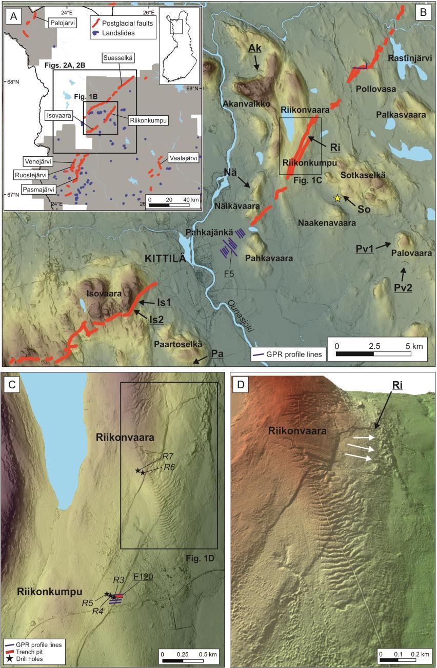
7 Riikonkumpu-Isovaara PGF, Kittilä
8 PGF s and paleoseismicity Riikonkumpu-Isovaara PGF, Kittilä Wells and Coppersmith (1994) Mattila et al., 2016 Ojala et al., submitted
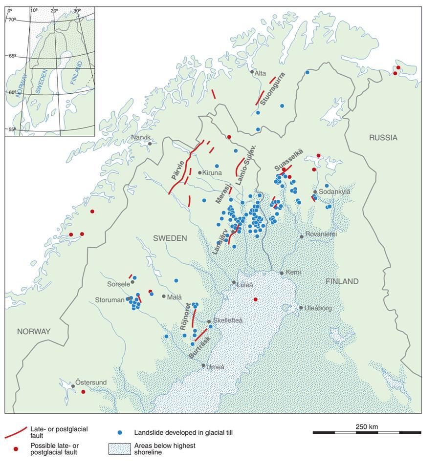

9 Landslides in Finland and Sweden

10 Landslides: types and characteristics in northern Finland Class 3: less distinct Class 4: debris flowslides with distinct scarp only (shoreline bluff failure) Class 5: creep-type Ojala et al., in prep. Class 1: debris slides with distinct scarp and colluvial toe + flow-like component Class 2: debris slides with distinct scarp and more randomly spread masses


11 Analyzing 3D characteristics from LiDAR DEMs Total area of the landslide and areas of the scarp and slid masses using the refined polygons Volume of the scarp, based on the total landslide area and scarp area only Scarp depth variability; maximum, mean, variance and 75-percentile Volume of slid masses Original slope of the terrain where the landslide occurred, determined as the average slope of the interpolated base terrain Slope of the scarp s backwall close to crown of the main scarp. This was defined as an average of the steepest points below the crown using the slope and TDR derivatives Distance from the nearest PGF Main direction of the landslide using a minimum bounding geometry Roughness index Ojala et al., in prep.
 0.91 M Vmax = log V max + (11.58 ± 0.49) 1.36 Ojala et al.")
12 Landslides and paleoseismicity (Malamud et al. 2004) M Amax = log A max + (6.85 ± 0.33) 0.91 M Vmax = log V max + (11.58 ± 0.49) 1.36 Ojala et al., in prep.
13 Paleoseismicity estimates: PGF s vs. landslides Isovaara Riikonkumpu PGF (Ojala et al.) M W Venejärvi PGF (Kuivamäki et al., 1998) M W Vaalajärvi PGF (Kuivamäki et al., 1998) M W


14 Recurrence time for seismic activity
15 Conclusions PGFs are focused on the northern part of the country. Only one fault, the Lauhanvuori PGF, could be confirmed from the central and southern part of the country. However, it is likely that more PGFs occur in South, but they can t be observed from LiDAR data Suspected seismites (seismic induced deformation in soft sediments) Marine geological evidence of seismically-induced sediment features The geometry of recognized PGFs is often complex and distinctively segmented along strike All PGFs studied by drilling and trenching are reactivated faults within ancient deformation zones Datings of landslides has provided strong indications that the recurrence cycle for seismic activity is a Moment magnitude estimates based on fault lengths, vertical displacements and area-volume data of landslides all suggest consistently MW for northern Finland Final Report 2018

16 Thank you!
Seismic activity and end- or postglacial faults in northern Fennoscandia, focusing on Sweden
 Seismic activity and end- or postglacial faults in northern Fennoscandia, focusing on Sweden Kie Oyama Student Report in Theoretical Geoecology 15 ECTS Master s Level Report passed: 31th June 2016 Supervisor:
Down-stream process transition (f (q s ) = 1)
 = 1)") Down-stream process transition (f (q s ) = 1) Detachment Limited S d >> S t Transport Limited Channel Gradient (m/m) 10-1 Stochastic Variation { Detachment Limited Equilibrium Slope S d = k sd A -θ d S
Down-stream process transition (f (q s ) = 1) Detachment Limited S d >> S t Transport Limited Channel Gradient (m/m) 10-1 Stochastic Variation { Detachment Limited Equilibrium Slope S d = k sd A -θ d S
The Greenland Analogue Project
 The Greenland Analogue Project Jon Engström, GTK Lillemor Claesson Liljedahl, SKB Anne Kontula, Posiva Oy Timo Ruskeeniemi, GTK NAWG-15, Prague 24.5.2017 The Greenland Analogue Project Greenland Analogue
STRUCTURE AND HOLOCENE SLIP OF THE JID FAULT, MONGOLIA ALTAI
 STRUCTURE AND HOLOCENE SLIP OF THE JID FAULT, MONGOLIA ALTAI LAURA K.O. SMITH AND SARAHTSETSEG PUREDORG Princeton University, Mongolian University of Science and Technology Sponsors: Ramon Gonzalez-Mieres
S. Toda, S. Okada, D. Ishimura, and Y. Niwa International Research Institute of Disaster Science, Tohoku University, Japan
 The first surface-rupturing earthquake in 20 years on a HERP major active fault: Mw=6.2 2014 Nagano, Japan, event along the Itoigawa-Shizuoka Tectonic Line is not characteristic S. Toda, S. Okada, D. Ishimura,
Active Tectonics. Earthquakes, Uplift, and Landscape. Edward A. Keller University of California, Santa Barbara
 Prentice Hall Earth Science Series SUB Gottingen 214 80416X, im ^, 2002 A 7883 lllllllilwii Active Tectonics Earthquakes, Uplift, and Landscape Second Edition V Edward A. Keller University of California,
3. GEOLOGY. 3.1 Introduction. 3.2 Results and Discussion Regional Geology Surficial Geology Mine Study Area
 3. GEOLOGY 3.1 Introduction This chapter discusses the baseline study of the geology and mineralization characteristics of the mine study area. The study consolidates existing geological data and exploration
Contrasting Behaviour of Two Recent, Large Landslides in Discontinuous Permafrost Little Salmon Lake, Yukon, Canada
 Contrasting Behaviour of Two Recent, Large Landslides in Discontinuous Permafrost Little Salmon Lake, Yukon, Canada Ryan R. Lyle BGC Engineering Inc. Kamloops, British Columbia D. Jean Hutchinson Queen
Rogun Hydropower Project
 Rogun Hydropower Project Dam site Geological investigations in the Downstream Right Bank Ascencio Lara Coyne et Bellier Almaty, 11-12 February 2013 Objectives of the presentation As the stability conditions
2. Tsunami Source Details
 2. Tsunami Source Details The Northland area faces a range of potential tsunamigenic sources that include several local and distant fault systems and underwater landslides. A NIWA study (Goff et al. 2006)
Plate Tectonics Tutoiral. Questions. Teacher: Mrs. Zimmerman. Plate Tectonics and Mountains Practice Test
 Teacher: Mrs. Zimmerman Print Close Plate Tectonics and Mountains Practice Test Plate Tectonics Tutoiral URL: http://www.hartrao.ac.za/geodesy/tectonics.html Questions 1. Fossils of organisms that lived
Ice Sheets and Late Quaternary Environmental Change
 Ice Sheets and Late Quaternary Environmental Change Martin J. Siegert Bristol Glaciology Centre, School of Geographical Sciences University of Bristol JOHN WILEY & SONS, LTD Chichester New York Weinheim
Glacial processes and landforms NGEA01, 2014
 Glacial processes and landforms NGEA01, 2014 Cecilia Akselsson Department of Physical Geography and Ecosystem Science Lund University Geomorphological processes and landforms all over the world Periglacial
Neogene Uplift of The Barents Sea
 Neogene Uplift of The Barents Sea W. Fjeldskaar A. Amantov Tectonor/UiS, Stavanger, Norway FORCE seminar April 4, 2013 The project (2010-2012) Funding companies Flat Objective The objective of the work
Earth Science, (Tarbuck/Lutgens) Chapter 10: Mountain Building
 Chapter 10: Mountain Building") Earth Science, (Tarbuck/Lutgens) Chapter 10: Mountain Building 1) A(n) fault has little or no vertical movements of the two blocks. A) stick slip B) oblique slip C) strike slip D) dip slip 2) In a(n) fault,
Earth Science, (Tarbuck/Lutgens) Chapter 10: Mountain Building 1) A(n) fault has little or no vertical movements of the two blocks. A) stick slip B) oblique slip C) strike slip D) dip slip 2) In a(n) fault,
Faults in. Houston. University. of Houston Geosciences
 DEM Programs for Active Surface Faults in Houston Richard Engelkemeir Schlumberger Information Sol lutions University of Houston Geosciences Geologic Overview Salt deposited during extension prior to sea
Answers: Internal Processes and Structures (Isostasy)
") Answers: Internal Processes and Structures (Isostasy) 1. Analyse the adjustment of the crust to changes in loads associated with volcanism, mountain building, erosion, and glaciation by using the concept
Answers: Internal Processes and Structures (Isostasy) 1. Analyse the adjustment of the crust to changes in loads associated with volcanism, mountain building, erosion, and glaciation by using the concept
T. Perron Glaciers 1. Glaciers
 T. Perron 12.001 Glaciers 1 Glaciers I. Why study glaciers? [PPT: Perito Moreno glacier, Argentina] Role in freshwater budget o Fraction of earth s water that is fresh (non-saline): 3% o Fraction of earth
Chapter 2 Plate Tectonics and the Ocean Floor
 Chapter 2 Plate Tectonics and the Ocean Floor Matching. Match the term or person with the appropriate phrase. You may use each answer once, more than once or not at all. 1. hydrothermal vents A. convergent
8.0 SUMMARY AND CONCLUSIONS
 8.0 SUMMARY AND CONCLUSIONS In November 2008, Pacific Gas and Electric (PG&E) informed the U.S. Nuclear Regulatory Commission (NRC) that preliminary results from the Diablo Canyon Power Plant (DCPP) Long
SCEC Earthquake Gates Workshop Central Death Valley Focus Area
 SCEC Earthquake Gates Workshop Central Death Valley Focus Area Fault Gates: Rheology, fault geometry, stress history or directionality? How do we recognize or suspect a fault gate? Paleoseismic or historic
Announcements. Manganese nodule distribution
 Announcements Lithospheric plates not as brittle as previously thought ESCI 322 Meet in Env. Studies Bldg Rm 60 at 1 PM on Tuesday One week (Thursday): Quiz on Booth 1994 and discussion. (Lots of odd terms
John Baldwin and Brian Gray Lettis Consultants International, Inc. Alexis Lavine AMEC Josh Goodman and Janet Sowers Fugro Consultants, Inc.
 John Baldwin and Brian Gray Lettis Consultants International, Inc. Alexis Lavine AMEC Josh Goodman and Janet Sowers Fugro Consultants, Inc. December 1, 2011 Pacific Gas & Electric SSHAC Workshop 1 San
High-Harmonic Geoid Signatures due to Glacial Isostatic Adjustment, Subduction and Seismic Deformation
 High-Harmonic Geoid Signatures due to Glacial Isostatic Adjustment, Subduction and Seismic Deformation L.L.A. Vermeersen (1), H. Schotman (1), M.-W. Jansen (1), R. Riva (1) and R. Sabadini (2) (1) DEOS,
Plate Tectonics. entirely rock both and rock
 Plate Tectonics I. Tectonics A. Tectonic Forces are forces generated from within Earth causing rock to become. B. 1. The study of the origin and arrangement of Earth surface including mountain belts, continents,
Neotectonic Implications between Kaotai and Peinanshan
 Neotectonic Implications between Kaotai and Peinanshan Abstract Longitudinal Valley was the suture zone between the Philippine Sea plate and the Eurasia plate. Peinanshan was the southest segment of the
GEOTECHNICAL ENGINEERING INVESTIGATION HANDBOOK Second Edition
 GEOTECHNICAL ENGINEERING INVESTIGATION HANDBOOK Second Edition Roy E. Hunt Taylor & Francis Taylor & Francis Croup Boca Raton London New York Singapore A CRC title, part of the Taylor & Francis imprint,
Orbital-Scale Interactions in the Climate System. Speaker:
 Orbital-Scale Interactions in the Climate System Speaker: Introduction First, many orbital-scale response are examined.then return to the problem of interactions between atmospheric CO 2 and the ice sheets
The Palmer Hill Glacial-Marine Delta, Whitefield, Maine
 Maine Geologic Facts and Localities December, 2010, Maine 44 o 10 12.16 N, 69 o 37 18.93 W Text by Woodrow Thompson, Department of Agriculture, Conservation & Forestry 1 Introduction The most recent continental
A probabilistic approach for landslide hazard analysis
 A probabilistic approach for landslide hazard analysis S. Lari, P. Frattimi, G.B. Crosta Engineering Geology 182 (2014) 3-14 報告者 : 符智傑 指導教授 : 李錫堤老師 報告日期 :2016/05/05 Introduction A general framework for
LAND DEGRADATION IN THE CARIBBEAN: QUATERNARY GEOLOGICAL PROCESSES. RAFI AHMAD
 EXTENDED TASK FORCE MEETING OF PARTICIPATING AGENCIES AND LATIN AMERICAN COUNTRIES FOR ENHANCING SOUTH-SOUTH COOPERATION BETWEEN LAC-CARIBBEAN SIDS PARTNERSHIP INITIATIVE ON LAND DEGRADATION AND SUSTAINABLE
Plate Tectonics: A Unifying Theory
 Plate Tectonics: A Unifying Theory What is Plate Tectonics? - 7 large tectonic plates and many smaller ones that break up the lithosphere - Plates are brittle and float on asthenosphere and glide past
Elastic Rebound Theory
 Earthquakes Elastic Rebound Theory Earthquakes occur when strain exceeds the strength of the rock and the rock fractures. The arrival of earthquakes waves is recorded by a seismograph. The amplitude of
Review participation point: The evidence for a fluid outer core is:
 DDA1 Continental Drift to Plate Tectonics PS 100 Chapter 28 Review participation point: The evidence for a fluid outer core is: A. Average density of the earth is greater than the density of the crust.
Full file at
 Essentials of Oceanography, 10e (Trujillo/Keller) Chapter 2 Plate Tectonics and the Ocean Floor Match the term with the appropriate phrase. You may use each answer once, more than once or not at all. A)
INTRODUCTION. Climate
 INTRODUCTION Climate Landslides are serious natural disasters in many parts of the world. Since the past 30 years, rainfall triggered landslides and debris flows had been one of the natural disasters of
Geomorphic Deformation of a Small Glaciofluvial Basin by an Upstream-Facing Thrust Fault over Multiple Glacial Cycles
 1 2 3 4 5 6 7 8 9 10 11 12 13 14 15 16 17 18 19 20 21 22 23 24 25 26 27 Geomorphic Deformation of a Small Glaciofluvial Basin by an Upstream-Facing Thrust Fault over Multiple Glacial Cycles Rachel J. Comp
Landslides and Ground Water Permeability with Respect to the. Contact Point of Glacial Lake Vermont and the Champlain Sea
 Landslides and Ground Water Permeability with Respect to the Contact Point of Glacial Lake Vermont and the Champlain Sea Sediments at Town Line Brook, Winooski, VT Michala Peabody Lara Vowles Abstract:
NUCLEAR POWER PLANT SITE SELECTION
 NUCLEAR POWER PLANT SITE SELECTION ABDELATY B. SALMAN Ex-Chairman Nuclear Materials Authority, Cairo, Egypt I. Introduction The aim of this article is to present the requirements and characteristics for
Earthquakes. Earthquake Magnitudes 10/1/2013. Environmental Geology Chapter 8 Earthquakes and Related Phenomena
 Environmental Geology Chapter 8 Earthquakes and Related Phenomena Fall 2013 Northridge 1994 Kobe 1995 Mexico City 1985 China 2008 Earthquakes Earthquake Magnitudes Earthquake Magnitudes Richter Magnitude
ENVIRONMENTAL GEOSCIENCE UNIFORM SYLLABUS
 ENVIRONMENTAL GEOSCIENCE UNIFORM SYLLABUS The Association of Professional Engineers and Geoscientists of the Province of British Columbia Note: 1. This Syllabus May Be Subject To Change 2. These Courses
Landslides Classification
 ENVIRONMENTAL GEOTECHNICS Landslides Classification Prof. Ing. Marco Favaretti University of Padova Department of Civil, Environmental and Architectural Engineering, Via Ognissanti, 39 Padova (Italy) phone:
Guidelines for Site-Specific Seismic Hazard Reports for Essential and Hazardous Facilities and Major and Special-Occupancy Structures in Oregon
 Guidelines for Site-Specific Seismic Hazard Reports for Essential and Hazardous Facilities and Major and Special-Occupancy Structures in Oregon By the Oregon Board of Geologist Examiners and the Oregon
Marine Science and Oceanography
 Marine Science and Oceanography Marine geology- study of the ocean floor Physical oceanography- study of waves, currents, and tides Marine biology study of nature and distribution of marine organisms Chemical
Ocean Basins, Bathymetry and Sea Levels
 Ocean Basins, Bathymetry and Sea Levels Chapter 4 Please read chapter 5: sediments for next class and start chapter 6 on seawater for Thursday Basic concepts in Chapter 4 Bathymetry the measurement of
Rilles Lunar Rilles are long, narrow, depressions formed by lava flows, resembling channels.
 Rilles Lunar Rilles are long, narrow, depressions formed by lava flows, resembling channels. Rugged Terra Rugged terra are mountainous regions of the moon. Wrinkle Ridges Wrinkle Ridges are created through
Before Plate Tectonics: Theory of Continental Drift
 Before Plate Tectonics: Theory of Continental Drift Predecessor to modern plate tectonics Shape and fit of the continents was the initial evidence Snider-Pelligrini (1858) Taylor (1908) Wegner (1915) Fig.
The Structure of the Earth and Plate Tectonics
 The Structure of the Earth and Plate Tectonics Structure of the Earth The Earth is made up of 4 main layers: Inner Core Outer Core Mantle Crust Crust Mantle Outer core Inner core The Crust This is where
MORPHOLOGICAL STRUCTURE AND NEOTECTONICS OF THE COASTAL ZONE OF THE MURMANSK EAST SEA-SHORE (WATERSHED ZONE OF THE VORONIA AND RYN DA RIVERS)
") Maksim V. MITIAEV Marina V. GIERASIMOWA Murmansk Marine Biological Institute of Russian Academy of Science 18 30 10, Murmansk Vladimirskaia 17, RUSSIA W>prawy Geograficzne na Spitsbergen UMCS, Lublin.
Maksim V. MITIAEV Marina V. GIERASIMOWA Murmansk Marine Biological Institute of Russian Academy of Science 18 30 10, Murmansk Vladimirskaia 17, RUSSIA W>prawy Geograficzne na Spitsbergen UMCS, Lublin.
Chapter 18 Amazing Ice: Glaciers and Ice Ages
 Chapter 18 Amazing Ice: Glaciers and Ice Ages Alpine/Valley Glaciers on Mt. Rainier, WA Types of Glaciers Continental Ice Sheet Unconfined, blankets topography, large. Modern Ex: Antarctica, Greenland
SCHUSTER SLOPE LANDSCAPE MANAGEMENT PLAN. January 15, 2015
 SCHUSTER SLOPE LANDSCAPE MANAGEMENT PLAN January 15, 2015 1 WHY DO WE NEED A LANDSCAPE MANAGEMENT PLAN? 2 PROCESS FOR DEVELOPING THE SCHUSTER SLOPE LANDSCAPE MANAGEMENT PLAN 3 NORTH DOWNTOWN SUB AREA PLAN
Offshore geo-hazards to keep in mind during prospecting and exploration activities of the Jan Mayen Micro- Continent area.
 Offshore geo-hazards to keep in mind during prospecting and exploration activities of the Jan Mayen Micro- Continent area. Anett Blischke, Iceland GeoSurvey Þórarinn S. Arnarson, of Iceland Bjarni Richter,
AN APPROACH TO THE CLASSIFICATION OF SLOPE MOVEMENTS
 Training/workshop on Earthquake Vulnerability and Multi-Hazard Risk Assessment: Geospatial Tools for Rehabilitation and Reconstruction Effort 13 31 March 2006, Islamabad, Pakistan AN APPROACH TO THE CLASSIFICATION
MS 20 Introduction To Oceanography. Lab 3: Density, Specific Gravity, Archimedes and Isostasy
 Grade 10/10 MS 20 Introduction To Oceanography Lab 3: Density, Specific Gravity, Archimedes and Isostasy Team Number: 1 Team Leader: Team Members MS 20 Laboratory Density, Specific Gravity, Archimedes
P Forsmark site investigation. Searching for evidence of late- or post-glacial faulting in the Forsmark region.
 P-03-76 Forsmark site investigation Searching for evidence of late- or post-glacial faulting in the Forsmark region Results from 2002 Robert Lagerbäck, Martin Sundh Geological Survey of Sweden (SGU) July
Lake Levels and Climate Change in Maine and Eastern North America during the last 12,000 years
 Maine Geologic Facts and Localities December, 2000 Lake Levels and Climate Change in Maine and Eastern North America during the last 12,000 years Text by Robert A. Johnston, Department of Agriculture,
Terrain Units PALEOGEOGRAPHY: LANDFORM CREATION. Present Geology of NYS. Detailed Geologic Map of NYS
 NYS TOPOGRAPHY Why so? PALEOGEOGRAPHY: LANDFORM CREATION Prof. Anthony Grande AFG 014 Present Geology of NYS Detailed Geologic Map of NYS Generalized Geology Detailed Geology Hot links to the fold out
Usually, only a couple of centuries of earthquake data is available, much shorter than the complete seismic cycle for most plate motions.
 Earthquake Hazard Analysis estimate the hazard presented by earthquakes in a given region Hazard analysis is related to long term prediction and provides a basis to expressed hazard in probabilistic terms.
Earthquakes and seismic hazard in Sweden
 Earthquakes and seismic hazard in Sweden Björn Lund, Roland Roberts & Reynir Bödvarsson Uppsala University Outline Nordic and Swedish seismicity Comparison to plate boundary seismicity in Japan. Extrapolation
Quick Clay: (Leda Clay gone bad!) Origin, Mineralogy, Chemistry and Landslides
 Origin, Mineralogy, Chemistry and Landslides") Quick Clay: (Leda Clay gone bad!) Origin, Mineralogy, Chemistry and Landslides What is Leda Clay? The fine-grained (silty clay and clayey silt) sediments that accumulated in the St. Lawrence drainage basin,
Quick Clay: (Leda Clay gone bad!) Origin, Mineralogy, Chemistry and Landslides What is Leda Clay? The fine-grained (silty clay and clayey silt) sediments that accumulated in the St. Lawrence drainage basin,
Questions and Topics
 Plate Tectonics and Continental Drift Questions and Topics 1. What are the theories of Plate Tectonics and Continental Drift? 2. What is the evidence that Continents move? 3. What are the forces that
Tsunami, earthquakes and volcanic eruptions. Tsunami, earthquakes and volcanic eruptions. Destruction of Moawhitu. Plate tectonics: terminology
 Tsunami, earthquakes and volcanic eruptions Tsunami, earthquakes and volcanic eruptions Tsunami: Wavelenths > 200 km Very fast in open ocean Destruction of Moawhitu Brian Flintoff, New Zealand Plate tectonics
GPR survey and field work summary in Siilinjärvi mine during July 2014
 GEOLOGICAL SURVEY OF FINLAND Groundwater Espoo 21.6.2016 67/2016 GPR survey and field work summary in Siilinjärvi mine during July 2014 Samrit Luoma, Juha Majaniemi, Tiina Kaipainen, and Antti Pasanen
3.1 GEOLOGY AND SOILS Introduction Definition of Resource
 3.1 GEOLOGY AND SOILS 3.1.1 Introduction 3.1.1.1 Definition of Resource The geologic resources of an area consist of all soil and bedrock materials. This includes sediments and rock outcroppings in the
Topic 12 Review Book Earth s Dynamic Crust and Interior
 Topic 12 Review Book Earth s Dynamic Crust and Interior Define the Vocabulary 1. asthenosphere 2. continental crust 3. Convection current 4. Convergent plate boundary 5. Divergent plate boundary 6. earthquake
SEDIMENTOLOGICAL CHARACTERISTICS OF LATE WEICHSELIAN HOLOCENE DEPOSITS OF THE SUURPELTO AREA IN ESPOO, SOUTHERN FINLAND
 Applied Quaternary research in the central part of glaciated terrain, edited by Peter Johansson and Pertti Sarala. Geological Survey of Finland, Special Paper 46, 147 156, 2007. SEDIMENTOLOGICAL CHARACTERISTICS
Radar Remote Sensing: Monitoring Ground Deformations and Geohazards from Space
 Radar Remote Sensing: Monitoring Ground Deformations and Geohazards from Space Xiaoli Ding Department of Land Surveying and Geo-Informatics The Hong Kong Polytechnic University A Question 100 km 100 km
Directed Reading. Section: How Mountains Form MOUNTAIN RANGES AND SYSTEMS. Skills Worksheet
 Skills Worksheet Directed Reading Section: How Mountains Form 1. How high is Mount Everest? a. about 1980 km above sea level b. more than 8 km below sea level c. more than 8 km above sea level d. more
Supplementary Fig. 1. Locations of thinning transects and photos of example samples. Mt Suess/Gondola Ridge transects extended metres above
 Supplementary Fig. 1. Locations of thinning transects and photos of example samples. Mt Suess/Gondola Ridge transects extended 260 24 metres above the modern surface of Mackay Glacier, and included 16
Geomorphology and Landslide Hazard Models
 Geomorphology and Landslide Hazard Models Steve Parry GeoRisk Solutions Key component of interpreting geomorphology and therefore hazard at a site is the use of API The purpose of this talk is not to try
PERIGLACIAL PHENOMENA AFFECTING NUCLEAR WASTE DISPOSAL
 PERIGLACIAL PHENOMENA AFFECTING NUCLEAR WASTE DISPOSAL HEIKKI NIINI, NURIA MARCOS and TIMO RUSKEENIEMI HEIKKI NIINI, NURIA MARCOS and TIMO RUSKEENIEMI, 1997. Periglacial phenomena affecting nuclear waste
The Seattle-area geologic mapping project and the geologic framework of Seattle
 The Seattle-area geologic mapping project and the geologic framework of Seattle Troost, K.G., D.B. Booth, S.A. Shimel, and M.A. O Neal, Univ. of Washington, Seattle 98195 Introduction The Puget Lowland
MOUSLOPOULOU V., ANDREOU C., ATAKAN K. FOUNTOULIS I.,
 ΔΗΜΟΣΙΕΥΣΗ Νο 80 MOUSLOPOULOU V., ANDREOU C., ATAKAN K. FOUNTOULIS I., (2001) Paleoseismological investigations along the Kera Fault Zone, Western Crete: Implications for Seismic Hazard Assessment. Proc.
The Ocean Floor Earth Science, 13e Chapter 13
 The Ocean Floor Earth Science, 13e Chapter 13 Stanley C. Hatfield Southwestern Illinois College The vast world ocean Earth is often referred to as the blue planet Seventy-one percent of Earth s surface
24. Ocean Basins p
 24. Ocean Basins p. 350-372 Background The majority of the planet is covered by ocean- about %. So the majority of the Earth s crust is. This crust is hidden from view beneath the water so it is not as
Directed Reading. Section: The Water Planet. surface is called the a. Earth s ocean. b. Pacific Ocean. c. salt-water ocean. d. global ocean.
 Skills Worksheet Directed Reading Section: The Water Planet 1. The body of salt water covering nearly three-quarters of the Earth s surface is called the a. Earth s ocean. b. Pacific Ocean. c. salt-water
4. The map below shows a meandering stream. Points A, B, C, and D represent locations along the stream bottom.
 1. Sediment is deposited as a river enters a lake because the A) velocity of the river decreases B) force of gravity decreases C) volume of water increases D) slope of the river increases 2. Which diagram
General Geologic Setting and Seismicity of the FHWA Project Site in the New Madrid Seismic Zone
 General Geologic Setting and Seismicity of the FHWA Project Site in the New Madrid Seismic Zone David Hoffman University of Missouri Rolla Natural Hazards Mitigation Institute Civil, Architectural & Environmental
FINITE ELEMENT SIMULATION OF RETROGRESSIVE FAILURE OF SUBMARINE SLOPES
 FINITE ELEMENT SIMULATION OF RETROGRESSIVE FAILURE OF SUBMARINE SLOPES A. AZIZIAN & R. POPESCU Faculty of Engineering & Applied Science, Memorial University, St. John s, Newfoundland, Canada A1B 3X5 Abstract
The Geology of Sebago Lake State Park
 Maine Geologic Facts and Localities September, 2002 43 55 17.46 N, 70 34 13.07 W Text by Robert Johnston, Department of Agriculture, Conservation & Forestry 1 Map by Robert Johnston Introduction Sebago
Late 20 th Century Tests of the Continental Drift Hypothesis
 Late 20 th Century Tests of the Continental Drift Hypothesis 5 Characteristics of the Ocean Trenches Unless otherwise noted the artwork and photographs in this slide show are original and by Burt Carter.
Lecture 9 faults, folds and mountain building
 Lecture 9 faults, folds and mountain building Rock deformation Deformation = all changes in size, shape, orientation, or position of a rock mass Structural geology is the study of rock deformation Deformation
The Ocean Floor Chapter 14. Essentials of Geology, 8e. Stan Hatfield and Ken Pinzke Southwestern Illinois College
 The Ocean Floor Chapter 14 Essentials of Geology, 8e Stan Hatfield and Ken Pinzke Southwestern Illinois College The vast world ocean Earth is often referred to as the water planet 71% of Earth s surface
OIKOS > landslide > mechanism >predisposing causes
 predisposing causes and trigger OIKOS > landslide > mechanism >predisposing causes Landslides are events that occur in space and time. As such, it is usually possible to identify both one or more landslide
USU 1360 TECTONICS / PROCESSES
 USU 1360 TECTONICS / PROCESSES Observe the world map and each enlargement Pacific Northwest Tibet South America Japan 03.00.a1 South Atlantic Arabian Peninsula Observe features near the Pacific Northwest
Sequence Stratigraphy. Historical Perspective
 Sequence Stratigraphy Historical Perspective Sequence Stratigraphy Sequence Stratigraphy is the subdivision of sedimentary basin fills into genetic packages bounded by unconformities and their correlative
Differentiating earthquake tsunamis from other sources; how do we tell the difference?
 Differentiating earthquake tsunamis from other sources; how do we tell the difference? David Tappin (1), Stephan Grilli (2), Jeffrey Harris (2), Timothy Masterlark (3), James Kirby (4), Fengyan Shi Shi
Hints of active deformation in the southern Adriatic foreland: Holocene tectonics along the Apulia offshore (Italy)
") Hints of active deformation in the southern Adriatic foreland: Holocene tectonics along the Apulia offshore (Italy) Domenico Ridente^, Umberto Fracassi*, Daniela Di Bucci, Fabio Trincardi^ ^ & Gianluca
Hints of active deformation in the southern Adriatic foreland: Holocene tectonics along the Apulia offshore (Italy) Domenico Ridente^, Umberto Fracassi*, Daniela Di Bucci, Fabio Trincardi^ ^ & Gianluca
Faults, folds and mountain building
 Faults, folds and mountain building Mountain belts Deformation Orogens (Oro = Greek all changes for mountain, in size, shape, genesis orientation, = Greek for or formation) position of a rock mass Structural
Rock Suitability Classification for POPLU
 The research leading to these results has received funding from the European Union's European Atomic Energy Community's (Euratom) Seventh Framework Programme FP7/2011-2013, 2013, under Grant Agreement
ISSN Scientific Technical Report STR 07/05. DOI: /GFZ.b GeoForschungsZentrum Potsdam
 ISSN 1610-0956 Ingo Sasgen, Robert Mulvaney, Volker Klemann and Detlef Wolf Glacial-isostatic adjustment and sea-level change near Berkner Island, Antarctica Ingo Sasgen Dep. 1: Geodesy and Remote Sensing
Do Now: Vocabulary: Objectives. Vocabulary: 1/5/2016. Wegener? (Can they move?) the idea that continents have moved over time?
 the idea that continents have moved over time?") Do Now: 1. Who was Alfred Wegener? 2. What was Pangaea? 3. Are continents fixed? (Can they move?) 4. What evidence supports the idea that continents have moved over time? Objectives What evidence suggests
Do Now: 1. Who was Alfred Wegener? 2. What was Pangaea? 3. Are continents fixed? (Can they move?) 4. What evidence supports the idea that continents have moved over time? Objectives What evidence suggests
depression above scarp scarp
 1 LAB 1: FIELD TRIP TO McKINLEYVILLE AND MOUTH OF THE MAD RIVER OBJECTIVES: a. to look at geomorphic and geologic evidence for large scale thrust-faulting of young sediments in the Humboldt Bay region
WATER AND GEOSCIENCE TALEB ODEH¹ ², RICHARD GLOAGUEN², MARIO SCHIRMER³, STEFAN GEYER¹, TINO RÖDIGER¹, CHRISTIAN SIEBERT¹
 Investigation of catchment areas migrations through a sinstral and dextral strike slip faults: the case study of Zerka Ma in and Al Hasa catchment areas, east of the Dead Sea in Jordan. TALEB ODEH¹ ²,
Module 8 SEISMIC SLOPE STABILITY (Lectures 37 to 40)
") Lecture 40 Topics Module 8 SEISMIC SLOPE STABILITY Lectures 37 to 40) 8.6.15 Analysis of Weakening Instability 8.6.16 Flow Failure Analysis 8.6.17 Analysis of Stability 8.6.18 Analysis of Deformation 8.6.19
Lecture 40 Topics Module 8 SEISMIC SLOPE STABILITY Lectures 37 to 40) 8.6.15 Analysis of Weakening Instability 8.6.16 Flow Failure Analysis 8.6.17 Analysis of Stability 8.6.18 Analysis of Deformation 8.6.19
3D modelling at the Geological Survey of Finland (GTK)
") 3D modelling at the Geological Survey of Finland (GTK) E Laine, A Pasanen & 3D team at GTK 28.7.2016 1 Contents 1. GTK Geological Survey of Finland 2. GTK s 3D geological model storage 3. Examples 4. Future:
3D modelling at the Geological Survey of Finland (GTK) E Laine, A Pasanen & 3D team at GTK 28.7.2016 1 Contents 1. GTK Geological Survey of Finland 2. GTK s 3D geological model storage 3. Examples 4. Future:
Greenbush Landslide: June 30 - July 2, 2006
 Maine Geologic Facts and Localities December, 2006 45 o 4 59.76 N, 68 o 38 56.08 W Text by Michael E. Foley, Department of Agriculture, Conservation & Forestry 1 Map by USGS Aerial photo from Introduction
Moho (Mohorovicic discontinuity) - boundary between crust and mantle
 - boundary between crust and mantle") Earth Layers Dynamic Crust Unit Notes Continental crust is thicker than oceanic crust Continental Crust Thicker Less Dense Made of Granite Oceanic Crust Thinner More Dense Made of Basalt Moho (Mohorovicic
Earth Layers Dynamic Crust Unit Notes Continental crust is thicker than oceanic crust Continental Crust Thicker Less Dense Made of Granite Oceanic Crust Thinner More Dense Made of Basalt Moho (Mohorovicic
Passive margin earthquakes as indicators of intraplate deformation
 Passive margin earthquakes as indicators of intraplate deformation Emily Wolin and Seth Stein Northwestern University April 23, 2010 Seismicity of the North 1920-2009 American Passive Margin 1933 Baffin
GEOLOGY - GL4 INTERPRETING THE GEOLOGICAL RECORD
 Candidate Name Centre Number 2 Candidate Number GCE A level 1214/01 GEOLOGY - GL4 INTERPRETING THE GEOLOGICAL RECORD A.M. MONDAY, 21 June 2010 2 hours Section A 1. 2. 3. 15 15 15 1214 01 01 4. 15 Section