The Greenland Analogue Project
|
|
|
- Erica Briggs
- 6 years ago
- Views:
Transcription
1 The Greenland Analogue Project Jon Engström, GTK Lillemor Claesson Liljedahl, SKB Anne Kontula, Posiva Oy Timo Ruskeeniemi, GTK NAWG-15, Prague
, Posiva (Finland) and NWMO (Canada) 4.")

2 The Greenland Analogue Project Greenland Analogue Project (1/4) Co-ordinating and funding organizations SKB (Sweden), Posiva (Finland) and NWMO (Canada) 4.1 M (6 MUSD) for Research partners Geological Surveys GTK and GEUS Universities: UK/Aberystwyth, Bristol, Edinburgh, Swansea; USA/ Montana, Wyoming, Colorado, Indiana, Princeton, Washington; Canada/Waterloo, Toronto; Sweden/Stockholm, Uppsala Geosigma AB, Lawrence Berkeley National Laboratory etc.

 Direct studies of the basal hydrology")
 Groundawter chemistry,")
3 SPA (Alun Hubbard) Indirect studies of the basal hydrological system and groundwater formation. AWS, GPS, radar, seismics, remote sensing. SPB (Joel Harper) Direct studies of the basal hydrology & groundwater formation. Hot water ice drilling. SPC (Timo Ruskeeniemi) Groundawter chemistry, groundwater flow and permafrost. Bedrock drilling.

4 a b SPC Permafrost DH-GAP01 The Greenland Analogue Project Greenland Analogue Project (4/4) SPC SPB DH-GAP03 DH-GAP04 Talik Lake MAIN RESEARCH OUTCOME Permafrost SPA X X SPB SPA N The results and research undertaken as part of the GAP has advanced the scientific understanding of hydrological processes associated with a retreating ice sheet GrIS. X X

5 The Greenland Analogue Project Hydrologic conditions at the ice sheet bed were found to vary across. Between the ice divide and the margin, there is evidence for three different basal zones as defined by the amount and configuration of meltwater: the frozen zone, the wet bed zone, and the surface-drainage zone. These zones result from surface, bed, and internal ice flow processes, and are likely representative of Northern Hemisphere ice sheets in a similar stage of development to the current GrIS.

6 GAP has resulted in extensive and new process understanding and we can from the first time through observations describe the following: How pressure is varying through time and space underneath an ice sheet Groundwater formation underneath and in the vicinity of an ice sheet Important for the Groundwater models in Safety Assessments for RWD To what depth the meltwater is possible to penetrate into the bedrock in vicinity of an ice sheet What is the geochemical composition of the ground/meltwater in the bedrock underneath an ice sheet The effect of an ice sheet in a periglacial environment on the groundwater flow Important for the Bentonite stability in Safety Assessments for RWD

7 GAP is officially closed and the results are presented in the two final reports: The Greenland Analogue Project: Data and Processes, The Greenland Analogue Project: Final report Final reports available at: Alun Hubbard
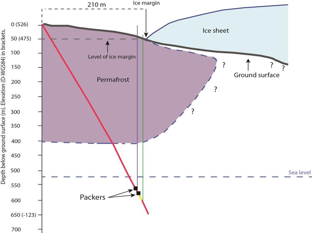
8 Borehole DH-GAP04 Groundwater chemistry, hydrology & permafrost DH-GAP04 KBS-3 depth DH-GAP03 Permafrost hole DH-GAP01 Talik hole 2 km


9 DH-GAP m, 70 ~400 m permafrost Hot water drilling Posiva Flow Log Instrument setup Lillemor Claesson Liljedahl


10 The Greenland Analogue Project
11 Ongoing and future plans SKB continues monitoring of DH-GAP04 (at least until 2020). AWS-network on the ice sheet (KAN_U, KAN_M, KAN_L + KAN_B) through GEUS/Dirk van As (at least until 2020). Ice drilling project ICE to study recharge completed Funded by SKB, Posiva, Nagra and NWMO. Carried out by Univ. Montana and Univ. Wyoming. Unique data sets ongoing publication in scientific journals. Validation of the permafrost model used by SKB and Posiva in safety assessments + coupling of the permafrost model and the ElmerICE ice sheet model. Paleo climatologic inverse modelling of borehole temperatures from DH- GAP04 (Jan Sundberg, Volker Rath). NSF-application PIRE to further study the dynamic coupling of the ice sheet/groundwater system (field studies, ice modelling, groundwater modelling) to better understand the subglacial drainage system (Joel Harper & Neil Humphrey). SKB, Posiva and Nagra participates in the project if funded. Some day..donate the GAP infrastructure to the research community.


12 Comments? Questions? For the safety of future generations... Mind the GAP Good research makes good solutions


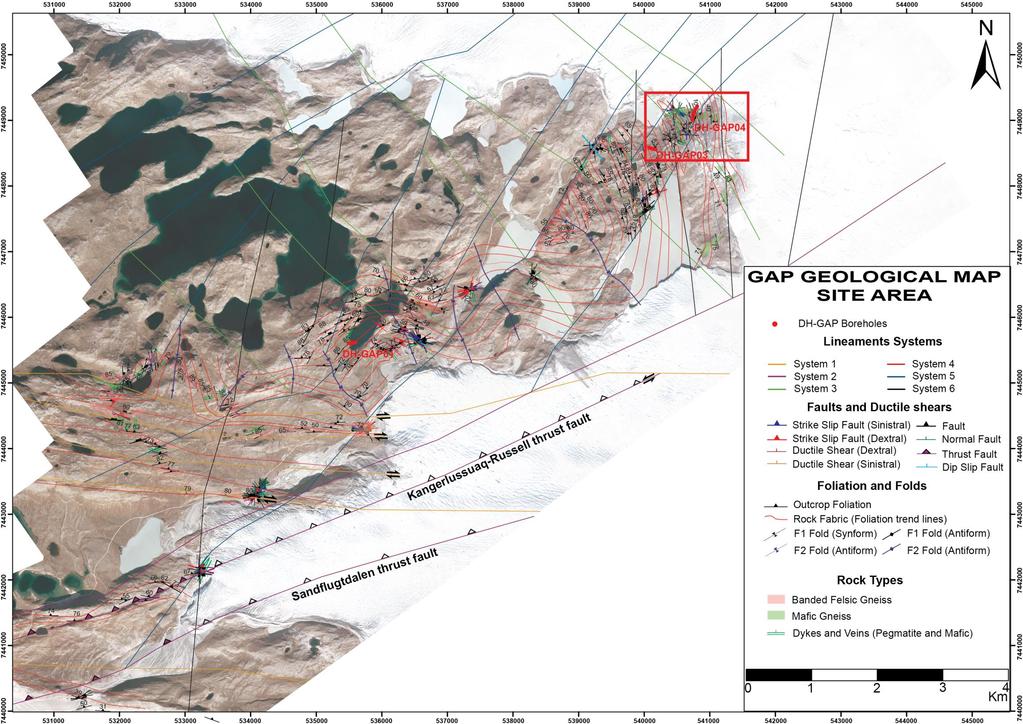
13 Constructing GAP Lineament model Interpretation of the Geological map and the Topographical Elevation data Geophysical interpretation of Aeromagnetic data GAP Lineament model Klint, K.E.S.; Engström, J.; Parmenter, A.; Ruskeeneimi, T.; Liljedahl L.C.; Lehtinen, A. Lineament mapping and geological history of the Kangerlussuaq region, southern West Greenland. Geol. Sur. Denmark Greenland Bull. 2013, 28,


14 Lindbäck K, Pettersson R, Spectral roughness and glacial erosion of a land-terminating section of the Greenland Ice Sheet. Geomorphology, Volume 238, Pages Fieldwork Photo Sam Doyle.


15 Updated Lineament map from new produced DEM, extending further in under the ice sheet. The type and character of the lineaments were verified with field work and were classified as different deformation zones. Type 1 Type 2 Type 3

16 Deformation zone model of site area
")


17 1 ) A 3 ) B 2 ) 1) Ice bed elevation based on GPR 2) N-S intersection from Russells Glacier to Isunnguata Sermia 3) Surpac View of the aforementioned intersection in 3D A B


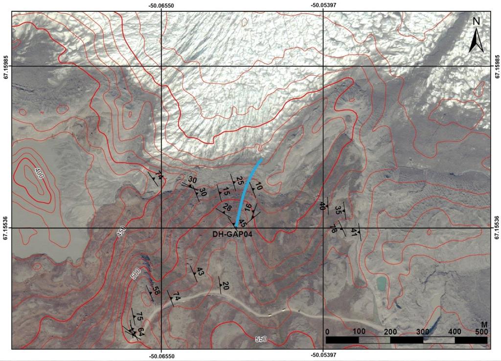
18 Deformation zones: DH-GAP04 area Deformation zones Orthomap view Top view SURPAC view DH-GAP04 DH-GAP03
19


20 Geological map of DH-GAP03 & DH-GAP04 area Cross-section E-W orientated section A-B in the map


21 Surpac view of the folded bedrock. View from NW. Surpac view of the folded bedrock. View from SE.

22 All fractures in DH-GAP04 UP MID UP LOW MID LOW


23 1. Fractures & Faults within Permafrost and below Permafrost Within Permafrost 2. Below Permafrost


24 Fractures & Faults below Permafrost 1. UP 2. MID LOW 1. Up & Mid section 2. Lower section
Modelling of surface to basal hydrology across the Russell Glacier Catchment
 Modelling of surface to basal hydrology across the Russell Glacier Catchment Sam GAP Modelling Workshop, Toronto November 2010 Collaborators Alun Hubbard Centre for Glaciology Institute of Geography and
Underground nuclear waste storage
 Underground nuclear waste storage Groundwater flow and radionuclide transport Jan-Olof Selroos Cargese Summer School, July 5, 2018 Contents: Concept for geological disposal of nuclear waste A few words
TEMPORAL EVOLUTION OF BASAL WATER PRESSURE AND ICE VELOCITY ALONG A 50 KM FLOW LINE TRANSECT OF WESTERN GREENLAND
 University of Montana ScholarWorks at University of Montana Graduate Student Theses, Dissertations, & Professional Papers Graduate School 2015 TEMPORAL EVOLUTION OF BASAL WATER PRESSURE AND ICE VELOCITY
NAWG-15 Workshop. UJV-Rez, Prague th May, 2017
 NAWG-15 Workshop UJV-Rez, Prague 23-26 th May, 2017 Tuesday 23 rd May Introduction and registration 08:45 09:00 Opening of the course and organisational aspects 09:00 09:15 Current status of the Czech
Timo Ruskeeniemi, Ismo Aaltonen, Antero Lindberg, Jussi Mattila, Nicklas Nordbäck, Antti E.K. Ojala, Jukka-Pekka Palmu and Raimo Sutinen
 Timo Ruskeeniemi, Ismo Aaltonen, Antero Lindberg, Jussi Mattila, Nicklas Nordbäck, Antti E.K. Ojala, Jukka-Pekka Palmu and Raimo Sutinen Quaternary glaciations and neotectonics During the Quaternary (2.6
Ice Thickness and Subglacial Topography Studies by Ground Penetrating Radar during the XX Indian Antarctic Expedition
 Ice Thickness and Subglacial Topography Studies by Ground Penetrating Radar during the XX Indian Antarctic Expedition J.T. GERGAN and RENOJ J. THAYYEN Wadia Institute of Himalayan Geology, Dehradun, Uttaranchal
PERIGLACIAL PHENOMENA AFFECTING NUCLEAR WASTE DISPOSAL
 PERIGLACIAL PHENOMENA AFFECTING NUCLEAR WASTE DISPOSAL HEIKKI NIINI, NURIA MARCOS and TIMO RUSKEENIEMI HEIKKI NIINI, NURIA MARCOS and TIMO RUSKEENIEMI, 1997. Periglacial phenomena affecting nuclear waste
GPR AS A COST EFFECTIVE BEDROCK MAPPING TOOL FOR LARGE AREAS. Abstract
 GPR AS A COST EFFECTIVE BEDROCK MAPPING TOOL FOR LARGE AREAS Dr. Jutta L. Hager, Hager GeoScience, Inc., Waltham, MA Mario Carnevale, Hager GeoScience, Inc., Waltham, MA Abstract Hager GeoScience, Inc.
Borehole radar measurements aid structure geological interpretations
 Ž. Journal of Applied Geophysics 43 2000 www.elsevier.nlrlocaterjappgeo Borehole radar measurements aid structure geological interpretations S. Wanstedt ), S. Carlsten, S. Tiren GEOSIGMA, Box 894, S-751
Modelling meltwater delivery to the ice-bed interface through fractures at the margin of the Greenland Ice Sheet
 Modelling meltwater delivery to the ice-bed interface through fractures at the margin of the Greenland Ice Sheet Caroline Clason, Douglas Mair & Peter Nienow CESM Land Ice Working Group Meeting, January
APPLICATION OF 1D HYDROMECHANICAL COUPLING IN TOUGH2 TO A DEEP GEOLOGICAL REPOSITORY GLACIATION SCENARIO
 PROCEEDINGS, TOUGH Symposium 2015 Lawrence Berkeley National Laboratory, Berkeley, California, September 28-30, 2015 APPLICATION OF 1D HYDROMECHANICAL COUPLING IN TOUGH2 TO A DEEP GEOLOGICAL REPOSITORY
Rock Suitability Classification for POPLU
 The research leading to these results has received funding from the European Union's European Atomic Energy Community's (Euratom) Seventh Framework Programme FP7/2011-2013, 2013, under Grant Agreement
Glacial processes and landforms NGEA01, 2014
 Glacial processes and landforms NGEA01, 2014 Cecilia Akselsson Department of Physical Geography and Ecosystem Science Lund University Geomorphological processes and landforms all over the world Periglacial
Subglacial Control on Glacier Flow in Northern Greenland
 Subglacial Control on Glacier Flow in Northern Greenland Beáta Csathó (University at Buffalo, SUNY, Buffalo, NY), C.J. van der Veen (U. of Kansas, Lawrence, KS) Ralph van Frese and Tim Leftwich (The Ohio
GEOSPATIAL ANALYSIS OF GLACIAL DYNAMICS OF SHIGAR AND SHAYOK BASINS. Syed Naseem Abbas Gilany 1
 GEOSPATIAL ANALYSIS OF GLACIAL DYNAMICS OF SHIGAR AND SHAYOK BASINS 1 OUTLINE Introduction Problem Statement / Rationale Objectives Material and Methods Study Area Datasets Required Data Analysis / Assessment
Supraglacial Lake Formation and What it Means for Greenland s Future
 Supraglacial Lake Formation and What it Means for Greenland s Future GreenPeace Ulyana Nadia Horodyskyj GEOG 5271 questions of interest How, when and where do these lakes form in Greenland? How do these
GEOL.3250 Geology for Engineers Glacial Geology
 GEOL.3250 Geology for Engineers Glacial Geology NAME Part I: Continental Glaciation Continental glaciers are large ice sheets that cover substantial portions of the land area. In the region of accumulation
GPR survey and field work summary in Siilinjärvi mine during July 2014
 GEOLOGICAL SURVEY OF FINLAND Groundwater Espoo 21.6.2016 67/2016 GPR survey and field work summary in Siilinjärvi mine during July 2014 Samrit Luoma, Juha Majaniemi, Tiina Kaipainen, and Antti Pasanen
Glacier Hydrology. Why should you care?
 Glacier Hydrology Why should you care? Climate Local Meteorology Surface Mass And Energy Exchange Net Mass Balance Dynamic Response Effect on Landscape Changes In Geometry Water Flow PRACTICAL MATTERS:
Changing Landscapes: Glaciated Landscapes. How do glaciers move?
 Changing Landscapes: Glaciated Landscapes How do glaciers move? What you need to know Differences between cold-and warm-based glaciers, their locations and rates of movement Glacier ice movement including
Ice flow dynamics and surface meltwater flux at a land-terminating sector of the Greenland ice sheet
 Journal of Glaciology, Vol. 59, No. 216, 2013 doi:10.3189/2013jog12j143 687 Ice flow dynamics and surface meltwater flux at a land-terminating sector of the Greenland ice sheet Andrew A.W. FITZPATRICK,
Drilling 2.5 km in the Swedish Caledonides: The COSC project
 Drilling 2.5 km in the Swedish Caledonides: The COSC project Christopher Juhlin Uppsala University, Sweden David Gee, Henning Lorenz (Uppsala University, Sweden) Christophe Pascal (Ruhr University, Germany)
Lecture 10 Glaciers and glaciation
 Lecture 10 Glaciers and glaciation Outline Importance of ice to people! Basics of glaciers formation, classification, mechanisms of movement Glacial landscapes erosion and deposition by glaciers and the
Using Ice Thickness and Bed Topography to Pick Field Sites Near Swiss Camp, Greenland
 Lauren Andrews 6 May 2010 GEO 386G: GIS final project Using Ice Thickness and Bed Topography to Pick Field Sites Near Swiss Camp, Greenland Problem Formulation My primary goal for this project is to map
Initial Borehole Drilling and Testing in Central Huron,
 JULY 2016 PRELIMINARY ASSESSMENT OF POTENTIAL SUITABILITY Initial Borehole Drilling and Testing in Central Huron, Huron-Kinloss and South Bruce DRAFT FOR DISCUSSION WITH COMMUNITIES In 2012, at the request
SVALBARD. Environmental changes in Svalbard since the last glacial maximum THE ROLE OF PERMAFROST
 SVALBARD Environmental changes in Svalbard since the last glacial maximum THE ROLE OF PERMAFROST Bernd Etzelmüller, Oslo, Norway With contribution by Hanne H. Christiansen, UNIS, Svalbard Discussion points
GEOL4714 Final Exam Fall 2005, C. H. Jones instructor
 GEOL4714 Final Exam Fall 2005 p. 1 GEOL4714 Final Exam Fall 2005, C. H. Jones instructor Name: Student ID #: Feel free to use the back of the sheets for answers needing more space. (1) (10 pts) For each
Glacial Modification of Terrain
 Glacial Modification Part I Stupendous glaciers and crystal snowflakes -- every form of animate or inanimate existence leaves its impress upon the soul of man. 1 -Orison Swett Marden Glacial Modification
Electrical imaging techniques for hydrological and risk assessment studies
 Séminaire IPG le 9 mars 2006 Strasbourg Institute of Geophysics ETH Hoenggerberg CH-8093 Zurich Electrical imaging techniques for hydrological and risk assessment studies Laurent Marescot laurent@aug.ig.erdw.ethz.ch
New observations obtained via applying remote sensing methods in geological hazard assessment, Southern Ethiopia
 New observations obtained via applying remote sensing methods in geological hazard assessment, Southern Ethiopia Veronika Kopačková, Jan Mišurec Remote sensing Unit Czech Geological Survey, Klárov 3, Prague
PRINCETON BASIN (92H/7E, 8W. 9W, 10E)
") PRINCETON BASIN (92H/7E, 8W. 9W, 10E) By R. D. McMechan INTRODUCTION Remapping of the Princeton basin, south-central British Columbia, was undertaken during the summer of 1975 in order to: (1) produce
PRINCETON BASIN (92H/7E, 8W. 9W, 10E) By R. D. McMechan INTRODUCTION Remapping of the Princeton basin, south-central British Columbia, was undertaken during the summer of 1975 in order to: (1) produce
P Forsmark site investigation. Ground penetrating radar and resistivity measurements for overburden investigations
 P-03-43 Forsmark site investigation Ground penetrating radar and resistivity measurements for overburden investigations Johan Nissen, Malå Geoscience AB April 2003 Svensk Kärnbränslehantering AB Swedish
A25 Very High Resolution Hard Rock Seismic Imaging for Excavation Damage Zone Characterisation
 A25 Very High Resolution Hard Rock Seismic Imaging for Excavation Damage Zone Characterisation C. Cosma* (Vibrometric Oy), N. Enescu (Vibrometric Oy) & E. Heikkinen (Pöyry Finland Oy) SUMMARY Seismic and
Near-margin ice thickness and subglacial water routing, Leverett Glacier, Greenland
 Arctic, Antarctic, and Alpine Research An Interdisciplinary Journal ISSN: 1523-0430 (Print) 1938-4246 (Online) Journal homepage: https://www.tandfonline.com/loi/uaar20 Near-margin ice thickness and subglacial
Case Study: University of Connecticut (UConn) Landfill
 Landfill") Case Study: University of Connecticut (UConn) Landfill Problem Statement:» Locate disposal trenches» Identify geologic features and distinguish them from leachate and locate preferential pathways in fractured
Case Study: University of Connecticut (UConn) Landfill Problem Statement:» Locate disposal trenches» Identify geologic features and distinguish them from leachate and locate preferential pathways in fractured
Two Modes of Accelerated Glacier Sliding Related to Water
 University of Wyoming Wyoming Scholars Repository Geology and Geophysics Faculty Publications Geology and Geophysics 6-29-2007 Two Modes of Accelerated Glacier Sliding Related to Water J. T. Harper Neil
Antarctica & Greenland, Theory & Observations
 Ocean-Ice Interactions: Antarctica & Greenland, Theory & Observations Keck Institute for Space Studies September 9, 2013 David HOLLAND New York University + Abu Dhabi 0 Overview: Ocean-Ice Interface Delivery
Glacial Erosion II: Processes, Rates & Landforms. Bernard Hallet ESS
 Glacial Erosion II: Processes, Rates & Landforms Bernard Hallet ESS 685-2409 hallet@u.washington.edu Housekeeping for the day Friday Discussion Section Holiday Friday no discussion session Monday Discussion
CARD #1 The Shape of the Land: Effects of Crustal Tilting
 CARD #1 The Shape of the Land: Effects of Crustal Tilting When we look at a birds-eye view of the Great Lakes, it is easy to assume the lakes are all at a similar elevation, but viewed in this way, we
PHYSICAL GEOGRAPHY. By Brett Lucas
 PHYSICAL GEOGRAPHY By Brett Lucas GLACIAL PROCESSES Glacial Processes The Impact of Glaciers on the Landscape Glaciations Past and Present Types of Glaciers Glacier Formation and Movement The Effects of
Reconstruction of the Vistula ice stream lobe during LGM: preliminary results of the research project
 Ice, water, humans Quaternary landscape evolution in the Peribaltic Region 35th Annual conference of the German Quaternary Association DEUQUA e.v. 12th Annual Conference of the INQUA PeriBaltic WG 13th-17th
Ice Sheets and Glaciers
 Ice Sheets and Glaciers Technical University of Denmark Kees van der Veen Department of Geography University of Kansas Why are glaciers and ice sheets important? Large volume of fresh water stored in ice
Impact of permafrost on repository safety
 Impact of permafrost on repository safety IGD TP Exchange Forum, Prague, 29 October 2013 Ton Wildenborg (TNO) Richard Shaw (BGS) Simon Norris (NDA) My presentation Uncertainties Permafrost related processes
Buried-valley Aquifers: Delineation and Characterization from Reflection Seismic and Core Data at Caledon East, Ontario
 Buried-valley Aquifers: Delineation and Characterization from Reflection Seismic and Core Data at Caledon East, Ontario Russell, H.A.J. 1, S.E. Pullan 1, J.A. Hunter 1, D.R. Sharpe 1, and S. Holysh 2 1
Reconstructing the Groundwater Flow in the Baltic Basin During the Last Glaciation
 ESF projekts Starpnozaru zinātnieku grupas un modeļu sistēmas izveide pazemes ūdeņu pētījumiem Reconstructing the Groundwater Flow in the Baltic Basin During the Last Glaciation Tomas Saks, Juris Seņņikovs,
Geomorphologic Mapping by Airborne Laser Scanning in Southern Victoria Land
 Geomorphologic Mapping by Airborne Laser Scanning in Southern Victoria Land Bea Csatho, Terry Wilson, Tony Schenk, Garry McKenzie, Byrd Polar Research Center, The Ohio State University, Columbus, OH William
Radar Investigations of Ice Stream Margins: Data Report
 Radar Investigations of Ice Stream Margins: Data Report N. A. Nereson and C. F. Raymond Department of Earth and Space Sciences, Box 35131, University of Washington, Seattle, WA 98195-131 Contents 1 Introduction
Initial Borehole Drilling and Testing in or Near Ignace
 JUNE 2016 PRELIMINARY ASSESSMENT OF POTENTIAL SUITABILITY Initial Borehole Drilling and Testing in or Near Ignace DRAFT FOR DISCUSSION WITH COMMUNITIES In 2010, the Nuclear Waste Management Organization
Subglacial Access Working Group Access Drilling Priorities in Subglacial Aquatic Environments
 Subglacial Access Working Group Access Drilling Priorities in Subglacial Aquatic Environments 1) Summary: Subglacial hydrodynamics are an important yet poorly understood factor in ice sheet dynamics in
Initial Borehole Drilling in the Hornepayne and Manitouwadge Area
 MAY 2017 PRELIMINARY ASSESSMENT OF POTENTIAL SUITABILITY Initial Borehole Drilling in the Hornepayne and Manitouwadge Area In 2010, the Nuclear Waste Management Organization (NWMO) began technical and
DK 1 Sunds WP 5. SUNDS - Groundwater flooding and 3D geological modelling
 SUNDS - Groundwater flooding and 3D geological modelling Sunds overview Timeline and activities 2017 2018 Workshop case at the TopSoil partner meeting i Brügge in september 2017 The Challenges + High groundwater
MSc(Res) Polar and Alpine Change.
 Polar and Alpine Change.") Department Of Geography. MSc(Res) Polar and Alpine Change. MSc(Res) Polar and Alpine Change Our MSc(Res) Polar and Alpine Change programme provides a unique research experience that seeks to embed our
Department Of Geography. MSc(Res) Polar and Alpine Change. MSc(Res) Polar and Alpine Change Our MSc(Res) Polar and Alpine Change programme provides a unique research experience that seeks to embed our
Identification of Lateral Spread Features in the Western New Madrid Seismic Zone J. David Rogers and Briget C. Doyle
 Identification of Lateral Spread Features in the Western New Madrid Seismic Zone J. David Rogers and Briget C. Doyle Department of Geological Engineering University of Missouri-Rolla rogersda@umr.edu doyle@hope.edu
Impact of bentonite colloids on radionuclide transport in fractured systems results from field experiments and modelling
 Ulrich Noseck, Judith Flügge, Thorsten Schäfer Impact of bentonite colloids on radionuclide transport in fractured systems results from field experiments and modelling Role of colloids in the Safety Case
FROM CRYOSPHERE TO ANTHROPOGENIC IMPACTS
 FROM CRYOSPHERE Balázs Nagy Department of Physical Geography Eötvös Loránd University, Budapest TO ANTHROPOGENIC IMPACTS primary data and environmental applications: - summary of the Hungarian high altitude
Origin of the Blue Hills State Natural Area #74, Rusk County, Wisconsin
 Origin of the Blue Hills State Natural Area #74, Rusk County, Wisconsin by Andrew H. Thompson and Kent M. Syverson Department of Geology, University of Wisconsin, Eau Claire, WI 54702 (E-mail: syverskm@uwec.edu)
Surficial Geologic Mapping Proposal for STATEMAP FY2019
 Surficial Geologic Mapping Proposal for STATEMAP FY2019 presented by David Grimley Illinois State Geological Survey Prairie Research Institute, University of Illinois IGMAC meeting, September 6 th, 2018
ESRI GIS For Mining Seminar, 10 th August, 2016, Nairobi, Kenya. Spatial DATA Solutions for Mining
 ESRI GIS For Mining Seminar, 10 th August, 2016, Nairobi, Kenya Spatial DATA Solutions for Mining Spatial Data Solutions for Mining Spatial - Data that identifies the geographic location of features &
Periglacial Geomorphology
 Periglacial Geomorphology Periglacial Geomorphology Periglacial: literally means around glacial - term introduced in 1909 to describe landforms and processes around glaciated areas. Periglacial environments:
Instructional Objectives
 GE 6477 DISCONTINUOUS ROCK 8. Fracture Detection Dr. Norbert H. Maerz Missouri University of Science and Technology (573) 341-6714 norbert@mst.edu Instructional Objectives 1. List the advantages and disadvantages
Determining the Direction of Ice Advance Forming the Roanoke Point Moraine From a Survey of Hartford Basin Erratics
 Determining the Direction of Ice Advance Forming the Roanoke Point Moraine From a Survey of Hartford Basin Erratics J Bret Bennington 1 and Tim Young 2 1 Department of Geology, 114 Hofstra University,
Basin Analysis Applied to Modelling Buried Valleys in the Great Lakes Basin
 EARTH SCIENCES SECTOR GENERAL INFORMATION PRODUCT 35 Basin Analysis Applied to Modelling Buried Valleys in the Great Lakes Basin Sharpe, D R; Russell, H A J 2004 Originally released as: Basin Analysis
White Paper Antarctic subglacial lake exploration
 White Paper Antarctic subglacial lake exploration Martin Siegert 1, John Priscu 2, Irina Alekhina 3, Jemma Wadham 4 and Berry Lyons 5. Convenors of the 7 th International Meeting on Antarctic Subglacial
Required Materials Plummer, C., Physical geology. Columbus, OH: McGraw Hill Higher Education
 Butler Community College Science, Technology, Engineering, and Math Division Robert Carlson Revised Fall 2017 Implemented Spring 2018 Textbook Update Spring 2018 COURSE OUTLINE Physical Geology Course
Airborne Geophysics to Map Groundwater. Bill Brown
 Airborne Geophysics to Map Groundwater Bill Brown bb@skytem.com A 6 borehole represents 1 millionth of an acre Aquifer Materials An aquifer is an underground layer of water bearing permeable rock, rock
Data Report for White Point Landslide Boring B-12 W.O. E Task Order Solicitation San Pedro District Los Angeles, California
 Data Report for White Point Landslide Boring B-12 W.O. E1907483 Task Order Solicitation 11-087 San Pedro District Los Angeles, California Submitted To: Mr. Christopher F. Johnson, P.E., G.E. City of Los
8.0 SUMMARY AND CONCLUSIONS
 8.0 SUMMARY AND CONCLUSIONS In November 2008, Pacific Gas and Electric (PG&E) informed the U.S. Nuclear Regulatory Commission (NRC) that preliminary results from the Diablo Canyon Power Plant (DCPP) Long
Parameters for groundwater modelling
 Parameters for groundwater modelling, Arto Pullinen and Antti Pasanen Seminar on management of water balance in mining areas, 28.8.2015, SYKE 28.08.2015 1 Introduction WaterSmart Project GTK s main task
Ice on Earth: An overview and examples on physical properties
 Ice on Earth: An overview and examples on physical properties - Ice on Earth during the Pleistocene - Present-day polar and temperate ice masses - Transformation of snow to ice - Mass balance, ice deformation,
Geo-hazard Potential Mapping Using GIS and Artificial Intelligence
 Geo-hazard Potential Mapping Using GIS and Artificial Intelligence Theoretical Background and Uses Case from Namibia Andreas Knobloch 1, Dr Andreas Barth 1, Ellen Dickmayer 1, Israel Hasheela 2, Andreas
Contrasting Behaviour of Two Recent, Large Landslides in Discontinuous Permafrost Little Salmon Lake, Yukon, Canada
 Contrasting Behaviour of Two Recent, Large Landslides in Discontinuous Permafrost Little Salmon Lake, Yukon, Canada Ryan R. Lyle BGC Engineering Inc. Kamloops, British Columbia D. Jean Hutchinson Queen
Comparison of geophysical. techniques to determine depth to. bedrock in complex weathered. environments of the Mount Crawford. region, South Australia
 Comparison of geophysical techniques to determine depth to bedrock in complex weathered environments of the Mount Crawford region, South Australia Thesis submitted in accordance with the requirements of
Bonn, Germany MOUTAZ DALATI. General Organization for Remote Sensing ( GORS ), Syria Advisor to the General Director of GORS,
, Syria Advisor to the General Director of GORS,") Bonn, Germany Early Warning System is needed for Earthquakes disaster mitigation in Syria Case Study: Detecting and Monitoring the Active faulting zones along the Afro-Arabian-Syrian Rift System MOUTAZ
Bonn, Germany Early Warning System is needed for Earthquakes disaster mitigation in Syria Case Study: Detecting and Monitoring the Active faulting zones along the Afro-Arabian-Syrian Rift System MOUTAZ
The syllabus was approved by Study programmes board, Faculty of Science on to be valid from , autumn semester 2016.
 Faculty of Science GEON05, Quaternary Geology: Glacial Sedimentology - Processes, Sediments and Landform Systems, 15 credits Kvartärgeologi: Glacial sedimentologi - processer, sediment och landformssystem,
Physics of Glaciers: Glacier Hydraulics
 Introduction Theory Examples References Physics of Glaciers: Glacier Hydraulics Mauro A. Werder VAW / ETHZ 27.11.2017 Introduction Theory Examples References Problems Front matters Me: postdoc at VAW specialising
UNSTOPPABLE COLLAPSE OF THE WEST ANTARCTIC ICE SHEET IS NOT HAPPENING
 UNSTOPPABLE COLLAPSE OF THE WEST ANTARCTIC ICE SHEET IS NOT HAPPENING Dr. Don J. Easterbrook, Western Washington University, Bellingham, WA May 19, 2014 A New York Times headline reads Scientists Warn
Comment on: Cenozoic evolution of the eastern Danish North Sea by M. Huuse, H. Lykke-Andersen and O. Michelsen, [Marine Geology 177, 243^269]
![Comment on: Cenozoic evolution of the eastern Danish North Sea by M. Huuse, H. Lykke-Andersen and O. Michelsen, [Marine Geology 177, 243^269]](/thumbs/93/112023617.jpg "Comment on: Cenozoic evolution of the eastern Danish North Sea by M. Huuse, H. Lykke-Andersen and O. Michelsen, [Marine Geology 177, 243^269]") Marine Geology 186 (2002) 571^575 Discussion Comment on: Cenozoic evolution of the eastern Danish North Sea by M. Huuse, H. Lykke-Andersen and O. Michelsen, [Marine Geology 177, 243^269] P. Japsen, T.
Marine Geology 186 (2002) 571^575 Discussion Comment on: Cenozoic evolution of the eastern Danish North Sea by M. Huuse, H. Lykke-Andersen and O. Michelsen, [Marine Geology 177, 243^269] P. Japsen, T.
T. Perron Glaciers 1. Glaciers
 T. Perron 12.001 Glaciers 1 Glaciers I. Why study glaciers? [PPT: Perito Moreno glacier, Argentina] Role in freshwater budget o Fraction of earth s water that is fresh (non-saline): 3% o Fraction of earth
Hydrogeological data collection and interpretation at arctic mines in the continuous permafrost zone
 Hydrogeological data collection and interpretation at arctic mines in the continuous permafrost zone Robert C. Dickin, Gartner Lee Limited/AECOM Canada, Burnaby, BC, Canada Ryan Mills, Rina Freed Gartner
German Arctic Expeditions
 German Arctic Expeditions 2015-2016 FARO/ASSW, 2016, Fairbanks Dirk Mengedoht (Alfred Wegener Institute, Germany) Dirk Mengedoht, AWI Logistics 2015 Polarstern Arctic Expeditions 2015 Leg Start End Mission
Clays in Geological Disposal Systems
 Clays in Natural and Engineered Barriers for Radioactive Waste Confinement Clays in Geological Disposal Systems A brochure edited by ONDRAF/NIRAS (Belgium) and Andra (France), in collaboration with COVRA
Summary of the BELBaR project
 The BELBaR project has received funding from the European Atomic Energy Community s (EURATOM) 7th Framework Programme (FP7/2007-2011) under the grant agreement No. 295487 Summary of the BELBaR project
DETERMINATION OF ICE THICKNESS AND VOLUME OF HURD GLACIER, HURD PENINSULA, LIVINGSTONE ISLAND, ANTARCTICA
 Universidad de Granada MASTER S DEGREE IN GEOPHYSICS AND METEOROLOGY MASTER S THESIS DETERMINATION OF ICE THICKNESS AND VOLUME OF HURD GLACIER, HURD PENINSULA, LIVINGSTONE ISLAND, ANTARCTICA ÁNGEL RENTERO
Application of Weights of Evidence Method for Assessment of Flowing Wells in the Greater Toronto Area, Canada
 Natural Resources Research, Vol. 13, No. 2, June 2004 ( C 2004) Application of Weights of Evidence Method for Assessment of Flowing Wells in the Greater Toronto Area, Canada Qiuming Cheng 1,2 Received
The Wedge, Grease and Heat: Why Ice Sheets Hate Water
 The Wedge, Grease and Heat: Why Ice Sheets Hate Water Dr. Robert Bindschadler Chief Scientist Laboratory for Hydrospheric and Biospheric Sciences NASA Goddard Space Flight Center Robert.A.Bindschadler@nasa.gov
Chemical erosion of bentonite: a challenge or a threat?
 Chemical erosion of bentonite: a challenge or a threat? Heini Reijonen & Nuria Marcos, Saanio & Riekkola Oy BELBaR 12.-13.10.2015 Karlsruhe, Germany Photo: Schatz et al. (2013) Contents Background The
Climate Change Adaptation
 Climate Change Adaptation Adriána Hudecz, Technical University of Denmark ROADEX Final Seminar Rovaniemi, 25 April 2012 Climate Change Adaptation Outline: 1. Background/global climate change 2. Climate
Introduction to Landform Study Chapter 13
 Introduction to Landform Study Chapter 13 Geomorphology The study of the characteristics, origin, and development of landforms 58 million square miles of land 7 continents Wide latitudinal range and environmental
Springshed Springshed Management Training Curriculum
 Springshed Springshed Management Training Curriculum Management Training Curriculum Draft Version 2 January 2016 The Springs Initiative 2016 The Springs Initiative SESSION TITLE: Section Mapping SECTION:
ENGINEERING GEOLOGY AND ROCK ENGINEERING ASPECTS OF OPERATION AND CLOSURE OF KBS-3
 ENGINEERING GEOLOGY AND ROCK ENGINEERING ASPECTS OF OPERATION AND CLOSURE OF KBS-3 DAVID SAIANG Principal Consultant SRK Consulting Sweden NEIL MARSHALL Corporate Consultant SRK Consulting UK 1 of XX SRK
Ice defortnation very close to the ice-sheet tnargin in West Greenland
 Journal of Glaciology, Vol. 38, No. 128, 1992 Ice defortnation very close to the ice-sheet tnargin in West Greenland PETER G. KNIGHT Department of Geography, Keele University, Keele, Staffordshire ST5
A Perspective on a Three Dimensional Framework for Canadian Geology
 A Perspective on a Three Dimensional Framework for Canadian Geology H.A.J. Russell, B. Brodaric, G. Keller, K.E. McCormack, D.B. Snyder, and M.R. St-Onge GSA Vancouver, 2014 Author Affiliations H.A.J.
Mechanical forcing of water pressure in a hydraulically isolated reach beneath Western Greenland s ablation zone
 Annals of Glaciology 57(72) 2016 doi: 10.1017/aog.2016.5 62 The Author(s) 2016. This is an Open Access article, distributed under the terms of the Creative Commons Attribution licence (http://creativecommons.
Greenland subglacial drainage evolution regulated by weakly-connected regions of the bed
 Greenland subglacial drainage evolution regulated by weakly-connected regions of the bed Matthew Hoffman Stephen Price Lauren Andrews Ginny Catania Weakly-connected Drainage Distributed Drainage Channelized
Climate Change Adaptation
 Climate Change Adaptation Adriána Hudecz, Technical University of Denmark ROADEX Final Seminar Inverness, 22 May 2012 Climate Change Adaptation Outline: 1. Background/global climate change 2. Climate change
Supplementary Materials for
 advances.sciencemag.org/cgi/content/full/3/12/e1701169/dc1 Supplementary Materials for Abrupt shift in the observed runoff from the southwestern Greenland ice sheet Andreas P. Ahlstrøm, Dorthe Petersen,
Landscape. Review Note Cards
 Landscape Review Note Cards Last Ice Age Pleistocene Epoch that occurred about 22,000 Years ago Glacier A large, long lasting mass of ice which forms on land and moves downhill because of gravity. Continental
Guidelines for Site-Specific Seismic Hazard Reports for Essential and Hazardous Facilities and Major and Special-Occupancy Structures in Oregon
 Guidelines for Site-Specific Seismic Hazard Reports for Essential and Hazardous Facilities and Major and Special-Occupancy Structures in Oregon By the Oregon Board of Geologist Examiners and the Oregon
 Permafrost http://www.cbc.ca/news/canada/story/2011/11/16/north-bigfix-permafrost.html 1. What is permafrost? Permafrost is a thick layer of permanently frozen ground. 2. Large parts of northeastern Russia
Detailed structure of buried glacial landforms revealed by high-resolution 3D seismic data in the SW Barents Sea
 Detailed structure of buried glacial landforms revealed by high-resolution 3D seismic data in the SW Barents Sea Benjamin Bellwald 1, Sverre Planke 1,2, Stéphane Polteau 1, Nina Lebedova-Ivanova 1, Amer