Tsunami-Induced Debris Risks Field, Experimental and Design Lessons
|
|
|
- Gregory Russell
- 5 years ago
- Views:
Transcription


1 Tsunami-Induced Debris Risks Field, Experimental and Design Lessons IOAN NISTOR Department of Civil Engineering

2 Outline Introduction What is a Tsunami Hazards of Debris Impact Tsunami Design Standards Research Needs Research Program at the University of Ottawa Field Research Experimental Research Numerical Research Conclusions
 waves")

3 What is a Tsunami? Series of long period (5 to 90 minutes) waves generated by the vertical movement of tectonic plates First documented by the Japanese, the term tsunami means harbor wave
4 Hazards involving debris motion Natural disasters (on-land tsunami flow), extreme weather and aging of infrastructure (dams/dikes breaching) -> extreme flow conditions Characteristics of these flows: High energy, high momentum Significant debris entrainment and displacement Miyako harbor, Japan, on Mar., 11th, 2011


5 Tsunami Effects Debris Hazards Debris entrained by flows are difficult to detect due to: Partial submergence Agglomeration and damming of debris Concerns: Multiple impact loads onto vertical structures Disruption of public safety or traffic infrastructure Nistor, 2011 Roberson, 2011

6 Debris impacts and forces Debris impact forces are difficult to predict and can depend on: Size, shape, and mass of the debris Debris Velocity Duration of impact Position of impact Existing blockages around the debris Type of structure being impacted Nistor, 2011

7 Tsunami Design Standards Spreading of debris Limited guidance on debris spreading Upcoming ASCE 7-16 Standard with chapter Tsunami Loads and Effects Field investigation of debris spread Based mostly on post-disaster surveys Estimation of spreading angles Spatial bounds from field evidence (lateral/longitudinal Limitations Site specific No experimental validation
8 Tsunami Design Standardization Impact of debris on vertical structures FEMA P646 FEMA P55 ASCE 7-16 Chapter 6. Limitations No prescriptions for multiple impacts FEMA P646

9 Tsunami Design Standards Eurocode EN 1991, Chapter 1-7 (2006): Accidental Actions on Structures Considerations for impact of: Vehicles and trains Helicopters Ships Framework for risk analysis Limitations No prescriptions for multiple impacts Does not consider extreme conditions No consideration for cascading effects
10 Research Objectives Investigation of tsunami damage to structures including buildings, bridges, seawalls and harbor facilities Measurement of inundation levels and structural component details of surviving and near-failure building Physical and numerical modeling of debris motion and impact forces on structures Research on single and multiple debris impacts Research on debris spread and movement Incorporation of observations and lessons into structural design standards being prepared for the ASCE


11 Research Program Post-Tsunami Forensic Engineering Banda Aceh, Indonesia


")


12 Post-Tsunami Surveys Debris Impact Chile Japan (Palermo et al., 2013b) Indonesia Nistor, I. (2012) (Saatcioglu, M., Ghobarah, A., and Nistor, I., 2006b)
 Location: 150 km W of Sumatra 225 km SE of Banda Aceh, Indonesia Fault length: 1200 km Depth:")
13 December 2004 Indian Ocean Tsunami Magnitude: 9.0 (USGS), 9.3 (Northwestern University) Location: 150 km W of Sumatra 225 km SE of Banda Aceh, Indonesia Fault length: 1200 km Depth: 30 km Width: 150 km Uplift: Several meters (reports of 6 to 16 m)


14 Tsunami Forces on Structures Ottawa U. Tsunami Survey Team Thailand and Indonesia - January 2005 Nan Thong, Thailand, 2004 Banda Aceh, Indonesia, 2004 Debris Impact Saatcioglu and Nistor


15 Phi Phi Island, Thailand debris accumulation


16 Banda Aceh, Indonesia Debris impact


17 Banda Aceh, Indonesia Debris impact
 Location: Offshore Maule Fault line: 1000 x 200 km")
18 2010 Chile Tsunami Ottawa U. Field Survey Magnitude: 8.8 Richter Aftershocks: 421 (as of March ) Location: Offshore Maule Fault line: 1000 x 200 km Significant coastal inundation height: several meters
 Constitucion Pelluhue Concepcion")
19 Survey Route Santiago Pichilemu Highway 5 (Ruta 5) Constitucion Pelluhue Concepcion Talcahuano


20 Tsunami Forces on Structures Ottawa U. and CSCE Field Survey Team Chile February 2010 Nistor, Palermo, Saatcioglu

21 Talcahuano Port City Suburb of Concepcion Debris impacts


22 Talcahuano Port City Suburb of Concepcion

23

24 March 2011 Japan Tsunami ASCE-JSCE Post-tsunami Survey Magnitude: 9.0 Richter Location: N, E Depth: 32 km Horizontal Displacement: 500 km x 200 km Vertical ocean bottom displacement: 10 to 20 m Runup height: up to 40 m!


25 Survey Route Group 1 started at the North end of the Tohoku Coastline at Hachinohe and visited most coastal communities from there to Natori in the South (9 days in 12 cities) Hachinohe Kuji Myako Myako Kamaishi Ofunato Rikuzentakata Kesenuma Onagawa Ishinomaki Sendai Natori

26 Tsunami Forces on Structures ASCE Field Survey Team Japan April 12-24, 2011 Onagawa Otsuchi Kriebel, 2011 Nistor, 2011 Experimental and numerical modeling of tsunami loading on structures


27 Sendai Port debris


28 Sendai Port Ship Impacts

29 Experimental Research Program Ottawa U Waseda U. Hannover U. Stolle


 Real-time Location System (RTLS) (3 translations) Nistor et al. 2016, J.")
30 Non-Intrusive Debris Tracking Smart Debris Motivation for innovation Characteristics of extreme flow conditions Low visibility through sediment-laden fluid Turbulence-induced whitish surge/bore front Occlusions through grouped debris NHK TV via AP smart debris Non-intrusive 6 degrees-of-freedom debris tracking Sensor-fusion of miniaturized instruments Motion sensors (AHRS) (3 rotations) Real-time Location System (RTLS) (3 translations) Nistor et al. 2016, J. Waterway, Port, Coastal, Ocean Eng.


31 Non-Intrusive Debris Tracking Model of a harbour setting accomplished at Waseda University, 2014 Horizontal apron and horizontal sea bead Tsunami-like inflow condition 1:40 scaled-down shipping containers ( smart debris)


32 Non-Intrusive Debris Tracking
33 Non-Intrusive Debris Tracking Motion Compared to assumptions by Naito et al. (2014) 22.5 o spreading angle Goseberg et al. 2016, J. Hydraul. Eng.
34 Non-Intrusive Debris Tracking Forces Forces normalized using Cross (1967). Wave height and velocity.
35 Non-Intrusive Debris Tracking Debris Displacement Displacement in flow direction from initial position Decrease in displacement with increase in debris Nistor et al. 2016, J. Waterway, Port, Coastal, Ocean Eng.
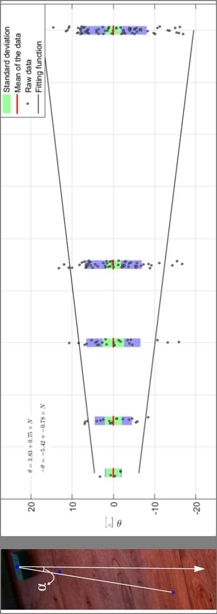
36 Non-Intrusive Debris Tracking Debris Spread Angle from centroid of initial position of container Increase in spreading angle with increase in debris Nistor et al. 2016, J. Waterway, Port, Coastal, Ocean Eng.

37 Optical Non-Intrusive Debris Tracking Based on image capture from motion Algorithm detects and tracks debris Color space conversion and color thresholding Kalman-filter and Hungarian algorithm Stolle et al. 2016, Resilient Infrastructure
38 Optical Non-Intrusive Debris Tracking Goseberg, 2016
39 Optical Non-Intrusive Debris Tracking Motion Stolle et al., 2016


40 Dam break test University of Ottawa Comprehensive experimental program using multiple debris events


41 Optical Non-Intrusive Debris Tracking Motion Examined a normal probability density function of the debris motion against longitudinal displacement Stolle et al., 2016 Within Naito et al. (2014) guidelines


42 Optical Non-Intrusive Debris Tracking Forces Stolle et al, 2016


43 Optical Non-Intrusive Debris Tracking Forces Tended to be single debris impacts Stolle et al, 2016

44 Research Program Numerical Modelling of Debris Motion

45 DualSPHyiscs Smoothed Particle Hydrodynamics Meshfree Lagrangian particle-based method Particles are represented by a set of arbitrarily distributed points The model uses a particle approximation to represent a function as the summation of all the particles within the influence domain
46 Debris motion SPH model Validation of water levels and velocity with experimental data Water level Velocity Goseberg & Nistor, 2016
47 Debris motion SPH model Simulating debris dynamics on a harbor apron 6 shipping containers, 3x2 side-by-side arrangement Model parameters: 9,788,181 particles Initial particle spacing d p = 0.5 mm Goseberg & Nistor, 2016
 (W1) (W5) (W6) (W7) (W8) (W9)")
48 SPH Debris Impact Ottawa U. (2014) (W1) (W5) (W6) (W7) (W8) (W9) Piche et al, 2014

49 Debris Impact SPH model Al-Feasly et al. (2013) Piche et al, 2014
50 Conclusions Current design documents for the estimation of tsunami impacts show deficiencies Tsunami field surveys provide unmatched opportunities for data collection to verify and improve existing formulations Debris accumulation occurs rapidly once structures are encountered. Design loads must consider debris damming and blockage Debris spreading appears to be dependent on the number of debris and its hydrodynamic condition Physical models showed that the increasing the amount of debris increased their spreading angle and decreased the length of their longitudinal displacement The presence of obstacles reduced the longitudinal displacement of the debris but did not impact the spreading angle


51 Acknowledgements Dan Palermo Ottawa U. Tomoya Shibayama Waseda U, Japan Tad Murty Ottawa U. Murat Saatcioglu Ottawa U. Graduate students at Ottawa U. Andrew Cornett Ottawa U. & NRC Nils Goseberg Ottawa U. & Hannover U. Philippe St-Germain, MASc Stephanie Piche, PhD Steven Douglas, PhD Taofiq Al-Faesly, PhD Jacob Stole, PhD Younes Nouri, MASc Safinaz El-Sohl, MASc

52 Thank you!
53 References Al-Faesly T., Nistor I., Palermo D., and Cornett A. (2013). "Experimental Study of Structures Subjected to Hydrodynamic and Debris Impact Forces." Canadian Society of Civil Engineers. ASCE/SEI (ASCE/Structural Engineering Institute). (2016). Minimum design loads for buildings and other structures. ASCE/SEI 7-16, Reston, VA. Eurode (2006). Actions on Structures Part 1-7: General Actions Accidental Actions. BS EN :2006. FEMA (2011). Coastal Construction Manual FEMA P55, Federal Emergency Management Agency. FEMA (2012). Guidelines for Design of Structures for Vertical Evacuation from Tsunamis- Second Edition. FEMA P646, Federal Emergency Management Agency Goseberg, N., Stolle, J., Nistor, I., and Shibayama, T. (2016). Experimental Analysis of Debris Motion due the Obstruction from Fixed Obstacles. Coastal Engineering, Elsevier, (accepted, in-press) Goseberg, N., Nistor, I., Mikami, T., Shibayama, T., Stolle, J. (2016). Non-Invasive Spatiotemporal smart debris Tracking in Turbulent Flows with Application to debris-laden Tsunami Inundation. J. of Hydraulic Eng., ASCE, Naito, C., Cercone, C., Riggs, H. R., and Cox, D. (2013). Procedure for site assessment of the potential for tsunami debris impact. J. of Waterway, Port, Coastal and Ocean Engineering, ASCE,140(2),
54 References Nistor, I., Goseberg, N., Mikami, T., Shibayama, T., Stolle, J., Nakamura, R., and Matsuba, S. (2016). Hydraulic Experiments on Debris Dynamics over a Horizontal Plane, J. of Waterway, Port, Coastal and Ocean Engineering, ASCE, (accepted, in press). Piche S., Nistor I., Murty T., (2014) Numerical Modeling of Debris Impacts Using the SPH Method. Coastal Engineering, ICCE Stolle, J., Nistor, I., and Goseberg, N. (2016). Optical Tracking of Floating Debris in a Wave Basin. Coastal Engineering Journal, JSCE, Stolle. J. Nistor, I., and Goseberg, N. (2016) Debris Dynamics and Impact Forces in Extreme Hydrodynamic Conditions, 7 th International Tsunami Symposium
 in rivers Automated tracking of coastal armour layers (e.")
55 Non-Intrusive Debris Tracking Smart Debris smart debris in action Accurate tracking positions of 9 shipping containers in a wave basin simultaneously Non-intrusive debris tracking II Tracking container rotation along vertical axis during flow Impact and potential future application Application to various other disciplines beyond civil engineering Tracking of floating objects (e.g. plastics, large wood debris) in rivers Automated tracking of coastal armour layers (e.g. tetrapods) Monitoring of transport user behaviour (e.g. pedestrians) Profiling of riparian fauna (e.g. in ecologic studies) Goseberg et al. (2016) Journal of Hydraulic Engineering
56 Development of a new Tsunami Loads and Effects Design Standard by ASCE No standard for engineering design for tsunami effects written in mandatory language exists. There is no comprehensive construction standard comparable to seismic or wind building codes for structures. The Tsunami Loads and Effects Subcommittee (TLESC) was established in February 2011 Chair: Gary CHOCK The of the ASCE/SEI 7 Standards Committee is developing a new Chapter 6 - Tsunami Loads and Effects, with Commentary, for the March 2016 Edition of the ASCE 7 Standard. Review by ASCE 7 Main Committee in Tsunami Provisions would then be referenced in the International Building Code IBC 2018
57 Outline of the New Design Method Probabilistic tsunami hazard analysis based criteria Energy-based methodology for calculating tsunami inundation depth and velocity at a site Structural loadings derived from research and validated Analysis techniques for determining building performance Multi-hazard performance-based approach for regions governed by local subduction earthquakes The proposed ASCE 7 provisions for Tsunami Loads and Effects are consistent with tsunami physics and performance based engineering, with substantial load validation from posttsunami case studies of structures.
58 Principal Tsunami Design Strategies Chapter 6 - Tsunami Loads and Effects Select a site appropriate and necessary for the building Select an appropriate structural system and perform seismic design first Determine flow depth and velocities at the site based on the tsunami design zone map Check robustness of expected strength within the inundation height to resist hydrodynamic forces Check resistance of lower elements for hydrodynamic pressures and debris impacts to avoid progressive collapse Foundations to resist scour at the perimeter of the building Elevate critical equipment as necessary
EXPERIMENTAL AND NUMERICAL SIMULATION OF TSUNAMI BORE IMPACT ON A BUILDING
 International Journal of Civil Engineering and Technology (IJCIET) Volume 7, Issue 4, July-August 216, pp. 13 23, Article ID: IJCIET_7_4_2 Available online at http://www.iaeme.com/ijciet/issues.asp?jtype=ijciet&vtype=7&itype=4
SCIENCE OF TSUNAMI HAZARDS
 SCIENCE OF TSUNAMI HAZARDS ISSN 8755-6839 Journal of Tsunami Society International Volume 32 Number 2 2013 IMPACT OF TSUNAMI FORCES ON STRUCTURES The University of Ottawa Experience D. Palermo, I. Nistor
Experimental Modelling of Debris Dynamics in Tsunami-Like Flow Conditions
 Experimental Modelling of Debris Dynamics in Tsunami-Like Flow Conditions Jacob Stolle Thesis submitted to the Faculty of Graduate and Postdoctoral Studies in partial fulfillment of the requirements for
RESILIENT INFRASTRUCTURE June 1 4, 2016
 RESILIENT INFRASTRUCTURE June 1 4, 2016 OPTICAL TRACKING OF DEBRIS IN EXTREME HYDRODYNAMIC CONDITIONS Jacob Stolle University of Ottawa, Canada Ioan Nistor University of Ottawa, Canada Nils Goseberg Institute
INERTIAL FORCES ON SHIPPING CONTAINERS FROM A BROKEN TSUNAMI BORE
 Proceedings of the 6 th International Conference on the Application of Physical Modelling in Coastal and Port Engineering and Science (Coastlab16) Ottawa, Canada, May 10-13, 2016 Copyright : Creative Commons
UNDERSTANDING TSUNAMI RISK TO STRUCTURES: A CANADIAN PERSPECTIVE
 UNDERSTANDING TSUNAMI RISK TO STRUCTURES: A CANADIAN PERSPECTIVE ABSTRACT : D. Palermo 1 and I. Nistor 1 1 Assistant Professor, Dept. of Civil Engineering, University of Ottawa, Ottawa, Canada Email: palermo@eng.uottawa.ca,
UNDERSTANDING TSUNAMI RISK TO STRUCTURES: A CANADIAN PERSPECTIVE
 UNDERSTANDING TSUNAMI RISK TO STRUCTURES: A CANADIAN PERSPECTIVE D. Palermo 1 and I. Nistor 1 1 Assistant Professor, Dept. of Civil Engineering, University of Ottawa, Ottawa, Canada Email: palermo@eng.uottawa.ca,
STUDY ON DRIFT BEHAVIOR OF CONTAINER ON APRON DUE TO TSUNAMI-INDUCED INCOMING AND RETURN FLOW
 STUDY ON DRIFT BEHAVIOR OF CONTAINER ON APRON DUE TO TSUNAMI-INDUCED INCOMING AND RETURN FLOW Tomoaki Nakamura 1, Norimi Mizutani 2 and Yasuhiro Wakamatsu 3 The drift behavior of a shipping container on
Available online at ScienceDirect. Procedia Engineering 116 (2015 )
") Available online at www.sciencedirect.com ScienceDirect Procedia Engineering 116 (2015 ) 422 427 8th International Conference on Asian and Pacific Coasts (APAC 2015) Department of Ocean Engineering, IIT
Available online at www.sciencedirect.com ScienceDirect Procedia Engineering 116 (2015 ) 422 427 8th International Conference on Asian and Pacific Coasts (APAC 2015) Department of Ocean Engineering, IIT
Tsunami Hydrodynamic Force on Various Bridge Sections
 Tsunami Hydrodynamic Force on Various Bridge Sections H. Nakao Public Works Research Institute, Japan K. Nozaka, K. Izuno & H. Kobayashi Ritsumeikan University, Japan SUMMARY: This paper discusses tsunami
Evaluation of tsunami force on concrete girder by experiment simulating steady flow
 Journal of Structural Engineering Vol.61A (March 215) JSCE Evaluation of tsunami force on concrete girder by experiment simulating steady flow Li Fu*, Kenji Kosa**, Tatsuo Sasaki*** and Takashi Sato****
Cascadia Seismic Event Planning for the Maritime Community
 Cascadia Seismic Event Planning for the Maritime Community Jonathan Allan, Oregon Dept. of Geology and Mineral Industries Presentation to Annual Pacific Northwest Waterways Association Meeting (PNWA) October
APPLICATON OF SEAMLESS SIMULATION OF SEISMIC RESPONSE ANALYSIS AND HIGH RESOLUTION TSUNAMI SIMULATION TO COASTAL AREA OF SENDAI
 Proceedings of the International Symposium on Engineering Lessons Learned from the 2011 Great East Japan Earthquake, March 1-4, 2012, Tokyo, Japan APPLICATON OF SEAMLESS SIMULATION OF SEISMIC RESPONSE
OUTLINE OF DAMAGE SURVEYS Surveyed areas Damage surveys were made in Tohoku area (from Hachinohe city in Aomori Prefecture to Soma city in Fukushima P
 Institute of Industrial Science, University of Tokyo Bulletin of ERS, No. 5 (1) TSUNAMI LOAD EVALUATION BASED ON DAMAGE OBSERVATION AFTER THE 11 GREAT EAST JAPAN EARTHQUAKE Tatsuya ASAI 1, Yoshiaki NAKANO
Large scale smooth particle hydrodynamics model for analytical fragility curves of a building subject to tsunami
 Large scale smooth particle hydrodynamics model for analytical fragility curves of a building subject to tsunami *Fritz Sihombing 1) and Marco Torbol 2) 1), 2) School of Urban and Environment Engineering,
Three Fs of earthquakes: forces, faults, and friction. Slow accumulation and rapid release of elastic energy.
 Earthquake Machine Stick-slip: Elastic Rebound Theory Jerky motions on faults produce EQs Three Fs of earthquakes: forces, faults, and friction. Slow accumulation and rapid release of elastic energy. Three
Earthquake Hazards. Tsunami
 Earthquake Hazards Tsunami Measuring Earthquakes Two measurements that describe the power or strength of an earthquake are: Intensity a measure of the degree of earthquake shaking at a given locale based
Earthquake Hazards. Tsunami
 Earthquake Hazards Tsunami Review: What is an earthquake? Earthquake is the vibration (shaking) and/or displacement of the ground produced by the sudden release of energy. The point inside the Earth where
Tsunami Load Evaluation Based on Field Investigations of the 2011 Great East Japan Earthquake
 Tsunami Load Evaluation Based on Field Investigations of the 11 Great East Japan Earthquake T. Asai & Y. Nakano T. Tateno The University of Tokyo, Japan Kajima Corporation, Japan H. Fukuyama K. Fujima
IG-WRDRR, UNESCAP, UNESCO-IOC, WMO. Yukio Tamura Chairman, International. Group. Tuesday 10 May, , Room 13. for Disaster. Risk.
 Side Event: Saving of Lives and Improved Coastal Risk Management through Regional Cooperation in Ocean and Marine Related Early Warning Systems in Asia Tuesday 10 May, 13.15 14.15, Room 13 IG-WRDRR, UNESCAP,
Lessons from the 2004 Sumatra earthquake and the Asian tsunami
 Lessons from the 2004 Sumatra earthquake and the Asian tsunami Kenji Satake National Institute of Advanced Industrial Science and Technology Outline 1. The largest earthquake in the last 40 years 2. Tsunami
We have previously looked at artificial seismograms such as this one here.
 We have previously looked at artificial seismograms such as this one here. S P A realistic Seismic Record Each vertical line = 1 minute Each horizontal line = 15 minutes Seismic station PMM is in Parkfield,
Developing fragility functions for tsunami damage estimation using the numerical model and satellite imagery
 Developing fragility functions for tsunami damage estimation using the numerical model and satellite imagery Shunichi KOSHIMURA 1 and Hideaki YANAGISAWA 2 1 Associate Professor, Disaster Control Research
Earthquake Hazards. Tsunami
 Earthquake Hazards Tsunami Review: What is an earthquake? Earthquake is the vibration (shaking) and/or displacement of the ground produced by the sudden release of energy. The point inside the Earth where
The EEFIT Mission to Japan after the M W 9.0 Tōhoku Earthquake: Key Findings and Lessons Learned
 The EEFIT Mission to Japan after the M W 9.0 Tōhoku Earthquake: Key Findings and Lessons Learned By A. Pomonis (Team Leader) Director, Cambridge Architectural Research, Ltd. on behalf of the EEFIT Mission
Response characteristics of R/C buildings considering impulsive force of tsunami drifting objects
 Response characteristics of R/C buildings considering impulsive force of tsunami drifting objects Ho CHOI 1, Kazuto MATSUKAWA 2 and Yoshiaki NAKANO 3 1 Research Associate, Institute of Industrial Science,
Outline of Guideline for Development and Utilization of Tsunami Disaster Management Map
 Outline of Guideline for Development and Utilization of Tsunami Disaster Management Map Port and Airport Research Institute, Japan The Overseas Coastal Area Development Institute of Japan Ports and Harbours
SMR/ May Simulation Analyses of Tsunami caused by Chilean and Nihon-Kai Chubu Earthquakes at Nuclear Power Plant Sites in Japan
 SMR/1839-2 Workshop on the Physics of Tsunami, Hazard Assessment Methods and Disaster Risk Management (Theories and Practices for Implementing Proactive Countermeasures) 14-18 May 2007 Simulation Analyses
History of International Training in Seismology and Earthquake Engineering at IISEE
 History of International Training in Seismology and Earthquake Engineering at IISEE Activities of International Institute of Seismology and Earthquake Engineering (IISEE), BRI - Training for young researchers/engineers
Wainui Beach Management Strategy (WBMS) Summary of Existing Documents. GNS Tsunami Reports
 Summary of Existing Documents. GNS Tsunami Reports") Wainui Beach Management Strategy (WBMS) Summary of Existing Documents GNS Tsunami Reports a) Review of Tsunami Hazard and Risk in New Zealand ( National Risk Report ) b) Review of New Zealand s Preparedness
Wainui Beach Management Strategy (WBMS) Summary of Existing Documents GNS Tsunami Reports a) Review of Tsunami Hazard and Risk in New Zealand ( National Risk Report ) b) Review of New Zealand s Preparedness
Tsunami. Harry Yeh Oregon State University. Eastern Japan Earthquake Disaster Briefing at PEER: April 28, 2011
 Tsunami by Harry Yeh Oregon State University Eastern Japan Earthquake Disaster Briefing at PEER: April 28, 2011 Seismic Characteristics Rupture Model (Harvard Seismology) The fault rupture process was
Introduction to Environmental Geology, 5e Case History: Indonesian Tsunami Indonesian Tsunami (2) Introduction Historic Tsunamis
 Introduction Historic Tsunamis") 1 2 3 4 5 6 7 8 9 Introduction to Environmental Geology, 5e Chapter 7 Tsunami Case History: Indonesian Tsunami December 26, 2004, within a few hours, close to 250,000 people were killed With no warning
1 2 3 4 5 6 7 8 9 Introduction to Environmental Geology, 5e Chapter 7 Tsunami Case History: Indonesian Tsunami December 26, 2004, within a few hours, close to 250,000 people were killed With no warning
Features of Tsunami height according to type of coastal landforms 2011 Tohoku oki tsunami case
 Features of Tsunami height according to type of coastal landforms 2011 Tohoku oki tsunami case (70 Nobuhisa Matta (Disaster Mitigation Research Center Nagoya Univ.) July 3 rd, 2013, at Taipei Outline +
RECENT PROGRESS OF PHYSICAL MODELING BASED ON FIELD INVESTIGATIONS OF TSUNAMIS AND STORM SURGES
 Proceedings of the 6 th International Conference on the Application of Physical Modelling in Coastal and Port Engineering and Science (Coastlab16) Ottawa, Canada, May 10-13, 2016 Copyright : Creative Commons
How to communicate Cascadia Subduction Zone earthquake hazards
 How to communicate Cascadia Subduction Zone earthquake hazards Tom Brocher Research Geophysicist Earthquake Science Center U.S. Geological Survey Menlo Park, California Seattle Post-Intelligencer Lessons
Geospatial application in Kiribati
 Geospatial application in Kiribati ICC-21 ST RESAP (9 TH TO 13 TH OCTOBER, 2017) BANGKOK, THAILAND Outline Kiribati Profile Natural disasters in Kiribati Achievements Challenges/Issues Ways forward 1 Kiribati
COASTAL ENGINEERING 2016 A PREDICTIVE MODEL FOR SCOUR DEPTH OF COASTAL BUILDING FAILURES DUE TO TSUNAMIS
 A PREDICTIVE MODEL FOR SCOUR DEPTH OF COASTAL BUILDING FAILURES DUE TO TSUNAMIS Mara Nicholas 1, Ravindra Jayaratne 2, Takayuki Suzuki 3 and Tomoya Shibayama 4 The 2011 Great East Japan Earthquake and
Numerical Modeling of Tsunami Bore Attenuation and Extreme Hydrodynamic Impact Forces Using the SPH Method
 Numerical Modeling of Tsunami Bore Attenuation and Extreme Hydrodynamic Impact Forces Using the SPH Method Steffanie Piché Thesis submitted to the Faculty of Graduate and Postdoctoral Studies In partial
INFLUENCE OF A INFRASTRUCTURE ON TSUNAMI INUNDATION IN A COASTAL CITY: LABORATORY EXPERIMENT AND NUMERICAL SIMULATION
 INFLUENCE OF A INFRASTRUCTURE ON TSUNAMI INUNDATION IN A COASTAL CITY: LABORATORY EXPERIMENT AND NUMERICAL SIMULATION Sungwon Shin 1, Kwang-Ho Lee 1, Hyungsu Park 2, Daniel T. Cox 2, Kyuhan Kim 1 Laboratory
JETT Mulyo Harris Pradono
 Japan Earthquake and Tsunami Team JETT Mulyo Harris Pradono Rudi Kurniawan (Syiah Kuala University) Main Earthquake and Sequence of Aftershocks 02:22:01UTC M5.8 8.85N 92.42E 02:15:59UTC M5.7 12.33N 92.48E
TSUNAMI LOAD EVALUATION BASED ON DAMAGE OBSERVATION AFTER THE 2011 GREAT EAST JAPAN EARTHQUAKE
 Proceedings of the International Symposium on Engineering Lessons Learned from the 11 Great East Japan Earthquake, March 1-, 1, Tokyo, Japan TSUNAMI LOAD EVALUATION BASED ON DAMAGE OBSERVATION AFTER THE
Fluid-soil multiphase flow simulation by an SPH-DEM coupled method
 Fluid-soil multiphase flow simulation by an SPH-DEM coupled method *Kensuke Harasaki 1) and Mitsuteru Asai 2) 1), 2) Department of Civil and Structural Engineering, Kyushu University, 744 Motooka, Nishi-ku,
Introduction to Environmental Geology, 5e
 Lecture Presentation prepared by X. Mara Chen, Salisbury University Introduction to Environmental Geology, 5e Edward A. Keller Chapter 7 Tsunami Case History: Indonesian Tsunami December 26, 2004, within
Structures Group Report
 Structures Group Report Ian Buckle, Co-leader University of Nevada Reno Kazuhiko Kawashima, Co-leader Tokyo Institute of Technology J-RAPID Final Symposium, Sendai, March 6-7, 2013 Structures Presentations
Surviving Tsunamis on the Oregon Coast
 Slide 1 Surviving Tsunamis on the Oregon Coast Coastal Engineers Think Inside the Box This talk generally covers civil engineering, coastal engineering, and how engineers work within limitations to create
Integrated Approach to Assess the Impact of Tsunami Disaster
 Integrated Approach to Assess the Impact of Tsunami Disaster Shunichi Koshimura & Shintaro Kayaba Disaster Control Research Center, Graduate School of Engineering, Tohoku University, Japan Masashi Matsuoka
UGRC 144 Science and Technology in Our Lives/Geohazards
 UGRC 144 Science and Technology in Our Lives/Geohazards Session 3 Understanding Earthquakes and Earthquake Hazards Lecturer: Dr. Patrick Asamoah Sakyi Department of Earth Science, UG Contact Information:
Experimental Study for Investigating the Impact Force on a Wooden House by Driftwood in Steady and Unsteady Surge-type Flow
 Experimental Study for Investigating the Impact Force on a Wooden House by Driftwood in Steady and Unsteady Surge-type Flow K. Miyahara 1 and N. Tanaka 2 1 Graduate School of Science and Engineering, Saitama
Education and Drill Activities against Tsunami Disasters in Chile and Japan -WG4a Activities-
 Education and Drill Activities against Tsunami Disasters in Chile and Japan -WG4a Activities- Dr. F. Miura, Yamaguchi U., Mr. M. Reyes, UV MSc. O. Cifuentes, UDEC, Enhancement of Technology to Develop
Predicting of Tsunami Inundation Area based on Propagation and Runup Numerical Model in Pacitan City
 Predicting of Tsunami Inundation Area based on Propagation and Runup Numerical Model in Pacitan City 1 Agus Suharyanto, 1 Alwafi Pujiraharjo, 2 Adipandang Yudono, 3 Keisuke Murakami, and 3 Chikashi Deguchi
BRIDGE DAMAGE SURVEY IN BANDA ACEH AND SURROUNDING AREAS AND EARTHQUAKE AND TSUNAMI QUESTIONNAIRES
 4th International Conference on Earthquake Engineering Taipei, Taiwan October 12-13, 2006 Paper No. 276 BRIDGE DAMAGE SURVEY IN BANDA ACEH AND SURROUNDING AREAS AND EARTHQUAKE AND TSUNAMI QUESTIONNAIRES
Seismic Activity and Crustal Deformation after the 2011 Off the Pacific Coast of Tohoku Earthquake
 J-RAPID Symposium March 6-7, 2013 Seismic Activity and Crustal Deformation after the 2011 Off the Pacific Coast of Tohoku Earthquake Y. Honkura Tokyo Institute of Technology Japan Science and Technology
RESPONSE OF STRUCTURES AGAINST TSUNAMI FORCES UNDER DIFFERENT SOIL CONDITIONS
 VOL. 13, NO. 11, JUNE 218 ISSN 1819-668 26-218 Asian Research Publishing Network (ARPN). All rights reserved. RESPONSE OF STRUCTURES AGAINST TSUNAMI FORCES UNDER DIFFERENT SOIL CONDITIONS A. H. L.Swaroop
at IHO IRCC7 Mexico City, Mexico, June 2015
 Report on Japan s Response to Disasters presented by JHOD at IHO IRCC7 Mexico City, Mexico, 01 03 June 2015 JAPAN COAST GUARD Actions against huge earthquake Actions taken by JHOD against the Great East
Risk-based land use and spatial planning
 Risk-based land use and spatial planning Miho OHARA International Centre for Water Hazards and Risk Management (ICHARM) Public Works Research Institute PWRI), Japan Under the auspices of UNESCO Introduction
NUMERICAL ANALYSIS OF TSUNAMI FLOW AROUND COASTAL DYKE
 Proceedings of the 7 th International Conference on Asian and Pacific Coasts (APAC 2013) Bali, Indonesia, September 24-26, 2013 NUMERICAL ANALYSIS OF TSUNAMI FLOW AROUND COASTAL DYKE T. Mikami 1 and T.
Prevention Tsunami wall 10m high (breached by the tsunami due to land level falling by 3m)
") Plate margin Plates Causes Sendai, Japan Convergent plate margin Pacific and Eurasian Plates Convergent plate margin Sima (Pacific plate) moves towards the sial (Eurasian plate) Sima (Pacific plate) is
Plate margin Plates Causes Sendai, Japan Convergent plate margin Pacific and Eurasian Plates Convergent plate margin Sima (Pacific plate) moves towards the sial (Eurasian plate) Sima (Pacific plate) is
Flood Management in Japan
 Flood Management in Japan 1. Comprehensive Flood Control Measures 2. Provision of River information 3. Responses to the Niigata Torrential Rain Disaster 4. About ICHARM 5. Responses to 2011 Thailand Floods
(energy loss is greater with longer wavelengths)
") GEOL 0820 Ramsey Natural Disasters Spring, 2018 LECTURE #9: Tsunami Monitoring & Mitigation Date: 8 February 2018 I. Characteristics (con t): shoaling: o process of wave height increase and breaking as
GEOL 0820 Ramsey Natural Disasters Spring, 2018 LECTURE #9: Tsunami Monitoring & Mitigation Date: 8 February 2018 I. Characteristics (con t): shoaling: o process of wave height increase and breaking as
LOCAL TSUNAMIS: CHALLENGES FOR PREPAREDNESS AND EARLY WARNING
 LOCAL TSUNAMIS: CHALLENGES FOR PREPAREDNESS AND EARLY WARNING HARALD SPAHN 1 1 German Technical Cooperation International Services, Jakarta, Indonesia ABSTRACT: Due to the threat of local tsunamis warning
- Information before strong ground motion -
 -Earthquake Early Warning - Information before strong ground motion - Mitsuyuki HOSHIBA Japan Meteorological Agency January 12, 2007 1 Distribution of Earthquakes Causing Tsunami (1896~2004) in Japan Distribution
Development of Spatial Information Database of Building Damage and Tsunami Inundation Areas following the 2010 Chile Earthquake
 Development of Spatial Information Database of Building Damage and Tsunami Inundation Areas following the 2010 Chile Earthquake Fumio YAMAZAKI 1, Yoshihisa MARUYAMA 2, Hiroyuki MIURA 3, Shizuko MATSUZAKI
The Role of Science and Technology in Earthquake Hazard Characterization: A Chilean Experience
 The Role of Science and Technology in Earthquake Hazard Characterization: A Chilean Experience STI Contribution to Policy Making on Natural Disaster Resilience APEC Workshop, 1-2 August 2018 Santiago -
Lessons Learned from Past Tsunamis Warning and Emergency Response
 UNESCO IOC CTIC US NOAA ITIC Regional Training Workshop on Strengthening Tsunami Warning and Emergency Response Standard Operating Procedures and the Development of the ICG/CARIBE-EWS PTWC New Enhanced
Tsunami Load Determination for On-Shore Structures. Harry Yeh Oregon State University
 Tsunami Load Determination for On-Shore Structures Harry Yeh Oregon State University Building survival Vertical Evacuation to Tsunami Shelters How can we estimate the tsunami forces on such onshore structures?
Training System and Information Network for Earthquake Disaster Mitigation. Taiki SAITO. Building Research Institute (BRI)
") 1 Training System and Information Network for Earthquake Disaster Mitigation Taiki SAITO Chief Research Engineer, International Institute of Seismology and Earthquake Engineering (IISEE), Building Research
1 Training System and Information Network for Earthquake Disaster Mitigation Taiki SAITO Chief Research Engineer, International Institute of Seismology and Earthquake Engineering (IISEE), Building Research
2016 Kaikoura Earthquake (NZ) Effects & Phenomena. Trevor Matuschka With special acknowledgement Dan Forster (Damsafety Intelligence)
 Effects & Phenomena. Trevor Matuschka With special acknowledgement Dan Forster (Damsafety Intelligence)") 2016 Kaikoura Earthquake (NZ) Effects & Phenomena Trevor Matuschka With special acknowledgement Dan Forster (Damsafety Intelligence) Contents 1. Kaikoura Earthquake where and what happened 2. Seismic and
2016 Kaikoura Earthquake (NZ) Effects & Phenomena Trevor Matuschka With special acknowledgement Dan Forster (Damsafety Intelligence) Contents 1. Kaikoura Earthquake where and what happened 2. Seismic and
Tsunami Risk Mitigation Strategy for Thailand. Kjell Karlsrud Norwegian Geotechnical Institute (NGI)
") Tsunami Risk Mitigation Strategy for Thailand Kjell Karlsrud Norwegian Geotechnical Institute (NGI) The project was undertaken by NGI in cooperation with: NORSAR, UiB, UiO, NIBR, B.Heyerdahl, NTNU, Sintef
Tsunami Risk Mitigation Strategy for Thailand Kjell Karlsrud Norwegian Geotechnical Institute (NGI) The project was undertaken by NGI in cooperation with: NORSAR, UiB, UiO, NIBR, B.Heyerdahl, NTNU, Sintef
DEVELOPMENT OF TSUNAMI DESIGN CRITERIA FOR OREGON COASTAL BRIDGES. Bruce Johnson 1 Based on research and documents by Solomon Yim 2 et al
 DEVELOPMENT OF TSUNAMI DESIGN CRITERIA FOR OREGON COASTAL BRIDGES Bruce Johnson 1 Based on research and documents by Solomon Yim 2 et al Abstract This paper describes Oregon Department of Transportation
Damage Estimation of the Road Bridge Structure Using the Seismic Hazard map for BCM in Hokkaido, Japan
 Damage Estimation of the Road Bridge Structure Using the Seismic Hazard map for BCM in Hokkaido, Japan T. Sato & H. Nishi Civil Engineerring Research Institute for Cold Region, PWRI,Japan T. Ikeda & Y.
Earthquake hazards. Aims 1. To know how hazards are classified 2. To be able to explain how the hazards occur 3. To be able to rank order hazards
 Earthquake hazards Aims 1. To know how hazards are classified 2. To be able to explain how the hazards occur 3. To be able to rank order hazards Types of hazard Primary A direct result of the earthquake
Natural Hazards Large and Small
 Specialty Seminar on Engineering of Geo-Hazards ASCE Met Section Geotechnical Group and Geo-Institute of ASCE 16 May 2007 Natural Hazards Large and Small Evaluation and Mitigation Edward Kavazanjian, Jr.,
GEO-VIII November Geohazard Supersites and Natural Laboratories Progress Report. Document 9
 GEO-VIII 16-17 November 2011 Geohazard Supersites and Natural Laboratories Progress Report Document 9 This document is submitted to GEO-VIII for information. Geohazard Supersites and Natural Laboratories
The Challenge of Earthquake Disaster in Indonesia. Hery Harjono Indonesian Institute of Sciences
 The Challenge of Earthquake Disaster in Indonesia Hery Harjono Indonesian Institute of Sciences * Presented at the J-Rapid Symposium, Sendai, Japan, March 6-7, 2013 INTRODUCTION The 2004 Giant Sumatran-Andaman
Interpretive Map Series 24
 Oregon Department of Geology and Mineral Industries Interpretive Map Series 24 Geologic Hazards, and Hazard Maps, and Future Damage Estimates for Six Counties in the Mid/Southern Willamette Valley Including
NPTEL Video Course on Geotechnical Earthquake Engineering
 NPTEL Video Course on Geotechnical Earthquake Engineering by Prof. Deepankar Choudhury Professor, Dept. of Civil Engg., Indian Institute of Technology (IIT) Bombay Powai, Mumbai 400076, India. Email: dc@civil.iitb.ac.in
REAL-TIME TSUNAMI INUNDATION PREDICTION USING OFFSHORE TSUNAMI OBSERVATION. Daisuke TATSUMI 1 and Takashi TOMITA 1
 REAL-TIME TSUNAMI INUNDATION PREDICTION USING OFFSHORE TSUNAMI OBSERVATION Daisuke TATSUMI and Takashi TOMITA The previous real-time tsunami prediction based on the inversion method and the linear superposition
4-3-1 Earthquake and Tsunami Countermeasures of Tokyo s
 4-3-1 Earthquake and Tsunami Countermeasures of Tokyo s Sewerage Masahiro Hikino* and Gaku Sato** *Planning Section, Planning and Coordinating Division, Bureau of Sewerage, Tokyo Metropolitan Government
THE ROLE OF URBAN DEVELOPMENT PATTERNS IN MITIGATING THE EFFECTS OF TSUNAMI RUN- UP
 SS2-Fri-1 The 14th Japan Earthquake Engineering Symposium (2014) THE ROLE OF URBAN DEVELOPMENT PATTERNS IN MITIGATING THE EFFECTS OF TSUNAMI RUN- UP Ronald EGUCHI 1, Michael EGUCHI 2, Shunichi KOSHIMURA
Source region of the earthquake
 Disasters of port facilities due to 2011 Great East Japan Earthquake Yoshiaki Kikuchi Port & Airport Research Institute Contents Outline of the earthquake Measured Tsunami height Breakwater disasters by
I. Locations of Earthquakes. Announcements. Earthquakes Ch. 5. video Northridge, California earthquake, lecture on Chapter 5 Earthquakes!
 51-100-21 Environmental Geology Summer 2006 Tuesday & Thursday 6-9:20 p.m. Dr. Beyer Earthquakes Ch. 5 I. Locations of Earthquakes II. Earthquake Processes III. Effects of Earthquakes IV. Earthquake Risk
crustal structure experiment beneath Wairarapa - Wellington area: results from SAHKE
 crustal structure experiment beneath Wairarapa - Wellington area: results from SAHKE Tim Stern and SAHKE team* * VUW, GNS, University of Southern California, University of Tokyo(Japan) SAHKE = Seismic
KNOWLEDGE NOTE 5-1. Risk Assessment and Hazard Mapping. CLUSTER 5: Hazard and Risk Information and Decision Making. Public Disclosure Authorized
 Public Disclosure Authorized Public Disclosure Authorized Public Disclosure Authorized Public Disclosure Authorized KNOWLEDGE NOTE 5-1 CLUSTER 5: Hazard and Risk Information and Decision Making Risk Assessment
Important Concepts. Earthquake hazards can be categorized as:
 Lecture 1 Page 1 Important Concepts Monday, August 17, 2009 1:05 PM Earthquake Engineering is a branch of Civil Engineering that requires expertise in geology, seismology, civil engineering and risk assessment.
RISK ASSESSMENT COMMUNITY PROFILE NATURAL HAZARDS COMMUNITY RISK PROFILES. Page 13 of 524
 RISK ASSESSMENT COMMUNITY PROFILE NATURAL HAZARDS COMMUNITY RISK PROFILES Page 13 of 524 Introduction The Risk Assessment identifies and characterizes Tillamook County s natural hazards and describes how
Forecasting Damage Length of Maritime Structures Caused by Typhoons Based on Improved EWE Method
 Forecasting Damage Length of Maritime Structures Caused by Typhoons Based on Improved EWE Method R. Hashimura Abstract The aim is to forecast the damage length of damaged maritime structures at each coast
INFLUENCE OF TSUNAMI INDUCED SCOURING ACTION ON FOUNDATION STABILITY OF COASTAL STRUCTURES
 International Journal of Civil Engineering and Technology (IJCIET) Volume 9, Issue 7, July 2018, pp. 889 894, Article ID: IJCIET_09_07_093 Available online at http://www.iaeme.com/ijciet/issues.asp?jtype=ijciet&vtype=9&itype=7
Sendai Earthquake NE Japan March 11, Some explanatory slides Bob Stern, Dave Scholl, others updated March
 Sendai Earthquake NE Japan March 11, 2011 Some explanatory slides Bob Stern, Dave Scholl, others updated March 14 2011 Earth has 11 large plates and many more smaller ones. Plates are 100-200 km thick
Earthquakes. Earthquake Magnitudes 10/1/2013. Environmental Geology Chapter 8 Earthquakes and Related Phenomena
 Environmental Geology Chapter 8 Earthquakes and Related Phenomena Fall 2013 Northridge 1994 Kobe 1995 Mexico City 1985 China 2008 Earthquakes Earthquake Magnitudes Earthquake Magnitudes Richter Magnitude
ANALYSIS OF EVACUATION BEHAVIORS IN DIFFERENT AREAS BEFORE AND AFTER THE GREAT EAST JAPAN EARTHQUAKE
 Fifth International Conference on Geotechnique, Construction Materials and Environment, Osaka, Japan, Nov. 16-18, 2015, ISBN: 978-4-9905958-4-5 C3051 ANALYSIS OF EVACUATION BEHAVIORS IN DIFFERENT AREAS
Publishable Summary. Summary Description of the project context and main objectives
 Publishable Summary Summary Description of the project context and main objectives Tsunamis are low frequency but high impact natural disasters. In 2004, the Boxing Day tsunami killed hundreds of thousands
DRAFT - Tsunami Response Plan Playbook Santa Cruz Harbor Maritime Community
 DRAFT - Tsunami Response Plan Playbook Santa Cruz Harbor Maritime Community Page 1 Best to display on 11X17 paper Purpose and Use of this Real-time Tsunami Response Plan Playbook PURPOSE: This product
DATA BASE DEVELOPMENT OF ETA (ESTIMATED TIME OF ARRIVAL) FOR TSUNAMI DISASTER MITIGATION AT SOUTHWESTERN CITIES OF ACEH, INDONESIA
 FOR TSUNAMI DISASTER MITIGATION AT SOUTHWESTERN CITIES OF ACEH, INDONESIA") 6 th South China Sea Tsunami Workshop Nanyang Technology University, Singapore, 6-8 November 2013 DATA BASE DEVELOPMENT OF ETA (ESTIMATED TIME OF ARRIVAL) FOR TSUNAMI DISASTER MITIGATION AT SOUTHWESTERN
6 th South China Sea Tsunami Workshop Nanyang Technology University, Singapore, 6-8 November 2013 DATA BASE DEVELOPMENT OF ETA (ESTIMATED TIME OF ARRIVAL) FOR TSUNAMI DISASTER MITIGATION AT SOUTHWESTERN
Tsunami and earthquake in Chile Part 2
 EUROPEAN COMMISSION DIRECTORATE GENERAL JRC JOINT RESEARCH CENTRE Institute for the Protection and Security of the Citizen Global Security and Crisis Management Unit CriTech Sunday, 28 February 2010 Executive
Wind Tower Deployments and Pressure Sensor Installation on Coastal Houses Preliminary Data Summary _ Sea Grant Project No.
 Wind Tower Deployments and Pressure Sensor Installation on Coastal Houses Preliminary Data Summary _ Sea Grant Project No.:1020040317 Submitted to: South Carolina Sea Grant Consortium 287 Meeting Street
Strategic approach towards Post Tsunami Mitigation and Conservation of the Sri Lankan coastline
 Strategic approach towards Post Tsunami Mitigation and Conservation of the Sri Lankan coastline Dr. S.S.L.Hettiarachchi Dr. S.P.Samarawickrama University of Moratuwa Illustrated via a Case Study for the
Overflow Pattern and the Formation of Scoured Region by the Tsunami Propagated in River Channels in Great East Japan Earthquake
 Overflow Pattern and the Formation of Scoured Region by the Tsunami Propagated in River Channels in Great East Japan Earthquake N. Tanaka 1, 2, J. Yagisawa 1, 2 and S. Yasuda 2 1 Institute for Environmental
Overview of Consequences of the Tsunami in Thailand and Roles and Activities of the Department of Mineral Resources after the 26 December 2004 Tsunami
 Overview of Consequences of the Tsunami in Thailand and Roles and Activities of the after the 26 December 2004 Tsunami By Mr.Worawoot Tantiwanit, Thailand 1 Earthquake in NW of North Sumatra Island 580
Numerical Modeling of Extreme Flow Impacts on Structures
 Numerical Modeling of Extreme Flow Impacts on Structures Nora Asadollahi Shahbaboli Thesis submitted to the Faculty of Graduate and Postdoctoral Studies in partial fulfillment of the requirements for the
Comparative Analysis of Hurricane Vulnerability in New Orleans and Baton Rouge. Dr. Marc Levitan LSU Hurricane Center. April 2003
 Comparative Analysis of Hurricane Vulnerability in New Orleans and Baton Rouge Dr. Marc Levitan LSU Hurricane Center April 2003 In order to compare hurricane vulnerability of facilities located in different