JETT Mulyo Harris Pradono
|
|
|
- Dinah Andrews
- 5 years ago
- Views:
Transcription
1 Japan Earthquake and Tsunami Team JETT Mulyo Harris Pradono Rudi Kurniawan (Syiah Kuala University)

2 Main Earthquake and Sequence of Aftershocks 02:22:01UTC M N 92.42E 02:15:59UTC M N 92.48E 02:15:50UTC M N 92.19E 02:00:40UTC M N 94.61E 01:59:14UTC M N 92.43E 01:40:07UTC M N 93.03E 01:22:27UTC M N 93.72E 01:21:26UTC M N 93.35E 01:25:49UTC M N 94.17E 01:48:49UTC M N 94.42E 00:58:53UTC M N 95.55E Source: USGS
 in parts of Bangladesh, India, Malaysia, Maldives, Myanmar, Singapore, Sri Langka, and Thailand.")
3 Intensities The earthquake was felt (VIII) at Banda Aceh and (V) at Medan, Sumatra. It was felt (II-IV) in parts of Bangladesh, India, Malaysia, Maldives, Myanmar, Singapore, Sri Langka, and Thailand. Subsidence and landslides were observed in Sumatra Source: USGS Earthquake Hazard Program ws/2004/usslav

4 Source: Digital Globe Analysis Digital Globe Analysis Grand Mosque

5 Buildings Near Grand Mosque Satellite Photo December 28, 2004 Visited Buildings Grand Mosque Source: Digital Globe Analysis


 Severe cracking")

6 Baiturrahman Grand Mosque Survey March 02, 2004 Main Tower (east of main build.) Severe cracking and spalling of concrete Tsunami flood about 80 cm


7 Baiturrahman Grand Mosque Survey March 02, 2004 Non-structural column Structural column


8 Baiturrahman Grand Mosque Survey March 02, 2004 Elevator structure inside the tower


9 Baiturrahman Grand Mosque Survey March 02, 2004 Main Building (west of main tower) Older building 1875 Newer building 1962 Crack


10 Nearby Buildings March 02, 2005

 The hotel")

11 Nearby Buildings March 02, 2005 (Kuala Tripa Hotel) The hotel was expanded from a 4-story hotel to a 5-story hotel

 After the")

12 Nearby Buildings March 02, 2005 (Kuala Tripa Hotel) After the earthquake, one lower story was collapsed


")
13 Nearby Buildings March 02, 2005 (Water Tower)

14
15 1979 Syiah Kuala

16
17 Banda Aceh H Grand Mosque 7 4 A C (Jl. Mohammad Daud Beureueh D G
18 Banda Aceh A: 5.56 B: 5.48 C: 5.52 D: 5.49 E: 5.51 F: 5.79 G: 5.36 H: 5.60 I: 4.92
 B: 10m(1), 30m(2), 20m(3) C: 3m(1), 5m(2) D: 7m(1), 10m(2) E: 1m(1), 4m(2),")
19 Banda Aceh A: 1.5m(1 ), 2.5m(2 ) B: 10m(1), 30m(2), 20m(3) C: 3m(1), 5m(2) D: 7m(1), 10m(2) E: 1m(1), 4m(2), 10m(3) F: 8m(1), 8m(2) G: 20m(1), 30m(2) H: 1m(1) I: 10m(1), 15m(2)
20 No Yes (39), (9), No (16) (14), (12), (10), (6), (5)
21
22 STRUCTURE AND INFRASTRUCTURE SURVEY IN BANDA ACEH Japan Earthquake and Tsunami Team JETT Hirokazu IEMURA Yoshikazu TAKAHASHI Mulyo Harris Pradono Graduate School of Civil Engineering Kyoto University, Kyoto, Japan

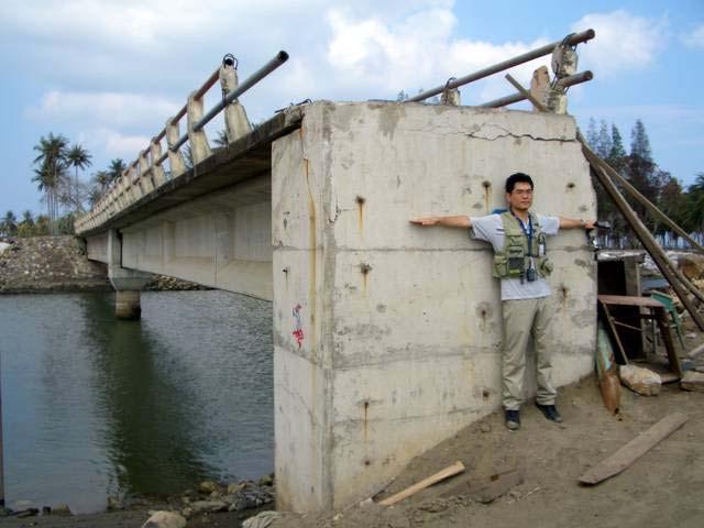
23 North Two of the surveyed bridges, March 2005 No.1 Asoe Nanggroe No.20 Peukan Bada Satellite photo December 29, 2004 Photo Source: Digital Globe
24 North Two span bridge supported by RC girders Concrete crushing (a) (b) (c) 720 cm 140 cm 23 cm 100 cm 26 cm 720 cm 76 cm 85 cm South Scouring at approach 2540 cm Bridge No.1 Asoe Nanggroe (Dimensions and Displacements)
25 95 cm North 17 cm One span bridge supported by RC girders 530 cm (a) (b) 2680 cm 18 cm 165 cm South 94 cm 20 cm 42 cm 530 cm 72 cm 70 cm 30 cm 45 cm (c) Bridge No.20 Peukan Bada (Dimensions and Displacements)
26 Estimated water velocity that causes bridge to move Area of attack, A = m 2 Case Study: No.20 Peukan Bada Bridge Mass of 3 girders + 1 deck, m = 227,264 kg Weight, W = m g = 2,227,187 Newton g = 9.8 m/s 2 Resisting force, F f = W = 668,156 Newton = 0.3 m/s 2 Fluid drag force, F d = 0.5 C d v 2 A = F f (bridge start moving) v = 2F ρc d f A = 2 668, = 3.71 m/s 13.4 km/h
27 Estimated water velocity that causes bridge to move Previous calculation did not consider water uplift force Case Study: No.20 Peukan Bada Bridge Considering water uplift force, the velocity is calculated as: v wu = = 10.4 km/h
28 Next Research To calculate water-dragging velocities for other bridges Recommendations for tsunami-prone bridges Publications

29 Bridge No.1 Asoe Nanggroe March 04, 2005 South 85 cm Displacement of Deck to Upstream Direction

")
30 Bridge No.1 Asoe Nanggroe March 04, 2005 Upstream Downstream (photo from Northern Abutment) (photo from Southern Abutment) Displacement of Decks to Upstream Direction

 (Crushing")
31 Bridge No.1 Asoe Nanggroe March 04, 2005 Downstream Upstream 23 cm (Gap between decks at the upstream side) (Crushing of deck concrete at the downstream side)

 (Scouring")
32 Bridge No.1 Asoe Nanggroe March 04, 2005 Downstream Downstream (Scouring at Southern Approach) (Scouring at Northern Approach)

33 Bridge No.20 Peukan Bada March 04, 2005 North Upstream Downstream One-span Peukan Bada Bridge (photo facing the north)

34

35
36

37

38

39

40 Meulaboh from Helicopter March 03, 2005 Before boarding


41 Meulaboh from Helicopter March 03, 2005 On board

42 Meulaboh from Helicopter March 03, 2005 On the way

43 Meulaboh from Helicopter March 03, 2005 On the way

44 Meulaboh from Helicopter March 03, 2005

45 Meulaboh from Helicopter March 03, 2005

46 Meulaboh from Helicopter March 03, 2005

47 Meulaboh from Helicopter March 03, 2005

48 Meulaboh from Helicopter March 03, 2005 On the way back

49 Heavily damaged Cement Factory, March 03, 2005


50 Cement Factory, Satellites Photos Photo Source: Digital Globe January 10, 2003 December 29, 2004

51 Cement Factory, March 03, 2005 Heavily Scoured

52 Cement Factory, March 03, 2005 Heavily damaged conveyor belt

53 Cement Factory, March 03, 2005 Intact Silos

54 Cement Factory, March 03, 2005 Damaged by tsunami instead of earthquake


55 Cement Factory, March 03, 2005 Two different failure mechanisms Static loading Cyclic loading

56 Khao Lak, Thailand, March 09, 2005

57 Khao Lak, Thailand, March 09, 2005
Report on the Tsunami Damage of Bridges in Banda Aceh and Some Possible Countermeasures
 Proc. 8th JSCE Earthquake Engineering Symposium,005 Report on the Tsunami Damage of Bridges in Banda Aceh and Some Possible Countermeasures Hirokazu IEMURA 1 Mulyo Harris Pradono Yoshikazu TAKAHASHI 3
Chapter 6. Strong Motions
 Chapter 6 Strong Motions In spite of the scale of this earthquake, there is unfortunately no strong motion record nearby the causative fault. The nearest seismograph is approximately 80km from the epicenter
BRIDGE DAMAGE SURVEY IN BANDA ACEH AND SURROUNDING AREAS AND EARTHQUAKE AND TSUNAMI QUESTIONNAIRES
 4th International Conference on Earthquake Engineering Taipei, Taiwan October 12-13, 2006 Paper No. 276 BRIDGE DAMAGE SURVEY IN BANDA ACEH AND SURROUNDING AREAS AND EARTHQUAKE AND TSUNAMI QUESTIONNAIRES
Evaluation of the Structural Fragility of a Bridge Structure Subjected to a Tsunami Wave Load
 Journal of Natural Disaster Science, Volume 9, Number, 007, pp73-81 73 Evaluation of the Structural Fragility of a Bridge Structure Subjected to a Tsunami Wave Load Gaku SHOJI and Tetsuo MORIAMA Department
28 th March 2005 magnitude 8.7 earthquake Northern Sumatra, Indonesia
 29 th March 2005 GAPResponse 28 th March 2005 magnitude 8.7 earthquake Northern Sumatra, Indonesia Russell Blong T: +61 2 8209 4288 F: +61 2 9241 2441 E: russell.blong@benfieldgroup.com Ben Miliauskas
Lessons from the 2004 Sumatra earthquake and the Asian tsunami
 Lessons from the 2004 Sumatra earthquake and the Asian tsunami Kenji Satake National Institute of Advanced Industrial Science and Technology Outline 1. The largest earthquake in the last 40 years 2. Tsunami
Tsunami Hydrodynamic Force on Various Bridge Sections
 Tsunami Hydrodynamic Force on Various Bridge Sections H. Nakao Public Works Research Institute, Japan K. Nozaka, K. Izuno & H. Kobayashi Ritsumeikan University, Japan SUMMARY: This paper discusses tsunami
What is an earthquake?
 Earthquakes Definitions Seismology The study of earthquakes dates back almost 2000 years to the Chinese Fault A crack in the Earth along which movement or sliding occurs What is an earthquake? Focus vs.
Predicting Tsunami Inundated Area and Evacuation Road Based On Local Condition Using GIS
 IOSR Journal of Environmental Science, Toxicology and Food Technology (IOSR-JESTFT) ISSN: 2319-2402, ISBN: 2319-2399. Volume 1, Issue 4 (Sep-Oct. 2012), PP 05-11 Predicting Tsunami Inundated Area and Evacuation
We have previously looked at artificial seismograms such as this one here.
 We have previously looked at artificial seismograms such as this one here. S P A realistic Seismic Record Each vertical line = 1 minute Each horizontal line = 15 minutes Seismic station PMM is in Parkfield,
Satellite Observations of the Great Mega Thrust Sumatra Earthquake Activities
 International Journal of Geoinformatics, Vol. 1, No. 4, December 2005 Satellite Observations of the Great Mega Thrust Sumatra Earthquake Activities A.K. Saraf, S. Choundhury and S. Dasgupta Department
Unit 7: Dynamic Planet: Earthquakes & Volcanoes
 Unit 7: Dynamic Planet: Earthquakes & Volcanoes Lecture 3 Objectives: E3.4C - Describe the effects of earthquakes and volcanic eruptions on humans. E3.4f - Explain why fences are offset after an earthquake
1.3 Short Review: Preliminary results and observations of the December 2004 Great Sumatra Earthquake Kenji Hirata
 1.3 Short Review: Preliminary results and observations of the December 2004 Great Sumatra Earthquake Kenji Hirata We give a brief review about observations and preliminary results regarding the 2004 great
Earthquake Hazards. Tsunami
 Earthquake Hazards Tsunami Review: What is an earthquake? Earthquake is the vibration (shaking) and/or displacement of the ground produced by the sudden release of energy. The point inside the Earth where
Overview of Consequences of the Tsunami in Thailand and Roles and Activities of the Department of Mineral Resources after the 26 December 2004 Tsunami
 Overview of Consequences of the Tsunami in Thailand and Roles and Activities of the after the 26 December 2004 Tsunami By Mr.Worawoot Tantiwanit, Thailand 1 Earthquake in NW of North Sumatra Island 580
Preparation for Future Earthquake and Tsunami Hazards: Lessons Learned from the 2004 Sumatra-Andaman Earthquake and the Asian Tsunami
 First International Conference of Aceh and Indian Ocean Studies Organized by Asia Research Institute, National University of Singapore & Rehabilitation and Construction Executing Agency for Aceh and Nias
Tsunami. Harry Yeh Oregon State University. Eastern Japan Earthquake Disaster Briefing at PEER: April 28, 2011
 Tsunami by Harry Yeh Oregon State University Eastern Japan Earthquake Disaster Briefing at PEER: April 28, 2011 Seismic Characteristics Rupture Model (Harvard Seismology) The fault rupture process was
"The Natural Disasters, like The Sumatra Tsunami had taught us before -BUT" U Than Myint President Myanmar Engineering Society
 "The Natural Disasters, like The Sumatra Tsunami had taught us before -BUT" U Than Myint President Myanmar Engineering Society Present Day Regional Tectonic Setting of South East Asia Tsunami-generated
Earthquakes. These icons indicate that teacher s notes or useful web addresses are available in the Notes Page.
 Earthquakes These icons indicate that teacher s notes or useful web addresses are available in the Notes Page. This icon indicates the slide contains activities created in Flash. These activities are not
Innovated Technological Trends in Highways. Flood Modelling & Evaluation of Impacts on Infrastructure
 Innovated Technological Trends in Highways Flood Modelling & Evaluation of Impacts on Infrastructure Dr. Waheed Uddin Professor and Director CAIT University of Mississippi Contributions from: CAIT and
Earthquake Hazards. Tsunami
 Earthquake Hazards Tsunami Measuring Earthquakes Two measurements that describe the power or strength of an earthquake are: Intensity a measure of the degree of earthquake shaking at a given locale based
Earthquake Hazards. Tsunami
 Earthquake Hazards Tsunami Review: What is an earthquake? Earthquake is the vibration (shaking) and/or displacement of the ground produced by the sudden release of energy. The point inside the Earth where
Ömer AYDAN. Ismail FEBRIN. Fumihiko IMAMURA KOGAMI (Tsunami Alert Community-NPO)
") ( ) JSCE-JAEE Team Andalas University Ömer AYDAN Ismail FEBRIN Fumihiko IMAMURA Abdul HAKAM Mas MERA KOGAMI (Tsunami Alert Community-NPO) Tomoji SUZUKI Patra Rina DEWI 10 4 10 9 LOCATION Padang Sikuai
( ) JSCE-JAEE Team Andalas University Ömer AYDAN Ismail FEBRIN Fumihiko IMAMURA Abdul HAKAM Mas MERA KOGAMI (Tsunami Alert Community-NPO) Tomoji SUZUKI Patra Rina DEWI 10 4 10 9 LOCATION Padang Sikuai
Evaluation of tsunami force on concrete girder by experiment simulating steady flow
 Journal of Structural Engineering Vol.61A (March 215) JSCE Evaluation of tsunami force on concrete girder by experiment simulating steady flow Li Fu*, Kenji Kosa**, Tatsuo Sasaki*** and Takashi Sato****
DATA BASE DEVELOPMENT OF ETA (ESTIMATED TIME OF ARRIVAL) FOR TSUNAMI DISASTER MITIGATION AT SOUTHWESTERN CITIES OF ACEH, INDONESIA
 FOR TSUNAMI DISASTER MITIGATION AT SOUTHWESTERN CITIES OF ACEH, INDONESIA") 6 th South China Sea Tsunami Workshop Nanyang Technology University, Singapore, 6-8 November 2013 DATA BASE DEVELOPMENT OF ETA (ESTIMATED TIME OF ARRIVAL) FOR TSUNAMI DISASTER MITIGATION AT SOUTHWESTERN
6 th South China Sea Tsunami Workshop Nanyang Technology University, Singapore, 6-8 November 2013 DATA BASE DEVELOPMENT OF ETA (ESTIMATED TIME OF ARRIVAL) FOR TSUNAMI DISASTER MITIGATION AT SOUTHWESTERN
Three Fs of earthquakes: forces, faults, and friction. Slow accumulation and rapid release of elastic energy.
 Earthquake Machine Stick-slip: Elastic Rebound Theory Jerky motions on faults produce EQs Three Fs of earthquakes: forces, faults, and friction. Slow accumulation and rapid release of elastic energy. Three
September 28, 2004 Parkfield Earthquake
 PRELIMINARY REPORT ON SEPTEMBER 28, 2004 PARKFIELD EARTHQUAKE By Rakesh K. Goel, M.EERI and Charles B. Chadwell, M. EERI Department of Civil & Environmental Engineering, California Polytechnic State University,
Outline. Introduction. GLY July L1 Why Environmental Geology 1. Course Contents Study Guide Why Environmental Geology? Ms.
 Introduction Ms. Nelda Breedt GLY 162 Environmental Geology 2 Outline Course Contents Study Guide Why Environmental Geology? 1 3 Course Contents In this module a number of aspects regarding the influence
History of International Training in Seismology and Earthquake Engineering at IISEE
 History of International Training in Seismology and Earthquake Engineering at IISEE Activities of International Institute of Seismology and Earthquake Engineering (IISEE), BRI - Training for young researchers/engineers
Disaster Management and Spatial Data An Experience of Sri Lanka for Joint project team meeting 2012
 Disaster Management and Spatial Data An Experience of Sri Lanka for Joint project team meeting 2012 1 by Padma Kumara Withana Provincial Surveyor General Uva Province 2 Out line ü Introduction ü Natural
Report on Banda Aceh mega-thrust earthquake, December 26, 2004
 Report on Banda Aceh mega-thrust earthquake, December 26, 2004 Prepared January 7 th 2005 by C. Vigny, on behalf of the SEAMERGES (*) participants On the morning of December 26 th in SE Asia, 30 km below
South, Southeast, and East Asia. Physical Geography
 South, Southeast, and East Asia Physical Geography Mountains v Mountains are important in Asia because they influence: A. Population patterns B. Movement of people and goods C. Climate Mountains v The
Developing fragility functions for tsunami damage estimation using the numerical model and satellite imagery
 Developing fragility functions for tsunami damage estimation using the numerical model and satellite imagery Shunichi KOSHIMURA 1 and Hideaki YANAGISAWA 2 1 Associate Professor, Disaster Control Research
Earthquakes and Earth s Interior
 - What are Earthquakes? Earthquakes and Earth s Interior - The shaking or trembling caused by the sudden release of energy - Usually associated with faulting or breaking of rocks - Continuing adjustment
EARTHQUAKE-RELATED DISASTER MITIGATION- THE THAILAND EXPERIENCE
 4th International Conference on Earthquake Engineering Taipei, Taiwan October 12-13, 2006 Paper No. 267 EARTHQUAKE-RELATED DISASTER MITIGATION- THE THAILAND EXPERIENCE Panitan Lukkunaprasit 1 ABSTRACT
TSUNAMI DAMAGE SURVEY. Yoshinori Shigihara, National Defense Academy, Yokosuka, Japan
 TSUNAMI DAMAGE SURVEY Yoshinori Shigihara, National Defense Academy, Yokosuka, Japan About me Yoshinori Shigihara Assistant Professor Graduate school of Tohoku University (2001-2003) National Defense Academy
Tsunami Risk Mitigation Strategy for Thailand. Kjell Karlsrud Norwegian Geotechnical Institute (NGI)
") Tsunami Risk Mitigation Strategy for Thailand Kjell Karlsrud Norwegian Geotechnical Institute (NGI) The project was undertaken by NGI in cooperation with: NORSAR, UiB, UiO, NIBR, B.Heyerdahl, NTNU, Sintef
Tsunami Risk Mitigation Strategy for Thailand Kjell Karlsrud Norwegian Geotechnical Institute (NGI) The project was undertaken by NGI in cooperation with: NORSAR, UiB, UiO, NIBR, B.Heyerdahl, NTNU, Sintef
Hazard and Vulnerability of Moderate Seismicity Regions
 Hazard and Vulnerability of Moderate Seismicity Regions presented by Professor Tso-Chien PAN Dean, College of Engineering Director, 25 October 2010 DRM GDLN Session on Earthquake Vulnerability Reduction
Collaborative researches and activities on water-related disasters in ASEAN countries
 Collaborative researches and activities on water-related disasters in ASEAN countries Anawat Suppasri Fumihiko Imamura Natt Leelawat suppasri@irides.tohoku.ac.jp http://www.tsunami.civil.tohoku.ac.jp/hokusai3/j/people/member/anawatto.html
Tsukuba, Japan International Institute of Seismology and Earthquake Engineering Building Research Institute STUDY TRIP TO ITAKO CITY
 Tsukuba, Japan International Institute of Seismology and Earthquake Engineering Building Research Institute STUDY TRIP TO ITAKO CITY A Technical Report By MARTINEZ BRAVO Delvin Abdiel (MEE10515) Disaster
Geospatial application in Kiribati
 Geospatial application in Kiribati ICC-21 ST RESAP (9 TH TO 13 TH OCTOBER, 2017) BANGKOK, THAILAND Outline Kiribati Profile Natural disasters in Kiribati Achievements Challenges/Issues Ways forward 1 Kiribati
A RECONNAISANCE REPORT THE PISCO, PERU EARTHQUAKE OF AUGUST 15, 2007
 Pisco Earthquake, Peru, August 15, 2007 A RECONNAISANCE REPORT ON THE PISCO, PERU EARTHQUAKE OF AUGUST 15, 2007 Jörgen Johansson Tatiana Torres Paola Mayorca Edwin Leon 2007 Pisco, Peru Earthquake Reconnaissance
GEOLOGICAL HAZARD MITIGATION STRATEGY IN INDONESIA
 GEOLOGICAL HAZARD MITIGATION STRATEGY IN INDONESIA Surono Head of Geological Agency presented in: The 2nd Global Summit of Research Institutes for Disaster Risk Reduction Kihada Hall, Uji Campus, Kyoto
News Release December 30, 2004 The Science behind the Aceh Earthquake
 News Release December 30, 2004 The Science behind the Aceh Earthquake PASADENA, Calif. - Kerry Sieh, the Robert P. Sharp Professor of Geology at the California Institute of Technology and a member of Caltech's
SEISMIC HAZARD ANALYSIS AND SEISMIC INPUT TO TSUNAMI MODELING FOR MICROZONATION OF MEURAXA DISTRICT CITY OF BANDA ACEH
 SEISMIC HAZARD ANALYSIS AND SEISMIC INPUT TO TSUNAMI MODELING FOR MICROZONATION OF MEURAXA DISTRICT CITY OF BANDA ACEH I W. Sengara 1, Hendarto 1, P. Sumiartha 1, H. Latief 1, S.B. Kusuma 1 and Munirwansjah
Earthquake Engineering Research Institute The Great Sumatra Earthquake and Indian Ocean Tsunami of December 26, 2004
 Earthquake Engineering Research Institute The Great Sumatra Earthquake and Indian Ocean Tsunami of December 26, 2004 An illustrated description of their causes and effects Preface This presentation was
PADANG EARTHQUAKE, WEST SUMATRA ON MARCH 6, 2007
 PADANG EARTHQUAKE, WEST SUMATRA ON MARCH 6, 2007 EARTHQUAKE DETAILS The U. S. Geological Survey (USGS) informed a strong earthquake struck west Sumatra on Tuesday March 6, 2007 at 10:49 with a magnitude
Earth Issue: November 2017
 Earth Issue: November 2017 Earthquake Risk In Indonesia Damage in Banda Aceh During 2004 tsunami Source: US Military The Indonesian archipelago is located at the boundary of three major tectonic plates,
GY 111: Physical Geology
 UNIVERSITY OF SOUTH ALABAMA GY 111: Physical Geology Lecture 31: Mountain Building 1: Isostasy and Thrusting Last Time Earthquakes A) Earthquake intensity and magnitude B) Seismographs C) Case Studies
Tsunamis. Visit for thousands of books and materials. A Reading A Z Level S Leveled Reader Word Count: 889
 Tsunamis A Reading A Z Level S Leveled Reader Word Count: 889 LEVELED READER S Written by Shaun Taylor Visit www.readinga-z.com for thousands of books and materials. www.readinga-z.com Photo Credits: Front
Integrated Approach to Assess the Impact of Tsunami Disaster
 Integrated Approach to Assess the Impact of Tsunami Disaster Shunichi Koshimura & Shintaro Kayaba Disaster Control Research Center, Graduate School of Engineering, Tohoku University, Japan Masashi Matsuoka
Structures Group Report
 Structures Group Report Ian Buckle, Co-leader University of Nevada Reno Kazuhiko Kawashima, Co-leader Tokyo Institute of Technology J-RAPID Final Symposium, Sendai, March 6-7, 2013 Structures Presentations
Finding an Earthquake Epicenter Pearson Education, Inc.
 Finding an Earthquake Epicenter Measuring the Size of Earthquakes Two measurements that describe the size of an earthquake are: 1. Intensity a measure of the degree of earthquake shaking at a given locale
M 7.1 EARTHQUAKE 5KM ENE OF RABOSO, MEXICO EXACT LOCATION: N W DEPTH: 51.0KM SEPTEMBER 19, 1:14 LOCAL TIME
 M 7.1 EARTHQUAKE 5KM ENE OF RABOSO, MEXICO EXACT LOCATION: 18.584 N 98.399 W DEPTH: 51.0KM SEPTEMBER 19, 2017 @ 1:14 LOCAL TIME Photo: Eduardo Verdugo / AP Photo: Alfredo Estrella/ Agence France-Presse/
Development of Spatial Information Database of Building Damage and Tsunami Inundation Areas following the 2010 Chile Earthquake
 Development of Spatial Information Database of Building Damage and Tsunami Inundation Areas following the 2010 Chile Earthquake Fumio YAMAZAKI 1, Yoshihisa MARUYAMA 2, Hiroyuki MIURA 3, Shizuko MATSUZAKI
VIDEO The 2011 Japanese Earthquake and Tsunami
 VIDEO The 2011 Japanese Earthquake and Tsunami Why was it so large and devastating? Why so short a warning? Why did tsunami precautions fail? What happened elsewhere? The Loma Prieta Earthquake (1989)
2.3 Notes: Earthquake Damage Can Be Reduced
 2.3 Notes: Earthquake Damage Can Be Reduced Earthquakes can cause severe damage and loss of life Each year, there is about one earthquake with a magnitude of or higher-this is an extremely earthquake.
On the open sea propagation of 2004 global tsunami generated by the sea bed deformation
 On the open sea propagation of 00 global tsunami generated by the sea bed deformation Md. Fazlul Karim Principal Lecturer, Engineering Mathematics Unit, Faculty of Engineering, Universiti Teknologi Brunei,
COASTAL ENGINEERING 2016 A PREDICTIVE MODEL FOR SCOUR DEPTH OF COASTAL BUILDING FAILURES DUE TO TSUNAMIS
 A PREDICTIVE MODEL FOR SCOUR DEPTH OF COASTAL BUILDING FAILURES DUE TO TSUNAMIS Mara Nicholas 1, Ravindra Jayaratne 2, Takayuki Suzuki 3 and Tomoya Shibayama 4 The 2011 Great East Japan Earthquake and
Learning from Bengkulu Earthquake : Preliminary observation on Impacts of the September 12, 2007 Earthquake in Bengkulu, West Sumatra, Indonesia
 Learning from Bengkulu Earthquake : Preliminary observation on Impacts of the September 12, 2007 Earthquake in Bengkulu, West Sumatra, Indonesia Introduction By Dwikorita Karnawati 1), Iman Satyarno 2)
Response characteristics of R/C buildings considering impulsive force of tsunami drifting objects
 Response characteristics of R/C buildings considering impulsive force of tsunami drifting objects Ho CHOI 1, Kazuto MATSUKAWA 2 and Yoshiaki NAKANO 3 1 Research Associate, Institute of Industrial Science,
9. Case study on disaster events using radar data
 9. Case study on disaster events using radar data 9 February 2018 Masahito ISHIHARA Former Meteorologist/Researcher of Japan Meteorological Agency Former Professor of Kyoto University 9. Case study on
Seismic Design of a Light Rail Transit Bridge with Fault Rupture Crossing
 Seismic Design of a Light Rail Transit Bridge with Fault Rupture Crossing Presentation Outline 1. Project Overview 2. Site-Wide Fault Mapping 3. Field Exploration at Three Bridge Sites 4. Design Fault
Fujinuma Dam Performance during 2011 Tohoku Earthquake, Japan and Failure Mechanism by FEM
 Fujinuma Dam Performance during 2011 Tohoku Earthquake, Japan and Failure Mechanism by FEM Mahdavian Abbas Powue and Water University of Technology, Tehran, Iran Shiro Takada Tehran University, Tehran,
Earthquakes An introduction to earthquake monitoring techniques
 Earthquakes An introduction to earthquake monitoring techniques TEACHER S COPY Aims To understand what an earthquake is and where they occur To gain an insight into how earthquakes are recorded and how
VALIDATION OF TSUNAMI INUNDATION MODELING FOR THE 2004 SUMATRA-ANDAMAN EARTHQUAKE FOR MAKING HAZARD MAPS IN PENANG AND LANGKAWI, MALAYSIA
 Synopses of Master Papers Bulletin of IISEE, 47, 11-16, 013 VALIDATION OF TSUNAMI INUNDATION MODELING FOR THE 004 SUMATRA-ANDAMAN EARTHQUAKE FOR MAKING HAZARD MAPS IN PENANG AND LANGKAWI, MALAYSIA Noor
GLIDE: Global Unique Disaster Identifier for Effective Sharing of Disaster Information
 2018/SOM1/EPWG/023 Agenda Item: 12.1 GLIDE: Global Unique Disaster Identifier for Effective Sharing of Disaster Information Purpose: Information Submitted by: Japan 13 th Emergency Preparedness Working
Global Map: A Tool for Disaster Mitigation for the Asia and Pacific Region
 Global Map: A Tool for Disaster Mitigation for the Asia and Pacific Region D. R. Fraser Taylor Chair, International Steering Committee for Global Mapping (ISCGM) fraser_taylor@carleton.ca www. 18 th United
Disaster Monitoring with Remote Sensing at CRISP, NUS
 Disaster Monitoring with Remote Sensing at CRISP, NUS KWOH, Leong Keong Director, CRISP The 3rd Sentinel Asia Joint Project Team Meeting (JPTM) Le Meridien Hotel, Singapore 13-15 March 2007 6 metre Antenna
Report on Banda Aceh mega-thrust earthquake, December 26, 2004
 Report on Banda Aceh mega-thrust earthquake, December 26, 2004 Prepared January 7 th 2005 by C. Vigny, on behalf of the SEAMERGES (*) participants On the morning of December 26 th, 2004 in SE Asia, 30
Seismic pounding of bridge superstructures at expansion joints
 Proceedings of the Ninth Pacific Conference on Engineering Building an -Resilient Society 14-16 April, 011, Auckland, New Zealand Seismic pounding of bridge superstructures at expansion joints B. Lindsay,
APPLICATON OF SEAMLESS SIMULATION OF SEISMIC RESPONSE ANALYSIS AND HIGH RESOLUTION TSUNAMI SIMULATION TO COASTAL AREA OF SENDAI
 Proceedings of the International Symposium on Engineering Lessons Learned from the 2011 Great East Japan Earthquake, March 1-4, 2012, Tokyo, Japan APPLICATON OF SEAMLESS SIMULATION OF SEISMIC RESPONSE
EIT-Japan Symposium 2011 on Human Security Engineering
 EIT-Japan Symposium 2011 on Human Security Engineering 2011 Disastrous Landslides at Khao Panom, Krabi, Thailand Suttisak Soralump Geotechnical Engineering Research and Development Center (GERD) Faculty
Subject: Establishing Seismic Measuring Devices on Structures in So. Nevada Date: Wed, 27 Feb :58:
 Subject: Establishing Seismic Measuring Devices on Structures in So. Nevada Date: Wed, 27 Feb 2002 11:58:38 0800 Committee Members: Burt Slemmons Samaan Ladkanay Jim O Donnell Cathy Snelson Ron Lynn The
RESPONSE OF STRUCTURES AGAINST TSUNAMI FORCES UNDER DIFFERENT SOIL CONDITIONS
 VOL. 13, NO. 11, JUNE 218 ISSN 1819-668 26-218 Asian Research Publishing Network (ARPN). All rights reserved. RESPONSE OF STRUCTURES AGAINST TSUNAMI FORCES UNDER DIFFERENT SOIL CONDITIONS A. H. L.Swaroop
Predicting of Tsunami Inundation Area based on Propagation and Runup Numerical Model in Pacitan City
 Predicting of Tsunami Inundation Area based on Propagation and Runup Numerical Model in Pacitan City 1 Agus Suharyanto, 1 Alwafi Pujiraharjo, 2 Adipandang Yudono, 3 Keisuke Murakami, and 3 Chikashi Deguchi
Tsunamis and ocean waves
 Department of Mathematics & Statistics AAAS Annual Meeting St. Louis Missouri February 19, 2006 Introduction Tsunami waves are generated relatively often, from various sources Serious tsunamis (serious
EFFECT OF SHEAR REINFORCEMENT ON FAILURE MODE OF RC BRIDGE PIERS SUBJECTED TO STRONG EARTHQUAKE MOTIONS
 EFFECT OF SHEAR REINFORCEMENT ON FAILURE MODE OF RC BRIDGE PIERS SUBJECTED TO STRONG EARTHQUAKE MOTIONS Atsuhiko MACHIDA And Khairy H ABDELKAREEM SUMMARY Nonlinear D FEM was utilized to carry out inelastic
NPTEL Video Course on Geotechnical Earthquake Engineering
 NPTEL Video Course on Geotechnical Earthquake Engineering by Prof. Deepankar Choudhury Professor, Dept. of Civil Engg., Indian Institute of Technology (IIT) Bombay Powai, Mumbai 400076, India. Email: dc@civil.iitb.ac.in
Building Disaster Resilience Community in Asia: Indonesian perspective
 Workshop C of the 7th Science Council of Asia (SCA) Conference Construction of Secure and Safe Society against Global Changes of Natural Disasters Okinawa, June 14 th, 2007 Building Disaster Resilience
Natural Disasters in Member Countries (2002 Summary)
") 4.2 Member Countries and their Disaster Characteristics: Table 5: Natural Disasters in Member Countries (2002 Summary) (Country/Disaster Type/Disaster Characteristics) Data Country DisType Count of TotAff
4.2 Member Countries and their Disaster Characteristics: Table 5: Natural Disasters in Member Countries (2002 Summary) (Country/Disaster Type/Disaster Characteristics) Data Country DisType Count of TotAff
Progress Report: Sentinel Asia Success Story in the Philippines
 Progress Report: Sentinel Asia Success Story in the Philippines 3 rd Joint Project Team Meeting on the Sentinel Asia STEP-2 July 6-8, 2010 Hyatt Hotel, Manila, Philippines Renato U. Solidum Jr. Director
NUMERICAL SIMULATION OF TSUNAMI PROPAGATION AND INUNDATION ALONG THE RAKHINE COAST AREAS IN MYANMAR
 NUMERICAL SIMULATION OF TSUNAMI PROPAGATION AND INUNDATION ALONG THE RAKHINE COAST AREAS IN MYANMAR Su Hninn Htwe Supervisor: Bunichiro SHIBAZAKI MEE12619 Yushiro FUJII ABSTRACT This study aimed to assess
 http://earthquake.usgs.gov/eqcenter/eqarchives/significant/sig_2004.php DEC 26 00 58 53.4 3.295 N 95.982 E 30 G 9.0 1.2 601 OFF THE WEST COAST OF NORTHERN SUMATRA. MW 9.0 (HRV), 8.2 (GS). mb 7.0 (GS).
Numerical Simulation of the December 26,2004: Indian Ocean Tsunami
 Numerical Simulation of the December 26,2004: Indian Ocean Tsunami J. Asavanant, 1 M. Ioualalen, 2 N. Kaewbanjak, 1 S.T. Grilli, 3 P. Watts, 4 J.T. Kirby, 5 and F. Shi 5 1 Advanced Virtual and Intelligent
SCIENCE OF TSUNAMI HAZARDS
 SCIENCE OF TSUNAMI HAZARDS ISSN 8755-6839 Journal of Tsunami Society International Volume 32 Number 2 2013 IMPACT OF TSUNAMI FORCES ON STRUCTURES The University of Ottawa Experience D. Palermo, I. Nistor
M-6.2 EARTHQUAKE NORCIA, ITALY AUGUST 24, 01:36:33 UTC
 M-6.2 EARTHQUAKE NORCIA, ITALY AUGUST 24, 2016 @ 01:36:33 UTC EARTHQUAKE REPORT - NORCIA, ITALY M-6.2, 24 August 2016 The M-6.2 earthquake had a shallow depth (10 km) and struck approximately 10 km SE
Released Science Inquiry Task Location Grade 11
 Date: Your Name: Released Science Inquiry Task Location 2009 Grade 11 Science Directions: You will be completing an extended-response inquiry task called Location. Explain the reasons for all of your answers.
Status after Six Years
 German-Indonesian Tsunami Early Warning System () Status after Six Years Joern Lauterjung and the -Team Challenge Indonesia Short Early Warning Time Tsunamis are generated at the trench (orange line) Traveltimes
Natural Hazards Large and Small
 Specialty Seminar on Engineering of Geo-Hazards ASCE Met Section Geotechnical Group and Geo-Institute of ASCE 16 May 2007 Natural Hazards Large and Small Evaluation and Mitigation Edward Kavazanjian, Jr.,
Earthquakes 11/14/2014. Earthquakes Occur at All Boundaries. Earthquakes. Key Aspects of an Earthquake. Epicenter. Focus
 Earthquakes Earthquakes Caused by friction and movement between Earth s tectonic plates A release of force Often caused by a catch between two plates As plates slide by, they stick to each other When the
ON THE REVISION OF WIND-RESISTANT DESIGN MANUAL FOR HIGHWAY BRIDGES
 ON THE REVISION OF WIND-RESISTANT DESIGN MANUAL FOR HIGHWAY BRIDGES by Hiroshi Sato 1) and Nobuyuki Hirahara 2) ABSTRACT The existing Wind Resistant Design Manual for Highway Bridges was outlined first.
Usually, only a couple of centuries of earthquake data is available, much shorter than the complete seismic cycle for most plate motions.
 Earthquake Hazard Analysis estimate the hazard presented by earthquakes in a given region Hazard analysis is related to long term prediction and provides a basis to expressed hazard in probabilistic terms.
Department of Civil Engineering, Kyoto University, by Shunzo OKAMOTO, M. J. A., Sept.
 214 Proc. Japan Acad., 71, Ser. B (1995) [Vol. 71(B), Extremely High Damage Potential Comparison of the Hyogo-ken of Near Field Earthquake Ground Nanbu and the Northridge Earthquakes Motion By Hirokazu
UNDERSTANDING TSUNAMI RISK TO STRUCTURES: A CANADIAN PERSPECTIVE
 UNDERSTANDING TSUNAMI RISK TO STRUCTURES: A CANADIAN PERSPECTIVE D. Palermo 1 and I. Nistor 1 1 Assistant Professor, Dept. of Civil Engineering, University of Ottawa, Ottawa, Canada Email: palermo@eng.uottawa.ca,
RING 2 RING 2. Banda Aceh. Quick Bird Natural Color Image 28 December Grand Mosque. 3.3km. Destroyed Shoreline/Town. Flooded. Areas.
 Learning from Nanggroe Aceh Darussalam Some Notes on Post-Tsunami Rehabilitation in Calang, Aceh Jaya Dr. Widjaja Martokusumo School of Architecture, Planning and Policy Development Institut Teknologi
USING 3D GIS TO ASSESS ENVIRONMENTAL FLOOD HAZARDS IN MINA
 King Fahd University of Petroleum & Minerals College of Environmental Design Geographical Information system USING 3D GIS TO ASSESS ENVIRONMENTAL FLOOD HAZARDS IN MINA Prepared by : Ali AL-Zahrani OUTLINE
Science In Action 7 Structures and Forces Section Quiz
 Section 2 External and Internal Forces Act on Structures 2.1 Measuring Forces 1. A force is a push or a pull that tends to cause an object to change its height or length B. movement or shape C. colour
Earthquakes and Earthquake Hazards Earth - Chapter 11 Stan Hatfield Southwestern Illinois College
 Earthquakes and Earthquake Hazards Earth - Chapter 11 Stan Hatfield Southwestern Illinois College What Is an Earthquake? An earthquake is the vibration of Earth, produced by the rapid release of energy.
Earthquake hazards. Aims 1. To know how hazards are classified 2. To be able to explain how the hazards occur 3. To be able to rank order hazards
 Earthquake hazards Aims 1. To know how hazards are classified 2. To be able to explain how the hazards occur 3. To be able to rank order hazards Types of hazard Primary A direct result of the earthquake