Disaster Monitoring with Remote Sensing at CRISP, NUS
|
|
|
- Tabitha Cobb
- 5 years ago
- Views:
Transcription
1 Disaster Monitoring with Remote Sensing at CRISP, NUS KWOH, Leong Keong Director, CRISP The 3rd Sentinel Asia Joint Project Team Meeting (JPTM) Le Meridien Hotel, Singapore March 2007


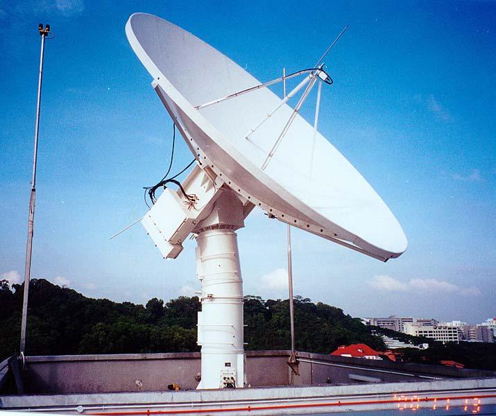
2 6 metre Antenna 13 metre Antenna 1.5 metre Antenna

3 Data Processing Facilities

4 CRISP Ground Station Coverage
5 CRISP Ground Station Satellite Data CRISP received since 1995: 1. SPOT 1,2,4 (France, Sep 1995) 1,110,000 scenes 2. ERS 1,2 (Europe, Mar 1996) 26,500 scenes 3. RADARSAT 1 (Canada, Apr 1997 till 1999) 12,000 scenes 4. SeaWiFS (USA, Sep 1999) 5. TERRA MODIS (USA, March 2001) 6. IKONOS (USA, August 2001) 7. EROS (Israel, October 2001) suspended due to ground equipment failure 8. AQUA MODIS (USA, July 2002) 9. SPOT 5 (October 2002) 360,000 scenes
6 Forest Fire Monitoring


7 Regional fire monitoring operation SPOT data reception Planning SPOT passes aided by MODIS or AVHRR hot spot maps Detection of fire and smoke plumes Annoted fire image and fire report

8 Planning of SPOT Pass


9 MODIS Hotspot SPOT 2 Image
10 Fires in 2006 The yearly vegetation fires in Sumatra and Kalimantan were made worse in 2006 by the onset of a mild El-Nino event. This brought drier weather at the tail end of the fire season (September and October) to South Sumatra and Kalimantan. The fires in South Sumatra and Kalimantan in this period were the most severe in recent years. The PSI in Singapore (on Oct 7) also hit the highest level since 1997.

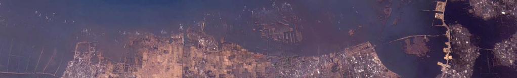
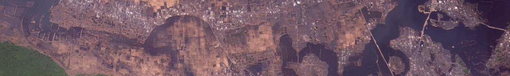
11 High resolution satellite imagery: South Sumatra

12 SPOT4 Image, Sep 28, 2006

13 Red regions recent burning activities (ground still very hot)

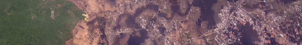
14 IKONOS Image, September 29, 2006

15 Systems of Canals, indicating intention of converting to plantations

16 Some Observations of the spatial and temporal patterns of fires detected by high resolution SPOT images

17 Comparison of hotspots in September Hotspots, 2nd half of September 2005 Hotspots, 2nd half of September 2006
18 Comparison of hotspots in October Hotspots, 1st half of October 2005 Hotspots, 1st half of October 2006
19 Monthly Fire Count &. Monthly Rainfall (Sumatra) Average Monthly Fire Count (Sumatra, ) Climatological Mean Monthly Rainfall (Pekan Baru) Jan Feb Mar Apr May Jun Jul Aug Sep Oct Nov Dec 0
20 Monthly Fire Count (Sumatra) 2006 vs mean 140 Monthly Fire Count (Sumatra) Mean 2006 Jan Feb Mar Apr May Jun Jul Aug Sep Oct Nov Dec
21 Validation of MODIS Hotspots Using High Resolution SPOT Images SC Liew et al (2003), Proc. 24th Asian Conference on Remote Sensing & 2003 International Symposium on Remote Sensing Vol. I, pp
22 Validation of MODIS Hotspots Use high resolution SPOT multispectral images as the reference data The reference SPOT data are acquired almost simultaneously as the MODIS data Detection of fires in SPOT images» Use visible smoke plumes to locate fires» The locations of the active fires are determined from the points of origin of the individual smoke plumes.» Intense fires with efficient combustion may not produce sufficient smoke plumes and would not be detected. Such fires are not very common in the humid tropics, due to the high humidity. Detection of MODIS hotspots» Use standard NASA v4 algorithm

23 An example: 19 Aug 2002 Central Kalimantan SPOT acquisition: 02:58 UTC MODIS acquisition 03:15 UTC Yellow dots are locations of fires detected in SPOT Green dots are locations of MODIS hotspots
24 Results MODIS Hotspots Validated by SPOT SPOT Fires 180 Detected by MODIS 181 False Alarms 66 Not Detected 94 Total 246 Total 275 Commission Error Rate 26.8% Omission Error Rate 34.2%
25 Comparison with a study conducted in Southern Africa MODIS Hotspots ASTER fires Validated by ASTER 33 Detected by MODIS False alarms 3 Undetected fires Total 36 Total 131 Commission Error Rate 0.8% Omission Error Rate 74.8% Source: C. O. Justice, L. Giglio, S. Korontzi, J. Owens, J. T. Morisette, D. Roy, J. Descloitres, S. Alleaume, F. Petitcolin, and Y. Kaufman, The MODIS fire products. Remote Sensing of Environment, 83:
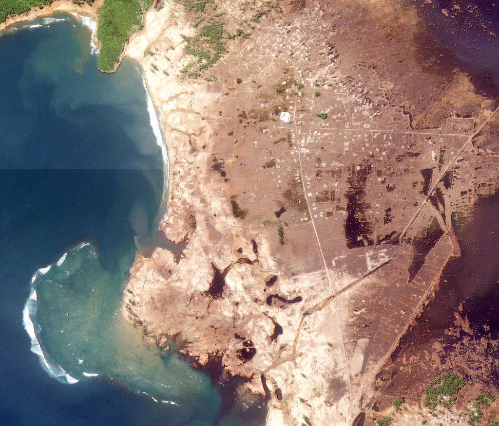
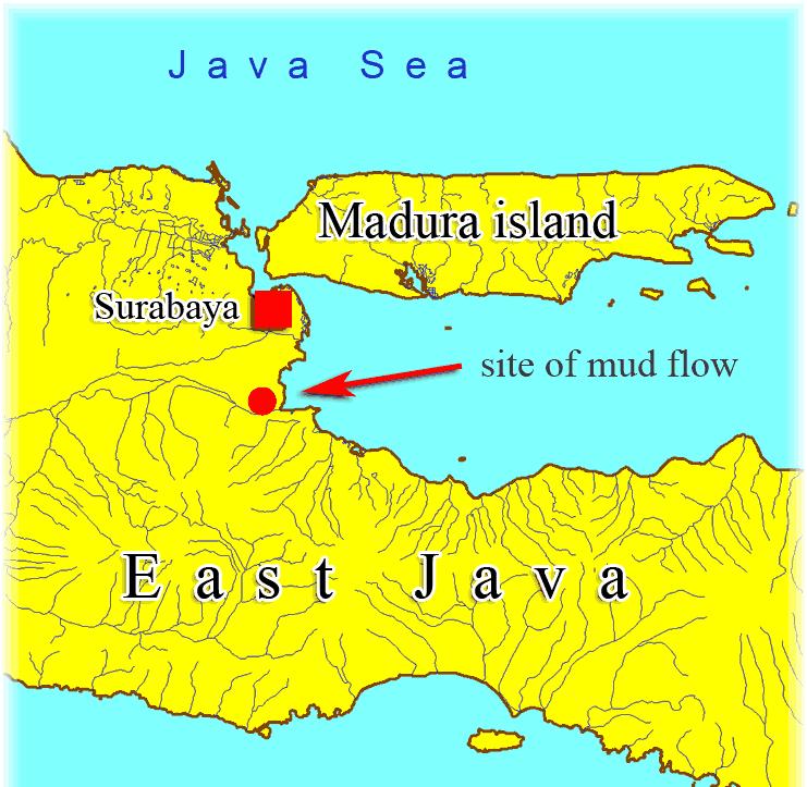
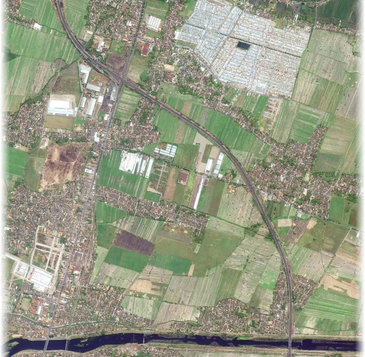
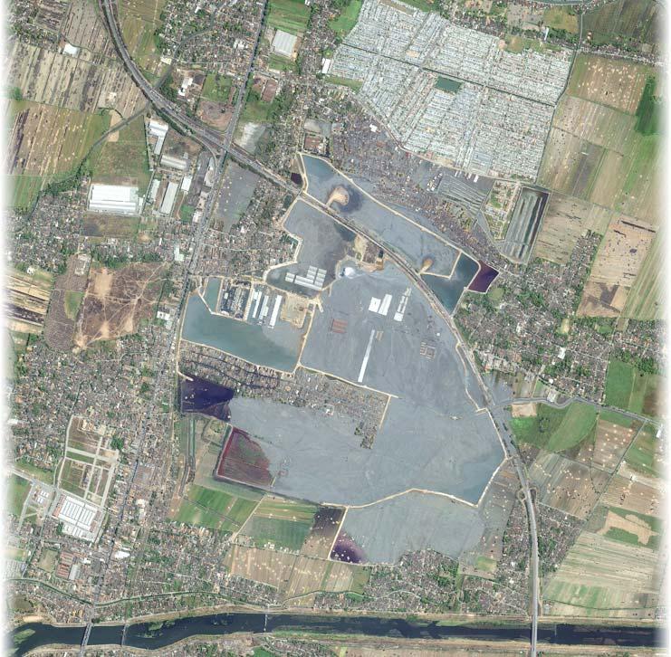
26 South Asia Tsunami
, 07:58 am")

27 26 December 2004, 00:58 am (UTC), 07:58 am (local time) Subduction of India plate under Sunda plate


28 Banda Aceh 10 Jan Dec km x 22 km


29 Banda Aceh

30 Banda Aceh
31 Lhoknga
32 Lhoknga
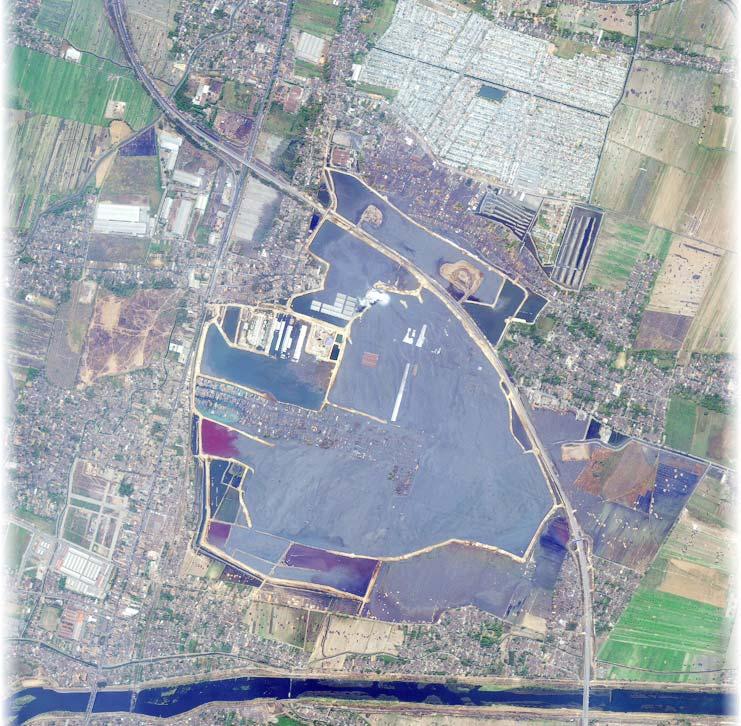
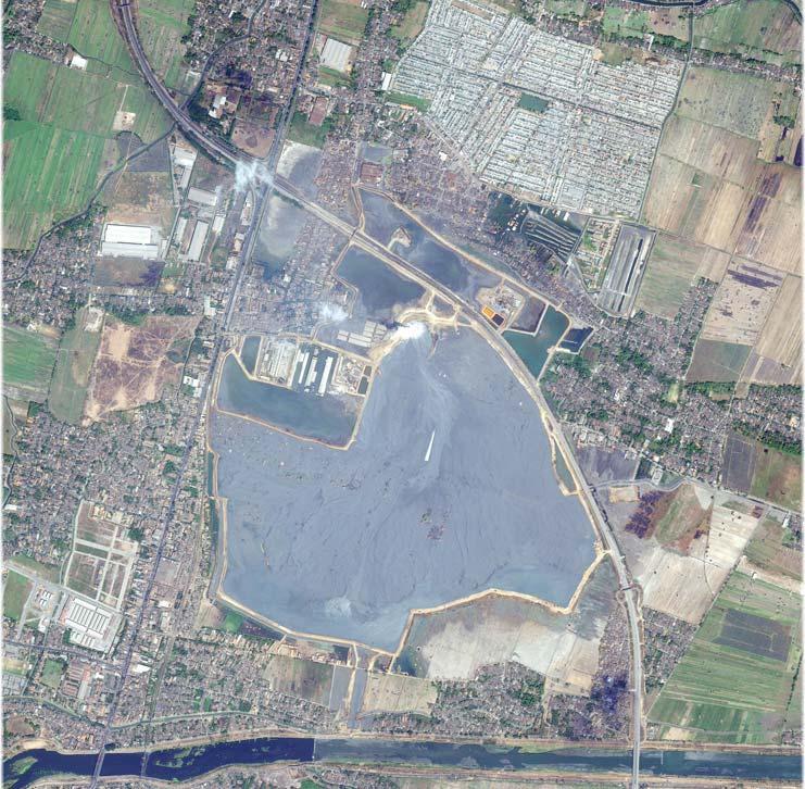
33 Java Mudflow (August 2006)
34
35
36
37
38
39 Other Natural Disasters

40 09 May May 2006
41

42 before Tsunami after Tsunami

43 Village of Guinsaugon on 2 Sept 2004

44 Village of Guinsaugon on 1 Mar 2006

45 IKONOS Image of PADANG (8 Mar 07)

46 IKONOS Image of SOLOK (8 Mar 07)

47 IKONOS Image of Bukit Tinggi (16 May 02)

48 IKONOS Image of Bukit Tinggi (08 Mar 07) (Showing Landslides possibly results of Earthquake)
49 Sentinel Asia (Fire Hotspots)
50 Implementation Progress CRISP Hotspot server to host our hotspots is ready; updated after every MODIS pass. CRISP server implemented with opensource Mapserver software originally developed by the University of Minnosota in 1994 ( URL to access CRISP Webgis:

51 TERRA MODIS 12 Jan 07

52 TERRA MODIS 12 Jan 07

53 AQUA MODIS 12 Jan 07
54 AQUA MODIS 12 Jan 07
55
SPATIAL AND TEMPORAL PATTERN OF FOREST/PLANTATION FIRES IN RIAU, SUMATRA FROM 1998 TO 2000
 SPATIAL AND TEMPORAL PATTERN OF FOREST/PLANTATION FIRES IN RIAU, SUMATRA FROM 1998 TO 2000 SHEN Chaomin, LIEW Soo Chin, KWOH Leong Keong Centre for Remote Imaging, Sensing and Processing (CRISP) Faculty
USAGE AND PLANS OF HOTSPOT INFORMATION IN INDONESIA
 USAGE AND PLANS OF HOTSPOT INFORMATION IN INDONESIA Orbita Roswintiarti Natural Resources and Environmental Monitoring Division Indonesian National Institute of Aeronautics and Space (LAPAN) http://www.rs
GAMINGRE 8/1/ of 7
 FYE 09/30/92 JULY 92 0.00 254,550.00 0.00 0 0 0 0 0 0 0 0 0 254,550.00 0.00 0.00 0.00 0.00 254,550.00 AUG 10,616,710.31 5,299.95 845,656.83 84,565.68 61,084.86 23,480.82 339,734.73 135,893.89 67,946.95
Interannual variation of MODIS NDVI in Lake Taihu and its relation to climate in submerged macrophyte region
 Yale-NUIST Center on Atmospheric Environment Interannual variation of MODIS NDVI in Lake Taihu and its relation to climate in submerged macrophyte region ZhangZhen 2015.07.10 1 Outline Introduction Data
KARI Activation for the International Disasters
 KARI Activation for the International Disasters 5 th Joint Project Team Meeting for Sentinel Asia STEP2 (JPTM2012) 14 th Nov 2012 Boyeol Yoon Senior Researcher, Satellite Information Research Center (SIRC)
El Nino 2015 in South Sudan: Impacts and Perspectives. Raul Cumba
 El Nino 2015 in South Sudan: Impacts and Perspectives Raul Cumba El Nino 2015-2016 The El Nino Event of 2015-2016 The 2015/16 El Nino Event Officially declared in March 2015 Now approaching peak intensity
COUNTRY REPORT. Jakarta. July, th National Directorate of Meteorology and Geophysics of Timor-Leste (DNMG)
") The Southeastern Asia-Oceania Flash Flood COUNTRY REPORT Jakarta. July, 10-12 th 2017 National Directorate of Meteorology and Geophysics of Timor-Leste (DNMG) Carla Feritas and Crisostimo Lobato Democratic
The Southeastern Asia-Oceania Flash Flood COUNTRY REPORT Jakarta. July, 10-12 th 2017 National Directorate of Meteorology and Geophysics of Timor-Leste (DNMG) Carla Feritas and Crisostimo Lobato Democratic
OVERVIEW OF IMPROVED USE OF RS INDICATORS AT INAM. Domingos Mosquito Patricio
 OVERVIEW OF IMPROVED USE OF RS INDICATORS AT INAM Domingos Mosquito Patricio domingos.mosquito@gmail.com Introduction to Mozambique /INAM Introduction to AGRICAB/SPIRITS Objectives Material & Methods Results
BMKG Research on Air sea interaction modeling for YMC
 BMKG Research on Air sea interaction modeling for YMC Prof. Edvin Aldrian Director for Research and Development - BMKG First Scientific and Planning Workshop on Year of Maritime Continent, Singapore 27-3
Weather Satellite Data Applications for Monitoring and Warning Hazard at BMKG
 The 5th Meeting of the Coordinating Group of the RA II WIGOS Satellite Project 21 October 2017, Vladivostok city, Russky Island, Russia Far Eastern Federal University Weather Satellite Data Applications
UPDATE OF REGIONAL WEATHER AND SMOKE HAZE April 2016
 UPDATE OF REGIONAL WEATHER AND SMOKE HAZE April 2016 1. Review of Regional Weather Conditions in March 2016 1.1 Weak Northeast Monsoon conditions prevailed in March 2016 with winds that were. Light and
GI Technology for Disaster Management
 GI Technology for Disaster Management 17 th ICC on the Regional Space Applications Programme for Sustainable Development (RESAP) 26 th Nov 2013 Bangkok Thailand Period and time of seasonal in thailand
PROJECT REPORT (ASL 720) CLOUD CLASSIFICATION
 CLOUD CLASSIFICATION") PROJECT REPORT (ASL 720) CLOUD CLASSIFICATION SUBMITTED BY- PRIYANKA GUPTA 2011CH70177 RINI KAPOOR 2011CH70179 INDIVIDUAL CONTRIBUTION- Priyanka Gupta- analysed data of region considered in India (West:80,
PROJECT REPORT (ASL 720) CLOUD CLASSIFICATION SUBMITTED BY- PRIYANKA GUPTA 2011CH70177 RINI KAPOOR 2011CH70179 INDIVIDUAL CONTRIBUTION- Priyanka Gupta- analysed data of region considered in India (West:80,
UPDATE OF REGIONAL WEATHER AND SMOKE HAZE February 2016
 UPDATE OF REGIONAL WEATHER AND SMOKE HAZE February 2016 1. Review of Regional Weather Conditions in January 2016 1.1 The Northeast Monsoon conditions prevailed in the region in January 2016. With the monsoon
WHEN IS IT EVER GOING TO RAIN? Table of Average Annual Rainfall and Rainfall For Selected Arizona Cities
 WHEN IS IT EVER GOING TO RAIN? Table of Average Annual Rainfall and 2001-2002 Rainfall For Selected Arizona Cities Phoenix Tucson Flagstaff Avg. 2001-2002 Avg. 2001-2002 Avg. 2001-2002 October 0.7 0.0
UPDATE OF REGIONAL WEATHER AND SMOKE HAZE (February 2018)
") UPDATE OF REGIONAL WEATHER AND SMOKE HAZE (February 2018) 1. Review of Regional Weather Conditions for January 2018 1.1 The prevailing Northeast monsoon conditions over Southeast Asia strengthened in January
UPDATE OF REGIONAL WEATHER AND SMOKE HAZE (February 2018) 1. Review of Regional Weather Conditions for January 2018 1.1 The prevailing Northeast monsoon conditions over Southeast Asia strengthened in January
Global Climates. Name Date
 Global Climates Name Date No investigation of the atmosphere is complete without examining the global distribution of the major atmospheric elements and the impact that humans have on weather and climate.
DROUGHT IN MAINLAND PORTUGAL
 DROUGHT IN MAINLAND Ministério da Ciência, Tecnologia e Ensino Superior Instituto de Meteorologia, I. P. Rua C Aeroporto de Lisboa Tel.: (351) 21 844 7000 e-mail:informacoes@meteo.pt 1749-077 Lisboa Portugal
10 emergency observation requests were successfully processed during the period
 ISRO s Inputs for the Sentinel Asia DPN and JPT meeting being held during 13-16, 16, November 2012 November 2012 Sentinel Asia Activity Spectrum - A dedicated Sentinel Asia server established at NRSC,
UPDATE OF REGIONAL WEATHER AND SMOKE HAZE November 2016
 UPDATE OF REGIONAL WEATHER AND SMOKE HAZE November 2016 1. Review of Regional Weather Conditions in November 2016 1.1 Southwest Monsoon conditions prevailed on most days in October 2016 and the winds were
Long-lead prediction of the 2015 fire and haze episode in Indonesia
 Long-lead prediction of the 2015 fire and haze episode in Indonesia Robert Field 1,2 Dilshad Shawki 3, Michael Tippett 2, Bambang Hero Saharjo 4, Israr Albar 5, Dwi Atmoko 6, Apostolos Voulgarakis 1 1.
Jackson County 2013 Weather Data
 Jackson County 2013 Weather Data 61 Years of Weather Data Recorded at the UF/IFAS Marianna North Florida Research and Education Center Doug Mayo Jackson County Extension Director 1952-2008 Rainfall Data
P7.7 A CLIMATOLOGICAL STUDY OF CLOUD TO GROUND LIGHTNING STRIKES IN THE VICINITY OF KENNEDY SPACE CENTER, FLORIDA
 P7.7 A CLIMATOLOGICAL STUDY OF CLOUD TO GROUND LIGHTNING STRIKES IN THE VICINITY OF KENNEDY SPACE CENTER, FLORIDA K. Lee Burns* Raytheon, Huntsville, Alabama Ryan K. Decker NASA, Marshall Space Flight
UPDATE OF REGIONAL WEATHER AND SMOKE HAZE FOR MAY 2015
 UPDATE OF REGIONAL WEATHER AND SMOKE HAZE FOR MAY 2015 1. Review of Regional Weather Conditions in April 2015 1.1 Inter-Monsoon conditions prevailed over the ASEAN region in April 2015. The gradual northward
PYROGEOGRAPHY OF THE IBERIAN PENINSULA
 PYROGEOGRAPHY OF THE IBERIAN PENINSULA Teresa J. Calado (1), Carlos C. DaCamara (1), Sílvia A. Nunes (1), Sofia L. Ermida (1) and Isabel F. Trigo (1,2) (1) Instituto Dom Luiz, Universidade de Lisboa, Lisboa,
UPDATE OF REGIONAL WEATHER AND SMOKE HAZE December 2016
 UPDATE OF REGIONAL WEATHER AND SMOKE HAZE December 2016 1. Review of Regional Weather Conditions in November 2016 1.1 Inter monsoon conditions prevailed in the first half of November 2016. During this
Sierra Weather and Climate Update
 Sierra Weather and Climate Update 2014-15 Kelly Redmond Western Regional Climate Center Desert Research Institute Reno Nevada Yosemite Hydroclimate Workshop Yosemite Valley, 2015 October 8-9 Percent of
UPDATE OF REGIONAL WEATHER AND SMOKE HAZE (December 2017)
") UPDATE OF REGIONAL WEATHER AND SMOKE HAZE (December 2017) 1. Review of Regional Weather Conditions for November 2017 1.1 In November 2017, Southeast Asia experienced inter-monsoon conditions in the first
UPDATE OF REGIONAL WEATHER AND SMOKE HAZE (December 2017) 1. Review of Regional Weather Conditions for November 2017 1.1 In November 2017, Southeast Asia experienced inter-monsoon conditions in the first
Orbit Design Marcelo Suárez. 6th Science Meeting; Seattle, WA, USA July 2010
 Orbit Design Marcelo Suárez Orbit Design Requirements The following Science Requirements provided drivers for Orbit Design: Global Coverage: the entire extent (100%) of the ice-free ocean surface to at
YACT (Yet Another Climate Tool)? The SPI Explorer
? The SPI Explorer") YACT (Yet Another Climate Tool)? The SPI Explorer Mike Crimmins Assoc. Professor/Extension Specialist Dept. of Soil, Water, & Environmental Science The University of Arizona Yes, another climate tool for
YACT (Yet Another Climate Tool)? The SPI Explorer Mike Crimmins Assoc. Professor/Extension Specialist Dept. of Soil, Water, & Environmental Science The University of Arizona Yes, another climate tool for
Recent peat fire trend in the Mega Rice Project (MRP) area in Central Kalimantan, Indonesia
 area in Central Kalimantan, Indonesia") Recent peat fire trend in the Mega Rice Project (MRP) area in Central Kalimantan, Indonesia Erianto Indra Putra Candidate for the Degree of Doctor of Philosophy Supervisor : Associate Prof. Hiroshi Hayasaka
Recent peat fire trend in the Mega Rice Project (MRP) area in Central Kalimantan, Indonesia Erianto Indra Putra Candidate for the Degree of Doctor of Philosophy Supervisor : Associate Prof. Hiroshi Hayasaka
Temporal Trends in Forest Fire Season Length
 Temporal Trends in Forest Fire Season Length Alisha Albert-Green aalbertg@sfu.ca Department of Statistics and Actuarial Science Simon Fraser University Stochastic Modelling of Forest Dynamics Webinar March
2003 Water Year Wrap-Up and Look Ahead
 2003 Water Year Wrap-Up and Look Ahead Nolan Doesken Colorado Climate Center Prepared by Odie Bliss http://ccc.atmos.colostate.edu Colorado Average Annual Precipitation Map South Platte Average Precipitation
JOINT BRIEFING TO THE MEMBERS. El Niño 2018/19 Likelihood and potential impact
 JOINT BRIEFING TO THE MEMBERS El Niño 2018/19 Likelihood and potential impact CURRENT EL NIÑO OUTLOOK (SEPTEMBER 2018) CPC/IRI ENSO Forecast from September. Red bars denote probability of an El Nino developing
DROUGHT INDICES BEING USED FOR THE GREATER HORN OF AFRICA (GHA)
") DROUGHT INDICES BEING USED FOR THE GREATER HORN OF AFRICA (GHA) Christopher Oludhe IGAD Climate Prediction and Applications Centre (ICPAC) Inter-Regional Workshop on Indices and Early Warning Systems for
DROUGHT INDICES BEING USED FOR THE GREATER HORN OF AFRICA (GHA) Christopher Oludhe IGAD Climate Prediction and Applications Centre (ICPAC) Inter-Regional Workshop on Indices and Early Warning Systems for
Verification of the Seasonal Forecast for the 2005/06 Winter
 Verification of the Seasonal Forecast for the 2005/06 Winter Shingo Yamada Tokyo Climate Center Japan Meteorological Agency 2006/11/02 7 th Joint Meeting on EAWM Contents 1. Verification of the Seasonal
Variability and trends in daily minimum and maximum temperatures and in diurnal temperature range in Lithuania, Latvia and Estonia
 Variability and trends in daily minimum and maximum temperatures and in diurnal temperature range in Lithuania, Latvia and Estonia Jaak Jaagus Dept. of Geography, University of Tartu Agrita Briede Dept.
Dust storm variability over EGYPT By Fathy M ELashmawy Egyptian Meteorological Authority
 WMO WORKSHOP ON CLIMATE MONITORING INCLUDING THE IMPLEMENTATION OF CLIMATE WATCH SYSTEMS FOR ARAB COUNTRIES IN WEST ASIA, AMMAN, JORDAN, 27-29 MAY 2013 Dust storm variability over EGYPT By Fathy M ELashmawy
"STUDY ON THE VARIABILITY OF SOUTHWEST MONSOON RAINFALL AND TROPICAL CYCLONES FOR "
 "STUDY ON THE VARIABILITY OF SOUTHWEST MONSOON RAINFALL AND TROPICAL CYCLONES FOR 2001 2010" ESPERANZA O. CAYANAN, Ph.D. Chief, Climatology & Agrometeorology R & D Section Philippine Atmospheric Geophysical
El Nino 2015: The Story So Far and What To Expect Next
 El Nino 2015: The Story So Far and What To Expect Next The El Nino Event of 2015-2016 The 2015/16 El Nino Event Officially declared in March 2015 Now approaching peak intensity Expected to last through
El Nino 2015: The Story So Far and What To Expect Next
 El Nino 2015: The Story So Far and What To Expect Next The El Nino Event of 2015-2016 The 2015/16 El Nino Event Officially declared in March 2015 Now approaching peak intensity Expected to last through
Sandra Lohberger, Werner Wiedemann, Florian Siegert
 FIRE_CCI Special Case Study on Fires in Indonesia and El Niño: Object-based burned area detection and related fire emission estimations based on Sentinel-1 data D4 Burned area 216 Prepared for European
Aniekan Eyoh 1* Department of Geoinformatics & Surveying, Faculty of Environmental Studies, University of Uyo, Nigeria
 Available online at http://euroasiapub.org/journals.php, pp. 53~62 Thomson Reuters Researcher ID: L-5236-2015 TEMPORAL APPRAISAL OF LAND SURFACE TEMPERATURE DYNAMICS ACROSS THE NINE STATES OF NIGER DELTA
Drought Characterization. Examination of Extreme Precipitation Events
 Drought Characterization Examination of Extreme Precipitation Events Extreme Precipitation Events During the Drought For the drought years (1999-2005) daily precipitation data was analyzed to find extreme
Long-term Water Quality Monitoring in Estero Bay
 Long-term Water Quality Monitoring in Estero Bay Keith Kibbey Laboratory Director Lee County Environmental Laboratory Division of Natural Resource Management Estero Bay Monitoring Programs Three significant
Agricultural Science Climatology Semester 2, Anne Green / Richard Thompson
 Agricultural Science Climatology Semester 2, 2006 Anne Green / Richard Thompson http://www.physics.usyd.edu.au/ag/agschome.htm Course Coordinator: Mike Wheatland Course Goals Evaluate & interpret information,
LECTURE ONE The Astronomy of Climate
 LECTURE ONE The Astronomy of Climate Agricultural Science Climatology Semester 2, 2006 Richard Thompson http://www.physics.usyd.edu.au/ag/agschome.htm Course Coordinator: Mike Wheatland AMMENDED TIMETABLE
Changing Hydrology under a Changing Climate for a Coastal Plain Watershed
 Changing Hydrology under a Changing Climate for a Coastal Plain Watershed David Bosch USDA-ARS, Tifton, GA Jeff Arnold ARS Temple, TX and Peter Allen Baylor University, TX SEWRU Objectives 1. Project changes
Memo. I. Executive Summary. II. ALERT Data Source. III. General System-Wide Reporting Summary. Date: January 26, 2009 To: From: Subject:
 Memo Date: January 26, 2009 To: From: Subject: Kevin Stewart Markus Ritsch 2010 Annual Legacy ALERT Data Analysis Summary Report I. Executive Summary The Urban Drainage and Flood Control District (District)
Analysis of Historical Pattern of Rainfall in the Western Region of Bangladesh
 24 25 April 214, Asian University for Women, Bangladesh Analysis of Historical Pattern of Rainfall in the Western Region of Bangladesh Md. Tanvir Alam 1*, Tanni Sarker 2 1,2 Department of Civil Engineering,
Sentinel Asia System Operation for Disaster Management in Sri Lanka Major General L.B.R. Mark (Retd) Director General Disaster Management Centre
 Director General Disaster Management Centre") Sentinel Asia System Operation for Disaster Management in Sri Lanka Major General L.B.R. Mark (Retd) Director General Disaster Management Centre Government of Sri Lanka OUTLINE Background Disasters in
Sentinel Asia System Operation for Disaster Management in Sri Lanka Major General L.B.R. Mark (Retd) Director General Disaster Management Centre Government of Sri Lanka OUTLINE Background Disasters in
A SUMMARY OF RAINFALL AT THE CARNARVON EXPERIMENT STATION,
 A SUMMARY OF RAINFALL AT THE CARNARVON EXPERIMENT STATION, 1931-213 J.C.O. Du Toit 1#, L. van den Berg 1 & T.G. O Connor 2 1 Grootfontein Agricultural Development Institute, Private Bag X529, Middelburg
March was 3rd warmest month in satellite record
 April 4, 2016 Vol. 25, No. 12 For Additional Information: Dr. John Christy, (256) 961-7763 john.christy@nsstc.uah.edu Dr. Roy Spencer, (256) 961-7960 roy.spencer@nsstc.uah.edu Global Temperature Report:
Jackson County 2018 Weather Data 67 Years of Weather Data Recorded at the UF/IFAS Marianna North Florida Research and Education Center
 Jackson County 2018 Weather Data 67 Years of Weather Data Recorded at the UF/IFAS Marianna North Florida Research and Education Center Doug Mayo Jackson County Extension Director 1952-2008 Rainfall Data
GEOG Lecture 8. Orbits, scale and trade-offs
 Environmental Remote Sensing GEOG 2021 Lecture 8 Orbits, scale and trade-offs Orbits revisit Orbits geostationary (36 000 km altitude) polar orbiting (200-1000 km altitude) Orbits revisit Orbits geostationary
Convective-scale NWP for Singapore
 Convective-scale NWP for Singapore Hans Huang and the weather modelling and prediction section MSS, Singapore Dale Barker and the SINGV team Met Office, Exeter, UK ECMWF Symposium on Dynamical Meteorology
Government of Sultanate of Oman Public Authority of Civil Aviation Directorate General of Meteorology. National Report To
 Government of Sultanate of Oman Public Authority of Civil Aviation Directorate General of Meteorology National Report To Panel on Tropical Cyclones in the Bay of Bengal And Arabian Sea 43rd Session, India
Aerosol Retrieved from MODIS: Algorithm, Products, Validation and the Future
 Aerosol Retrieved from MODIS: Algorithm, Products, Validation and the Future Presented by: Rob Levy Re-presenting NASA-GSFC s MODIS aerosol team: Y. Kaufman, L. Remer, A. Chu,, C. Ichoku,, R. Kleidman,,
Many of remote sensing techniques are generic in nature and may be applied to a variety of vegetated landscapes, including
 Remote Sensing of Vegetation Many of remote sensing techniques are generic in nature and may be applied to a variety of vegetated landscapes, including 1. Agriculture 2. Forest 3. Rangeland 4. Wetland,
Average temperature ( F) World Climate Zones. very cold all year with permanent ice and snow. very cold winters, cold summers, and little rain or snow
 World Climate Zones. very cold all year with permanent ice and snow. very cold winters, cold summers, and little rain or snow") P r e v i e w Look carefully at the climagraph of Mumbai, India. What is the wettest month (or months) in Mumbai? What is the driest month (or months) in Mumbai? What effects might this city s climate
P r e v i e w Look carefully at the climagraph of Mumbai, India. What is the wettest month (or months) in Mumbai? What is the driest month (or months) in Mumbai? What effects might this city s climate
Chiang Rai Province CC Threat overview AAS1109 Mekong ARCC
 Chiang Rai Province CC Threat overview AAS1109 Mekong ARCC This threat overview relies on projections of future climate change in the Mekong Basin for the period 2045-2069 compared to a baseline of 1980-2005.
Infrastructure : Technology required to develop, access and utilize information and data (softwares and hardwares)
") Mastura Mahmud School of Social, Development and Environment Faculty of Social Sciences and Humanities Universiti Kebangsaan Malaysia 1 Capacity Building : through cohesive methodology to produce skilled
Mastura Mahmud School of Social, Development and Environment Faculty of Social Sciences and Humanities Universiti Kebangsaan Malaysia 1 Capacity Building : through cohesive methodology to produce skilled
WEATHER AND CLIMATE EXTREMES MONITORING BASED ON SATELLITE OBSERVATION : INDONESIA PERSPECTIVE RIRIS ADRIYANTO
 WEATHER AND CLIMATE EXTREMES MONITORING BASED ON SATELLITE OBSERVATION : INDONESIA PERSPECTIVE RIRIS ADRIYANTO INDONESIA AGENCY FOR METEOROLOGY, CLIMATOLOGY AND GEOPHYSICS (BM KG) 1. INTRODUCTION - BMKG
Combining sensor and forecast information to aid decision making: real-time determination of hydrological peat fire risk in Kalimantan
 Combining sensor and forecast information to aid decision making: real-time determination of hydrological peat fire risk in Kalimantan Jaap Schellekens Based on work by: Aljosja Hooijer, Ronald Vernimmen,
UWM Field Station meteorological data
 University of Wisconsin Milwaukee UWM Digital Commons Field Station Bulletins UWM Field Station Spring 992 UWM Field Station meteorological data James W. Popp University of Wisconsin - Milwaukee Follow
Comparison of NASA AIRS and MODIS Land Surface Temperature and Infrared Emissivity Measurements from the EOS AQUA platform
 Comparison of NASA AIRS and MODIS Land Surface Temperature and Infrared Emissivity Measurements from the EOS AQUA platform Robert Knuteson, Steve Ackerman, Hank Revercomb, Dave Tobin University of Wisconsin-Madison
Atmospheric circulation analysis for seasonal forecasting
 Training Seminar on Application of Seasonal Forecast GPV Data to Seasonal Forecast Products 18 21 January 2011 Tokyo, Japan Atmospheric circulation analysis for seasonal forecasting Shotaro Tanaka Climate
July 2017 LOGISTICAL HARMONY
 Li s&staging(wpedestriansidewalkprot.) (4/18/through7/18/2017) July2017 101BelvidereEastFaçadeWorkPipeStaging (4/18/through7/18/2017) 101BelvidereEastFaçadeWork (through8/31/2017) Legend RampaccesstoTMCX
Long Range Forecasts of 2015 SW and NE Monsoons and its Verification D. S. Pai Climate Division, IMD, Pune
 Long Range Forecasts of 2015 SW and NE Monsoons and its Verification D. S. Pai Climate Division, IMD, Pune Other Contributors: Soma Sen Roy, O. P. Sreejith, Kailas, Madhuri, Pallavi, Mahendra and Jasmine
El Nino: Outlook VAM-WFP HQ September 2018
 El Nino: Outlook 2018 VAM-WFP HQ September 2018 El Nino Outlook September 2018 2015-16 El Nino Peak Possible evolution of an El Nino indicator (Pacific sea surface temperature anomaly) generated by a diverse
July, International SWAT Conference & Workshops
 July, 212 212 International SWAT Conference & Workshops Hydrological Modelling of Kosi and Gandak Basins using SWAT Model S. Dutta, Pritam Biswas, Sangita Devi, Suresh A Karth and Bimlesh kumar, Ganga
Regional Air Quality Monitoring and Forecasting using Remote Sensing Satellites, Ground-level Measurements and Numerical Modelling
 Regional Air Quality Monitoring and Forecasting using Remote Sensing Satellites, Ground-level Measurements and Numerical Modelling PI: Santo V. Salinas [a] Collaborators: Ellsworth J. Welton [b], Brent
Drought in Southeast Colorado
 Drought in Southeast Colorado Nolan Doesken and Roger Pielke, Sr. Colorado Climate Center Prepared by Tara Green and Odie Bliss http://climate.atmos.colostate.edu 1 Historical Perspective on Drought Tourism
Winter Season Resource Adequacy Analysis Status Report
 Winter Season Resource Adequacy Analysis Status Report Tom Falin Director Resource Adequacy Planning Markets & Reliability Committee October 26, 2017 Winter Risk Winter Season Resource Adequacy and Capacity
CHAPTER-11 CLIMATE AND RAINFALL
 CHAPTER-11 CLIMATE AND RAINFALL 2.1 Climate Climate in a narrow sense is usually defined as the "average weather", or more rigorously, as the statistical description in terms of the mean and variability
El Nino: Outlook 2018
 El Nino: Outlook 2018 VAM-WFP HQ December 2018 WFP VAM Food Security Analysis El Nino Outlook December 2018 2015-16 El Nino Peak Possible evolution of an El Nino indicator (Pacific sea surface temperature
ENGINE SERIAL NUMBERS
 ENGINE SERIAL NUMBERS The engine number was also the serial number of the car. Engines were numbered when they were completed, and for the most part went into a chassis within a day or so. However, some
Satellite-derived environmental drivers for top predator hotspots
 Satellite-derived environmental drivers for top predator hotspots Peter Miller @PeterM654 South West Marine Ecosystems 2017 21 Apr. 2017, Plymouth University Satellite environmental drivers for hotspots
UPDATE OF REGIONAL WEATHER AND SMOKE HAZE (May 2017)
") UPDATE OF REGIONAL WEATHER AND SMOKE HAZE (May 2017) 1. Review of Regional Weather Conditions in April 2017 1.1 Inter monsoon conditions, characterised by afternoon showers and winds that are generally
UPDATE OF REGIONAL WEATHER AND SMOKE HAZE (May 2017) 1. Review of Regional Weather Conditions in April 2017 1.1 Inter monsoon conditions, characterised by afternoon showers and winds that are generally
Using Reanalysis SST Data for Establishing Extreme Drought and Rainfall Predicting Schemes in the Southern Central Vietnam
 Using Reanalysis SST Data for Establishing Extreme Drought and Rainfall Predicting Schemes in the Southern Central Vietnam Dr. Nguyen Duc Hau 1, Dr. Nguyen Thi Minh Phuong 2 National Center For Hydrometeorological
GTR # VLTs GTR/VLT/Day %Δ:
 MARYLAND CASINOS: MONTHLY REVENUES TOTAL REVENUE, GROSS TERMINAL REVENUE, WIN/UNIT/DAY, TABLE DATA, AND MARKET SHARE CENTER FOR GAMING RESEARCH, DECEMBER 2017 Executive Summary Since its 2010 casino debut,
Current and Future Impacts of Wildfires on PM 2.5, Health, and Policy in the Rocky Mountains
 Current and Future Impacts of Wildfires on PM 2.5, Health, and Policy in the Rocky Mountains Yang Liu, Ph.D. STAR Grants Kick-off Meeting Research Triangle Park, NC April 5, 2017 Motivation The Rocky Mountains
Satellite data for African applications
 Satellite data for African applications Henk Verschuur, EUMETSAT henk.verschuur@eumetsat.int Introduction Some examples of satellite products which are useful for Africa Satellite products Tropical cyclones
Imaging the whole Earth every day. Josh Alban VP, Business Development
 Imaging the whole Earth every day Josh Alban VP, Business Development josh@planet.com Planet Labs helps you detect and act on change by imaging the whole Earth everyday. Challenges Limited Coverage Low
8 VISIBILITY. 8.1 Setting. 8.2 Assessment Focus. Table 8-1: Key Issue for Visibility
 Volume 2: Environmental and Sturgeon Upgrader Project 8 VISIBILITY 8.1 Setting The Project is in Sturgeon County within Alberta s Industrial Heartland area (the Heartland). The Heartland includes a number
A Report on a Statistical Model to Forecast Seasonal Inflows to Cowichan Lake
 A Report on a Statistical Model to Forecast Seasonal Inflows to Cowichan Lake Prepared by: Allan Chapman, MSc, PGeo Hydrologist, Chapman Geoscience Ltd., and Former Head, BC River Forecast Centre Victoria
Assessment of the Impact of El Niño-Southern Oscillation (ENSO) Events on Rainfall Amount in South-Western Nigeria
 Events on Rainfall Amount in South-Western Nigeria") 2016 Pearl Research Journals Journal of Physical Science and Environmental Studies Vol. 2 (2), pp. 23-29, August, 2016 ISSN 2467-8775 Full Length Research Paper http://pearlresearchjournals.org/journals/jpses/index.html
2016 Pearl Research Journals Journal of Physical Science and Environmental Studies Vol. 2 (2), pp. 23-29, August, 2016 ISSN 2467-8775 Full Length Research Paper http://pearlresearchjournals.org/journals/jpses/index.html
Food Security Monitoring Bulletin. INDONESIA Special Focus: Estimating Impact of Disasters on Market Access
 Food Security Monitoring Bulletin INDONESIA Special Focus: Estimating Impact of Disasters on Market Access Volume 10, May 2018 CLIMATE AND FOOD SECURITY January - April 2018 More floods and landslides
South Eastern Australian Rainfall in relation to the Mean Meridional Circulation
 South Eastern Australian Rainfall in relation to the Mean Meridional Circulation Bertrand Timbal, Hanh Nguyen, Robert Fawcett, Wasyl Drosdowsky and Chris Lucas CAWCR / Bureau of Meteorology Long-term SEA
Cambridge International Examinations Cambridge International General Certificate of Secondary Education
 Cambridge International Examinations Cambridge International General Certificate of Secondary Education *0678655750* ENVIRONMENTAL MANAGEMENT 0680/22 Paper 2 February/March 2018 1 hour 45 minutes Candidates
Geostatistical Analysis of Rainfall Temperature and Evaporation Data of Owerri for Ten Years
 Atmospheric and Climate Sciences, 2012, 2, 196-205 http://dx.doi.org/10.4236/acs.2012.22020 Published Online April 2012 (http://www.scirp.org/journal/acs) Geostatistical Analysis of Rainfall Temperature
Toward a Fire and Haze Early Warning System for Southeast Asia
 FEATURED ARTICLES 13 Toward a Fire and Haze Early Warning System for Southeast Asia Jin Ho YOO a, Jaepil CHO a, Saji HAMEED b, Robert FIELD c, Kok Foo KWAN d, Israr ALBAR e APN Project Reference: / Received:
Appendix B. A proposition for updating the environmental standards using real Earth Albedo and Earth IR Flux for Spacecraft Thermal Analysis
 19 Appendix B A proposition for updating the environmental standards using real Earth Albedo and Earth IR Romain Peyrou-Lauga (ESA/ESTEC, The Netherlands) 31 st European Space Thermal Analysis Workshop
Physical Features of Monsoon Asia. 192 Unit 7 Teachers Curriculum Institute 60 N 130 E 140 E 150 E 60 E 50 N 160 E 40 N 30 N 150 E.
 50 N 60 E 70 E 80 E 90 E 100 E 60 N 110 E 120 E 130 E 140 E 150 E 50 N 160 E 40 N 40 N 30 N 60 E 30 N 150 E Tropic of Cancer 20 N Tropic of Cancer 20 N 10 N 10 N 0 Equator 0 Equator 10 S 10 S 0 500 1,000
Seasonal Climate Watch November 2017 to March 2018
 Seasonal Climate Watch November 2017 to March 2018 Date issued: Oct 26, 2017 1. Overview The El Niño Southern Oscillation (ENSO) continues to develop towards a La Niña state, and is expected to be in at
5 - Seasons. Figure 1 shows two pictures of the Sun taken six months apart with the same camera, at the same time of the day, from the same location.
 ASTR 110L 5 - Seasons Purpose: To plot the distance of the Earth from the Sun over one year and to use the celestial sphere to understand the cause of the seasons. What do you think? Write answers to questions
(Specification B) 40352H (JUN H01) General Certificate of Secondary Education Higher Tier June 2011 TOTAL. Time allowed 1 hour
 40352H (JUN H01) General Certificate of Secondary Education Higher Tier June 2011 TOTAL. Time allowed 1 hour") Centre Number Surname Candidate Number For Examiner s Use Other Names Candidate Signature Examiner s Initials Geography (Specification B) Unit 2 Hostile World Friday 17 June 2011 For this paper you must
Centre Number Surname Candidate Number For Examiner s Use Other Names Candidate Signature Examiner s Initials Geography (Specification B) Unit 2 Hostile World Friday 17 June 2011 For this paper you must
Country Presentation-Nepal
 Country Presentation-Nepal Mt.Everest, Shiva Pd. Nepal, DHM South Asia Drought Monitor Workshop Dhaka Bangladesh 2 th April 215 Overview Brief Climatology Climate activities- DHM PPCR (Pilot Program for
Implications of Climate Change on Long Lead Forecasting and Global Agriculture. Ray Motha
 Implications of Climate Change on Long Lead Forecasting and Global Agriculture Ray Motha Source: http://www.coaps.fsu.edu/lib/climatoons/toon38.shtml ENSO Teleconnections 30 Observed Monthly Sea Surface
British Colombia Knight Inlet Strait of Georgia Strait of Juan de Fuca
 An Atlas of Oceanic Internal Solitary Waves (February 2004) Knight Inlet Strait of Georgia Strait of Juan de Fuca Overview Knight Inlet, the Strait of Georgia and the Strait of Juan de Fuca are all shallow