Damage Detection of the 2008 Sichuan, China, Earthquake using
|
|
|
- Matilda Elliott
- 5 years ago
- Views:
Transcription
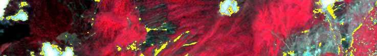
1 Damage Detection of the 2008 Sichuan, China, Earthquake using ALOS/AVNIR-2 Images Wen Liu and Fumio Yamazaki Department of Urban Environment Systems, Chiba University 1
2 Content Overview of China Earthquake ALOS data list Case study River changes extraction Landslide extraction Band threshold Supervised classification SRTM Conclusions Future Work 2


3 Overview of the Sichuan, China Earthquake Magnitude: 7.9 Time: Monday, 2008 May 12 06:28:01 UTC May 12, 2008 at 02:28:01pm.at epicenter Location: N, E Depth: 19km Region: Eastern Sichuan, China Distance: 80 km WNW of Chengdu 145 km WSW of Mianyang 350 km WNW of Chongqing 1545 km SW of Beijing USGS: 中国地震信息网 : Feeling quakes Feeling strong quakes 3


4 ALOS data list Pre-event PSM images m/pixel AV2 images m/pixel PSM images AV2 images 4
5 ALOS data list Post-event PSM images m/pixel AV2 images m/pixel PSM images AV2 images 5
6 ALOS data list The area with little cloud of pre-event and post-event images. PSM AV2 pre-event pee e AV2 post-event 6


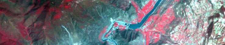


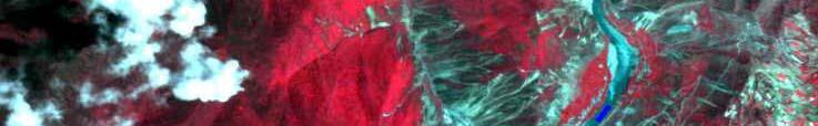
7 Case Study Choosing a target area with both landslide and river changes to study. (after registration by GCPs) Pre-event: March 17 th, 2007 Post-event: May 16 th,
8 River changes Approach of river changes extraction Pre-event images Post-event images Feature study River areas before event River areas after event Noise Removing River changes extraction 8


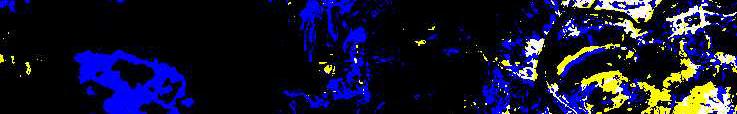
9 Pre-event Pre-event: March 17 th, 2007 Extracting area of river by band threshold. River area: NDVI< ,113 pixels 9


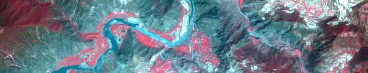
10 Post-event Post-event: May 16 th, 2008 Extracting area of river by band threshold. River area: NDVI< ,348 pixels 10

Closing 3 3")
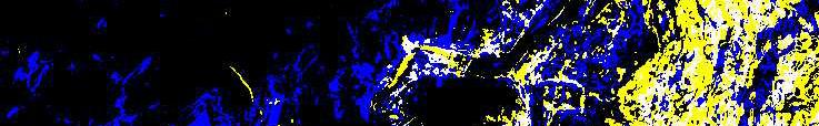
11 Pre-event Pre-event Noises removing Post-event 1)Opening )Closing 3 3 Post-event 11

 36.")
 7.")

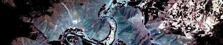
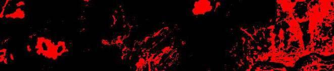
12 River changes extraction Dried area Flooded area Flooded area: 3,646 pixels (40%) m 2 Dried area 765 pixels (8%) m 2 There still are some errors by registration. Flooded area Dried area 12
13 landslide-1 (band threshold) Approach of landslide extraction Pre-event timages Post-event timages Vegetation extraction Mask building Target areas before event Target areas after event Soil areas extraction Landslide extraction 13


14 Vegetation extraction NDVI of pre-event Vegetations of pre-event Using NDVI to extract the area of vegetations. NDVI of post-event NDVI>-0.22 NDVI>0.10 Vegetations of post-event 14


15 Cloud extraction Studying the spectral profile of cloud to extract t cloud by band threshold of blue band. 15


16 Mask building Target areas of pre-event Target areas of post-event By masking river, vegetation and cloud, target areas (soils and rocks) are extracted. 16


17 Target study Target areas of pre-event Rock Soil Target areas of post-event 17


18 Soil extraction Soil areas of pre-event Soil areas of post-event Extracting soil areas by band threshold of red band. DN of red band>110 DN of red band>120 18


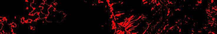


19 landslide extraction landslide: The soil areas in post-event image but not in pre-event image. Result: 39,499pixles 8% of all the image Soil areas of pre-event Soil areas of post-event Errors: The outline of cloud Errors of registration ti 19


20 Landslide extraction-2 (classification) Pre-event image Using supervised classification with 8 classes by maximum likelihood. Water1 Water2 Vegetation1 Vegetation2 Soil Rock1 Rock2 20


21 Post-event image Water1 Water2 Vegetation1g Vegetation2 Soil Shadow Rock2 21


22 Soil areas of pre-event Soil areas of post-event Soil areas of pre-event Soil areas of post-event 22


23 Extracted landslide by the difference of classifications Landslide : 80,971pixels 16% of all image Errors: Clouds Registrationi t ti Vegetation changes 23


24 Comparison landslide extraction by band threshold landslide extraction by classification 24

25 SRTM Applying 90m mesh SRTM data to show the postevent image by 3D. landslide lid occur on the slope of mountains. 25

")


26 Slope of SRTM Slope of Dem (in degrees) Dem data of this area 26


27 landslide extracted by band threshold landslide extracted by classification 27
28 Number of pixels Slope band threshold classification Slope (degree) Ratio of pixels The number of pixels with respect to the slope angle shows 80% 70% 60% 50% band threshold classification 40% that the ratio of pixels with respect to the slope angle has no clear trend. 30% 20% 10% 0% Slope (degree) 28
29 Conclusions River can be extracted by water s low NDVI value. In study area, water level raised due to soil dams. Landslide can be extracted by both band threshold h and classification. But the accuracy is not so high. The frequency of landslide increases as slope gets steeper. But the occurrence ratio of landslide is almost constant with the slope angle. 29
30 Future work High accuracy registration is needed. Other approaches for landslide lid extraction ti should be tested. Using ASTER DEM data to discuss the height change after the earthquake. Ak Acknowledgment ld All the ALOS data and products used in this study are owned by JAXA and provided from JAXA. 30
DAMAGE DETECTION OF THE 2008 SICHUAN, CHINA EARTHQUAKE FROM ALOS OPTICAL IMAGES
 DAMAGE DETECTION OF THE 2008 SICHUAN, CHINA EARTHQUAKE FROM ALOS OPTICAL IMAGES Wen Liu, Fumio Yamazaki Department of Urban Environment Systems, Graduate School of Engineering, Chiba University, 1-33,
CEOS Landslide Pilot Chinese Region:
 CEOS Working Group on Disasters Meeting #9 CEOS Landslide Pilot Chinese Region: a recent progress Ziyang Li zyli@aoe.ac.cn Key Laboratory of Quantitative Remote Sensing Information Technology, Academy
ESTIMATION OF LANDFORM CLASSIFICATION BASED ON LAND USE AND ITS CHANGE - Use of Object-based Classification and Altitude Data -
 ESTIMATION OF LANDFORM CLASSIFICATION BASED ON LAND USE AND ITS CHANGE - Use of Object-based Classification and Altitude Data - Shoichi NAKAI 1 and Jaegyu BAE 2 1 Professor, Chiba University, Chiba, Japan.
DETECTION OF CRUSTAL MOVEMENTS IN THE 2011 TOHOKU, JAPAN EARTHQUAKE USING HIGH-RESOLUTION SAR DATA
 Paper No. M-5 DETECTION OF CRUSTAL MOVEMENTS IN THE 2011 TOHOKU, JAPAN EARTHQUAKE USING HIGH-RESOLUTION SAR DATA Fumio Yamazaki 1 and Wen Liu 2 SUMMARY Significant crustal movements were caused by the
Need of Proper Development in Hilly Urban Areas to Avoid
 Need of Proper Development in Hilly Urban Areas to Avoid Landslide Hazard Dr. Arvind Phukan, P.E. Cosultant/Former Professor of Civil Engineering University of Alaska, Anchorage, USA RI District Governor
Pixel-based and object-based landslide mapping: a methodological comparison
 Pixel-based and object-based landslide mapping: a methodological comparison Daniel HÖLBLING 1, Tsai-Tsung TSAI 2, Clemens EISANK 1, Barbara FRIEDL 1, Chjeng-Lun SHIEH 2, and Thomas BLASCHKE 1 1 Department
STUDY ON FOREST VEGETATION CLASSIFICATION BASED ON MULTI- TEMPORAL REMOTE SENSING IMAGES
 STUDY ON FOREST VEGETATION CLASSIFICATION BASED ON MULTI- TEMPORAL REMOTE SENSING IMAGES Xia Jing 1, 2, JiHua Wang 2, WenJiang Huang 2,*, LiangYun Liu 2, JinDi Wang 1 1 School of Geography, Beijing Normal
Automatic Change Detection from Remote Sensing Stereo Image for Large Surface Coal Mining Area
 doi: 10.14355/fiee.2016.05.003 Automatic Change Detection from Remote Sensing Stereo Image for Large Surface Coal Mining Area Feifei Zhao 1, Nisha Bao 2, Baoying Ye 3, Sizhuo Wang 4, Xiaocui Liu 5, Jianyan
1 Introduction: 2 Data Processing:
 Darren Janzen University of Northern British Columbia Student Number 230001222 Major: Forestry Minor: GIS/Remote Sensing Produced for: Geography 413 (Advanced GIS) Fall Semester Creation Date: November
EXTRACTION OF FLOODED AREAS DUE THE 2015 KANTO-TOHOKU HEAVY RAINFALL IN JAPAN USING PALSAR-2 IMAGES
 EXTRACTION OF FLOODED AREAS DUE THE 2015 KANTO-TOHOKU HEAVY RAINFALL IN JAPAN USING PALSAR-2 IMAGES F. Yamazaki a, *, W. Liu a a Chiba University, Graduate School of Engineering, Chiba 263-8522, Japan
ESTIMATING LAND VALUE AND DISASTER RISK IN URBAN AREA IN YANGON, MYANMAR USING STEREO HIGH-RESOLUTION IMAGES AND MULTI-TEMPORAL LANDSAT IMAGES
 ESTIMATING LAND VALUE AND DISASTER RISK IN URBAN AREA IN YANGON, MYANMAR USING STEREO HIGH-RESOLUTION IMAGES AND MULTI-TEMPORAL LANDSAT IMAGES Tanakorn Sritarapipat 1 and Wataru Takeuchi 1 1 Institute
MONITORING OF GLACIAL CHANGE IN THE HEAD OF THE YANGTZE RIVER FROM 1997 TO 2007 USING INSAR TECHNIQUE
 MONITORING OF GLACIAL CHANGE IN THE HEAD OF THE YANGTZE RIVER FROM 1997 TO 2007 USING INSAR TECHNIQUE Hong an Wu a, *, Yonghong Zhang a, Jixian Zhang a, Zhong Lu b, Weifan Zhong a a Chinese Academy of
This is trial version
 Journal of Rangeland Science, 2012, Vol. 2, No. 2 J. Barkhordari and T. Vardanian/ 459 Contents available at ISC and SID Journal homepage: www.rangeland.ir Full Paper Article: Using Post-Classification
Evaluating the Vegetation Recovery in the Damage Area of Wenchuan Earthquake Using MODIS Data
 University of Nebraska - Lincoln DigitalCommons@University of Nebraska - Lincoln Community and Regional Planning Program: Faculty Scholarly and Creative Activity Community and Regional Planning Program
The Mountain Geohazard Assessment Model MoGAM
 Taj Haz Remote Geohazards Assessment in Tajikistan The Mountain Geohazard Assessment Model MoGAM Presented by Ingrid Kleinbauer University of Natural Resources and Applied Life Sciences, Vienna 1 Mountain
Result of DInSAR Analysis of Zentoku Landslide, Japan, and Development of Landslide Recognition Tool
 Result of DInSAR Analysis of Zentoku Landslide, Japan, and Development of Landslide Recognition Tool Ryoichi Furuta (RESTEC), Atsushi Yashima (Gifu Univ.), Kazuhide Sawada (Gifu Univ.), Hiroshi Fukuoka
INTRODUCTION OF A SUCCESS STORY IN THE PHILIPPINES
 INTRODUCTION OF A SUCCESS STORY IN THE PHILIPPINES Arturo S. Daag Department of Science and Technology Philippine Institute of Volcanology and Seismology (DOST-PHIVOLCS) Establishment of Sentinel Asia
GIS Application in Landslide Hazard Analysis An Example from the Shihmen Reservoir Catchment Area in Northern Taiwan
 GIS Application in Landslide Hazard Analysis An Example from the Shihmen Reservoir Catchment Area in Northern Taiwan Chyi-Tyi Lee Institute of Applied Geology, National Central University, No.300, Jungda
DETECTION OF CRUSTAL MOVEMENTS FOR THE 2011 TOHOKU, JAPAN EARTHQUAKE FROM MULTI-TEMPORAL HIGH- RESOLUTION SAR INTENSITY IMAGES
 Meccanica dei Materiali e delle Strutture Vol. 3 (2012), no.2, pp. 25-32 ISSN: 2035-679X Dipartimento di Ingegneria Civile, Ambientale, Aerospaziale, Dei Materiali DICAM DETECTION OF CRUSTAL MOVEMENTS
Digital Elevation Models (DEM) / DTM
 / DTM") Digital Elevation Models (DEM) / DTM Uses in remote sensing: queries and analysis, 3D visualisation, classification input Fogo Island, Cape Verde Republic ASTER DEM / image Banks Peninsula, Christchurch,
Digital Elevation Models (DEM) / DTM Uses in remote sensing: queries and analysis, 3D visualisation, classification input Fogo Island, Cape Verde Republic ASTER DEM / image Banks Peninsula, Christchurch,
STUDY ON KARST INFORMATION IDENTIFICATION OF QIANDONGNAN PREFECTURE BASED ON RS AND GIS TECHNOLOGY
 STUDY ON KARST INFORMATION IDENTIFICATION OF QIANDONGNAN PREFECTURE BASED ON RS AND GIS TECHNOLOGY Mingxing Yao 1, 2, Guoqing Zhou 1, *, Wei Wang 1, Zhiliang Wu 1, Yu Huang 1, Xiaomei Huang 1 1 Guangxi
GROUND SURFACE VISUALIZATION USING RED RELIEF IMAGE MAP FOR A VARIETY OF MAP SCALES
 GROUND SURFACE VISUALIZATION USING RED RELIEF IMAGE MAP FOR A VARIETY OF MAP SCALES T. Chiba a, B. Hasi a * a Asia Air Survey Co., Ltd., Kawasaki, Japan (has.baator, ta.chiba,)@ajiko.co.jp Commission II,
Digital Change Detection Using Remotely Sensed Data for Monitoring Green Space Destruction in Tabriz
 Int. J. Environ. Res. 1 (1): 35-41, Winter 2007 ISSN:1735-6865 Graduate Faculty of Environment University of Tehran Digital Change Detection Using Remotely Sensed Data for Monitoring Green Space Destruction
Emerging Needs, Challenges and Response Strategy
 Emerging Needs, Challenges and Response Strategy Development of Integrated Observing Systems in China JIAO Meiyan Deputy Administrator China Meteorological Administration September 2011 Geneva Outline
2013 Esri Europe, Middle East and Africa User Conference October 23-25, 2013 Munich, Germany
 2013 Esri Europe, Middle East and Africa User Conference October 23-25, 2013 Munich, Germany Environmental and Disaster Management System in the Valles Altos Region in Carabobo / NW-Venezuela Prof.Dr.habil.Barbara
Downloaded from Downloaded from
 IV SEMESTER BACK-PAPER EXAMINATION-2004 Q. [1] [a] Describe internal structure of the earth with a neat sketch. Write down the major land forms and their characteristics on the earth surface. [8] [b] What
Geospatial Approach for Delineation of Landslide Susceptible Areas in Karnaprayag, Chamoli district, Uttrakhand, India
 Geospatial Approach for Delineation of Landslide Susceptible Areas in Karnaprayag, Chamoli district, Uttrakhand, India Ajay Kumar Sharma & Anand Mohan Singh Overview Landslide - movement of a mass of rock,
Enhancements for FFGS improved operations
 Enhancements for FFGS improved operations Hydrologic Research Center 3-5 May 2017 3-5 May 2017 HRC CAFFG 1 Enhancements to be discussed A. Multiple Mesoscale Model Input B. Urban Flash Flood Warning C.
Data Quality and Uncertainty
 Data Quality and Uncertainty The power of GIS analysis is based on the assembly of layers of data, but as data layers increase, errors multiply - quality decreases. Garbage in, garbage out. High quality
The Relationship between Vegetation Changes and Cut-offs in the Lower Yellow River Based on Satellite and Ground Data
 Journal of Natural Disaster Science, Volume 27, Number 1, 2005, pp1-7 The Relationship between Vegetation Changes and Cut-offs in the Lower Yellow River Based on Satellite and Ground Data Xiufeng WANG
Module 2.1 Monitoring activity data for forests using remote sensing
 Module 2.1 Monitoring activity data for forests using remote sensing Module developers: Frédéric Achard, European Commission (EC) Joint Research Centre (JRC) Jukka Miettinen, EC JRC Brice Mora, Wageningen
Guillem Sòria, José A. Sobrino, Juan C. Jiménez-Muñoz, Mónica Gómez, Juan Cuenca, Mireia Romaguera and Malena Zaragoza
 Guillem Sòria, José A. Sobrino, Juan C. Jiménez-Muñoz, Mónica Gómez, Juan Cuenca, Mireia Romaguera and Malena Zaragoza University of Valencia, Spain MERIS (A)ATSR WORKSHOP ESRIN, Frascati, Italy 26-30
Ground motion attenuation relations of small and moderate earthquakes in Sichuan region
 Earthq Sci (2009)22: 277 282 277 Doi: 10.1007/s11589-009-0277-x Ground motion attenuation relations of small and moderate earthquakes in Sichuan region Lanchi Kang 1, and Xing Jin 1,2 1 Fuzhou University,
Change detection at the recently erupted Te Maari crater, Tongariro, from stereo aerial photographs
 Change detection at the recently erupted Te Maari crater, Tongariro, from stereo aerial photographs Strong, D.T., Jones, K.E., Ashraf, S. and Lee, J. Outline Geographic context Setting and eruption Science
Utilization of Global Map for Societal Benefit Areas
 Utilization of Global Map for Societal Benefit Areas The Fourth GEOSS AP Symposium Bali Indonesia, 11th March 2010 Shuhei Kojima Geographical Survey Institute Ministry of Land, Infrastructure, Transport
European Space Agency
 Guidelines - Guidelines how/when to interact during the WebEx session: - Due to the number of attendees, please keep always your webcam and microphone switched-off - You can use anytime the chat to all
Investigation and Assessment of Landslides and Debris Flows in Sichuan Province of China by Remote Sensing Technique
 Chinese Geographical Science 2006 16(3) 223 228 DOI 10.1007/s11769-006-0223-y www.springerlink.com Investigation and Assessment of Landslides and Debris Flows in Sichuan Province of China by Remote Sensing
Workshop on Drought and Extreme Temperatures: Preparedness and Management for Sustainable Agriculture, Forestry and Fishery
 Workshop on Drought and Extreme Temperatures: Preparedness and Management for Sustainable Agriculture, Forestry and Fishery 16-17 Feb.2009, Beijing, China Modeling Apple Tree Bud burst time and frost risk
Digital Elevation Model (DEM) Generation from Stereo Images
 Generation from Stereo Images") Pertanika J. Sci. & Technol. 19 (S): 77-82 (2011) ISSN: 0128-7680 Universiti Putra Malaysia Press Digital Elevation Model (DEM) Generation from Stereo Images C. E. Joanna Tan *, M. Z. Mat Jafri, H. S.
Pertanika J. Sci. & Technol. 19 (S): 77-82 (2011) ISSN: 0128-7680 Universiti Putra Malaysia Press Digital Elevation Model (DEM) Generation from Stereo Images C. E. Joanna Tan *, M. Z. Mat Jafri, H. S.
UGRC 144 Science and Technology in Our Lives/Geohazards
 UGRC 144 Science and Technology in Our Lives/Geohazards Session 3 Understanding Earthquakes and Earthquake Hazards Lecturer: Dr. Patrick Asamoah Sakyi Department of Earth Science, UG Contact Information:
RELATIONSHIP BETWEEN DAMAGE RATIO OF EXPRESSWAY EMBANKMENT AND SEISMIC INTENSITY IN THE 2004 MID-NIIGATA EARTHQUAKE
 the 8th Pacific Conference on Earthquake Engineering, Singapore, 27 RELATIONSHIP BETWEEN DAMAGE RATIO OF EXPRESSWAY EMBANKMENT AND SEISMIC INTENSITY IN THE 24 MID-NIIGATA EARTHQUAKE Yoshihisa Maruyama
Quantifying the hazard of catastrophic rock avalanches
 IRASMOS Symposium, Davos, Switzerland, 15-16 May 2008 Quantifying the hazard of catastrophic rock avalanches Acknowledging John J. Clague Ken Hewitt Reginald L. Hermanns Isaac J. Larsen Alexander L. Strom
Status and Data Applications of China Highresolution Earth Observation System. Earth Observation System and Data Center, CNSA Sep, 2016
 Status and Data Applications of China Highresolution Earth Observation System Earth Observation System and Data Center, CNSA Sep, 2016 Outlines Introduction Development of the Space-based System CHEOS
VULNERABILITY OF WATER SUPPLY TO NATURAL HAZARDS IN JAMAICA
 VULNERABILITY OF WATER SUPPLY TO NATURAL HAZARDS IN JAMAICA RAFI AHMAD rafi.ahmad@uwimona.edu.jm Unit for disaster studies, Department of Geography & Geology, The University of the West Indies, Mona Kingston
1. Introduction. Jai Kumar, Paras Talwar and Krishna A.P. Department of Remote Sensing, Birla Institute of Technology, Ranchi, Jharkhand, India
 Cloud Publications International Journal of Advanced Remote Sensing and GIS 2015, Volume 4, Issue 1, pp. 1026-1032, Article ID Tech-393 ISSN 2320-0243 Research Article Open Access Forest Canopy Density
Project title. Evaluation of MIR data from SPOT4/VEGETATION for the monitoring of climatic phenomena impact on vegetation
 Project title 1 Evaluation of MIR data from SPOT4/VEGETATION for the monitoring of climatic phenomena impact on vegetation Principal investigator: M-Christine IMBERTI Co-investigator: Frédéric BIARD Stockholm
CNES R&D and available software for Space Images based risk and disaster management
 CNES R&D and available software for Space Images based risk and disaster management 1/21 Contributors: CNES (Centre National d Etudes Spatiales), Toulouse, France Hélène Vadon Jordi Inglada 2/21 Content
Humanitarian Assistance and Disaster Relief (HADR)
") Humanitarian Assistance and Disaster Relief (HADR) Remote sensing, GIS & Server Technology for Planning, Response & Mitigation Jonathan Lee Hon Yip Senior Technical Sales, Intergraph Security, Government
Humanitarian Assistance and Disaster Relief (HADR) Remote sensing, GIS & Server Technology for Planning, Response & Mitigation Jonathan Lee Hon Yip Senior Technical Sales, Intergraph Security, Government
Geology 229 Engineering Geology Lecture 27. Earthquake Engineering (Reference West, Ch. 18)
") Geology 229 Engineering Geology Lecture 27 Earthquake Engineering (Reference West, Ch. 18) Earthquake Engineering 1. General introduction of earthquakes 2. Seismic Hazards 3. Strong ground motion Exactly
Geology 229 Engineering Geology Lecture 27 Earthquake Engineering (Reference West, Ch. 18) Earthquake Engineering 1. General introduction of earthquakes 2. Seismic Hazards 3. Strong ground motion Exactly
Mass Wasting. Mass Wasting. Earth s s External Processes
 1 Mass Wasting Presentation Modified from Instructor Resource Center on CD-ROM, Foundations of Earth Science, 4 th Edition, Lutgens & Tarbuck Mass Wasting 2 Down-slope movement of rock, loose material
Structural approach combining ALOS PALSAR linear feature extraction with field structural and geophysical investigations
 Structural approach combining ALOS PALSAR linear feature extraction with field structural and geophysical investigations 1 Veronika Kopačková, 1 Jan Franěk, 1 Kryštof Verner, 1 Karel Martínek, 2 Michal
An analysis on the relationship between land subsidence and floods at the Kujukuri Plain in Chiba Prefecture, Japan
 doi:10.5194/piahs-372-163-2015 Author(s) 2015. CC Attribution 3.0 License. An analysis on the relationship between land subsidence and floods at the Kujukuri Plain in Chiba Prefecture, Japan Y. Ito 1,
EFFECT OF ANCILLARY DATA ON THE PERFORMANCE OF LAND COVER CLASSIFICATION USING A NEURAL NETWORK MODEL. Duong Dang KHOI.
 EFFECT OF ANCILLARY DATA ON THE PERFORMANCE OF LAND COVER CLASSIFICATION USING A NEURAL NETWORK MODEL Duong Dang KHOI 1 10 Feb, 2011 Presentation contents 1. Introduction 2. Methods 3. Results 4. Discussion
Land cover/land use mapping and cha Mongolian plateau using remote sens. Title. Author(s) Bagan, Hasi; Yamagata, Yoshiki. Citation Japan.
 Bagan, Hasi; Yamagata, Yoshiki. Citation Japan.") Title Land cover/land use mapping and cha Mongolian plateau using remote sens Author(s) Bagan, Hasi; Yamagata, Yoshiki International Symposium on "The Imp Citation Region Specific Systems". 6 Nove Japan.
Title Land cover/land use mapping and cha Mongolian plateau using remote sens Author(s) Bagan, Hasi; Yamagata, Yoshiki International Symposium on "The Imp Citation Region Specific Systems". 6 Nove Japan.
EVALUATION OF SITE AMPLIFICATIONS IN JAPAN USING SEISMIC MOTION RECORDS AND A GEOMORPHOLOGIC MAP
 EVALUATION OF SITE AMPLIFICATIONS IN JAPAN USING SEISMIC MOTION RECORDS AND A GEOMORPHOLOGIC MAP Masaki Sakemoto a, Yoshihisa Maruyama b, and Fumio Yamazaki c a Graduate Student, Graduate School of Engineering,
Unit E: Planet Earth Topic 1: Scientific Study Helps Us Understand the Earth
 Unit E: Planet Earth Topic 1: Scientific Study Helps Us Understand the Earth 1 1.1 A Model for Earth A. Our Ancient Past 1. Geologists estimate that the Earth is about billion years old 2. Humans appeared
A Feasibility Study about Extraction Method of Densely Crowded Areaswith Wooden Buildings in the KOBE Government. Part II 1)
") A Feasibility Study about Extraction Method of Densely Crowded Areaswith Wooden Buildings in the KOBE Government. Part II 1) Consideration of evaluation of urban fire hazard. Ritsu KATAYAMA Dept. of Architecture,
A Feasibility Study about Extraction Method of Densely Crowded Areaswith Wooden Buildings in the KOBE Government. Part II 1) Consideration of evaluation of urban fire hazard. Ritsu KATAYAMA Dept. of Architecture,
FEM SEISMIC ANALYSIS ON THE EFFECT OF TOPOGRAPHY AND SLOPE STRUCTURE FOR LANDSLIDING POTENTIAL EVALUATION
 FEM SEISMIC ANALYSIS ON THE EFFECT OF TOPOGRAPHY AND SLOPE STRUCTURE FOR LANDSLIDING POTENTIAL EVALUATION Qi Wenhao Supervisor: Wang Fawu MEE10511 ABSTRACT In order to make clear the effect of topography
THE THEMATIC INFORMATION EXTRACTION FROM POLINSAR DATA FOR URBAN PLANNING AND MANAGEMENT
 THE THEMATIC INFORMATION EXTRACTION FROM POLINSAR DATA FOR URBAN PLANNING AND MANAGEMENT D.Amarsaikhan a, *, M.Sato b, M.Ganzorig a a Institute of Informatics and RS, Mongolian Academy of Sciences, av.enkhtaivan-54b,
Reassessing the conservation status of the giant panda using remote sensing
 SUPPLEMENTARY Brief Communication INFORMATION DOI: 10.1038/s41559-017-0317-1 In the format provided by the authors and unedited. Reassessing the conservation status of the giant panda using remote sensing
Using Weather and Climate Information for Landslide Prevention and Mitigation
 Using Weather and Climate Information for Landslide Prevention and Mitigation Professor Roy C. Sidle Disaster Prevention Research Institute Kyoto University, Japan International Workshop on Climate and
Digital Elevation Models (DEM) / DTM
 / DTM") Digital Elevation Models (DEM) / DTM Uses in remote sensing: queries and analysis, 3D visualisation, layers in classification Fogo Island, Cape Verde Republic ASTER DEM / image Banks Peninsula, Christchurch,
Digital Elevation Models (DEM) / DTM Uses in remote sensing: queries and analysis, 3D visualisation, layers in classification Fogo Island, Cape Verde Republic ASTER DEM / image Banks Peninsula, Christchurch,
Interpretive Map Series 24
 Oregon Department of Geology and Mineral Industries Interpretive Map Series 24 Geologic Hazards, and Hazard Maps, and Future Damage Estimates for Six Counties in the Mid/Southern Willamette Valley Including
Delineation of high landslide risk areas as a result of land cover, slope, and geology in San Mateo County, California
 Delineation of high landslide risk areas as a result of land cover, slope, and geology in San Mateo County, California Introduction Problem Overview This project attempts to delineate the high-risk areas
LAND DEGRADATION IN THE CARIBBEAN: QUATERNARY GEOLOGICAL PROCESSES. RAFI AHMAD
 EXTENDED TASK FORCE MEETING OF PARTICIPATING AGENCIES AND LATIN AMERICAN COUNTRIES FOR ENHANCING SOUTH-SOUTH COOPERATION BETWEEN LAC-CARIBBEAN SIDS PARTNERSHIP INITIATIVE ON LAND DEGRADATION AND SUSTAINABLE
Chapter 11 10/30/2013. Mass Wasting. Introduction. Factors That Influence Mass Wasting. Introduction. Factors That Influence Mass Wasting
 Introduction Chapter 11 Mass wasting - The downslope movement of material resulting from the force of gravity. Mass Wasting Mass wasting results when the force of gravity acting on a slope exceeds the
Estimation of Damage Ratios of Wooden Houses and Water Distribution Pipelines in an Earthquake Scenario for the Tokyo Metropolitan Region
 The 2011 World Congress on Advances in Structural Engineering and Mechanics (ASEM'11 + ) Seoul, Korea, 18-22 September, 2011 Estimation of Damage Ratios of Wooden Houses and Water Distribution Pipelines
DISASTER DAMAGE DETECTION AND ITS RECOVERY SUPPORT SYSTEM OF ROAD AND RAILROAD USING SATELLITE IMAGES
 International Archives of the Photogrammetry, Remote Sensing and Spatial Information Science, Volume XXXVIII, Part 8, Kyoto Japan 2010 DISASTER DAMAGE DETECTION AND ITS RECOVERY SUPPORT SYSTEM OF ROAD
TESTING ON THE TIME-ROBUSTNESS OF A LANDSLIDE PREDICTION MODEL. Hirohito Kojima* and Chang-Jo F. Chung**
 TESTING ON THE TIME-ROBUSTNESS OF A LANDSLIDE PREDICTION MODEL Hirohito Kojima* and Chang-Jo F. Chung** *: Science University of Tokyo, Remote Sensing Lab., Dept. of Civil Engineering 2641 Yamazaki, Noda-City,
Hua Zhang, Steven M. Gorelick, Nicolas Avisse, Amaury Tilmant, Deepthi Rajsekhar, and Jim Yoon
 Remote Sens. 216,, 735; doi:1.339/rs9735 S1 of S5 Supplementary Materials: A New Temperature- Vegetation Triangle Algorithm with Variable Edges (VE) for Satellite-Based Actual Evapotranspiration Estimation
River Response. Sediment Water Wood. Confinement. Bank material. Channel morphology. Valley slope. Riparian vegetation.
 River Response River Response Sediment Water Wood Confinement Valley slope Channel morphology Bank material Flow obstructions Riparian vegetation climate catchment vegetation hydrological regime channel
Geologic Hazards. Montour County Multi-jurisdictional. General. Earthquake
 Geologic Hazards General s are very rare in Pennsylvania and have caused little damage with no reported injuries or causalities. s that do occur in Pennsylvania happen deep within the Earth s crust. This
Crowdsourcing approach for large scale mapping of built-up land
 Crowdsourcing approach for large scale mapping of built-up land Kavinda Gunasekara Kavinda@ait.asia Geoinformatics Center Asian Institute of Technology, Thailand. Regional expert workshop on land accounting
GEOSPATIAL ANALYSIS OF GLACIAL DYNAMICS OF SHIGAR AND SHAYOK BASINS. Syed Naseem Abbas Gilany 1
 GEOSPATIAL ANALYSIS OF GLACIAL DYNAMICS OF SHIGAR AND SHAYOK BASINS 1 OUTLINE Introduction Problem Statement / Rationale Objectives Material and Methods Study Area Datasets Required Data Analysis / Assessment
Object Based Imagery Exploration with. Outline
 Object Based Imagery Exploration with Dan Craver Portland State University June 11, 2007 Outline Overview Getting Started Processing and Derivatives Object-oriented classification Literature review Demo
WATER BODIES V2 ALGORITHM
 26/03/2015 WATER BODIES V2 ALGORITHM USING PROBA-V 10 day mean composites multispectral data Water Bodies V2 PROBA-V µ-satellite, gap filler SPOT Sentinel PROBA-V S1-TOC synthesis products - full daily
Evaluating the information content of National ASTER Geoscience Maps in the Wagga Wagga and Cobar regions of New South Wales
 Evaluating the information content of National ASTER Geoscience Maps in the Wagga Wagga and Cobar regions of New South Wales The National ASTER Geoscience Maps, freely available from CSIRO/GA (https://data.csiro.au/dap/
LAB 5: LANDSLIDE RECOGNITION AND MAPPING
 Geology 350 1 LAB 5: LANDSLIDE RECOGNITION AND MAPPING OBJECTIVES: a. to learn to recognize and classify landslides on airphotos and topographic maps b. to learn to recognize landslide topography on topographic
Figure B.15 - Example of plotting the landslide potential points
 Figure B.15 - Example of plotting the landslide potential points Figure B.16 - Example of landslide potential map based on topographic factor in north area of kabupaten Jember 37 from 61 Figure B.17 -
3/8/17. #20 - Landslides: Mitigation and Case Histories. Questions for Thought. Questions for Thought
 #20 - Landslides: Mitigation and Case Histories Web Exercise #3 (Volcanoes) Due Wednesday There is a 2-point penalty for every day the assignment is late. Exam 1 Scores Scores and exam key are posted Vaiont
Defining microclimates on Long Island using interannual surface temperature records from satellite imagery
 Defining microclimates on Long Island using interannual surface temperature records from satellite imagery Deanne Rogers*, Katherine Schwarting, and Gilbert Hanson Dept. of Geosciences, Stony Brook University,
Flooding in Western North Carolina: Some Spatial, Hydrologic, and Seasonal Characteristics CAUTION!! Outline. Basic Flood Facts.
 Flooding in Western North Carolina: Some Spatial, Hydrologic, and Seasonal Characteristics J. Greg Dobson CAUTION!! National Environmental Modeling and Analysis Center RENCI at UNC-Asheville Engagement
Canadian Geo Course Introduction
 Canadian Geo 1202 Course Introduction Course Overview Unit 1 Natural and Human Systems (SCO 1.0 and SCO 2.0) - What happens when systems interact? In this unit students are challenged to reflect on the
Evaluating Flood Hazard Potential in Danang City, Vietnam Using FOSS4G
 Free and Open Source Software for Geospatial (FOSS4G) Conference Proceedings Volume 15 Seoul, South Korea Article 28 2015 Evaluating Flood Hazard Potential in Danang City, Vietnam Using FOSS4G An Tran
Vulnerability mapping for sustainable hazard mitigation in the city of Bukavu, South Kivu DRCongo
 IAG/AIG REGIONAL CONFERENCE, 18th to 22nd Feb. 2011 Vulnerability mapping for sustainable hazard mitigation in the city of Bukavu, South Kivu DRCongo Sadiki Ndyanabo 1, Ine Vandecasteele 2, Jan Moeyersons
Risk Assessment of Secondary Geological Disasters Induced by the Yushu Earthquake
 DOI: 10.1007/s11629-012-2076-4 Risk Assessment of Secondary Geological Disasters Induced by the Yushu Earthquake NIU Quanfu 1,2,3, CHENG Weiming 2 *, LIU Yong 1, XIE Yaowen 1, LAN Hengxing 2, CAO Yanrong
GLOBAL/CONTINENTAL LAND COVER MAPPING AND MONITORING
 GLOBAL/CONTINENTAL LAND COVER MAPPING AND MONITORING Ryutaro Tateishi, Cheng Gang Wen, and Jong-Geol Park Center for Environmental Remote Sensing (CEReS), Chiba University 1-33 Yayoi-cho Inage-ku Chiba
Uses of free satellite imagery for Disaster Risk Reduction (DRR)
") Centre of Applied Geoscience, Disaster Risk Reduction Research Group, School of Earth and Environmental Science, University of Portsmouth, UK Uses of free satellite imagery for Disaster Risk Reduction
Centre of Applied Geoscience, Disaster Risk Reduction Research Group, School of Earth and Environmental Science, University of Portsmouth, UK Uses of free satellite imagery for Disaster Risk Reduction
b. Why is the area affected by each earthquake circular or nearly circular? Where is the epicenter of each quake located?
 Name: Skill Sheet 29-A Interpreting Geologic Hazard Maps Plate tectonics and the weather are often the cause of geologic hazards such as earthquakes, volcanic eruptions, and flooding. Geologic hazard events
VISUALIZATION URBAN SPATIAL GROWTH OF DESERT CITIES FROM SATELLITE IMAGERY: A PRELIMINARY STUDY
 CO-439 VISUALIZATION URBAN SPATIAL GROWTH OF DESERT CITIES FROM SATELLITE IMAGERY: A PRELIMINARY STUDY YANG X. Florida State University, TALLAHASSEE, FLORIDA, UNITED STATES ABSTRACT Desert cities, particularly
water erosion lithosphere Describe the process of erosion and deposition. chemical weathering Dissolving limestone is an example of.
 At one time, there was one large island off the coast of Mississippi and now it is two separate islands. What caused the island to be split into two? water erosion The crust and the top part of the upper
GEOTECHNICAL DAMAGE ON THE 2017 IRAN IRAQ EARTHQUAKE. Prof. Miyajima Masakatsu & Hendra Setiawan February 15 th, 2018
 GEOTECHNICAL DAMAGE ON THE 2017 IRAN IRAQ EARTHQUAKE Prof. Miyajima Masakatsu & Hendra Setiawan February 15 th, 2018 Survey Geotechnical damage was found in the following location: Piran waterfall (Rock
Establishment of the watershed image classified rule-set and feasibility assessment of its application
 Establishment of the watershed classified rule-set and feasibility assessment of its application Cheng-Han Lin 1,*, Hsin-Kai Chuang 2 and Ming-Lang Lin 3, Wen-Chao Huang 4 1 2 3 Department of Civil Engineer,
AUTOMATED BUILDING DETECTION FROM HIGH-RESOLUTION SATELLITE IMAGE FOR UPDATING GIS BUILDING INVENTORY DATA
 13th World Conference on Earthquake Engineering Vancouver, B.C., Canada August 1-6, 2004 Paper No. 678 AUTOMATED BUILDING DETECTION FROM HIGH-RESOLUTION SATELLITE IMAGE FOR UPDATING GIS BUILDING INVENTORY
5.2 IDENTIFICATION OF HAZARDS OF CONCERN
 5.2 IDENTIFICATION OF HAZARDS OF CONCERN To provide a strong foundation for mitigation actions considered in Sections 6 and 9, County focused on considering a full range of s that could impact area, and
Physical Geography: Patterns, Processes, and Interactions, Grade 11, University/College Expectations
 Geographic Foundations: Space and Systems SSV.01 explain major theories of the origin and internal structure of the earth; Page 1 SSV.02 demonstrate an understanding of the principal features of the earth
SPATIAL MODELS FOR THE DEFINITION OF LANDSLIDE SUSCEPTIBILITY AND LANDSLIDE HAZARD. J.L. Zêzere Centre of Geographical Studies University of Lisbon
 SPATIAL MODELS FOR THE DEFINITION OF LANDSLIDE SUSCEPTIBILITY AND LANDSLIDE HAZARD J.L. Zêzere Centre of Geographical Studies University of Lisbon CONCEPTUAL MODEL OF LANDSLIDE RISK Dangerous Phenomena
Neeraj Kaushal 1, Kamal Kumar 2 Water Resources Department, PEC University of Technology, Chandigarh, India. IJRASET 2013: All Rights are Reserved
 Time Series Analysis of Glacial Lake in Western Himalayas Based on NDWI and MNDWI Neeraj Kaushal 1, Kamal Kumar 2 Water Resources Department, PEC University of Technology, Chandigarh, India Abstract This
Effects of different methods for estimating impervious surface cover on runoff estimation at catchment level
 Effects of different methods for estimating impervious surface cover on runoff estimation at catchment level Frank Canters 1, Jarek Chormanski 2, Tim Van de Voorde 1 and Okke Batelaan 2 1 Department of
Landslide Susceptibility Model of Tualatin Mountains, Portland Oregon. By Tim Cassese and Colby Lawrence December 10, 2015
 Landslide Susceptibility Model of Tualatin Mountains, Portland Oregon By Tim Cassese and Colby Lawrence December 10, 2015 Landslide Closes Highway 30 at St. John's Bridge Introduction: Study Area: Tualatin