Geospatial Approach for Delineation of Landslide Susceptible Areas in Karnaprayag, Chamoli district, Uttrakhand, India
|
|
|
- Amie Hodge
- 6 years ago
- Views:
Transcription


1 Geospatial Approach for Delineation of Landslide Susceptible Areas in Karnaprayag, Chamoli district, Uttrakhand, India Ajay Kumar Sharma & Anand Mohan Singh
2 Overview Landslide - movement of a mass of rock, debris or earth down a slope due to gravitational force India North-Eastern Himalayas highly prone to landslides come under very high to high hazard zones North-Eastern part of India render to highly landslide prone - Due to the complex geological setup with contemporary crustal adjustment, highly varying relief and ever increasing human interference The landslide susceptibility assessment was carried out based on the combination of maps in a GIS environment, considering the knowledge of local experts (Mariana Madruga de Brito, et.al., 2015). The present paper deals with thematic data layer generation and their spatial analysis in GIS environment for landslide susceptibility mapping


3 Data and Technology used Data Used: Resourcesat 1, LISS III satellite data from Bhuvan Cartosat DEM from Bhuvan GSI Geological Map Technology used: ArcGIS for data integration & analysis ENVI to generate slope aspect, slope degree etc.
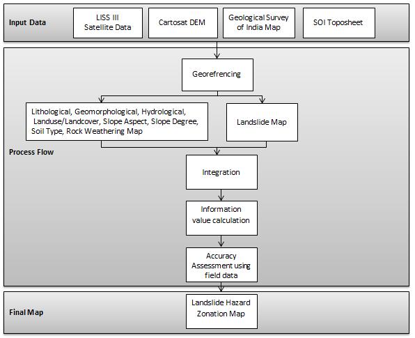
4 Methodology


5 Results For Landslide susceptibility mapping, following maps have been prepared using visual interpretation of satellite imagery Lithological Map Geomorphological Map Hydrological Map Soil Type Map Slope Aspect Map Slope Degree Map Structural Map Rock Weathering Map Landslide Map Landuse/Landcover Map
6 Information Value Calculation method Statistical method for spatial prediction of an event based on the parameters and event relationships. The Calculation for Information Value method area as follows: Where, DrA = SiA/Ni (1) NrA = StA / Nt (2) IV = log (NrA/(DrA) (3) DrA = Ratio of active slide area and total study area NrA = Ratio of active slide area and area of a particular unit in thematic map StA = Active Slide Area, Nt = Total Unit Area SiA = Total Active Slide Area, Ni = Study Area IV = Information Value More the total information value the more is the degree of landslide susceptibility.


7 Results Landslide hazard zonation map based on old and active slide S.No Landslide Hazard Zones Active Slide Old Slide 1 Very High Hazard Zone to to High Hazard Zone to to Moderate Hazard Zone to to Low Hazard Zone to to Very Low Hazard Zone < <
8 Results Hazard Zones Very High Hazard Zone Lithology Quartzite, Limestone slate, dolomitic limestone & slate Geomorphology Highly dissected denudostructural hill Slope Degree 45-60, >60 Slope Aspect N-W, N-E, W, N Facing Rock Weathering Moderate to very high Landuse/ Landcover Forest blank, Grass land, degraded land, degraded vegetation, build up area Soil type Loamy soil, Loamy skeletal soil High Hazard Zone Moderate Hazard Zone Slate with quartzite band & unconsolidated sediments Crystalline marble, Thin band of slate, Dolomatic crystalline limestone slate & quartzitic band, Dolomatic limestone & Slate metabascis, unconsolidated sediments Alluvial fans & Flood Plains Moderate dissected denude structural hill 25-35, >60 SW, W Facing N-W, S-W, E & N Facing Moderate Low to moderate Degraded vegetation, medium vegetation Agricultural land, degraded vegetation, build up area Loamy soil, Clayey soil, Loamy skeletal soil Loamy soil, Clayey soil, Loamy skeletal soil Low Hazard Zone Crystalline marble, Thin band of slate, Dolomatic crystalline limestone slate & quartzitic band, Low Dissected denudostructual hill N-E, N-W & E Facing Low to moderate Scrub grass land, Scrub land, Medium vegetation Loamy soil, Clayey soil, loamy skeletal soil Very Low Hazard Zone Quartzite & limestone River Terraces 0-15 Flat, N-W, W, E Facing Nil Barren Land, Dense vegetation, Rocky land Loamy Soil
9 Conclusion Landslide susceptibility evaluation involves a high level of uncertainty due to data limitations and model shortcomings The accuracy of susceptibility assessment is lower, when different types of slope movement are considered as a whole, because those landslides may have different spatial incidence, and distinct threshold conditions concerning preparatory factors This difficulty may be resolved by defining types of landslides prior to the susceptibility assessment. Different types of landslides are not equally conditioned by the instability factors. Information value scores show that lithological unit is the main preparatory condition for rotational movements Shallow translational slides have the strongest spatial correlation with slopes with gradients higher than 25
10 Conclusion In any event, different types of landslides neither have the same magnitude nor equal damaging potential. Deeper and larger slope movements (rotational and translational) may produce serious damage to properties and structures, while shallow translational slides are only responsible for minor road disruptions. The technical strategies to mitigate landsliding also depend on landslide typology. These are additional reasons to discriminate between different types of slope movements when assessing landslide susceptibility and hazard.
11 Discussion/ Q&A


12 To know more, visit us at: Or, write to us at:
Delineation of Landslide Susceptible Areas in Karnaprayag, Chamoli District, Uttarakhand, India Ajay Kumar Sharma 1, Anand Mohan Singh 2
 Delineation of Landslide Susceptible Areas in Karnaprayag, Chamoli District, Uttarakhand, India Ajay Kumar Sharma 1, Anand Mohan Singh 2 1 Project Manager, RMSI Pvt. Ltd. 2 Sr. Manager, RMSI Pvt. Ltd.
INTERNATIONAL JOURNAL OF GEOMATICS AND GEOSCIENCES Volume 1, No 1, 2010
 An Integrated Approach with GIS and Remote Sensing Technique for Landslide Hazard Zonation S.Evany Nithya 1 P. Rajesh Prasanna 2 1. Lecturer, 2. Assistant Professor Department of Civil Engineering, Anna
LANDSLIDE SUSCEPTIBILITY MAPPING USING INFO VALUE METHOD BASED ON GIS
 LANDSLIDE SUSCEPTIBILITY MAPPING USING INFO VALUE METHOD BASED ON GIS ABSTRACT 1 Sonia Sharma, 2 Mitali Gupta and 3 Robin Mahajan 1,2,3 Assistant Professor, AP Goyal Shimla University Email: sonia23790@gmail.com
Landslide Disasters in Uttarakhand: A Case of Landslide Susceptibility Zonation of Alaknanda Valley in Garhwal Himalaya
 Global Journal of Current Research Vol. 2 No. 1. 2013. Pp. 19-26 Copyright by CRDEEP. All Rights Reserved. Full Length Research Paper Landslide Disasters in Uttarakhand: A Case of Landslide Susceptibility
Using Weather and Climate Information for Landslide Prevention and Mitigation
 Using Weather and Climate Information for Landslide Prevention and Mitigation Professor Roy C. Sidle Disaster Prevention Research Institute Kyoto University, Japan International Workshop on Climate and
International Journal of Modern Trends in Engineering and Research e-issn No.: , Date: April, 2016
 International Journal of Modern Trends in Engineering and Research www.ijmter.com e-issn No.:2349-9745, Date: 28-30 April, 2016 Landslide Hazard Management Maps for Settlements in Yelwandi River Basin,
SPATIAL MODELS FOR THE DEFINITION OF LANDSLIDE SUSCEPTIBILITY AND LANDSLIDE HAZARD. J.L. Zêzere Centre of Geographical Studies University of Lisbon
 SPATIAL MODELS FOR THE DEFINITION OF LANDSLIDE SUSCEPTIBILITY AND LANDSLIDE HAZARD J.L. Zêzere Centre of Geographical Studies University of Lisbon CONCEPTUAL MODEL OF LANDSLIDE RISK Dangerous Phenomena
2013 Esri Europe, Middle East and Africa User Conference October 23-25, 2013 Munich, Germany
 2013 Esri Europe, Middle East and Africa User Conference October 23-25, 2013 Munich, Germany Environmental and Disaster Management System in the Valles Altos Region in Carabobo / NW-Venezuela Prof.Dr.habil.Barbara
Need of Proper Development in Hilly Urban Areas to Avoid
 Need of Proper Development in Hilly Urban Areas to Avoid Landslide Hazard Dr. Arvind Phukan, P.E. Cosultant/Former Professor of Civil Engineering University of Alaska, Anchorage, USA RI District Governor
INTERNATIONAL JOURNAL OF GEOMATICS AND GEOSCIENCES Volume 2, No 2, 2011
 INTERNATIONAL JOURNAL OF GEOMATICS AND GEOSCIENCES Volume 2, No 2, 2011 Copyright 2010 All rights reserved Integrated Publishing services Research article ISSN 0976 4380 Geomorphological study of Atagad
Landslide Hazard Investigation in Papua New Guinea-A Remote Sensing & GIS Approach
 Landslide Hazard Investigation in Papua New Guinea-A Remote Sensing & GIS Approach Sujoy Kumar Jana 1, Tingneyuc Sekac 2, Dilip Kumar Pal 3 Abstract: Tribal communities living in the mountainous regions
Grant 0299-NEP: Water Resources Project Preparatory Facility
 Document Produced under Grant Project Number: 45206 May 2016 Grant 0299-NEP: Water Resources Project Preparatory Facility Final Report Volume 3 East Rapti (1 of 9) Prepared by Pvt. Ltd. For Ministry of
INTRODUCTION. Climate
 INTRODUCTION Climate Landslides are serious natural disasters in many parts of the world. Since the past 30 years, rainfall triggered landslides and debris flows had been one of the natural disasters of
Down-stream process transition (f (q s ) = 1)
 = 1)") Down-stream process transition (f (q s ) = 1) Detachment Limited S d >> S t Transport Limited Channel Gradient (m/m) 10-1 Stochastic Variation { Detachment Limited Equilibrium Slope S d = k sd A -θ d S
Down-stream process transition (f (q s ) = 1) Detachment Limited S d >> S t Transport Limited Channel Gradient (m/m) 10-1 Stochastic Variation { Detachment Limited Equilibrium Slope S d = k sd A -θ d S
LANDSLIDE HAZARD ZONATION IN AND AROUND KEDARNATH REGION AND ITS VALIDATION BASED ON REAL TIME KEDARNATH DISASTER USING GEOSPATIAL TECHNIQUES
 LANDSLIDE HAZARD ZONATION IN AND AROUND KEDARNATH REGION AND ITS VALIDATION BASED ON REAL TIME KEDARNATH DISASTER USING GEOSPATIAL TECHNIQUES Divya Uniyal 1,*, Saurabh Purohit 2, Sourabh Dangwal 1, Ashok
CHAPTER 3 LANDSLIDE HAZARD ZONATION
 43 CHAPTER 3 LANDSLIDE HAZARD ZONATION 3.1 GENERAL Landslide hazard is commonly shown on maps, which display the spatial distribution of hazard classes (Landslide Hazard Zonation). Landslide hazard zonation
Journal of Environmental Research And Development Vol. 5 No. 1, July-September 2010
 MODELLING OF GROUND WATER POTENTIAL ZONES USING REMOTE SENSING AND GIS TECHNIQUE : A CASE STUDY FOR HOSUR UNION, KRISHNAGIRI DISTRICT, TAMIL NADU, INDIA L.Yeshodha*, H.N.Rajakumara, S. Arunachalam 1 and
LANDSLIDE HAZARDS. presented during the. TRAINING-WORKSHOP ON DISASTER RISK MANAGEMENT Rakdell Inn Virac, Catanduanes 03 July 2008
 LANDSLIDE HAZARDS presented during the TRAINING-WORKSHOP ON DISASTER RISK MANAGEMENT Rakdell Inn Virac, Catanduanes 03 July 2008 GEOLOGIC HAZARDS the probability of occurrence, within a specific period
IDENTIFICATION OF LANDSLIDE-PRONE AREAS USING REMOTE SENSING TECHNIQUES IN SILLAHALLAWATERSHED, NILGIRIS DISTRICT,TAMILNADU,INDIA
 IDENTIFICATION OF LANDSLIDE-PRONE AREAS USING REMOTE SENSING TECHNIQUES IN SILLAHALLAWATERSHED, NILGIRIS DISTRICT,TAMILNADU,INDIA J.Jayanthi 1, T.Naveen Raj 2, M.Suresh Gandhi 3, 1 Research Scholar, Department
APPLICATION OF REMOTE SENSING & GIS ON LANDSLIDE HAZARD ZONE IDENTIFICATION & MANAGEMENT
 APPLICATION OF REMOTE SENSING & GIS ON LANDSLIDE HAZARD ZONE IDENTIFICATION & MANAGEMENT PRESENTED BY SUPRITI PRAMANIK M.TECH IN ENVIRONMENTAL SCIENCE AND TECHNOLOGY NIT,DURGAPUR 25-04-2015 1 INTRODUCTION
Introduction. About the Author:
 Remote sensing and GIS for Landslide Hazard Mapping in India - A Review 1 Er. Balwinder Lallotra, 2 Dr. Bushra Zaman 1,2 Department of Civil Engineering, MM University, Sadopur, Ambala Abstract: Landslides
Hydrological parameters Controls Vulnerable Zones in Calicut Nilambur Gudalur Ghat section, Gudalur, The Nilgiris, Tamil Nadu.
 International Journal of ChemTech Research CODEN (USA): IJCRGG ISSN: 0974-4290 Vol.9, No.03 pp 248-253, 2016 Hydrological parameters Controls Vulnerable Zones in Calicut Nilambur Gudalur Ghat section,
ASTER DEM Based Studies for Geological and Geomorphological Investigation in and around Gola block, Ramgarh District, Jharkhand, India
 International Journal of Scientific & Engineering Research, Volume 3, Issue 2, February-2012 1 ASTER DEM Based Studies for Geological and Geomorphological Investigation in and around Gola block, Ramgarh
INTERNATIONAL JOURNAL OF GEOMATICS AND GEOSCIENCES Volume 3, No 1, 2012
 INTERNATIONAL JOURNAL OF GEOMATICS AND GEOSCIENCES Volume 3, No 1, 2012 Copyright by the authors - Licensee IPA- Under Creative Commons license 3.0 Research article ISSN 0976 4380 Geo-Hydrological study
IDENTIFICATION OF LANDSLIDE-PRONE AREAS USING REMOTE SENSING TECHNIQUES
 5.1 IDENTIFICATION OF LANDSLIDE-PRONE AREAS USING REMOTE SENSING TECHNIQUES P.V. Seethapathi National Institute of Hydrology Jal Vigyan Bhawan, Roorkee-247 667, Uttarakhand Email: neriwalam@gwl.net.in
Landslides Zones of Nearby Areas of Malin Village, Pune District, Maharashtra Using GIS Techniques
 Landslides Zones of Nearby Areas of Malin Village, Pune District, Maharashtra Using GIS Techniques Pooja Gujarathi 1, S. J. Mane 2 1 Savitribai Phule Pune University, D. Y. Patil College of Engineering,
Virtual Reality Modeling of Landslide for Alerting in Chiang Rai Area Banphot Nobaew 1 and Worasak Reangsirarak 2
 Virtual Reality Modeling of Landslide for Alerting in Chiang Rai Area Banphot Nobaew 1 and Worasak Reangsirarak 2 1 Banphot Nobaew MFU, Chiang Rai, Thailand 2 Worasak Reangsirarak MFU, Chiang Rai, Thailand
EFFECT OF WATERSHED DEVELOPMENT PROGRAMME IN GUDHA GOKALPURA VILLAGE, BUNDI DISTRICT, RAJASTHAN - A REMOTE SENSING STUDY
 EFFECT OF WATERSHED DEVELOPMENT PROGRAMME IN GUDHA GOKALPURA VILLAGE, BUNDI DISTRICT, RAJASTHAN - A REMOTE SENSING STUDY G. Sajeevan, C. P. Johnson, D. J. Pal and B. K. Kakade* C-DAC, Pune University Campus,
Landuse/Landcover Change Detection in Umshing- Mawkynroh of East Khasi Hills District, Meghalaya Using Spatial Information Technology
 International Journal of Scientific and Research Publications, Volume 6, Issue 1, January 2016 197 Landuse/Landcover Change Detection in Umshing- Mawkynroh of East Khasi Hills District, Meghalaya Using
GIS Based Delineation of Micro-watershed and its Applications: Mahendergarh District, Haryana
 Kamla-Raj 2012 J Hum Ecol, 38(2): 155-164 (2012) GIS Based Delineation of Micro-watershed and its Applications: Mahendergarh District, Haryana Gulshan Mehra and Rajeshwari * Department of Geography, Kurukshetra
MAPPING POTENTIAL LAND DEGRADATION IN BHUTAN
 MAPPING POTENTIAL LAND DEGRADATION IN BHUTAN Moe Myint, Geoinformatics Consultant Rue du Midi-8, CH-1196, Gland, Switzerland moemyint@bluewin.ch Pema Thinley, GIS Analyst Renewable Natural Resources Research
BASIC DETAILS. Morphometric features for landslide zonation A case study for Ooty Mettupalayam highway
 BASIC DETAILS Paper reference number : MWF PN 121 Title of the paper Name of the Presenter Author affiliation Mailing address Email address : Extraction of Topographic and Morphometric features for landslide
2014 Summer Training Courses on Slope Land Disaster Reduction Hydrotech Research Institute, National Taiwan University, Taiwan August 04-15, 2014
 Final Project Report 2014 Summer Training Courses on Slope Land Disaster Reduction Hydrotech Research Institute, National Taiwan University, Taiwan August 04-15, 2014 Landslides in Mt. Umyeon Susceptibility
Landslide Hazard Assessment Methodologies in Romania
 A Scientific Network for Earthquake, Landslide and Flood Hazard Prevention SciNet NatHazPrev Landslide Hazard Assessment Methodologies in Romania In the literature the terms of susceptibility and landslide
Assessment of solid load and siltation potential of dams reservoirs in the High Atlas of Marrakech (Moorcco) using SWAT Model
 using SWAT Model") Assessment of solid load and siltation potential of dams reservoirs in the High Atlas of Marrakech (Moorcco) using SWAT Model Amal Markhi: Phd Student Supervisor: Pr :N.Laftrouhi Contextualization Facing
Assessment of solid load and siltation potential of dams reservoirs in the High Atlas of Marrakech (Moorcco) using SWAT Model Amal Markhi: Phd Student Supervisor: Pr :N.Laftrouhi Contextualization Facing
Debris flow: categories, characteristics, hazard assessment, mitigation measures. Hariklia D. SKILODIMOU, George D. BATHRELLOS
 Debris flow: categories, characteristics, hazard assessment, mitigation measures Hariklia D. SKILODIMOU, George D. BATHRELLOS Natural hazards: physical phenomena, active in geological time capable of producing
LandslideHazardZonationusingQuantitativeMethodsinGISPauriGarhwalDistrictUttarakhandIndia
 Global Journal of Science Frontier Research: H Environment & Earth Science Volume 16 Issue 4 Version 1.0 Year 2016 Type : Double Blind Peer Reviewed International Research Journal Publisher: Global Journals
Landslide Hazard Mapping of Nagadhunga-Naubise Section of the Tribhuvan Highway in Nepal with GIS Application
 Journal of Geographic Information System, 2014, 6, 723-732 Published Online December 2014 in SciRes. http://www.scirp.org/journal/jgis http://dx.doi.org/10.4236/jgis.2014.66059 Landslide Hazard Mapping
EMERGENCY PLANNING IN NORTHERN ALGERIA BASED ON REMOTE SENSING DATA IN RESPECT TO TSUNAMI HAZARD PREPAREDNESS
 EMERGENCY PLANNING IN NORTHERN ALGERIA BASED ON REMOTE SENSING DATA IN RESPECT TO TSUNAMI HAZARD PREPAREDNESS Barbara Theilen-Willige Technical University of Berlin, Institute of Applied Geosciences Department
Description of Simandou Archaeological Potential Model. 12A.1 Overview
 12A Description of Simandou Archaeological Potential Model 12A.1 Overview The most accurate and reliable way of establishing archaeological baseline conditions in an area is by conventional methods of
Pinyol, Jordi González, Marta Oller, Pere Corominas, Jordi Martínez, Pere
 Rockfall hazard mapping methodology applied to the Geological Hazard Prevention Map in Catalonia 1:25000 Pinyol, Jordi González, Marta Oller, Pere Corominas, Jordi Martínez, Pere ROCKFALL HAZARD MAPPING
Landslide hazards zonation using GIS in Khoramabad, Iran
 Journal of Geotechnical Geology Winter 04, Vol. 9, No. 4: 4- www.geo-tech.ir Landslide hazards zonation using GIS in Khoramabad, Iran G. R. Khanlari *, Y. Abdilor & R. Babazadeh ) Associate Prof., Department
Georeferencing and Satellite Image Support: Lessons learned, Challenges and Opportunities
 Georeferencing and Satellite Image Support: Lessons learned, Challenges and Opportunities Shirish Ravan shirish.ravan@unoosa.org UN-SPIDER United Nations Office for Outer Space Affairs (UNOOSA) UN-SPIDER
Watershed Development Prioritization by Applying WERM Model and GIS Techniques in Takoli Watershed of District Tehri (Uttarakhand)
") Watershed Development Prioritization by Applying WERM Model and GIS Techniques in Takoli Watershed of District Tehri (Uttarakhand) Anju Panwar Uttarakhand Space Application Centre Dehradun, Uttarkhand
Watershed Development Prioritization by Applying WERM Model and GIS Techniques in Takoli Watershed of District Tehri (Uttarakhand) Anju Panwar Uttarakhand Space Application Centre Dehradun, Uttarkhand
Delineation of groundwater potential zones in Coimbatore district, Tamil Nadu, using Remote sensing and GIS techniques
 Delineation of groundwater potential zones in Coimbatore district, Tamil Nadu, using Remote sensing and GIS techniques Vasudevan S*, MUNGANYINKA Jeanne Pauline, Balamurugan P, Sumanta Kumar Sahoo and Ashis
Dr. S.SURIYA. Assistant professor. Department of Civil Engineering. B. S. Abdur Rahman University. Chennai
 Hydrograph simulation for a rural watershed using SCS curve number and Geographic Information System Dr. S.SURIYA Assistant professor Department of Civil Engineering B. S. Abdur Rahman University Chennai
Data Mining Approach For Landslide Susceptibility Mapping For Kundhapallam Watershed, Nilgiris, TamilNadu Dr. P. Rajesh Prasanna 1, S.
 Data Mining Approach For Landslide Susceptibility Mapping For Kundhapallam Watershed, Nilgiris, TamilNadu Dr. P. Rajesh Prasanna 1, S.Evany Nithya 2 1 Professor, Anna University Tiruchirappalli 2 Asst.
Remote Sensing and GIS Applications for Hilly Watersheds SUBASHISA DUTTA DEPARTMENT OF CIVIL ENGINEERING IIT GUWAHATI
 Remote Sensing and GIS Applications for Hilly Watersheds SUBASHISA DUTTA DEPARTMENT OF CIVIL ENGINEERING IIT GUWAHATI Deciding Alternative Land Use Options in a Watershed Using GIS Source: Anita Prakash
REMOTE SENSING AND GIS BASED APPROACH FOR DELINEATION OF ARTIFICIAL RECHARGE SITES IN PALANI TALUK, DINDIGUL DISTRICT, TAMILNADU, INDIA
 International Journal of Civil Engineering and Technology (IJCIET) Volume 8, Issue 8, August 2017, pp. 698 706, Article ID: IJCIET_08_08_070 Available online at http://http://www.iaeme.com/ijciet/issues.asp?jtype=ijciet&vtype=8&itype=8
INTERNATIONAL JOURNAL OF GEOMATICS AND GEOSCIENCES Volume 2, No 1, 2011
 INTERNATIONAL JOURNAL OF GEOMATICS AND GEOSCIENCES Volume 2, No 1, 2011 Copyright 2010 All rights reserved Integrated Publishing services Research article ISSN 0976 4380 Hypsometric Analysis of Varattaru
GIS Application in Landslide Hazard Analysis An Example from the Shihmen Reservoir Catchment Area in Northern Taiwan
 GIS Application in Landslide Hazard Analysis An Example from the Shihmen Reservoir Catchment Area in Northern Taiwan Chyi-Tyi Lee Institute of Applied Geology, National Central University, No.300, Jungda
GROUNDWATER CONFIGURATION IN THE UPPER CATCHMENT OF MEGHADRIGEDDA RESERVOIR, VISAKHAPATNAM DISTRICT, ANDHRA PRADESH
 GROUNDWATER CONFIGURATION IN THE UPPER CATCHMENT OF MEGHADRIGEDDA RESERVOIR, VISAKHAPATNAM DISTRICT, ANDHRA PRADESH Prof.P.Jagadeesara Rao Department of Geo-Engineering and Centre for Remote Sensing, College
Comparison of Geomatics Approach and Mathematical Model in Assessment of Soil Erosion Prone Areas Kolli Hills, Namakkal District Tamilnadu, India
 Cloud Publications International Journal of Advanced Earth Science and Engineering 2013, Volume 2, Issue 1, pp. 43-56, Article ID Sci-20 Research Article Open Access Comparison of Geomatics Approach and
About the present study
 About the present study This study presents results obtained under the project Models of contemporary Periglacial Morphogenesis a first stage of Bulgarian Periglacial Programme a programme for observation
Landslide hazard zonation (LHZ) mapping on meso-scale for systematic town planning in mountainous terrain
 mapping on meso-scale for systematic town planning in mountainous terrain") Journal of Scientific & Industrial Research 486 Vol. 67, July 2008, pp. 486-497 J SCI IND RES VOL 67 JULY 2008 Landslide hazard zonation (LHZ mapping on meso-scale for systematic town planning in mountainous
Journal of Scientific & Industrial Research 486 Vol. 67, July 2008, pp. 486-497 J SCI IND RES VOL 67 JULY 2008 Landslide hazard zonation (LHZ mapping on meso-scale for systematic town planning in mountainous
About the Author: Abstract:
 Identification of groundwater prospecting zones using Remote Sensing and GIS techniques in upper Vena river watersheds Nagpur district, Maharashtra, India B.S. Manjare Department of Geology RTM Nagpur
LANDSLIDE HAZARD ZONATION USING THE RELATIVE EFFECT METHOD IN SOUTH EASTERN PART OF NILGIRIS, TAMILNADU, INDIA.
 LANDSLIDE HAZARD ZONATION USING THE RELATIVE EFFECT METHOD IN SOUTH EASTERN PART OF NILGIRIS, TAMILNADU, INDIA. Naveen Raj, T* Research scholar, Department of Geology, University of Madras, Maraimalai
A National Scale Landslide Susceptibility Assessment for St. Lucia, Caribbean Sea
 A National Scale Landslide Susceptibility Assessment for St. Lucia, Caribbean Sea Submitted by James Varghese As a part of M.Sc. Module On Empirical Modeling of Hazard Processes TABLE OF CONTENTS INTRODUCTION...
Dan Miller + Kelly Burnett, Kelly Christiansen, Sharon Clarke, Lee Benda. GOAL Predict Channel Characteristics in Space and Time
 Broad-Scale Models Dan Miller + Kelly Burnett, Kelly Christiansen, Sharon Clarke, Lee Benda GOAL Predict Channel Characteristics in Space and Time Assess Potential for Fish Use and Productivity Assess
Landslide Hazard Zonation Methods: A Critical Review
 International Journal of Civil Engineering Research. ISSN 2278-3652 Volume 5, Number 3 (2014), pp. 215-220 Research India Publications http://www.ripublication.com/ijcer.htm Landslide Hazard Zonation Methods:
HYDROGEOLOGICAL EVOLUTION OF PAGERU RIVER BASIN, INDIA: AN INTEGRATED APPROACH USING REMOTE SENSING, GEOPHYSICAL DATA
 1 HYDROGEOLOGICAL EVOLUTION OF PAGERU RIVER BASIN, INDIA: AN INTEGRATED APPROACH USING REMOTE SENSING, GEOPHYSICAL DATA P.D.SREEDEVI IFCGR, National Geophysical Research Institute, Mailbox no. 77, Uppal
LANDSLIDE HAZARD AND ITS MAPPING USING REMOTE SENSING AND GIS
 Journal of Scientific Research Vol. 58, 2014 : 1-13 Banaras Hindu University, Varanasi ISSN : 0447-9483 LANDSLIDE HAZARD AND ITS MAPPING USING REMOTE SENSING AND GIS Praveen Kumar Rai 1*, Kshitij Mohan
Result of Field Geological Survey and Ground Truth for the Analysis Date: 2007/7/5 Location (UTM) Elev Geological Unit Point No. NT-02 VSW Index 260,7
 Elev Geological Unit Point No. NT-02 VSW Index 260,7") Date: Point No. 2007/7/5 NT-01 Result of Field Geological Survey and Ground Truth for the Analysis Location (UTM) Topography of granite hill in flat land Lithology: Medium grained hornblende granite. Topography:
Date: Point No. 2007/7/5 NT-01 Result of Field Geological Survey and Ground Truth for the Analysis Location (UTM) Topography of granite hill in flat land Lithology: Medium grained hornblende granite. Topography:
Evaluation of groundwater potential zones in Krishnagiri District, Tamil Nadu using MIF Technique
 Evaluation of groundwater potential zones in Krishnagiri District, Tamil Nadu using MIF Technique Manikandan.J 1, Kiruthika.A.M 2, S.Sureshbabu 3 Student, M.Tech Remote sensing, Adhiyamaan College Of Engineering,
Eagle Creek Post Fire Erosion Hazard Analysis Using the WEPP Model. John Rogers & Lauren McKinney
 Eagle Creek Post Fire Erosion Hazard Analysis Using the WEPP Model John Rogers & Lauren McKinney Columbia River Gorge at Risk: Using LiDAR and GIS-based predictive modeling for regional-scale erosion susceptibility
FAILURES IN THE AMAZON RIVERBANKS, IQUITOS, PERU
 FAILURES IN THE AMAZON RIVERBANKS, IQUITOS, PERU A.Carrillo-Gil University of Engineering & A.Carrillo Gil S.A.,Consulting Engineering,Lima,Peru L. Dominguez University of Engineering,Lima & The Maritime
DEVELOPMENT OF FLOOD HAZARD VULNERABILITY MAP FOR ALAPPUZHA DISTRICT
 DEVELOPMENT OF FLOOD HAZARD VULNERABILITY MAP FOR ALAPPUZHA DISTRICT Ciya Maria Roy 1, Elsa Manoj 2, Harsha Joy 3, Sarin Ravi 4, Abhinanda Roy 5 1,2,3,4 U.G. Student, Department of Civil Engineering, MITS
Copernicus Overview. Major Emergency Management Conference Athlone 2017
 Copernicus Overview Major Emergency Management Conference Athlone 2017 Copernicus is a European programme implemented by the European Commission. The services address six thematic areas: land, marine,
Outline. Remote Sensing, GIS and DEM Applications for Flood Monitoring. Introduction. Satellites and their Sensors used for Flood Mapping
 Outline Remote Sensing, GIS and DEM Applications for Flood Monitoring Prof. D. Nagesh Kumar Chairman, Centre for Earth Sciences Professor, Dept. of Civil Engg. Indian Institute of Science Bangalore 560
Erosion Susceptibility in the area Around the Okanogan Fire Complex, Washington, US
 Erosion Susceptibility in the area Around the Okanogan Fire Complex, Washington, US 1. Problem Construct a raster that represents susceptibility to erosion based on lithology, slope, cover type, burned
Applying Hazard Maps to Urban Planning
 Applying Hazard Maps to Urban Planning September 10th, 2014 SAKAI Yuko Disaster Management Expert JICA Study Team for the Metro Cebu Roadmap Study on the Sustainable Urban Development 1 Contents 1. Outline
International Journal of Intellectual Advancements and Research in Engineering Computations
 ISSN:2348-2079 Volume-5 Issue-2 International Journal of Intellectual Advancements and Research in Engineering Computations Agricultural land investigation and change detection in Coimbatore district by
Geospatial Data Integration For Groundwater Recharge Estimation In Hard Rock Terrain. Authors,
 Geospatial Data Integration For Groundwater Recharge Estimation In Hard Rock Terrain Authors, Dr. Y. B. Katpatal Assistant Professor Department of Civil Engineering, Visvesvaraya National Institute of
LANDSLIDE HAZARD EVALUATION AND A STUDY ON INFLUENCE OF NEOTECTONIC LINEAMENTS
 Chapter - 6 LANDSLIDE HAZARD EVALUATION AND A STUDY ON INFLUENCE OF NEOTECTONIC LINEAMENTS 6.1 GENERAL The study area is bounded by hills like Shevaroys, Chitteri and Kalrayan in the north and Kolli and
LAND SUITABILITY STUDY IN LAND DEGRADED AREA DUE TO MINING IN DHANBAD DISTRICT, JHARKHAND.
 LAND SUITABILITY STUDY IN LAND DEGRADED AREA DUE TO MINING IN DHANBAD DISTRICT, JHARKHAND. Saranathan, E a*, Loveson, V.J b. and Victor Rajamanickam, G c a School of Civil Engineering, SASTRA, Thanjavur
Landslide susceptibility mapping using frequency ratio method and GIS in south eastern part of Nilgiri District, Tamilnadu, India
 susceptibility mapping using frequency ratio method and GIS in south eastern part of Nilgiri District, Tamilnadu, India Ram Mohan.V 1, Jeyaseelan.A 1, Naveen Raj.T 1, Narmatha.T 1, Jayaprakash.M 2 1 Department
Delineation of Groundwater Potential Zone on Brantas Groundwater Basin
 Delineation of Groundwater Potential Zone on Brantas Groundwater Basin Andi Rachman Putra 1, Ali Masduqi 2 1,2 Departement of Environmental Engineering, Sepuluh Nopember Institute of Technology, Indonesia
Assessment of Urban Geomorphological Hazard in the North-East of Cairo City, Using Remote Sensing and GIS Techniques. G. Albayomi
 Assessment of Urban Geomorphological Hazard in the North-East of Cairo City, Using Remote Sensing and GIS Techniques G. Albayomi Geography Department, Faculty of Arts, Helwan University, Cairo, Egypt Gehan_albayomi@arts.helwan.edu.eg
Paper presented in the Annual Meeting of Association of American Geographers, Las Vegas, USA, March 2009 ABSTRACT
 Paper presented in the Annual Meeting of Association of American Geographers, Las Vegas, USA, March 2009 ABSTRACT CHANGING GEOMORPHOLOGY OF THE KOSI RIVER SYSTEM IN THE INDIAN SUBCONTINENT Nupur Bose,
MANAGEMENT OF LARGE MUDSLIDES
 36 MANAGEMENT OF LARGE MUDSLIDES Three large and active mudslides Poche, 1860?, Super-Sauze, 1960?, La Valette, March 1982, 1 M m 3 900,000 m 3 4-5 M m 3 37 Three large and active mudslides Type of development:
Delimiting the Flood Risk Zones in Cuddalore District, Tamil Nadu, India
 Delimiting the Flood Risk Zones in Cuddalore District, Tamil Nadu, India P. Ravikumar 1, Dr. G. Baskaran 2 1 Research Scholar, 2 Assistant Professor, Department of Geography, University of Madras, Chennai
International Journal of Remote Sensing & Geoscience (IJRSG) ASTER DEM BASED GEOLOGICAL AND GEOMOR-
 ASTER DEM BASED GEOLOGICAL AND GEOMOR-") ASTER DEM BASED GEOLOGICAL AND GEOMOR- PHOLOGICAL INVESTIGATION USING GIS TECHNOLOGY IN KOLLI HILL, SOUTH INDIA Gurugnanam.B, Centre for Applied Geology, Gandhigram Rural Institute-Deemed University, Tamilnadu,
ASTER DEM BASED GEOLOGICAL AND GEOMOR- PHOLOGICAL INVESTIGATION USING GIS TECHNOLOGY IN KOLLI HILL, SOUTH INDIA Gurugnanam.B, Centre for Applied Geology, Gandhigram Rural Institute-Deemed University, Tamilnadu,
Response on Interactive comment by Anonymous Referee #1
 Response on Interactive comment by Anonymous Referee #1 Sajid Ali First, we would like to thank you for evaluation and highlighting the deficiencies in the manuscript. It is indeed valuable addition and
International Journal of Scientific & Engineering Research, Volume 4, Issue 12, December-2013 ISSN
 1 Hydrogeological Investigations of Pt-6 Watershed in Akola District, Ms, India Using Remote Sensing and GIS Techniques with Reference to Watershed Management Khadri S.F.R*1, Chaitanya B. Pande1 Abstract
GEOSPATIAL MULTI-CRITERIA DECISION BASED SITE SUITABILITY ANALYSIS FOR SOLID WASTE DISPOSAL USING TOPSIS ALGORITHM
 GEOSPATIAL MULTI-CRITERIA DECISION BASED SITE SUITABILITY ANALYSIS FOR SOLID WASTE DISPOSAL USING TOPSIS ALGORITHM A. K. Jaiswal 1, *, A. Satheesh T 3, K. Pandey 2, P. Kumar 2, S. Saran 2 1 Indian Institute
Landslide Hazard Zonation Study in Eastern Indian Himalayan Region
 Section Geohazards and Environment International Journal of Georesources and Environment http://ijge.camdemia.ca, ijgecamdemia.ca IJGE 07 ): 54 Available at http://ojs.library.dal.ca/ijge Technical Note
M.Sc. Remote Sensing and Geographic Information System (GIS) Applications. Syllabus
 Applications. Syllabus") M.Sc. Remote Sensing and Geographic Information System (GIS) Applications Syllabus SYLLABUS FOR SEMESTER I Paper 1: Aerial Remote Sensing (SOES/RS/C001) I- Introduction to aerial remote sensing, Fundamentals
M.Sc. Remote Sensing and Geographic Information System (GIS) Applications Syllabus SYLLABUS FOR SEMESTER I Paper 1: Aerial Remote Sensing (SOES/RS/C001) I- Introduction to aerial remote sensing, Fundamentals
DROUGHT RISK EVALUATION USING REMOTE SENSING AND GIS : A CASE STUDY IN LOP BURI PROVINCE
 DROUGHT RISK EVALUATION USING REMOTE SENSING AND GIS : A CASE STUDY IN LOP BURI PROVINCE K. Prathumchai, Kiyoshi Honda, Kaew Nualchawee Asian Centre for Research on Remote Sensing STAR Program, Asian Institute
A probabilistic approach for landslide hazard analysis
 A probabilistic approach for landslide hazard analysis S. Lari, P. Frattimi, G.B. Crosta Engineering Geology 182 (2014) 3-14 報告者 : 符智傑 指導教授 : 李錫堤老師 報告日期 :2016/05/05 Introduction A general framework for
Geography Class XI Fundamentals of Physical Geography Section A Total Periods : 140 Total Marks : 70. Periods Topic Subject Matter Geographical Skills
 Geography Class XI Fundamentals of Physical Geography Section A Total Periods : 140 Total Marks : 70 Sr. No. 01 Periods Topic Subject Matter Geographical Skills Nature and Scope Definition, nature, i)
Geo-Environmental Study of Kaliasaur Landslide in District Rudraprayag of Garhwal Himalaya, Uttarakhand, India
 International Journal of Humanities and Social Science Invention ISSN (Online): 2319 7722, ISSN (Print): 2319 7714 Volume 5 Issue 3 March. 2016 PP.07-13 Geo-Environmental Study of Kaliasaur Landslide in
Mass Wasting. Requirements for Mass Wasting. Slope Stability. Geol 104: mass wasting
 Mass Wasting Movement of earth materials downslope, driven by Gravitational Forces. Landslides - general term for rock or soil movement. In U.S., on average, mass wasting causes 1 to 2 billion dollars
Evaluation of Landslide Hazard Assessment Models at Regional Scale (SciNet NatHazPrev Project)
") Evaluation of Landslide Hazard Assessment Models at Regional Scale (SciNet NatHazPrev Project) Democritus University of Thrace (P1) Department of Civil Engineering Geotechnical Division Scientific Staff:
Evaluation of Landslide Hazard Assessment Models at Regional Scale (SciNet NatHazPrev Project) Democritus University of Thrace (P1) Department of Civil Engineering Geotechnical Division Scientific Staff:
Crystal Moncada. California State University San Bernardino. January- July Brett R. Goforth- Department of Geography and Environmental Studies
 A Geographical Information System (GIS) Based Evaluation of Landslide Susceptibility Mapped on the Harrison Mountain Quadrangle of the Santa Ana River Watershed Crystal Moncada California State University
Remote Sensing and GIS Contribution to. Tsunami Risk Sites Detection. of Coastal Areas in the Mediterranean
 The Third International Conference on Early Warning (EWC III), 26.-29.March 2006 in Bonn Remote Sensing and GIS Contribution to Tsunami Risk Sites Detection of Coastal Areas in the Mediterranean BARBARA
Chapter 1 Quantitative Analysis of Geomorphometric Parameters of Wadi Kerak, Jordan, Using Remote Sensing and GIS
 Chapter 1 Quantitative Analysis of Geomorphometric Parameters of Wadi Kerak, Jordan, Using Remote Sensing and GIS Yahya Farhan, Ali Anbar, Omar Enaba, Nisrin Al-Shaikh Geomorphometric analysis was carried
Environmental Impact Assessment Land Use and Land Cover CISMHE 7.1 INTRODUCTION
 7 LAND USE AND LAND COVER 7.1 INTRODUCTION The knowledge of land use and land cover is important for many planning and management activities as it is considered an essential element for modeling and understanding
SPATIAL DISTRIBUTION OF EROSION AND DEPOSITION ZONES AS A RESULT OF SURFACE RUNOFF BASED ON A PROBABILITY MODEL. A CASE STUDY IN THE ISLAND OF SAMOS.
 Section Cartography and GIS SPATIAL DISTRIBUTION OF EROSION AND DEPOSITION ZONES AS A RESULT OF SURFACE RUNOFF BASED ON A PROBABILITY MODEL. A CASE STUDY IN THE ISLAND OF SAMOS. Kotinas V. 1* Gournelos
*Anne Carter Witt Matt Heller
 *Anne Carter Witt Matt Heller Division of Geology and Mineral Resources, Virginia Department of Mines, Minerals and Energy, 900 Natural Resources Drive, Suite 500, Charlottesville, VA 22903 anne.witt@dmme.virginia.gov
ESTIMATION OF LANDFORM CLASSIFICATION BASED ON LAND USE AND ITS CHANGE - Use of Object-based Classification and Altitude Data -
 ESTIMATION OF LANDFORM CLASSIFICATION BASED ON LAND USE AND ITS CHANGE - Use of Object-based Classification and Altitude Data - Shoichi NAKAI 1 and Jaegyu BAE 2 1 Professor, Chiba University, Chiba, Japan.