Result of DInSAR Analysis of Zentoku Landslide, Japan, and Development of Landslide Recognition Tool
|
|
|
- Christian Hall
- 5 years ago
- Views:
Transcription
1 Result of DInSAR Analysis of Zentoku Landslide, Japan, and Development of Landslide Recognition Tool Ryoichi Furuta (RESTEC), Atsushi Yashima (Gifu Univ.), Kazuhide Sawada (Gifu Univ.), Hiroshi Fukuoka (Kyoto Univ.)
2 Outline DInSAR Result of Zentoku Landslide Current status of Zentoku landslide estimated from DInSAR Result of 2009 Reactivated Landslide in Kochi Pref., Japan. Development of Landslide Recognition Tool for AVNIR-2 image Modification of Landslide Recognition Tool Conclusions


3 DInSAR Result of Zentoku Landslide (Overview) Zentoku Landslide Tokushima Pref., Japan Steep Slope slope inclination is approx. 30 degrees JERS-1, ALOS DInSAR 1992~1998 by JERS-1 SAR Negative result 2006~2008 by ALOS PALSAR Negative result Osaka Tokyo Zentoku Landslide Map around Zentoku Landslide with landslide map


4 Case study of JERS-1 SAR Differential Interferometry for creep-type landslides in Japan JERS-1 DInSAR 1995/04/ /10/21 JERS-1 DInSAR 1995/04/ /11/07 Takisaka Landslide Akasaki Landslide -5.9cm JERS-1 DInSAR 1992/09/ /09/19 5.9cm Toyomaki Landslide JERS-1 DInSAR 1993/04/ /07/16 Zentoku Landslide JERS-1 DInSAR 1995/09/ /10/19 Itaya Landslide


 (b) (c)")
 (c) (d) (e)")

5 Previous result of DInSAR of Zentoku Landslide ( ) (a) (b) (c) (d) (e) (f) (a) (b) (c) (d) (e) (f) Az Rg -5.9cm +5.9cm METI, JAXA analyzed by RESTEC
6 Current status of Zentoku Landslide estimated by DInSAR result DInSAR analysis was applied using ALOS PALSAR data acquired in 2009 List of utilized data 2009/01/18 case1 2009/03/05 case2 2009/07/21 case3 2009/09/05 Software: SIGMA-SAR Referenced DEM: GSI-DEM 50m


7 Current status of Zentoku Landslide estimated by DInSAR result 2009/01/ /03/ /03/ /07/ /07/ /09/05 Az. Rg. -5.9cm +5.9cm METI, JAXA processed by SIGMA-SAR Definitive displacement can t confirm. The result of 2009 is similar to the result of previous year.


8 Comparison of result of ascending path and descending path Slant range image of result of DInSAR Descending Ascending Rg. Az. Az. Rg. -5.9cm +5.9cm METI, JAXA processed by SIGMA-SAR Definitive displacement can t confirm as analysis of data from ascending orbit
9 Current status of Zentoku Landslide estimated by DInSAR result Definitive displacement can t confirm so far. DInSAR images of 2009 were looks noisy like previous result. Result of DInSAR of ascending path and descending path was similar. Zentoku Landslide might be stable state.
10 Reactivated Landslide in Kochi Pref., Japan Reactivated Landslide was detected from DInSAR result Location: Kochi Pref., Japan Very near from Zentoku Landslide Size: approx. L1,000m x W800m Detected from a pair of PALSAR data was acquired in Jan, and Jan., Data was acquired by descending mode.

11 Reactivated Landslide in Kochi Pref. Zentoku Landslide Reactivated Landslide. -5.9cm +5.9cm PALSAR DInSAR result of Shikoku area Master: 2007/01/14, FBS, 34.3 Slave: 2008/01/17, FBS, 34.3 Satellite direction: Descending METI, JAXA Processed by SIGMA-SAR


12 Reactivated Landslide in Kochi Pref. 3D-view on GoogleEarth Subside or deformation to west direction was detected. Two reactivated landslides, upper block and lower block, were confirmed. Shape of deformation area is corresponding to landslide map. subside uplift
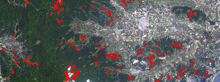
13 Development of Landslide Recognition Tool Landslide Recognition Tool Collapse pattern of collapse-type landslide have seen in similar pattern. Applying template matching (face recognition) technique to recognize collapse-type landslide area. Modification of Landslide Recognition Tool Water and cloud region mask function by blue and NIR channel Blue>threshold as cloud NIR<threshold as water Urban area mask function for process time acceleration using NDVI image Calculate averaged NDVI Classify urban area and forest area Utilization of optimized template for process time acceleration To detect landslide collapse point in multi direction To reduce number of template (from 8 to 1)
14 Image of Processing Band1 Band2 Make mask image (water & cloud area) Band3 Band4 Resize to smal size image Input AVNIR-2 images Original algorithm Modified algorithm Make mask image (urban & forest area) RGB RGB Template Matching (Landslide Recognition) Template Matching (Landslide Recognition)

15 Result with unmasked processing JAXA JAXA

16 Effect of water area mask NIR < 50 as water, Blue > 170 as cloud JAXA JAXA


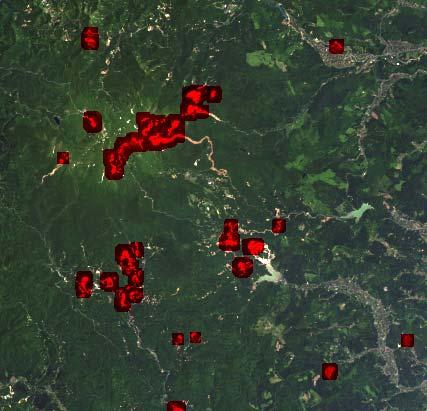
17 Effect of urban area mask JAXA JAXA
18 Conclusions Result of DInSAR of Zentoku Landslide Definitive displacement can t confirm in result of Comparison result of ascending and descending was similar. Reactivated landslide in Kochi Pref., Japan was detected. Modification of Landslide Recognition Tool Applied mask functions (cloud, water, and urban) can be reduce a time for processing was confirmed. Modified algorithm and optimized template recognized landslide collapse points appropriately. Some errors still remained. Making more optimized template.
19
20 Dx Relationship of differential phase and slope angle differential phase Offnadir angle of acsending dφ=(4π/λ)*(dh/cos(θ i )) dφ: differential phase λ: wave length dh: surface deformation θ i : local incidence angle Offnadir angle of decsending Phase (cycle) A34.3 D34.3 slope angle (deg.) Relationship of differential phase and slope angle Dy Dy Dx Analysis condition: λ=23.8cm, 5cm subsidence Data acquired from ascending orbit is effective to detect surface deformation of east slope than descending orbit.
Haiti Earthquake (12-Jan-2010) co-seismic motion using ALOS PALSAR
 co-seismic motion using ALOS PALSAR") Haiti Earthquake (12-Jan-2010) co-seismic motion using ALOS PALSAR Urs Wegmüller, Charles Werner, Maurizio Santoro Gamma Remote Sensing, CH-3073 Gümligen, Switzerland SAR data: JAXA, METI; PALSAR AO Project
Haiti Earthquake (12-Jan-2010) co-seismic motion using ALOS PALSAR Urs Wegmüller, Charles Werner, Maurizio Santoro Gamma Remote Sensing, CH-3073 Gümligen, Switzerland SAR data: JAXA, METI; PALSAR AO Project
Detecting Illegal Mining Activities Using DInSAR
 Detecting Illegal Mining Activities Using DInSAR H.S. Kutoglu 1, H. Akcin 1, T. Deguchi 2, H. Kemaldere 1 1 Zonguldak Karaelmas Universitesi,, Türkiye; T 2 ERSDAC, Japan 17.06.2008 TS4D_3031 Study Area
Burst overlapping of ALOS-2 PALSAR-2 ScanSAR-ScanSAR interferometry
 Burst overlapping of ALOS-2 PALSAR-2 ScanSAR-ScanSAR interferometry Japan Aerospace Exploration Agency Earth Observation Research Center Ryo Natsuaki, Takeshi Motohka, Shinichi Suzuki and Masanobu Shimada
Surface Deformation Measurements Scientific Requirements & Challenges
 Surface Deformation Measurements Scientific Requirements & Challenges 1st Science and Application Workshop for Germany-Japan Next-Generation SAR M. Eineder, C. Minet, A. Parizzi Tokyo, 27.6.2013 Tandem-L
In order to obtain a long term monitoring result for the Kilauea Volcano, ALOS PALSAR images taken on Track 287, Frame 38, ascending orbit with 21.5 d
 ALOS PALSAR OBSERVATION OF KILAUEA VOLCANO ACTIVITIES FROM 2006 TO 2009 Zhe Hu, Linlin Ge, Xiaojing Li, Kui Zhang, Alex Hay-Man NG and Chris Rizos Cooperative Research Centre for Spatial Information &
ALOS DATA for Industrial Applications
 ALOS DATA for Industrial Applications Geographical observation of the landslide of the roadside slope and its background hill and its prediction measure Toshiro Fukuyama Fukuyama Consultants Co., Ltd.
The Potential of High Resolution Satellite Interferometry for Monitoring Enhanced Oil Recovery
 The Potential of High Resolution Satellite Interferometry for Monitoring Enhanced Oil Recovery Urs Wegmüller a Lutz Petrat b Karsten Zimmermann c Issa al Quseimi d 1 Introduction Over the last years land
Landslide Monitoring in Three Gorges Area By Joint Use of Phase Based and Amplitude Based Methods
 Landslide Monitoring in Three Gorges Area By Joint Use of Phase Based and Amplitude Based Methods Xuguo Shi, Lu Zhang, Mingsheng Liao, Timo Balz LIESMARS, Wuhan University Outlines Introduction InSAR Results
ALOS PI Symposium 2009, 9-13 Nov 2009 Hawaii MOTION MONITORING FOR ETNA USING ALOS PALSAR TIME SERIES
 ALOS PI Symposium 2009, 9-13 Nov 2009 Hawaii ALOS Data Nodes: ALOS RA-094 and RA-175 (JAXA) MOTION MONITORING FOR ETNA USING ALOS PALSAR TIME SERIES Urs Wegmüller, Charles Werner and Maurizio Santoro Gamma
Interferometric SAR analysis for Characterizing Surface Changes of an Active Volcano using Open Source Software
 Interferometric SAR analysis for Characterizing Surface Changes of an Active Volcano using Open Source Software Asep SAEPULOH1, Katsuaki KOIKE1, Makoto OMURA2 1 Department of Life and Environmental Sciences,
The Tohoku Earthquake 2011 Case.
 Wide Area Deformation map generation with TerraSAR-X Data. The Tohoku Earthquake 2011 Case. N. Yague-Martinez (1), C. Minet (2), M. Eineder (2), B. Schättler (2) (1) Starlab, Spain (2) Remote Sensing Technology
Current Status of the ALOS-2 Operation and PALSAR-2 Calibration Activities
 Current Status of the ALOS-2 Operation and PALSAR-2 Calibration Activities Takeshi Motohka, Ryo Natsuaki, Yukihiro Kankaku, Shinichi Suzuki, Masanobu Shimada (JAXA) Osamu Isoguchi (RESTEC) CEOS SAR CALVAL
EXTRACTION OF FLOODED AREAS DUE THE 2015 KANTO-TOHOKU HEAVY RAINFALL IN JAPAN USING PALSAR-2 IMAGES
 EXTRACTION OF FLOODED AREAS DUE THE 2015 KANTO-TOHOKU HEAVY RAINFALL IN JAPAN USING PALSAR-2 IMAGES F. Yamazaki a, *, W. Liu a a Chiba University, Graduate School of Engineering, Chiba 263-8522, Japan
Introduction of PALSAR and PALSAR Data Application Plan
 Introduction of PALSAR and PALSAR Data Application Plan September 19 th, 2006 Tomonori Deguchi deguchi@ersdac.or.jp Earth Remote Sensing Data Analysis Center (ERSDAC) http://www.ersdac.or.jp Contents 1.
Related missions and programs for Snowfall and Snow Hydrology of JAXA
 Related missions and programs for Snowfall and Snow Hydrology of JAXA ALOS AVNIR-2 2006/11/05 Shuji Shimizu Japan Aerospace Exploration Agency (JAXA) Earth Observation Research Center (EORC) JAXA Earth
Detecting an area affected by forest fires using ALOS PALSAR
 Detecting an area affected by forest fires using ALOS PALSAR Keiko Ishii (1), Masanobu Shimada (2), Osamu Isoguchi (2), Kazuo Isono (1) (1)Remote Sensing Technology Center of Japan (2)Japan Aerospace Exploration
Dr. Simon Plank. German Remote Sensing Data Center (DFD), German Aerospace Center (DLR)
, German Aerospace Center (DLR)") Pre-survey suitability analysis of the differential and persistent scatterer synthetic ti aperture radar interferometry t method for deformation monitoring of landslides Dr. Simon Plank German Remote Sensing
Pre-survey suitability analysis of the differential and persistent scatterer synthetic ti aperture radar interferometry t method for deformation monitoring of landslides Dr. Simon Plank German Remote Sensing
3-Dimension Deformation Mapping from InSAR & Multiaperture. Hyung-Sup Jung The Univ. of Seoul, Korea Zhong Lu U.S. Geological Survey, U.S.A.
 3-Dimension Deformation Mapping from InSAR & Multiaperture InSAR Hyung-Sup Jung The Univ. of Seoul, Korea Zhong Lu U.S. Geological Survey, U.S.A. Outline Introduction to multiple-aperture InSAR (MAI) 3-D
Teruyuki Nakajima Director, Earth Observation Research Center (EORC) Japan Aerospace Exploration Agency (JAXA)
 Japan Aerospace Exploration Agency (JAXA)") Tokyo Inter. Conference on the Forest Governance Initiative - Improving Forest Governance using Forest Early Warning Systems and Satellite Technologies - October 24-26, 2017 Teruyuki Nakajima Director,
Tokyo Inter. Conference on the Forest Governance Initiative - Improving Forest Governance using Forest Early Warning Systems and Satellite Technologies - October 24-26, 2017 Teruyuki Nakajima Director,
Application of satellite InSAR data for hydrocarbon reservoir monitoring
 Application of satellite InSAR data for hydrocarbon reservoir monitoring A. Tamburini, A. Belson, A. Ferretti, F. Novali TRE Milano, Italy Copyright - Tele-Rilevamento Europa - 2004 Outline SqueeSAR TM
DIFFERENTIAL INSAR STUDIES IN THE BOREAL FOREST ZONE IN FINLAND
 DIFFERENTIAL INSAR STUDIES IN THE BOREAL FOREST ZONE IN FINLAND Kirsi Karila (1,2), Mika Karjalainen (1), Juha Hyyppä (1) (1) Finnish Geodetic Institute, P.O. Box 15, FIN-02431 Masala, Finland, Email:
ALOS-2 Basic Observation Scenario (First Edition) January 10, 2014 JAXA/ALOS-2 Project
 January 10, 2014 JAXA/ALOS-2 Project") ALOS-2 Basic Observation Scenario (First Edition) January 10, 2014 JAXA/ALOS-2 Project 1 1.First edition 2.Purpose and Background 3.Approach of the Basic Observation Scenario 4.Basic Observation
ALOS-2 Basic Observation Scenario (First Edition) January 10, 2014 JAXA/ALOS-2 Project 1 1.First edition 2.Purpose and Background 3.Approach of the Basic Observation Scenario 4.Basic Observation
JAXA agency report. Masumi MATSUNAGA Satellite Applications and Operations Center(SAOC), JAXA
, JAXA") JAXA agency report Masumi MATSUNAGA Satellite Applications and Operations Center(SAOC), JAXA JAXA Activities Space Transportation Human Space Activities Satellite Programs Lunar & Planetary Exploration
JAXA agency report Masumi MATSUNAGA Satellite Applications and Operations Center(SAOC), JAXA JAXA Activities Space Transportation Human Space Activities Satellite Programs Lunar & Planetary Exploration
ALOS-2 Basic Observation Scenario (3rd Edition Ver. A) August 15, 2018 JAXA/ALOS-2 Project
 August 15, 2018 JAXA/ALOS-2 Project") ALOS-2 Basic Observation Scenario (3rd Edition Ver. A) August 15, 2018 JAXA/ALOS-2 Project 1 Details of revision Version Date Page Details of revision A 2018/8/15 P4, 8, 14 Changed the observation mode
ALOS-2 Basic Observation Scenario (3rd Edition Ver. A) August 15, 2018 JAXA/ALOS-2 Project 1 Details of revision Version Date Page Details of revision A 2018/8/15 P4, 8, 14 Changed the observation mode
The March 11, 2011, Tohoku-oki earthquake (Japan): surface displacement and source modelling
: surface displacement and source modelling") The March 11, 2011, Tohoku-oki earthquake (Japan): surface displacement and source modelling Salvatore Stramondo Bignami C., Borgstrom S., Chini M., Guglielmino F., Melini D., Puglisi G., Siniscalchi V.,
The March 11, 2011, Tohoku-oki earthquake (Japan): surface displacement and source modelling Salvatore Stramondo Bignami C., Borgstrom S., Chini M., Guglielmino F., Melini D., Puglisi G., Siniscalchi V.,
TEMPORAL VARIABILITY OF ICE FLOW ON HOFSJÖKULL, ICELAND, OBSERVED BY ERS SAR INTERFEROMETRY
 TEMPORAL VARIABILITY OF ICE FLOW ON HOFSJÖKULL, ICELAND, OBSERVED BY ERS SAR INTERFEROMETRY Florian Müller (1), Helmut Rott (2) (1) ENVEO IT, Environmental Earth Observation GmbH, Technikerstrasse 21a,
New Era of Global Monitoring by ALOS-2: Advanced Land Observing Satellite-2 DAICHI-2 Yuko Suzuki
 New Era of Global Monitoring by ALOS-2: Advanced Land Observing Satellite-2 DAICHI-2 Yuko Suzuki International Relations and Research Department Japan Aerospace Exploration Agency (JAXA) 1 Dawning Era
Fault model of the 2007 Noto Hanto earthquake estimated from PALSAR radar interferometry and GPS data
 LETTER Earth Planets Space, 60, 99 104, 2008 Fault model of the 2007 Noto Hanto earthquake estimated from PALSAR radar interferometry and GPS data Yo Fukushima 1, Taku Ozawa 2, and Manabu Hashimoto 1 1
AlOS-PALSAR data for Landslide Monitoring and Geological Mapping
 AlOS-PALSAR data for Landslide Monitoring and Geological Mapping Vern Singhroy, P-J Alasset, G Pavlic Canada Centre for Remote Sensing Ottawa, Canada vern.singhroy@ccrs.nrcan.gc.ca Objectives InSAR monitoring
GPS and GIS Assisted Radar Interferometry
 GPS and GIS Assisted Radar Interferometry Linlin Ge, Xiaojing Li, Chris Rizos, and Makoto Omura Abstract Error in radar satellite orbit determination is a common problem in radar interferometry (INSAR).
DAMAGE DETECTION OF THE 2008 SICHUAN, CHINA EARTHQUAKE FROM ALOS OPTICAL IMAGES
 DAMAGE DETECTION OF THE 2008 SICHUAN, CHINA EARTHQUAKE FROM ALOS OPTICAL IMAGES Wen Liu, Fumio Yamazaki Department of Urban Environment Systems, Graduate School of Engineering, Chiba University, 1-33,
Damage Detection of the 2008 Sichuan, China, Earthquake using
 Damage Detection of the 2008 Sichuan, China, Earthquake using ALOS/AVNIR-2 Images 2008.6.10 Wen Liu and Fumio Yamazaki Department of Urban Environment Systems, Chiba University 1 Content Overview of China
ALOS-2 Basic Observation Scenario (First Edition) October 10, 2014 JAXA/ALOS-2 Project
 October 10, 2014 JAXA/ALOS-2 Project") ALOS-2 Basic Observation Scenario (First Edition) October 10, 2014 JAXA/ALOS-2 Project 1 Revision details Rev. Date Page Revision details A October 10, 2014 P13,P30 P17 Updated the date of Basic Observation
ALOS-2 Basic Observation Scenario (First Edition) October 10, 2014 JAXA/ALOS-2 Project 1 Revision details Rev. Date Page Revision details A October 10, 2014 P13,P30 P17 Updated the date of Basic Observation
Case Study of Japan: Crustal deformation monitoring with GNSS and InSAR
 Technical Seminar Reference Frame in Practice, Case Study of Japan: Crustal deformation monitoring with GNSS and InSAR Basara Miyahara miyahara-b96ip@milt.go.jp Geospatial Information Authority of Japan
EORC's Science and Applications Research Project using ALOS Data
 EORC's Science and Applications Research Project using ALOS Data 27 March 2001 Symposium for ALOS Data Application Users Kogakuin University, Shinjuku, Tokyo Tamotsu Igarashi NASDA/EORC 1.1 ALOS Science
Real Time Subsidence Monitoring Techniques in Undercity Mining and a Case Study: Zonguldak Undercity Applications-Turkey
 Real Time Subsidence Monitoring Techniques in Undercity Mining and a Case Study: Zonguldak Undercity Hakan AKCIN, Hakan S. KUTOGLU, Turkey Keywords: Undercity mining, subsidence, PALSAR, RADARSAT, GNSS.
Impact of the Envisat Mission Extension on SAR data
 Impact of the Envisat Mission Extension on SAR data Impact of Envisat extension on SAR data Prepared by nuno miranda Reference Issue 0.9 Revision Date of Issue 23 August 2010 Status Preliminary version
NASA Jet Propulsion Laboratory Data Products
 NASA Jet Propulsion Laboratory Data Products 17 April 2014 Emergency Response Spatial Tools Technical Interchange Maggi Glasscoe Margaret.T.Glasscoe@jpl.nasa.gov Sang-Ho Yun Sang-Ho.Yun@jpl.nasa.gov www.nasa.gov
 13.4% 43.4% 1.2% 2.8% 47 46, 389 = 47 47 7 3 450, 636 47 47 68 3 185, 556 = 47 47 7 4 3 21, 349 21, 045 25, 349 34% 31% 38% = 47 47 8 3 13 = 47 47 32 13 i, j = 1,..., n C j = S s=1 C β j,s j,s β j,s
Status of GCOM and expectation for microwave scatterometer
 Status of GCOM and expectation for microwave scatterometer Keiji Imaoka 1, Misako Kachi 1, Tamotsu Igarashi 1, Keizo Nakagawa 1, Naoto Ebuchi 2, Taikan Oki 1,3, and Haruhisa Shimoda 1,4 1 Japan Aerospace
INTRODUCTION OF A SUCCESS STORY IN THE PHILIPPINES
 INTRODUCTION OF A SUCCESS STORY IN THE PHILIPPINES Arturo S. Daag Department of Science and Technology Philippine Institute of Volcanology and Seismology (DOST-PHIVOLCS) Establishment of Sentinel Asia
Earthquake and Volcano Service
 Ref. Ares(2014)73773-15/01/2014 Earthquake and Volcano Service WP Leader: Istituto Nazionale di Geofisica e Vulcanologia (Italy) Contributors: NILU (Norway), EUCENTRE (Italy), GAMMA (Switzerland), IGAR
Impact of the Envisat Mission Extension on SAR data
 Impact of the Envisat Mission Extension on SAR data Impact of Envisat Mission Extension on SAR data - 1.0 Prepared by Nuno Miranda, Berthyl Duesmann, Monserrat Pinol, Davide Giudici, Davide D Aria Reference
Available online at GHGT-9. Detection of surface deformation related with CO 2 injection by DInSAR at In Salah, Algeria
 Available online at www.sciencedirect.com Energy Procedia 100 (2009) (2008) 2177 2184 000 000 Energy Procedia www.elsevier.com/locate/procedia www.elsevier.com/locate/xxx GHGT-9 Detection of surface deformation
Early Warning and Earthquake Monitoring Using New Earth Observation Radar Techniques
 Early Warning and Earthquake Monitoring Using New Earth Observation Radar Techniques APSCO Third International Symposium on Earth Quake Monitoring and Early Warning by Using Space Technology Beijing, China
DISASTER DAMAGE DETECTION AND ITS RECOVERY SUPPORT SYSTEM OF ROAD AND RAILROAD USING SATELLITE IMAGES
 International Archives of the Photogrammetry, Remote Sensing and Spatial Information Science, Volume XXXVIII, Part 8, Kyoto Japan 2010 DISASTER DAMAGE DETECTION AND ITS RECOVERY SUPPORT SYSTEM OF ROAD
JAXA s Contributions to the Climate Change Monitoring
 0 JAXA s Contributions to the Climate Change Monitoring June 7, 2011 Takao Akutsu Planning Manager Japan Aerospace Exploration Agency (JAXA) Japanese Main Activities of Earth Observation 1 GEOSS 10 years
RADAR Remote Sensing Application Examples
 RADAR Remote Sensing Application Examples! All-weather capability: Microwave penetrates clouds! Construction of short-interval time series through cloud cover - crop-growth cycle! Roughness - Land cover,
Luyi Sun & Jan-Peter Muller, Imaging Group, Mullard Space Science Laboratory, University College London
 Evaluation of the use of the sub-pixel Offset Tracking method with conventional dinsar techniques to monitor landslides in densely vegetated terrain in the Three Gorges Region, China Luyi Sun & Jan-Peter
Field Survey of Non-tectonic Surface Displacements Caused by the 2016 Kumamoto Earthquake Around Aso Valley
 Field Survey of Non-tectonic Surface Displacements Caused by the 2016 Kumamoto Earthquake Around Aso Valley 47 Field Survey of Non-tectonic Surface Displacements Caused by the 2016 Kumamoto Earthquake
Spatial Planning Platform Meeting
 Spatial Planning Platform Meeting August 1 st 2018 Part II Session 1 Design and Implementation of National and Regional Planning for Inclusive Growth Spatial info from space based technologies RESTEC (Remote
Spatial Web Technology for Urban Green Society (A Case of Tsukuba City)
") The 5th Japan-Korea-China Joint Conference on Geography (Green Society in East Asia: A Geographical Contribution) Spatial Web Technology for Urban Green Society (A Case of Tsukuba City) Ko Ko Lwin and
The 5th Japan-Korea-China Joint Conference on Geography (Green Society in East Asia: A Geographical Contribution) Spatial Web Technology for Urban Green Society (A Case of Tsukuba City) Ko Ko Lwin and
Contribution of Sentinel Asia Activities to Disaster Management in Asia Pacific Region: Sentinel Asia Success Story in the Philippines Project
 Contribution of Sentinel Asia Activities to Disaster Management in Asia Pacific Region: Sentinel Asia Success Story in the Philippines Project Arturo Daag PHIVOLCS, PHILIPPINES 13 October 2015 Bangkok
Case study of Japan: Reference Frames in Practice
 Case study of Japan: Reference Frames in Practice Basara Miyahara and Koji Matsuo Sponsors: 1 Outline Introduction - Geodetic reference frame of Japan - GEONET : continuous GNSS observation system Geometric
MONITORING BAWAKARAENG POST-LANDSLIDE USING ALOS PALSAR DINSAR AND GROUND MEASUREMENT
 MONITORING BAWAKARAENG POST-LANDSLIDE USING ALOS PALSAR DINSAR AND GROUND MEASUREMENT Ilham Alimuddin 1,2, Luhur Bayuaji 2, Josaphat Tetuko Sri Sumantyo 2 and Hiroaki Kuze 2 1,2 Department of Geology,
THE FIRST EXPERIENCE OF USING ALOS DATA FOR DISASTER MONITORING
 THE FIRST EXPERIENCE OF USING ALOS DATA FOR DISASTER MONITORING Dr. Nguyen Dinh Duong, IG, VAST Dr. Nguyen Xuan Lam, RSC, MONRE Dr. Hoang Minh Hien,, DMU, MARD Contents The Xangsane Typhoon Acquisition
Characterization of Landslide Deformations in Three Gorges Area Using Multiple InSAR Data Stacks
 Remote Sens. 2013, 5, 2704-2719; doi:10.3390/rs5062704 Article OPEN ACCESS Remote Sensing ISSN 2072-4292 www.mdpi.com/journal/remotesensing Characterization of Landslide Deformations in Three Gorges Area
The financial and communal impact of a catastrophe instantiated by. volcanoes endlessly impact on lives and damage expensive infrastructure every
 Chapter 1 Introduction The financial and communal impact of a catastrophe instantiated by geophysical activity is significant. Landslides, subsidence, earthquakes and volcanoes endlessly impact on lives
COAL MINE LAND SUBSIDENCE MONITORING BY USING SPACEBORNE INSAR DATA-A CASE STUDY IN FENGFENG, HEBEI PROVINCE, CHINA
 COAL MINE LAND SUBSIDENCE MONITORING BY USING SPACEBORNE INSAR DATA-A CASE STUDY IN FENGFENG, HEBEI PROVINCE, CHINA Li Cao a, Yuehua Zhang a, Jianguo He a, Guang Liu b,huanyin Yue b, Runfeng Wang a, Linlin
Full Polarimetric Synthetic Aperture Radar (SAR) Data for Ionosphere Observation - A Comparative Study
 Data for Ionosphere Observation - A Comparative Study") Full Polarimetric Synthetic Aperture Radar (SAR) Data for Ionosphere Observation - A Comparative Study Shradha Mohanty 1 *, Gulab Singh 1 1 CSRE, IIT Bombay *Visiting Researcher at ISR, Boston College
Full Polarimetric Synthetic Aperture Radar (SAR) Data for Ionosphere Observation - A Comparative Study Shradha Mohanty 1 *, Gulab Singh 1 1 CSRE, IIT Bombay *Visiting Researcher at ISR, Boston College
Radar Remote Sensing: Monitoring Ground Deformations and Geohazards from Space
 Radar Remote Sensing: Monitoring Ground Deformations and Geohazards from Space Xiaoli Ding Department of Land Surveying and Geo-Informatics The Hong Kong Polytechnic University A Question 100 km 100 km
Sentinel Asia Tsunami Working Group
 Sentinel Asia Tsunami Working Group Co-Chairman: Prof. Shunichi Koshimura Abdul Muhari, PhD 4 th Joint Project Team Meeting (JPTM 2017): Sentinel Asia STEP 3 Abdul MUHARI, PhD Ministry of Marine Affairs
Improved PSI Performance for Landslide Monitoring Applications. J. Duro, R. Iglesias, P. Blanco-Sánchez, F. Sánchez and D. Albiol
 Improved PSI Performance for Landslide Monitoring Applications J. Duro, R. Iglesias, P. Blanco-Sánchez, F. Sánchez and D. Albiol Outline Area of Study Previous PSI (and others) studies Main conclusions
Effect of Unmodelled Reference Frame Motion on InSAR Deformation Estimates
 Effect of Unmodelled Reference Frame Motion on InSAR Deformation Estimates Hermann Bähr 1, Sami Samiei-Esfahany 2 and Ramon Hanssen 2 1 Karlsruhe Institute of Technology, Germany 2 Delft University of
K&C Phase 4 Status report. Use of short-period ALOS-2 observations for vegetation characterization and classification
 K&C Phase 4 Status report Use of short-period ALOS-2 observations for vegetation characterization and classification Paul Siqueira University of Massachusetts, Amherst Science Team meeting #22 Tokyo, Japan,
IEEE JOURNAL OF SELECTED TOPICS IN APPLIED EARTH OBSERVATIONS AND REMOTE SENSING 1. Mokhamad Yusup Nur Khakim, Takeshi Tsuji, and Toshifumi Matsuoka
 IEEE JOURNAL OF SELECTED TOPICS IN APPLIED EARTH OBSERVATIONS AND REMOTE SENSING 1 Detection of Localized Surface Uplift by Differential SAR Interferometry at the Hangingstone Oil Sand Field, Alberta,
Ground deformation in Thessaly, Central Greece, between 1992 and 2000 by means of ERS multi-temporal InSAR
 INGV Ground deformation in Thessaly, Central Greece, between 1992 and 2000 by means of ERS multi-temporal InSAR S. Atzori (1), C. Tolomei (1), S. Salvi (1), A. Ganas (2), S. Stramondo (1) and L. Colini
CHAPTER-7 INTERFEROMETRIC ANALYSIS OF SPACEBORNE ENVISAT-ASAR DATA FOR VEGETATION CLASSIFICATION
 147 CHAPTER-7 INTERFEROMETRIC ANALYSIS OF SPACEBORNE ENVISAT-ASAR DATA FOR VEGETATION CLASSIFICATION 7.1 INTRODUCTION: Interferometric synthetic aperture radar (InSAR) is a rapidly evolving SAR remote
Sentinel Asia System Operation for Disaster Management in Sri Lanka Major General L.B.R. Mark (Retd) Director General Disaster Management Centre
 Director General Disaster Management Centre") Sentinel Asia System Operation for Disaster Management in Sri Lanka Major General L.B.R. Mark (Retd) Director General Disaster Management Centre Government of Sri Lanka OUTLINE Background Disasters in
Sentinel Asia System Operation for Disaster Management in Sri Lanka Major General L.B.R. Mark (Retd) Director General Disaster Management Centre Government of Sri Lanka OUTLINE Background Disasters in
Continuous Caldera Changes in Miyakejima Volcano after Hiroyuki HASEGAWA, Hiroshi P. SATO and Junko IWAHASHI
 Continuous Caldera Changes in Miyakejima Volcano after 2001 60 Hiroyuki HASEGAWA, Hiroshi P. SATO and Junko IWAHASHI Abstract This study investigated the evolvement of the caldera at Miyakejima volcano
Application of advanced InSAR techniques for the measurement of vertical and horizontal ground motion in longwall minings
 University of Wollongong Research Online Coal Operators' Conference Faculty of Engineering and Information Sciences 2013 Application of advanced InSAR techniques for the measurement of vertical and horizontal
SLOPE STABILITY MONITORING USING SPACE-BORNE REPEAT- PASS SAR INTERFEROMETRY
 SLOPE STABILITY MONITORING USING SPACE-BORNE REPEAT- PASS SAR INTERFEROMETRY Urs WEGMÜLLER 1, Charles WERNER 1, Tazio STROZZI 1, Andreas WIESMANN 1, and Hugo RAETZO 2 1 Gamma Remote Sensing AG, Switzerland
SURFACE DEFORMATION OF ALPINE TERRAIN DERIVED BY PS-INSAR TECHNIQUE ON THE SIACHEN GLACIER
 SURFACE DEFORMATION OF ALPINE TERRAIN DERIVED BY PS-INSAR TECHNIQUE ON THE SIACHEN GLACIER Junchao Shi and Ling Chang Department of Remote Sensing, Delft University of Technology, the Netherlands. ABSTRACT
22 Bulletin of the Geospatial Information Authority of Japan, Vol.59 December, 2011 Fig. 1 Crustal deformation (horizontal) associated with the 2011 o
 associated with the 2011 o") The Crustal Deformation and Fault Model of the 2011 off the Pacific Coast of Tohoku Earthquake 21 The Crustal Deformation and Fault Model of the 2011 off the Pacific Coast of Tohoku Earthquake Tetsuro
The Crustal Deformation and Fault Model of the 2011 off the Pacific Coast of Tohoku Earthquake 21 The Crustal Deformation and Fault Model of the 2011 off the Pacific Coast of Tohoku Earthquake Tetsuro
Retrieving 3D deformation pattern of a landslide with hiresolution InSAR and in-situ measurements: Just landslide case-study
 Retrieving 3D deformation pattern of a landslide with hiresolution InSAR and in-situ measurements: Just landslide case-study Zbigniew Perski (1), Petar Marinković (2), Yngvar Larsen (3), Tomasz Wojciechowski
Research Article Monitoring of Ground Deformation due to Excessive Withdrawal of Natural Gas Using SBAS
 Mathematical Problems in Engineering, Article ID 67451, 6 pages http://dx.doi.org/1.1155/214/67451 Research Article Monitoring of Ground Deformation due to Excessive Withdrawal of Natural Gas Using SBAS
Satellite Remote Sensing for Ocean
 Satellite Remote Sensing for Ocean August 17, 2017 Masatoshi Kamei RESTEC All rights reserved RESTEC 2015 Contents 1. About RESTEC and Remote Sensing 2. Example of Remote Sensing Technology 3. Remote Sensing
Multi-temporal archaeological and environmental prospection in Nasca (Peru) with ERS-1/2, ENVISAT and Sentinel-1A C-band SAR data
 with ERS-1/2, ENVISAT and Sentinel-1A C-band SAR data") 12-13 November 215 ESA-ESRIN, Frascati (Rome), Italy Day 1 Session: Historical Landscapes and Environmental Analysis Multi-temporal archaeological and environmental prospection in Nasca (Peru) with ERS-1/2,
12-13 November 215 ESA-ESRIN, Frascati (Rome), Italy Day 1 Session: Historical Landscapes and Environmental Analysis Multi-temporal archaeological and environmental prospection in Nasca (Peru) with ERS-1/2,
The Removal of Lava Flow Subsidence Signals from deformation interferograms at Nyamuragira Volcano, D.R. Congo
 The Removal of Lava Flow Subsidence Signals from deformation interferograms at Nyamuragira Volcano, D.R. Congo Andy Toombs & Geoff Wadge Environmental Systems Science Centre National Centre for Earth Observation
J. Manuel Delgado (1,2), Roberto Cuccu (1), Giancarlo Rivolta (1)
, Roberto Cuccu (1), Giancarlo Rivolta (1)") MONITORING GROUND DEFORMATION USING PERSISTENT SCATTERS INTERFEROMETRY (PSI) AND SMALL BASELINES (SBAS) TECHNIQUES INTEGRATED IN THE ESA RSS SERVICE: THE CASE STUDY OF VALENCIA, ROME AND SOUTH SARDINIA
MONITORING GROUND DEFORMATION USING PERSISTENT SCATTERS INTERFEROMETRY (PSI) AND SMALL BASELINES (SBAS) TECHNIQUES INTEGRATED IN THE ESA RSS SERVICE: THE CASE STUDY OF VALENCIA, ROME AND SOUTH SARDINIA
Deformation measurement using SAR interferometry: quantitative aspects
 Deformation measurement using SAR interferometry: quantitative aspects Michele Crosetto (1), Erlinda Biescas (1), Ismael Fernández (1), Ivan Torrobella (1), Bruno Crippa (2) (1) (2) Institute of Geomatics,
Model based forest height estimation with ALOS/PalSAR: A first study.
 Model based forest height estimation with ALOS/PalSAR: A first study. K.P. Papathanassiou*, I. Hajnsek*, T.Mette*, S.R. Cloude** and A. Moreira* * (DLR) (DLR-HR) Oberpfaffenhofen, Germany ** AEL Consultants
EFFECT OF ANCILLARY DATA ON THE PERFORMANCE OF LAND COVER CLASSIFICATION USING A NEURAL NETWORK MODEL. Duong Dang KHOI.
 EFFECT OF ANCILLARY DATA ON THE PERFORMANCE OF LAND COVER CLASSIFICATION USING A NEURAL NETWORK MODEL Duong Dang KHOI 1 10 Feb, 2011 Presentation contents 1. Introduction 2. Methods 3. Results 4. Discussion
Investigating landslides with space-borne Synthetic Aperture Radar (SAR) interferometry
 interferometry") Engineering Geology 88 (2006) 173 199 www.elsevier.com/locate/enggeo Investigating landslides with space-borne Synthetic Aperture Radar (SAR) interferometry Carlo Colesanti 1, Janusz Wasowski a, a CNR-IRPI,
Engineering Geology 88 (2006) 173 199 www.elsevier.com/locate/enggeo Investigating landslides with space-borne Synthetic Aperture Radar (SAR) interferometry Carlo Colesanti 1, Janusz Wasowski a, a CNR-IRPI,
ScanSAR Interferometry with PALSAR
 ScanSAR Interferometry with PALSAR Authors: David Sandwell, Rob Mellors, and Xiaopeng Tong Funding: NASA EarthScope Program - InSAR and Geodetic Imaging Component Data: ALOS PALSAR - JAXA EORC and ASF
DETECTING ICE MOTION IN GROVE MOUNTAINS, EAST ANTARCTICA WITH ALOS/PALSAR AND ENVISAT/ASAR DATA
 DETECTING ICE MOTION IN GROVE MOUNTAINS, EAST ANTARCTICA WITH ALOS/PALSAR AND ENVISAT/ASAR DATA TIAN Xin (1), LIAO Mingsheng (1), ZHOU Chunxia (2), ZHOU Yu (3) (1) State Key Laboratory of Information Engineering
InSAR-derived Crustal Deformation and Reverse Fault Motion of the 2017 Iran-Iraq Earthquake in the Northwestern Part of the Zagros Orogenic Belt
 InSAR-derived Crustal Deformation and Reverse Fault Motion of the 2017 Iran-Iraq Earthquake in the Northwestern Part of the Zagros Orogenic Belt Tomokazu Kobayashi, Yu Morishita, Hiroshi Yarai and Satoshi
VALIDATION OF THE PERMANENT SCATTERERS TECHNIQUE IN URBAN AREAS
 VALIDATION OF THE PERMANENT SCATTERERS TECHNIQUE IN URBAN AREAS Alessandro Ferretti, Claudio Prati, Fabio Rocca, Carlo Colesanti Dipartimento di Elettonica e Informazione Politecnico di Milano Piazza L.
APPEARANCE OF PERSISTENT SCATTERERS FOR DIFFERENT TERRASAR-X ACQUISITION MODES
 APPEARANCE OF PERSISTENT SCATTERERS FOR DIFFERENT TERRASAR-X ACQUISITION MODES Stefan Gernhardt a, Nico Adam b, Stefan Hinz c, Richard Bamler a,b a Remote Sensing Technology, TU München, Germany b Remote
STANDWISE CHANGE DETECTION FOR GROWING STOCK USING REPEAT-PASS ALOS PALSAR / PALSAR-2 DATA
 STANDWISE CHANGE DETECTION FOR GROWING STOCK USING REPEAT-PASS ALOS PALSAR / PALSAR-2 DATA M. G. Hong a, C. Kim b * a Dept. of Applied Information Technology, Kookmin University, Seoul 02707, Korea hd21351@kookmin.ac.kr
Application of PSI technique to slope stability monitoring in the Daunia mountains, Italy
 ESA ESRIN - Frascati 28 November- 2 December Application of PSI technique to slope stability monitoring in the Daunia mountains, Italy F. Bovenga (1) (fabio.bovenga@ba.infn.it) L. Guerriero (1) R. Nutricato
Supplement of Brief Communication: Rapid mapping of landslide events: the 3 December 2013 Montescaglioso landslide, Italy
 Supplement of Nat. Hazards Earth Syst. Sci., 14, 1835 1841, 2014 http://www.nat-hazards-earth-syst-sci.net/14/1835/2014/ doi:10.5194/nhess-14-1835-2014-supplement Author(s) 2014. CC Attribution 3.0 License.
DETECTION OF CRUSTAL MOVEMENTS IN THE 2011 TOHOKU, JAPAN EARTHQUAKE USING HIGH-RESOLUTION SAR DATA
 Paper No. M-5 DETECTION OF CRUSTAL MOVEMENTS IN THE 2011 TOHOKU, JAPAN EARTHQUAKE USING HIGH-RESOLUTION SAR DATA Fumio Yamazaki 1 and Wen Liu 2 SUMMARY Significant crustal movements were caused by the
Geological Mapping Using EO Data for Onshore O&G Exploration
 Geological Mapping Using EO Data for Onshore O&G Exploration Michael Hall ESA Oil and Gas Workshop, Frascati, Italy michael.hall@infoterra-global.com Why use EO data for Geological Mapping? Availability
GEOMORPHOLOGIC RESEARCH USING LIDAR DATA
 CO-148 GEOMORPHOLOGIC RESEARCH USING LIDAR DATA KOARAI M.(1), OKATANI T.(1), NAKANO T.(1), KOMATSUBARA T.(2), KUROKI T.(3) (1) Geospatical Informaton Authority of Japan, TSUKUBA, IBARAKI, JAPAN ; (2) National
4600 Rickenbacker Cswy, Miami 33149, FL. U.S.A., (2)
") POSTSEISMIC DEFORMATION FOLLOWING THE 2010 HAITI EARTHQUAKE: TIME-DEPENDENT SURFACE SUBSIDENCE INDUCED BY GROUNDWATER FLOW IN RESPONSE TO A SUDDEN UPLIFT Shimon Wdowinski (1), Sang-Hoon Hong (1)(2) (1)
POSTSEISMIC DEFORMATION FOLLOWING THE 2010 HAITI EARTHQUAKE: TIME-DEPENDENT SURFACE SUBSIDENCE INDUCED BY GROUNDWATER FLOW IN RESPONSE TO A SUDDEN UPLIFT Shimon Wdowinski (1), Sang-Hoon Hong (1)(2) (1)
NOTES AND CORRESPONDENCE Segmented Faulting Process of Chelungpu Thrust: Implication of SAR Interferograms
 , Vol. 14, No.2, 241-247, June 2003 NOTES AND CORRESPONDENCE Segmented Faulting Process of Chelungpu Thrust: Implication of SAR Interferograms Chien-Chih Chen 1,*, Chung-Pai Chang 2, and Kun-Shan Chen
Application of Wavelet Spectrum Analysis to Oil Spill Detection by Using Satellite Observation Data
 PAJ Oil Spill Symposium 2008 Application of Wavelet Spectrum Analysis to Oil Spill Detection by Using Satellite Observation Data February 21, 2008 Tokyo, Japan Masanao Hara Dr., VisionTech Inc. 1. Background
where ν and γ are site- and season- specific constants, and P, T and U are modeled as h h h P h = P0 ( *10 ( h h0 )) T h = T0 k( h h0 )
) T h = T0 k( h h0 )") Ground Fissure Monitoring in China Based on PALSAR Data 430 Zhiwei Li (1) Jianjun Zhu (2), Zhengrong Zou (2), Wujiao Dai (2) (1) School of Geosciences & Info-Physics, Central South University, Changsha
Ground Fissure Monitoring in China Based on PALSAR Data 430 Zhiwei Li (1) Jianjun Zhu (2), Zhengrong Zou (2), Wujiao Dai (2) (1) School of Geosciences & Info-Physics, Central South University, Changsha
SUPPLEMENTARY INFORMATION
 SUPPLEMENTARY INFORMATION DOI: 10.1038/NGEO1857 1 Volcanic subsidence triggered by the 2011 Tohoku earthquake in Japan 2 3 Supplementary Information 4 5 6 7 8 9 10 11 12 13 14 15 16 17 18 19 20 21 22 23