The Removal of Lava Flow Subsidence Signals from deformation interferograms at Nyamuragira Volcano, D.R. Congo
|
|
|
- Malcolm Cecil Wilkins
- 5 years ago
- Views:
Transcription


1 The Removal of Lava Flow Subsidence Signals from deformation interferograms at Nyamuragira Volcano, D.R. Congo Andy Toombs & Geoff Wadge Environmental Systems Science Centre National Centre for Earth Observation University of Reading, UK ESA Cat 1 Projects C1P2880 and AOALO.3667

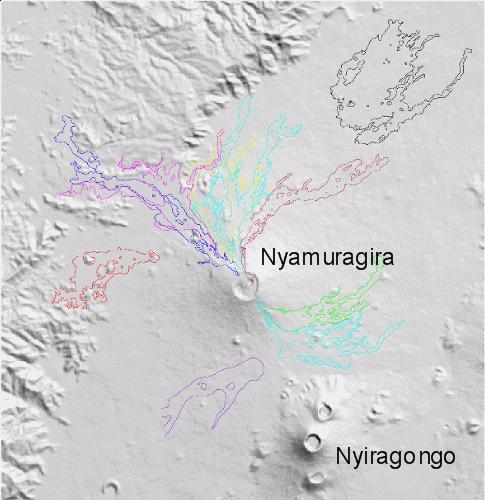
2 Nyamuragira Volcano: Geological Context Nyamuragira is a massive, intra-rift, basaltic shield volcano situated on the western branch of the East African Rift System. It is the most active volcano in Africa having erupted 16 times in the last 33 years.
3 Motivation: Reveal Volcano and Volcano-Tectonic Deformation Signals InSAR data mainly C-Band Coherent surfaces limited to recent lava flows Need to decompose the signals due to: Ground Deformation Atmosphere Noise Lava Flow Subsidence Nyamuragira
4 Eruptions at Nyamuragira: Caldera
5 Eruptions at Nyamuragira:


6 Co-eruptive InSAR deformation due to dykes (cm) Towards satellite Caldera N Flank??? NW Flank N Flank and Caldera SW Flank and Caldera Away from satellite -3-6
7 Eruptions and Data ALOS FBD ALOS FBS Envisat IS7 Envisat IS2 ERS Asc ERS Des JFMAMJJASONDJFMAMJJASONDJFMAMJJASONDJFMAMJJASONDJFMAMJJASOND ALOS FBD ALOS FBS Envisat IS7 Envisat IS2 ERS Asc ERS Des JFMAMJJASONDJFMAMJJASONDJFMAMJJASONDJFMAMJJASONDJFMAMJJASOND ALOS FBD ALOS FBS Envisat IS7 Envisat IS2 ERS Asc ERS Des JFMAMJJASONDJFMAMJJASONDJFMAMJJASONDJFMAMJJASONDJFMAMJJASOND Red bars = Eruptions of Nyamuragira Purple bar = Eruption of Nyiragongo


8 Subsidence Rate is a Function of Time Since Emplacement and Flow Thickness Temporal x x Spatial x x


9 Lava Flow Subsidence Modelling: Coherence 2002 Lava Flow 6 Months after emplacement 18 Months 105 Day coherence images


10 Lava Flow Subsidence Modelling: Method Define lava flow edges and create mask 2002 Flow


11 Lava Flow Subsidence Modelling: Method Initial Quality Control of Data Series Stack of masked displacement images Equivalent Stack of coherence images Quality Control 1. Only use pairs >70 days separation to improve signal to noise Quality Control 2. Apply mean coherence test for the lava flow
12 Lava Flow Subsidence Modelling: Method Take profiles across displacement and coherence data Profiles Downslope Atmospheric phase gradient due to topography Deformation (m) Common Profile Series with a Common Master Increasing Temporal Span Perpendicular profiles Assume flow edges are areas of zero deformation. Normalize profiles. Profile Length (m)
13 Lava Flow Subsidence Modelling: Method Create corrected surfaces for each interferogram by interpolation Original Data Before interpolation: Quality Control 3. Mask profile data more than 2 STD from the mean. Quality Control 4. Mask profile data where coherence < 0.6. Corrected Surface

14 Lava Flow Subsidence Modelling: Method Calculate a regression function for each pixel location on the model surfaces Stack of corrected surfaces Subsidence history given by mean deformation values and interval of each interferogram with time. Now able to remove the phase due to lava subsidence for any interferogram


15 Lava Flow Subsidence Modelling: Results The Lava Flow Field 490 day interferogram Envisat IS2 Mode Dec 2002 Apr 2004 Years day interferogram Envisat IS7 Mode Dec 2006 Jan 2008 Years 14-16


16 Virtue out of necessity: better estimates of lava flow thickness and volume If min = 1.5 m and edge = 3 m then Volume = 6.3 x 10 7 m 3 Otherwise default average = 3 m and Volume= 4.1 x 10 7 m Flow Assume flow thickness proportional to subsidence Scale by assuming minimum thickness and edge (field) thickness Extra volume from ponding and compound overflow
17 Conclusions We have shown that it is possible to map, model and remove the phase attributable to lava flow subsidence. Lava flow subsidence modelling may be a necessary requirement to measure inter-eruption-scale deformation on some volcanoes. We don t yet understand the physical mechanisms of subsidence occurring at a greater rate than thermal contraction alone predicts. We can use subsidence signals to map flow thickness and hence, volume.
Diverse deformation patterns of Aleutian volcanoes from InSAR
 Diverse deformation patterns of Aleutian volcanoes from InSAR Zhong Lu 1, Dan Dzurisin 1, Chuck Wicks 2, and John Power 3 U.S. Geological Survey 1 Cascades Volcano Observatory, Vancouver, Washington 2
Geochemistry, Geophysics, Geosystems. Supporting Information for
 1 2 3 4 5 6 7 8 Geochemistry, Geophysics, Geosystems Supporting Information for Volcano Deformation Survey over the Northern and Central Andes with ALOS InSAR Time Series Anieri M. Morales Rivera 1, Falk
Haiti Earthquake (12-Jan-2010) co-seismic motion using ALOS PALSAR
 co-seismic motion using ALOS PALSAR") Haiti Earthquake (12-Jan-2010) co-seismic motion using ALOS PALSAR Urs Wegmüller, Charles Werner, Maurizio Santoro Gamma Remote Sensing, CH-3073 Gümligen, Switzerland SAR data: JAXA, METI; PALSAR AO Project
Haiti Earthquake (12-Jan-2010) co-seismic motion using ALOS PALSAR Urs Wegmüller, Charles Werner, Maurizio Santoro Gamma Remote Sensing, CH-3073 Gümligen, Switzerland SAR data: JAXA, METI; PALSAR AO Project
MEASURING VOLCANIC DEFORMATION AT UNIMAK ISLAND FROM 2003 TO 2010 USING
 MEASURING VOLCANIC DEFORMATION AT UNIMAK ISLAND FROM 2003 TO 2010 USING WEATHER MODEL-ASSISTED TIME SERIES INSAR Gong, W. a, Meyer, F. J. a, Lee, C. W. b, Lu, Z. c, Freymueller, J a. a. Geophysical Institute,
ALOS PI Symposium 2009, 9-13 Nov 2009 Hawaii MOTION MONITORING FOR ETNA USING ALOS PALSAR TIME SERIES
 ALOS PI Symposium 2009, 9-13 Nov 2009 Hawaii ALOS Data Nodes: ALOS RA-094 and RA-175 (JAXA) MOTION MONITORING FOR ETNA USING ALOS PALSAR TIME SERIES Urs Wegmüller, Charles Werner and Maurizio Santoro Gamma
InSAR measurements of volcanic deformation at Etna forward modelling of atmospheric errors for interferogram correction
 InSAR measurements of volcanic deformation at Etna forward modelling of atmospheric errors for interferogram correction Rachel Holley, Geoff Wadge, Min Zhu Environmental Systems Science Centre, University
3-Dimension Deformation Mapping from InSAR & Multiaperture. Hyung-Sup Jung The Univ. of Seoul, Korea Zhong Lu U.S. Geological Survey, U.S.A.
 3-Dimension Deformation Mapping from InSAR & Multiaperture InSAR Hyung-Sup Jung The Univ. of Seoul, Korea Zhong Lu U.S. Geological Survey, U.S.A. Outline Introduction to multiple-aperture InSAR (MAI) 3-D
Ground deformation in Thessaly, Central Greece, between 1992 and 2000 by means of ERS multi-temporal InSAR
 INGV Ground deformation in Thessaly, Central Greece, between 1992 and 2000 by means of ERS multi-temporal InSAR S. Atzori (1), C. Tolomei (1), S. Salvi (1), A. Ganas (2), S. Stramondo (1) and L. Colini
Evolution of the 2007 earthquake swarm, Tanzania: Envisat and ALOS interferometry, ground observations and elastic modeling
 Evolution of the 2007 earthquake swarm, Tanzania: Envisat and ALOS interferometry, ground observations and elastic modeling Gidon Baer, Yariv Hamiel, Gadi Shamir, Ran Nof Geological Survey of Israel East
The Santorini Inflation Episode, Monitored by InSAR and GPS
 The Santorini Inflation Episode, Monitored by InSAR and GPS Ioannis Papoutsis 1,2, Xanthos Papanikolaou 2, Michael Floyd 3, Kang Hyeun Ji 4, Charalampos Kontoes 1, Demitris Paradissis 2, Demitris Anastasiou
3D temporal evolution of displacements recorded on Mt. Etna from the 2007 to 2010 through the SISTEM method
 3D temporal evolution of displacements recorded on Mt. Etna from the 2007 to 2010 through the SISTEM method Bonforte A., Guglielmino F.,, Puglisi G. INGV Istituto Nazionale di Gofisica e vulcanologia Osservatorio
Dyke-maintained rift segmentation at continental rupture
 Dyke-maintained rift segmentation at continental rupture the 2005 Dabbahu (Afar) rifting episode Tim Wright, C. Ebinger, J. Biggs, A. Ayele, G. Yirgu, D. Keir, and A. Stork Supplementary Information Structure
The Potential of High Resolution Satellite Interferometry for Monitoring Enhanced Oil Recovery
 The Potential of High Resolution Satellite Interferometry for Monitoring Enhanced Oil Recovery Urs Wegmüller a Lutz Petrat b Karsten Zimmermann c Issa al Quseimi d 1 Introduction Over the last years land
to: Interseismic strain accumulation and the earthquake potential on the southern San
 Supplementary material to: Interseismic strain accumulation and the earthquake potential on the southern San Andreas fault system by Yuri Fialko Methods The San Bernardino-Coachella Valley segment of the
SAR interferometry Status and future directions. Rüdiger Gens
 SAR interferometry Status and future directions Rüdiger Gens Polarimetric InSAR Polarimetric InSAR InSAR - Status and future directions sensitivity to changes in surface scattering, even in the presence
Volcanoes Session. Chairs: Y. Fukushima & G. Puglisi
 Volcanoes Session Chairs: Y. Fukushima & G. Puglisi Presentation Summary We had presentations on volcanoes all over the world, more than the last FRINGE workshops: Etna, Campi Flegrei, Ethiopian rift,
GSNL - Geohazard Supersites and Natural Laboratories. Biennial report for Candidate/Permanent Supersite. Hawaiʻi Supersite. Annex to report
 Introduction Biennial report for Candidate/Permanent Supersite Hawaiʻi Supersite Annex to 2014 2016 report During 2014 2016, the Hawaiʻi Supersite achieved a number of noteworthy results. This annex details
High-resolution temporal imaging of. Howard Zebker
 High-resolution temporal imaging of crustal deformation using InSAR Howard Zebker Stanford University InSAR Prehistory SEASAT Topographic Fringes SEASAT Deformation ERS Earthquake Image Accurate imaging
The March 11, 2011, Tohoku-oki earthquake (Japan): surface displacement and source modelling
: surface displacement and source modelling") The March 11, 2011, Tohoku-oki earthquake (Japan): surface displacement and source modelling Salvatore Stramondo Bignami C., Borgstrom S., Chini M., Guglielmino F., Melini D., Puglisi G., Siniscalchi V.,
The March 11, 2011, Tohoku-oki earthquake (Japan): surface displacement and source modelling Salvatore Stramondo Bignami C., Borgstrom S., Chini M., Guglielmino F., Melini D., Puglisi G., Siniscalchi V.,
Was the February 2008 Bukavu seismic sequence associated with magma intrusion?
 Was the February 2008 Bukavu seismic sequence associated with magma intrusion? N. d Oreye, C. Lucas National Museum of Natural History, Luxembourg nicolas.doreye@ecgs.lu P. Gonzalez, J. Fernández Univ.
InSAR atmospheric effects over volcanoes - atmospheric modelling and persistent scatterer techniques
 InSAR atmospheric effects over volcanoes - atmospheric modelling and persistent scatterer techniques Rachel Holley 1,2, Geoff Wadge 1, Min Zhu 1, Ian James 3, Peter Clark 4 Changgui Wang 4 1. Environmental
V. Pinel, A. Hooper, S. de la Cruz-Reyna, G. Reyes-Davila, M.P. Doin
 !"#$%&'(&")*&$*('+,-".'/&(.*0$&'(&"1'&-2".3*&4*5.2-/& 6"+-"'3'02-/'*6 78'9'2-"*9*"0 -/$&&:'0.,- ;'02-/'
Analysis of mining deformations based on PSInSAR technique case study of the Walbrzych coal mines (Poland)
") Analysis of mining deformations based on PSInSAR technique case study of the Walbrzych coal mines (Poland) Dr. Jan Blachowski, Dr. Wojciech Milczarek Faculty of Geoengineering, Mining and Geology, Wroclaw
Analysis of mining deformations based on PSInSAR technique case study of the Walbrzych coal mines (Poland) Dr. Jan Blachowski, Dr. Wojciech Milczarek Faculty of Geoengineering, Mining and Geology, Wroclaw
Images from: Boston.com
 Images from: Boston.com Ireland in the shadow of a volcano: Understanding the 2010 eruption at Eyjafjallajökull, Iceland. Chris Bean, School of Geological Sciences, UCD. World Quakes and Volcanoes 1960-2010
Falk Amelung. Sang-Ho Yun. Thomas Walter. Asta Miklius. now at GFZ Potsdam. Hawaii Volcano Observatory. Stanford University
 Falk Amelung RSMAS - University of Miami Thomas Walter now at GFZ Potsdam Sang-Ho Yun Stanford University Asta Miklius Hawaii Volcano Observatory Pinatubo 1991 Bautista et al., 98 Mount Pinatubo erupted
AlOS-PALSAR data for Landslide Monitoring and Geological Mapping
 AlOS-PALSAR data for Landslide Monitoring and Geological Mapping Vern Singhroy, P-J Alasset, G Pavlic Canada Centre for Remote Sensing Ottawa, Canada vern.singhroy@ccrs.nrcan.gc.ca Objectives InSAR monitoring
Slow Deformation of Mt. Baekdu Stratovolcano Observed by Satellite Radar Interferometry
 Slow Deformation of Mt. Baekdu Stratovolcano Observed by Satellite Radar Interferometry Sang-Wan Kim and Joong-Sun Won Department of Earth System Sciences, Yonsei University 134 Shinchon-dong, Seodaemun-gu,
Tracking lava flow emplacement on the east rift zone of Kīlauea, Hawai i, with synthetic aperture radar coherence
 Article Volume 13, Number 5 1 May 2012 Q05001, doi:10.1029/2011gc004016 ISSN: 1525-2027 Tracking lava flow emplacement on the east rift zone of Kīlauea, Hawai i, with synthetic aperture radar coherence
INFRARED AND SATELLITE IMAGES, AERIAL PHOTOGRAPHY
 Presented at Short Course VI on Exploration for Geothermal Resources, organized by UNU-GTP, GDC and KenGen, at Lake Bogoria and Lake Naivasha, Kenya, Oct. 27 Nov. 18, 2011. GEOTHERMAL TRAINING PROGRAMME
In order to obtain a long term monitoring result for the Kilauea Volcano, ALOS PALSAR images taken on Track 287, Frame 38, ascending orbit with 21.5 d
 ALOS PALSAR OBSERVATION OF KILAUEA VOLCANO ACTIVITIES FROM 2006 TO 2009 Zhe Hu, Linlin Ge, Xiaojing Li, Kui Zhang, Alex Hay-Man NG and Chris Rizos Cooperative Research Centre for Spatial Information &
ASAR IMAGES A DIVERSE SET OF DEFORMATION PATTERNS AT KĪLAUEA VOLCANO, HAWAI`I
 ASAR IMAGES A DIVERSE SET OF DEFORMATION PATTERNS AT KĪLAUEA VOLCANO, HAWAI`I Michael P. Poland (1) (1) U.S. Geological Survey, Hawaiian Volcano Observatory, 51 Crater Rim Road, Hawai`i National Park,
Supporting the response to the 2018 lower East Rift Zone and summit collapse at Kīlauea Volcano, Hawaiʻi
 Hawaiʻi Supersite success story Supporting the response to the 2018 lower East Rift Zone and summit collapse at Kīlauea Volcano, Hawaiʻi Since 1983, Kīlauea Volcano, on the Island of Hawaiʻi, has actively
Spatiotemporal analysis of ground deformation at Campi Flegrei and Mt Vesuvius, Italy, observed by Envisat and Radarsat-2 InSAR during
 Spatiotemporal analysis of ground deformation at Campi Flegrei and Mt Vesuvius, Italy, observed by Envisat and Radarsat InSAR during 233 Sergey V. Samsonov, Pablo J. González, Kristy F. Tiampo, Antonio
INGV. Giuseppe Pezzo. Istituto Nazionale di Geofisica e Vulcanologia, CNT, Roma. Sessione 1.1: Terremoti e le loro faglie
 Giuseppe Pezzo Istituto Nazionale di Geofisica e Vulcanologia, CNT, Roma giuseppe.pezzo@ingv.it The study of surface deformation is one of the most important topics to improve the knowledge of the deep
The Afar Rift Consortium
 The Afar Rift Consortium University of Bristol University of Oxford University of Cambridge British Geological Survey University of Rochester University of Auckland, NZ Opportunistic programme following
DIFFERENTIAL INSAR STUDIES IN THE BOREAL FOREST ZONE IN FINLAND
 DIFFERENTIAL INSAR STUDIES IN THE BOREAL FOREST ZONE IN FINLAND Kirsi Karila (1,2), Mika Karjalainen (1), Juha Hyyppä (1) (1) Finnish Geodetic Institute, P.O. Box 15, FIN-02431 Masala, Finland, Email:
TERRAFIRMA 6 th USER WORKSHOP. Use of displacement space measurements in geotechnical engineering: Application at Thessaly plain
 TERRAFIRMA 6 th USER WORKSHOP Greek group: Stamatopoulos and Associates Ltd. Harokopio University of Athens Use of displacement space measurements in geotechnical engineering: Application at Thessaly plain
Combining InSAR, Levelling and GNSS for the Estimation of 3D Surface Displacements
 Combining InSAR, Levelling and GNSS for the Estimation of 3D Surface Displacements Thomas Fuhrmann (1), Miguel Caro Cuenca (2), Freek van Leijen (3), Malte Westerhaus (1), Ramon Hanssen (3), Bernhard Heck
Earth Observatory of Singapore. Nina Lin 22 Jan 2018
 Earth Observatory of Singapore Nina Lin 22 Jan 2018 EOS Our Mission Our Mission Director Prof. Kerry Sieh The Earth Observatory of Singapore conducts fundamental research on earthquakes, volcanic eruptions,
Geologic Features of Mars
 Name Purpose Geologic Features of Mars To learn to identify landforms on the surface of Mars and the geological processes that produced them. Introduction In many ways, Mars is similar to Earth. The same
Infrastructure monitoring using SAR interferometry
 Infrastructure monitoring using SAR interferometry Hossein Nahavandchi Roghayeh Shamshiri Norwegian University of Science and Technology (NTNU), Department of Civil and Environmental Engineering Geodesy
Effect of Unmodelled Reference Frame Motion on InSAR Deformation Estimates
 Effect of Unmodelled Reference Frame Motion on InSAR Deformation Estimates Hermann Bähr 1, Sami Samiei-Esfahany 2 and Ramon Hanssen 2 1 Karlsruhe Institute of Technology, Germany 2 Delft University of
Retrieving 3D deformation pattern of a landslide with hiresolution InSAR and in-situ measurements: Just landslide case-study
 Retrieving 3D deformation pattern of a landslide with hiresolution InSAR and in-situ measurements: Just landslide case-study Zbigniew Perski (1), Petar Marinković (2), Yngvar Larsen (3), Tomasz Wojciechowski
MERIS and OSCAR: Online Services for Correcting Atmosphere in Radar
 National Aeronautics and Space Administration MERIS and OSCAR: Online Services for Correcting Atmosphere in Radar Eric Fielding and Evan Fishbein Jet Propulsion Laboratory, California Inst. of Tech. Zhenhong
Implementation of Multi-Temporal InSAR to monitor pumping induced land subsidence in Pingtung Plain, Taiwan
 Implementation of Multi-Temporal InSAR to monitor pumping induced land subsidence in Pingtung Plain, Taiwan Presenter: Oswald Advisor: Chuen-Fa Ni Date: March 09, 2017 Literature Review Pingtung Plain
InSAR water vapour correction models: GPS, MODIS, MERIS and InSAR integration
 InSAR water vapour correction models: GPS, MODIS, MERIS and InSAR integration Zhenhong Li (1), Eric J. Fielding (2), Paul Cross (1), and Jan-Peter Muller (1) (1): Department of Geomatic Engineering, University
Advanced interpretation of land subsidence by validating multiinterferometric SAR data: the case study of Anthemountas basin (Northern Greece)
") Revision of paper Advanced interpretation of land subsidence by validating multiinterferometric SAR data: the case study of Anthemountas basin (Northern Greece) By Raspini et al. General comments This
Revision of paper Advanced interpretation of land subsidence by validating multiinterferometric SAR data: the case study of Anthemountas basin (Northern Greece) By Raspini et al. General comments This
The PaTrop Experiment
 Improved estimation of the tropospheric delay component in GNSS and InSAR measurements in the Western Corinth Gulf (Greece), by the use of a highresolution meteorological model: The PaTrop Experiment N.
MODELING INTERFEROGRAM STACKS FOR SENTINEL - 1
 MODELING INTERFEROGRAM STACKS FOR SENTINEL - 1 Fabio Rocca (1) (1) Politecnico di Milano, Via Ponzio 34/5, 20133 Milano, Italy, Email: rocca@elet.polimi.it ABSTRACT The dispersion of the optimal estimate
Application of differential SAR interferometry for studying eruptive event of 22 July 1998 at Mt. Etna. Abstract
 Application of differential SAR interferometry for studying eruptive event of 22 July 1998 at Mt. Etna Coltelli M. 1, Puglisi G. 1, Guglielmino F. 1, Palano M. 2 1 Istituto Nazionale di Geofisica e Vulcanologia,
SAR APPLICATIONS IN GREECE With emphasis for Harokopio University/ Dep. of Geography activities
 SAR APPLICATIONS IN GREECE With emphasis for Harokopio University/ Dep. of Geography activities Issaak Parcharidis, Assist. Prof. Harokopio University of Athens Department of Geography parchar@hua.gr 4
Photo credit: S Dumont
 Satellite Monitoring of the 2014 Dyke Intrusion and Eruption within the Bárðarbunga Volcanic System, facilitated by the CEOS Icelandic SUPERSITE M Parks, S Dumont, V Drouin, F Sigmundsson, K Spaans, A
InSAR, structural analyses and dating of Paka volcanic products, Northern Kenya Rift
 Andrea Friese InSAR, structural analyses and dating of Paka volcanic products, Northern Kenya Rift Final Report TECHNICAL COOPERATION PROJECT NO.: 2009.2222.9 FEDERAL INSTITUTE FOR GEOSCIENCES AND NATURAL
Basics of the modelling of the ground deformations produced by an earthquake. EO Summer School 2014 Frascati August 13 Pierre Briole
 Basics of the modelling of the ground deformations produced by an earthquake EO Summer School 2014 Frascati August 13 Pierre Briole Content Earthquakes and faults Examples of SAR interferograms of earthquakes
Noise covariance model for time-series InSAR analysis. Piyush Agram, Mark Simons
 Noise covariance model for time-series InSAR analysis Piyush Agram, Mark Simons Motivation Noise covariance in individual interferograms has been well studied. (Hanssen, 2001) Extend the noise model to
Available online at GHGT-9. Detection of surface deformation related with CO 2 injection by DInSAR at In Salah, Algeria
 Available online at www.sciencedirect.com Energy Procedia 100 (2009) (2008) 2177 2184 000 000 Energy Procedia www.elsevier.com/locate/procedia www.elsevier.com/locate/xxx GHGT-9 Detection of surface deformation
Geothermal Potential Assessment in Northern Rwanda
 Geothermal Potential Assessment in Northern Rwanda 2 nd African Rift Geothermal Conference Entebbe, Uganda Ngaruye, Jean-Claude 1) Jolie, Egbert 2) 1) Rwanda Geology and Mining Authority, OGMR 2) Federal
Deformation of the Augustine Volcano, Alaska, , measured by ERS and ENVISAT SAR interferometry
 Earth Planets Space, 60, 447 452, 2008 Deformation of the Augustine Volcano, Alaska, 1992 2005, measured by ERS and ENVISAT SAR interferometry Chang-Wook Lee 1,3, Zhong Lu 2, Oh-Ig Kwoun 3, and Joong-Sun
Application of PSI technique to slope stability monitoring in the Daunia mountains, Italy
 ESA ESRIN - Frascati 28 November- 2 December Application of PSI technique to slope stability monitoring in the Daunia mountains, Italy F. Bovenga (1) (fabio.bovenga@ba.infn.it) L. Guerriero (1) R. Nutricato
SAR INTERFEROMETRIC ANALYSIS OF GROUND DEFORMATION AT SANTORINI VOLCANO (GREECE)
") SAR INTERFEROMETRIC ANALYSIS OF GROUND DEFORMATION AT SANTORINI VOLCANO (GREECE) Papageorgiou Elena (1), Foumelis Michael (2), Parcharidis Issaak (2) (1) National and Kapodistrian University of Athens,
SAR INTERFEROMETRIC ANALYSIS OF GROUND DEFORMATION AT SANTORINI VOLCANO (GREECE) Papageorgiou Elena (1), Foumelis Michael (2), Parcharidis Issaak (2) (1) National and Kapodistrian University of Athens,
Features of Tectonic Plates
 Features of Tectonic Plates PowerPoint 12.2 The Earth s Layers Crust Brittle Continental crust composed mainly of granite Oceanic crust composed mainly of basalt Mantle Denser than the crust Upper is molten
Magma Migration, Storage and Evolution in the Galápagos Region John Sinton University of Hawai i
 Magma Migration, Storage and Evolution in the Galápagos Region John Sinton University of Hawai i The Importance of Magma Supply and its relationship to mantle melting Magma Chamber Processes as deduced
Interferometric SAR analysis for Characterizing Surface Changes of an Active Volcano using Open Source Software
 Interferometric SAR analysis for Characterizing Surface Changes of an Active Volcano using Open Source Software Asep SAEPULOH1, Katsuaki KOIKE1, Makoto OMURA2 1 Department of Life and Environmental Sciences,
APLICATION OF INSAR TO THE STUDY OF GROUND DEFORMATION IN THE MEXICALI VALLEY, B. C., MEXICO.
 APLICATION OF INSAR TO THE STUDY OF GROUND DEFORMATION IN THE MEXICALI VALLEY, B. C., MEXICO. O. Sarychikhina (1), R. Mellors (2), E. Glowacka (1). (1) Centro de Investigacion Cientifica y Educaccion Superior
Chapter 18. Volcanism
 Chapter 18 Volcanism Ring of fire contains 66% of world s active volcanoes Convergent : Divergent: Icelandic Eruption Mount Etna Different Kinds of eruptions: Volcanic activity is controlled by plate tectonics,
A TIME SERIES ANALYSIS OF VOLCANIC DEFORMATION NEAR THREE SISTERS, OREGON, USING INSAR
 A TIME SERIES ANALYSIS OF VOLCANIC DEFORMATION NEAR THREE SISTERS, OREGON, USING INSAR by SUSAN NANCY RIDDICK A THESIS Presented to the Department of Geological Sciences and the Graduate School of the
THREE DIMENSIONAL DETECTION OF VOLCANIC DEPOSIT ON MOUNT MAYON USING SAR INTERFEROMETRY
 ABSTRACT THREE DIMENSIONAL DETECTION OF VOLCANIC DEPOSIT ON MOUNT MAYON USING SAR INTERFEROMETRY Francis X.J. Canisius, Kiyoshi Honda, Mitsuharu Tokunaga and Shunji Murai Space Technology Application and
Early Warning and Earthquake Monitoring Using New Earth Observation Radar Techniques
 Early Warning and Earthquake Monitoring Using New Earth Observation Radar Techniques APSCO Third International Symposium on Earth Quake Monitoring and Early Warning by Using Space Technology Beijing, China
Improved PSI Performance for Landslide Monitoring Applications. J. Duro, R. Iglesias, P. Blanco-Sánchez, F. Sánchez and D. Albiol
 Improved PSI Performance for Landslide Monitoring Applications J. Duro, R. Iglesias, P. Blanco-Sánchez, F. Sánchez and D. Albiol Outline Area of Study Previous PSI (and others) studies Main conclusions
DEFORMATION DUE TO MAGMA MOVEMENT AND ICE UNLOADING AT KATLA VOLCANO, ICELAND, DETECTED BY PERSISTENT SCATTERER INSAR
 DEFORMATION DUE TO MAGMA MOVEMENT AND ICE UNLOADING AT KATLA VOLCANO, ICELAND, DETECTED BY PERSISTENT SCATTERER INSAR Andrew Hooper and Rikke Pedersen Nordic Volcanological Center, Institute of Earth Sciences,
Deformation measurement using SAR interferometry: quantitative aspects
 Deformation measurement using SAR interferometry: quantitative aspects Michele Crosetto (1), Erlinda Biescas (1), Ismael Fernández (1), Ivan Torrobella (1), Bruno Crippa (2) (1) (2) Institute of Geomatics,
Kilauea. Hawaii N, W; summit elev. 1,222 m. All times are local (= UTC -10 hours) Summary of highlights for
 Summary of highlights for") Kilauea Hawaii 19.421 N, 155.287 W; summit elev. 1,222 m All times are local (= UTC -10 hours) Summary of highlights for 2010-2012 The following is a concise summary of reports by the U.S. Geological Survey
Kilauea Hawaii 19.421 N, 155.287 W; summit elev. 1,222 m All times are local (= UTC -10 hours) Summary of highlights for 2010-2012 The following is a concise summary of reports by the U.S. Geological Survey
Surface Deformation Measurements Scientific Requirements & Challenges
 Surface Deformation Measurements Scientific Requirements & Challenges 1st Science and Application Workshop for Germany-Japan Next-Generation SAR M. Eineder, C. Minet, A. Parizzi Tokyo, 27.6.2013 Tandem-L
Chapter 18 - Volcanic Activity. Aka Volcano Under the City
 Chapter 18 - Volcanic Activity Aka Volcano Under the City 18.1 Magma Describe factors that affect the formation of magma. Compare and contrast the different types of magma. Temperature and pressure increase
Atmospheric Water Vapor Effect on GNSS Signals and InSAR Data
 Atmospheric Water Vapor Effect on GNSS Signals and InSAR Data Basic Concept and Preliminary Results F. Alshawaf 1, S. Hinz 1, A. Thiele 1 T. Fuhrmann 2, B. Heck 2, A. Knöpfler 2, X. Luo 2, M. Mayer 2,
MAPPING DEFORMATION OF MAN-MADE LINEAR FEATURES USING DINSAR TECHNIQUE
 MAPPING DEFORMATION OF MAN-MADE LINEAR FEATURES USING DINSAR TECHNIQUE H. Wu a, *, Y. Zhang a, J. Zhang a, X. Chen b a Key Laboratory of Mapping from Space of State Bureau of Surveying and Mapping, Chinese
TEMPORAL VARIABILITY OF ICE FLOW ON HOFSJÖKULL, ICELAND, OBSERVED BY ERS SAR INTERFEROMETRY
 TEMPORAL VARIABILITY OF ICE FLOW ON HOFSJÖKULL, ICELAND, OBSERVED BY ERS SAR INTERFEROMETRY Florian Müller (1), Helmut Rott (2) (1) ENVEO IT, Environmental Earth Observation GmbH, Technikerstrasse 21a,
Surface deformation studies of Tenerife Island, Spain from joint GPS-DInSAR observations
 Surface deformation studies of Tenerife Island, Spain from joint GPS-DInSAR observations Sergey Samsonov, Kristy Tiampo, Pablo J. González, Juan Prieto, Antonio G. Camacho and José Fernández GNS Science,
Application of satellite InSAR data for hydrocarbon reservoir monitoring
 Application of satellite InSAR data for hydrocarbon reservoir monitoring A. Tamburini, A. Belson, A. Ferretti, F. Novali TRE Milano, Italy Copyright - Tele-Rilevamento Europa - 2004 Outline SqueeSAR TM
GPS and GIS Assisted Radar Interferometry
 GPS and GIS Assisted Radar Interferometry Linlin Ge, Xiaojing Li, Chris Rizos, and Makoto Omura Abstract Error in radar satellite orbit determination is a common problem in radar interferometry (INSAR).
ERS1/2 interferometry on Erta Ale volcano: the study of a proto-ocean ridge using SAR
 ERS1/2 interferometry on Erta Ale volcano: the study of a proto-ocean ridge using SAR Atzori S. (1), Coltelli M. (2), Marsella M. (1), Puglisi G. (2) 1) Dip. Idraulica, Trasporti e Strade, Università di
Constructing high-resolution, absolute maps of atmospheric water vapor by combining InSAR and GNSS observations
 Constructing high-resolution, absolute maps of atmospheric water vapor by combining InSAR and GNSS observations Fadwa Alshawaf, Stefan Hinz, Michael Mayer, Franz J. Meyer fadwa.alshawaf@kit.edu INSTITUTE
Mitigation of Atmospheric Water-vapour Effects on Spaceborne Interferometric SAR Imaging through the MM5 Numerical Model
 PIERS ONLINE, VOL. 6, NO. 3, 2010 262 Mitigation of Atmospheric Water-vapour Effects on Spaceborne Interferometric SAR Imaging through the MM5 Numerical Model D. Perissin 1, E. Pichelli 2, R. Ferretti
Preliminary Microgravity Measurement Of Paka Geothermal Prospect
 Preliminary Microgravity Measurement Of Paka Geothermal Prospect Presented by: Levi Shako and Calistus Ndongoli Date: 4/November/2016 Venue: Addis Ababa, Ethiopia Introduction Microgravity is a geophysical
SURFACE DEFORMATION OF ALPINE TERRAIN DERIVED BY PS-INSAR TECHNIQUE ON THE SIACHEN GLACIER
 SURFACE DEFORMATION OF ALPINE TERRAIN DERIVED BY PS-INSAR TECHNIQUE ON THE SIACHEN GLACIER Junchao Shi and Ling Chang Department of Remote Sensing, Delft University of Technology, the Netherlands. ABSTRACT
estimated by InSAR, and the temporal evolution of the deformation and possible cause.
 QUANTIFICATION OF SUBSIDENCE RATES ASSOCIATED WITH GROUNDWATER FLOW USING SAR INTERFEROMETRY J. Catalao (1), G. Nico (2), V. Conde (1), J.M. Miranda (1) (1) IDL, Universidade Lisboa, Campo Grande, Portugal,
Pre-eruptive ground deformation of Azerbaijan mud volcanoes detected through satellite radar interferometry (DInSAR)
") Pre-eruptive ground deformation of Azerbaijan mud volcanoes detected through satellite radar interferometry (DInSAR) Tectonophysics 637 (2014) 163 177 Speaker:Yi-Huei,Cho Advisor :Loung-Yie,Tsai Date:2016/12/08
Pre-eruptive ground deformation of Azerbaijan mud volcanoes detected through satellite radar interferometry (DInSAR) Tectonophysics 637 (2014) 163 177 Speaker:Yi-Huei,Cho Advisor :Loung-Yie,Tsai Date:2016/12/08
New Kinematic Analysis of Late Pleistocene Faulting in the Blackfoot Rift Zone, Idaho
 New Kinematic Analysis of Late Pleistocene Faulting in the Blackfoot Rift Zone, Idaho Sean G. Polun David W. Rodgers Michael McCurry Idaho State University Cenozoic Extension in Southeast Idaho Modified
J. Manuel Delgado (1,2), Roberto Cuccu (1), Giancarlo Rivolta (1)
, Roberto Cuccu (1), Giancarlo Rivolta (1)") MONITORING GROUND DEFORMATION USING PERSISTENT SCATTERS INTERFEROMETRY (PSI) AND SMALL BASELINES (SBAS) TECHNIQUES INTEGRATED IN THE ESA RSS SERVICE: THE CASE STUDY OF VALENCIA, ROME AND SOUTH SARDINIA
MONITORING GROUND DEFORMATION USING PERSISTENT SCATTERS INTERFEROMETRY (PSI) AND SMALL BASELINES (SBAS) TECHNIQUES INTEGRATED IN THE ESA RSS SERVICE: THE CASE STUDY OF VALENCIA, ROME AND SOUTH SARDINIA
SCAT calibration TU-Wien
 SCAT calibration approach @ TU-Wien Presentation to SCIRoCCO project team ESA Presented by Christoph Reimer Vienna University of Technology Outline Calibration methodology intra-calibration / inter-calibration
RADAR Remote Sensing Application Examples
 RADAR Remote Sensing Application Examples! All-weather capability: Microwave penetrates clouds! Construction of short-interval time series through cloud cover - crop-growth cycle! Roughness - Land cover,
ERS-ENVISAT CROSS-INTERFEROMETRY SIGNATURES OVER DESERTS. Urs Wegmüller, Maurizio Santoro and Christian Mätzler
 ERS-ENVISAT CROSS-INTERFEROMETRY SIGNATURES OVER DESERTS Urs Wegmüller, Maurizio Santoro and Christian Mätzler Gamma Remote Sensing AG, Worbstrasse 225, CH-3073 Gümligen, Switzerland, http://www.gamma-rs.ch,
Structural Style and Tectonic Evolution of the Nakhon Basin, Gulf of Thailand
 Structural Style and Tectonic Evolution of the Nakhon Basin, Gulf of Thailand Piyaphong Chenrai Petroleum Geoscience Program, Department of Geology, Faculty of Science, Chulalongkorn University, Bangkok
Life Cycle of Convective Systems over Western Colombia
 Life Cycle of Convective Systems over Western Colombia Meiry Sakamoto Uiversidade de São Paulo, São Paulo, Brazil Colombia Life Cycle of Convective Systems over Western Colombia Convective System (CS)
Ground surface deformation of L Aquila. earthquake revealed by InSAR time series
 Ground surface deformation of L Aquila earthquake revealed by InSAR time series Reporter: Xiangang Meng Institution: First Crust Monitoring and Application Center, CEA Address: 7 Naihuo Road, Hedong District
InSAR Observation for the Surface Displacements at Mt. Etna between 2003 and 2007
 International Journal of Geosciences, 2015, 6, 159-171 Published Online February 2015 in SciRes. http://www.scirp.org/journal/ijg http://dx.doi.org/10.4236/ijg.2015.62010 InSAR Observation for the Surface
Continuous Risk Assessment of Structures and Plants in Areas of Ground Deformation Susceptibility by Space-based SAR/ASAR Interferometry
 CCN4 Project Continuous Risk Assessment of Structures and Plants in Areas of Ground Deformation Susceptibility by Space-based SAR/ASAR Interferometry Issaak Parcharidis*, Michael Foumelis and Penelope
School of Earth and Environment
 UNAVCO Short Coarse on TRAIN Toolbox for Reducing Atmospheric InSAR noise Troposphere correction methods for InSAR using TRAIN By David Bekaert @sarscience 2016 California Institute of Technology. Government
10/24/2010. Venus Roman goddess of love. Bulk Properties. Summary. Venus is easier to observe than Mercury! Venus and Earth
 Venus Roman goddess of love Birth of Venus Botticelli (1485) Bulk Properties Summary 1. Venus is 28% closer to the Sun having an orbital period of 225 Earth days 2. Venus is roughly 95% the size, 82% the
Volcano Deformation in the Main Ethiopian Rift
 Volcano Deformation in the Main Ethiopian Rift Juliet Biggs 1 ; Ian Bastow 1, Derek Keir 2, Elias Lewi 3, 1 University of Bristol; 2 University of Leeds; 3 University of Addis Ababa Seismic and Eruption