EFFECT OF ANCILLARY DATA ON THE PERFORMANCE OF LAND COVER CLASSIFICATION USING A NEURAL NETWORK MODEL. Duong Dang KHOI.
|
|
|
- Hugh Norman
- 5 years ago
- Views:
Transcription
1 EFFECT OF ANCILLARY DATA ON THE PERFORMANCE OF LAND COVER CLASSIFICATION USING A NEURAL NETWORK MODEL Duong Dang KHOI 1 10 Feb, 2011
2 Presentation contents 1. Introduction 2. Methods 3. Results 4. Discussion 2
3 1. Introduction - Satellite images alone proven to be insufficient for separating land cover classes (Carpenter at al., 1997). An advantage of using multisource is that additional features can be incorporated in the classification. Ideally, each of the data sources have unique information contributing to the classification process. - In particular, topographic variables in combination with imagery significantly enhance the separation of land cover types (Richetii, 2000; Pedroni, 2003). - A difficulty for processing of multisource is the difference in measurement scales and feature distributions from various data. - Statistical methods often cannot process multisource data because of their different distribution properties and measurement scales (Benediktsson et al., 1990). 3
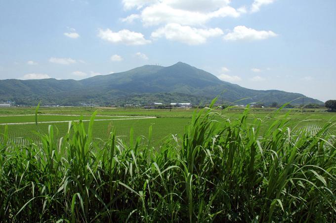
4 4 - Therefore, a classification method that can deal with distribution-free and measurement scale-free issues are indispensable. - Artificial neural networks (ANN) are among favorable methods for such kind of purpose, and they are able to integrate multisource data in the classification (Bischof et al., 1992). - This study aims to examine the effect of combining satellite images and ancillary data on land cover classification performance using a multi-layer perceptron neural network. - Tsukuba city is selected to conduct the investigation because it contains various patterns of land cover. In addition, the high-resolution image of the area is available for the validation of the result.

5 5 A view of complex landscape of the Tsukuba city
6 2. Methods 2.1 Remote sensing and ancillary data - ALOS (Advanced Land Observing Satellite), multi-spectral advanced visible near infrared 2 (AVNIR2) sensor, acquired on 20 September, Four bands of the visible and infrared spectrum were used in the classification. - Ancillary data are elevation, slope and normalized difference vegetation index (NDVI). NDVI = (NIR band4 -RED band3 )/(NIR band4 +RED band3 ). 6
7 7 2.2 Reference data - Secondary data was employed as reference data for classification and accuracy assessment. They are existing land use map of 2008 and the data of land use derived from the Google earth. -These data were used for identifying land cover types in the city, delineation of training areas and accuracy assessment. - Land use/cover classes were identified using the Tsukuba land use/cover map of 2008 with a resolution of 10 m x 10m. 2.3 Network architecture (topology) In order to examine the effect of combining ALOS and ancillary variables on classification performance, the land use/cover maps of the area were produced using different input combinations: - ALOS alone (Bands 1, 2, 3 and 4): 4 inputs - ALOS plus terrain (elevation and slope): 6 inputs - ALOS plus terrain and NDVI: 7 inputs


8 Input layer Hidden layer Output layer Band 1 W i,j W j,l Band 2 Band 3 Band 4 Land cover map Elevation Slope NDVI Figure 1: Network topology for land cover classification 8
9 2.4 Training the network for classification - Training is to derive appropriate weights between the input and hidden layer and between the hidden and the output layer for classifying unknown pixels. - The process is carried out by two steps: forward and backward steps. - In the forward step, a single hidden layer node receives is weighted according to the following: m net w j i 1 ji o i o j f ( net j Activation function for non-linear mapping ) where w ji is the weight between node i and node j o i is the input from node i. 9
10 - As forward step is completed, the computed output is compared with their desired values, and error is computed. The error is then propagated backward through the network and the weights are corrected according to the generalized delta rule (Rumelhart at al., 1986). w o w ji( t 1) ji i ji( t) where w ji is weight from input i to node j at time t, η is learning rate, α is momentum, and δ is computed error. - The learning rate controls the size of weight change. The forward and backward steps continue until the network has learned the characteristics of all classes. 10

11 11 Figure 2: Interface of neural network for classification of satellite imagery

12 Figure 3: Classification with ALOS data alone 12

13 13 Figure 4: Classification with ALOS data, elevation and slope

14 14 Figure 5: Classification with ALOS data, elevation, slope and NDVI
15 Accuracy assessment - A set of 142 pixels were collected for accuracy assessment using UM_FieldGIS, embedded Google Map API, developed by Dr. Ko Ko Lwin. - The error matrices for the classifications were generated by visually and carefully interpreting each sample pixel.

16 16 Figure 6: Forest in city area

17 17 Figure 7: Farmland


18 18 Figure 8: Paddy field

19 19 Figure 9: Urban/built in area


20 3. Results ALOS alone ALOS plus terrain data ALOS plus terrain, NDVI 20 Figure 10: Land cover maps derived from different input combinations
21 Table 1: Effect of ancillary data on spatial extent of land cover Land use/cover Extent of land cover types of different classifications in percentage ALOS data alone ALOS and terrain data ALOS, terrain and NDVI data Forest Paddy rice Farmland Urban Total Table 2: Error matrix for accuracy assessment of land cover map using ALOS data alone Reference data Classified data Forest Paddy rice Farmland Urban Total U.Acc Forest Paddy rice Farmland Urban Total P.Acc Overall accuracy Kappa index
22 Table 3: Error matrix for the accuracy assessment of land cover map using ALOS and terrain data Reference data Classified data Forest Paddy rice Farmland Urban Total U.Acc Forest Paddy rice Farmland Urban Total P.Acc Overall accuracy Kappa index 0.82 Table 4: Error matrix for the accuracy assessment of land cover map using ALOS, terrain and NDVI Reference data Classified data Forest Paddy rice Farmland Urban Total U.Acc Forest Paddy rice Farmland Urban Total P.Acc Overall accuracy Kappa index
23 4. Discussion - Topographic data and NDVI in combination with ALOS imagery improved significantly the classification accuracy from % to 90.85% in the study area (9.16%). - Comparing with other studies: Franklin (1987) integrated topographic variables as additional bands into Landsat images in a mountainous area of Canada s Yukon. The overall accuracy of land cover map improved from 46% to 75%. Maselli at al. (1995) incorporated terrain and soil data with Landsat TM in a classification in Tuscany, Italia. Kappa of the classification result increased from (Landsat data alone) to 0.91 (integration of terrain, soil and Landsat images). Harris and Vantura (1995) combined zoning and housing data with TM images. The overall classification accuracy increased by 10%. 23
24 24 - ANN have the advantage of overcoming the difficulty in merging data from multiple sources because they are distribution-free, that is, it is not required to model the data with a specified distribution. The technique allows remotely sensed and ancillary data layers to be integrated for the purpose of accuracy improvement. - More improvement may be expected using additional information such as the texture, the shape and the size of the objects in the urban setting.
25 Thank you for your kind attention! 25
Land cover/land use mapping and cha Mongolian plateau using remote sens. Title. Author(s) Bagan, Hasi; Yamagata, Yoshiki. Citation Japan.
 Bagan, Hasi; Yamagata, Yoshiki. Citation Japan.") Title Land cover/land use mapping and cha Mongolian plateau using remote sens Author(s) Bagan, Hasi; Yamagata, Yoshiki International Symposium on "The Imp Citation Region Specific Systems". 6 Nove Japan.
Title Land cover/land use mapping and cha Mongolian plateau using remote sens Author(s) Bagan, Hasi; Yamagata, Yoshiki International Symposium on "The Imp Citation Region Specific Systems". 6 Nove Japan.
Landuse and Landcover change analysis in Selaiyur village, Tambaram taluk, Chennai
 Landuse and Landcover change analysis in Selaiyur village, Tambaram taluk, Chennai K. Ilayaraja Department of Civil Engineering BIST, Bharath University Selaiyur, Chennai 73 ABSTRACT The synoptic picture
A Method to Improve the Accuracy of Remote Sensing Data Classification by Exploiting the Multi-Scale Properties in the Scene
 Proceedings of the 8th International Symposium on Spatial Accuracy Assessment in Natural Resources and Environmental Sciences Shanghai, P. R. China, June 25-27, 2008, pp. 183-188 A Method to Improve the
ESTIMATION OF LANDFORM CLASSIFICATION BASED ON LAND USE AND ITS CHANGE - Use of Object-based Classification and Altitude Data -
 ESTIMATION OF LANDFORM CLASSIFICATION BASED ON LAND USE AND ITS CHANGE - Use of Object-based Classification and Altitude Data - Shoichi NAKAI 1 and Jaegyu BAE 2 1 Professor, Chiba University, Chiba, Japan.
Preparation of LULC map from GE images for GIS based Urban Hydrological Modeling
 International Conference on Modeling Tools for Sustainable Water Resources Management Department of Civil Engineering, Indian Institute of Technology Hyderabad: 28-29 December 2014 Abstract Preparation
This is trial version
 Journal of Rangeland Science, 2012, Vol. 2, No. 2 J. Barkhordari and T. Vardanian/ 459 Contents available at ISC and SID Journal homepage: www.rangeland.ir Full Paper Article: Using Post-Classification
VISUALIZATION URBAN SPATIAL GROWTH OF DESERT CITIES FROM SATELLITE IMAGERY: A PRELIMINARY STUDY
 CO-439 VISUALIZATION URBAN SPATIAL GROWTH OF DESERT CITIES FROM SATELLITE IMAGERY: A PRELIMINARY STUDY YANG X. Florida State University, TALLAHASSEE, FLORIDA, UNITED STATES ABSTRACT Desert cities, particularly
Applications of GIS and Remote Sensing for Analysis of Urban Heat Island
 Chuanxin Zhu Professor Peter V. August Professor Yeqiao Wang NRS 509 December 15, 2016 Applications of GIS and Remote Sensing for Analysis of Urban Heat Island Since the last century, the global mean surface
Vegetation Change Detection of Central part of Nepal using Landsat TM
 Vegetation Change Detection of Central part of Nepal using Landsat TM Kalpana G. Bastakoti Department of Geography, University of Calgary, kalpanagb@gmail.com Abstract This paper presents a study of detecting
Using satellite images to calculate land use and land cover statistics
 Using satellite images to calculate land use and land cover statistics National Administrative Department of Statistics DANE Colombia April 2016 @DANE_Colombia /DANEColombia /DANEColombia Background (1)
THE EFFECT OF VEGETATION COVER ON SNOW COVER MAPPING FROM PASSIVE MICROWAVE DATA INTRODUCTION
 THE EFFECT OF VEGETATION COVER ON NOW COVER MAPPING FROM PAIVE MICROWAVE DATA Hosni Ghedira Juan Carlos Arevalo Tarendra Lakhankar Reza Khanbilvardi NOAA-CRET, City University of New York Convent Ave at
USING HYPERSPECTRAL IMAGERY
 USING HYPERSPECTRAL IMAGERY AND LIDAR DATA TO DETECT PLANT INVASIONS 2016 ESRI CANADA SCHOLARSHIP APPLICATION CURTIS CHANCE M.SC. CANDIDATE FACULTY OF FORESTRY UNIVERSITY OF BRITISH COLUMBIA CURTIS.CHANCE@ALUMNI.UBC.CA
Estimation of Wavelet Based Spatially Enhanced Evapotranspiration Using Energy Balance Approach
 Estimation of Wavelet Based Spatially Enhanced Evapotranspiration Using Energy Balance Approach Dr.Gowri 1 Dr.Thirumalaivasan 2 1 Associate Professor, Jerusalem College of Engineering, Department of Civil
An Automated Object-Oriented Satellite Image Classification Method Integrating the FAO Land Cover Classification System (LCCS).
.") An Automated Object-Oriented Satellite Image Classification Method Integrating the FAO Land Cover Classification System (LCCS). Ruvimbo Gamanya Sibanda Prof. Dr. Philippe De Maeyer Prof. Dr. Morgan De
An Automated Object-Oriented Satellite Image Classification Method Integrating the FAO Land Cover Classification System (LCCS). Ruvimbo Gamanya Sibanda Prof. Dr. Philippe De Maeyer Prof. Dr. Morgan De
URBAN LAND COVER AND LAND USE CLASSIFICATION USING HIGH SPATIAL RESOLUTION IMAGES AND SPATIAL METRICS
 URBAN LAND COVER AND LAND USE CLASSIFICATION USING HIGH SPATIAL RESOLUTION IMAGES AND SPATIAL METRICS Ivan Lizarazo Universidad Distrital, Department of Cadastral Engineering, Bogota, Colombia; ilizarazo@udistrital.edu.co
SUPPORTING INFORMATION. Ecological restoration and its effects on the
 SUPPORTING INFORMATION Ecological restoration and its effects on the regional climate: the case in the source region of the Yellow River, China Zhouyuan Li, Xuehua Liu,* Tianlin Niu, De Kejia, Qingping
Agricultural land-use from space. David Pairman and Heather North
 Agricultural land-use from space David Pairman and Heather North Talk Outline Motivation Challenges Different approach Paddock boundaries Classifications Examples Accuracy Issues Data sources Future possibilities
Contents. Introduction Study area Data and Methodology Results Conclusions
 Modelling Spatial Changes in Suburban Areas of Istanbul Using Landsat 5 TM Data Şinasi Kaya(Assoc. Prof. Dr. ITU) Elif Sertel(Assoc. Prof. Dr. ITU) Dursun Z. Şeker(Prof. Dr. ITU) 1 Contents Introduction
Land Features Extraction from Landsat TM Image Using Decision Tree Method
 www.ijrsa.org International Journal of Remote Sensing Applications (IJRSA) Volume 6, 2016 doi: 10.14355/ijrsa.2016.06.011 Land Features Extraction from Landsat TM Image Using Decision Tree Method Jason
Object Based Imagery Exploration with. Outline
 Object Based Imagery Exploration with Dan Craver Portland State University June 11, 2007 Outline Overview Getting Started Processing and Derivatives Object-oriented classification Literature review Demo
M.C.PALIWAL. Department of Civil Engineering NATIONAL INSTITUTE OF TECHNICAL TEACHERS TRAINING & RESEARCH, BHOPAL (M.P.), INDIA
, INDIA") INVESTIGATIONS ON THE ACCURACY ASPECTS IN THE LAND USE/LAND COVER MAPPING USING REMOTE SENSING SATELLITE IMAGERY By M.C.PALIWAL Department of Civil Engineering NATIONAL INSTITUTE OF TECHNICAL TEACHERS
INVESTIGATIONS ON THE ACCURACY ASPECTS IN THE LAND USE/LAND COVER MAPPING USING REMOTE SENSING SATELLITE IMAGERY By M.C.PALIWAL Department of Civil Engineering NATIONAL INSTITUTE OF TECHNICAL TEACHERS
Yanbo Huang and Guy Fipps, P.E. 2. August 25, 2006
 Landsat Satellite Multi-Spectral Image Classification of Land Cover Change for GIS-Based Urbanization Analysis in Irrigation Districts: Evaluation in Low Rio Grande Valley 1 by Yanbo Huang and Guy Fipps,
AN INVESTIGATION OF AUTOMATIC CHANGE DETECTION FOR TOPOGRAPHIC MAP UPDATING
 AN INVESTIGATION OF AUTOMATIC CHANGE DETECTION FOR TOPOGRAPHIC MAP UPDATING Patricia Duncan 1 & Julian Smit 2 1 The Chief Directorate: National Geospatial Information, Department of Rural Development and
Introduction to Machine Learning
 Introduction to Machine Learning Neural Networks Varun Chandola x x 5 Input Outline Contents February 2, 207 Extending Perceptrons 2 Multi Layered Perceptrons 2 2. Generalizing to Multiple Labels.................
Monitoring Urban Space Expansion Using Remote Sensing Data in Ha Long City, Quang Ninh Province in Vietnam
 Monitoring Urban Space Expansion Using Remote Sensing Data in Ha Long City, Quang Ninh Province in Vietnam MY Vo Chi, LAN Pham Thi, SON Tong Si, Viet Key words: VSW index, urban expansion, supervised classification.
OBJECT-BASED CLASSIFICATION USING HIGH RESOLUTION SATELLITE DATA AS A TOOL FOR MANAGING TRADITIONAL JAPANESE RURAL LANDSCAPES
 OBJECT-BASED CLASSIFICATION USING HIGH RESOLUTION SATELLITE DATA AS A TOOL FOR MANAGING TRADITIONAL JAPANESE RURAL LANDSCAPES K. Takahashi a, *, N. Kamagata a, K. Hara b a Graduate School of Informatics,
International Journal of Scientific & Engineering Research, Volume 6, Issue 7, July ISSN
 International Journal of Scientific & Engineering Research, Volume 6, Issue 7, July-2015 1428 Accuracy Assessment of Land Cover /Land Use Mapping Using Medium Resolution Satellite Imagery Paliwal M.C &.
DEVELOPMENT OF DIGITAL CARTOGRAPHIC DATABASE FOR MANAGING THE ENVIRONMENT AND NATURAL RESOURCES IN THE REPUBLIC OF SERBIA
 DEVELOPMENT OF DIGITAL CARTOGRAPHIC BASE FOR MANAGING THE ENVIRONMENT AND NATURAL RESOURCES IN THE REPUBLIC OF SERBIA Dragutin Protic, Ivan Nestorov Institute for Geodesy, Faculty of Civil Engineering,
Lecture 4: Perceptrons and Multilayer Perceptrons
 Lecture 4: Perceptrons and Multilayer Perceptrons Cognitive Systems II - Machine Learning SS 2005 Part I: Basic Approaches of Concept Learning Perceptrons, Artificial Neuronal Networks Lecture 4: Perceptrons
Data Fusion and Multi-Resolution Data
 Data Fusion and Multi-Resolution Data Nature.com www.museevirtuel-virtualmuseum.ca www.srs.fs.usda.gov Meredith Gartner 3/7/14 Data fusion and multi-resolution data Dark and Bram MAUP and raster data Hilker
CHANGE DETECTION USING REMOTE SENSING- LAND COVER CHANGE ANALYSIS OF THE TEBA CATCHMENT IN SPAIN (A CASE STUDY)
") CHANGE DETECTION USING REMOTE SENSING- LAND COVER CHANGE ANALYSIS OF THE TEBA CATCHMENT IN SPAIN (A CASE STUDY) Sharda Singh, Professor & Programme Director CENTRE FOR GEO-INFORMATICS RESEARCH AND TRAINING
CHANGE DETECTION USING REMOTE SENSING- LAND COVER CHANGE ANALYSIS OF THE TEBA CATCHMENT IN SPAIN (A CASE STUDY) Sharda Singh, Professor & Programme Director CENTRE FOR GEO-INFORMATICS RESEARCH AND TRAINING
Urban Growth Analysis: Calculating Metrics to Quantify Urban Sprawl
 Urban Growth Analysis: Calculating Metrics to Quantify Urban Sprawl Jason Parent jason.parent@uconn.edu Academic Assistant GIS Analyst Daniel Civco Professor of Geomatics Center for Land Use Education
GLOBAL/CONTINENTAL LAND COVER MAPPING AND MONITORING
 GLOBAL/CONTINENTAL LAND COVER MAPPING AND MONITORING Ryutaro Tateishi, Cheng Gang Wen, and Jong-Geol Park Center for Environmental Remote Sensing (CEReS), Chiba University 1-33 Yayoi-cho Inage-ku Chiba
Critical Assessment of Land Use Land Cover Dynamics Using Multi-Temporal Satellite Images
 Environments 2015, 2, 61-90; doi:10.3390/environments2010061 OPEN ACCESS environments ISSN 2076-3298 www.mdpi.com/journal/environments Article Critical Assessment of Land Use Land Cover Dynamics Using
STUDY OF NORMALIZED DIFFERENCE BUILT-UP (NDBI) INDEX IN AUTOMATICALLY MAPPING URBAN AREAS FROM LANDSAT TM IMAGERY
 INDEX IN AUTOMATICALLY MAPPING URBAN AREAS FROM LANDSAT TM IMAGERY") STUDY OF NORMALIZED DIFFERENCE BUILT-UP (NDBI) INDEX IN AUTOMATICALLY MAPPING URBAN AREAS FROM LANDSAT TM IMAGERY Dr. Hari Krishna Karanam Professor, Civil Engineering, Dadi Institute of Engineering &
STUDY OF NORMALIZED DIFFERENCE BUILT-UP (NDBI) INDEX IN AUTOMATICALLY MAPPING URBAN AREAS FROM LANDSAT TM IMAGERY Dr. Hari Krishna Karanam Professor, Civil Engineering, Dadi Institute of Engineering &
Spatial Planning Platform Meeting
 Spatial Planning Platform Meeting August 1 st 2018 Part II Session 1 Design and Implementation of National and Regional Planning for Inclusive Growth Spatial info from space based technologies RESTEC (Remote
doi: /
 doi: 10.1080/15481603.2013.814279 Evaluation of Land Cover Classification Based on Multispectral versus Pansharpened Landsat ETM+ Imagery Ko Ko Lwin and Yuji Murayama Division of Spatial Information Science
Urban remote sensing: from local to global and back
 Urban remote sensing: from local to global and back Paolo Gamba University of Pavia, Italy A few words about Pavia Historical University (1361) in a nice town slide 3 Geoscience and Remote Sensing Society
Use of Corona, Landsat TM, Spot 5 images to assess 40 years of land use/cover changes in Cavusbasi
 New Strategies for European Remote Sensing, Olui (ed.) 2005 Millpress, Rotterdam, ISBN 90 5966 003 X Use of Corona, Landsat TM, Spot 5 images to assess 40 years of land use/cover changes in Cavusbasi N.
IMPROVING REMOTE SENSING-DERIVED LAND USE/LAND COVER CLASSIFICATION WITH THE AID OF SPATIAL INFORMATION
 IMPROVING REMOTE SENSING-DERIVED LAND USE/LAND COVER CLASSIFICATION WITH THE AID OF SPATIAL INFORMATION Yingchun Zhou1, Sunil Narumalani1, Dennis E. Jelinski2 Department of Geography, University of Nebraska,
Advanced Image Analysis in Disaster Response
 Advanced Image Analysis in Disaster Response Creating Geographic Knowledge Thomas Harris ITT The information contained in this document pertains to software products and services that are subject to the
DETECTION AND ANALYSIS OF LAND-USE/LAND-COVER CHANGES IN NAY PYI TAW, MYANMAR USING SATELLITE REMOTE SENSING IMAGES
 DETECTION AND ANALYSIS OF LAND-USE/LAND-COVER CHANGES IN NAY PYI TAW, MYANMAR USING SATELLITE REMOTE SENSING IMAGES Kay Khaing Oo 1, Eiji Nawata 1, Kiyoshi Torii 2 and Ke-Sheng Cheng 3 1 Division of Environmental
CHAPTER-7 INTERFEROMETRIC ANALYSIS OF SPACEBORNE ENVISAT-ASAR DATA FOR VEGETATION CLASSIFICATION
 147 CHAPTER-7 INTERFEROMETRIC ANALYSIS OF SPACEBORNE ENVISAT-ASAR DATA FOR VEGETATION CLASSIFICATION 7.1 INTRODUCTION: Interferometric synthetic aperture radar (InSAR) is a rapidly evolving SAR remote
ASSESSMENT OF NDVI FOR DIFFERENT LAND COVERS BEFORE AND AFTER ATMOSPHERIC CORRECTIONS
 Bulletin of the Transilvania University of Braşov Series II: Forestry Wood Industry Agricultural Food Engineering Vol. 7 (56) No. 1-2014 ASSESSMENT OF NDVI FOR DIFFERENT LAND COVERS BEFORE AND AFTER ATMOSPHERIC
Progress and Land-Use Characteristics of Urban Sprawl in Busan Metropolitan City using Remote sensing and GIS
 Progress and Land-Use Characteristics of Urban Sprawl in Busan Metropolitan City using Remote sensing and GIS Homyung Park, Taekyung Baek, Yongeun Shin, Hungkwan Kim ABSTRACT Satellite image is very usefully
Investigation of the Effect of Transportation Network on Urban Growth by Using Satellite Images and Geographic Information Systems
 Presented at the FIG Congress 2018, May 6-11, 2018 in Istanbul, Turkey Investigation of the Effect of Transportation Network on Urban Growth by Using Satellite Images and Geographic Information Systems
Quick Response Report #126 Hurricane Floyd Flood Mapping Integrating Landsat 7 TM Satellite Imagery and DEM Data
 Quick Response Report #126 Hurricane Floyd Flood Mapping Integrating Landsat 7 TM Satellite Imagery and DEM Data Jeffrey D. Colby Yong Wang Karen Mulcahy Department of Geography East Carolina University
EPL442: Computational
 EPL442: Computational Learning Systems Lab 2 Vassilis Vassiliades Department of Computer Science University of Cyprus Outline Artificial Neuron Feedforward Neural Network Back-propagation Algorithm Notes
DEPENDENCE OF URBAN TEMPERATURE ELEVATION ON LAND COVER TYPES. Ping CHEN, Soo Chin LIEW and Leong Keong KWOH
 DEPENDENCE OF URBAN TEMPERATURE ELEVATION ON LAND COVER TYPES Ping CHEN, Soo Chin LIEW and Leong Keong KWOH Centre for Remote Imaging, Sensing and Processing, National University of Singapore, Lower Kent
Classification of High Spatial Resolution Remote Sensing Images Based on Decision Fusion
 Journal of Advances in Information Technology Vol. 8, No. 1, February 2017 Classification of High Spatial Resolution Remote Sensing Images Based on Decision Fusion Guizhou Wang Institute of Remote Sensing
STUDY ON RELATION BETWEEN URBAN STRUCTURE AND LAND VALUE FACTORS IN THE TOKYO METROPOLIS USING GEOGRAPHIC INFORMATION SYSTEM (GIS)
") STUDY ON RELATION BETWEEN URBAN STRUCTURE AND LAND VALUE FACTORS IN THE TOKYO METROPOLIS USING GEOGRAPHIC INFORMATION SYSTEM (GIS) Ippei Harada 1, Akihiko Kondoh 2 1 Center for Environmental Remote Sensing,
STUDY ON RELATION BETWEEN URBAN STRUCTURE AND LAND VALUE FACTORS IN THE TOKYO METROPOLIS USING GEOGRAPHIC INFORMATION SYSTEM (GIS) Ippei Harada 1, Akihiko Kondoh 2 1 Center for Environmental Remote Sensing,
What is a vegetation index?
 Vegetation indexes What is a vegetation index? A tool: a vegetation index is a mathematical formula used to estimate the likelihood of vegetation presence in remotely sensed data A product: the result
A DATA FIELD METHOD FOR URBAN REMOTELY SENSED IMAGERY CLASSIFICATION CONSIDERING SPATIAL CORRELATION
 The International Archives of the Photogrammetry, Remote Sensing and Spatial Information Sciences, Volume XLI-B7, 016 XXIII ISPRS Congress, 1 19 July 016, Prague, Czech Republic A DATA FIELD METHOD FOR
Digital Change Detection Using Remotely Sensed Data for Monitoring Green Space Destruction in Tabriz
 Int. J. Environ. Res. 1 (1): 35-41, Winter 2007 ISSN:1735-6865 Graduate Faculty of Environment University of Tehran Digital Change Detection Using Remotely Sensed Data for Monitoring Green Space Destruction
AUTOMATED BUILDING DETECTION FROM HIGH-RESOLUTION SATELLITE IMAGE FOR UPDATING GIS BUILDING INVENTORY DATA
 13th World Conference on Earthquake Engineering Vancouver, B.C., Canada August 1-6, 2004 Paper No. 678 AUTOMATED BUILDING DETECTION FROM HIGH-RESOLUTION SATELLITE IMAGE FOR UPDATING GIS BUILDING INVENTORY
Community Identification Based on Multispectral Image Classification for Local Electric Power Distribution Systems
 Community Identification Based on Multispectral Image Classification for Local Electric Power Distribution Systems TATIYA LUEMONGKOL and THANATCHAI KULWORAWANICHPONG Power System Research Unit School of
Land Use/Cover Changes & Modeling Urban Expansion of Nairobi City
 Land Use/Cover Changes & Modeling Urban Expansion of Nairobi City Overview Introduction Objectives Land use/cover changes Modeling with Cellular Automata Conclusions Introduction Urban land use/cover types
Geospatial technology for land cover analysis
 Home Articles Application Environment & Climate Conservation & monitoring Published in : Middle East & Africa Geospatial Digest November 2013 Lemenkova Polina Charles University in Prague, Faculty of Science,
A Logarithmic Neural Network Architecture for Unbounded Non-Linear Function Approximation
 1 Introduction A Logarithmic Neural Network Architecture for Unbounded Non-Linear Function Approximation J Wesley Hines Nuclear Engineering Department The University of Tennessee Knoxville, Tennessee,
THE APPLICATION OF NEURAL NETWORKS TO THE FLORISTIC CLASSIFICATION OF REMOTE SENSING AND GIS DATA IN COMPLEX TERRAIN.
 THE APPLICATION OF NEURAL NETWORKS TO THE FLORISTIC CLASSIFICATION OF REMOTE SENSING AND GIS DATA IN COMPLEX TERRAIN. R.W. Fitzgerald & B.G. Lees Geography Department, Australian National University, PO
DETECTION OF CHANGES IN FOREST LANDCOVER TYPE AFTER FIRES IN PORTUGAL
 DETECTION OF CHANGES IN FOREST LANDCOVER TYPE AFTER FIRES IN PORTUGAL Paulo M. Barbosa, Mário R. Caetano, and Teresa G. Santos Centro Nacional de Informação Geográfica (CNIG), Portugal barp@cnig.pt, mario@cnig.pt,
Land Use and Land Cover Detection by Different Classification Systems using Remotely Sensed Data of Kuala Tiga, Tanah Merah Kelantan, Malaysia
 Land Use and Land Cover Detection by Different Classification Systems using Remotely Sensed Data of Kuala Tiga, Tanah Merah Kelantan, Malaysia Wani Sofia Udin*, Zuhaira Nadhila Zahuri Faculty of Earth
DAMAGE DETECTION OF THE 2008 SICHUAN, CHINA EARTHQUAKE FROM ALOS OPTICAL IMAGES
 DAMAGE DETECTION OF THE 2008 SICHUAN, CHINA EARTHQUAKE FROM ALOS OPTICAL IMAGES Wen Liu, Fumio Yamazaki Department of Urban Environment Systems, Graduate School of Engineering, Chiba University, 1-33,
The Study of Multi-temporal Analysis of Urban Development and Environmental Changes of the City of Abu Dhabi
 The Study of Multi-temporal Analysis of Urban Development and Environmental Changes of the City of Abu Dhabi H. Hussein and M. Hussein Abstract The city of Abu Dhabi is the capital of the United Arab Emirates.
Sparse Representation-based Analysis of Hyperspectral Remote Sensing Data
 Sparse Representation-based Analysis of Hyperspectral Remote Sensing Data Ribana Roscher Institute of Geodesy and Geoinformation Remote Sensing Group, University of Bonn 1 Remote Sensing Image Data Remote
Unit III. A Survey of Neural Network Model
 Unit III A Survey of Neural Network Model 1 Single Layer Perceptron Perceptron the first adaptive network architecture was invented by Frank Rosenblatt in 1957. It can be used for the classification of
Land Use/Cover Changes in the rural-urban interaction of Xi an Region, West China, using Lansat TM/ETM data
 Land Use/Cover Changes in the rural-urban interaction of Xi an Region, West China, using Lansat TM/ETM data Jiang Jian-Jun 1), 2), Zhou Jie 2), Wu Hong-an 1), Ai Li 2), Zhang Hai-Long 1), Zhang Li 1) and
Land Cover Modeling Report
 Land Cover Modeling Report Submitted to International Centre for Integrated Mountain Development (ICIMOD) Submitted by BUET-Japan Institute of Disaster Prevention and Urban Safety (BUET-JIDPUS); Bangladesh
Ajoke Onojeghuo & Alex Onojeghuo (Nigeria)
") Mapping and Predicting Urban Sprawl Using Remote Sensing and Geographic Information System Techniques: A Case Study of Eti-Osa Local Government Area, Lagos, Nigeria Ajoke Onojeghuo & Alex Onojeghuo (Nigeria)
Mapping and Predicting Urban Sprawl Using Remote Sensing and Geographic Information System Techniques: A Case Study of Eti-Osa Local Government Area, Lagos, Nigeria Ajoke Onojeghuo & Alex Onojeghuo (Nigeria)
Neural Networks, Computation Graphs. CMSC 470 Marine Carpuat
 Neural Networks, Computation Graphs CMSC 470 Marine Carpuat Binary Classification with a Multi-layer Perceptron φ A = 1 φ site = 1 φ located = 1 φ Maizuru = 1 φ, = 2 φ in = 1 φ Kyoto = 1 φ priest = 0 φ
Artificial Neural Networks
 Introduction ANN in Action Final Observations Application: Poverty Detection Artificial Neural Networks Alvaro J. Riascos Villegas University of los Andes and Quantil July 6 2018 Artificial Neural Networks
1 Introduction: 2 Data Processing:
 Darren Janzen University of Northern British Columbia Student Number 230001222 Major: Forestry Minor: GIS/Remote Sensing Produced for: Geography 413 (Advanced GIS) Fall Semester Creation Date: November
Introduction to Satellite Derived Vegetation Indices
 Introduction to the Use of Geospatial Information Technology for Drought Risk Management 13-17 November, 2017 Tonle Bassac II Restaurant, Phnom Penh, Cambodia Introduction to Satellite Derived Vegetation
y(x n, w) t n 2. (1)
 t n 2. (1)") Network training: Training a neural network involves determining the weight parameter vector w that minimizes a cost function. Given a training set comprising a set of input vector {x n }, n = 1,...N,
Network training: Training a neural network involves determining the weight parameter vector w that minimizes a cost function. Given a training set comprising a set of input vector {x n }, n = 1,...N,
Fundamentals of Remote Sensing
 Division of Spatial Information Science Graduate School Life and Environment Sciences University of Tsukuba Fundamentals of Remote Sensing Prof. Dr. Yuji Murayama Surantha Dassanayake 10/6/2010 1 Fundamentals
Temporal and spatial approaches for land cover classification.
 Temporal and spatial approaches for land cover classification. Ryabukhin Sergey sergeyryabukhin@gmail.com Abstract. This paper describes solution for Time Series Land Cover Classification Challenge (TiSeLaC).
Speaker Representation and Verification Part II. by Vasileios Vasilakakis
 Speaker Representation and Verification Part II by Vasileios Vasilakakis Outline -Approaches of Neural Networks in Speaker/Speech Recognition -Feed-Forward Neural Networks -Training with Back-propagation
Object Based Land Cover Extraction Using Open Source Software
 Object Based Land Cover Extraction Using Open Source Software Abhasha Joshi 1, Janak Raj Joshi 2, Nawaraj Shrestha 3, Saroj Sreshtha 4, Sudarshan Gautam 5 1 Instructor, Land Management Training Center,
AN INTEGRATED METHOD FOR FOREST CANOPY COVER MAPPING USING LANDSAT ETM+ IMAGERY INTRODUCTION
 AN INTEGRATED METHOD FOR FOREST CANOPY COVER MAPPING USING LANDSAT ETM+ IMAGERY Zhongwu Wang, Remote Sensing Analyst Andrew Brenner, General Manager Sanborn Map Company 455 E. Eisenhower Parkway, Suite
History & Scope of Remote Sensing FOUNDATIONS
 History & Scope of Remote Sensing FOUNDATIONS Lecture Overview Introduction Overview of visual information Power of imagery Definition What is remote sensing? Definition standard for class History of Remote
CHAPTER 2 REMOTE SENSING IN URBAN SPRAWL ANALYSIS
 9 CHAPTER 2 REMOTE SENSING IN URBAN SPRAWL ANALYSIS 2.1. REMOTE SENSING Remote sensing is the science of acquiring information about the Earth's surface without actually being in contact with it. This
AGOG 485/585 /APLN 533 Spring Lecture 5: MODIS land cover product (MCD12Q1). Additional sources of MODIS data
. Additional sources of MODIS data") AGOG 485/585 /APLN 533 Spring 2019 Lecture 5: MODIS land cover product (MCD12Q1). Additional sources of MODIS data Outline Current status of land cover products Overview of the MCD12Q1 algorithm Mapping
AGOG 485/585 /APLN 533 Spring 2019 Lecture 5: MODIS land cover product (MCD12Q1). Additional sources of MODIS data Outline Current status of land cover products Overview of the MCD12Q1 algorithm Mapping
Neural Networks biological neuron artificial neuron 1
 Neural Networks biological neuron artificial neuron 1 A two-layer neural network Output layer (activation represents classification) Weighted connections Hidden layer ( internal representation ) Input
REMOTE SENSING ACTIVITIES. Caiti Steele
 REMOTE SENSING ACTIVITIES Caiti Steele REMOTE SENSING ACTIVITIES Remote sensing of biomass: Field Validation of Biomass Retrieved from Landsat for Rangeland Assessment and Monitoring (Browning et al.,
Unit 8: Introduction to neural networks. Perceptrons
 Unit 8: Introduction to neural networks. Perceptrons D. Balbontín Noval F. J. Martín Mateos J. L. Ruiz Reina A. Riscos Núñez Departamento de Ciencias de la Computación e Inteligencia Artificial Universidad
Fundamentals of Photographic Interpretation
 Principals and Elements of Image Interpretation Fundamentals of Photographic Interpretation Observation and inference depend on interpreter s training, experience, bias, natural visual and analytical abilities.
Multilayer Perceptrons and Backpropagation
 Multilayer Perceptrons and Backpropagation Informatics 1 CG: Lecture 7 Chris Lucas School of Informatics University of Edinburgh January 31, 2017 (Slides adapted from Mirella Lapata s.) 1 / 33 Reading:
Chapter ML:VI (continued)
") Chapter ML:VI (continued) VI Neural Networks Perceptron Learning Gradient Descent Multilayer Perceptron Radial asis Functions ML:VI-64 Neural Networks STEIN 2005-2018 Definition 1 (Linear Separability)
Chapter ML:VI (continued) VI Neural Networks Perceptron Learning Gradient Descent Multilayer Perceptron Radial asis Functions ML:VI-64 Neural Networks STEIN 2005-2018 Definition 1 (Linear Separability)
LAND COVER CLASSIFICATION OF ALOS DATA USING BACK-PROPAGATION NEURAL NETWORK MODELS ARIANI ANDAYANI
 LAND COVER CLASSIFICATION OF ALOS DATA USING BACK-PROPAGATION NEURAL NETWORK MODELS ARIANI ANDAYANI GRADUATE SCHOOL BOGOR AGRICULTURAL UNIVERSITY BOGOR 2008 STATEMENT Hereby I, Ariani Andayani, do declare
GEO 874 Remote Sensing. Zihan Lin, Nafiseh Hagtalab, Ranjeet John
 GEO 874 Remote Sensing Zihan Lin, Nafiseh Hagtalab, Ranjeet John http://onlinelibrary.wiley.com/doi/10.1002/wat2.1147/full Landscape Heterogeneity S-I: homogeneous landscape using only cropland for the
Artificial Neural Networks. Historical description
 Artificial Neural Networks Historical description Victor G. Lopez 1 / 23 Artificial Neural Networks (ANN) An artificial neural network is a computational model that attempts to emulate the functions of
Scientific registration n : 2180 Symposium n : 35 Presentation : poster MULDERS M.A.
 Scientific registration n : 2180 Symposium n : 35 Presentation : poster GIS and Remote sensing as tools to map soils in Zoundwéogo (Burkina Faso) SIG et télédétection, aides à la cartographie des sols
Comparison between Land Surface Temperature Retrieval Using Classification Based Emissivity and NDVI Based Emissivity
 Comparison between Land Surface Temperature Retrieval Using Classification Based Emissivity and NDVI Based Emissivity Isabel C. Perez Hoyos NOAA Crest, City College of New York, CUNY, 160 Convent Avenue,
Introduction Neural Networks - Architecture Network Training Small Example - ZIP Codes Summary. Neural Networks - I. Henrik I Christensen
 Neural Networks - I Henrik I Christensen Robotics & Intelligent Machines @ GT Georgia Institute of Technology, Atlanta, GA 30332-0280 hic@cc.gatech.edu Henrik I Christensen (RIM@GT) Neural Networks 1 /
An Internet-based Agricultural Land Use Trends Visualization System (AgLuT)
") An Internet-based Agricultural Land Use Trends Visualization System (AgLuT) Prepared for Missouri Department of Natural Resources Missouri Department of Conservation 07-01-2000-12-31-2001 Submitted by
An Internet-based Agricultural Land Use Trends Visualization System (AgLuT) Prepared for Missouri Department of Natural Resources Missouri Department of Conservation 07-01-2000-12-31-2001 Submitted by
Lesson 4b Remote Sensing and geospatial analysis to integrate observations over larger scales
 Lesson 4b Remote Sensing and geospatial analysis to integrate observations over larger scales We have discussed static sensors, human-based (participatory) sensing, and mobile sensing Remote sensing: Satellite
Application of Goodall's Affinity Index in Remote Sensing Image Classification
 Application of Goodall's Affinity Index in Remote Sensing Image Classification A. Altobelli*, E. Feoli *, B. Boglich Perasti* *Department of Biology, University of Trieste, Italy. Abstract The affinity
Machine Learning to Automatically Detect Human Development from Satellite Imagery
 Technical Disclosure Commons Defensive Publications Series April 24, 2017 Machine Learning to Automatically Detect Human Development from Satellite Imagery Matthew Manolides Follow this and additional
STUDY ON FOREST VEGETATION CLASSIFICATION BASED ON MULTI- TEMPORAL REMOTE SENSING IMAGES
 STUDY ON FOREST VEGETATION CLASSIFICATION BASED ON MULTI- TEMPORAL REMOTE SENSING IMAGES Xia Jing 1, 2, JiHua Wang 2, WenJiang Huang 2,*, LiangYun Liu 2, JinDi Wang 1 1 School of Geography, Beijing Normal
Land cover classification methods
 Land cover classification methods This document provides an overview of land cover classification using remotely sensed data. We will describe different options for conducting land cover classification