Digital Elevation Models (DEM) / DTM
|
|
|
- Marvin York
- 5 years ago
- Views:
Transcription

 Digital Surface Models Spaceborne")
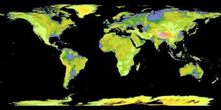
1 Digital Elevation Models (DEM) / DTM Uses in remote sensing: queries and analysis, 3D visualisation, classification input Fogo Island, Cape Verde Republic ASTER DEM / image Banks Peninsula, Christchurch, New Zealand Digital Terrain Models Photogrammetric (and LiDAR) Digital Surface Models Spaceborne (and LiDAR) 1


2 Almost all DEMs have been created from remote sensing: a. DEMs from digitising contours (e.g. NTDB) The earliest were created by digitising contours on maps into layers stereo photos -> contour lines -> digitised lines -> interpolate to raster grid Arcmap: topo to raster PCI geomatica: vdemint b. Digital Stereo photogrammetry: (e.g. BC TRIM) Mass points (70 metre spacing) captured from aerial photographs stereo photos -> mass points -> interpolate to raster grid 2
 Elevation in metres = 16 bit DNs 0-65,535 (unsigned) or ± 32,767")

 LiDAR and Digital")
3 BC TRIM DEM 25metre grid Interpolated to 25m grid By 1:250,000 map sheets (100 tiles assembled together) Elevation in metres = 16 bit DNs 0-65,535 (unsigned) or ± 32,767 (signed) Or 32 bit (real) - interpolated for invalid numbers e.g. across border into AB Post 2000 methods c. Direct image grid DEM data from imagery RADAR e.g. Shuttle Radar Topographic Mission (SRTM) Stereo digital satellite imagery (adjacent or directed satellite tracks) LiDAR and Digital photogrammetry Issues: cloud cover and missing data ASTER SPOT 3
 Feb 2000 90 metre pixels, 56ºS")

4 SRTM (Shuttle Radar Topographic Mission) Feb metre pixels, 56ºS - 60ºN latitude e.g. Google Earth ASTER GDEM global 30m pixels cloud cover issue and consistency Global DEM (ASTER) 4
 Resolutions and datasets available: NTDB 25m (Canada) TRIM 25m (BC only) ASTER 30m (global) with holes SRTM 90m (near global) Download Canadian data (interpolated from")
5 ASTER image and DEM : Svalbard, Norway (15 metre resolution) DEM availability A DEM is a continuous grid of elevation values one height value per pixel.. in a channel (not a band) Resolutions and datasets available: NTDB 25m (Canada) TRIM 25m (BC only) ASTER 30m (global) with holes SRTM 90m (near global) Download Canadian data (interpolated from contours) : geogratis.ca * BC is provincial TRIM data (25m) resampled for NTDB 5
 or 32 bit (after interpolation)")
 A cartographic layer, DN= 0-255 (relative amount of light reflected), as")

6 1. Elevation ( DEM ) DEM - layers DN = (metres, 16 bit): represented onscreen as grayscale or pseudocolour tints; DEMs are stored as integer elevations (metres) or 32 bit (after interpolation) some (NTS) DEM tiles in Canada may still be in feet. conversion = Shaded relief (hillshade) A cartographic layer, DN= (relative amount of light reflected), as grayscale; light source can be selected, usually from the NW. High values on NW facing slopes, low values on SE facing slopes. Select light source azimuth and angle Default = 315, 45 useful to detect errors and assess DEM quality 6
 must be projected")


7 DEM data stored in geographic (lat/long) must be projected Reprojection can cause striping and artifacts Avoid reprojecting rasters if possible : - Reproject vectors first e.g. topo to raster Stripes often caused by WGS84 -> NAD83 Holes: due to clouds (GDEM) 7
 slope is rise/run =")


8 3. Slope Calculated in degrees (0-90) or % (0 -> infinity) slope is rise/run = vertical change over the horizontal distance 8 bit results should be adequate for most purposes 4. Aspect: the compass direction a slope is facing DN = (360) Displayed as grayscale pseudocolour Darker for lower DN (0-> ), brighter for higher DN ( -> 359) 8
 north facing slopes have both extreme values, 0 and 359 (360) so aspect CANNOT be used as a classification layer instead, we use -> 5.")
9 4. Aspect: the compass direction a slope is facing This raises three questions : flat slopes have no value (they are given an arbitrary value, e.g. 510) requires 16 bit data, so. Geomatica default converts to 8 bit by dividing by 2 (flat = 255) north facing slopes have both extreme values, 0 and 359 (360) so aspect CANNOT be used as a classification layer instead, we use -> 5. Incidence DN is related to the reflection based on sun angle (0-90) 9
 to shaded relief, but DN 0-90 the")


10 Incidence looks similar (inverted!) to shaded relief, but DN 0-90 the angle (degree) of light incidence, based on the sun position Requires metadata for sun elevation and azimuth for the scene Azimuth = sun s compass direction Elevation = height of sun Solar zenith = 90 - elevation 10


11 6. 3D perspectives / fly-throughs FLY e.g. Google Earth, ArcScene etc.. Directed high res sensors- Ikonos 1999: 4 m 11
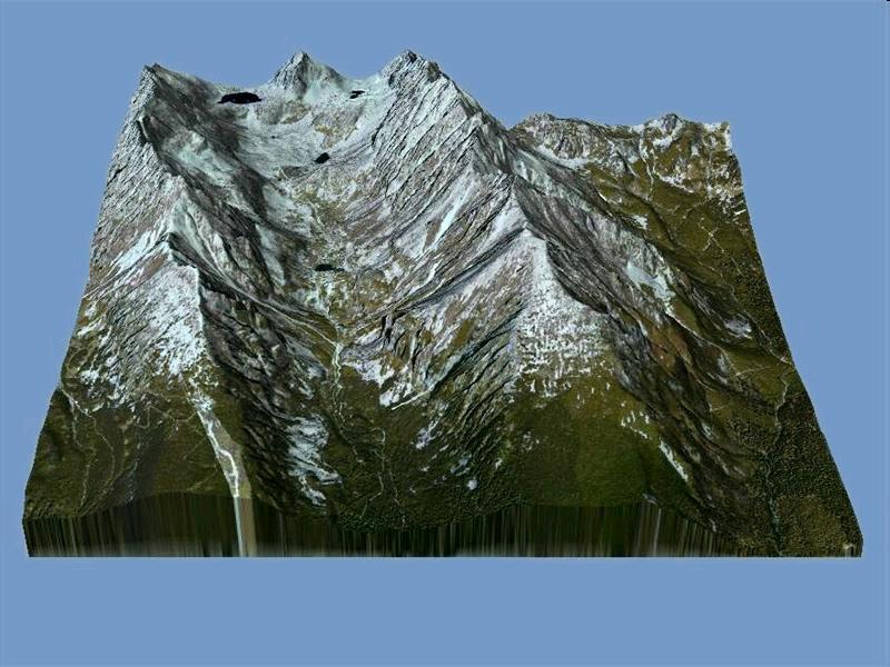
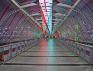
12 DEM from Photogrammetry: Tatras, Slovakia 2m 7. Anaglyphs St-Pierre Miquelon SRTM DEM 12

13 Klinakline Glacier, south Coast Mountains (ASTER DEM) N 8. DEMs in Digital Image Classification strategies for reducing mountain shadows effect Input channels for classification: Raw bands e.g. TM 3,4,5 / OLI 6,5,4 PLUS 1. Ratios / Indices 2. Transform components (e.g. Tassel Cap greeness, PCA) 3. DEM Elevation Slope (gradient) Incidence (not aspect) 13


14 Example: Land Cover Classification Using IRS LISS III Image and DEM in Rugged Terrain: A Case Study in Himalayas 1 Green 2 Red 3 NIR 4 MIR 5 NDVI 6 DEM 14
 S 15")
15 7. Anaglyphs (and 3D onscreen) St-Pierre Miquelon SRTM DEM Klinakline Glacier, south Coast Mountains (ASTER DEM) S 15
Digital Elevation Models (DEM) / DTM
 / DTM") Digital Elevation Models (DEM) / DTM Uses in remote sensing: queries and analysis, 3D visualisation, layers in classification Fogo Island, Cape Verde Republic ASTER DEM / image Banks Peninsula, Christchurch,
Digital Elevation Models (DEM) / DTM Uses in remote sensing: queries and analysis, 3D visualisation, layers in classification Fogo Island, Cape Verde Republic ASTER DEM / image Banks Peninsula, Christchurch,
Digital Elevation Models (DEM)
") Digital Elevation Models (DEM) Digital representation of the terrain surface enable 2.5 / 3D views Rule #1: they are models, not reality Rule #2: they always include some errors (subject to scale and data
Digital Elevation Models (DEM) Digital representation of the terrain surface enable 2.5 / 3D views Rule #1: they are models, not reality Rule #2: they always include some errors (subject to scale and data
ENGRG Introduction to GIS
 ENGRG 59910 Introduction to GIS Michael Piasecki March 17, 2014 Lecture 08: Terrain Analysis Outline: Terrain Analysis Earth Surface Representation Contour TIN Mass Points Digital Elevation Models Slope
ENGRG Introduction to GIS
 ENGRG 59910 Introduction to GIS Michael Piasecki November 17, 2017 Lecture 11: Terrain Analysis Outline: Terrain Analysis Earth Surface Representation Contour TIN Mass Points Digital Elevation Models Slope
ACCURACY ASSESSMENT OF ASTER GLOBAL DEM OVER TURKEY
 ACCURACY ASSESSMENT OF ASTER GLOBAL DEM OVER TURKEY E. Sertel a a ITU, Civil Engineering Faculty, Geomatic Engineering Department, 34469 Maslak Istanbul, Turkey sertele@itu.edu.tr Commission IV, WG IV/6
SPOT DEM Product Description
 SPOT DEM Product Description Version 1.1 - May 1 st, 2004 This edition supersedes previous versions Acronyms DIMAP DTED DXF HRS JPEG, JPG DEM SRTM SVG Tiff - GeoTiff XML Digital Image MAP encapsulation
AN EVALUATION OF SRTM, ASTER, AND CONTOUR BASED DEMS IN THE CARIBBEAN REGION
 Peter G. Chirico Geographer USGS, Earth Surface Processes Team 12201 Sunrise Valley Drive National Center, MS926A Reston VA, 20192 pchirico@usgs.gov AN EVALUATION OF SRTM, ASTER, AND CONTOUR BASED DEMS
Stellenbosch University Digital Elevation Model (SUDEM) 2013 Edition
 2013 Edition") Stellenbosch University Digital Elevation Model (SUDEM) 2013 Edition Adriaan van Niekerk Centre for Geographical Analysis Stellenbosch University 25 April 2014 CONTENTS CONTENTS... ii TABLES... iii FIGURES...
Stellenbosch University Digital Elevation Model (SUDEM) 2013 Edition Adriaan van Niekerk Centre for Geographical Analysis Stellenbosch University 25 April 2014 CONTENTS CONTENTS... ii TABLES... iii FIGURES...
Data Quality and Uncertainty
 Data Quality and Uncertainty The power of GIS analysis is based on the assembly of layers of data, but as data layers increase, errors multiply - quality decreases. Garbage in, garbage out. High quality
Data Quality and Uncertainty. Accuracy, Precision, Data quality and Errors
 Data Quality and Uncertainty The power of GIS analysis is based on the assembly of layers of data, but as data layers increase, errors multiply (and quality decreases). Garbage in, garbage out. High quality
USING GIS CARTOGRAPHIC MODELING TO ANALYSIS SPATIAL DISTRIBUTION OF LANDSLIDE SENSITIVE AREAS IN YANGMINGSHAN NATIONAL PARK, TAIWAN
 CO-145 USING GIS CARTOGRAPHIC MODELING TO ANALYSIS SPATIAL DISTRIBUTION OF LANDSLIDE SENSITIVE AREAS IN YANGMINGSHAN NATIONAL PARK, TAIWAN DING Y.C. Chinese Culture University., TAIPEI, TAIWAN, PROVINCE
GIS and Remote Sensing
 Spring School Land use and the vulnerability of socio-ecosystems to climate change: remote sensing and modelling techniques GIS and Remote Sensing Katerina Tzavella Project Researcher PhD candidate Technology
A Study On The Usabılıty Of Dıgıtal Elevatıon Models Obtaıned From Open Sources In The Productıon Of Contours: Comparıson Of Alos And Srtm Dem Data
 A Study On The Usabılıty Of Dıgıtal Elevatıon Models Obtaıned From Open Sources In The Productıon Of Contours: Comparıson Of Alos And Srtm Dem Data S.Cabuk a, A.C. Kiracı, M.Kaya, M.Erdogan, O.Eker, A.Okul
Determining the Location of the Simav Fault
 Lindsey German May 3, 2012 Determining the Location of the Simav Fault 1. Introduction and Problem Formulation: The issue I will be focusing on involves interpreting the location of the Simav fault in
DAMAGE DETECTION OF THE 2008 SICHUAN, CHINA EARTHQUAKE FROM ALOS OPTICAL IMAGES
 DAMAGE DETECTION OF THE 2008 SICHUAN, CHINA EARTHQUAKE FROM ALOS OPTICAL IMAGES Wen Liu, Fumio Yamazaki Department of Urban Environment Systems, Graduate School of Engineering, Chiba University, 1-33,
SPOT DEM Precision Product description
 SPOT DEM Precision Product description Version1.0 - April 1st, 2006 This edition supersedes previous versions Acronyms DIMAP DTED DXF HRS JPEG, JPG Mb DTM DEM SRTM SVG TIFF - GeoTIFF XML Digital Image
Digital Elevation Models. Using elevation data in raster format in a GIS
 Digital Elevation Models Using elevation data in raster format in a GIS What is a Digital Elevation Model (DEM)? Digital representation of topography Model based on scale of original data Commonly a raster
GLL THE STUDY OF METHODS FOR CORRECTING GLOBAL DIGITAL TERRAIN MODELS USING REMOTE SENSING DATA. I. Kolb, M. Lucyshyn, M. Panek
 GLL http://dx.doi.org/10.15576/gll/2013.3.59 Geomatics, Landmanagement and Landscape No. 3 2013, 59 66 THE STUDY OF METHODS FOR CORRECTING GLOBAL DIGITAL TERRAIN MODELS USING REMOTE SENSING DATA Ihor Kolb,
Errors in GIS. Errors in GIS. False: If its digital, it must be correct, or at least more correct than a manual product
 Errors in GIS GIS is like children s art..? Errors in GIS False: If its digital, it must be correct, or at least more correct than a manual product Data errors are common in GIS: Errors from (pre-digital)
Integrating LiDAR data into the workflow of cartographic representation.
 Integrating LiDAR data into the workflow of cartographic representation. Cartographic Workflow I. 1 2 3 4 5 Surveying Vector (Nat. GDB) GPS, Laser Range Finder Yes/ No Scanning old maps LiDARflights Capture
Generation and analysis of Digital Elevation Model (DEM) using Worldview-2 stereo-pair images of Gurgaon district: A geospatial approach
 using Worldview-2 stereo-pair images of Gurgaon district: A geospatial approach") 186 Generation and analysis of Digital Elevation Model (DEM) using Worldview-2 stereo-pair images of Gurgaon district: A geospatial approach Arsad Khan 1, Sultan Singh 2 and Kaptan Singh 2 1 Department
186 Generation and analysis of Digital Elevation Model (DEM) using Worldview-2 stereo-pair images of Gurgaon district: A geospatial approach Arsad Khan 1, Sultan Singh 2 and Kaptan Singh 2 1 Department
Change detection at the recently erupted Te Maari crater, Tongariro, from stereo aerial photographs
 Change detection at the recently erupted Te Maari crater, Tongariro, from stereo aerial photographs Strong, D.T., Jones, K.E., Ashraf, S. and Lee, J. Outline Geographic context Setting and eruption Science
Test Bank Chapter 2: Representations of Earth
 Multiple Choice Test Bank Chapter 2: Representations of Earth 1. A rhumb line on a Mercator projection is a line of. a. true size b. true shape c. true compass bearing d. true location 2. Maximum longitude
Keywords: ASTER, SRTM, Digital Elevation Model, GPS-Levelling data, Validation.
 www.sgem.org ACCURACY ASSESSMENT OF ASTER AND SRTM DIGITAL ELEVATION MODELS: A CASE STUDY IN TURKEY H. Tugba Arli IL 1 Dr. R. Alpay ABBAK 2 1 Ministry of Health - Turkey 2 Selcuk University - Turkey ABSTRACT
Display data in a map-like format so that geographic patterns and interrelationships are visible
 Vilmaliz Rodríguez Guzmán M.S. Student, Department of Geology University of Puerto Rico at Mayagüez Remote Sensing and Geographic Information Systems (GIS) Reference: James B. Campbell. Introduction to
Final Project: Geodatabase of Mule Mountains Area, southeastern Arizona
 R. Aisner 11/24/09 GEO 386G Final Project: Geodatabase of Mule Mountains Area, southeastern Arizona Project goal: Develop a geodatabase with vector and raster data for future data organization and analysis.
Positional accuracy of the drainage networks extracted from ASTER and SRTM for the Gorongosa National Park region - Comparative analysis
 Positional accuracy of the drainage networks extracted from ASTER and SRTM for the Gorongosa National Park region - Comparative analysis Tiago CARMO 1, Cidália C. FONTE 1,2 1 Departamento de Matemática,
Author s Accepted Manuscript
 Author s Accepted Manuscript Release of a 10-m resolution DEM for the Italian territory: Comparison with global-coverage DEMs and anaglyph-mode exploration via the web Simone Tarquini, Stefano Vinci, Massimiliano
Manitoba s Elevation (LiDAR) & Imagery Datasets. Acquisition Plans & Opportunities for Collaboration
 & Imagery Datasets. Acquisition Plans & Opportunities for Collaboration") Manitoba s Elevation (LiDAR) & Imagery Datasets Acquisition Plans & Opportunities for Collaboration Manitoba Planning Conference May 2017 Presentation Outline Manitoba s Elevation (LiDAR) and Imagery Datasets
Manitoba s Elevation (LiDAR) & Imagery Datasets Acquisition Plans & Opportunities for Collaboration Manitoba Planning Conference May 2017 Presentation Outline Manitoba s Elevation (LiDAR) and Imagery Datasets
!" &#'(&) %*!+,*" -./0"1$ 1% % % - % 8 99:; < % % % % = 1. % % 2 /0 2 8 $ ' 99!; & %% % 2,A 1% %,1 % % % 2 3 %3 % / % / "1 % ; /0 % 2% % % %36
 %*!+,* -./01$ 1% % % - % 8 99:; < % % % % = 1. % % 2 /0 2 8 $ ' 99!; & %% % 2,A 1% %,1 % % % 2 3 %3 % / % / 1 % ; /0 % 2% % % %36") !" #$ &#'(&) *!+,*" - /0"1$ 1 1/0/// 0/02 /04"1 /0//,1$ 5/ - ( 6/027/ ///0 (/0// // - /002220(2 8 99:; < (/ = 1 2 /0$17899; 2 /0 2 8 $ 99?6 @ ' 99!; & 2,A 1,1 2 / / "1 -,14/02- ; /0 2 6,; B,1$ 2"1/0
!" #$ &#'(&) *!+,*" - /0"1$ 1 1/0/// 0/02 /04"1 /0//,1$ 5/ - ( 6/027/ ///0 (/0// // - /002220(2 8 99:; < (/ = 1 2 /0$17899; 2 /0 2 8 $ 99?6 @ ' 99!; & 2,A 1,1 2 / / "1 -,14/02- ; /0 2 6,; B,1$ 2"1/0
Object Based Imagery Exploration with. Outline
 Object Based Imagery Exploration with Dan Craver Portland State University June 11, 2007 Outline Overview Getting Started Processing and Derivatives Object-oriented classification Literature review Demo
Popular Mechanics, 1954
 Introduction to GIS Popular Mechanics, 1954 1986 $2,599 1 MB of RAM 2017, $750, 128 GB memory, 2 GB of RAM Computing power has increased exponentially over the past 30 years, Allowing the existence of
Southwestern Ontario Orthophotography Project (SWOOP) 2015 Digital Elevation Model
 2015 Digital Elevation Model") Southwestern Ontario Orthophotography Project (SWOOP) 2015 Digital Elevation Model User Guide Provincial Mapping Unit Mapping and Information Resources Branch Corporate Management and Information Division
Southwestern Ontario Orthophotography Project (SWOOP) 2015 Digital Elevation Model User Guide Provincial Mapping Unit Mapping and Information Resources Branch Corporate Management and Information Division
EMERGENCY PLANNING IN NORTHERN ALGERIA BASED ON REMOTE SENSING DATA IN RESPECT TO TSUNAMI HAZARD PREPAREDNESS
 EMERGENCY PLANNING IN NORTHERN ALGERIA BASED ON REMOTE SENSING DATA IN RESPECT TO TSUNAMI HAZARD PREPAREDNESS Barbara Theilen-Willige Technical University of Berlin, Institute of Applied Geosciences Department
Lab 1: Importing Data, Rectification, Datums, Projections, and Output (Mapping)
") Lab 1: Importing Data, Rectification, Datums, Projections, and Output (Mapping) Topics covered in this lab: i. Importing spatial data to TAS ii. Rectification iii. Conversion from latitude/longitude to
Lab 1: Importing Data, Rectification, Datums, Projections, and Output (Mapping) Topics covered in this lab: i. Importing spatial data to TAS ii. Rectification iii. Conversion from latitude/longitude to
Accuracy Assessment of SRTM Data Case Study: New Cairo, Hurghada and Toshka in Egypt
 Australian Journal of Basic and Applied Sciences, 4(12): 6269-6275, 2010 ISSN 1991-8178 Accuracy Assessment of SRTM Data Case Study: New Cairo, Hurghada and Toshka in Egypt 1 Assoc. Prof. Dr. A.K. Abdel-Gawad,
ISO Swift Current LiDAR Project 2009 Data Product Specifications. Revision: A
 ISO 19131 Swift Current LiDAR Project 2009 Data Product Specifications Revision: A Data product specifications: Swift Current LiDAR Project 2009 - Table of Contents- 1. Overview... 4 1.1. Informal description...
Remote Sensing and GIS Applications for Hilly Watersheds SUBASHISA DUTTA DEPARTMENT OF CIVIL ENGINEERING IIT GUWAHATI
 Remote Sensing and GIS Applications for Hilly Watersheds SUBASHISA DUTTA DEPARTMENT OF CIVIL ENGINEERING IIT GUWAHATI Deciding Alternative Land Use Options in a Watershed Using GIS Source: Anita Prakash
Canadian Digital Elevation Data
 Natural Resources Canada Geomatics Canada Ressources naturelles Canada Géomatique Canada Canadian Digital Elevation Data Standards and Specifications Centre for Topographic Information Customer Support
Working with Digital Elevation Models and Spot Heights in ArcMap
 Working with Digital Elevation Models and Spot Heights in ArcMap 10.3.1 1 TABLE OF CONTENTS INTRODUCTION... 3 WORKING WITH SPOT HEIGHTS FROM NRVIS, CITY OF KITCHENER, AND CITY OF TORONTO...4 WORKING WITH
The ground beneath your feet: digital elevation data for today and tomorrow
 19th International Congress on Modelling and Simulation, Perth, Australia, 12 16 December 2011 http://mssanz.org.au/modsim2011 The ground beneath your feet: digital elevation data for today and tomorrow
DRAPE 2014 Digital Elevation Model
 DRAPE 2014 Digital Elevation Model User Guide Spatial Data Infrastructure Mapping and Information Resources Branch Corporate Management and Information Division Ministry of Natural Resources and Forestry
Working with Elevation Data Using Mosaic Datasets & Image Services. Peter Becker
 Working with Elevation Data Using Mosaic Datasets & Image Services Peter Becker OUTLINE Uses or Elevation data Requirements ArcGIS 10 capabilities - Mosaic Datasets - ArcGIS Server Best Practices Worklow
Pan-Arctic Digital Elevation Map (Pan-Arctic DEM)
") Memorandum to CAFF Board 07/28/2017 BACKGROUND: Pan-Arctic Digital Elevation Map (Pan-Arctic DEM) ArcticDEM is a National Geospatial-Intelligence Agency (NGA)-National Science Foundation (NSF) publicprivate
Memorandum to CAFF Board 07/28/2017 BACKGROUND: Pan-Arctic Digital Elevation Map (Pan-Arctic DEM) ArcticDEM is a National Geospatial-Intelligence Agency (NGA)-National Science Foundation (NSF) publicprivate
PROANA A USEFUL SOFTWARE FOR TERRAIN ANALYSIS AND GEOENVIRONMENTAL APPLICATIONS STUDY CASE ON THE GEODYNAMIC EVOLUTION OF ARGOLIS PENINSULA, GREECE.
 PROANA A USEFUL SOFTWARE FOR TERRAIN ANALYSIS AND GEOENVIRONMENTAL APPLICATIONS STUDY CASE ON THE GEODYNAMIC EVOLUTION OF ARGOLIS PENINSULA, GREECE. Spyridoula Vassilopoulou * Institute of Cartography
Lecture 9: Reference Maps & Aerial Photography
 Lecture 9: Reference Maps & Aerial Photography I. Overview of Reference and Topographic Maps There are two basic types of maps? Reference Maps - General purpose maps & Thematic Maps - maps made for a specific
INSTITUTE OF AERONAUTICAL ENGINEERING (Autonomous) Dundigal, Hyderabad
 Dundigal, Hyderabad") INSTITUTE OF AERONAUTICAL ENGINEERING (Autonomous) Dundigal, Hyderabad -00 0 CIVIL ENGINEERING TUTORIAL QUESTION BANK Course Name : Remote Sensing and GIS Course Code : A00 Class : IV B. Tech I Semester
INSTITUTE OF AERONAUTICAL ENGINEERING (Autonomous) Dundigal, Hyderabad -00 0 CIVIL ENGINEERING TUTORIAL QUESTION BANK Course Name : Remote Sensing and GIS Course Code : A00 Class : IV B. Tech I Semester
Global Assessment of the New ASTER Global Digital Elevation Model
 Global Assessment of the New ASTER Global Digital Elevation Model James A. Slater, Barry Heady, George Kroenung, William Curtis, Jeffrey Haase, Daryl Hoegemann, Casey Shockley, and Kevin Tracy Abstract
Application of high-resolution (10 m) DEM on Flood Disaster in 3D-GIS
 DEM on Flood Disaster in 3D-GIS") Risk Analysis V: Simulation and Hazard Mitigation 263 Application of high-resolution (10 m) DEM on Flood Disaster in 3D-GIS M. Mori Department of Information and Computer Science, Kinki University, Japan
Risk Analysis V: Simulation and Hazard Mitigation 263 Application of high-resolution (10 m) DEM on Flood Disaster in 3D-GIS M. Mori Department of Information and Computer Science, Kinki University, Japan
Pan-Arctic Digital Elevation Model (DEM)
") Pan-Arctic Digital Elevation Model (DEM) Tazio Strozzi and Maurizio Santoro Gamma Remote Sensing, Gümligen, Switzerland Annett Bartsch et al. Institute of Photogrammetry and Remote Sensing, TU Wien, Austria
Pan-Arctic Digital Elevation Model (DEM) Tazio Strozzi and Maurizio Santoro Gamma Remote Sensing, Gümligen, Switzerland Annett Bartsch et al. Institute of Photogrammetry and Remote Sensing, TU Wien, Austria
AN EVALUATION ON THE DATA QUALITY OF SRTM DEM AT THE ALPINE AND PLATEAU AREA, NORTH-WESTERN OF CHINA
 AN EVALUATION ON THE DATA QUALITY OF SRTM DEM AT THE ALPINE AND PLATEAU AREA, NORTH-WESTERN OF CHINA Y. Liu School of Earth and Environmental Sciences, Lanzhou University, Lanzhou, 730000 -liuy@lzu.edu.cn
An Introduction to Geographic Information System
 An Introduction to Geographic Information System PROF. Dr. Yuji MURAYAMA Khun Kyaw Aung Hein 1 July 21,2010 GIS: A Formal Definition A system for capturing, storing, checking, Integrating, manipulating,
Global Survey of Organized Landforms: Recognizing Linear Sand Dunes
 Global Survey of Organized Landforms: Recognizing Linear Sand Dunes P. L. Guth 1 1 Department of Oceanography, US Naval Academy 572C Holloway Rd, Annapolis MD 21402 USA Telephone: 00-1-410-293-6560 Fax:
WORKING WITH DMTI DIGITAL ELEVATION MODELS (DEM)
") WORKING WITH DMTI DIGITAL ELEVATION MODELS (DEM) Contents (Ctrl-Click to jump to a specific page) Manipulating the DEM Step 1: Finding the DEM Tiles You Need... 2 Step 2: Importing the DEM Tiles into ArcMap...
WORKING WITH DMTI DIGITAL ELEVATION MODELS (DEM) Contents (Ctrl-Click to jump to a specific page) Manipulating the DEM Step 1: Finding the DEM Tiles You Need... 2 Step 2: Importing the DEM Tiles into ArcMap...
Digital Elevation Model (DEM) Generation from Stereo Images
 Generation from Stereo Images") Pertanika J. Sci. & Technol. 19 (S): 77-82 (2011) ISSN: 0128-7680 Universiti Putra Malaysia Press Digital Elevation Model (DEM) Generation from Stereo Images C. E. Joanna Tan *, M. Z. Mat Jafri, H. S.
Pertanika J. Sci. & Technol. 19 (S): 77-82 (2011) ISSN: 0128-7680 Universiti Putra Malaysia Press Digital Elevation Model (DEM) Generation from Stereo Images C. E. Joanna Tan *, M. Z. Mat Jafri, H. S.
Terms GIS GPS Vector Data Model Raster Data Model Feature Attribute Table Point Line Polygon Pixel RGB Overlay Function
 FINAL REVIEW FOR GIS (2016) PRACTICAL COMPONENT The first 40 mins of the exam will be open book and will require you to make a map using all the techniques learned over the semester. This map will be e-mailed
Chapter 1 Overview of Maps
 Chapter 1 Overview of Maps In this chapter you will learn about: Key points when working with maps General types of maps Incident specific maps Map legend and symbols Map sources A map is a navigational
EnvSci 360 Computer and Analytical Cartography
 EnvSci 360 Computer and Analytical Cartography Lecture 7 Mapping Images, Surfaces, and 3-D Data Brief Overview of Imagery What is Imagery? A spatial data model that defines space as an array of equally
Glacier Elevation, Volume and Mass Change
 8/8/12 Glacier Elevation, Volume and Mass Change 1 Outline: Elevation, Volume and Mass Change ① Elevation change fundamentals ② Elevation measurement platforms ③ Calculating elevation change ④ Calculating
QUANTITATIVE ASSESSMENT OF DIGITAL TOPOGRAPHIC DATA FROM DIFFERENT SOURCES
 QUANTITATIVE ASSESSMENT OF DIGITAL TOPOGRAPHIC DATA FROM DIFFERENT SOURCES N. Yastıklı a, F. Esirtgen b, U. G. Sefercik c a YTU, Department of Geomatic Engineering, Davutpasa Campus, 31, Istanbul, Turkey
Lab 1: Importing Data, Rectification, Datums, Projections, and Coordinate Systems
 Lab 1: Importing Data, Rectification, Datums, Projections, and Coordinate Systems Topics covered in this lab: i. Importing spatial data to TAS ii. Rectification iii. Conversion from latitude/longitude
1. Introduction. Jai Kumar, Paras Talwar and Krishna A.P. Department of Remote Sensing, Birla Institute of Technology, Ranchi, Jharkhand, India
 Cloud Publications International Journal of Advanced Remote Sensing and GIS 2015, Volume 4, Issue 1, pp. 1026-1032, Article ID Tech-393 ISSN 2320-0243 Research Article Open Access Forest Canopy Density
Raster Data Model. Examples of raster data Remotely sensed imagery (BV, DN) DEM (elevation) DRG (color) Raster Database
 DEM (elevation) DRG (color) Raster Database") Raster Data Model Why use a raster data model? Raster data representations Cell value Measurement, average, majority, significance Cell-based vs. point-based Raster data components Cells, Pixels, Grid
Raster Data Model Why use a raster data model? Raster data representations Cell value Measurement, average, majority, significance Cell-based vs. point-based Raster data components Cells, Pixels, Grid
Fundamentals of Surveying (LE/ESSE ) Lecture 10
 Lecture 10") Fundamentals of Surveying (LE/ESSE 2620 3.0) Lecture 10 Topographic Mapping Dr.-Ing. Jianguo Wang Geomatics Engineering York University Fall 2017 1 10-1 Introduction Two main types of maps: Line maps Orthophotographic
Fundamentals of Surveying (LE/ESSE 2620 3.0) Lecture 10 Topographic Mapping Dr.-Ing. Jianguo Wang Geomatics Engineering York University Fall 2017 1 10-1 Introduction Two main types of maps: Line maps Orthophotographic
Digital Elevation Model Based Hydro-processing
 Digital Elevation Model Based Hydro-processing B.H.P. Maathuis Department of Water Resources International Institute for Geo-information Science and Earth Observation (ITC) PO Box 6, 7500 AA Enschede,
1 Introduction: 2 Data Processing:
 Darren Janzen University of Northern British Columbia Student Number 230001222 Major: Forestry Minor: GIS/Remote Sensing Produced for: Geography 413 (Advanced GIS) Fall Semester Creation Date: November
Figure B.15 - Example of plotting the landslide potential points
 Figure B.15 - Example of plotting the landslide potential points Figure B.16 - Example of landslide potential map based on topographic factor in north area of kabupaten Jember 37 from 61 Figure B.17 -
How to Construct Urban Three Dimensional GIS Model based on ArcView 3D Analysis
 How to Construct Urban Three Dimensional GIS Model based on ArcView 3D Analysis Ko Ko Lwin Division of Spatial Information Science Graduate School of Life and Environmental Sciences University of Tsukuba
VISUALIZATION URBAN SPATIAL GROWTH OF DESERT CITIES FROM SATELLITE IMAGERY: A PRELIMINARY STUDY
 CO-439 VISUALIZATION URBAN SPATIAL GROWTH OF DESERT CITIES FROM SATELLITE IMAGERY: A PRELIMINARY STUDY YANG X. Florida State University, TALLAHASSEE, FLORIDA, UNITED STATES ABSTRACT Desert cities, particularly
ArcGIS 10.0 Imagery. Joseph B. Bowles
 ArcGIS 10.0 Imagery Joseph B. Bowles Presentation Overview Imagery and raster data What is a mosaic dataset Use of mosaic datasets Build a mosaic dataset Migrate to mosaic datasets Q&A Characteristics
UPDATING AND REFINEMENT OF NATIONAL 1: DEM. National Geomatics Center of China, Beijing
 UPDATING AND REFINEMENT OF NATIONAL 1:500000 DEM Jian-jun LIU a, Dong-hua WANG a, Yao-ling SHANG a, Wen-hao ZHAO a Xi KUAI b a National Geomatics Center of China, Beijing 100830 b School of Resources and
Working with Digital Elevation Models and Digital Terrain Models in ArcMap 9
 Working with Digital Elevation Models and Digital Terrain Models in ArcMap 9 1 TABLE OF CONTENTS INTRODUCTION...3 WORKING WITH DIGITAL TERRAIN MODEL (DTM) DATA FROM NRVIS, CITY OF KITCHENER, AND CITY OF
GeoWEPP Tutorial Appendix
 GeoWEPP Tutorial Appendix Chris S. Renschler University at Buffalo - The State University of New York Department of Geography, 116 Wilkeson Quad Buffalo, New York 14261, USA Prepared for use at the WEPP/GeoWEPP
Chapter 02 Maps. Multiple Choice Questions
 Chapter 02 Maps Multiple Choice Questions 1. Every projection has some degree of distortion because A. a curved surface cannot be represented on a flat surface without distortion. B. parallels and meridians
ESRI GIS For Mining Seminar, 10 th August, 2016, Nairobi, Kenya. Spatial DATA Solutions for Mining
 ESRI GIS For Mining Seminar, 10 th August, 2016, Nairobi, Kenya Spatial DATA Solutions for Mining Spatial Data Solutions for Mining Spatial - Data that identifies the geographic location of features &
INTEGRATION OF HIGH RESOLUTION QUICKBIRD IMAGES TO GOOGLEEARTH
 INTEGRATION OF HIGH RESOLUTION QUICKBIRD IMAGES TO GOOGLEEARTH M. Alkan a, *, U.G. Sefercik a, M. Oruç a a ZKU, Engineering Faculty, 67100 Zonguldak, Turkey - (mehmetalkan44@yahoo.com) Interactive Sessions,
Comparison of Intermap 5 m DTM with SRTM 1 second DEM. Jenet Austin and John Gallant. May Report to the Murray Darling Basin Authority
 Comparison of Intermap 5 m DTM with SRTM 1 second DEM Jenet Austin and John Gallant May 2010 Report to the Murray Darling Basin Authority Water for a Healthy Country Flagship Report series ISSN: 1835-095X
UPDATING AND IMPROVING THE ACCURACY OF A LARGE 3D DATABASE THROUGH THE CAREFUL USE OF GCPS AND ICESAT DATA: EXAMPLE OF REFERENCE3D
 UPDATING AND IMPROVING THE ACCURACY OF A LARGE 3D DATABASE THROUGH THE CAREFUL USE OF GCPS AND ICESAT DATA: EXAMPLE OF REFERENCE3D E. Le Hir a, L.Cunin a, M.Bernard b* a IGN Espace, 6 avenue de l Europe,
Managing Imagery and Raster Data Using Mosaic Datasets
 Esri International User Conference San Diego, California Technical Workshops July 25, 2012 Managing Imagery and Raster Data Using Mosaic Datasets Hong Xu, Prashant Mangtani Presentation Overview Introduction
Dynamic Creation of Bump Images and Profile Generation from DEM Gaurav Dongre 1 Ms. Pratibha M. Umale 2
 International Journal for Research in Technological Studies Vol. 1, Issue 6, May 2014 ISSN (online): 2348-1439 Dynamic Creation of Bump Images and Profile Generation from DEM Gaurav Dongre 1 Ms. Pratibha
Overview key concepts and terms (based on the textbook Chang 2006 and the practical manual)
") Introduction Geo-information Science (GRS-10306) Overview key concepts and terms (based on the textbook 2006 and the practical manual) Introduction Chapter 1 Geographic information system (GIS) Geographically
Introduction Geo-information Science (GRS-10306) Overview key concepts and terms (based on the textbook 2006 and the practical manual) Introduction Chapter 1 Geographic information system (GIS) Geographically
THE ESTABLISHMENT OF DIGITAL HIGH RESOLUTION GEODATABASES FOR WEBGIS: FROM DIGITAL CAMPUS TO DIGITAL NATIONAL PARK
 THE ESTABLISHMENT OF DIGITAL HIGH RESOLUTION GEODATABASES FOR WEBGIS: FROM DIGITAL CAMPUS TO DIGITAL NATIONAL PARK Y. C. Ding a, *, C. C. Huang a a Digital Earth Research Center (DERC), Chinese Culture
A Detailed Examination of DTM Creation Methods and Sources. Study Area Overview
 A Detailed Examination of DTM Creation Methods and Sources Adam Mosbrucker & Melinda Lamb Geography 593: Dec. 2 nd, 2010 Study Area Overview Mt. St. Helens -active volcano many eruptions in the past 30
Use of ArcGIS Applications for Analysis and Representation of the Terrains: The Case Study of Alakır River Sub-basin
 Use of ArcGIS Applications for Analysis and Representation of the Terrains: The Case Study of Alakır River Sub-basin Ahmet BENLİAY, Tahsin YILMAZ and H. Ekin OKTAY 1 Introduction 3D visualizations have
Czech Geological Survey Remote sensing unit
 Czech Geological Survey Remote sensing unit CGS Remote sensing unit Who we are? Part of the Dpt. of Regional geology of crystalline complexes Since 2005 Processing of satellite and airborne data Geoinformation
Illustrator: Vector base Each line/point store some sort of information Mapping Representation of the world
 Illustrator: Vector base Each line/point store some sort of information Mapping Representation of the world Photoshop Raster base Images can be overlaid Pixel vector data model: [data models] A representation
Terrain and Satellite Imagery in Madre de Dios, Peru
 Rhett Butler/mongabay.com Terrain and Satellite Imagery in Madre de Dios, Peru Katherine Lininger CE 394 GIS for Water Resources Term Paper December 1, 2011 Introduction Informal and small-scale gold mining
ERDAS ER Mapper Software
 ERDAS ER Mapper Software ER Mapper professional software is widely used in exploration industry and geologist worldwide for satellite image exploitation. It is known for its:- Powerful image processing
INSAR DEM CALIBRATION FOR TOPOGRAPHIC MAPPING IN EASTERN UGANDA
 INSAR DEM CALIBRATION FOR TOPOGRAPHIC MAPPING IN EASTERN UGANDA Siefko SLOB *, François KERVYN **, Johan LAVREAU **, John ODIDA *** and David KYAGULANYI *** * International Institute for Aerospace Survey
DATA APPLIANCE FOR ARCGIS
 DATA APPLIANCE FOR ARCGIS Data Appliance for ArcGIS Provides Access to Multi-Scale Basemaps Down to Medium Scale Levels Worldwide And Large Scale for Most of the World The Data Appliance includes Several
Bathymetry Data and Models: Best Practices
 Bathymetry Data and Models: Best Practices Barry Eakins & Lisa Taylor The NOAA National Geophysical Data Center Over 600 data types - from the core of the Earth to the surface of the Sun NGDC Bathymetry
Fundamentals of Remote Sensing REMS5001 CAPSTONE PROJECT
 Fundamentals of Remote Sensing REMS5001 CAPSTONE PROJECT Due Date December 10, 2014 W0279429 TABLE OF CONTENTS 1.0 Introduction.. 1 2.0 Study Area.. 1 3.0 Procedures...... 2 Vector National Road and Hydro
Wed. Apr. 25, 2018 GIS DEMO. Reading: Ch Comparing Image Types (Death Valley) Treat as review of techniques already studied
 Treat as review of techniques already studied") Wed. Apr. 25, 2018 GIS DEMO Reading: Ch. 14 -- Comparing Image Types (Death Valley) Treat as review of techniques already studied 1 GIS: Geographic Information Systems Way to organize data obtained by
Wed. Apr. 25, 2018 GIS DEMO Reading: Ch. 14 -- Comparing Image Types (Death Valley) Treat as review of techniques already studied 1 GIS: Geographic Information Systems Way to organize data obtained by
A Basic Introduction to Geographic Information Systems (GIS) ~~~~~~~~~~
 ~~~~~~~~~~") A Basic Introduction to Geographic Information Systems (GIS) ~~~~~~~~~~ Rev. Ronald J. Wasowski, C.S.C. Associate Professor of Environmental Science University of Portland Portland, Oregon 3 September
A Basic Introduction to Geographic Information Systems (GIS) ~~~~~~~~~~ Rev. Ronald J. Wasowski, C.S.C. Associate Professor of Environmental Science University of Portland Portland, Oregon 3 September
If this is your first experience with LiDAR data you might want to check out the MGISAC s whitepaper on LiDAR here:
 IMPORTANT NOTE! If the LiDAR data products you re looking are not in the maps.wustl.edu / mo_lidar_data directory then it is either not available for public access yet - is in the pipeline to be posted
Data Fusion and Multi-Resolution Data
 Data Fusion and Multi-Resolution Data Nature.com www.museevirtuel-virtualmuseum.ca www.srs.fs.usda.gov Meredith Gartner 3/7/14 Data fusion and multi-resolution data Dark and Bram MAUP and raster data Hilker
GeoSUR SRTM 30-m / TPS
 GeoSUR SRTM 30-m / TPS Wm Matthew Cushing (USGS) 16 May 2013 U.S. Department of the Interior U.S. Geological Survey SRTM Mission Shuttle Radar Topography Mission (SRTM) Space Shuttle Endeavour during the
Designing GIS Databases to Support Mapping and Map Production Charlie Frye, ESRI Redlands Aileen Buckley, ESRI Redlands
 Designing GIS Databases to Support Mapping and Map Production Charlie Frye, ESRI Redlands Aileen Buckley, ESRI Redlands 1 Designing GIS Databases to Support Mapping and Map Production Charlie Frye, ESRI
ALOS PRISM DEM V2 product guide
 ESA DUE Permafrost ALOS PRISM DEM V2 product guide Vienna University of Technology Institute of Photogrammetry and Remote Sensing Gamma Remote Sensing Department of Geography and Environmental Management
Introduction to GIS - 2
 Introduction to GIS - 2 Outline Using GIS Representation of spatial objects in GIS Prof. D. Nagesh Kumar Department of Civil Engineering Indian Institute of Science Bangalore 560 012, India http://www.civil.iisc.ernet.in/~nagesh