THESE TERMS GOVERN YOUR USE OF THIS DOCUMENT
|
|
|
- Melvin Ward
- 5 years ago
- Views:
Transcription
1 THESE TERMS GOVERN YOUR USE OF THIS DOCUMENT Your use of this Ontario Geological Survey document (the Content ) is governed by the terms set out on this page ( Terms of Use ). By downloading this Content, you (the User ) have accepted, and have agreed to be bound by, the Terms of Use. Content: This Content is offered by the Province of Ontario s Ministry of Northern Development and Mines (MNDM) as a public service, on an as-is basis. Recommendations and statements of opinion expressed in the Content are those of the author or authors and are not to be construed as statement of government policy. You are solely responsible for your use of the Content. You should not rely on the Content for legal advice nor as authoritative in your particular circumstances. Users should verify the accuracy and applicability of any Content before acting on it. MNDM does not guarantee, or make any warranty express or implied, that the Content is current, accurate, complete or reliable. MNDM is not responsible for any damage however caused, which results, directly or indirectly, from your use of the Content. MNDM assumes no legal liability or responsibility for the Content whatsoever. Links to Other Web Sites: This Content may contain links, to Web sites that are not operated by MNDM. Linked Web sites may not be available in French. MNDM neither endorses nor assumes any responsibility for the safety, accuracy or availability of linked Web sites or the information contained on them. The linked Web sites, their operation and content are the responsibility of the person or entity for which they were created or maintained (the Owner ). Both your use of a linked Web site, and your right to use or reproduce information or materials from a linked Web site, are subject to the terms of use governing that particular Web site. Any comments or inquiries regarding a linked Web site must be directed to its Owner. Copyright: Canadian and international intellectual property laws protect the Content. Unless otherwise indicated, copyright is held by the Queen s Printer for Ontario. It is recommended that reference to the Content be made in the following form: <Author s last name>, <Initials> <year of publication>. <Content title>; Ontario Geological Survey, <Content publication series and number>, <total number of pages>p. Use and Reproduction of Content: The Content may be used and reproduced only in accordance with applicable intellectual property laws. Non-commercial use of unsubstantial excerpts of the Content is permitted provided that appropriate credit is given and Crown copyright is acknowledged. Any substantial reproduction of the Content or any commercial use of all or part of the Content is prohibited without the prior written permission of MNDM. Substantial reproduction includes the reproduction of any illustration or figure, such as, but not limited to graphs, charts and maps. Commercial use includes commercial distribution of the Content, the reproduction of multiple copies of the Content for any purpose whether or not commercial, use of the Content in commercial publications, and the creation of value-added products using the Content. Contact: FOR FURTHER INFORMATION ON The Reproduction of Content The Purchase of MNDM Publications PLEASE CONTACT: BY TELEPHONE: BY MNDM Publication Services MNDM Publication Sales Local: (705) Toll Free: , ext (inside Canada, United States) Local: (705) Toll Free: , ext (inside Canada, United States) Crown Copyright Queen s Printer Local: (416) Toll Free: (inside Canada, United States) Pubsales@ndm.gov.on.ca Pubsales@ndm.gov.on.ca Copyright@gov.on.ca
2 LES CONDITIONS CI-DESSOUS RÉGISSENT L'UTILISATION DU PRÉSENT DOCUMENT. Votre utilisation de ce document de la Commission géologique de l'ontario (le «contenu») est régie par les conditions décrites sur cette page («conditions d'utilisation»). En téléchargeant ce contenu, vous (l'«utilisateur») signifiez que vous avez accepté d'être lié par les présentes conditions d'utilisation. Contenu : Ce contenu est offert en l'état comme service public par le ministère du Développement du Nord et des Mines (MDNM) de la province de l'ontario. Les recommandations et les opinions exprimées dans le contenu sont celles de l'auteur ou des auteurs et ne doivent pas être interprétées comme des énoncés officiels de politique gouvernementale. Vous êtes entièrement responsable de l'utilisation que vous en faites. Le contenu ne constitue pas une source fiable de conseils juridiques et ne peut en aucun cas faire autorité dans votre situation particulière. Les utilisateurs sont tenus de vérifier l'exactitude et l'applicabilité de tout contenu avant de l'utiliser. Le MDNM n'offre aucune garantie expresse ou implicite relativement à la mise à jour, à l'exactitude, à l'intégralité ou à la fiabilité du contenu. Le MDNM ne peut être tenu responsable de tout dommage, quelle qu'en soit la cause, résultant directement ou indirectement de l'utilisation du contenu. Le MDNM n'assume aucune responsabilité légale de quelque nature que ce soit en ce qui a trait au contenu. Liens vers d'autres sites Web : Ce contenu peut comporter des liens vers des sites Web qui ne sont pas exploités par le MDNM. Certains de ces sites pourraient ne pas être offerts en français. Le MDNM se dégage de toute responsabilité quant à la sûreté, à l'exactitude ou à la disponibilité des sites Web ainsi reliés ou à l'information qu'ils contiennent. La responsabilité des sites Web ainsi reliés, de leur exploitation et de leur contenu incombe à la personne ou à l'entité pour lesquelles ils ont été créés ou sont entretenus (le «propriétaire»). Votre utilisation de ces sites Web ainsi que votre droit d'utiliser ou de reproduire leur contenu sont assujettis aux conditions d'utilisation propres à chacun de ces sites. Tout commentaire ou toute question concernant l'un de ces sites doivent être adressés au propriétaire du site. Droits d'auteur : Le contenu est protégé par les lois canadiennes et internationales sur la propriété intellectuelle. Sauf indication contraire, les droits d'auteurs appartiennent à l'imprimeur de la Reine pour l'ontario. Nous recommandons de faire paraître ainsi toute référence au contenu : nom de famille de l'auteur, initiales, année de publication, titre du document, Commission géologique de l'ontario, série et numéro de publication, nombre de pages. Utilisation et reproduction du contenu : Le contenu ne peut être utilisé et reproduit qu'en conformité avec les lois sur la propriété intellectuelle applicables. L'utilisation de courts extraits du contenu à des fins non commerciales est autorisé, à condition de faire une mention de source appropriée reconnaissant les droits d'auteurs de la Couronne. Toute reproduction importante du contenu ou toute utilisation, en tout ou en partie, du contenu à des fins commerciales est interdite sans l'autorisation écrite préalable du MDNM. Une reproduction jugée importante comprend la reproduction de toute illustration ou figure comme les graphiques, les diagrammes, les cartes, etc. L'utilisation commerciale comprend la distribution du contenu à des fins commerciales, la reproduction de copies multiples du contenu à des fins commerciales ou non, l'utilisation du contenu dans des publications commerciales et la création de produits à valeur ajoutée à l'aide du contenu. Renseignements : POUR PLUS DE RENSEIGNEMENTS SUR la reproduction du contenu l'achat des publications du MDNM les droits d'auteurs de la Couronne VEUILLEZ VOUS ADRESSER À : Services de publication du MDNM Vente de publications du MDNM Imprimeur de la Reine PAR TÉLÉPHONE : PAR COURRIEL : Local : (705) Numéro sans frais : , poste 5691 (au Canada et aux États-Unis) Local : (705) Numéro sans frais : , poste 5691 (au Canada et aux États-Unis) Local : Numéro sans frais : (au Canada et aux États-Unis) Pubsales@ndm.gov.on.ca Pubsales@ndm.gov.on.ca Copyright@gov.on.ca
3 Kyanite Occurrences in Dryden Township By W. J. Pearson 1 Key map showing the location of the map-area. Scale, l inch to 50 miles. Abstract The main kyanite occurrences are located about 2J^ miles east of the village of Wanapitei adjacent to highway No. 17. They occur in a metamorphic complex of Killarnean age in the Grenville subprovince. The main rock units consist of quartz-feldspar gneiss (paragneiss), granitic gneiss, amphibolite, garnet amphibolite, and kyanite gneiss. The bands of kyanite gneiss are up to M mile long and 450 feet wide. Kyanite occurs in kyanite gneiss, kyanite-sillimanite gneiss, kyanite pegmatite, and kyanite-bearing quartz veins, but kyanite bodies having any possible economic importance are found only in the kyanite gneiss. Northern Kyanite Mines Limited has explored the main kyanite deposits and has carried out research in processing and marketing. In 1957 the company calculated that about 1,965,000 tons of ore, grading percent kyanite, were indicated at Showing C over a length of 2,000 feet, an average width of 140 feet, and a depth of 100 feet. A mullite aggregate of good quality can be produced from this material. JGraduate student, Queen's University, Kingston, Ontario. 25

4 Kyanite in Dryden Township Introduction The mineral kyanite was comparatively unknown to the mineral industry of Canada until 1951 when the discovery of the large occurrences northwest of Mattawa was made. This discovery aroused keen interest, and large bodies of kyanite-bearing gneisses were later staked east of Sudbury, near Wanapitei, and in Clarendon township, near Fernleigh in southeastern Ontario. Kyanite and the allied minerals sillimanite, andalusite, dumortierite, and topaz are commercially valuable because, when heated to high temperatures (1,545 0C.), they convert to mullite, a mineral seldom found in nature. Kyanite is by far the most abundant of the mullite-forming minerals. Mullite, derived from these minerals and by synthesis, is of industrial and commercial importance because it is a refractory mineral having exceptional properties that include a high melting point (1,8100C.), an excellent resistance to thermal shock and to corrosive action of reactive slags, a low coefficient of expansion, and the ability to bear loads at high temperatures. Therefore, the mullite-forming minerals are valuable to the metallurgical and glass industries where equipment requires furnace linings and other parts that can withstand the high temperatures and reaction of materials being smelted. In general, kyanite deposits are found in alumina-rich rocks or bands of rocks within terranes that have suffered pronounced regional metamorphism. Kyanite occurs in many parts of the world, but the chief commercial deposits occur in India about 100 miles west of Calcutta at Lapsa Buru. High grade deposits also occur 150 miles northwest of Mombasa in Kenya, and Russia is reported to have rich deposits in Kola peninsula. Of the large number of kyanite occur rences in other countries, only a few can be mined economically. Location and Access The main kyanite occurrences in Dryden township lie east of the village of Wanapitei on both sides of No. 17 highway and the Canadian Pacific railway line between Sudbury and North Bay. Minor bands are to be found immedi ately east of the village, but the two most important occurrences lie about 2^ and 2J^ miles, respectively, east of Wanapitei. The first lies south of the highway and follows it, more or less continuously, for about ^ mile. The second is located about 100 yards north of the railway track and has a length of 3^ mile. On a reconnaissance traverse from the south edge of the map-area to the south boundary of Dryden township, two other kyanite gneiss bands of minor import ance were found. With respect to Wanapitei village, the first lies 1J^ miles east and ^ mile south, and the second lies l mile east and 1^ miles south. A very narrow band of kyanite gneiss was observed about J^ mile south of Mile 18 on the Canadian Pacific railway in Dill township. Another minor kyanite occurrence was found in Neelon township about l mile south of Coniston. All these small occurrences are of low grade or of insufficient size and thus are not of economic value. Kyanite-bearing bands are known to occur in Street and Loughrin townships, northeast of Dryden township. History and Previous Work Kyanite gneiss was first noted in the Wanapitei area by Barlow (1897, p. 160) in a railway rockcut about 3^ mile east of the village of Wanapitei on the Canadian Pacific railway in Coleman (1914, pp ) described gneisses, bearing kyanite, southeast of Sudbury. In June and July 1952, the kyanite occurrences near Wanapitei in Dryden township were staked by J. R. Cryder- 26

5 Geological Report No. 9 man, F. Chubb, A. E. McVittie, J. P. McVittie, and O. Maki, During Septem ber of that year, Hewitt (1952) visited the deposits and described them. The Hoyle Mining Company Limited acquired the main occurrences and has carried out a certain amount of diamond-drilling and trenching for the purpose of evaluating the deposits and obtaining bulk samples for research. FIELD WORK The geological mapping of the Wanapitei kyanite occurrences was carried out by the author during the summer of Air photographs on a scale of l inch to 660 feet, enlarged from photographs on a scale of l inch to 1,320 feet, were used in mapping the section of the Wana pitei area containing the main kyanite occurrences. The traverse data were plotted in the field and transferred to basemaps compiled by the author and the Ontario Department of Lands and Forests. Outcrops to be visited were outlined on the air photographs; pace-andcompass, zig-zag traverses were run to permit examination of as many outcrops as possible. Owing to the scant vegetation, it was possible to recognize all rock outcrop on the air photographs. Physiography The chief topographic feature of the Wanapitei area is the Wanapitei River, which follows a prominent fault zone separating the gneisses of the Grenville subprovince on the southeast from the quartzite of the Sudbury Group on the north and west. The Wanapitei River is entrenched in a flood plain that varies in width from 500 to 1,500 feet or more. In the eastern part of the map-area, there is another pronounced valley; it trends northeasterly and gradually swings westward in the southern section of the map-area. There are also numerous small faults forming linears generally striking northeast and northwest. The area around the village of Wanapitei is almost devoid of vegetation owing to the effects of fumes from the smelters in the Sudbury district. As a result, percent of the surface in that vicinity is bare rock. The local relief varies from 75 to 150 feet, and the region as a whole tends to rise toward the north. Acknowledgments The author wishes to express his indebtedness to D. F. Hewitt who gave much helpful advice regarding the mapping of the kyanite deposits. Appreciation is also expressed for the work done by his assistant, W. E. Carson. The laboratory investigations were carried out in the Miller Research Laboratory at Queen's University, Kingston, under the direction of J. E. Hawley. The author is grateful to Dr. Hawley for his helpful advice and criticism during the research. General Geology This part of the report deals only with a complex assemblage of metamorphic rocks associated with the kyanite deposits of Dryden township. The general geology of the area is described in the preceding part of this report (Broder, Dill, Neelon, and Dryden Townships) and is shown on map No (in map case). The detailed geology in the vicinity of the kyanite deposits is described here and is shown on map. No (in map case). 27
6 Kyanite in Dryden Township CENOZOIC PLEISTOCENE AND RECENT: PRECAMBRIAN KlLLARNEAN: Intrusives: Metamorphic Group: PRE-HURONIAN: Sudbury Group: TABLE OF FORMATIONS Sand, gravel, clay. Great Unconformity Pegmatite. Metadiabase. Intrusive Contact Pink and grey quartz-feldspar gneiss and interbands. Pink granitic gneiss. Amphibolite. Garnet amphibolite. Kyanite gneiss. Faulted Contact Wanapitei quartzite. Sudbury Group In the area covered by map No. 2021, the Wanapitei Quartzite of the Sud bury Group is found only in the northwest corner. The rock is described else where in this report (see page 6). Killarnean Rocks METAMORPHIC GROUP The metamorphic gneisses are shown as five map rock-units on map No This classification is based mainly on the general megascopic and microscopic appearance and on relationships observed in the field. The bracketed figures refer to Nos. of rock units on map No The rock units consist of the following: Kyanite-bearing gneiss and garnet-biotite gneiss found in close association with both the kyanite-bearing gneiss and the garnet amphibolite. (2 and 3). Garnet amphibolite. (4). Amphibolite. (5). Pink granitic gneiss with minor amounts of pink-grey banded gneiss. (6). Pink and grey quartz feldspar gneiss (7) interbanded in part with: Hornblende-biotite gneiss. Light-grey, quartz-feldspar gneiss. Muscovite quartz (with or without biotite) gneiss. Light-pink, banded garnetiferous gneiss. Impure quartzite. Kyanite Gneiss and Associated Rocks (2 and 3) The kyanite gneiss is shown on map No (3); minor kyanite-bearing bands, too small to be mapped separately, which are included with closely asso ciated gneisses also of narrow widths are shown as (2). Closely associated with both garnet amphibolite and kyanite gneiss is a garnet-biotite gneiss. Often there is a graduation from the garnet amphibolite 28

7 Geological Report No. 9 into the garnet-biotite gneiss. The latter occurs often between the garnet amphibolite and kyanite gneiss, and occasionally within the garnet amphibolite unit. The garnet-biotite gneiss occurs in widths too narrow to be mapped as separate units. It varies considerably in grain size and in the percentage of the main constituents, which megascopically consist of quartz, feldspar, biotite, gar net, and, in some bands, hornblende. The garnets, J^-l inch in diameter, have rounded-to-euhedral forms. The gneisses generally weather reddish-brown to grey, with the garnets standing out in marked relief on the weathered surfaces. Gneissosity and foliation are welldeveloped and are parallel to the orientation of the biotite flakes. Garnet Amphibolite The garnet amphibolite is fairly widespread and occurs in bands with widths from 10 to more than 300 feet. It weathers dark-grey to black; the garnets are a deep brownish-red. Locally, segregations of plagioclase and quartz give the rock a mottled appearance. The structure of the garnet amphibolite ranges from poorly foliated and quite massive, to gneissic, the latter possessing the lineation of the hornblende. However, where the mafic content includes biotite, foliation is quite evident. The granularity varies from medium to coarse. Megascopically, the rock consists of hornblende, plagioclase, quartz, biotite occasionally, and garnet. The garnet occurs as rounded from ^-1 inch in diameter. There is no apparent concentration of garnets into bands. Amphibolite and Hornblende Gneiss (5) The amphibolite weathers dark-grey to black, depending on the amount of feldspar present. Banding, such as that associated with the gneisses in (7), does not generally occur within the amphibolite. However, there are bands within the amphibolite, which might be termed hornblende gneiss. The rock is uniform across strike and is generally well-foliated, the lineation of mafic minerals being well-developed. Megascopically, the rock is medium-grained, consisting essentially of hornblende and feldspar. In the field, it is extremely difficult to distinguish the pyroxene from hornblende in hand specimens. Pink Granitic Gneiss (6) The rock type that has been classified as pink granitic gneiss is found chiefly in the southeastern part of the map-area within a local area underlain by the members of unit 7. A lesser amount also occurs north of the railway toward the northeast corner of this local area. The rock type has been described and mapped separately from the pink-grey gneiss, and it lacks the distinct banding of the pink-and-grey gneiss. However, in some outcrops within this granite gneiss, distinctly banded gneisses, very similar to (7) occur. It is quite evident that the granitic gneiss is the result of the granitization of (7) because some of the latter merges gradually into the granitic gneiss. In one particular instance in a large outcrop of this group, the remnant of a hornblendic gneiss band remains. The granitic gneiss weathers pink to salmon pink; locally it may be an olive green hue owing to the abundance of epidote present. In places, epidote veins cut the gneiss. Megascopically, the gneiss is a medium-grained rock consisting of feldspar, quartz, biotite, and occasionally epidote. Pink and Grey Quartz-Feldspar Gneiss and Interbands (7) The rocks classified as the pink and grey gneiss, and the interbands, are extremely heterogeneous and widespread. In the field, the most striking feature in a large number of the outcrops is the interbanding of layers or bands of dissimilar mineralogical composition. The thickness of the bands ranges 29
 there is a segregation of light and dark minerals into layers %-S inches thick, giving the gneiss a bedded appearance.")
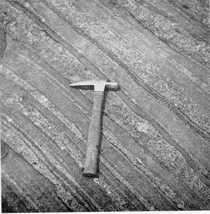
8 Kyanite in Dryden Township from a fraction of an inch to tens of feet. The different members probably represent original sedimentary beds. Within some bands (see photo below) there is a segregation of light and dark minerals into layers %-S inches thick, giving the gneiss a bedded appearance. The pink and grey gneiss, which makes up the greater portion of the rock unit, consists essentially of alternating pink and grey to dark grey layers that are ^/io to 3 or more inches thick. The width of the interbands ranges from a few inches to 100 feet or more. The wider bands of biotite-hornblende gneiss Pronounced banding in pink and grey gneisses, Wanapitei area. exhibit banding within the member as does the pink garnetiferous gneiss. The light-grey feldspar-quartz gneiss, and the muscovite-quartz gneiss, are both uniform, possessing only a faint gneissosity. However, they have a pronounced foliation parallel to the gneissosity. The impure quartzite occurs in bands and lenses whose widths range from a few inches to 2-3 feet, and it is often found in close association with kyanite-bearing bands. In general, the gneisses are fineto medium-grained and are composed essentially of three or more of quartz, feldspar, hornblende, biotite, muscovite, and garnet. Metadiabase The rock is fine- to medium-grained, massive, and weathers a dark reddishbrown with a rough pebbly surface. Diabasic texture is quite apparent in hand specimens. The minerals are feldspar, hornblende or pyroxene, and garnet. The garnet gives the rock its reddish-brown hue and occurs as fine granules intimately associated with the other minerals. 30
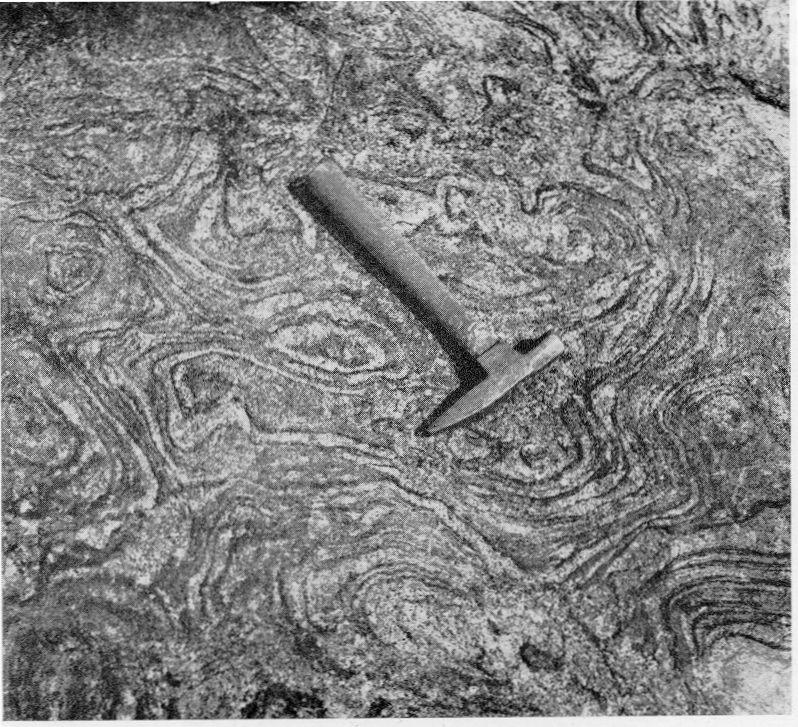
9 Pegmatite Geological Report No. 9 Pegmatite bodies occur in swarms and, most often, are parallel to the regional structure, gneissosity, and banding in the gneisses. They vary greatly in size, occurring as stringers and lenses of a fraction of an inch, as sills and dikes up to 60 feet across, and as irregular bodies up to 100 feet wide. There is a wide variation in grain size from a fraction of an inch up to a maximum of 6 inches; there is also a variation in grain size within individual pegmatite bodies. Highly contorted pink and grey gneiss, Wanapitei area. The division of pegmatite bodies into three main groups is based on the colour of the feldspar present in the rock. Some bodies are pink to salmon pink, others white to light-grey, and some blue-grey to grey. Megascopically, the pink pegmatites consist essentially of quartz and pink feldspar with sometimes a minor amount of white or grey feldspar, and the white pegmatites consist of white to grey feldspar. Both of the above types may or may not contain minor amounts of muscovite, biotite, and garnet. As a rule, the white pegmatites carry more biotite than the pink ones, and the pink pegmatites more muscovite than the white. In a few of the coarser-grained pegmatites, muscovite books up to 6 inches have been observed. A very few pegmatite bodies of the pinkfeldspar variety contain kyanite. Commonly the pink and,white types carry secondary mica that often appears as-a pale yellow-green waxy-looking material on the weathered surface. The grey variety is composed of blue-grey to grey feldspar, quartz, biotite, muscovite, garnet, and occasionally kyanite. Distinct zoning of minerals in the pegmatites as a whole is not common, but a few bodies have quartz-feldspar-mica zones with quartz-rich cores. 31
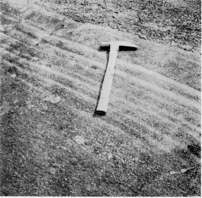
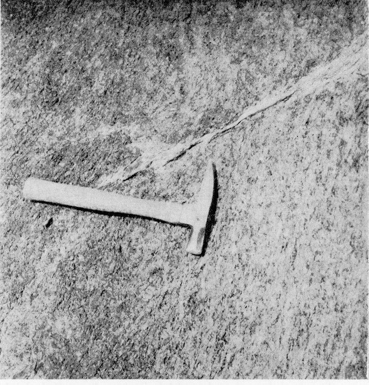
10 Kyanite in Dryden Township Kyanite Occurrences The kyanite occurrences in the Wanapitei area fall into four lithologic types: kyanite gneiss; kyanite-sillimanite gneiss; kyanite pegmatite; kyanite-bearing quartz veins. In addition to these four types, sillimanite occurs in lenses in the kyanitebearing gneisses, which are composed essentially of sillimanite and quartz. The only type of any possible economic importance is the kyanite gneiss. Kyanite Gneiss The kyanite gneiss is fairly widespread, as shown on map No The three bodies of possible economic value are located near highway No. 17 in lots 4 and 5, concession IV, Dryden township. Coarse-grained kyanite gneiss, Wanapitei area. The major constituents of the kyanite gneiss are quartz, feldspar, biotite, muscovite, garnet, and kyanite. The gneiss is generally coarse-grained (see photo above) with garnet porphyroblasts from a fraction of an inch up to 3 inches in diameter and kyanite blades from a fraction of an inch up to 3 inches in length. There is, however, an exception to this, in one instance observed by the author, where a coarse-grained kyanite-bearing band grades into a medium- to fine-grained kyanite gneiss as illustrated by the photo on page 33. In this case there is considerable field evidence indicating that the original sedimentary banding is coincident with the banding in the gneiss. This is quite clearly indicated in the photo. The kyanite gneiss occurs in bands and lenses varying from a fraction of an inch up to 450 feet wide and a few feet to ^ mile long. Some of the greater thicknesses may be partly due to intense folding and local faulting. The rock commonly weathers a distinctive reddish brown with the kyanite blades standing up in prominent relief above the other minerals. In many places aggregates of kyanite blades and rounded garnets have weathered out and accumulated in 32
11 Geological Report No. 9 Coarse-grained kyanite gneiss grading into fine-grained. Note sharp contact between the fine-grained part of the lower band and the coarse-grained section of the upper band at head of hammer. Wanapitei area. Garnetiferous band in kyanite gneiss. Note increase in size of garnets toward middle of band. Wanapitei area. 33
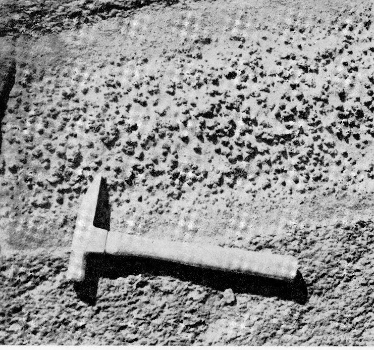
12 Kyanite in Dryden Township depressions on the weathered surface. Differential banding within the kyanitebearing bands is not apparent except for occasional bands or lenses of a highly garnetiferous-biotite gneiss varying from 6 inches to 2 feet in width (see photo, p. 33). These interbands do not carry kyanite and commonly are finer-grained at the contact where only a few small garnets are found; but there is an increase both in size and number of the garnets towards the interior of the bands. Sillimanite-bearing lenses from a fraction of an inch to more than l foot wide and l foot to more than 10 feet long have also developed along shears in the more massive kyanite gneiss. Folding and distortion of garnetiferous bands in kyanite gneiss, Wanapitei area. STRUCTURE OF THE KYANITE GNEISS Map No illustrates how the kyanite-bearing formations follow the regional structure, which in the central section is a large S-fold trending north east. The folding is more intense towards the fault along the railway, and here the noses of the folds are thickened and elongated, whereas the limbs are attenuated. The main occurrence lying north of the Canadian Pacific railway occupies the northeast limb and part of a nose of an anticline, which has been cut by the fault along the railway. The kyanite occurrences are frequently cut and offset by minor northeast faults, and minor folds and dragfolds are numerous in the kyanite gneiss. In the more massive bands, these folds are not always apparent owing to the lack of interbands and to the uniformity of the gneiss; but upon close observation they can be traced out by the foliation and the lineations in the rock. The accompanying photo illustrates the intense folding that has taken place within the kyanite gneiss. Lineation is strongly developed by the alignment of kyanite crystals generally plunging to the east and northeast in the plane of foliation. The foliation, along which the gneiss roughly breaks, is produced by the parallel alignment of the mica. Quartz and segregations of plagioclase and quartz are drawn out in lenses, which parallel the gneissosity. 34
13 Geological Report No. 9 MINERALOGY OF THE KYANITE GNEISS Microscopically, the kyanite gneiss has a granoblastic texture with a pro nounced alignment of kyanite in some sections but in others it shows less orien tation. Biotite and muscovite grains generally delineate the plane of foliation, and quartz and feldspar grains, to a lesser degree, are often elongated in the direction of foliation. Sixteen thin-sections from the kyanite gneiss at Wanapitei were examined to determine the mineral composition and percentages of each mineral present. All the thin-sections generally contained the same minerals but showed a wide variation in the proportions present. The kyanite gneiss consists essentially of Small sillimanite lens developed along small shear in kyanite gneiss. Wanapitei area. quartz, percent; plagioclase, 8-37; kyanite, 3-30; biotite, 6-29; garnet, 1-25; muscovite, 1-21; microcline, 0-7 percent; apatite, zircon, magnetite, and graphite are accessory minerals. Sillimanite is present in a very minor amount in two sections. The alteration products are chiefly sericite and muscovite, epi dote, and rarely chlorite. The kyanite occ urs as blades ranging in length from ^ to 4 inches, and from 3le to ^ inch in width. Grain size may vary from band to band, or within the same band. It may be blue, green, grey, or colourless; the blue variety is most common. Occasionally in some blades, the middle or some other part is blue, and the margin or remainder is white. In the coarser-grained gneiss, the kyanite blades have a pronounced lineation generally plunging steeply to the northeast or east. SILLIMANITE LENSES IN THE KYANITE GNEISS The accompanying photograph illustrates how sillimanite lenses occur in the kyanite gneiss. They appear to be located in zones where there is evidence of shearing. Within the sillimanite occurrences, small dragfolds are observed 35

14 Kyanite in Dryden Township both megascopically and microscopically. The sillimanite is of the fibrolite variety that, in hand specimens, has a silky lustre and is pale-brown to greyishwhite. Microscopically, the sillimanite is intimately associated with quartz and occurs as subparallel aggregates of fine needles. Generally the quartz grains are elongated. Kyanite-Sillimanite Gneiss The kyanite-sillimanite gneiss is not found in the area of the main kyanite occurrence, but does occur 1^ miles on a bearing N.600E. from the bridge in Wanapitei village. The band in which this gneiss occurs is about feet long and up to 100 feet wide and strikes in an east-northeasterly direction. The neighbouring rocks immediately north of it are garnet amphibolite and pink and grey gneiss, and south of it, pink gneiss and hornblende amphibolite. The kyanite-sillimanite gneiss, which is medium-grained with garnet porphyroblasts up to ^ inch in diameter, weathers a reddish-brown with a felty surface. The megascopic minerals are sillimanite, garnet, biotite, muscovite, quartz, and feldspar. Kyanite Pegmatite Kyanite pegmatites are not numerous in the Dryden area. Those that are present are not economically important, but the mode of their occurrence is of geological interest. They are located mainly in two localities, the one in the kyanite occurrence north of the railway and the other about 3,400 feet east and 500 feet south of the bridge in Wanapitei village. These pegmatites occur as dikes, as sills, and as irregular and lens-like bodies. Grain size ranges from a fraction of an inch up to 4 inches in these occurrences. The kyanite pegmatites can be divided into two groups: those that occur within the kyanite gneiss, and those found within non-kyanite-bearing rocks near kyanite occurrences. The main megascopic difference between the two is that the former contains grey to bluish-grey feldspar whereas the latter are chiefly pink. Further, the grey pegmatites contain biotite rather than musco vite, which is the chief mica in the pink pegmatites. Kyanite-Bearing Quartz Veins Kyanite-bearing quartz veins and lenses are rare in this area. They occur always within the kyanite gneiss usually parallel to, but in one instance cutting across, gneissosity. The veins and lenses are never over J^ inch wide and a few feet long. The kyanite crystals, which have a beautiful sky-blue colour, range from 3^ to 4 inches in length and show no lineation or directional orientation. Economic Geology The commercial possibilities of the kyanite deposits of Dryden township are stated in the following report on Northern Kyanite Mines Limited. This is the only company that, to date, has attempted to develop these deposits. Northern Kyanite Mines Limited Hoyle Mining Company Limited staked the kyanite deposits in 1952 and later formed a subsidiary company, Northern Kyanite Mines Limited, to take over the property. In 1958, Northern Kyanite Mines Limited owned 43 claims, totalling 1,720 acres, in lots 4, 5, 6 and 7, concession IV, and lot 7, concession III, Dryden township. In the first annual report of the company, covering the period April 1955 to December 1957, M. J. Tamplin, the company's metallurgical engineer, re viewed the exploration, development, and research activities of the company. 36

15 Geological Report No. 9 Showings A and C mentioned in the company report are marked "A Showing" and "C Showing" on Map No (in map case). Part of the company report follows: Exploration and Development In 1953, two trenches were cut, and bulk samples were sent to Lakefield Research Limited, Lakefield, Ontario. Returns were: from a 35ft. trench on Showing "A" north of the C.P. R. tracks, 15*^ kyanite; from a 100 ft. trench on Showing "C" south of #17 Highway, 25% kyanite. Pioneer Consultants Limited of Haileybury, Ontario, were engaged to carry out the assess ment work on the claims. 10,214 feet of diamond drilling were done, and at the same time some 20 tons of bulk samples made available for test work from the trench on Showing "C". On completion of all prescribed assessment work, Pioneer Consultants Limited submitted a report in March Because Showing "C" appeared on outcrop to contain the major deposit, and was moreover in the best location for initial quarrying operations, as much as possible of the drilling was done at this location. From this work it was calculated by Pioneer Consultants Limited that 1,965,394 tons of ore, grading IS.27% kyanite were indicated in a length of 2,000 feet on Showing "C" to a depth of 100 feet over an average width of 140 feet. Bottom of the deposit was not ascertained, several holes being stopped at 180 feet still in kyanite gneiss. Research in Processing The first research problem encountered was discovery of an accurate method of determining kyanite content. A mineral examination procedure first outlined by Mr. E. O. Foster of Lake field Research Limited, was later developed and refined in the analytical laboratories of the Industrial Minerals Division, Department of Mines and Technical Surveys, Ottawa. It should be noted that, in the final calculations of grade made by Pioneer Consultants Limited, the assays used were those returned from this improved method. From the first bulk samples, Lakefield Research Limited obtained concentrates containing 90%-92%. kyanite by a combination of jigging, flotation, and magnetic separation. About 2 tons were produced and distributed to consumers in the search for market outlets. The Industrial Minerals Division of the Department of Mines and Technical Surveys, Ottawa, initiated a project to discover methods of recovering kyanite from Canadian ores, and Northern Kyanite Mines Limited has collaborated by supplying all ore for the work. Both wet and dry ore dressing flowsheets have been developed, and work is still in progress to establish the preferred method. Concentrates of a quality superior to any in North America have been obtained at attractive recoveries. The work also has indicated that garnet of com mercial quality may also prove to be recoverable. The Ceramic Engineers of the Department have been successful in developing and patenting a new process for stabilizing kyanite concentrates, and producing a mullite aggregate with refrac tory properties superior to any imported kyanite, and the equal of many synthetic products. Northern Kyanite Mines Limited are collaborating in tests of this process under semi-commercial conditions, and will have use of the (Crown owned) patented features at a nominal fee. Research in Marketing Freight rates to United States consuming points were an adverse competitive factor in initial attempts to sell kyanite concentrates. However, the superior quality of Canadian concentrates is now bringing offers of premium prices that could provide sufficient incentive for selling concen trates in the U.S.A. With the freight rates now prevailing to Europe, mullite aggregate produced by the Ottawa process can compete pricewise with present imports from India and Africa. Again on the basis of superior quality, a strong interest is developing in our Canadian source of this material Work Work now being carried over into 1958 consists of the production of several hundred pounds of both concentrates and aggregate under conditions that can be duplicated in commercial practice. This material should be in the hands of interested consumers in Europe and the U.S.A. some time in May, The reception accorded this material will enable Northern Kyanite Mines Limited to assess the incentive for initiation of production plans. Bibliography Barlow, A. E. 1897: Report on the geology and natural resources of the area included by the Nipissing and Temiscaming map sheets; Geol. Surv. Canada, Vol. X, rept. No. 1. Coleman, A. P. 1914: The Pre-Cambrian rocks north of Lake Huron, with special reference to the Sudbury Series; Ontario. Bur. Mines, Vol. XXIII, pt. 1. Hewitt, D. F. 1952: Kyanite and sillimanite in Ontario; Ontario Dept. Mines, Indust. mineral circ. No. 4, Nov
16
17 INDEX Access - Acknowledgments Alice Lake - Alteration, rock Amphibolite - From gabbro From sediments Analyses, rock - Arcadia Nickel Corp. B Baby Lake - Banded rocks Amphibolite Gneiss - photos - Basic intrusives See also Gabbro. Bibliography - Bowie, Glenn - Breccia - Intrusion, notes and photo Broder tp., rocks - Brucite - A C Carson, W. E. Chalcopyrite - See also Copper. Chubb, F. - Conglomerate - Coniston - Coniston Series - Contorted gneiss, photos Copper - Copper Cliff Rhyolite, age Creighton fault - Cryderman, J. R. - D Daisy Lake - Diabase - Dill tp. Rocks - photo - Dryden tp. Kyanite occurrences, map report on Nickel-copper Rocks - gabbro - gneiss, injection - pegmatite structure - 2, 26 Falcon fault Faulting Feldspathization, notes and - 10, 11, 22 photos , Fk Flowage, rock Contorted gneiss, photos 12, 31-9, 28, 29 Fo Iding - 17, 18, 21 8 In kyanite gneiss, notes and photo Formations, tables of , 28 Foster, E. O , 18 r Oa bbro - 7 Analysis 8 Metamorphism, notes and photo Sulphides in , 22 \ O, 7 l tja Garnet, commercial - 37 /~- Lra Garnetiferous rocks 28, , 29, 32, 34 12, 30, 33 ^ 23, 37 Amphibolite , 29-3, 16 Kyanite gneiss, notes and photos Schists , 16 Geology, G economic - 22, ' U Ce 6, 16 ^ Geology, general , Geology, structural , SGneisses , 28 Banded , 13, Kyanite in ? g' Gossan , 22 ii (jrr /~j Or Granitic gneiss , 29 *' 27 f.- Gr Granitization , , 15 Grant, J. A l, 3, 22 20, 26 or Grenville front , 17, rr Topography, air photo - - frontis. - 12, 31 Gr Greywacke , H 20 Hewitt, D. F He Hornblende gneiss - 29 He Hoyle Mining Co. Ltd. 28, 36 Hi Huronian rocks, age , 19 I - 5, 12, 16 Injection gneiss , 13 Intrusion breccia , 11-9, 12, 13 ft Intrusives , 7, 13, See also Gabbro; Pegmatite. - in map case K 22 Keweenawan rocks - - 7, 8, 10, 11 12, 13-13, 31, 36 Economic geology - 22, 36 4, 28 Killarnean rocks - Contact, Sudbury Group Lithology and photos Metamorphism, age of - 17, 18, 20 Kyanite K} Dryden tp., report on Ore dressing - Uses - Kyanite gneiss , , , 28,
18 Index Laminated quartzite Lime-silicate rocks Limestone - Loughrin tp. - M MacGregor, L D. - Maki, O. - Map, geological, coloured Map, geological, sketch Me Kim Greywacke Mcvittie, A. E. - Mcvittie, J. P. Metadiabase - Metagabbro - Metamorphic Group - Lithology and photos Metamorphism - Mineralogy, kyanite gneiss Moonlight Beach fault Mullite - Murray fault - N Neelon tp. Air photo - Kyanite - Nickel-copper - Rocks - structure - Nickel - Nipissing diabase - Norite, analysis Northern Kyanite Mines Ltd. Property, report on Olivine diabase O 14, 15-13, 14-6, 13, in map case 11-6, 7, , 10, , , frontis , 6, 8, , Q Quartz-feldspar gneiss Quartz veins, kyanite in Quartzite - Feldspathized - Flowage in - Laminated Photos - R Raft Lake - Ramsay Lake Conglomerate Correlation Ramsey Lake - Richard Lake Schists, garnetiferous Sedimentary rocks Metamorphism See also Quartzite. Sillimanite - Staurolite - Stratigraphy - Street tp. - Sudbury Group. Age - Contact, Killarnean Correlation Feldspathization - Lithology - Sulphides - T Tamplin, M. J. Terminology Thomson, Jas. E. - Topography Air photo showing Tuc Metals Ltd. Tuffs , , 15 14, 16, , 15 6, 7-18, , 14, 22 32, 35, , , , l, 3, 23-3, 27 frontis Paragneiss - Pearson, W. J. Pegmatite - Kyanite in Permeation gneiss Phemister, T. C. - Pioneer Consultants Ltd. - Pleistocene - Precambrian rocks Pre-Huronian. See Sudbury Group. Pyrrhotite - 9 l, 3, 25-13, l, 3, , Uranium - U W Wanapitei area. Kyanite, report on - Wanapitei fault Air photo - Description and photo Wanapitei Quartzite See also Quartzite. Wanapitei River Worthington fault , 16 frontis. - 18, 19 6, 7, , 19 2,000 l96z 3339rp 40
19
20

21
22
23

24
25

26 Map 2021 Dryden Kyanite ONTARIO DEPARTMENT OF MINES HON. G. C. WARDROPE, Minister of Mines D. P. Douglass, Deputy Minister M. E. Hurst, Director, Geological Branch Scale l inch to 50 miles LEGEND CENOZOIC RECENT AND PLEISTOCENE Sand, grave! and day. SYMBOLS GREAT UNCONFORMITY PRECAMBRIAN Motor road. KILL.ARNEAN Trail. Pegmatite (pink, white, grey). Lot and concession lines, approximate position only. Metadiabase. INTRUSIVE CONTACT Glacial striae. METAMORPHIC GROUP Pink and grey gneisses interbanded with hornblende and biotite gneiss, quartzfeldspar gneiss, quartz-muscovite gneiss, leucocratic garnetiferous gneiss, impure quart z rite. Boundary of rock outcrop. Geological boundary, defined. Pink granitic gneiss. Geological boundary, approximate. Amphibolites* and hornblende gneiss. Strike and dip of bed, direction of top unknown. Garnet amphibolite. Strike and vertical dip, direction of top unknown. Kyanite gneiss. Strike and dip of gneissosity. Strike of vertical gneissosity. FAULTED CONTACT PRE-HURONIAN Strike and dip of schistosity. SUDBURY GROUP Wan api fei quartzite. Drag-folds(shapeand direction of plunge known). Lineation (plunge known, unknown). Fault, assumed. Building. Trench. Shear zone. SOURCES OF INFORMATION A showing Showing mentioned in report. Geology and base map by W. J. Pearson Published 1962 Map 2O21 Kyanite occurrences in parts of DRYDEN TOWNSHIP, Lots 3-7, Cons. III-IV DISTRICT OF SUDBURY Scale 1:7920 or l Inch to 10 Chains
AGGREGATE RESOURCES OF ONTARIO (ARO) METADATA
 METADATA") AGGREGATE RESOURCES OF ONTARIO (ARO) METADATA GENERAL INFORMATION Official Name of the Data Set or Information Holding: Aggregate Resources of Ontario Acronyms are Used to Identify the Data Set or Information
AGGREGATE RESOURCES OF ONTARIO (ARO) METADATA GENERAL INFORMATION Official Name of the Data Set or Information Holding: Aggregate Resources of Ontario Acronyms are Used to Identify the Data Set or Information
THESE TERMS GOVERN YOUR USE OF THIS DOCUMENT
 THESE TERMS GOVERN YOUR USE OF THIS DOCUMENT Your use of this Ontario Geological Survey document (the Content ) is governed by the terms set out on this page ( Terms of Use ). By downloading this Content,
Nickel Division - Sudbury Operations
 * *-.. FALCONBRIDGE NICKEL MINES LIMITED Nickel Division - Sudbury Operations Falconbridge, Ontario 002261 GRAHAM 010 GEOLOGY OF TllE NORTH QUARTER OP LOT 2, CON. IV, GRAHAM TOWNSHIP, DISTRICT OP SUDBURY,
Local: (705) Toll Free: , ext (inside Canada, United States) Local: (705) Toll Free: , ext.
 Toll Free: , ext (inside Canada, United States) Local: (705) Toll Free: , ext.") THESE TERMS GOVERN YOUR USE OF THIS DOCUMENT Your use of this Ontario Geological Survey document (the Content ) is governed by the terms set out on this page ( Terms of Use ). By downloading this Content,
THESE TERMS GOVERN YOUR USE OF THIS DOCUMENT Your use of this Ontario Geological Survey document (the Content ) is governed by the terms set out on this page ( Terms of Use ). By downloading this Content,
MRD 228 METADATA. Official Name of the Data Set or Information Holding: Physiography of Southern Ontario
 MRD 228 METADATA GENERAL INFORMATION Official Name of the Data Set or Information Holding: Physiography of Southern Ontario Acronyms are Used to Identify the Data Set or Information Holding: MRD228 Describe
Local: (705) Toll Free: , ext (inside Canada, United States) Local: (705) Toll Free: , ext.
 Toll Free: , ext (inside Canada, United States) Local: (705) Toll Free: , ext.") THESE TERMS GOVERN YOUR USE OF THIS DOCUMENT Your use of this Ontario Geological Survey document (the Content ) is governed by the terms set out on this page ( Terms of Use ). By downloading this Content,
THESE TERMS GOVERN YOUR USE OF THIS DOCUMENT Your use of this Ontario Geological Survey document (the Content ) is governed by the terms set out on this page ( Terms of Use ). By downloading this Content,
MRD 281. Official Name of the Data Set or Information Holding: Northeastern Ontario Rhyolite Database
 MRD 281 GENERAL INFORMATION Official Name of the Data Set or Information Holding: Northeastern Ontario Rhyolite Database Acronyms are Used to Identify the Data Set or Information Holding: MRD281 Describe
THESE TERMS GOVERN YOUR USE OF THIS DOCUMENT
 THESE TERMS GOVERN YOUR USE OF THIS DOCUMENT Your use of this Ontario Geological Survey document (the Content ) is governed by the terms set out on this page ( Terms of Use ). By downloading this Content,
GEOPHYSICAL DATA SET (GDS) 1084B METADATA
 1084B METADATA") GEOPHYSICAL DATA SET (GDS) 1084B METADATA GENERAL INFORMATION Official Name of the Data Set or Information Holding: Ontario Airborne Geophysical Surveys, Magnetic Gradiometer and Gamma-Ray Spectrometric
GEOPHYSICAL DATA SET (GDS) 1084B METADATA GENERAL INFORMATION Official Name of the Data Set or Information Holding: Ontario Airborne Geophysical Surveys, Magnetic Gradiometer and Gamma-Ray Spectrometric
We are committed to providing accessible customer service. If you need accessible formats or communications supports, please contact us.
 We are committed to providing accessible customer service. If you need accessible formats or communications supports, please contact us. Nous tenons à améliorer l accessibilité des services à la clientèle.
MRD273-REV METADATA. Acronyms are Used to Identify the Data Set or Information Holding: MRD273-REV
 MRD273-REV METADATA GENERAL INFORMATION Official Name of the Data Set or Information Holding: Ontario Precambrian Bedrock Magnetic Susceptibility Geodatabase for 2001 to 2012 Acronyms are Used to Identify
MRD283-REV METADATA. Acronyms are Used to Identify the Data Set or Information Holding: MRD283-REV
 MRD283-REV METADATA GENERAL INFORMATION Official Name of the Data Set or Information Holding: Ambient Groundwater Geochemistry Data for Southern Ontario, 2007 2014 Acronyms are Used to Identify the Data
CHAPTER 3.3: METAMORPHIC ROCKS
 CHAPTER 3.3: METAMORPHIC ROCKS Introduction Metamorphism - the process of changes in texture and mineralogy of pre-existing rock due to changes in temperature and/or pressure. Metamorphic means change
We are committed to providing accessible customer service. If you need accessible formats or communications supports, please contact us.
 We are committed to providing accessible customer service. If you need accessible formats or communications supports, please contact us. Nous tenons à améliorer l accessibilité des services à la clientèle.
Namex Explorations Inc. Report on Drill Holes PC & PC Post Creek Property Claim S.l , Norman Township Sudbury Mining District
 . 368 4: Namex Explorations nc. Report on Drill Holes PC - 12-06 & PC -- 13-06 Post Creek Property Claim S.l 094826, Norman Township Sudbury Mining District RECEVED DEC 1 0 =:~7 ntroduction GEOSCENCf ASSESSMENT
Report. Mining Claim SO Butt Township. District of Nipissing. Southern Ontario Mining District. Richard Keevil ~ Geologist. August 29,2006.
 Report On Mining Claim SO 1077365 Butt Township District of Nipissing Southern Ontario Mining District ~ "'_I ""'..1 D I..:"'.U&O... ~u ~]. Richard Keevil ~ Geologist August 29,2006. Richard R. Keevil,
MRD 207 METADATA DETAIL PAGE
 MRD 207 METADATA DETAIL PAGE The following represents the Basic description of an information holding. To obtain more information about this holding, see the section named Contacts. GENERAL INFORMATION
THESE TERMS GOVERN YOUR USE OF THIS DOCUMENT
 THESE TERMS GOVERN YOUR USE OF THIS DOCUMENT Your use of this Ontario Geological Survey document (the Content ) is governed by the terms set out on this page ( Terms of Use ). By downloading this Content,
MRD 229-Revised METADATA
 GENERAL INFORMATION MRD 229-Revised METADATA Official Name of the Data Set or Information Holding: Till Compositional Database: Investigation of the Overburden Signature of the Caribou Lake Greenstone
Practice Test Rocks and Minerals. Name. Page 1
 Name Practice Test Rocks and Minerals 1. Which rock would be the best source of the mineral garnet? A) basalt B) limestone C) schist D) slate 2. Which mineral is mined for its iron content? A) hematite
GEOLOGY OF THE NICOLA GROUP BETWEEN MISSEZULA LAKE AND ALLISON LAKE
 GEOLOGY OF THE NICOLA GROUP BETWEEN MISSEZULA LAKE AND ALLISON LAKE (92H/15E. 10E1 By V. A. Preto INTRODUCTION Mapping was continued southward from the area covered in 1973 and an additional 55 square
Introducti on. Land Survey. Geomagnetic Survey. Geomagnetic Results and Interpretati ons - Conclusions and Recommendations C
 m M 42A86SW8281 63.42 PRICE 010 C O H T E H l 42A86SW828I 63.42 PRICE 010C Introducti on Land Survey Geomagnetic Survey Geomagnetic Results and Interpretati ons - Conclusions and Recommendations - - -
Igneous Rocks. Sedimentary Rocks. Metamorphic Rocks
 Name: Date: Igneous Rocks Igneous rocks form from the solidification of magma either below (intrusive igneous rocks) or above (extrusive igneous rocks) the Earth s surface. For example, the igneous rock
Local: (705) Toll Free: , ext (inside Canada, United States) Local: (705) Toll Free: , ext.
 Toll Free: , ext (inside Canada, United States) Local: (705) Toll Free: , ext.") THESE TERMS GOVERN YOUR USE OF THIS DOCUMENT Your use of this Ontario Geological Survey document (the Content ) is governed by the terms set out on this page ( Terms of Use ). By downloading this Content,
THESE TERMS GOVERN YOUR USE OF THIS DOCUMENT Your use of this Ontario Geological Survey document (the Content ) is governed by the terms set out on this page ( Terms of Use ). By downloading this Content,
Geology, Alteration and. Petrogenesis
 The Mutooroo Copper Deposit: Geology, Alteration and Petrogenesis Graham S. Teale Consultant t Andrew T. Price Havilah Resources NL The speaker would like to thank Havilah Resources NL for the opportunity
Big Island Field Trip
 Big Island Field Trip Space Still Available Group Airline Tickets May be available if enough people sign on If interested send email to Greg Ravizza Planning Meeting Next Week Will
GEOLOGY OF THAILAND (METAMORPHIC ROCKS)
") GEOLOGY OF THAILAND (METAMORPHIC ROCKS) High-Grade Metamorphic Rocks (Precambrian?) Low-Grade Metamorphic Rocks (Lower Paleozoic) 1 THAILAND EXPLANATION Lower Paleozoic Rocks (Low Grade) Precambrian (?)
GEOLOGY OF THAILAND (METAMORPHIC ROCKS) High-Grade Metamorphic Rocks (Precambrian?) Low-Grade Metamorphic Rocks (Lower Paleozoic) 1 THAILAND EXPLANATION Lower Paleozoic Rocks (Low Grade) Precambrian (?)
THESE TERMS GOVERN YOUR USE OF THIS DOCUMENT
 THESE TERMS GOVERN YOUR USE OF THIS DOCUMENT Your use of this Ontario Geological Survey document (the Content ) is governed by the terms set out on this page ( Terms of Use ). By downloading this Content,
Appendix 11. Geology. of the. I60 area
 Appendix 11 Geology of the I60 area 1. Locality The locality of the I60 area is as follows; Northwestern corner; UTM_EW 530513, UTM_NS 7345741 Southwestern corner; UTM_EW 530418, UTM_NS 7301454 Northeastern
THESE TERMS GOVERN YOUR USE OF THIS DOCUMENT
 THESE TERMS GOVERN YOUR USE OF THIS DOCUMENT Your use of this Ontario Geological Survey document (the Content ) is governed by the terms set out on this page ( Terms of Use ). By downloading this Content,
The MAPLE BAY PROJECT Copper Silver - Gold
 The MAPLE BAY PROJECT Copper Silver - Gold Good grade and tonnage potential within close proximity to Tidewater The Maple Bay Copper Silver Gold Project covers highly favourable geological host rocks of
Local: (705) Toll Free: , ext (inside Canada, United States) Local: (705) Toll Free: , ext.
 Toll Free: , ext (inside Canada, United States) Local: (705) Toll Free: , ext.") THESE TERMS GOVERN YOUR USE OF THIS DOCUMENT Your use of this Ontario Geological Survey document (the Content ) is governed by the terms set out on this page ( Terms of Use ). By downloading this Content,
THESE TERMS GOVERN YOUR USE OF THIS DOCUMENT Your use of this Ontario Geological Survey document (the Content ) is governed by the terms set out on this page ( Terms of Use ). By downloading this Content,
MEMO. TO: Dennis Lapoint CC: FROM: Eriaan Wirosono DATE: April, 20 th 2014 SUBJECT: Exploration activity report March-April 2014_EW
 TO: Dennis Lapoint CC: FROM: Eriaan Wirosono DATE: April, 20 th 2014 SUBJECT: Exploration activity report March-April 2014_EW MEMO 1. Highlights and Productivity Overview pan sampling on target Areas 1
THESE TERMS GOVERN YOUR USE OF THIS DOCUMENT
 THESE TERMS GOVERN YOUR USE OF THIS DOCUMENT Your use of this Ontario Geological Survey document (the Content ) is governed by the terms set out on this page ( Terms of Use ). By downloading this Content,
Introduction to Geology Spring 2008
 MIT OpenCourseWare http://ocw.mit.edu 12.001 Introduction to Geology Spring 2008 For information about citing these materials or our Terms of Use, visit: http://ocw.mit.edu/terms. Regional metamorphism
EESC 4701: Igneous and Metamorphic Petrology METAMORPHIC ROCKS LAB 8 HANDOUT
 Sources: Caltech, Cornell, UCSC, TAMIU Introduction EESC 4701: Igneous and Metamorphic Petrology METAMORPHIC ROCKS LAB 8 HANDOUT Metamorphism is the process by which physical and chemical changes in a
RR#7 - Multiple Choice
 1. Which mineral is mined for its iron content? 1) hematite 2) fluorite 3) galena 4) talc 2. Which rock is composed of the mineral halite that formed when seawater evaporated? 1) limestone 2) dolostone
Version 1 Page 1 Barnard/George/Ward
 The Great Mineral & Rock Test 1. Base your answer to the following question on the table below which provides information about the crystal sizes and the mineral compositions of four igneous rocks, A,
Local: (705) Toll Free: , ext (inside Canada, United States) Local: (705) Toll Free: , ext.
 Toll Free: , ext (inside Canada, United States) Local: (705) Toll Free: , ext.") THESE TERMS GOVERN YOUR USE OF THIS DOCUMENT Your use of this Ontario Geological Survey document (the Content ) is governed by the terms set out on this page ( Terms of Use ). By downloading this Content,
THESE TERMS GOVERN YOUR USE OF THIS DOCUMENT Your use of this Ontario Geological Survey document (the Content ) is governed by the terms set out on this page ( Terms of Use ). By downloading this Content,
DISCOVERY OF MINERALISED PORPHYRY & MAGNETITE-COPPER-GOLD AT KAMARANGAN
 MEDUSA MINING LIMITED ABN: 60 099 377 849 Unit 7, 11 Preston Street Como WA 6152 PO Box 860 Canning Bridge WA 6153 Telephone: +618-9367 0601 Facsimile: +618-9367 0602 Email: admin@medusamining.com.au Internet:
Lab: Metamorphism: minerals, rocks and plate tectonics!
 Introduction The Earth s crust is in a constant state of change. For example, plutonic igneous rocks are exposed at the surface through uplift and erosion. Many minerals within igneous rocks are unstable
THESE TERMS GOVERN YOUR USE OF THIS DOCUMENT
 THESE TERMS GOVERN YOUR USE OF THIS DOCUMENT Your use of this Ontario Geological Survey document (the Content ) is governed by the terms set out on this page ( Terms of Use ). By downloading this Content,
BUREAU OF MINERAL RESOURCES GEOLOGY AND GEOPHYSICS,
 ^ ^c ^ / o/./ 3 4f c,3 COMMONWEALTH OF AUSTRALIA. DEPARTMENT OF NATIONAL DEVELOPMENT. BUREAU OF MINERAL RESOURCES GEOLOGY AND GEOPHYSICS, RECORDS. 1 960/134 GEOLOGY OF THE MAVIS TIN LEASE by P.G. Dunn.
Geological Mapping and Mineralization on the eastern part of the Mumford Claim Cardiff Township, Ontario
 Geological Mapping and Mineralization on the eastern part of the Mumford Claim Cardiff Township, Ontario SO 1500016 (Lots 9-11, Concession 22 and Lot 11, Concession 21)), By Bradley S Wilson Kingston,
Prof. Tejas S Patil Dept Of Geology M.J.College.
 Prof. Tejas S Patil Dept Of Geology M.J.College. Metamorphic rocks When rocks are baked by heat of molten magma or squeezed by the movements of huge tectonic plates or by the pressure of overlying thick
APPENDIX 2 Table 2. Sample descriptions
 Table 2. descriptions 225 Felsic gneiss, fine-grained and very light-gray. From the upper part of the lower of the two layers, which connect. 226 Amphibolite, even-grained, fine-grained, medium-gray, little
2013 GEOLOGICAL ASSESSMENT REPORT SHERIDAN HILL PROPERTY
 2013 GEOLOGICAL ASSESSMENT REPORT ON THE SHERIDAN HILL PROPERTY NEW WESTMINSTER MINING DIVISION BRITISH COLUMBIA NTS 092G07 49 16 31 NORTH LATITUDE, 122 39 48 WEST LONGITUDE PREPARED FOR Sheridan Hill
Lab 6: Metamorphic Rocks
 Introduction The Earth s crust is in a constant state of change. For example, plutonic igneous rocks are exposed at the surface through uplift and erosion. Many minerals within igneous rocks are unstable
THESE TERMS GOVERN YOUR USE OF THIS DOCUMENT
 THESE TERMS GOVERN YOUR USE OF THIS DOCUMENT Your use of this Ontario Geological Survey document (the Content ) is governed by the terms set out on this page ( Terms of Use ). By downloading this Content,
As compaction and cementation of these sediments eventually occur, which area will become siltstone? A) A B) B C) C D) D
 A B) B C) C D) D") 1. A student obtains a cup of quartz sand from a beach. A saltwater solution is poured into the sand and allowed to evaporate. The mineral residue from the saltwater solution cements the sand grains together,
1. A student obtains a cup of quartz sand from a beach. A saltwater solution is poured into the sand and allowed to evaporate. The mineral residue from the saltwater solution cements the sand grains together,
Norlex Mines Property. Whitefish Bay Area, Kenora District. The property of Norlex Mines under option to Canadian Javelin
 52E09SW0025 63.2231 WHITEFISH BAY AND MA Norlex Mines Property D: KENORA 010 D. SEP 14-1967 RECEIPT No. MINING DIVISION Whitefish Bay Area, Kenora District. '; Introduction The property of Norlex Mines
ZONED PEGMATITES OF THE MICANITE DISTRICT FREMONT & PARK COUNTIES, COLORADO
 ZONED PEGMATITES OF THE MICANITE DISTRICT FREMONT & PARK COUNTIES, COLORADO By Andy Weinzapfel INTRODUCTION The below article is based on library research and field work conducted during 2007. The Micanite
Review - Unit 2 - Rocks and Minerals
 Review - Unit 2 - Rocks and Minerals Base your answers to questions 1 and 2 on the diagram below, which shows the results of three different physical tests, A, B, and C, that were performed on a mineral.
GEOL FORENSIC GEOLOGY ROCK IDENTIFICATION
 GEOL.2150 - FORENSIC GEOLOGY ROCK IDENTIFICATION Name I. Introduction There are three basic types of rocks - igneous, sedimentary, and metamorphic: Igneous. Igneous rocks have solidified from molten matter
RE~ORT ON. J.F.V. MILLAR, P. Eng. GEOCHEMICAL SURVEY TIMBASKET AND MOGUL MINERAL CLAIMS. Kinbasket Lake, B. C. 51 degrees 118 degrees N.E.
 RE~ORT ON GEOCHEMICAL SURVEY TIMBASKET AND MOGUL MINERAL CLAIMS Kinbasket Lake, B. C. 51 degrees 118 degrees N.E. J.F.V. MILLAR, P. Eng. Lease held by J.F.V. MILLAR Work done Sept. 22 - Oct. 3, 1967. REPORT
Supplementary Table 1.
 Supplementary Table 1. Compositional groups, typical sample numbers and location with their bulk compositional, mineralogical and petrographic characteristics at different metamorphic grades. Metamorphic
Pahtavaara Drill Program Intersects 32.8 G/T Gold Over 2.0M And 2.1 G/T Gold Over 18.0M In The Karoliina Zone
 Page 1 of 6 a Pahtavaara Drill Program Intersects 32.8 G/T Gold Over 2.0M And 2.1 G/T Gold Over 18.0M In The Karoliina Zone Jan 11, 2017 Toronto, Ontario, Canada Listed: RUP-TSX-V January 10, 2017 Rupert
Summary of Rover Metals Geologic Mapping Program at the Up Town Gold Project, Northwest Territories
 October 13, 2017 Summary of Rover Metals Geologic Mapping Program at the Up Town Gold Project, Northwest Territories Vancouver, British Columbia, Canada - Rover Metals Corp., Rover, is pleased to provide
=%REPORT RECONNAISSANCE OF CHISHOLM LAKE PROSPECT. October 25, 1977
 =%REPORT ON FIELD RECONNAISSANCE OF CHISHOLM LAKE PROSPECT October 25, 1977 Bruce D. Vincent Imperial Oil Limited, Minerals - Coal, CALGARY, ALBERTA CHISHOLM LAKE PROSPECT Introduction The Chisholm Lake
THESE TERMS GOVERN YOUR USE OF THIS DOCUMENT
 THESE TERMS GOVERN YOUR USE OF THIS DOCUMENT ISBN 978-1-4606-4599-4 (DVD) ISBN 978-1-4606-4598-7 (zip file) Your use of this electronic information product ( EIP ), and the digital data files contained
Page 1. Name: 1) Which diagram best shows the grain size of some common sedimentary rocks?
 Which diagram best shows the grain size of some common sedimentary rocks?") Name: 1) Which diagram best shows the grain size of some common sedimentary rocks? 1663-1 - Page 1 5) The flowchart below illustrates the change from melted rock to basalt. 2) Which processes most likely
Name: 1) Which diagram best shows the grain size of some common sedimentary rocks? 1663-1 - Page 1 5) The flowchart below illustrates the change from melted rock to basalt. 2) Which processes most likely
Marshall Shore Town Park, Liberty, Maine
 Maine Geologic Facts and Localities August, 2005 Marshall Shore Town Park, Liberty, Maine 44 22 33.04 N, 69 21 9.19 W Text by Henry N. Berry IV, Department of Agriculture, Conservation & Forestry 1 Introduction
42H88SW NEWMAN
 42H88SW0003 63.8199 NEWMAN 010 TRIPOINT MINES LIMITED, Suite 305-100 Adelaide St. West, Toronto l, Ontario. Gentlemen: Your Company recently conducted a combined magneticelectromagnetic survey over a ten
BUREAU OF MINERAL RESOURCES GEOLOGY AND GEOPHYSICS.
 COMMONWEALTH OF AUSTRALIA. DEPARTMENT OF NATIONAL DEVELOPMENT. BUREAU OF MINERAL RESOURCES GEOLOGY AND GEOPHYSICS. RECORDS: 1962/33 GEOLOGY OF THE B.W. IRON CLAIM, HUNDRED OF WATERHOUSE, NORTHERN TERRITORY.
THESE TERMS GOVERN YOUR USE OF THIS DOCUMENT
 THESE TERMS GOVERN YOUR USE OF THIS DOCUMENT Your use of this Ontario Geological Survey document (the Content ) is governed by the terms set out on this page ( Terms of Use ). By downloading this Content,
Local: (705) Toll Free: , ext (inside Canada, United States) Local: (705) Toll Free: , ext.
 Toll Free: , ext (inside Canada, United States) Local: (705) Toll Free: , ext.") THESE TERMS GOVERN YOUR USE OF THIS DOCUMENT Your use of this Ontario Geological Survey document (the Content ) is governed by the terms set out on this page ( Terms of Use ). By downloading this Content,
THESE TERMS GOVERN YOUR USE OF THIS DOCUMENT Your use of this Ontario Geological Survey document (the Content ) is governed by the terms set out on this page ( Terms of Use ). By downloading this Content,
LAB 2 IDENTIFYING MATERIALS FOR MAKING SOILS: ROCK AND PARENT MATERIALS
 LAB 2 IDENTIFYING MATERIALS FOR MAKING SOILS: ROCK AND PARENT MATERIALS Learning outcomes The student is able to: 1. understand and identify rocks 2. understand and identify parent materials 3. recognize
GEOLOGICAL MAPPING OF SKARNS ON THE SHEEP AND EWE CLAIMS, TURNAGAIN RIVER, B.C. DURING THE 1979 SUMMER SEASON
 GEOLOGICAL MAPPING OF SKARNS ON THE SHEEP AND EWE CLAIMS, TURNAGAIN RIVER, B.C. DURING THE 1979 SUMMER SEASON CLAIMS: Sheep 1 to 4 Ewe 1, 3, 4 to 8 Lamb 12 Fraction Liard Mining Division, B.C. NTS 104
THESE TERMS GOVERN YOUR USE OF THIS DOCUMENT
 THESE TERMS GOVERN YOUR USE OF THIS DOCUMENT Your use of this Ontario Geological Survey document (the Content ) is governed by the terms set out on this page ( Terms of Use ). By downloading this Content,
40-50 Minutes, 3 minutes per station, 13 Stations, samples provided by UWM and Pierre Couture
 Event: Judge: Rocks & Minerals Pierre couture 40-50 Minutes, 3 minutes per station, 13 Stations, samples provided by UWM and Pierre Couture 1-4 Minerals (50 points total) 5-7 Igneous Rocks (50 points total)
THESE TERMS GOVERN YOUR USE OF THIS DOCUMENT
 THESE TERMS GOVERN YOUR USE OF THIS DOCUMENT Your use of this Ontario Geological Survey document (the Content ) is governed by the terms set out on this page ( Terms of Use ). By downloading this Content,
THESE TERMS GOVERN YOUR USE OF THIS DOCUMENT
 THESE TERMS GOVERN YOUR USE OF THIS DOCUMENT Your use of this Ontario Geological Survey document (the Content ) is governed by the terms set out on this page ( Terms of Use ). By downloading this Content,
Chapter - IV PETROGRAPHY. Petrographic studies are an integral part of any structural or petrological studies in
 Chapter - IV PETROGRAPHY 4.1. Introduction Petrographic studies are an integral part of any structural or petrological studies in identifying the mineral assemblages, assigning nomenclature and identifying
THESE TERMS GOVERN YOUR USE OF THIS DOCUMENT
 THESE TERMS GOVERN YOUR USE OF THIS DOCUMENT Your use of this Ontario Geological Survey document (the Content ) is governed by the terms set out on this page ( Terms of Use ). By downloading this Content,
Chapter 8 Lecture. Earth: An Introduction to Physical Geology. Twelfth Edition. Metamorphism. Rocks. Tarbuck and Lutgens Pearson Education, Inc.
 Chapter 8 Lecture Earth: An Introduction to Physical Geology Twelfth Edition Metamorphism and dmetamorphic Rocks Tarbuck and Lutgens Chapter 8 Metamorphic Rocks What Is Metamorphism? Metamorphism means
Answers. Rocks. Year 8 Science Chapter 8
 Answers Rocks Year 8 Science Chapter 8 p171 1 Rocks are made up of minerals such as quartz, feldspars, micas, and calcite. Different rocks are made up of different combinations of minerals. 2 Igneous,
Report on Exploratory Drilling. Prospecting Claim Nos and
 Report on Exploratory Drilling Prospecting Claim Nos. 4212342 and 4212343 Glamorgan Township, Lot 34, Concession IV: Southern Ontario Mining Division Exploratory Drilling Program Site Work: November 11-17,2008
Which sample best shows the physical properties normally associated with regional metamorphism? (1) A (3) C (2) B (4) D
 A (3) C (2) B (4) D") 1 Compared to felsic igneous rocks, mafic igneous rocks contain greater amounts of (1) white quartz (3) pink feldspar (2) aluminum (4) iron 2 The diagram below shows how a sample of the mineral mica breaks
1 Compared to felsic igneous rocks, mafic igneous rocks contain greater amounts of (1) white quartz (3) pink feldspar (2) aluminum (4) iron 2 The diagram below shows how a sample of the mineral mica breaks
A Geological Tour of Tumbledown Mountain, Maine
 Maine Geologic Facts and Localities April, 1998 A Geological Tour of Tumbledown Mountain, Maine 44 45 3.21 N, 70 32 50.24 W Text by Robert G. Marvinney, Department of Agriculture, Conservation & Forestry
Hand specimen descriptions of metamorphic rocks
 Hand specimen descriptions of metamorphic rocks Hand specimen descriptions for metamorphic rocks are like those for igneous rocks. The objective is to tell someone looking at it everything they need to
Photo 119. Ripple marks in the Gordon Lake Formation. Highway 639 at the entrance to Laurentian Lodge.
 in particular of the Bruce Limestone by the Nipissing Diabase, has produced the rocks known as skarns (page 162). Regional metamorphism, particularly in the Massey - Whitefish Falls area, has produced
Date Submitted: June General Nature of Report: Examination of Placer Samples
 General Nature of Report: Examination of Placer Samples Claim: Gold Channel, Record Number 3775!8 1 (Gold Channel Placer Property) Mining Division: Cariboo NTS 093 G 09 W and E Latitude 520 23 N' Longitude1210
J.D. Mason, Prof. Engineer. Report on the Reconnaissance Magnetometer Survey. Completed for. North American Platinum Corporation Ltd.
 Report on the Reconnaissance Magnetometer Survey Completed for North American Platinum Corporation Ltd. Olivine Mountain Property, Tulameen, B.C. J.D. Mason, Prof. Engineer. November 28, 1967. Certificate
Lab 6 - Identification of Metamorphic Rocks
 Lab 6 - Identification of Metamorphic Rocks Page - Introduction Metamorphic rocks are the third great rock group. The term meta means to change and morph means form. Metamorphic rocks are rocks who have
A COMPARISON OF CRYSTALLINE ROCKS FROM ILLINOIAN AND LATE WISCONSIN GLACIAL OUTWASH IN FAIRFIELD COUNTY, OHIO
 A COMPARISON OF CRYSTALLINE ROCKS FROM ILLINOIAN AND LATE WISCONSIN GLACIAL OUTWASH IN FAIRFIELD COUNTY, OHIO A Thesis Presented in Partial Fulfillment of the Requirements for the Degree Bachelor of Science
PROSPECTING REPORT. Broken Hill Property. EVENT # TENURE # Tenure Name: Broken Hill. New Westminster Mining Division Map 092H
 2009-2010 PROSPECTING REPORT Broken Hill Property EVENT # 4514071 TENURE # 600988 Tenure Name: Broken Hill New Westminster Mining Division Map 092H Central Coordinate Reference 121 24 26.2 W Longitude
An Overview of Graphite Projects from Asia to Africa. Dr Mike Cunningham SRK Consulting (Australasia) Pty. Ltd.
 Pty. Ltd.") An Overview of Graphite Projects from Asia to Africa Dr Mike Cunningham SRK Consulting (Australasia) Pty. Ltd. Acknowledgements PT. Granfindo Nusantara RS Mines Pty Ltd Geological Survey and Mining Bureau
An Overview of Graphite Projects from Asia to Africa Dr Mike Cunningham SRK Consulting (Australasia) Pty. Ltd. Acknowledgements PT. Granfindo Nusantara RS Mines Pty Ltd Geological Survey and Mining Bureau
Claim NQ. Hole NO. Footage. Date. Note. Diamond Drilling. Notes: 300' T. B M Feb/73 307' T. B Feb/73 F-3 T. B.
 42E15NE8081 16 BICKLE 010 Diamond Drilling Township of Bickle Report NQ; is Work performed by: Hudson Bay Expi. e Dev't Co. Ltd, Claim NQ Hole NO Footage Date Note T. B. 33892M- 6 338925 F-l 300' Feb/73
Chapter 10. Chapter Rocks and the Rock Cycle. Rocks. Section 1 Rocks and the Rock Cycle
 Chapter 10 Rocks 1 Chapter 10 Section 1 Rocks and the Rock Cycle 2 10.1 Rocks and the Rock Cycle Magma is the parent material for all rocks. Once the magma cools and hardens, many changes can occur. Geology:
THESE TERMS GOVERN YOUR USE OF THIS DOCUMENT
 THESE TERMS GOVERN YOUR USE OF THIS DOCUMENT Your use of this Ontario Geological Survey document (the Content ) is governed by the terms set out on this page ( Terms of Use ). By downloading this Content,
NOA ASSESSMENT HARRIS QUARRY MENDOCINO COUNTY, CALIFORNIA TABLE OF CONTENTS
 NOA ASSESSMENT HARRIS QUARRY MENDOCINO COUNTY, CALIFORNIA TABLE OF CONTENTS Introduction... 1 Scope of Services... 1 Project Location and Description... 1 Geologic Setting... 1 Regional Geology... 1 Site
Page 1. Name:
 Name: 1) What is the approximate density of a mineral with a mass of 262.2 grams that displaces 46 cubic centimeters of water? A) 6.1 g/cm 3 C) 1.8 g/cm 3 B) 5.7 g/cm 3 D) 12.2 g/cm 3 2) In which two Earth
CARIBOO - GRIZZLY ZINC PROJECT
 CARIBOO - GRIZZLY ZINC PROJECT The Grizzly Lake or Cariboo Zinc property straddles the gravel Weldwood 8400 logging road in the Grizzly Lake area about 55 kilometres northeast of Likely. Roads constructed
Ontario Geological Survey Surficial geology of southern Ontario; Ontario Geological Survey, Miscellaneous Release Data 128 Revised.
 ISBN 978-1-4435-2483-4 [DVD] ISBN 978-1-4435-2482-7 [zip file] THESE TERMS GOVERN YOUR USE OF THIS PRODUCT Your use of this electronic information product ( EIP ), and the digital data files contained
Unit 2 Exam: Rocks & Minerals
 Name: Date: 1. Base your answer(s) to the following question(s) on the 2001 edition of the Earth Science Reference Tables, the map and cross section below, and your knowledge of Earth science. The shaded
 UNIT-3 PETROLOGY QUESTIONS AND ANSWERS 1. What is mean by Rock? It is defined as natural solid massive aggregates of minerals forming the crust of the earth 2. Define Petrology? The branch of geology dealing
Unit 2: Minerals and Rocks Practice Questions
 Name: Date: 1. Which mineral is white or colorless, has a hardness of 2.5, and splits with cubic cleavage? 6. Base your answer(s) to the following question(s) on the photograph of a sample of gneiss below.
POTENTIAL OF THE DONGWE COPPER GOLD PROJECT
 POTENTIAL OF THE DONGWE COPPER GOLD PROJECT By Nathan Sabao, P.Geo. September 2015 1 TABLE OF CONTENTS Page 1.0 EXECUTIVE SUMMARY 1 2.0 LOCATION 2 3.0 ACCESS 2 4.0 GEOLOGY 3 5.0 PREVIOUS DRILLING 5 6.0