THESE TERMS GOVERN YOUR USE OF THIS DOCUMENT
|
|
|
- Cornelius Lawson
- 5 years ago
- Views:
Transcription
1 THESE TERMS GOVERN YOUR USE OF THIS DOCUMENT Your use of this Ontario Geological Survey document (the Content ) is governed by the terms set out on this page ( Terms of Use ). By downloading this Content, you (the User ) have accepted, and have agreed to be bound by, the Terms of Use. Content: This Content is offered by the Province of Ontario s Ministry of Northern Development and Mines (MNDM) as a public service, on an as-is basis. Recommendations and statements of opinion expressed in the Content are those of the author or authors and are not to be construed as statement of government policy. You are solely responsible for your use of the Content. You should not rely on the Content for legal advice nor as authoritative in your particular circumstances. Users should verify the accuracy and applicability of any Content before acting on it. MNDM does not guarantee, or make any warranty express or implied, that the Content is current, accurate, complete or reliable. MNDM is not responsible for any damage however caused, which results, directly or indirectly, from your use of the Content. MNDM assumes no legal liability or responsibility for the Content whatsoever. Links to Other Web Sites: This Content may contain links, to Web sites that are not operated by MNDM. Linked Web sites may not be available in French. MNDM neither endorses nor assumes any responsibility for the safety, accuracy or availability of linked Web sites or the information contained on them. The linked Web sites, their operation and content are the responsibility of the person or entity for which they were created or maintained (the Owner ). Both your use of a linked Web site, and your right to use or reproduce information or materials from a linked Web site, are subject to the terms of use governing that particular Web site. Any comments or inquiries regarding a linked Web site must be directed to its Owner. Copyright: Canadian and international intellectual property laws protect the Content. Unless otherwise indicated, copyright is held by the Queen s Printer for Ontario. It is recommended that reference to the Content be made in the following form: <Author s last name>, <Initials> <year of publication>. <Content title>; Ontario Geological Survey, <Content publication series and number>, <total number of pages>p. Use and Reproduction of Content: The Content may be used and reproduced only in accordance with applicable intellectual property laws. Non-commercial use of unsubstantial excerpts of the Content is permitted provided that appropriate credit is given and Crown copyright is acknowledged. Any substantial reproduction of the Content or any commercial use of all or part of the Content is prohibited without the prior written permission of MNDM. Substantial reproduction includes the reproduction of any illustration or figure, such as, but not limited to graphs, charts and maps. Commercial use includes commercial distribution of the Content, the reproduction of multiple copies of the Content for any purpose whether or not commercial, use of the Content in commercial publications, and the creation of value-added products using the Content. Contact: FOR FURTHER INFORMATION ON The Reproduction of Content The Purchase of MNDM Publications PLEASE NTACT: BY TELEPHONE: BY MNDM Publication Services MNDM Publication Sales Local: (705) Toll Free: , ext (inside Canada, United States) Local: (705) Toll Free: , ext (inside Canada, United States) Crown Copyright Queen s Printer Local: (416) Toll Free: (inside Canada, United States) Pubsales@ndm.gov.on.ca Pubsales@ndm.gov.on.ca Copyright@gov.on.ca
2 LES NDITIONS CI-DESSOUS RÉGISSENT L'UTILISATION DU PRÉSENT DOCUMENT. Votre utilisation de ce document de la Commission géologique de l'ontario (le «contenu») est régie par les conditions décrites sur cette page («conditions d'utilisation»). En téléchargeant ce contenu, vous (l'«utilisateur») signifiez que vous avez accepté d'être lié par les présentes conditions d'utilisation. Contenu : Ce contenu est offert en l'état comme service public par le ministère du Développement du Nord et des Mines (MDNM) de la province de l'ontario. Les recommandations et les opinions exprimées dans le contenu sont celles de l'auteur ou des auteurs et ne doivent pas être interprétées comme des énoncés officiels de politique gouvernementale. Vous êtes entièrement responsable de l'utilisation que vous en faites. Le contenu ne constitue pas une source fiable de conseils juridiques et ne peut en aucun cas faire autorité dans votre situation particulière. Les utilisateurs sont tenus de vérifier l'exactitude et l'applicabilité de tout contenu avant de l'utiliser. Le MDNM n'offre aucune garantie expresse ou implicite relativement à la mise à jour, à l'exactitude, à l'intégralité ou à la fiabilité du contenu. Le MDNM ne peut être tenu responsable de tout dommage, quelle qu'en soit la cause, résultant directement ou indirectement de l'utilisation du contenu. Le MDNM n'assume aucune responsabilité légale de quelque nature que ce soit en ce qui a trait au contenu. Liens vers d'autres sites Web : Ce contenu peut comporter des liens vers des sites Web qui ne sont pas exploités par le MDNM. Certains de ces sites pourraient ne pas être offerts en français. Le MDNM se dégage de toute responsabilité quant à la sûreté, à l'exactitude ou à la disponibilité des sites Web ainsi reliés ou à l'information qu'ils contiennent. La responsabilité des sites Web ainsi reliés, de leur exploitation et de leur contenu incombe à la personne ou à l'entité pour lesquelles ils ont été créés ou sont entretenus (le «propriétaire»). Votre utilisation de ces sites Web ainsi que votre droit d'utiliser ou de reproduire leur contenu sont assujettis aux conditions d'utilisation propres à chacun de ces sites. Tout commentaire ou toute question concernant l'un de ces sites doivent être adressés au propriétaire du site. Droits d'auteur : Le contenu est protégé par les lois canadiennes et internationales sur la propriété intellectuelle. Sauf indication contraire, les droits d'auteurs appartiennent à l'imprimeur de la Reine pour l'ontario. Nous recommandons de faire paraître ainsi toute référence au contenu : nom de famille de l'auteur, initiales, année de publication, titre du document, Commission géologique de l'ontario, série et numéro de publication, nombre de pages. Utilisation et reproduction du contenu : Le contenu ne peut être utilisé et reproduit qu'en conformité avec les lois sur la propriété intellectuelle applicables. L'utilisation de courts extraits du contenu à des fins non commerciales est autorisé, à condition de faire une mention de source appropriée reconnaissant les droits d'auteurs de la Couronne. Toute reproduction importante du contenu ou toute utilisation, en tout ou en partie, du contenu à des fins commerciales est interdite sans l'autorisation écrite préalable du MDNM. Une reproduction jugée importante comprend la reproduction de toute illustration ou figure comme les graphiques, les diagrammes, les cartes, etc. L'utilisation commerciale comprend la distribution du contenu à des fins commerciales, la reproduction de copies multiples du contenu à des fins commerciales ou non, l'utilisation du contenu dans des publications commerciales et la création de produits à valeur ajoutée à l'aide du contenu. Renseignements : POUR PLUS DE RENSEIGNEMENTS SUR la reproduction du contenu l'achat des publications du MDNM les droits d'auteurs de la Couronne VEUILLEZ VOUS ADRESSER À : Services de publication du MDNM Vente de publications du MDNM Imprimeur de la Reine PAR TÉLÉPHONE : PAR URRIEL : Local : (705) Numéro sans frais : , poste 5691 (au Canada et aux États-Unis) Local : (705) Numéro sans frais : , poste 5691 (au Canada et aux États-Unis) Local : Numéro sans frais : (au Canada et aux États-Unis) Pubsales@ndm.gov.on.ca Pubsales@ndm.gov.on.ca Copyright@gov.on.ca
3 Ontario Division of Mines HONOURABLE LEO BERNIER, Minister of Natural Resources Dr. J. K. REYNOLDS, Deputy Minister ol Natural Resources G. A. Jewett, Executive Director, Division of Mines E. G. Pye, Director, Geological Branch Geology of St. Ignace Island and Adjacent Islands District of Thunder Bay By J.F. Giguere Geological Report 118 TORONTO 1975
4 ODM 1971 Publications of the Ontario Division of Mines and price list are obtainable through the Mines Publications Office, Ontario Ministry of Natural Resources Parliament Buildings, Queen's Park, Toronto, Ontario and The Ontario Government Bookstore 880 Bay Street, Toronto, Ontario. Orders for publications should be accompanied by cheque, or money order, payable to Treasurer of Ontario. Parts of this publication may be quoted if credit is given to the Ontario Division of Mines. It is recommended that reference to this report be made in the following form: Giguere, J.F. 1975: Geology of St. Ignace Island and Adjacent Islands, District of Thunder Bay; Ontario Div. Mines, GR 118, 35p. Accompanied by Map 2285, scale l inch to l mile. Car
5 NTENTS PAGE Abstract....v Introduction... l Present Geological Survey... l Acknowledgments... 2 Location, Access....2 Previous Geological Work... 2 Mineral Exploration....3 Natural Resources... 3 Topography... 3 General Geology... 4 Table of Lithologic Units....5 Early Precambrian (Archean)... 6 Felsic to Intermediate Igneous Rocks... 6 Middle Precambrian (Proterozoic)... 7 Animikie Group... 7 Gunflint Formation... 7 Rove Formation....8 Late Precambrian (Proterozoic)....8 Keweenawan Supergroup... 8 Sibley Group... 9 Osler Group Osler Sedimentary Rocks Osler Mafic Volcanic Rocks Porphyry Boulder Conglomerate Felsic Igneous Rocks St. Ignace Island Stock Mafic Intrusive Rocks Dikes Sills Gabbro-Anorthosite Ring Complex Petrogenesis Cenozoic Pleistocene Structural Geology Faults Duncan Cove Fault Rainbow Lake Fault Otter Lake Fault Chubby Harbour Fault Simpson Channel Fault Folds Battle Island Anticline Lineaments Economic Geology Description of Properties Blanket Island Sulphide Occurrence McEachan Lake Float Occurrence Addicks Canadian Properties Limited (1) J. L. Carroll [1968] (2) St. Ignace Harbour Prospect (3) Suggestions to Prospectors Selected References Index...33 iii
6 TABLES PAGE 1 Table of Lithologic Units Stratigraphy of the Sibley Group Information on File with the Regional Geologist, Thunder Bay FIGURES 1 Key map, showing location of map-area... v 2 Flow directions in the Osler volcanic rocks in the St. Ignace Island Area, determined from pahoehoe and pipy amygdules PHOTOGRAPHS 1 Grey-black siltstone, Sibley Group, overlain by a gabbroic sill Osler basal conglomerate overlain by amygdaloidal basalt Local unconformity between the uppermost Osler conglomerate and the underlying sandstone-mudstona unit Natural bridge in wave-cut basalt of the Osler Group Fine-grained gabbro xenolith in rhyolite porphyry Conglomerate xenoliths in diabase sill Columnar jointing in a gabbro sill GEOLOGICAL MAP (back pocket) Map 2285 (coloured) St. Ignace Island and Adjacent Islands, District of Thunder Bay. Scale, l inch to l mile [1:63,360]. IV
7 ABSTRACT This report describes the geology, structure and mineral occurrences of St. Ignace Island and adjacent islands, District of Thunder Bay. The map-area includes the islands off the north shore of Lake Superior between the towns of Nipigon and Schreiber. Figure 1-Key map showing loca tion of SI. Ignace and adjacent islands area. Scale: 1 inch to 50 miles (1:3,168,000). Bedrock in the map-area is Precambrian in age. The oldest rocks are Archean felsic and intermediate intrusive rocks, exposed on the mainland. The Archean rocks are overlain by the sedimentary rocks of the Gunflint and Rove Formations (Animikie Group) of Proterozoic age. The Gunflint Formation is limited in extent in the map-area, and is composed of shale, chert, greywacke, conglomerate, and orthoquartzite. The Rove Formation is primarily black shale and basalt, with minor limestone and lithic siltstone. The Sibley Group overlies the Animikie Group, and contains orthoquartzite, conglomerate, sandstone, limestone, and siltstone. It is unconformably overlain by the Osler Group, which is composed of clastic sediments and basalt in its lower portions. The Osler group sedimentary rocks are overlain by mafic to intermediate volcanic rocks and associated intrusions. The volcanic rocks are mainly basalt and minor andesite metamorphosed under zeolite facies conditions. Intrusive into the Osler volcanic rocks is a series of more acidic rocks; quartz rhyolite porphyry, trachyte, and felsite. Numerous small sills and dikes cut the entire geological section. A stock of quartz rhyolite porphyry, bordered by a ring complex of gabbro, anorthosite, and related rocks, has been outlined on St. Ignace Island. A conglomerate that contains boulders of rhyolite porphyry occurs near the St. Ignace Island stock. Felsic intrusive rocks form dikes that cut both volcanic rocks, and stock. Native copper is the major economic mineral. It occurs with minor amounts of silver and chalcocite. Mineralization may be related to zeolite facies metamorphism. There are no mines or surveyed claims in the map-area.
8
9 Geology of St. Ignace Island and Adjacent Islands District of Thunder Bay By J.F. Giguere 1 INTRODUCTION St. Ignace Island and the surrounding islands have been of interest to prospectors since the discovery of copper in northern Michigan, in the 19th century. The rocks in the map-area are of the same general age and type as those found in the Keweenaw Peninsula of Michigan, but unlike the Keweenaw Peninsula, no economic quantities of copper have been discovered in this area to date. Present Geological Survey Field mapping was done using base-maps, at a scale of l inch to 14 mile (1:15,840), supplied by the Cartography Section, Geological Branch, Ontario Division of Mines. Traverses were spaced at intervals of approximately 1/2 to l mile (0.8 km to 1.6 km). Areas of outcrop were determined from air photographs (scale l inch to V4 mile (1:15,840)), or from pace-and-compass measurements tied to recognizable topographic features on base-maps and air photographs. Information was used in preparing the map from prospect plans and drill logs in the assessment work files of the Ontario Division of Mines, from aeromagnetic maps of the area (ODM-GSC 1963a, 1963b, 1963c, 1963d). 1 Teacher of geology, Cambrian College, Sault Ste. Marie, Ontario. Manuscript approved for publication by Chief Geologist, 26 July, l

10 St. Ignace Island and Adjacent Islands Acknowledgments The report area was mapped by the author during the summer of 1969 with the able assistance of J. J. C Geul, geologist, G. R. Peeling and G. O. Churchard, senior assistants, and P. C. F. Fung, R. W. Buckle, M. S. Achtman and P. Legris, junior assistants. The author wishes to thank Mr. A. E. Hopkins for information about Copper Island. Appreciation is extended to Messrs. T. Sepala and W. Shelling, residents of Rossport, Ontario, for their help in navigation and transportation in and around the islands. The author is indebted to the Field Services Division, Air Service Branch, Ministry of Natural Resources, for air support during the mapping of the interior of St. Ignace Island. Location, Access The St. Ignace Island and Adjacent Islands map-area is bounded by latitudes ' and 48052'30", and longitudes ' and '. The area comprises a group of islands along the north shore of Lake Superior, between the towns of Nipigon and Schreiber, in the District of Thunder Bay. The total area covers approximately 300 square miles (780 km2 ); approximately 80 square miles (200 km2 ) of this is land area. Access to the various islands by boat is somewhat dependent upon the weather. Salter Island and the islands eastward from Simpson Channel are most easily reached by boat from Rossport. The islands west of Moffat Strait are most easily reached by boat from Nipigon or Red Rock. Simpson Island can be reached from any of the previ ously mentioned towns, the choice dependent on weather. Access to the interior of St. Ignace Island is most easily gained by float-equipped aircraft from Pays Plat Bay. Previous Geological Work Parts of the map-area were visited by T. L. Tanton who included descriptions of the Sibley and Osler Groups on St. Ignace Island in his report (Tanton, 1931). P. E. Hopkins included Copper Island in his map of the Schreiber-Duck Lake area, but according to the text, the map was supplied to him by Tanton and the following descrip tion was included: (Hopkins, 1921, p. 9). The Keweenawan comprises conglomerate, tuff, red dolomite and lime stone (Nipigon sediments) conformably overlain by basic amygdaloidal lava flows, and cut by normal diabase and olivine diabase dikes and sills. The Nipigon sediments and amygdaloidal lavas in the map area occur only on Copper Island, the geology of which was kindly furnished by T. L. Tanton, Geological Survey of Canada. On this island the flat-lying sediments strike 20 degrees south of east and dip 6 degrees or less south 20 degrees west According to Mr. Tanton, small amounts of native copper occur in veinlets and amygdules in the lava on the northwest shore of the island, l Diabase sills cut the Animikie sediments on the main shore, directly north of Copper Island.2 Normal diabase, quartz diabase and olivine diabase dikes are found cutting all the other formations in the area. 1 These occurrences were not located during this geological survey. 2 These diabase sills were not included in this survey.

11 Mineral Exploration The earliest known exploration work was carried out by the Montreal River Mining Company in the mid-nineteenth century, and subsequently by individual prospectors. The results of this early work are not available. In 1954 and 1955, Horlac Mines Limited explored two locations: the first on the east shore of St. Ignace Harbour; and the second at the north end of Moffat Strait, on St. Ignace Island. Surface work was done in 1954, and diamond drilling in In February, 1961, Sutherland and Company drilled 3 holes on the showing near the west shore of St. Ignace Island. In October, 1964, Addicks Canadian Properties Inc. drilled the Moffat Strait property formerly held by Horlac Mines Limited. Addicks Canadian conducted an electromagnetic survey on this property in In February, 1968, John L. Carroll drilled the property near the west shore of St. Ignace Island. Natural Resources Lumbering concessions on St. Ignace Island are owned by the Pic Timber Company. White birch is harvested for veneer in the west and central portions of St. Ignace Island. The islands east of St. Ignace Island were cut over between 1930 and 1940; no further exploitation is contemplated at present. Trees found in the area are predominantly white and black spruce, white birch, poplar, and balsam. Limited sport fishing takes place in Lake Superior and several of the lakes on St. Ignace Island; these lakes are accessible by float-equipped aircraft. Limited moose hunting takes place in the fall. The only semi-permanent residents of the islands are the lighthouse keeper, his family, and assistant, who reside on Battle Island. Topography The islands are strung out in an easterly direction across the map-area. The islands near Rossport and south of Nipigon Bay are generally wedge-shaped in profile above lake level. The north shores of these islands rise steeply from the water, or are bounded by cliffs. The islands slope gently towards the south shore. St. Ignace Island is wedge-shaped in profile, except in two areas. The east central portion of the island has a rugged irregular topography, with 1,265 feet (388 m) of relief between the south shore and the highest point on St. Ignace Island. A ridge trends N10W across the western part of the island between Antler and McEachan Lakes. Parts of this ridge are more than 700 feet (210 m) above the level of Lake Superior. Most of St. Ignace Island is from 300 to 400 feet (90 to 120 m) above Lake Superior. Lakes are common on this island and Simpson Island, but are rarely found on the other islands. The shapes of many of these lakes are controlled by topographic lineaments; most are conspicuously elongated parallel to the bounding lineament (s).

12 St. Ignace Island and Adjacent Islands The south shore of Simpson Island is bounded by flows of volcanic rocks that dip about 20 degrees to the south, resulting in many shoals near the shore. This renders navigation in this area difficult, and prevents boats from landing along most of the shoreline. GENERAL GEOLOGY Consolidated rocks in the map-area range in age from Early to Late Precambrian (Table 1). The Early Precambrian (Archean) rocks are exposed only on the mainland, where unmetamorphosed granite and quartz diorite outcrop along the shore of Nipigon Bay. Middle Precambrian (Proterozoic) rocks have been assigned to the Animikie Group. The Late Precambrian rocks belong to the Keweenawan Supergroup, and include the Sibley and Osler Groups, and related intrusive rocks. The Middle and Late Precam brian rocks exhibit characteristics of the zeolite metamorphic facies. Metamorphism of these rocks probably took place during the extensive Keweenawan volcanic activity. The Animikie Group is represented by the Gunflint and Rove Formations. The Gunflint Formation is exposed on the mainland at Winston Point, north of Copper Island. It is represented by a few small outcrops of conglomerate, orthoquartzite, grey wacke, shaly chert, and black shale. The age of the Gunflint Formation in the map-area is probably similar to the age of the Animikie Group sedimentary rocks in Minnesota, that is, in the 1,650- to 1,800-million year range, based on K/Ar dating methods (Douglas etd. 1970). The Rove Formation consists mainly of black shale with a minor band of basalt and lithic siltstone. It is exposed on the Anguros Islands, and on the islands near Rossport. The relationship between the Gunflint and Rove Formations in the map-area is not known. The contact between the Animikie Group and the overlying Sibley Group, where it is exposed on Quarry Island, appears paraconformable, the change between the two being mainly lithological. Very little relief is evident on this surface. On West Anguros Island, the Sibley Group overlies the Rove Formation unconformably. A gabbro sill occurs at the contact between the Rove Formation and the Sibley Group on Anguros Island, and on some of the islands near Rossport. On Boone Island, this gabbro sill exhibits evidence of magmatic differentiation. The bottom of the sill is slightly more mafic than the top. Upon cooling, the mafic part of this sill contracted, to form a pattern of rectangular blocks about 2 inches (5 cm) in diameter. The interstices between these blocks are filled with a salic component. The Sibley Group comprises of basal conglomerate, overlain by a repetitive sequence of orthoquartzite and red- and buff-coloured, thinly layered orthoquartzite and limestone. One unpublished Rb/Sr date on the Sibley sedimentary rocks is available and gives a value of 1,350 ± 10 million years (J. M. Franklin, personal communication). A gabbro sill within the Sibley Group is exposed on Quarry Island. A sill is also exposed on Channel Island, where it appears to cap the Sibley rocks. The contact between the Sibley Group and the overlying Osler Group is unconformable. The basal conglomerate has a variable thickness on Copper Island, where it fills a channel cut into the underlying Sibley quartzite. Along the north shore of St. Ignace Island, a gabbro sill is exposed at the base of the Osler Group. The only other exposure of the Sibley-Osler contact is on
13 T... TABLE OF LITHOLOGIC UNITS FOR lame i ST IGNACE ISLAND AND ADJACENT ISLANDS CENOZOIC QUATERNARY RECENT Swamp and stream deposits PLEISTOCENE Till, sand, gravel, clay Unconformity PRECAMBRIAN LATE PRECAMBRIAN (PROTEROZOIC) KEWEENAWAN SUPERGROUP Mafic Intrusive Rocks Diabase, gabbro, anorthosite, diorite, gabbro Intrusive Contact OSLER GROUP Rhyolite porphyry boulder conglomerate Unconformity Felsic Igneous Rocks Red rhyolite porphyry, grey rhyolite porphyry, trachyte, felsite Volcanic Rocks Basalt with zeolite amygdules, massive basalt, minor andesite, agglomerate, basalt with quartz and agate amygdules, basalt with prehnite amygdules, interflow sediments Sedimentary Rocks Conglomerate, mudstone with shale and limesone, sandstone and mudstone, lithic sandstone Unconformity SIBLEY GROUP Lithic siltstone, orthoquartizite and limestone, orthoquartzite, arkose and shaly siltstone, greywacke, conglomerate Unconformity Locally Disconformable MIDDLE PRECAMBRIAN (PROTEROZOIC) ANIMIKIE GROUP Rove Formation Black shale and minor limestone, basalt and lithic siltstone, black shale Indeterminate Contact Gunflint Formation Black shale with minor chert, shaly greywacke, conglomerate, orthoquartzite Unconformity EARLY PRECAMBRIAN (ARCHEAN) Felsic to Intermediate Igneous Rocks Quartz diorite, granitic rocks, granite, porphyritic granite
14 St. Ignace Island and Adjacent Islands Simpson Island, where a conglomerate-llthic sandstone sequence, from the upper part of the Osler sedimentary rocks, unconformably overlies the Sibley quartzite. The lower part of the Osler Group consists predominantly of sedimentary rocks. They are exposed from the north shore of Copper Island to the northwest end of St. Ignace Island. There are two horizons of polymictic conglomerate in the lower part of the Osler Group. The lower conglomerate extends from Copper Island to the central north shore of Wilson Island. The upper conglomerate horizon appears on the east shore of Wilson Island, and can be traced westward to the north shore of St. Ignace Island. These conglomerates grade laterally into lithic sandstone. Other rock types represented in the lower Osler Group are sandstone, limestone, mudstone, basalt, shale, and orthoquartzite. The upper part of the Osler Group consists of basalt metamorphosed to the zeolite facies, and felsic igneous rocks. The Osler volcanic rocks extend in an easterly direction across the major portion of the map-area, from Nipigon Strait to Copper Island. Pahoehoe structures in the basalt flows indicate either a north-to-south, or west-to-easc direction of flow. The total thickness of the Osler volcanic rocks is about 5,000 feet (1,500 m). Individual flows are generally from l to 5 feet (0.3 to 1.5 m) thick in the lower portion of the volcanic sequence. Near the base of the sequence, a few thin layers of red shale and mudstone occur. In the upper part of the volcanic sequence, on Simpson Island and the west end of St. Ignace Island, the amygdaloidal and massive basalt flows have an average thickness of 15 feet (4.6 m), and range from 5 to 25 feet (1.5 to 8 m) thick. Amygdules are filled with quartz, agate, or amethyst, and minor amount of calcite. A stock, 2 by 4 miles (3 by 6 km) in diameter, is exposed on St. Ignace Island. The stock is composed of red and grey rhyolite porphyry, that locally grades into trachyte. Smaller intrisuve bodies occur on the north and south shores of St. Ignace Island, and the east shore of Simpson Island. Some of these other bodies may be flows rather than intrusions. Mafic intrusive rocks in the map-area occur as dikes, commonly composed of fine grained gabbro or diabase; sills of gabbro, interlayered with sedimentary rocks; and a ring, composed of gabbro, diorite, and anorthosite that encloses the St. Ignace Island rhyolite porphyry stock. One K/Ar date is available from the map-area. A basalt sample was collected just west of Fraser Point, on St. Ignace Island. Whole rock determination produced an age of 821 ± 98 million years (Wanless et al., 1970). However, J. M. Franklin, who interpreted the results of the geochronological work, suspects loss of argon, and suggests that the true age should be on the order of 1,000 million years (J. M. Franklin, Assistant Professor, Lakehead University, personal communication). Early Precambrian (Archean) Felsic to Intermediate Igneous Rocks The shore of the mainland consists of Archean instrusive rocks, except for two occurrences of the Gunflint Formation at Winston Point. No detailed study was made of the Early Precambrian rocks, but cursory examination shows some change in lithology from Winston Point westward. Compositions given below are visually estimated modes. At Winston Point a quartz diorite occurs unconformably beneath the Gunflint Formation. This rock is medium-grained, and light grey in colour. Mineral constituents
15 are: quartz, 15 percent; plagioclase, 60 percent; microcline, 10 percent; hornblende, 15 percent; magnetite, 5 percent. Further west, immediately north of the Cat Islands, and south of Highway 17, a rock cut along the Canadian Pacific Railway right-of-way has exposed a red granite porphyry with potassium feldspar phenocrysts, one inch in diameter. The mediumgrained groundmass has the following estimated modal composition: quartz, 25 percent; potassium feldspar, 70 percent; biotite, 5 percent. Between this location and Rossport, along the Canadian Pacific Railway right-of-way, there is light pink, medium- to coarse-grained granite. The modal composition of this granite is: quartz, 25 percent; potash feldspar, 60 percent; biotite, 15 percent. A single outcrop of grey, medium-grained quartz monzonite is located west of Rossport. Modal composition of this rock is: quartz, 20 percent; biotite, 20 percent; plagioclase, 30 percent; and potassium feldspar, 30 percent. Middle Precambrian (Proterozoic) Animikie Group The Animikie Group is represented in the map-area by the Gunflint Formation and the Rove Formation. The contact between these two formations was not located, and their relationship remains unknown. GUNFLINT FORMATION The Gunflint Formation of the Animikie Group is found only near Winston Point; on the shore of the mainland. The Gunflint in this locality rests unconformably on Archean quartz diorite. The sedimentary rocks strike N45W, and dip 15 0SW. The total thickness of the Gunflint Formation exposed at Winston Point is about 20 feet (6m). Because of the scarcity of outcrop, correlation with other exposures of the Gun flint Formation, as described by Tanton (1931) from nearby locations, is difficult. The lowest member exposed at Winston Point is a conglomerate, 2 feet (0.6 m) thick; this has led the author to classify these rocks as lower Gunflint. The pebbles average 2 1/2 inches (6.4 cm) in diameter, and have a maximum diameter of 5 inches (12 cm). They are sub-angular to nearly spherical in shape, and comprise about 25 percent of the rock. The pebbles are composed of milky quartz (55 percent), white quartzite (45 percent), and granite (l percent). The matrix of the conglomerate is chert, chlorite, and rock fragments. Above the conglomerate is \Yi feet (0.5 m) of protoquartzite. This rock is dark green in colour, due to the presence of minor amounts of chlorite. The entire bed is cut by quartz stringers. Thirteen hundred feet (390 m) eastward along the shore, a second outcrop of Gun flint rocks occurs. At this location, the lowest exposed rock is a fine-grained, dark greygreen shaly greywacke, 3.7 feet (1.1 m) thick. Overlying the greywacke is a 6-inch (15 cm) unit of shaly chert, with layers that average l inch (2.5 cm) in thickness. A dark grey colour predominates, and the regularity of the layering is broken by black chert nodules that average l inch (2.5 cm) in diameter. Above the shaly chert is 9-4 feet (2.9 m) of black shale with lesser grey chert bands that are about 3 inches (7 cm) thick.
16 St. Ignace Island and Adjacent Islands ROVE FORMATION The Rove Formation extends from Anguros Island, near the north-central part of the map-area, as far east as the Cat Islands, a total distance of nine miles. Total thick ness could not be measured because the base of the formation is below the level of Lake Superior, but visible parts of the formation have a total measured thickness of 300 feet (90 m). The Rove Formation has a variable dip in a southerly direction. On Anguros Island, the rocks dip about 10 0 to the south. Near Rossport, the rocks dip to the southeast, at an angle of 5 0 on Quarry Island and 15 0 on Nicol Island. Farther east, on Cat Island, the Rove Formation dips southwest at The lowest exposed member of the Rove Formation is a fine-grained black shale with laminations approximately Ys inch (3-4 mm) apart. It is exposed on West Anguros, Quarry, and western Cat Islands. Secondary quartz veins in the shale are visible in the islands near Rossport, and on the Anguros Islands. Above the lower black shale is a volcanic unit, exposed on West Anguros, Quarry and eastern Cat Islands. On the Anguros Islands, this unit is represented by a tuff with minor laminations; on Quarry Island the lower shale is overlain by a basalt flow. Black shale overlies the volcanic unit. This shale is slightly different in character from the lower shale. The upper shale member is composed predominantly of clay-sized particles, with laminations spaced every 1/50 inch (0.5 mm). The laminae are light grey, and grain size increases laterally until quartz grains are visible under the microscope at 30x magnification. A black limestone is contained within the upper shale. This limestone is massive and equigranular, with an average grain size of V& inch (3 mm). This layer has an aver age thickness of about 18 inches (46 cm). It appears to be a marble. The black limestone contains approximately l percent pyrite. No other accessory minerals were observed. On Boone Island, a black limestone layer 32 feet (10 m) below the top of the Rove Forma tion pinches and swells, and form individual "boudins" that are approximately 4 feet (1.2 m) long and up to 1^ feet (0.5 m) thick. The upper part of the Rove Formation is exposed on Anguros and West Anguros Islands, and on several islands near Rossport, including Nicol Island, Healey Island, and Blanket Island. On West Anguros Island the Rove Formation unconformably underlies the Sibley Group. On Anguros Island, the Rove is separated from the Sibley Group by a gabbroic sill, estimated to be 1,000 feet (300 m) thick. On Boone Island near Rossport, 38 feet (12 m) of Rove shale is exposed below a mafic sill. No contact metamorphic effects were detected in the Rove Formation rocks. The mafic sill that separates the Rove Formation from the Sibley Group on the islands near Rossport may be a continuation of the sill at the contact on Anguros Island. The Rove Formation does not outcrop between the Anguros Island and the group of islands southeast of Rossport Harbour. Late Precambrian (Proterozoic) KEWEENAWAN SUPERGROUP Most of the consolidated rocks of the map-area can be correlated with units of the Keweenawan Supergroup. Two major subdivisions were outlined, the Sibley Group, and the overlying Osler Group. 8
. The Osler Group extends the full width of the map-area and is represented by two sub-groups.")
17 The Sibley Group is exposed in the east half of the map-area. The lowest member encountered is a conglomerate, overlain by a repetitive sequence of sandstones and limestones. On Channel Island the top of the sequence is marked by a black siltstone (Photo l). The Osler Group extends the full width of the map-area and is represented by two sub-groups. The lower part of the Osler Group comprises a series of sedimentary rocks. The Upper part of the Osler Group is predominantly composed of volcanic and asso ciated intrusive rocks. Sibley Group The Sibley Group was originally defined by Tanton (1931) on the Sibley Peninsula and nearby Edward Island; both are located approximately 45 miles (72 km) westsouthwest of the map-area. In the St. Ignace area, the Sibley Group is exposed from the northern shore of Simpson Island eastward, including West Anguros and Anguros Islands, Quarry Island, and Channel Island. The Sibley rocks strike approximately easterly, and dip south, at angles of 60 to 100 on the eastern islands, and 5 0 to 25 0 on Simpson Island. The Sibley Group unconformably overlies the Rove Formation on West Anguros Island. Elsewhere, the contact is not visible, although a sill overlying the Rove Forma tion on Anguros and Cat Islands has, toward its top, large quantities of conglomerate xenoliths typical of the Sibley basal conglomerate. Total thickness of the Sibley varies between 1,100 feet and 1,400 feet (330 to 420 m), depending on location, compared to a maximum total thickness of 500 feet (150 m) described by Tanton (1931). Table 2 describes the stratigraphy of the Sibley group in the St. Ignace area. The basal conglomerate is present only on West Anguros Island. Here it has a measurable thickness of 150 feet (45 m) on the south and west shores. The conglomerate can be traced under the shallow water to a small island off the west tip of West Anguros Island. The pebbles range in size from a maximum of 8 inches (20 cm) in diameter, down to a minimum of V4-inch (6 mm) granules. The major rock types encountered in the pebbles are: granite, typical of the mainland shore to the north; black shale of the Rove Formation; milky quartz pebbles; and small amounts of metavolcanics and metasediments. The matrix is sand- to silt-sized particles of the same composition as the pebbles. The conglomerate is conformably overlain by a white orthoquartzite. On West Anguros and Anguros Islands, the orthoquartzite consists of well-sorted, sand-sized particles. The sand grains tend to be well rounded and spherical. The cementing agent is a light-coloured clay, though minor amounts of laumontite were noted. Some speci mens contain up to 9 percent sand-sized rock fragments. On the west side of Quarry Island, 200 feet (60 m) of sandstone, discorformably over lie the Rove shale. The lower part of this sandstone is predominantly fragmental, with sparsely distributed larger pebbles, and has the composition of a greywacke. As the top of the unit is approached, the composition gradually changes to an orthoquartzite. The Quarry Island sandstone may be the facies equivalent of the conglomerate-orthoquartzite sequence exposed on West Anguros and Anguros Islands. The lower orthoquartzite is conformably overlain by a unit of interbedded red and buff arkose and shaly siltstone on the west shore of Anguros Island. The red colour of these rocks is probably due to ferric oxide. Each layer has an average thickness of 2 inches (5 cm). The arkose is composed of sand-sized particles of microcline (75 per cent), quartz (20 percent) and assorted lithic fragments (5 percent). All the particles are angular, indicating very little transport of the grains before deposition.

18 St. Ignace Island and Adjacent Islands ODM8885 Photo 1-Grey-black siltstone, Sibley Group, overlain by a gabbroic sill. The shaly siltstone is composed of silt-sized fragments of quartz and feldspar in equal quantities, mixed with clayey cementing material. This shaly arkose siltstone unit does not appear at any other location in the map-area, and is the uppermost rock stratum exposed on the Anguros Islands. Beach pebbles indicate that this unit is overlain by a gabbroic sill off the southernmost point of Anguros Island. On the islands near Rossport, the Sibley section is continued. Immediately above the lower orthoquartzite is a gabbro sill at least 300 feet (90 m) thick. Overlying the sill is a repetitive sequence, white orthoquartzite, red and buff-coloured interbedded ortho quartzite and limestone, orthoquartzite, and more red and buff-coloured orthoquartzite and limestone. This sequence is most completely exposed on Channel Island. It is also represented on Simpson Island by an orthoquartzite layer. The orthoquartzite grains are sand- to silt-sized, well sorted, and rounded to subrounded. The cement is generally calcite or minor clay. The limestones are grey calcilutite, grading to calcarenite. Diagene sis has produced a coarsely crystalline dolomitic cement, and a secondary red colouration from contained iron oxides. Two members of the sequence of orthoquartzite and orthoquartzite-limestone are exposed on the north shores of Copper and Simpson Islands. The orthoquartzite on the 10
19 . W C* ^^ Q I-H U ^^j OH- 1 H w ffi H Z^"^ D O rt o a 00 z o Q W O 0* X W w H C.1. g W * S 2 CT x x ft O Q *!JJ 2 S" Pu H i! T3 rt 3 (D C S3,d o o *-H G co h- 1 C f] O o 00 u Go S J -o C rt 4) 'B T3 C -S p i fc. O, a o 0 13 G ct o a.6 c JS Q o 0 CM *^J C HH d) D. a, o Q *T3 c u C a r^ 0 0 o CM V Q a J -d S 4J "N 13 G co To i i (U C co XI O o CM T) rt 2 1bo G * 0 O CM V 2 "w "3 a rt 3 a - ^ M T3 Ci ^3 *2 Ul 8 3 bo C ^^ ^ ^3 a -g m co 82 3 bo f5 * 0 or v^^ o g w a J 13 a p i h-h ^ Jj 3 ạ^ G H- 1 1 bo * o m *~H i?r greywacke j! o ^"p o 3 p 00 STRATIGRAPHY OF THE SI DESCRIPTION and interbedded buff orthoquai Red and interbedded Red buff orthoquar interbedded buff arkose Red and grades laterally Orthoquartzite; into laterally Conglomerate; grades into shown multiply by 0. metres amount to ge Black siltstone lithic Orthoquartzite orthoquartzite White S o M o 2 o i- H 2 P PL, ^ S 'ir? X! 0 to o lo V io TJ io u X!.8 c H *
 in diameter, embedded in the surface of the orthoquartzite out crop.")
20 St. Ignace Island and Adjacent Islands northeast shore of Copper Island has fossilized worm tracks on the tops of the beds. The worm tracks are randomly oriented, and form dark green, tubular deposits, approxi mately 14 inch (6 mm) in diameter, embedded in the surface of the orthoquartzite out crop. Individual tracks are up to 5 inches (13 cm) long. The top of the Sibley Group is represented by a black lithic siltstone, of possible volcanic origin, with minor cross-bedding. This unit is visible on the west and south shores of Channel Island. No identifiable minerals were seen in the siltstone, but the fragments are probably of basaltic composition. On Channel Island, the top of the Sibley Group is bounded by a gabbro sill approximately 50 feet (15 m) thick (Photo 1). Osler Group The Osler Group was defined by Tanton, with a type section on Osler Bay, on the west side of Edward Island. According to Tanton, "the Osler series is the succession of lavas and sediments of closely related age, known or inferred to be younger than the Sibley series, which occur on Edward Island and the neighbouring mainland in and northeast of the eastern part of Thunder Cape map-area, including St. Ignace Island and other islands south of Nipigon Bay" (Tanton, 1931, p. 57). In the area studied by the author, the sedimentary rocks falling into Tanton's defini tion exceed in quantity and variety those encountered in the type section. In the St. Ignace Island area, the lower part of the Osler Group is composed primarily of sedi mentary rocks, with a few amygdaloidal basalt flows. The upper part of the Osler Group is composed of mafic volcanic rocks, with minor amounts of intercalated sedimentary rocks. Felsic igneous rocks on the islands have been assigned to the upper part of the Osler Group. They consist primarily of red and grey rhyolite porphyry that locally grades into trachyte. Minor amounts of felsite are included. Along the south shore of St. Ignace Island, these rocks probably include both intrusive and extrusive rocks; elsewhere in the map-area the felsic rocks are thought to be intrusive. On the south shore of St. Ignace Island, a rhyolite porphyry sill has been included in the upper part of the Osler Group; it is considered to represent the last stage in the igneous activity that gave rise to the effusion of the Osler volcanic flows in this area. A locally-occurring conglomerate with rhyolite porphyry boulders at Buller's Bay, on St. Ignace Island has been tenta tively included in the Osler Group. Subdivision of the mafic flows into middle and upper Osler units, shown on Ontario Division of Mines Preliminary Maps P615 and P616, has been discontinued because of the lack of a traceable disconformity or abrupt change in lithology at the contact. The Osler extrusive rocks are composed of basalt and andesite that grade laterally into each other. OSLER SEDIMENTARY ROCKS The Osler Group includes sedimentary rocks exposed on St. Ignace Island, Simpson Island, Salter Island, Wilson Island, and Copper Island. The maximum calculated thick ness of the lower Osler sedimentary rocks in the map-area is 400 feet (120 m). 12
21 Photo 2-Osler basal conglomerate overlain by amygdaloidal basalt ODM8886 The basal sedimentary layer is a conglomerate exposed on the northwest shore of Copper Island. This conglomerate is also exposed on Wilson Island and St. Ignace Island. It is composed of granite pebbles, with fewer pebbles of sandstone and shale. On Copper Island, the conglomerate disconformably overlies an orthoquartzite of the Sibley Group, and is itself overlain by a thin amygdaloidal basalt (Photo 2). On Wilson and Salter Islands, and the northwest shore of Copper Island, a red and buff-coloured mudstone, shale, and limestone member occurs above the basal conglomer ate. Local colour variations produce a mottled effect, and probably reflect diagenetic changes. Contained within this mudstone-shale-limestone member on Wilson Island is an amygdaloidal basalt. This basalt appears to be an altered olivine basalt; the olivine is represented by serpentine, which forms olivine pseudomorphs. Modal composition is: serpentine, 20 percent; clinopyroxene, 70 percent; and plagioclase, 10 percent. As the mudstone is traced westward, it becomes interbedded with sandstone, and the shale and limestone layers pinch out. The limestone and shale are not exposed west of Salter Island. On St. Ignace Island, this member is represented by a lithic sandstone that con tains up to 10 percent pebbles. This lithic sandstone is the uppermost Osler sedimentary/ rock exposed on the west end of St. Ignace Island. The topmost sedimentary layer of the Osler Group on the east end of St. Ignace Island is a pebble conglomerate that overlies the lower lithic sandstone disconformably,. and locally, unconformably (Photo 3). Pebbles are granite, shale, mudstone, and sand stone, in varying proportions. Graded bedding occurs in this conglomerate. Locally,, siltstone layers occur immediately below the conglomerate. On Simpson Island, towards 13
22 St. Ignace Island and Adjacent Islands ODM8887 Photo 3-Local unconformity between the uppermost Osler conglomerate and the underlying sandstone-mudstone unit. the east end, the conglomerate grades laterally into a granular lithic sandstone. The conglomerate is also the uppermost member exposed on Salter Island and Wilson Island. OSLER MAFIC VOLCANIC ROCKS The largest part of the map-area is underlain by volcanic rocks of mafic composition. The lava flows conformably overlie the Osler sedimentary rocks. The best exposure of the contact between the Osler sedimentary and volcanic rocks is on Copper Island, where amygdaloidal lava overlies a conglomerate (Photo 2). Little evidence of contact meta morphism was seen in the sedimentary rocks below the contact. Porphyritic basalt, olivine basalt, and minor andesite are the three major volcanic rock types found throughout the area. A detailed study of the flows could possibly result in subdivision of the flow sequence based on composition, but this was not possible on a reconnaissance survey. Compositional subdivision of the volcanic sequence is difficult, because lateral variations in composition within flows is commonly greater than the varation in composition between flows. This problem was described by Tanton (1931, p. 60). During the present survey, four field subdivisions of the volcanic rocks, based on lithology, not stratigraphic position, were used: 14 1) Basalt with zeolite amygdule fillings (map unit 7a) 2) Massive basalt with minor andesite (map unit 7b)
23 3) Agglomerate (map unit 7c) 4) Basalt with quartz and agate amygdules (map unit 7d) As these subdivisions are not stratigraphically significant, they are discussed together. Porphyritic basalt has a modal composition: clinopyroxene phenocrysts, 5 percent; clinopyroxene groundmass, 45 percent; plagioclase (An55 ), 40 percent; magnetite, 5 percent; and devitrified glass, 5 percent. Olivine basalt has a modal composition; olivine (altered to serpentine), 10 percent; zoned large clinopyroxene grains, 20 percent; unzoned clinopyroxene, 10 percent; plagioclase (An55 ), 55 percent; and laths of a black, opaque mineral that may be ilmenite. Many of the basalt flows contain vesicles or amygdules of quartz, agate, chlorite, calcite or zeolite. Andesite is present in minor amounts in the volcanic sequence. It has a granular texture, and generally is more highly oxidized than the basalt. The modal composition of andesite is: clinopyroxene, 20 percent; plagioclase (An30 ), 55 percent; devitrified glass, 20 percent; and magnetite, 5 percent. Agglomerate was observed only on the eastern shore of Bead Island, at the mouth of St. Ignace Harbour. The agglomerate unit strikes east, and appears to be basaltic in composition. It could possibly be redefined as a volcanic breccia. Its total thickness is 100 feet (30 m). The agglomerate is not present on the western shore of the island. On the west shore of St. Ignace Island, the mafic volcanic rocks are interrupted in places by shaly layers. These minor shales occur within 7,000 feet (2100 m) south of the basal contact of the main volcanic sequence. The shales are red in colour, and individual layers measure 4 to 6 inches (10 to 15 cm) thick. The shales do not form mappable units. Flow thicknesses near the bottom of the volcanic sequence range from 10 inches to 2 feet (25 cm to 0.6 m). Typical flows are fine-grained, vesicular or amygdaloidal basalt. The average diameter of the amygdules is Vi-inch (12 mm). Flow directions vary be tween S10W and due east. Rare pipe amygdules, found on the east side of Minnie Island (south of Salter Island), indicate a flow direction of S10W. These thin flows commonly show pahoehoe structure on their upper surfaces. From Simpson Island eastward, typical flows in the upper part of the volcanic sequence are thick (up to 40 feet (12 m) ) and massive, with no visible autobrecciation effects. On Wilson Island, higher in the volcanic sequence, the flows are about 20 feet (6m) thick. Here, amygdules average 6 inches (15 cm) in diameter; excellent examples are found at Lindsay Head. Throughout the map-area, flows show variable degrees of autobrecciation. Highly fragmented flows are less resistant to weathering and erosion than less-brecciated flows in the same locality. This has led to the development of many wave-cut caves and several natural bridges (Photo 4). Tanton (1931), p. 64) reported: On ths eastern side of St. Ignace Island, the lava flowed toward the north, and another sheet flowed toward the northeast; on Simpson Island... a lava flowed toward the north; and on Wilson Island... a lava flowed toward the northeast. All Tanton's flow observations were based on "flowage wrinkles" and all indicated a southerly source for the lava. Pahoehoe structures and pipe amygdules observed during the present survey indicate that the lavas flowed toward the south and east (Figure 2). These findings are incon sistent with Tanton's observations, but they are in agreement with observations made by 15
24 St. Ignace Island and Adjacent Islands ODM8888 Photo 4-Natural bridge in wave-cut basalt of the Osler Group. Franklin (personal communication). On the basis of flow directions and initial dips, the conclusion of the writer is that the source area for the Osler volcanic rocks was northwest of the St. Ignace area. The lower portions of the Osler volcanic sequence characteristically contain associated chlorite, zeolites, prehnite, calcite, and quartz. Vesicle fillings of zeolites and other minerals are the usual expression of metamorphism under zeolite facies conditions. Copper Island, Wilson Island, Salter Island, the north half of Simpson Island, and the north half of St. Ignace have amygdules in the basalt. The mineralogy of the amygdules in the lower portion of the volcanic sequence includes the following assemblages: chlorite-calcite; calcite-chlorite-laumontite; prehnite; prehnite-native copper; prehnitecalcite. Toward the top of the sequence these minrals gave way to calcite, and in the uppermost volcanic rocks, quartz and agate amygdules predominate. In the southern parts of Simpson and St. Ignace Island, the following amygdular assemblages occur: quartz; agate; amethyst-quartz; quartz-calcite. The host rock for the amygdules is basalt (or locally, andesite) of various colours. The colour is dependent upon the amount of oxidation that has occurred. The colour of zeolitic basalt is dark red-brown to light red. Where quartz predominates in the amygdules, the colour ranges from dark red-brown to dark grey-green. Subfacies of the zeolite metamorphic facies in volcanic rocks are not well understood. A study by Coombs et al., would include the zeolites in the St. Ignace Island area in a "field of phases commonly co-existing with silica", when plotted in the system (Ca, Na2 )-2H2O-2SiO2 (Coombs et al. 1959). 16
25 f ax 'o. g l aq. i i o m 2 8 I *: i eio s to o l O o D l
.")
26 St. Ignace Island and Adjacent Islands Zoning of zeolites and associated minerals in the St. Ignace Island area is not unlike zoning described from the Tertiary lavas of eastern Iceland and other areas (Walker I960). A study of the zeolites in the Osler Group might indicate the origin of the associated native copper on St. Ignace Island, as well as adding to the knowledge of the zeolite facies. PORPHYRY BOULDER NGLOMERATE A boulder conglomerate, with boulders of red and grey rhyolite porphyry, occurs on the north shore of Bullers Bay, on the southeast corner of St. Ignace Island. This con glomerate is younger than the basalt flows on which it lies, and younger than the rhyolite porphyry boulders it contains. It is cut by a diabase dike. No overlying rocks were observed, and the exact stratigraphic position of the conglomerate remains uncer tain. It is tentatively included with the uppermost Osler Group rocks. The conglomerate occurs in what appears to be an old stream bed. The unit, 700 feet wide by 40 feet (210 m by 12 m) thick at its east end, cuts the basalt flows, and trends N70W. Channel-type cross-bedding indicates a paleocurrent direction of flow from northwest to southeast. The rocks that fill the old channel are rounded boulders of red and grey rhyolite porphyry, probably derived from the stock to the west. The diameters of the boulders vary from 4 to 25 inches (10 to 64 cm), with an average of 16 inches (40 cm). The matrix is granule-sized, sub-angular fragments of the same rhyolite porphyry. The stream bed was not traced to its indicated source in the stock, due to overburden. How ever, its total length is estimated at 2,000 feet (600 m). FELSIC IGNEOUS ROCKS The felsic igneous rocks of the Osler Group include both intrusive and extrusive members. Intrusive relations were inferred by the absence of typical flow features along the north shore of St. Ignace Island, where a rhyolite porphyry sill was traced for approximately 6 miles (10 km). The sill is about 400 feet thick (120 m). Along the east side of Simpson Island, a vertical rhyolite porphyry dike, 300 feet (90 m) thick, strikes N20W. On the south shore of St. Ignace Island, and the offshore islands nearby, a large area of felsic rock is exposed The largest intrusive body on the island is the circular stock located in the east central part of St. Ignace Island. The felsic rocks vary in composition from rhyolite porphyry to trachyte porphyry, depending on the amount of quartz present. The amount of quartz varies from O to 20 percent. No differences in composition were detected between red and grey rhyolite porphyry. The colour difference is thought by the author to be due to the presence of iron oxide. The composition of these rocks gives few indications of their origin. Thin section studies of all intrusive types show the felsic rocks are characterized by alpha quartz, which forms bipyrimidal pseudomorphs after beta quartz. Modal analyses of the porphy ritic rocks indicates that 5 to 10 percent sanidine is present, in addition to quartz. One specimen of rhyolite porphyry from Owl Island contains microcline. Felsite is found in a dike Y2 mile (0.8 km) west of Squaw Bay, on southwestern St. Ignace Island. The dike strikes N30W, and was traced some 4,000 feet (1200 m). It is 500 feet (150 m) thick at its maximum width, and averages 400 feet (120 m) thick. This dike cuts the rhyolite porphyry, but was not traced into the basalt to the north; therefore its age relationship with the basalt is uncertain. The felsite is buff to purple in 18
27 colour, fine-grained, and in thin section appears composed primarily of quartz and devitrified glass. Due to the fine-grained nature of the rock, no other minerals were observed. Features commonly found in both flows and sills are present in most felsic igneous rocks. These include porphyritic textures, devitrified glass, and the thick concordant nature of the units. Features typical of felsic flows, such as autobrecciation, pumice material or its equivalent, sedimentary interbeds, well defined flow tops, or ptygmatic flow structures; features that are commonly seen in near-surface dikes and flows else where in the Lake Superior region, are absent in the St. Ignace area. The absence of these features led to the description of the felsic rocks in this area as intrusive bodies on the Ontario Division of Mines Preliminary Maps P.615 and P.616. The author now concludes, from further study of the rocks, that both sills and extrusive flows are present in the St. Ignace area. St. Ignace Island Stock The St. Ignace Island Stock includes three main rock groups, rhyolite porphyry that locally grades into trachyte, anorthosite and gabbro. The mafic rocks are described in the section titled Gabbro-Anorthosite Ring complex. The stock has an area of approximately 10 square miles (26 km2). The intrusive body is zoned, with a core of salic rocks and an outer ring of mafic rocks. The mafic ring narrows to an average width of 200 feet (60 m) on the west side of the stock and has an average width of 2,000 feet (600 m) on the east side. On the north end, the zone of mafic rocks has an average width of 3,500 feet (1100 m). Contacts, where observed, are vertical or near vertical. The contact between the mafic and salic rocks is sharp in most localities. The salic rocks commonly contain inclusions of mafic rocks, such as near King Lake (Photo 5), and the mafic rocks contain inclusions of salic rocks, such as near Sky Lake. The contact between the anorthosite and the gabbro was not observed. No structural or compositional subdivision of the salic rocks within this stock was attempted. Mafic Intrusive Rocks Mafic intrusive rocks in the map-area form dikes; sills, primarily interlayered with Animikie and Sibley Group sedimentary rocks; and a zone, or ring, that encloses the rhyolite porphyry stock. MAFIC DIKES Diabase and gabbro dikes were encountered throughout the map-area. They may be of more than one age. The dikes in most places are fine-grained, and weather to a rust colour. Virtually every dike is characterized by columnar jointing. The rocks give an average modal analysis, based on a study of 3 thin sections, of clinopyroxene, 65 percent; plagioclase (An5o-6o), 30 percent; and magnetite, 5 percent A swarm of dikes on Copper Island and nearby islands is composed of gabbro. The average width of these dikes is 28 feet (9m). They have a mean strike of N80W, and a typical dip of 60 0N. Columnar jointing was seen in every dike in this swarm. Similar dike swarms occur in the Pukaskwa area, and on the Sibley Peninsula (York and Halls 1969). 19
28 St. Ignace Island and Adjacent Islands Photo 5-Fine-grained gabbro xenolith in rhyolite porphyry. ODM8889 Less numerous dikes, similar in character, were observed in the area to the west, including St. Ignace Island. The age of these dikes is uncertain, although they are possibly coeval with the Osler volcanic rocks. The earlier dikes pre-date the emplace ment of the rhyolite porphyry. Later dikes are younger than the rhyolite porphyry. Except for self-evident examples on St. Ignace Island that cut, or are themselves cut by rhyolite porphyry, it is not possible to classify the dikes by their relative ages. Intrusion of the rhyolite porphyry appears to have been a separate event that occurred during a prolonged period of dike formation. A major diabase dike trends N10W across St. Ignace Island for 6^/2 miles (10 km). This dike, which forms the western shore of McEachan Lake, rises to an elevation of 700 feet (210 m) above Lake Superior. The overall shape of the dike is lenticular, with a maximum width in the centre of the island of 3,000 feet (900 m). At the north of the island, the dike is Yd mile (0.3 km) wide where it disappears under Nipigon Bay. It pinches out to the south, and is not present on the south shore of the island. This diabase dike is locally very coarse-grained. No contact metamorphic effects were observed. MAFIC SILLS Mafic sills in the map-area are generally composed of fine-grained gabbro or locally, diabase. They commonly contain xenoliths of the overlying and underlying rocks. Typical examples are exposed on the Anguros Islands, on the Cat Islands, and on Healey Island. On Healey Island, conglomerate has been incorporated into the sills (Photo 6). Near Rossport, on Boone Island, the sills are locally differentiated into gabbro and granophyre. The gabbro has a typical modal composition of: plagioclase (An55 ), 60 percent; clinopyroxene, 40 percent. The granophyre on Boone Island has a modal composition: 20

29 Photo 6-Conglomerate xenoliths in diabase sill. ODM8890 Photo 7-Columnar jointing in a gabbro sill. ODM

30 St. Ignace Island and Adjacent Islands plagioclase (Ati40 ), 70 percent; clinopyroxene, 25 percent; and quartz, 5 percent. A specimen from the sill on Healey Island gave a modal analysis: potassium feldspar, 80 percent; hornblende, 20 percent. The mafic sills are probably lateral offshoots of the diabase dikes, and are probably as variable in age. Thicknesses on the order of 300 feet (90 m) are common, although the average thickness is about 100 feet (30 m). Strike and dip of the sills follow the trend of the enclosing beds. The sills are generally characterized by conspicuous columnar jointing (Photo 7). No attempt was made to correlate the stratigraphic position of these sills with sills outside the map-area. GABBRO-ANORTHOSITE RING MPLEX Near the east end of St. Ignace Island, the rhyolite porphyry stock is enclosed by a ring-shaped zone of mafic intrusive rocks that vary in composition from gabbro to anorthosite. The ring is narrow on the west side of the stock, and widens on the north and east sides. The outer margin of the ring is gabbro that approaches norite in composition. At the outer edge of the ring, the gabbro has a modal composition: orthopyroxene, 20 percent; clinopyroxene, 25 percent; plagioclase (Anes), 40 percent; and laths of a grey opaque mineral that is probably ilmenite, 5 percent. Gabbro is not present along the southeastern margin of the ring. Gabbro exposed on the southwestern tip of Simpson Island may be related to the gabbro associated with the rhyolite porphyry stock. Rocks from the two localities are identical in texture and composition. On the northern margin of the stock, the gabbro grades inward to anorthosite, with a decrease in the pyroxene content of the rock. Typical samples of anorthosite are composed of: plagioclase (An55 ) with conspicuous oscillatory zoning, 60 percent; orthopyroxene, 15 percent; clinopyroxene, 15 percent; and laths of a mineral that may be ilmenite, 10 percent. Anorthosite extends from McNab Peninsula north for 2V4 miles (3-6 km), along the east side of the rhyolite porphyry stock. A diorite xenolith was observed in the ring complex on St. Ignace Island. It is located 1,600 feet (480 m) west-southwest of the southern-most part of the north-striking porphyry dike, on the east side of the ring complex. Here a rounded xenolith, 7 feet by 10 feet (2 m by 3 m) in diameter, is enclosed in coarse-grained gabbro. The diorite is coarse-grained, and is probably a recrystallized andesitic volcanic rock. No primary struc tures were seen in the xenolith. Although the mafic igneous rocks that form the ring about the rhyolite porphyry stock on St. Ignace Island are not included in the Osler Group in the map legend, several features suggest that the mafic and felsic rocks may be consanguineous. This is supported by the following evidence: 1) Xenoliths of gabbro are contained in the rhyolite porphyry east of King Lake, on the west side of the stock (Photo 5 ). 2) Xenoliths of rhyolite porphyry are contained in gabbro southwest of Sky Lake, on the east side of the stock. The xenoliths occur near the contact between the felsic and mafic rocks. 3) Rhyolite porphyry dikes cut gabbro east of Sky Lake. Simultaneous extrusion of rhyolite and augite-bearing basalt has been postulated for the eruption of the Newberry volcano in Oregon (Williams 1935). 22

31 PETROGENESIS The coexistence of two magmatic fluids is thought to be possible, provided liquid immiscibility is involved. In many of the systems involving SiO2-MgO-Al2O3-FeO-K2O- CaO-NaaO, liquid immiscibility is present at temperatures exceeding those expected in nature, and in compositions just outside the range of natural silicates (Levin et al. 1959). These studies did not consider the effect of water, a component that tends to lower the temperature stability range of most phases. If the unmixing of melt phases took place at a high temperature, specific gravity separation of the immiscible liquids could result in the preservation of both silicate melt phases, even at temperatures where the coexistence of two silicate melt phases was no longer possible. This mechanism would permit simultaneous intrusion of both melts. Since both melts would be at approximately the same temperature at the time of intru sion, the mafic phase would be expected to crystallize first, forming a coarse-grained rock. The felsic phase would be expected to remain molten, until the temperature had dropped sufficiently so that the felsic minerals began to crystallize. The rhyolite porphyry would be expected to be fine-grained to glassy because of the slower rate of crystallization of felsic melts and because of the near-surface emplacement of the stock. This is substantiated in the field. In the stock on St. Ignace Island, the gabbro-anorthosite association represents the mafic phase, and is coarse-grained. The rhyolite porphyry appears to consist largely of devitrified glass. Cenozoic Pleistocene Pleistocene geology was not studied in detail during this survey. Glacial striae trend southwest and were probably formed during the Wisconsin glaciation. Glaciolacustrine deposits in the map-area consist mainly of ground moraine and raised beaches. The raised beaches are visible on the southwest corner of St. Ignace Island. These beaches were probably formed during the post-glacial Lake Houghton stage. (Douglas et al. 1970) STRUCTURAL GEOLOGY The sedimentary and extrusive rocks of St. Ignace Island and adjoining islands describe an arcuate trend that strikes N70E on the west end of St. Ignace Island, has an easterly trend in the centre of the map-area, and strikes S75E toward the east end of Copper Island. The sedimentary rocks near the bottom of the stratigraphic section dip between 6 and 10 0 south. Local variations in attitude of the rocks are probably due to relief on the underlying surface of deposition. The average regional dip is 60 south. Near the west central end of St. Ignace Island, drilling indicated the base of the volcanic section has an average dip of 6 0 south (Ontario Division of Mines, assessment files). The volcanic rocks themselves dip from 15 to 200 south on the south side of the island. If these dips are extrapolated, an initial dip of 9 to 140 south for the volcanic rocks can be calculated. 23

32 St. Ignace Island and Adjacent Islands In the eastern end of the area, the sedimentary rocks typically dip about 100 south, and the overlying volcanic rocks dip about 15 0 south, suggesting an initial dip of 5 0 south for the volcanic flows. Faults A cursory examination of faults within the map-area reveals a general northwestsoutheast strike for most assumed faults. Four major faults have been determined; an additional fault may underlie Simpson Channel between Simpson and Wilson Island. A brief description of each fault, from west to east, follows. DUNCAN VE FAULT The Duncan Cove Fault is topographically expressed by a lineament that extends S35E from the southernmost exposure of the large diabase dike on the west side of McEachan Lake. The dike may have been emplaced along the plane of weakness created by the fault. In Duncan Cove, the fault surface is not exposed, although minor breccia tion of the rocks, and quartz-filled fractures were observed. The rock types on either side of the assumed fault are basalts that differ in character. On the west side of the fault, a dark green amygdaloidal basalt has amygdule fillings of quartz and agate. This basalt is fine-grained and massive. On the east side of the fault, the grey-black basalt is less amygdular, and several of the flows are porphyritic, with phenocrysts of plagipclase. On the north shore of St. Ignace Island, rock units on either side of the large diabase dike show an apparent sinistral displacement in excess of 1,000 feet (300 m). This apparent displacement could be due either to left-handed movement on the fault, or to vertical movement, with the east side being downthrown. Some of the lineaments that parallel the strike of the volcanic flows are offset by the fault and dike. The northernmost outcrop in Duncan Cove is identical to the flows southwest of the cove, indicating possible left-handed movement on the fault. RAINBOW LAKE FAULT The Rainbow Lake Fault has a strike length of 21,000 feet (6300 m), and strikes N75W. From its western extremity, at the south end of McEachan Lake, the fault extends to the south shore of St. Ignace Island. At the Lake Superior shore, the rhyolite porphyry on the west side of the fault is apparently displaced 1,000 feet (300 m) to the northwest, suggesting right-handed, or dextral movement on the fault. A topographic lineament parallels the fault, and controls the location and shape of Rainbow Lake and the south end of Zillah Lake. The lineaments parallel to the strike of the volcanic flows are disrupted where they cross the fault. OTTER LAKE FAULT The Otter Lake Fault, at the eastern end of St. Ignace Island, trends northwest across the island, from the north shore to St. Ignace Harbour. It strikes N50W, and passes under Otter Lake. The total known length is 30,000 feet (9000 m). On the north shore of the island, the lower Osler sedimentary rocks are displaced approximately 1,000 feet (300 m). The actual displacement on the fault cannot be determined, as the lower Osler 24

33 sedimentary rocks are not exposed west of the fault. Their exact position is not known, but they probably lie offshore, under the waters of Nipigon Bay. The inferred movement on the fault is dextral. Strikes of the flows on the east side of St. Ignace Harbour tend to parellel the fault, rather than the regional trend of the Osler lavas. West of the harbour, the flows are thicker and more massive than the flows east of the harbour. The volcanic rocks on both sides of Otter Lake are similar in character, but the amygdule fillings are mainly quartz; on the east side the vesicles are filled with zeolites, prehnite, and calcite. CHUBBY HARBOUR FAULT The Chubby Harbour fault splits Salter Island in two. The fault is approximately 4,000 feet (1200 m) long where it crosses the island, and extends from a large bay on the north end of the island, under Chubby Harbour, and between Minnie Island and Harry Island. The fault strikes about N20W. At the north end, the contact between the lower Osler sedimentary rocks and the volcanic rocks is displaced dextrally about 4,000 feet (1200 m). The rocks on the west side of Chubby Harbour are massive green to brown, fine-grained basalts. On the east side of the Island the rocks are amygdaloidal basalts with amygdules of prehnite and calcite. The basalt itself is green to brown in colour. SIMPSON CHANNEL FAULT A lineament extends from Cavers Bay along the mainland shore, southeast through Simpson Channel. On the northwest shore of Simpson Island, Sibley Group and lower Osler Group sedimentary rocks strike N60W and dip 5 0 south. As the northwest corner of this island is approached, the strike rotates to N40W, the dip increases to a maximum of 35 0 south, and the sedimentary rocks are exposed further south than in any other part of Simpson Island. As this last orientation of the sedimentary rocks is greatly (15 0 ) different from the trends anywhere else in the immediate area, the conclusion is drawn that this particular orientation along Simpson Channel is the result of movement along the Simpson Channel lineament. Folds BATTLE ISLAND ANTICLINE Battle Island is composed entirely of Osler group basalt. The attitude of the flows on the north shore is N80W, dipping 30 0 north. On the south shore the strike of the basalt flows is N80W, but the dip is 20 0 south. Across the west end of the island, the gradual change in dips can be seen. Battle Island is located on the axis of a gentle, east-west striking anticline, with an undetermined plunge. Lineaments Two sets of lineaments are present in the St. Ignace map-area. The first set trends approximately east-west, parallel to the strike of the Osler lava flows. These lineaments probably represent boundaries between individual lava flows, although in most cases 25

34 St. Ignace Island and Adjacent Islands the actual flow contacts are covered by overburden. The second set, which is best developed on St. Ignace Island, strikes northeast to northwest. Where these lineaments cut the lower part of the Osler volcanic rocks, apparent offsets of flow top lineaments and contacts occur. These apparent offsets are due to differences in elevation across the lineament. ENOMIC GEOLOGY The major economic mineral found in the St. Ignace area to date is copper. Native copper, with some chalcocite, occurs in the volcanic rocks of the Osler Group. Some deposits contain small amounts of native silver. The mode of occurrence of native copper here is similar to economic copper deposits found elsewhere in the Lake Superior region, notably on the Keweenaw Peninsula in Upper Michigan, and in the Batchawana area in Ontario (Lamey 1966). Two types of deposits have been recognized in this area: native copper in amygdaloidal lava; and copper-chalcocite carbonate veins that cut the volcanic rocks. Deposits in amygdaloidal lava consist of native copper associated with prehnite, calcite, and chlorite vesicle fillings. To date, deposits of this type have proven to be lowgrade. The J.L. Carroll [1968] (2) deposit, on the western shore of St. Ignace Island, is of this type. The copper-carbonate veins comprise isolated veins up to 2 feet (0.6 m) wide, or stringer zones up to 30 feet (9m) wide. The veins and stringers contain calcite, with small amounts of chalcocite and/or native copper. Some veins contain native silver. The Addicks Canadian (1) and St. Ignace Harbour (3) properties are of the vein type. According to T.L Tanton (reported in Hopkins 1921) copper occurs in veinlets and amygdules in the lava on the northwestern shore of Copper Island. No copper was located here during the present survey. One isolated sulphide vein, with minor amounts of chalco pyrite in calcite and marcasite, occurs in the Rove shale, on Blanket Island, a small islet northwest of Quarry Island. Description of Properties Table 3 is a summary of the work that has been done on the copper occurrences in the St. Ignace area. Information on the properties on St. Ignace Island was obtained from the assessment work files, Resident Geologist's Office, Thunder Bay. In addition, a small sulphide showing on Blanket Island is within the map-area, and copper float is present on the northeast shore of McEachan Lake, on St. Ignace Island. A small adit (4 feet (1.2 m) in diameter, 6 feet (1.8 m) deep) has been dug into the basal Osler conglomerate on Copper Island, north of Lindsay Harbour. No mineralization was seen here, and the age of the working is unknown. BLANKET ISLAND SULPHIDE OCCURRENCE A copper-iron sulphide showing was noted on Blanket Island, a small islet north of the west end of Whiskey Island, near Rossport. The showing is an east-striking calcitesulphide vein that cuts the Rove shale along the south shore of the island for its entire length. The vein is about 3 feet (1m) wide at the east end of the island, narrowing to 6 26
35 M 05 O * fe O U PH J* H ^S bo S ^.S 3 "rt *S t "S ^* M J3 o O* O E {rt (U --i O Q V X ^c rt bo.s lg, ^^ M (J lg.3 - Q tn (L) ^*ri C ri bo G T, T3 T3 GO Q bo.s "2 -a T3 G 1.2 Q e/t V ^*ri ri bo ^G i? ga C o 0 G 6 SJ ri i3 S a H 3 o -* t^- td 01 O o o O) to O) to ai io 10 Ci s.m f-*. ^u K 1 W OQ oz i-jd i"i h"* Offi Wu, O ~ U o z U c* ea fe u g w E- Z ^00 Q (M Tf U to ^ CM io Cd Q CM Th REGIONAL i RESOURCES T3 T3 W i ffi^ ^2 MD "r r. L-i t""^ 1 l*t" ^z W&H JO Ex 2 rf ofe *z o~ GS H 1^ *o INFORM ONTARI o o J) 0 Z op ^ o J > PQ Q U *J E JH ri S, HH - "3 IH OT,rt ta 0 S 6 G h 1 S T3 '*3 G a G "2 fi'l^ *^3 is 2 "S di -w "O b? e 1^1 rt Ld M 0 o g- J3 S^ "S ^ T3 S-Q T3 w ^ "2 ^3 en U S o J5 o ffi 1 i i O) U 5G bo HH ^ '3!-c o bp 'E, g J i-^ 1 ri U T3 C therland 3 " -* W tt O) l? lo Q th O s ffi O) o ri a HH "2.J V G i U J3 o ffi
36 St. Ignace Island and Adjacent Islands inches (15 cm) at the west end. The sulphide zone disappears under water at both ends. Vein material is calcite, marcasite, and a small amount of very fine-grained chalcopyrite. Sulphide minerals comprise 50 to 75 percent of the vein material. Analyses of grab samples, by the Mineral Research Branch of the Ontario Division of Mines, indicated trace amounts of gold and silver, and 0.01 percent each of copper, lead, molybdenum, and nickel. McEACHAN LAKE FLOAT OCCURRENCE On the eastern shore of McEachan Lake, 2^4 miles (4.4 km) from the south end of the lake, cobbles and pebbles containing native copper were found in the glacial drift. The native copper occurs in pieces of prehnite. The copper-bearing prehnite cobbles and pebbles are common, but the source of the material could not be located. ADDICKS CANADIAN PROPERTIES LIMITED (1) The showing at the north end of Moffat Strait, on St. Ignace Island, consists of mineralized veins that cut the Osler amygdaloidal basalts. The veins contain calcite stringers, with chalcocite, and native copper and trace amounts of silver. In 1970, geophysical surveys were conducted over the claim group by Addicks Canadian Properties Incorporated (Poulsen 1970). An electromagnetic survey indicated four weak conductive zones that were thought to be of topographic origin. No correla tion with known copper-silver mineralization was established. A magnetometer survey outlined 6 easterly-trending anomalous zones, but these were thought to be the result of magnetite concentrations in the volcanic flows. In 1964, Addicks Canadian Properties Incorporated drilled 6 holes, over a strike length of 1,000 feet (300 m), on the Moffat Strait property. The drill holes had a com bined length of 1,539 feet (462 m). All 6 holes intersected chalcocite in calcite veins. These veins averaged 0.1 percent copper across a width of 2 feet (0.6 m). Trace amounts of silver were also found. Trenching and drilling on the property in , by Horlac Mines Limited, uncovered 4 mineralized veins. The largest is 6 feet (1.8 m) wide; the smallest 3 inches (7 cm) wide. The total width of the mineralized zone containing the veins was estimated at 65 feet (20 m). Drilling offshore in 1955 traced the veins for 50 feet (15 m) along strike under Moffat Strait. The average grade reported by the company is 0.8 percent copper. Two analyses indicated that small amounts of silver are present. (Resident Geologist's Files, Ontario Ministry of Natural Resources, Thunder Bay) J.L. CARROLL [1968] (2) The Carroll prospect is located near the western shore of St. Ignace Island, near the base of the Osler volcanic rocks. Three showings, consisting of native copper in amygdules or disseminated in the lava, associated with prehnite, calcite, and chlorite, have been drilled. 20
 long, was drilled on another showing, about l mile (1.6 km) north, along the lake shore.")
37 Seven diamond drill holes, totalling 857 feet (257 m), were bored in the vicinity of the southern showing in 1968, by J.L Carroll. Another hole, 89 feet (27 m) long, was drilled on another showing, about l mile (1.6 km) north, along the lake shore. The mineralization encountered in these holes was native copper with trace amounts of silver. No mineralization of economic importance was discovered. In 1961, Sutherland and Company drilled three diamond drill holes, with a total length of 2,500 feet (750 m), for E.S. Dampier. Two of these were located on the southern showing, and the third was about l V4 miles (2 km) north of the main showing. All holes encountered disseminated native copper in amygdules associated with chlorite, prehnite, and calcite; but no economically important mineralization was discovered. ST. IGNACE HARBOUR PROSPECT (3) The showing on the eastern shore of St. Ignace Harbour was tested by Horlac Mines Limited, in It is located close to the lakeshore, and comprises two mineralized zones in amygdaloidal basalt. The zones strike approximately N45E. The northern zone was tested in 3 diamond drill holes, totalling 191 feet (58 m), over a strike length of 175 feet (53 m). This zone is 30 feet (9 ea) wide, and contains steeply dipping calcite veins and stringers that contain disseminated chalcocite. A little silver was found in one of the drill holes. The southern zone is 400 feet (120 m) southeast of the north zone. It is similar in character, and was tested by 5 diamond drill holes, totalling 332 feet (102 m), over a strike length of 1,000 feet (300 m). The southern zone has a maximum width of 26 feet (8m), and contains individual veins with an average copper content of 0.3 percent. Suggestions to Prospectors All but one of the known deposits of copper and copper-silver are geographically within 234 miles (4.4 km) (south) of the base of the volcanic rocks in the Osler Group. The one exception is the St. Ignace Harbour deposit, on the eastern shore of the harbour. All the deposits are associated with prehnite or zeolites. After examination of the copper occurrences in the map-area, the author concludes that copper mineralization was prob ably related to metamorphism of the volcanic rocks under zeolite facies conditions. The most probable place for copper to occur in commercial quantities is in veinlets and associated minor brecciation within the lower part of the volcanic sequence. A second choke for exploration is in veins associated with sills in the sedimentary rocks below the Osler volcanic rocks. Sulphides are known to occur in this mode, and further exploration may be warranted. 29
38
39 SELECTED REFERENCES Coombs, D.S., Ellis, A.D., Fyfe, W.S., and Taylor, A.M. 1959: The zeolite facies, with comments on the interpretation of hydrothermal syn theses; Geochim. et Cosmochim. Acta, Vol.17, p Douglas, R.J.W. 1970: Geology and economic minerals of Canada; Geol. Surv. Canada, Economic Geology Report No.l, p.119, p.730. Hopkins, P.E. 1921: Schreiber-Duck Lake area; Ont. Dept. Mines Ann. Kept. Vol.30, pt.4, p Accompanied by Map 51a, scale l inch to 2 miles. Lamey, C.A. 1966: Metallic and industrial mineral deposits; McGraw-Hill Book Co., Toronto, 567p. Levin, E.M., McMurdie, H.F., and Hall, F. 1956: Phase diagrams for ceramists; The American Ceramic Society, Columbus, Ohio, 286p. and McMurdie, H. F. 1959: Phase diagrams for ceramists, The American Ceramic Society, Columbus, Ohio. Mcilwaine, W. H. 1971a: Nipigon Strait sheet, District of Thunder Bay; Ontario Div. Mines Preliminary Geol. Map P622, scale l inch to V* mile. 1971b: Shesheeb Bay sheet, District of Thunder Bay; Ontario Div. Mines Prelim. Geol. Map P623, scale l inch to V4 mile. 1971c: Fluor Island sheet, District of Thunder Bay; Ontario Div. Mines Prelim. Geol. Map P624, scale l inch to ^4 mile. 1971d: Sturgeon Bay sheet, District of Thunder Bay; Ontario Div. Mines Prelim. Geol. Map P625, scale l inch to V* mile. 1971e: Spar Island sheet, District of Thunder Bay; Ontario Div. Mines Prelim. Geol. Map P626, scale l inch to V* mile. 1971f: Edward Island sheet, District of Thunder Bay; Ontario Div. Mines Prelim. Geol. Map P627, scale l inch to Vt mile. 1971g: Cartwright Island sheet, District of Thunder Bay; Ontario Div. Mines Prelim. Geol. Map P628, scale l inch to V4 mile. ODM-GSC 1963a: Shesheeb Bay sheet, Thunder Bay District, Ontario; Ontario Div. Mines-Geol. Surv. Canada, Aeromagnetic Map 2124G, scale l inch to l mile. Survey flown April to October, b: Red Rock sheet, Thunder Bay District, Ontario. Ontario Div. Mines-Geol. Surv. Canada, Aeromagnetic Map 2125G, scale l inch to l mile. Survey flown April to October c. Simpson Island sheet, Thunder Bay District, Ontario. Ontario Div. Mines-Geol. Surv. Canada, Aeromagnetic Map 2132G, scale l inch to l mile. Survey flown April to October d: Schreiber sheet, Thunder Bay District, Ontario. Ontario Div. Mines-Geol. Surv. Canada, Aeromagnetic Map 2139G, scale l inch to l mile. Survey flown April to October
40 St. Ignace Island and Adjacent Islands Porter, J.A. 1968: Unpublished assay and diamond drilling reports on behalf of J.L. Carroll; Assessment work files, Resident Geologist's office, Ontario Div. Mines, Toronto. Poulsen, K.H. 1970: Repoit on magnetic and electromagnetic surveys on the St. Ignace Island prop erty, Thunder Bay Mining Division, Ontario; unpublished report for Addicks Canadian Properties Incorporated, Assessment work files, Resident Geologist's office, Ontario Div. Mines, Toronto. Pye, E.G. 1967: Nipigon-Schreiber sheet, Thunder Bay District; Ontario Div. Mines Geol. Com pilation Series, Map 2137, scale l inch to 4 miles. Tanton, T.L. 1931: Fort William and Port Arthur and Thunder Cape map areas, Thunder Bay District, Ontario; Geol. Surv. Canada Memoir 167, 222p. Accompanied by 3 maps. Walker, G.P.L. 1960: Tertiary lavas of eastern Iceland; Jour. Geol. Vol.68, p.515. Wanless, R.K., Stevens, R.D., Lachance, G.R., and Delablo, R.N. 1970: Age determinations and geological studies; Geol. Surv. Canada, Paper 69-2a, p.58. Radiometric date number GSC Williams, H. 1935: Newberry Volcano of central Oregon; Bull. Geol. Soc. America, Vol.46, p.253- York, D., and Halls, H.C. 1969: K-Ar dating of two dike swarms from the north shore of Lake Superior; Techni cal Session Abstracts, 15th Annual Institute on Lake Superior Geology, p
41 INDEX Access....2 Acknowledgements... 2 Addicks Canadian Properties, Inc.... 3, 26, 28 Agglomerate Amygdaloidal lava... 12, 14, 26, 29 Photo Amygdules..6, 14, 15, 16, 24, 25, 26, 28, 29 Amygdule fillings: Agate....15, 16, 24 Amethyst... 6 Amethyst-quartz Calcite....6, 10, 15, 16, 25, 26, 28, 29 Calcite-chlorite-laumontite Chlorite....7, 15, 16, 26, 28, 29 Chlorite-calcite Prehnite... 16, 25, 26, 28, 29 Prehnite-calcite Prehnite-native copper Zeolite....15, 16, 18, 25, 29 Analyses of drill core Andesite... 12, 14, 15, 22 Anguros Islands... 4, 8, 9, 20 Animikie Group rocks....4, 7 Anorthosite....6, 19 Antler Lake... 3 Archean intrusive rocks... 6 Arkose... 9 Assessment work files, table Basalt...4, 6, 12, 14, 15, 24, 25, 28 Amygdaloidal... 13, 29 Augite-bearing Photos...13, 16 Batchawana Bay area Battle Island....3 Battle Island Anticline Bead Island Biotite....7 Blanket Island Sulphide occurrence Boone Island....4, 8, 20, 22 Breccia Buller's Bay... 12, 18 Calcarenite Calcilutite Calcite-sulphide vein Canadian Pacific Railway....7 Carbonate veins Carroll, John L Property description Cat Islands....7, 8, 20 Cavers Bay PACK Cenozoic Chalcocite....26, 28, 29 Chalcopyrite....26, 28 Channel Island....4, 9, 10 Chert....4, 7 Chubby Harbour Fault Clay...9, 10 Clinopyroxene... 13, 19, 22 Conglomerate...4, 6, 7, 9, 12, 14, 18, 20 Osler Photos...13, 14 Xenoliths....9 Copper....18, 28, 29 Deposit Mineralization Native....26, 28, 29 Copper-iron sulphide Copper-silver Copper-silver mineralization Copper Island....4, 6, 14, 19, 23, 26 Dampier, E.S Diabase....6, 19, 20 Dikes....18, 20, 22, 24 Sill, photo Dikes....6, 18, 19, 20 Diabase....20, 22, 24 Mafic Rhyolite porphyry Diorite....6, 22 Duncan Cove Fault Early Precambrian (Archean) rocks....4, 6-7 Economic geology Edward Island, rocks near... 9, 12 Extrusive rocks... 12, 23 Faults....24, 25 Feldspar....7, 10 Felsic flows Felsic igneous rocks....6, 12, Felsic to intermediate igneous rocks Felsite Flow directions, in figure Flow tops Flows....4, 6, 15, 24, 25 Amygdaloidal Basalt...8, 18 Felsic...19 In Figure...17 Mafic...12 Volcanic....24, 28 33
42 St. Ignace Island and Adjacent Islands PAGE Folds...25 Franklin, J.M Fraser Point, rocks near... 6 Gabbro....6, 19, 20, 22 Photo... 10, 20 Sill...4, 8, 12 Xenolith, photo Gabbro-anorthosite ring complex... 19, 22 General geology Geochronological work... 6 Geological survey, present... l Geological work, previous... 2 Geology: Economic General Structural Geophysical surveys Glacial drift...28 Glacial striae Glaciolacustrine deposits Gold Granite....4, 7, 9 Porphyry... 7 Granophyre...20, 22 Greywacke....4, 7, 9 Gunflint Formation... 4, 6, 7 Harry Island Healey Island....20, 22 Horlac Mines Ltd.....3, 28, 29 Igneous rocks: Felsic Felsic to intermediate... 6 Mafic...22 Ilmenite... 15, 22 Intrusive rocks... 4, 12 Mafic...19, 22 Volcanic... 9 Iron oxides... 10, 18 Joints, in photo Keweenawan Supergroup....4, 8 King Lake...22 Photo Lake Houghton stage Lake Superior....2, 3, 8, 20, 24 Region... 19, 26 Late Precambrian rocks....4, 8 Laumontite... 9 Lava...12, 15, 25 Amygdaloidal Flows Lead...28 Limestone...A, 6, 8, 9, 10, 13 Lindsay Harbour Lindsay Head Lineaments....3, 24, Lithologic units, table of... 5 Location, access... 2 Mafic dikes Mafic igneous rocks Mafic intrusive rocks... 19, 22 Petrogenesis...23 Mafic sills Mafic volcanic rocks... 12, 15 Magnetite....7, 15, 19, 28 Magnetometer survey Marble....8 Marcasite....26, 28 Metamorphism....4, 14, 16, 29 Middle Precambrian (Proterozoic) rocks..4, 7-8 Mineral exploration... 3 Mineralized veins Minnie Island... 15, 25 McEachan Lake....3, 20, 24, 26 McEachan Lake float occurrence McNab Peninsula Modal analyses notes... 18, 19, 22 Moffat Strait....2, 3 Moffat Strait property Molybdenum Montreal River Mining Co Moraine Mudstone... 6, 13 Native copper....28, 29 Native silver Natural bridges Photo Natural resources... 3 Newberry volcano Nickel Nipigon Bay....3, 4, 12, 20, 25 Nipigon Strait... 6 Nipigon Township....2 Norite Olivine basalt... 13, 14 Olivine pseudomorphs Orthopyroxene Orthoquartzite...4, 6, 9, 10, 12, 13 Osler basal conglomerate, photo... 13, 14, 26 Osler Bay Osler Group...4, 6, 8, 9, 12, 18, 22, 29 Osler volcanic rocks... 12, 14, 16, 20, 25, 26, 28 In figure...17 Osler sedimentary rocks... 12, 14, 24, 25 Otter Lake Otter Lake Fault Owl Island Pahoehoe structures Pays Plat Bay....2 Pic Timber Co.....3
43 PAGE Pleistocene Porphyritic basalt... 14, 15 Porphyry boulder conglomerate Properties, description of Prospectors, suggestions to Protoquartzite... 7 Ptygmatic flow structures Pukaskwa area Pumice Pyrite....8 Quarry Island....4, 8, 9 Quartz...6, 7, 9, 10, 15, 16, 18, 22, 24, 25 Diorite.. 4, 6, 7 Quartz monzonite... 7 Veins...8 Quartzite... 7 Rainbow Lake Fault Red Rock....2 Rhyolite porphyry... 12, 24 Dikes Photo...20 Stocks....6, 19, 22 Rossport....2, 3, 7, 8, 10, 20, 26 Rossport Harbour... 8 Rove Formation....4, 7, 8, 9 Rove shale....9, 26 St. Ignace Harbour....3, 15, 24, 25, 26 St. Ignace Harbour prospect St. Ignace Island Stock Salter Island....2, 25 Sandstones....6, 9, 13, 14 Schreiber Township....2 Sedimentary rocks...4, 6, 7, 9, 12, 23, 24, 29 Animikie Group Osler Group....24, 25 Sibley Group Shale...4, 6, 9, 13, 15 Sibley Group rocks....4, 8, 9, 12, 25 Photo Stratigraphy, table Sibley-Osler contact....4 Sibley Peninsula....9, 19 Sibley quartzite... 4 Sills....4, 6, 19, 29 Diabase, photo Gabbro, photo PAGE Mafic Photo...21 Rhyolite Siltstone....4, 12, 13 Photo....9, 10 Silver....28, 29 Native Simpson Channel....2, 24 Simpson Channel Fault Simpson Island....2, 4, 6, 9, 15 Sky Lake, rocks near Squaw Bay...18 Stocks: Rhyolite porphyry... 6 St. Ignace Island Stratigraphy of the Sibley Group Structural geology Sulphide minerals....26, 28, 29 Sulphide veins Surveys, notes... 14, 15 Geophysical Sutherland and Co.....3, 29 Tanton, T.L Thunder Cape...12 Topography... 3 Trachyte...6, 12, 19 Tuff...8 Veins Calcite-sulphide Carbonate Mineralized Sulphide Volcanic breccia Volcanic rocks...4, 6, 8, 15, 16, 23, 25, 29 Andesitic Mafic...12, 14, 15 Osler Group....20, 26, 28 Whiskey Island Wilson Island... 6 Winston Point....4, 6, 7 Wisconsin glaciation Xenoliths....9 Zeolite facies metamorphism... 4, 16, 29 Zillah Lake
44

45

46

47
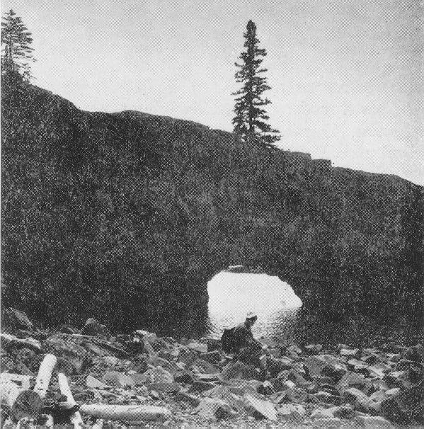
48

49

50

51
. \" \"IGNACE ISLAND Banding; (horizontal, inclined, vertical). Geological boundary, observed.")
52 Map 2285 St. Ignace Island and Adjacent Islands NIPIGON SYMBOLS Scale, l inch to 50 mites N.T.S- Reference: 42D/11,42D/12, 42D/13, Glacial s (f/ae. 420/14, 52A79,52A716 Sma// bedrock outcrop. Area of bedrock outcrop. Bedding, top indicated by arrow; (inclined, vertical, overturned). " "IGNACE ISLAND Banding; (horizontal, inclined, vertical). Geological boundary, observed. Geological boundary, position interpreted. Fault; (observed, assumed). Spot indi cates down throw side, arrow indicates horizontal movement. LEGEND CENOZOIC3 Lineament. QUATERNARY Lava flow; top in direction of arrow. RECENT Jointing; (horizontal, inclined, vertical). PLEISTOCENE,. Swamp and stream deposits. Till, sand, gravel, clay. Anticline, syncline, with plunge. UNNFORMITY PRECAMBRIAN* Drill hole; (vertical, inclined). LATE PRECAMBRIAN (PROTEROZOIC) Motor road. Provincial highway number encircled where applicable. KEWEENAWAN SUPERGROUP MAFIC INTRUSIVE ROCKS C uiij.su id,-x. i ^^^ T8"/ /', J VbkBuller? Pt LAKE Other road. SUPERIOR 10a Diabase. Wb Gabbro. We Anorthosite. Wa Diorite. We Gabbro (sills). Trail, portage, winter road. INTRUSIVE NTACT OSLER GROUP Building. 9 Township boundary, unsurveyed. Rhyolite porphyry boulder conglom erate. UNNFORMITY Location of mining property, unsur veyed. See list of properties and occurrences. FELSIC IGNEOUS ROCKSC 8a 8b 8c 8d Red rhyolite porphyry. Grey rhyolite porphyry. Trachyte. Felsite. VOLCANIC ROCKS 7a ' 7b 7c 7d Basalt with zeolite amygdu/es. Basalt, massive; minor andesite. Agglomerate. Basalt with quartz and agate amygdu/es. 7e Basalt with prehnite amygdu/es. Contained in unit 6b, 7f Interflow sediments. LIST OF PROPERTIES AND OCCURRENCES SEDIMENTARY ROCKS 6a Conglomerate. Sb Mudstone with shale and limestone. Se Sandstone and mudstone; facies of unit 6b. Sd Lithic sandstone; facies of unit 6a. 7. Addicks Canadian Properties Limited. 2. J. L. Carroll 11968]. 3. St. Ignace Harbour Prospect. Date in square brackets indicates date of last major work. UNNFORMITY SIBLEY GROUP* 5/1 5h Sg 5f ONTARIO DIVISION OF MINES HONOURABLE LEO BERNIER, Minister of Natural Resources Se 5d W. Q. MACNEE, Deputy Minister o/ Natural Resources G. A. Jewett, Executive Director, Division of Mines E. G. Pye, Director, Geological Branch Se Sb Sa SOURCES OF INFORMATION Lithic siltstone. Orthoquartzite and limestone. Orthoquartzite. Orthoquartzite and limestone (red and buff). Orthoquartzite. Arkose and shalv siltstone (red and buff). Orthoquartzite, minor greywacke. Conglomerate. Greywacke. UNNFORMITY LOCALLY DISNFORMABLE Geology by J. F. Giguere and assistants, Geological Branch, Geology was not tied to surveyed lines. MIDDLE PRECAMBRIAN (PROTEROZOIC) Aeromagnetic maps 2124G, 2125G, 2132G, 2139G; ODM-GSC. ANIMIKIE GROUPS Map 2285 Map 2137, Nipigon-Schrieber Sheet, Geological Com pilation Series, Scale 1 inch to 4 miles, issued 1968, Ministry of Natural Resources. ROVE FORMATION "l 4c Black shale and minor limestone. 4b Basalt and lithic siltstone. 4a Black shale. ST. IGNACE ISLAND Preliminary maps; P. 615, St. Ignace Is/and and Vicinity (West Part), scale 1 inch to K mile, issued P St. Ignace Island and Vicinity (East Part), scale 1 inch to X mile, issued INDETERMINATE NTACT GUNFLINT FORMATION and Adjacent Islands 3c Black shale with minor chert. 3b Shaly greywacke. 3a Conglomerate and orthoquartzite, THUNDER BAY DISTRICT Cartography by C. A. Harris and assistants, Surveys and Mapping Branch, Base map derived from maps of the Forest Resources Inventory, Surveys and Mapping Branch. Scale l: 63,360 or l Inch to l Mile Magnetic declination in the area was approximately O", l 2 3 UNNFORMITY EARLY PRECAMBRIAN (ARCHEAN) FELSIC TO INTERMEDIATE IGNEOUS ROCKS Wilson Island Quartz diorite. ST.X C IGNACE JUSLAND 1 Granitic rocks unsubdivided. 1a Granite. 1b Porphyritic granite. Afl Silver. Cu Copper. S Sulphide mineralization. Unconsolidated deposits. Cenozoic deposits are rep resented by the lighter coloured and uncoloured areas of the map. "Bedrock geology. Outcrops and inferred extensions of each rock map unit are shown respectively in deep and light tones of the same colour. Where, in places, a formation is too narrow to show colour and must be represented in black, a short black bar appears in the appropriate block. The Mafic Intrusive Rocks (unit W) may be partly equivalent in age to the Felsic Igneous rocks (unit 8). d The Sibley Group sedimentary rocks and underlying sedimentary sequences are in stratigraphical order. Lambert Canlvmal Protection, Standard Paratetls 4ta3ff arid 53*30
As compaction and cementation of these sediments eventually occur, which area will become siltstone? A) A B) B C) C D) D
 A B) B C) C D) D") 1. A student obtains a cup of quartz sand from a beach. A saltwater solution is poured into the sand and allowed to evaporate. The mineral residue from the saltwater solution cements the sand grains together,
1. A student obtains a cup of quartz sand from a beach. A saltwater solution is poured into the sand and allowed to evaporate. The mineral residue from the saltwater solution cements the sand grains together,
Which sample best shows the physical properties normally associated with regional metamorphism? (1) A (3) C (2) B (4) D
 A (3) C (2) B (4) D") 1 Compared to felsic igneous rocks, mafic igneous rocks contain greater amounts of (1) white quartz (3) pink feldspar (2) aluminum (4) iron 2 The diagram below shows how a sample of the mineral mica breaks
1 Compared to felsic igneous rocks, mafic igneous rocks contain greater amounts of (1) white quartz (3) pink feldspar (2) aluminum (4) iron 2 The diagram below shows how a sample of the mineral mica breaks
=%REPORT RECONNAISSANCE OF CHISHOLM LAKE PROSPECT. October 25, 1977
 =%REPORT ON FIELD RECONNAISSANCE OF CHISHOLM LAKE PROSPECT October 25, 1977 Bruce D. Vincent Imperial Oil Limited, Minerals - Coal, CALGARY, ALBERTA CHISHOLM LAKE PROSPECT Introduction The Chisholm Lake
THESE TERMS GOVERN YOUR USE OF THIS DOCUMENT
 THESE TERMS GOVERN YOUR USE OF THIS DOCUMENT Your use of this Ontario Geological Survey document (the Content ) is governed by the terms set out on this page ( Terms of Use ). By downloading this Content,
Version 1 Page 1 Barnard/George/Ward
 The Great Mineral & Rock Test 1. Base your answer to the following question on the table below which provides information about the crystal sizes and the mineral compositions of four igneous rocks, A,
Rocks. Rocks are composed of 1 or more minerals. Rocks are classified based on how they formed (origin). 3 classes of rocks:
. 3 classes of rocks:") ROCKS Rocks If a mineral is a naturally occurring homogeneous solid, inorganically formed, with a definite chemical composi:on and a crystalline structure then what is a rock? Rocks Rocks are composed
ROCKS Rocks If a mineral is a naturally occurring homogeneous solid, inorganically formed, with a definite chemical composi:on and a crystalline structure then what is a rock? Rocks Rocks are composed
RR#7 - Multiple Choice
 1. Which mineral is mined for its iron content? 1) hematite 2) fluorite 3) galena 4) talc 2. Which rock is composed of the mineral halite that formed when seawater evaporated? 1) limestone 2) dolostone
Page 1. Name: 1) Which diagram best shows the grain size of some common sedimentary rocks?
 Which diagram best shows the grain size of some common sedimentary rocks?") Name: 1) Which diagram best shows the grain size of some common sedimentary rocks? 1663-1 - Page 1 5) The flowchart below illustrates the change from melted rock to basalt. 2) Which processes most likely
Name: 1) Which diagram best shows the grain size of some common sedimentary rocks? 1663-1 - Page 1 5) The flowchart below illustrates the change from melted rock to basalt. 2) Which processes most likely
AGGREGATE RESOURCES OF ONTARIO (ARO) METADATA
 METADATA") AGGREGATE RESOURCES OF ONTARIO (ARO) METADATA GENERAL INFORMATION Official Name of the Data Set or Information Holding: Aggregate Resources of Ontario Acronyms are Used to Identify the Data Set or Information
AGGREGATE RESOURCES OF ONTARIO (ARO) METADATA GENERAL INFORMATION Official Name of the Data Set or Information Holding: Aggregate Resources of Ontario Acronyms are Used to Identify the Data Set or Information
Local: (705) Toll Free: , ext (inside Canada, United States) Local: (705) Toll Free: , ext.
 Toll Free: , ext (inside Canada, United States) Local: (705) Toll Free: , ext.") THESE TERMS GOVERN YOUR USE OF THIS DOCUMENT Your use of this Ontario Geological Survey document (the Content ) is governed by the terms set out on this page ( Terms of Use ). By downloading this Content,
THESE TERMS GOVERN YOUR USE OF THIS DOCUMENT Your use of this Ontario Geological Survey document (the Content ) is governed by the terms set out on this page ( Terms of Use ). By downloading this Content,
MEMO. TO: Dennis Lapoint CC: FROM: Eriaan Wirosono DATE: April, 20 th 2014 SUBJECT: Exploration activity report March-April 2014_EW
 TO: Dennis Lapoint CC: FROM: Eriaan Wirosono DATE: April, 20 th 2014 SUBJECT: Exploration activity report March-April 2014_EW MEMO 1. Highlights and Productivity Overview pan sampling on target Areas 1
GEOLOGICAL MAPPING OF SKARNS ON THE SHEEP AND EWE CLAIMS, TURNAGAIN RIVER, B.C. DURING THE 1979 SUMMER SEASON
 GEOLOGICAL MAPPING OF SKARNS ON THE SHEEP AND EWE CLAIMS, TURNAGAIN RIVER, B.C. DURING THE 1979 SUMMER SEASON CLAIMS: Sheep 1 to 4 Ewe 1, 3, 4 to 8 Lamb 12 Fraction Liard Mining Division, B.C. NTS 104
Practice Test Rocks and Minerals. Name. Page 1
 Name Practice Test Rocks and Minerals 1. Which rock would be the best source of the mineral garnet? A) basalt B) limestone C) schist D) slate 2. Which mineral is mined for its iron content? A) hematite
A. IGNEOUS Rocks formed by cooling and hardening of hot molten rock called magma (within crust or at its surface).
.") EARTH SCIENCE 11 CHAPTER 5 NOTES KEY How Earth's Rocks Were Formed Early geologists believed that the physical features of the Earth were formed by sudden spectacular events called CATASTROPHES. Modern
EARTH SCIENCE 11 CHAPTER 5 NOTES KEY How Earth's Rocks Were Formed Early geologists believed that the physical features of the Earth were formed by sudden spectacular events called CATASTROPHES. Modern
MRD 281. Official Name of the Data Set or Information Holding: Northeastern Ontario Rhyolite Database
 MRD 281 GENERAL INFORMATION Official Name of the Data Set or Information Holding: Northeastern Ontario Rhyolite Database Acronyms are Used to Identify the Data Set or Information Holding: MRD281 Describe
Local: (705) Toll Free: , ext (inside Canada, United States) Local: (705) Toll Free: , ext.
 Toll Free: , ext (inside Canada, United States) Local: (705) Toll Free: , ext.") THESE TERMS GOVERN YOUR USE OF THIS DOCUMENT Your use of this Ontario Geological Survey document (the Content ) is governed by the terms set out on this page ( Terms of Use ). By downloading this Content,
THESE TERMS GOVERN YOUR USE OF THIS DOCUMENT Your use of this Ontario Geological Survey document (the Content ) is governed by the terms set out on this page ( Terms of Use ). By downloading this Content,
Chapter 10. Chapter Rocks and the Rock Cycle. Rocks. Section 1 Rocks and the Rock Cycle
 Chapter 10 Rocks 1 Chapter 10 Section 1 Rocks and the Rock Cycle 2 10.1 Rocks and the Rock Cycle Magma is the parent material for all rocks. Once the magma cools and hardens, many changes can occur. Geology:
Local: (705) Toll Free: , ext (inside Canada, United States) Local: (705) Toll Free: , ext.
 Toll Free: , ext (inside Canada, United States) Local: (705) Toll Free: , ext.") THESE TERMS GOVERN YOUR USE OF THIS DOCUMENT Your use of this Ontario Geological Survey document (the Content ) is governed by the terms set out on this page ( Terms of Use ). By downloading this Content,
THESE TERMS GOVERN YOUR USE OF THIS DOCUMENT Your use of this Ontario Geological Survey document (the Content ) is governed by the terms set out on this page ( Terms of Use ). By downloading this Content,
Review - Unit 2 - Rocks and Minerals
 Review - Unit 2 - Rocks and Minerals Base your answers to questions 1 and 2 on the diagram below, which shows the results of three different physical tests, A, B, and C, that were performed on a mineral.
We are committed to providing accessible customer service. If you need accessible formats or communications supports, please contact us.
 We are committed to providing accessible customer service. If you need accessible formats or communications supports, please contact us. Nous tenons à améliorer l accessibilité des services à la clientèle.
GEOLOGY OF THE NICOLA GROUP BETWEEN MISSEZULA LAKE AND ALLISON LAKE
 GEOLOGY OF THE NICOLA GROUP BETWEEN MISSEZULA LAKE AND ALLISON LAKE (92H/15E. 10E1 By V. A. Preto INTRODUCTION Mapping was continued southward from the area covered in 1973 and an additional 55 square
NOA ASSESSMENT HARRIS QUARRY MENDOCINO COUNTY, CALIFORNIA TABLE OF CONTENTS
 NOA ASSESSMENT HARRIS QUARRY MENDOCINO COUNTY, CALIFORNIA TABLE OF CONTENTS Introduction... 1 Scope of Services... 1 Project Location and Description... 1 Geologic Setting... 1 Regional Geology... 1 Site
THESE TERMS GOVERN YOUR USE OF THIS DOCUMENT
 THESE TERMS GOVERN YOUR USE OF THIS DOCUMENT Your use of this Ontario Geological Survey document (the Content ) is governed by the terms set out on this page ( Terms of Use ). By downloading this Content,
COMPOSITIONAL TERMS: FELSIC : light colored INTERMEDIATE : medium shades MAFIC : dark colored ULTRAMAFIC : rare (composition of the mantle)
") GEOLOGY 306 Laboratory NAME: Instructor: TERRY J. BOROUGHS SECTION: Common Rocks (Chapter 2) For this assignment, you will require: a streak plate, glass plate, magnet, dilute hydrochloric (HCl) acid,
GEOLOGY 306 Laboratory NAME: Instructor: TERRY J. BOROUGHS SECTION: Common Rocks (Chapter 2) For this assignment, you will require: a streak plate, glass plate, magnet, dilute hydrochloric (HCl) acid,
Local: (705) Toll Free: , ext (inside Canada, United States) Local: (705) Toll Free: , ext.
 Toll Free: , ext (inside Canada, United States) Local: (705) Toll Free: , ext.") THESE TERMS GOVERN YOUR USE OF THIS DOCUMENT Your use of this Ontario Geological Survey document (the Content ) is governed by the terms set out on this page ( Terms of Use ). By downloading this Content,
THESE TERMS GOVERN YOUR USE OF THIS DOCUMENT Your use of this Ontario Geological Survey document (the Content ) is governed by the terms set out on this page ( Terms of Use ). By downloading this Content,
LAB 2 IDENTIFYING MATERIALS FOR MAKING SOILS: ROCK AND PARENT MATERIALS
 LAB 2 IDENTIFYING MATERIALS FOR MAKING SOILS: ROCK AND PARENT MATERIALS Learning outcomes The student is able to: 1. understand and identify rocks 2. understand and identify parent materials 3. recognize
The MAPLE BAY PROJECT Copper Silver - Gold
 The MAPLE BAY PROJECT Copper Silver - Gold Good grade and tonnage potential within close proximity to Tidewater The Maple Bay Copper Silver Gold Project covers highly favourable geological host rocks of
THESE TERMS GOVERN YOUR USE OF THIS DOCUMENT
 THESE TERMS GOVERN YOUR USE OF THIS DOCUMENT Your use of this Ontario Geological Survey document (the Content ) is governed by the terms set out on this page ( Terms of Use ). By downloading this Content,
MRD 228 METADATA. Official Name of the Data Set or Information Holding: Physiography of Southern Ontario
 MRD 228 METADATA GENERAL INFORMATION Official Name of the Data Set or Information Holding: Physiography of Southern Ontario Acronyms are Used to Identify the Data Set or Information Holding: MRD228 Describe
The 3 types of rocks:
 Igneous Rocks and Intrusive Igneous Activity The 3 types of rocks:! Sedimentary! Igneous! Metamorphic Marble 1 10/7/15 SEDIMENTARY ROCKS Come from rocks sediments (rock fragments, sand, silt, etc.) Fossils
I m good. Thank you.
 I m good. Thank you. The Rock Cycle Ag Earth Science Chapter 3.1 A natural occurring, inorganic crystalline material with a unique chemical composition. mineral A consolidated mixture of minerals rock
THESE TERMS GOVERN YOUR USE OF THIS DOCUMENT
 THESE TERMS GOVERN YOUR USE OF THIS DOCUMENT Your use of this Ontario Geological Survey document (the Content ) is governed by the terms set out on this page ( Terms of Use ). By downloading this Content,
CEE 437 Lecture 10 Rock Classification. Thomas Doe
 CEE 437 Lecture 10 Rock Classification Thomas Doe Igneous Origins Intrusive Batholithic or plutonic: phaneritic Dikes or sills that chill rapidly: aphanitic Extrusive deposition as melt (lava) pyroclastic
Name Class Date. Chapter 3 Rocks Chapter Test. Write the letter that best answers the question or completes the statement on the line provided.
 Chapter 3 Rocks Chapter Test Multiple Choice Write the letter that best answers the question or completes the statement on the line provided. 1. Which of the following is true about rocks? a. Rocks are
GEOPHYSICAL DATA SET (GDS) 1084B METADATA
 1084B METADATA") GEOPHYSICAL DATA SET (GDS) 1084B METADATA GENERAL INFORMATION Official Name of the Data Set or Information Holding: Ontario Airborne Geophysical Surveys, Magnetic Gradiometer and Gamma-Ray Spectrometric
GEOPHYSICAL DATA SET (GDS) 1084B METADATA GENERAL INFORMATION Official Name of the Data Set or Information Holding: Ontario Airborne Geophysical Surveys, Magnetic Gradiometer and Gamma-Ray Spectrometric
MRD273-REV METADATA. Acronyms are Used to Identify the Data Set or Information Holding: MRD273-REV
 MRD273-REV METADATA GENERAL INFORMATION Official Name of the Data Set or Information Holding: Ontario Precambrian Bedrock Magnetic Susceptibility Geodatabase for 2001 to 2012 Acronyms are Used to Identify
SOUTH CERRO AZUL STRATIGRAPHIC SECTION. Upper Cerro Azul flow of the Servilleta Basalt (Tsbcau) Lower Sandlin unit (Tsl)
 Lower Sandlin unit (Tsl)") Figure A3-01 cobbles claysilt general grain size sand pebbles vf f m c vc SOUTH CERRO AZUL STRATIGRAPHIC SECTION Top at 18 m. Upper Cerro Azul flow of the Servilleta Basalt (Tsbcau) 15 Basalt: Very dark
Figure A3-01 cobbles claysilt general grain size sand pebbles vf f m c vc SOUTH CERRO AZUL STRATIGRAPHIC SECTION Top at 18 m. Upper Cerro Azul flow of the Servilleta Basalt (Tsbcau) 15 Basalt: Very dark
Answers. Rocks. Year 8 Science Chapter 8
 Answers Rocks Year 8 Science Chapter 8 p171 1 Rocks are made up of minerals such as quartz, feldspars, micas, and calcite. Different rocks are made up of different combinations of minerals. 2 Igneous,
Rock Identification. invisible rhyolite andesite basalt komatiite. visible granite diorite gabbro peridotite
 Rock Identification The samples in this lab are arranged into four groups: igneous, sedimentary, metamorphic, and unknown. Study the igneous, sedimentary, and metamorphic collections to get an idea of
 UNIT-3 PETROLOGY QUESTIONS AND ANSWERS 1. What is mean by Rock? It is defined as natural solid massive aggregates of minerals forming the crust of the earth 2. Define Petrology? The branch of geology dealing
1. Base your answer to the following question on on the photographs and news article below. Old Man s Loss Felt in New Hampshire
 UNIT 3 EXAM ROCKS AND MINERALS NAME: BLOCK: DATE: 1. Base your answer to the following question on on the photographs and news article below. Old Man s Loss Felt in New Hampshire FRANCONIA, N.H. Crowds
Rocks Rock- A group of minerals, glass, mineroid bound together in some way.
 Rocks Rock- A group of minerals, glass, mineroid bound together in some way. All rocks fit into one of three categories: Igneous- formed by the cooling and hardening of hot molten rock Sedimentary- formed
Sediment and sedimentary rocks Sediment
 Sediment and sedimentary rocks Sediment From sediments to sedimentary rocks (transportation, deposition, preservation and lithification) Types of sedimentary rocks (clastic, chemical and organic) Sedimentary
MRD 207 METADATA DETAIL PAGE
 MRD 207 METADATA DETAIL PAGE The following represents the Basic description of an information holding. To obtain more information about this holding, see the section named Contacts. GENERAL INFORMATION
Which rock is shown? A) slate B) dunite C) gneiss D) quartzite
 slate B) dunite C) gneiss D) quartzite") 1. Which metamorphic rock will have visible mica crystals and a foliated texture? A) marble B) quartzite C) schist D) slate 2. The recrystallization of unmelted material under high temperature and pressure
1. Which metamorphic rock will have visible mica crystals and a foliated texture? A) marble B) quartzite C) schist D) slate 2. The recrystallization of unmelted material under high temperature and pressure
Unit 2: Minerals and Rocks Practice Questions
 Name: Date: 1. Which mineral is white or colorless, has a hardness of 2.5, and splits with cubic cleavage? 6. Base your answer(s) to the following question(s) on the photograph of a sample of gneiss below.
MRD283-REV METADATA. Acronyms are Used to Identify the Data Set or Information Holding: MRD283-REV
 MRD283-REV METADATA GENERAL INFORMATION Official Name of the Data Set or Information Holding: Ambient Groundwater Geochemistry Data for Southern Ontario, 2007 2014 Acronyms are Used to Identify the Data
DISCOVERY OF MINERALISED PORPHYRY & MAGNETITE-COPPER-GOLD AT KAMARANGAN
 MEDUSA MINING LIMITED ABN: 60 099 377 849 Unit 7, 11 Preston Street Como WA 6152 PO Box 860 Canning Bridge WA 6153 Telephone: +618-9367 0601 Facsimile: +618-9367 0602 Email: admin@medusamining.com.au Internet:
Introduction to Prospecting. Session Two Geology
 Introduction to Prospecting Session Two Geology The Earth Earth is 4.6 billion years old (Ba). Bacteria & algae +3.5 Ba. Microscopic animals ~2 Ba. Animals ~600 million years (Ma) old. Mankind about 100,000
Sediments and Sedimentary Rocks
 Sediments and Sedimentary Rocks (Shaping Earth s Surface, Part 2) Science 330 Summer 2005 What is a sedimentary rock? Products of mechanical and chemical weathering Account for about 5 percent of Earth
2013 GEOLOGICAL ASSESSMENT REPORT SHERIDAN HILL PROPERTY
 2013 GEOLOGICAL ASSESSMENT REPORT ON THE SHERIDAN HILL PROPERTY NEW WESTMINSTER MINING DIVISION BRITISH COLUMBIA NTS 092G07 49 16 31 NORTH LATITUDE, 122 39 48 WEST LONGITUDE PREPARED FOR Sheridan Hill
I. Uniformitarianism- James Hutton s 2-part theory states: A. The geologic processes now at work were also active in the past B. The present physical
 How Earth s Rocks Were Formed I. Uniformitarianism- James Hutton s 2-part theory states: A. The geologic processes now at work were also active in the past B. The present physical features of Earth were
SANDER GEOPHYSICS LW 42D13SW ISLE ST. IGNACE RICHMONl
 SANDER GEOPHYSICS LW 42D13SW8363 83.1-117 ISLE ST. IGNACE 010 1305 RICHMONl REPORT ON THE HELICOPTER BORNE EM AND MAGNETOMETER SURVEY OFF ST. IGNACE ISLAND, LAKE SUPERIOR THUNDERBAY MINING DISTRICT, ONTARIO
B) color B) Sediment must be compacted and cemented before it can change to sedimentary rock. D) igneous, metamorphic, and sedimentary rocks
 color B) Sediment must be compacted and cemented before it can change to sedimentary rock. D) igneous, metamorphic, and sedimentary rocks") 1. Which characteristic of nonsedimentary rocks would provide the least evidence about the environment in which the rocks were formed? A) structure B) color C) crystal size D) mineral composition 2. Which
1. Which characteristic of nonsedimentary rocks would provide the least evidence about the environment in which the rocks were formed? A) structure B) color C) crystal size D) mineral composition 2. Which
THESE TERMS GOVERN YOUR USE OF THIS DOCUMENT
 THESE TERMS GOVERN YOUR USE OF THIS DOCUMENT Your use of this Ontario Geological Survey document (the Content ) is governed by the terms set out on this page ( Terms of Use ). By downloading this Content,
CEE 437 Lecture 11 Rock Classification. Thomas Doe
 CEE 437 Lecture 11 Rock Classification Thomas Doe Translation of Mineral Properties to Rock Properties Comparison of mineral properties to rock properties Rocks have lower strength, especially tensile
Earth Science Chapter 6 Rocks
 Earth Science Chapter 6 Rocks I. Rocks and the Rock Cycle * Material that makes up the solid part of the Earth. * Made of a variety of different combinations of minerals and organic matter. A. Three Major
Igneous Rocks. Sedimentary Rocks. Metamorphic Rocks
 Name: Date: Igneous Rocks Igneous rocks form from the solidification of magma either below (intrusive igneous rocks) or above (extrusive igneous rocks) the Earth s surface. For example, the igneous rock
1. Base your answer to the following question on The diagram below represents a part of the crystal structure of the mineral kaolinite.
 1. Base your answer to the following question on The diagram below represents a part of the crystal structure of the mineral kaolinite. An arrangement of atoms such as the one shown in the diagram determines
Geology 12 FINAL EXAM PREP. Possible Written Response Exam Questions
 Geology 12 FINAL EXAM PREP Possible Written Response Exam Questions Use this study guide to prepare for the written response portion of the final exam. Name FINAL EXAM - POSSIBLE WRITTEN RESPONSE QUESTIONS
MRD 229-Revised METADATA
 GENERAL INFORMATION MRD 229-Revised METADATA Official Name of the Data Set or Information Holding: Till Compositional Database: Investigation of the Overburden Signature of the Caribou Lake Greenstone
THESE TERMS GOVERN YOUR USE OF THIS DOCUMENT
 THESE TERMS GOVERN YOUR USE OF THIS DOCUMENT Your use of this Ontario Geological Survey document (the Content ) is governed by the terms set out on this page ( Terms of Use ). By downloading this Content,
Instructor: Ms. Terry J. Boroughs Geology 8 INTRODUCTION TO ROCKS AND THE ROCK CYCLE
 DATE DUE: Name: Instructor: Ms. Terry J. Boroughs Geology 8 INTRODUCTION TO ROCKS AND THE ROCK CYCLE Instructions: Read each question carefully before selecting the BEST answer Provide specific and detailed
THESE TERMS GOVERN YOUR USE OF THIS DOCUMENT
 THESE TERMS GOVERN YOUR USE OF THIS DOCUMENT Your use of this Ontario Geological Survey document (the Content ) is governed by the terms set out on this page ( Terms of Use ). By downloading this Content,
INTRODUCTION REGIONAL GEOLOGY. N. St-Jean 1, L. Hunt 1 and R.L. Sherlock 1
 37. Preliminary Results from Mapping a New Exposure of the Basal Unconformity Between the Hearst and Larder Lake Assemblages, Skead Township, Northeastern Ontario N. St-Jean 1, L. Hunt 1 and R.L. Sherlock
Page 1. Name:
 Name: 1) What is the approximate density of a mineral with a mass of 262.2 grams that displaces 46 cubic centimeters of water? A) 6.1 g/cm 3 C) 1.8 g/cm 3 B) 5.7 g/cm 3 D) 12.2 g/cm 3 2) In which two Earth
THESE TERMS GOVERN YOUR USE OF THIS DOCUMENT
 THESE TERMS GOVERN YOUR USE OF THIS DOCUMENT Your use of this Ontario Geological Survey document (the Content ) is governed by the terms set out on this page ( Terms of Use ). By downloading this Content,
Mishi Lake Gold Property Mishibishu Lake Area, Wawa
 Mishi Lake Gold Property Mishibishu Lake Area, Wawa Location, Accessibility, Infrastructure and Local Resources The property is located 40 km west of Wawa, Ontario, in the Mishibishu Lake Area, Sault Ste.
Unit 2 Exam: Rocks & Minerals
 Name: Date: 1. Base your answer(s) to the following question(s) on the 2001 edition of the Earth Science Reference Tables, the map and cross section below, and your knowledge of Earth science. The shaded
Local: (705) Toll Free: , ext (inside Canada, United States) Local: (705) Toll Free: , ext.
 Toll Free: , ext (inside Canada, United States) Local: (705) Toll Free: , ext.") THESE TERMS GOVERN YOUR USE OF THIS DOCUMENT Your use of this Ontario Geological Survey document (the Content ) is governed by the terms set out on this page ( Terms of Use ). By downloading this Content,
THESE TERMS GOVERN YOUR USE OF THIS DOCUMENT Your use of this Ontario Geological Survey document (the Content ) is governed by the terms set out on this page ( Terms of Use ). By downloading this Content,
Prospecting Report 'S Office i DB Property, B.C. -J Negro Creek Nelson Mining District NTS 82F.050. Operator: Kootenay Gold Inc.
 . '.' I"' i9 12 Prospecting Report 'S Office i DB Property, B.C. -J Negro Creek Nelson Mining District NTS 82F.050 Operator: Kootenay Gold Inc. Owner: Darlene Lavoie Work Performed Summer of 2007 Report
ROCK CLASSIFICATION AND IDENTIFICATION
 Name: Miramar College Grade: GEOL 101 - Physical Geology Laboratory SEDIMENTARY ROCK CLASSIFICATION AND IDENTIFICATION PRELAB SECTION To be completed before labs starts: I. Introduction & Purpose: The
Evolution of the Earth
 Evolution of the Earth http://static.newworldencyclopedia.org/f/fe/geologic_clock.jpg Evolution of the Earth Solar system, 4.6 byr Collapse of a nebula Star forms as gravity concentrates material at center
Topics that will be discussed
 Topics that will be discussed The Rock Cycle Igneous Rock Sedimentary Rock Metamorphic Rock The Rock Cycle -Rocks The parent material for all rocks is MAGMA. What is MAGMA? -Rock forming Minerals Are:
We are committed to providing accessible customer service. If you need accessible formats or communications supports, please contact us.
 We are committed to providing accessible customer service. If you need accessible formats or communications supports, please contact us. Nous tenons à améliorer l accessibilité des services à la clientèle.
GEOLOGY AND MINERAL RESOURCES OF INDIAN RESERVE 26
 ) 41HI3NW94I4 I R NO 26 1*A1 MANITOULIN ISLAND 010 -f?;. GEOLOGY AND MINERAL RESOURCES OF INDIAN RESERVE 26 September 16, 1975 D. G. Innes, Resident Geologist Sudbury District Ministry of Natural Resources
Rocks and the Rock Cycle notes from the textbook, integrated with original contributions
 Rocks and the Rock Cycle notes from the textbook, integrated with original contributions Alessandro Grippo, Ph.D. Gneiss (a metamorphic rock) from Catalina Island, California Alessandro Grippo review Rocks
Nickel Division - Sudbury Operations
 * *-.. FALCONBRIDGE NICKEL MINES LIMITED Nickel Division - Sudbury Operations Falconbridge, Ontario 002261 GRAHAM 010 GEOLOGY OF TllE NORTH QUARTER OP LOT 2, CON. IV, GRAHAM TOWNSHIP, DISTRICT OP SUDBURY,
Lab 2: Rocks Page 1 of 8
 Lab 2: Rocks Page 1 of 8 LAB 2: ROCK IDENTIFICATION DUE: Friday, Feb. 25 Directions About 90 rocks specimens will be on tables in the classroom. The rocks will be arranged on the lab tables during class,
lin iibii i nm l i 31M05SE A.446 GILLIES 010
 ..-... lin iibii i nm l i 31M05SE0892 63A.446 GILLIES 010 t GEOLOGICAL REPORT ON HOUND CHUTE LAKE PROPERTY OF SILVER TOWER MINES LIMITED GILLIES LIMIT COBALT, ONTARIO (p Z A The property is located n Blocks
Sedimentary Environments Chapter 8
 Sedimentary Environments Chapter 8 Does not contain complete lecture notes. To be used to help organize lecture notes and home/test studies. What is a sedimentary rock? Sedimentary rocks are products of
Wednesday 22 May 2013 Morning
 Wednesday 22 May 2013 Morning AS GCE GEOLOGY F792/01 Rocks Processes and Products *F713000613* Candidates answer on the Question Paper. OCR supplied materials: None Other materials required: Ruler (cm/mm)
EPS 50 Lab 4: Sedimentary Rocks
 Name: EPS 50 Lab 4: Sedimentary Rocks Grotzinger and Jordan, Chapter 5 Introduction In this lab we will classify sedimentary rocks and investigate the relationship between environmental conditions and
Engineering Geology. Igneous rocks. Hussien Al - deeky
 Igneous rocks Hussien Al - deeky 1 The Geology Definition of Rocks In Geology Rock is defined as the solid material forming the outer rocky shell or crust of the earth. There are three major groups of
Notes: Note. Township of GODSON Report NQ: 12. Diamond Dniiing. Hole NQ Footage Date. July/56. July/56. Aug/56. Aug/56. Claim NQ 487' K ' l-a
 Diamond Dniiing S2F«4NW«194 12 GODSON 010 Township of GODSON Report NQ: 12 Work performed by: KENNCO EXPLORATIONS (CANADA) LTD. Claim NQ Hole NQ Footage Date Note K 25434 l 487' July/56 l-a 48' July/56
Cape Breton Island Mineral Inventory Studies: A Sandstone Quarry Development Opportunity at Graham River (NTS 11F/14), Inverness County
, Inverness County") Report of Activities 2001 23 Cape Breton Island Mineral Inventory Studies: A Sandstone Quarry Development Opportunity at Graham River (NTS 11F/14), Inverness County G. J. DeMont and J. E. Hawken Compilation
Report of Activities 2001 23 Cape Breton Island Mineral Inventory Studies: A Sandstone Quarry Development Opportunity at Graham River (NTS 11F/14), Inverness County G. J. DeMont and J. E. Hawken Compilation
Name Class Date. In your textbook, read about the nature of igneous rocks. Use each of the terms below just once to complete the following statements.
 CHAPTER 5 Igneous Rocks SECTION 5.1 What are igneous rocks? In your textbook, read about the nature of igneous rocks. Use each of the terms below just once to complete the following statements. basaltic
Local: (705) Toll Free: , ext (inside Canada, United States) Local: (705) Toll Free: , ext.
 Toll Free: , ext (inside Canada, United States) Local: (705) Toll Free: , ext.") THESE TERMS GOVERN YOUR USE OF THIS DOCUMENT Your use of this Ontario Geological Survey document (the Content ) is governed by the terms set out on this page ( Terms of Use ). By downloading this Content,
THESE TERMS GOVERN YOUR USE OF THIS DOCUMENT Your use of this Ontario Geological Survey document (the Content ) is governed by the terms set out on this page ( Terms of Use ). By downloading this Content,
The Cobalt Rainbow. Airborne geophysical maps show that a north trending aeromagnetic high suggests further undiscovered mineralisation.
 The Cobalt Rainbow The property is located on Greenstone Creek, approximately 4.8 kilometres south west of the creek mouth. The property is located about 24 km due west of Campbell River, in the east-central
GEOLOGY OF THE DO27 PIPE: A PYROCLASTIC KIMBERLITE IN THE LAC DE GRAS PROVINCE, NWT, CANADA
 GEOLOGY OF THE DO27 PIPE: A PYROCLASTIC KIMBERLITE IN THE LAC DE GRAS PROVINCE, NWT, CANADA Margaret Harder 1, Casey Hetman 2, Barbara Scott Smith 3, and Jennifer Pell 1 1 Peregrine Diamonds Ltd. 2 Mineral
Sedimentary Rocks. Weathering. Mechanical & Chemical Weathering. Sediments. Lithification. Deposition. Transport. Erosion.
 Lithification Sedimentary Rocks Sediments Deposition Transport Erosion Weathering Weathering The sediments that make up sedimentary rocks are produced by: Mechanical & Chemical Weathering Mechanical Weathering
Chapter 4 Rocks & Igneous Rocks
 Chapter 4 Rocks & Igneous Rocks Rock Definition A naturally occurring consolidated mixture of one or more minerals e.g, marble, granite, sandstone, limestone Rock Definition Must naturally occur in nature,
GY 112 Lecture Notes Rock Review
 GY 112 Lecture Notes D. Haywick (2006) 1 GY 112 Lecture Notes Rock Review Lecture Goals: A) Recap of rock types B) Recap of the rock cycle C) Sedimentary rocks: their role in earth history Textbook reference:
Pacific Northwest Rock Lab, Part II. Igneous Rocks. Name Per.
 Name Per. Pacific Northwest Rock Lab, Part II After you ve classified all your rocks, place their numbers next to the names and read the information about the rock. Check the classifications here (igneous,
Rock Star 101. Introduction to Rocks.
 Rock Star 101 Introduction to Rocks www.mineralsed.ca Lesson 1: Rocks are made of minerals. Element, Mineral, Rock, Outcrop Lesson 2: Rock formation is cyclic. Lesson 3: Igneous rocks crystallize from
Chapter 6 Pages of Earth s Past: Sedimentary Rocks
 Chapter 6 Pages of Earth s Past: Sedimentary Rocks Introduction! Drilling into the bottom of the North Sea, we encounter: " Soft mud and loose sand, silt, pebbles, and shells. Then: " Similar materials
THESE TERMS GOVERN YOUR USE OF THIS DOCUMENT
 THESE TERMS GOVERN YOUR USE OF THIS DOCUMENT Your use of this Ontario Geological Survey document (the Content ) is governed by the terms set out on this page ( Terms of Use ). By downloading this Content,
THESE TERMS GOVERN YOUR USE OF THIS DOCUMENT
 THESE TERMS GOVERN YOUR USE OF THIS DOCUMENT Your use of this Ontario Geological Survey document (the Content ) is governed by the terms set out on this page ( Terms of Use ). By downloading this Content,
Geologic Trips San Francisco and the Bay Area
 Excerpt from Geologic Trips San Francisco and the Bay Area by Ted Konigsmark ISBN 0-9661316-4-9 GeoPress All rights reserved. No part of this book may be reproduced without written permission in writing,