THESE TERMS GOVERN YOUR USE OF THIS DOCUMENT
|
|
|
- Horace Lane
- 6 years ago
- Views:
Transcription
1 THESE TERMS GOVERN YOUR USE OF THIS DOCUMENT Your use of this Ontario Geological Survey document (the Content ) is governed by the terms set out on this page ( Terms of Use ). By downloading this Content, you (the User ) have accepted, and have agreed to be bound by, the Terms of Use. Content: This Content is offered by the Province of Ontario s Ministry of Northern Development and Mines (MNDM) as a public service, on an as-is basis. Recommendations and statements of opinion expressed in the Content are those of the author or authors and are not to be construed as statement of government policy. You are solely responsible for your use of the Content. You should not rely on the Content for legal advice nor as authoritative in your particular circumstances. Users should verify the accuracy and applicability of any Content before acting on it. MNDM does not guarantee, or make any warranty express or implied, that the Content is current, accurate, complete or reliable. MNDM is not responsible for any damage however caused, which results, directly or indirectly, from your use of the Content. MNDM assumes no legal liability or responsibility for the Content whatsoever. Links to Other Web Sites: This Content may contain links, to Web sites that are not operated by MNDM. Linked Web sites may not be available in French. MNDM neither endorses nor assumes any responsibility for the safety, accuracy or availability of linked Web sites or the information contained on them. The linked Web sites, their operation and content are the responsibility of the person or entity for which they were created or maintained (the Owner ). Both your use of a linked Web site, and your right to use or reproduce information or materials from a linked Web site, are subject to the terms of use governing that particular Web site. Any comments or inquiries regarding a linked Web site must be directed to its Owner. Copyright: Canadian and international intellectual property laws protect the Content. Unless otherwise indicated, copyright is held by the Queen s Printer for Ontario. It is recommended that reference to the Content be made in the following form: <Author s last name>, <Initials> <year of publication>. <Content title>; Ontario Geological Survey, <Content publication series and number>, <total number of pages>p. Use and Reproduction of Content: The Content may be used and reproduced only in accordance with applicable intellectual property laws. Non-commercial use of unsubstantial excerpts of the Content is permitted provided that appropriate credit is given and Crown copyright is acknowledged. Any substantial reproduction of the Content or any commercial use of all or part of the Content is prohibited without the prior written permission of MNDM. Substantial reproduction includes the reproduction of any illustration or figure, such as, but not limited to graphs, charts and maps. Commercial use includes commercial distribution of the Content, the reproduction of multiple copies of the Content for any purpose whether or not commercial, use of the Content in commercial publications, and the creation of value-added products using the Content. Contact: FOR FURTHER INFORMATION ON The Reproduction of Content The Purchase of MNDM Publications PLEASE CONTACT: BY TELEPHONE: BY MNDM Publication Services MNDM Publication Sales Local: (705) Toll Free: , ext (inside Canada, United States) Local: (705) Toll Free: , ext (inside Canada, United States) Crown Copyright Queen s Printer Local: (416) Toll Free: (inside Canada, United States) Pubsales@ndm.gov.on.ca Pubsales@ndm.gov.on.ca Copyright@gov.on.ca
2 LES CONDITIONS CI-DESSOUS RÉGISSENT L'UTILISATION DU PRÉSENT DOCUMENT. Votre utilisation de ce document de la Commission géologique de l'ontario (le «contenu») est régie par les conditions décrites sur cette page («conditions d'utilisation»). En téléchargeant ce contenu, vous (l'«utilisateur») signifiez que vous avez accepté d'être lié par les présentes conditions d'utilisation. Contenu : Ce contenu est offert en l'état comme service public par le ministère du Développement du Nord et des Mines (MDNM) de la province de l'ontario. Les recommandations et les opinions exprimées dans le contenu sont celles de l'auteur ou des auteurs et ne doivent pas être interprétées comme des énoncés officiels de politique gouvernementale. Vous êtes entièrement responsable de l'utilisation que vous en faites. Le contenu ne constitue pas une source fiable de conseils juridiques et ne peut en aucun cas faire autorité dans votre situation particulière. Les utilisateurs sont tenus de vérifier l'exactitude et l'applicabilité de tout contenu avant de l'utiliser. Le MDNM n'offre aucune garantie expresse ou implicite relativement à la mise à jour, à l'exactitude, à l'intégralité ou à la fiabilité du contenu. Le MDNM ne peut être tenu responsable de tout dommage, quelle qu'en soit la cause, résultant directement ou indirectement de l'utilisation du contenu. Le MDNM n'assume aucune responsabilité légale de quelque nature que ce soit en ce qui a trait au contenu. Liens vers d'autres sites Web : Ce contenu peut comporter des liens vers des sites Web qui ne sont pas exploités par le MDNM. Certains de ces sites pourraient ne pas être offerts en français. Le MDNM se dégage de toute responsabilité quant à la sûreté, à l'exactitude ou à la disponibilité des sites Web ainsi reliés ou à l'information qu'ils contiennent. La responsabilité des sites Web ainsi reliés, de leur exploitation et de leur contenu incombe à la personne ou à l'entité pour lesquelles ils ont été créés ou sont entretenus (le «propriétaire»). Votre utilisation de ces sites Web ainsi que votre droit d'utiliser ou de reproduire leur contenu sont assujettis aux conditions d'utilisation propres à chacun de ces sites. Tout commentaire ou toute question concernant l'un de ces sites doivent être adressés au propriétaire du site. Droits d'auteur : Le contenu est protégé par les lois canadiennes et internationales sur la propriété intellectuelle. Sauf indication contraire, les droits d'auteurs appartiennent à l'imprimeur de la Reine pour l'ontario. Nous recommandons de faire paraître ainsi toute référence au contenu : nom de famille de l'auteur, initiales, année de publication, titre du document, Commission géologique de l'ontario, série et numéro de publication, nombre de pages. Utilisation et reproduction du contenu : Le contenu ne peut être utilisé et reproduit qu'en conformité avec les lois sur la propriété intellectuelle applicables. L'utilisation de courts extraits du contenu à des fins non commerciales est autorisé, à condition de faire une mention de source appropriée reconnaissant les droits d'auteurs de la Couronne. Toute reproduction importante du contenu ou toute utilisation, en tout ou en partie, du contenu à des fins commerciales est interdite sans l'autorisation écrite préalable du MDNM. Une reproduction jugée importante comprend la reproduction de toute illustration ou figure comme les graphiques, les diagrammes, les cartes, etc. L'utilisation commerciale comprend la distribution du contenu à des fins commerciales, la reproduction de copies multiples du contenu à des fins commerciales ou non, l'utilisation du contenu dans des publications commerciales et la création de produits à valeur ajoutée à l'aide du contenu. Renseignements : POUR PLUS DE RENSEIGNEMENTS SUR la reproduction du contenu l'achat des publications du MDNM les droits d'auteurs de la Couronne VEUILLEZ VOUS ADRESSER À : Services de publication du MDNM Vente de publications du MDNM Imprimeur de la Reine PAR TÉLÉPHONE : PAR COURRIEL : Local : (705) Numéro sans frais : , poste 5691 (au Canada et aux États-Unis) Local : (705) Numéro sans frais : , poste 5691 (au Canada et aux États-Unis) Local : Numéro sans frais : (au Canada et aux États-Unis) Pubsales@ndm.gov.on.ca Pubsales@ndm.gov.on.ca Copyright@gov.on.ca
3 O OMNR - OGS 1985 Ontario Ministry of Natural Hon Alan w a. A. Minister Resources John R. Sloan Deputy Minister ONTARIO GEOLOGICAL SURVEY Open File Report 5529 Gold-Quartz-Arsenopyrite Vein Deposits Localized near the Base of the Flinton Group, Kaladar and Barrie Townships, Southeastern Ontario by E.P. Dillon 1985 This project was part of the Southeastern Ontario Geological Survey (SOGS) which was funded equally by the Federal Department of Regional Economic Expansion (DREE) and the Ontario Ministry of Natural Resources under the Minerals Program of the Eastern Ontario Subsidiary Agreement. Parts of this publication may be quoted if credit is given. It is recommended that reference to this report be made in the following form: Dillon, E.P. 1985: Gold-Quartz-Arsenopyrite Vein Deposits Localized near the Base of the Flinton Group, Kaladar and Barrie Townships, Southeastern Ontario; Ontario Geological Survey, Open File Report 5529, 69p., 5 figures, 2 tables, 6 photos.
4
5 Ontario Geological Survey OPEN FILE REPORT Open file reports are made available to the public subject to the following conditions: This report is unedited. Discrepancies may occur for which the Ontario Geological Survey does not assume liability. Recommendations and statements of opinion expressed are those of the author or authors and are not to be construed as statements of government policy. Open file copies may be read at the following locations: Mines Library Ontario Ministry of Natural Resources 8th Floor, 77 Grenville Street, Toronto The office of the Regional or Resident Geologist in whose district the area covered by this report is located. Handwritten notes and sketches may be made from this report. Check with the Library or Region al or Resident Geologist's office as to whether there is a copy of this report that may be borrowed. The Library or Regional or Resident Geologist's office will also give you information on copying ar rangements. A copy of this report is available for Inter-Library Loan. This report is on file in the Regional or Resident Geologists' office(s) located at: 255 Metcalf St. Box 70 Tweed, Ont. KOK 3JO The right to reproduce this report is reserved by the Ontario Ministry of Natural Resources. Permission for other reproductions must be obtained in writing from the Director, Ontario Geological Survey. VG. Milne, Director Ontario Geological Survey 111
6
7 TABLE OF CONTENTS Page ABSTRACT xiii INTRODUCTION l PURPOSE AND SCOPE OF THE PROGRAM l REGIONAL GEOLOGY 2 REGIONAL STRUCTURE 5 DETAILED PROPERTY DESCRIPTIONS 6 Addington Gold Mine, Kaladar Township 6 Introduction 6 History of Development 6 Detailed Geology 8 Description of Units 12 a) Tudor Formation 12 b) Ore Chimney Formation 15 c) Bishop Corners Formation 16 d) Lessard Formation 19 Detailed Structure 19 Mineralization 23 Summary 26 Ore Chimney Mine, Barrie Township 27 Introduction 27 History of Development 27 Detailed Geology 29 Description of Units 32 a) Tudor Formation 32 b) Ore Chimney Formation 34 c) Bishop Corners Formation 34 Mineralization 38 Summary 39 Ore Mountain Occurrence, Barrie Township 41 Introduction 41 History of Development 41 Detailed Geology 43 Description of Units 43 a) Tudor Formation 43 b) Ore Chimney Formation 44 c) Bishop Corners Formation 45 Detailed Structure 45 Mineralization 46 Summary 46 GENERAL SUMMARY 47 CONCLUSIONS 51 REFERENCES 53 V
8
9 LIST OF FIGURES Page Figure 1: Location of gold study areas within their 3 regional geologic setting Figure 2: Geology of the Addington Mine Area, Kaladar 9 Township Figure 3: Sketch of major structural features of the 22 Addington Area. Inset sketch suggests alternative structural generation of the Ore Chimney Formation due to shearing Figure 4: Geology of the Ore Chimney Mine Area, 31 Barrie Township Figure 5: Geology of the Ore Mountain Occurrence, 42 Barrie Township Vll
10
11 LIST OF TABLES Page Table I: Formations exposed at the Addington 10 Property Table II: Summary of ore shoot, Ore Chimney Mine, 39 after Campbell 1957 IX
12
13 Plate 1: Plate 2: Plate 3: Plate 4: Plate 5: Plate 6: LIST OF PLATES Minor folding of quartzite pebbles in Bishop Corners Formation conglo merate, Addington Property Cross-bedding in Bishop Corners Formation quartzite, Addington Property Bishop Corners Formation conglomerate, Addington Property, showing elongation of pebbles and minor folding Pillows in Tudor mafic metavolcanics, Ore Chimney Property Cross beds in quartzite, basal Bishop Corners Formation, Ore Chimney Property Stretched pebbles in conglomerate of Bishop Corners Formation, Ore Chimney Property Page XI
14
15 ABSTRACT The geological and structural setting of three shear zone hosted gold-base metal-quartz vein occurrences are described in detail. These occurrences, the Addington Gold mine, Ore Chimney and the Ore Mountain occurrence are hosted within a biotite-garnet schist unit, called the Ore Chimney Formation. Evidence is presented regarding the stratigraphic or structural significance of the Ore Chimney Formation in controlling quartz-vein formation and base-precious metal concentration. The schistosity developed within the biotite garnet schist (Ore Chimney Formation) as well as the accompanying mineralized quartz veins parallel the major post-flinton regional foliation. Minor, less well developed mineralized quartz veins hosted in lower Flinton micaceous quartzites provide further evidence that places the mineralizing event during the major post-flinton regional metamorphism. Additional structural controls are evidenced by the pipe-like shape of individual gold-rich zones localized within a major linear shear structure at the Addington Mine which parallels the plunge of minor fold structures on the property. The present limited data base precludes a thorough interpretation of the relationships of major and minor structures in controlling gold concentration within the major shear structure. Xlll
16
17 The mineralized shear structures at the three properties are localized above and below the basal Flinton unconformity where competence differences between older mafic metavolcanics and the quartzite and conglomerate above resulted in shearing, dilatency and subsequent gold-base metal quartz vein deposition during the major regional metamorphic event circa 1050 Ma ago. xv
18
19 GOLD-QUARTZ-ARSENOPYRITE VEIN DEPOSITS LOCALIZED NEAR THE BASE OF THE FLINTON GROUP, KALADAR AND BARRIE TOWNSHIPS, SOUTHEASTERN ONTARIO 1985 by E.P. Dillon 1 Geologist, Mineral Deposits Section, Ontario Geological Survey, Toronto. Manuscript approved for publication by Janet S. Springer for A.C. Colvine, Section Chief, Mineral Deposits Section, November 28, This report is published by permission of V.G. Milne, Director, Ontario Geological Survey. x vi i
20
21 INTRODUCTION During 1983 the geological and structural setting of the quartz-arsenopyrite-gold occurrences located near the lower boundary of the Flinton Group, in Kaladar and Barrie townships, Southeastern Ontario were studied. These occurrences included two past-producing properties, the Addington Mine and the Ore Chimney Mine, and one small occurrence, the Ore Mountain (Figure 1). The three properties were mapped at 1:2500 scale on flagged 100 x 50m grids and samples of typical units associated with the mineralized areas were collected for thin section study. PURPOSE AND SCOPE OF THE PROGRAM The study was designed to investigate the relative significance of structural and stratigraphic position in siting the gold-arsenopyrite mineralization hosted by quartz veins, which is localized in shear zones immediately adjoining the basal Flinton unconformity. Parallel studies by P. Barron (this report) expand the enquiry on the significance of the Flinton unconformity as a preferentially mineralized zone by examining base metal-gold-quartz dolomite veins hosted by carbonate or metaclastic rocks. These veins are also located at or near the unconformity, albeit within rocks of different sedimentary facies.
22 -2- This program, presently in its infant stage, has already produced significant results. It remains to apply these results in unexplored regions hopefully to outline additional significant mineralization. REGIONAL GEOLOGY The geological setting of the study area has been discussed by Barron (this report). Important background detail discussed below is the stratigraphic, structural and metamorphic inter-relationships of the Tudor mafic metavolcanics and the younger, unconformably overlying metaclastic rocks of the Flinton Group (Bishop Corners and Lessard Formations). Figure l generally illustrates the disposition of the major lithologies in the study area. Much of it has recently been described in detail (the Kaladar area, Wolff 1982 and the Clarendon Lake area, Moore and Morton 1980) and this brief introductory discussion is largely based on previous work. The oldest rocks of the study area are mafic metavolcanics (tholeiites, Wolff 1982) of the Hermon Group, Tudor Formation (Lumbers 1969) in which occasional primary flow features are seen. These include poorly preserved relict vesicles often infilled with carbonate, and pillows, whose selvedges are only partially preserved. Top determinations are not definitive (Wolff 1982). Metamorphic grade is upper greenschist to amphibolite facies.
23 -3- I,, i l l l i 6 T- W O
24 -4- These rocks are predominantly massive, fine-grained, equigranular, dark to medium grey-green amphibolites. They are composed of hornblende and plagioclase with minor chlorite and biotite and traces of pyrite and magnetite. Carbonate, up to 1(^ of the rock, occurs as smears along cleavage or foliation planes. Close to the contact with the Flinton Group a gneissic to schistose variety of the amphibolite occurs which shows segregation of mafic and felsic components into thin Klmm) discontinuous lenses and layers. These rocks are fine grained and composed predominantly of hornblende, plagioclase and minor biotite. The Tudor Formation is intruded by a series of granodiorite-trondhjemite plutons. The Elzevir batholith, which outcrops east of the immediate study area, is a medium-grained biotite granodiorite to quartz monzonite which shows granoblastic to gneissic texture. The Northbrook-Cross Lake pluton, exposed both north and east of the area, consists of a medium-grained biotite-trondhjemite to biotite-granodiorite. Within the study area metavolcanic rocks of the Tudor Formation are overlain unconformably by metasedimentary rocks of the Flinton Group whose basal members are the Bishop Corners Formation and above it the Lessard Formation (Moore and Morton 1980; Thompson 1982; Moore and Thompson The basal unit, the Bishop Corners Formation, consists of feldspathic quartzite and quartzite-pebble conglomerate.
25 -5- The Lessard Formation above it comprises calcareous meta-arkose and gritty quartz-pebble conglomerate. Both units will be discussed in more detail in association with the property descriptions. Close to the basal Flinton unconformity is the controversial Ore Chimney Formation (Moore and Thompson 1980). This unit which lies at, above or below the unconformity is a dark grey to black, well foliated, medium to fine grained hornblende-biotite-garnet schist.the mineralized quartz vein systems at the Addington, Ore Chimney and Ore Mountain properties lie conformably within this unit. REGIONAL STRUCTURE The properties mapped lie within the Flinton syncline, shown on the Kaladar map sheet (OGS Map 2432, Wolff 1982). In general a thin wedge of metaclastic Flinton Group is synclinally infolded into the thicker sequence of mafic metavolcanic rocks, the Hermon Group. Two large intrusive bodies east and west of the area may have controlled the provenance and basin structure during Flinton sedimentation resulting in the trough-like distribution of lithologies. Subsequent regional movement resulted in major synclinal folding and shearing which are in evidence today.
26 -6- DETAILED PROPERTY DESCRIPTIONS Addington Gold Mine - Lots 24 and 25, Concession VI, Kaladar Township Introduction: The Addington gold property is located in lots 24 and 25, concession VI, Kaladar Township, Southeastern Ontario (NTS 31C/11). It is reached by a gravel bush road which runs north from the Flinton road approximately 1.6 km west of Highway 41 (Figure 1). History of Development The Addington Mine was discovered in 1881 by the Golden Fleece Mining Company. In 1887 the Adelaide Mining Company of Baltimore, Maryland sank two shallow shafts and erected a ten-stamp mill. Little production occurred until From 1907 to 1915 the mine was operated by the APB Mining Company under option. From 1915 to 1922 the Cobalt- Frontenac Mining Company deepened one shaft to 60 feet, the inclined shaft (N63 0 E) to 100 feet and put in a level at 100 feet from which they sunk a winze 66 feet. A further 350 feet of drifting and 402 feet of cross-cutting were completed at this time. Harding (1942) reports that up to 1919 a total of $10, worth of gold was produced. In 1922 a cyanide plant was installed and production for that year totalled 50 ounces of gold and 26 ounces of silver from an undisclosed tonnage of ore (Wolff 1982).
27 -7- Further development work, carried out on the 200 foot level, in 1927 disclosed these veins having average widths of 20, 30 and 12 to 15 feet. The property was purchased by Rich Rock Gold Mines in In 1932 C.N. Thompson pumped out the main shaft to the 200 foot level and re-sampled the workings. Subsequently the mill was partially reopened and some mining carried out. In 1935 the property was acquired under option by the Consolidated Mining and Smelting Company Limited (Cominco Ltd.). In 1936 Addington Mines Limited, a subsidiary of Cominco, took over control of the property. From 1936 to 1938 they deepened the inclined shaft to 535 feet, sank a winze 273 feet below the 500 foot level with levels at 625 feet and 700 feet, conducted 3033 feet of crosscutting and 7096 feet of drifting on the 300, 400, 500 and 700 foot levels. They also drilled eight surface and sixty-eight underground diamond drill holes totalling 8856 feet, to outline an estimated reserve of 256,000 tons grading $5.60/ton (0.17 oz/ton at $33.00 gold) with a further 103,000 tons of probable ore (Source Mineral Deposits Files, Ontario Geological Survey, Toronto). The mill was removed from the site in 1940 and the 2 shafts and larger pits were infilled in 1975 under Cominco 1 s supervision. The property was acquired under option by E fi B Explorations in 1980 and is presently being re-evaluated based on diamond drilling carried out from 1981 to 1983.
28 -8- Detailed Geology The mineralized quartz veins at the Addington Mine outcrop for a distance of 915 m (Figure 2) in a 2 to 10 m wide shear zone, localized at or near the junction between the older Tudor mafic metavolcanic rocks to the west and the younger Flinton Group metasedimentary rocks to the east. Within this shear zone lenses and stringers of quartz and associated tourmaline contain arsenopyrite, pyrite, ankerite and gold. Harding (1942) noted accessory chalcopyrite, pyrrhotite and scheelite within the mineralized zone. During the present survey a 1.6 kilometre strike length of the property was mapped at 1:2500 scale. A pace and compass base line was run 1000 m north and 600 m south from the main shaft site. Cross lines at 100 m intervals were run 200 to 500 m east and 600 to 1500 m west of the base line. The geology of the property is illustrated in Fig. 2. It shows a series of synclines and anticlines, inferred from present lithologic and stratigraphic relationships, trending approximately north 10 0 east and plunging moderately to steeply to the north. The major units encountered are summarized in Table 1. The central part of the study area (Figure 2) is underlain by a thick sequence of mafic metavolcanics which to the east are unconformably overlain by quartzite, meta-arkose and conglomerates of the Bishop Corners Formation. In the western part of the area the
29 HW!H, W V ' w w FLINTON GROUP 4 Lessard Formation Calcareous quartzo-feldspathic mete-sandstone 3 Bishop Corners Formation a) Meta-arkose, quartzite b)quartzfte-pebme conglomerate UNCONFORMITY ^"^ 2 Ore Chimney Formation Hornblende-olotltegarnet schist HERMON GROUP 1 Tudor Formation Amphibolite schist, amphibolite metres. \\ Foliation. v x Inclined, vertical Bedding Inclined Fault, aisumed Geological contact, approximate, inferred ^***"^ ^- ** ' * - -* f "^ oyncnne. Hiferreej Anticline. Inferred Trench, ph Buildlng( foiindation waste dump Plunge, pebbles In conglomerate Plunge, fold axe* r
30
31 -10- TABLE FORMATIONS EXPOSED AT THE ADDINGTON PROPERTY STRATIGRAPHIC UNIT LITHOLOGY FLINTON GROUP Lessard Formation Bishop Corners Formation Calcareous Quartzo- Feldspathic metasandstone and gritty sandstone conglomerate Meta-arkose, quartzite and quartzite pebble conglomerate UNCONFORMITY * Ore Chimney Formation Hornblende-biotite-garnet schist, hornblende-biotite schist HERMON GROUP Tudor Formation Hornblende-plagioclase gneiss and schist, hornblendechlorite ± biotite amphibolite schist *The Ore Chimney Formation is a narrow lithological unit which lies immediately below the basal Flinton unconformity. It is a unclear whether this "formation" is a stratigraphic unit present prior to Flinton sedimentation or if it developed at the Tudor-Flinton contact during post-flinton shearing and metamorphism.
32 -11- metavolcanics are unconformably overlain by both the Bishop Corners Formation and calcareous quartz-feldspathic meta-sandstone and conglomerate of the Lessard Formation. A narrow synclinal tongue of Bishop Corners Formation (quartzite and conglomerate) appears to have been infolded into the mafic metavolcanics in the north central part of the area. This can be reasoned from the stratigraphic repetition of biotite-garnet schists around the outcrop of the small structure and a slight thickening of this unit at the nose (Bell 1949). All rocks exposed in the study area exhibit a welldeveloped foliation trending 350 to and dipping 65 0 to 80 0 east. Within the mafic metavolcanics a poorly preserved earlier foliation trending 020 to and dipping 75 0 to 85 0 east is seen to intersect the dominant foliation. The trend of the hinge planes of major synclines inferred to occur within the property are parallel to sub-parallel to this earlier foliation. This older foliation is only evident in the central party of the volcanic belt and appears to have been totally destroyed as the stronger post Flinton foliation has developed near the margins of the volcanics. Within the clastic metasediments of the Flinton Group the main foliation parallels the well-developed later planes evident within the volcanics. The quartzite units,
33 -12- where well cross-bedded, exhibit primary bedding attitudes trending 30 to 50 0 east of north. The overlying sediments appear to lie at an approximately 30 0 angular unconformity upon these older metavolcanic rocks. Minor "Z" folding is evident within the quartzite-pebble conglomerates exposed in the east side of the study area (Plate l). Hinge planes trend parallel to the regional foliation and plunges are oriented at 60 to 70 0 to the south. The pebbles within the meta-conglomerates have their longest dimension plunging southward at 56 0 to 70 0 within the major foliation. In plan view these pebbles are elongate parallel to the regional foliation trend. Description of Units a. Tudor Formation. The mafic metavolcanic rocks exposed on the Addington property are fine to medium-grained, medium to dark green amphibolites of two textural varieties. The predominant type is a medium grained, dark green and buff, well-foliated schistose to gneissic amphibolite which exhibits moderate segregation of mafic (hornblende with minor chlorite) and felsic (plagioclase and minor quartz) components into their discontinuous bands and lenses one to three mm wide. This type shows disoriented acicular hornblende grains (0.5 to l cm) along foliation planes. Minor disseminated pyrite and magnetite are common
34
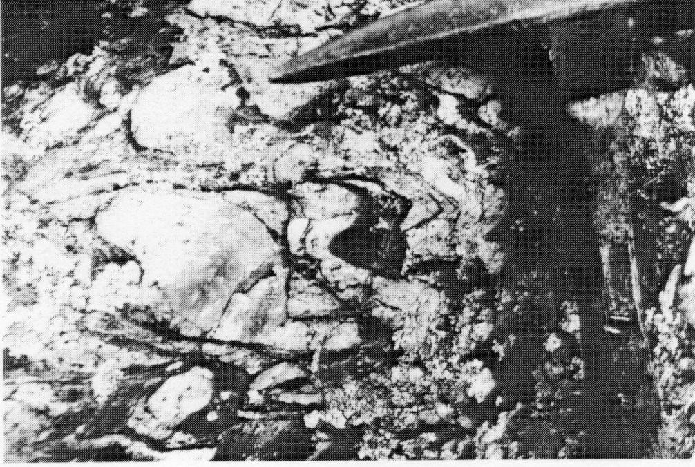
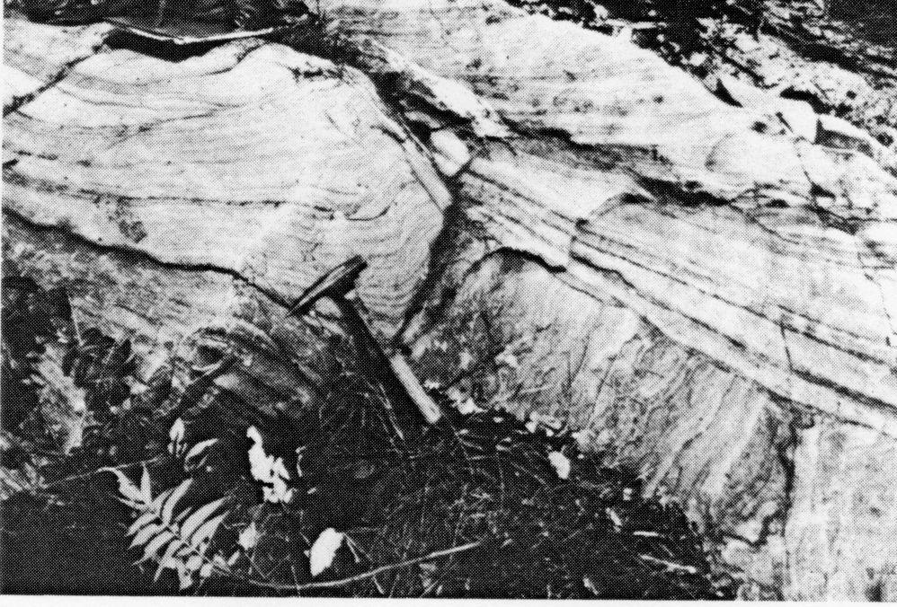
35 -13- Plate 1: Minor folding of quartzite pebbles in Bishop Corners Formation conglomerate, Addington Property.
36
37 -14- accessories and carbonate, as fine fracture fillings and smears along foliation planes is present in varying amounts. Carbonate content reaches a maximum of approximately 1(^ within 10 m of the mineralized shear zone. In thin section these rocks comprise dark green, fine to medium grained prismatic to acicular hornblende (50 to 90**) with plagioclase (lq-25%), quartz (2-^) and carbonate d-5%). Chlorite content of these rocks averages l-s 1* and can comprise up to 20% of the mafics. Biotite content averages l-3% and can comprise up to 30*6 of the mafics in these rocks. Metamorphically, biotite appears at the expense of amphibole and chlorite (T. Hart, personal communication, 1984). The second amphibolite type occurs throughout the volcanic sequence and present data do not indicate that two distinct and mappable units are present. It is a fine-grained dark green to black foliated to fissile rock which occasionally contains 2-5% subhedral fine-grained disseminated pyrite ( mm). This rock occurs as 0.25 to 0.50 m zones within the gneissic amphibolite. In thin section these rocks show fine-grained subhedral to anhedral hornblende (60 to 80%). Associated minor opaque minerals include pyrite and magnetite (tr -3% total).
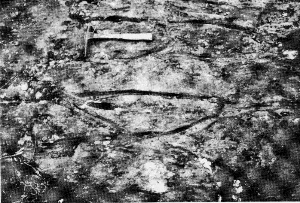
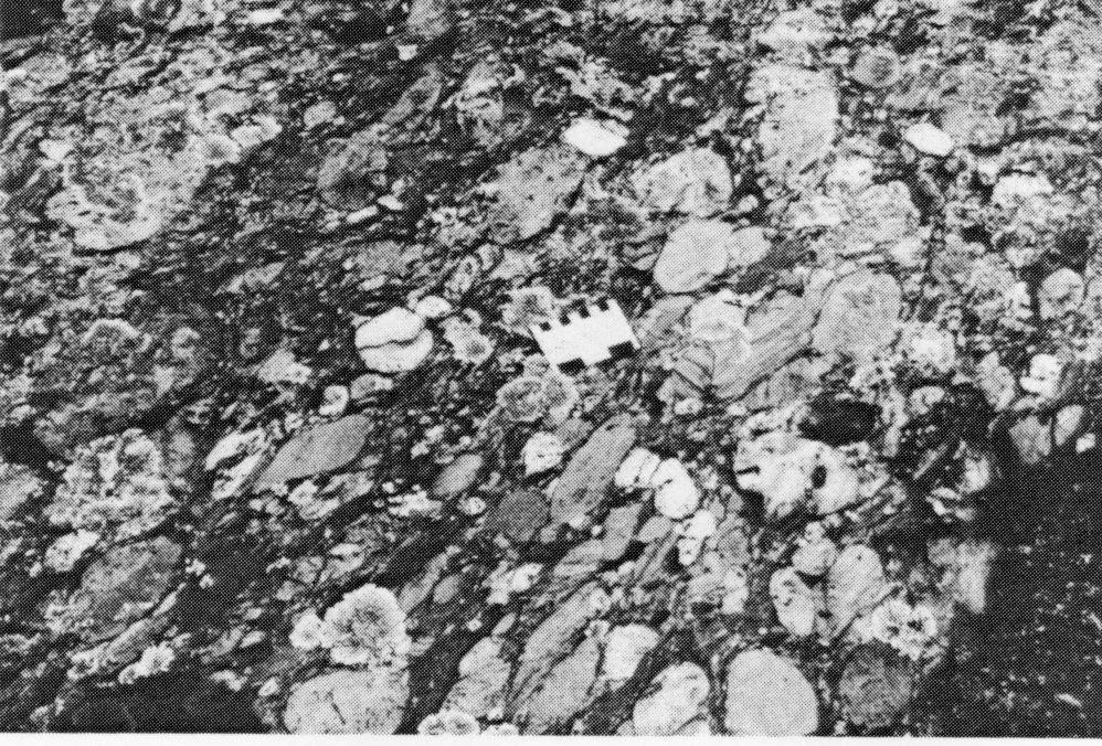
38 -15- b. Ore Chimney Formation A narrow zone (2-10 m wide) of hornblende-biotitegarnet schist lies at the contact between the Tudor Formation and the Bishop Corners Formation (Figure 2). This unit, which is usually slightly magnetic, is fine to medium-grained, dark green to black and schistose in texture. It contains 5 to SO 5* subhedral to euhedral dark red to black garnet pyroblasts (0.3 - lcm). The dark red-black garnets are often associated with increased magnetite content. Commonly exposures of this unit show 1-2 m thick garnetiferous schist zones separated by 1-3 m thick hornblende-chlorite-biotite schist. Exposures of this unit are discontinuous and correlation between outcrops is inferred in many cases. This unit is exposed wherever the volcanics and quartzites are in contact, albeit discontinuously, perhaps, suggesting that it represents a mafic sediment deposited upon Tudor Formation rocks prior to Flinton clastic sedimentation. This unit hosts the quartz-tourmaline-arsenopyritegold veins and has been traced intermittently, on surface, the full length of the property (1600 m) in the main mineralized area. It is also exposed in the vicinity of the small syncline in the north central part of the property (Figure 2) and to the west where Flinton clastic rocks overlie Tudor metavolcanics. Where well exposed, the unit contains a series of discontinuous 2-15 cm wide quartz
39 -16- stringers, often accompanied by fine-grained aphanitic to coarse-grained prismatic black tourmaline, parallelling the major foliation direction. Trace to 5% arsenopyrite and pyrite occur along quartz vein margins and within fine cross fractures in the milky white quartz. Field observations indicate a compositional grading within this unit across its width from metavolcanics to overlying metasediments. Near the contact with the volcanics the biotite and garnet content falls and the hornblende content increases; the rock becomes muscovite-rich as the contact with the oval Flinton sediments is approached. This may suggest a certain amount of mixing of mafic and siliciclastic sediments within the contact areas by assimilation during shearing and metamorphism or during primary sedimentary deposition. One thin section of this unit showed 2Q* coarse subhedral garnets containing inclusions of magnetite, 25% biotite laths, 25% chlorite, ID-15% plagioclase, S-10% quartz and minor accessory opaques and tourmaline. Laths of chlorite and biotite are oriented parallel to schistosity and wrap around the garnets indicating that the garnets grew in place during shearing and regional metamorphism. c. Bishop Corners Formation Unconformably overlying the Tudor and Ore Chimney Formations are interbedded quartzite and quartzite-pebble
40 -17- conglomerate, which comprise the Bishop Corners Formation. Immediately above the Ore Chimney Formation is a m thickness of meta-arkose. It is a massive, fine to medium-grained, foliated buff-tan rock composed of quartz with minor feldspar, muscovite and traces of biotite. Away from the underlying hornblende-biotite-garnet schist these rocks become quartzitic and exhibit relict cross-bedding structures (Plate 2). The quartzite is in sharp contact with the quartzite-pebble conglomerate above it which also contains 0.5m to 2m discontinuous interbeds of quartzite. The massive quartzite at the base and interbedded within the conglomerate is buff tan to white, medium- grained, well laminated and frequently cross-bedded. section shows a mosaic of polygonal quartz grains with minor sericite, biotite and trace amounts of opaque minerals. massive quartz rocks. Thin The sericite indicates a foliation within these The quartzite-pebble conglomerate consists of 60 to 80?; 1-15 cm elongate clasts in a medium-grained matrix of micaceous quartzite to meta-arkose composition. in decreasing order of abundance, include: Clasts i. buff tan to white, laminated to cross-bedded quartzite, ii. iii. milky white vein quartz, and dark grey to black finely bedded quartzite.
41 -18- Plate 2: Cross-bedding in Bishop Corners Formation quartzite, Addington Property
42
43 -19- The conglomerate exhibits a well developed foliation with the pebbles stretched (Plate 3) approximately 3:1 parallel to the regional foliation direction. The matrix is well-foliated around the quartzite pebbles. d. Lessard Formation Approximately one kilometre west of the main mine property (Figure 2) is exposed a narrow strip of medium grained, massive to poorly foliated calcareous quartzo-feldspathic meta-sandstone. This light to medium-grey unit is often sandy to gritty in texture. Within it are 0.25 to 0.50 m interbeds of gritty conglomerate consisting of ID-30% cm quartz clasts in a calcareous sandstone matrix. This unit exhibits well defined foliation parallel to regional trends and overlies the Bishops Formation. Detailed Structure In general the gross structural relationships between the units mapped suggest a series of tightly folded synclines and anticlines (Figure 2) All units exposed in the property exhibit a moderate to well developed foliation trending to and dipping steeply to the east (65 to 85 0 ). The central part of the volcanic belt, exposed west of the main vein structure, exhibits a very subtle earlier foliation trending to 05 0 and dipping steeply eastwards and intersecting the major foliation at 15 0 to
44

45 -20- Plate 3: Bishop Corners Formation conglomerate, Addington Property showing elongation of pebbles and minor folding (lower right).
46
47 Cross-bedding structures in the quartzite units interbedded within quartzite-pebble conglomerate give bedding orientations trending 030 to OSO 0 and dipping eastwards at 70 to Top directions indicate east-facing beds within the sediments. Pillow structures preserved in Tudor metavolcanic rocks north of the map area indicate west facing flow tops (Moore and Morton 1980). The major vein-hosting structures and the quartz vein-hosted within the shear zone trend parallel to the major foliation direction and dip eastwards at 65 to Figures is a sketch of the major structural relationships observed on the Addington property. Minor folding within the conglomerate unit is indicated by folded quartzite pebbles. Hinge lines of these minor folds trend parallel or sub-parallel to the regional foliation direction and plunge 50 0 to 70 0 to the south. Clasts within the conglomerate exhibit extreme flattening and elongation parallel to the plunge of these fold hinge lines (Figure 3). Major faulting is not in evidence on the Addington mine property as no beds nor lithologic contacts appear to be disrupted or off set to any great degree. The minor cross-fault shown on Figure 2 in the west central part of the map area is drawn within an area of low wet ground with no exposure and the relationships of the units contacting in this area are inferred to be slightly offset. Shearing within Ore Chimney formation, the ore host, has taken place
48 -22-3,' 3,4 r i M [2 TO* l B X Foliation Bedding Plunge of minor folds Plunge of long dimention of quartz pebbles in conglomerate Synclinal axis Fault Shear zones developed during Post Flinton Regional Metamorphism FLINTON GROUP 4 Lessard Formation Calcareous quartzo-feldspathic meta-sandstone 3 Bishop Corners Formation a) Meta-arkose, quartzite. b) Quartzlte-pebble conglomerate ****-* UNCONFORMITY *^* 2 Ore Chimney Formation Hornblende-biotite-garnet schist HERMON GROUP 1 Tudor Formation Amphibolite schist, amphibolite Figure 3: A: B: Alternative interpretations of the gross structural relationships of the Ore Chimney Formation to Flinton-Tudor Rocks, Addington Mine, Kaladar Township General structural relationships assuming that Unit 2 (Ore Chimney Formation) is a stratigraphic unit. Similar overall structural and lithologic relation ships as in A except that unit 2 (Ore Chimney Form ation) has formed in major post-flinton shear structures resulting by jjdvement along the Tudor- Flinton contact.
49 -23- parallel to the regional foliation trend. If this structure is in fact a major fault, movement directions along the plane are not discernible. Bell (1949) describes this shear zone as a fault contact with the structure having undergone normal movement. He also noted two cross faults near the southern end of the property and although no displacement of units is in evidence, topographic features suggest possible linear structures present in the area (Figure 2). The unconformable relationships between the Flinton Group and the underlying mafic metavolcanic rocks is well documented in the southern part of the property. Firstly, cross-bedding within quartzite units indicates that the sediments strike to OSO 0 and dip to the east. Secondly, top directions indicate the sediments are east facing. Thirdly, pillow structures in mafic metavolcanics north of the study area indicate west facing flow tops (Moore and Morton 1980). Thus not only do the sediments strike at 15 to 30 0 from the trends of the contact with the volcanics but also they face opposite to the volcanics. Mineralization The main mineralized zone at the Addington property consists of a series of quartz-tourmaline veins hosted in the sheared hornblende-biotite-garnet schist of the Ore Chimney Formation. Subordinate, parallel, mineralized quartz-tourmaline veins have been located within Flinton
50 -24- Group metasediments (W. Johnson, personal communication, 1984). The veins are variable mineralized with pyrite, arsenopyrite, chalcopyrite and gold. The main shear zone is exposed intermittently for the full length of the property, however it appears to be well mineralized only in the vicinity of the main shaft and to the north. Short trenches, most of which are now infilled with soil and debris, were excavated on surface the full length of the main shear zone (Bell 1949). Today, exposure is limited to the trenches near the main shaft where a series of milky to clear quartz stringers and lenses with associated black tourmaline, from l to 8 cm in width, is exposed across widths of 2 to 10 m. Locally the quartz veins are cut by cross fractures smeared with carbonate and/or chlorite. Magnetite as streaks and thin lenses occurs both in the veins and within interveining hornblende-biotite schist. Towards the hanging wall muscovite can constitute up to 2Q* of the host rocks. The quartz veins parallel the regional foliation (approximately N10 0 E) and dip steeply (65 0 to 80 0 ) to the east. The ore zones located within the main shear structure are lensoid in shape with their longest dimension down dip (Bell 1949). The rake of these lenses is steep to the south parallel to the plunge of the regional lineation (W. Johnston, personal communication, 1984). Sulphide mineralization is localized along the quartz vein
51 -25- boundaries and in minor cross fractures within the quartz. Gold mineralization, though not visible in material examined, is reported to occur free in quartz gangue, in fractures in arsenopyrite, or in association with magnetite (Bell 1949). Throughout the remainder of the property quartz lenses and veins are common within volcanic, quartzite and conglomerates above and below the Flinton unconformity. In the eastern part of the property, tourmaline occurs in association with irregular pods and lenses of quartz in the conglomerates. Thin section studies of quartzite and conglomerate from the east part of the property show accessory and apparently detrital tourmaline particularly in the matrix of the conglomerate (T. Hart, personal communication, 1984). The source of the tourmaline associated with the quartz pods and mineralized quartz veins may be due to a remobilization of detrital tourmaline during shearing and regional metamorphism. The possibility that some of the tourmaline was introduced to the shear zone system during the mineralization event cannot be discounted. Much more detailed sampling and petrography are required to fully resolve this question. Earlier exploration at the Addington property has concentrated on defining the mineralization present in the main shear structure. Additional zones of hornblende-
52 -26- biotite-garnet schist located during the present survey and suggest other favourable exploration targets. These zones are exposed at the contact between underlying mafic metavolcanics and overlying clastic metasediments. They are sheared and contain minor quartz stringers with pyrite and arsenopyrite. Summary The gold mineralization at the Addington mine is hosted in a quartz stringer vein shear zone which is conformable with major regional foliation trends. This foliation cuts obliquely across the Flinton unconformity and is younger than it. The shear zone has formed near the base of the Flinton Group metaclastic sequence where it unconformably overlies Tudor mafic metavolcanics and appears to have formed in a mafic sediment (Ore Chimney Formation) which lies atop the volcanic pile. The significance of the unconformity in localizing mineralization is suggested to be purely structural in nature. It appears that ductility contrasts between underlying metavolcanics and overlying quartzite and conglomerate resulted in shearing during post-flinton regional metamorphism. This shearing was concentrated in this region of variable competency between units which coincides with an unconformity. The Ore Chimney Formation which may have been a weaker intervening unit became heavily sheared. Dilatant zones developed along this
53 -27- linear shear structure providing the permeable system into which mineralizing solutions migrated and finally deposited their base metals and gold. It appears that the key to extensive shearing and subsequent quartz veining and sulphide-gold mineralization is the development of the Ore Chimney Formation at the Tudor-Flinton contact. The location of this unit should be first priority in exploration programs for these vein-type gold occurrences. The Ore Chimney Mine: Lot 35, Concession I f Barrie Township Introduction The Ore Chimney Mine is located in Lot 35, Concession I, Barrie Township. The property is accessible via a small gravel road which runs north of the Harlowe road approximately 1.8 kilometre east of Highway 41 (NTS 31C/14). History of Development Gold mineralization was originally discovered in the mine area in In 1909, the Ore Chimney Mining Company was formed to acquire the property. Between 1911 and 1916 a vertical two-compartment shaft was sunk to a depth of 405 feet and lateral work was conducted on levels at 108, 150, 250, 332 and 400 feet. In 1915 a 20-stamp mill was erected but little ore was treated and none was shipped.
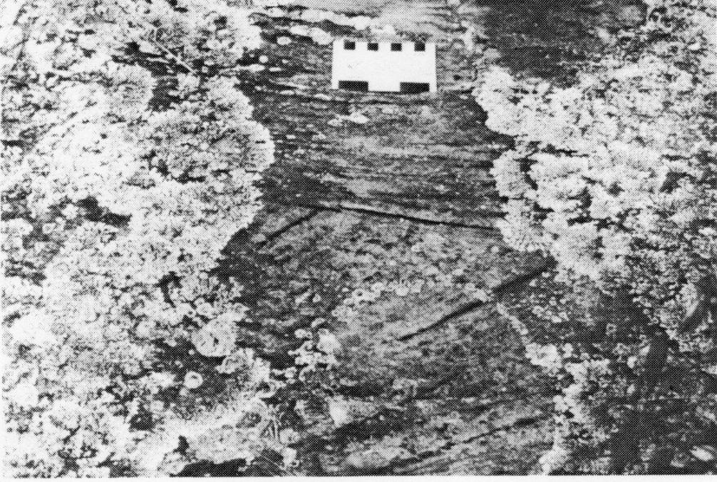
54 -28- Between 1917 and 1922 the property lay idle. The workings were dewatered in 1923 and limited development was carried out in From 1925 to 1926 the mine was dewatered again, a 125 foot winze was driven below the 400 foot level and minor drifting was undertaken on the 500 foot level. In 1928, the Bey Mines Limited acquired the property from the Ore Chimney Mining Company. In 1929 they drilled three holes from surface, totalling 2372 feet, one of which cut, at a depth of 605 feet, 7 feet (3.5 foot true width) assaying oz/ton Au, 7.8 oz/ton Ag, S.2% Pb and X.9% Zn. The mine was dewatered and thoroughly re-sampled in A cross cut was driven 100 feet south from the vein on the 400 foot level from where 1000 feet of drilling was completed in three holes. As of 1932 development work in the form of crosscuts, drifts and winzes totalled 2554 feet (779 m) and estimated ore reserves totalled 11,000 tons grading 0.20 oz/ton Au and 5.64 oz/ton Ag between the 100 and 500 foot levels (Source Mineral Deposit Files, Ontario Geological Survey, Toronto). Mr. R.W. Clark acquired the property via a mortgage foreclosure on the Bey Mines in 1941 and during the period 1941 to 1943 the Webbwood Copper Mining Syndicate Limited, by arrangement in Mr. Clark, unsuccessfully attempted to dispose of the lead and zinc from the mine dump. East Webb Mines Limited was formed in 1944 to acquire title to the
55 -29- property. Little work was carried out until 1956 when the assets of East Webb Mines were acquired by the Cavalier Mining Company Limited who drilled 8 surface diamond drill holes totalling 4667 feet in an attempt to intersect the north east extension of the vein.. Three of these holes were cross cut core lengths of 2.0 feet or less of material carrying values of interest. In 1961 the charter of Cavalier Mining Company was cancelled and little is known of the disposition of the property until 1977 when a Mr. Gale brought the property to lease. At the present time the Ore Chimney Mine property is owned by Mr. A. Banner of Cloyne, Ontario. During 1983 Mr. Banner dewatered the workings to the 150 foot level to resample. This level was briefly open for inspection during August Detailed Geology The gold-silver-copper-lead-zinc mineralization occurring at the Ore Chimney Mine is hosted in a quartz-vein system localized within sheared hornblendebiotite-garnet schist (Ore Chimney Formation) near the contact between underlying mafic metavolcanics of the Tudor Formation and unconformably overlying quartzite and quartz-pebble conglomerate of the Bishop Corners Formation, Flinton Group. During the present survey a 600 m strike length of the area in the immediate vicinity of the shaft was mapped at
56 -30-1:2000 scale on 50 m spaced lines. A base line was run in along strike within mafic metavolcanics north of the shaft and cross lines were run south from the base line across the contact and well into the overlying metasediments. The general geology of the Ore Chimney property (Figure 4) shows mafic metavolcanics to the northwest overlain by mafic metasediments, quartzite and quartzite- pebble conglomerate to the southeast. The central part of the volcanic-sediment contact zone forms an S-shaped pair of folds whose axial plane appears parallel to the regional foliation trend. The main shaft of the property is situated near the apex of this fold (Figure 4). All rocks exposed on the property are moderately to well-foliated on planes trending OSO 0 to and dipping steeply (075 0 to ) to the north. Primary structures have been preserved particularly in pillowed mafic metavolcanics and well cross-bedded quartzites. Pillow structures northwest of the shaft indicate flow tops face to the northwest. Cross-bedding preserved within Flinton Group meta-quartzites indicate tops to the southeast, so that across the unconformity the units are back to back. Minor S-folding occurs within metasedimentary units in the south part of the property. Their axial planes trend parallel to the regional foliation directions trending 050 to and they plunge steeply (065 to OSO 0 ) to the northeast. No faulting was observed to offset units on the
57 -31- FLINTON GROUP Bishop Corners Formation 6 Muscovite schist 5 Micaceous gritty quartz pebble conglomerate, quartzite 4 Quartzite pebble conglomerate 3 Quartzite SITE OF OLD MILC 85t Ore Chimney Formation 2 Horneblende-biotitegarnet schist HERMON GROUP Tudor Formation 1 Amphibolite, amphibolite gneiss d Building, foundation Trench waste dump contact Syncline, inferred r^ Anticline, inferred NX Foliation. inclined, vertical Bedding, inclined Plunge, fold axes Plunge, pebbles in cgl. Pillow, top indicated 50 IOO met res Figure 4: Geology of the Ore Chimney Mine Area, Barrie Township, Southeastern Ontario.
58 -32- property. Swampy ground in the west central part of the property obscures the contact relationships between the volcanics and clastic rocks. Description of Units a. Tudor Formation The mafic metavolcanic rocks exposed on the Ore Chimney mine property are fine-grained, dark green-grey to black, moderately well foliated to fissile amphibolites. Occasional pillow structures are seen stretched parallel to the regional foliation direction (Plate 4). Top directions face northwest. One to two metre interbeds of andesitic tuffaceous material, within the predominantly mafic volcanic section, appear light to medium-grained-grey and are laminated parallel to foliation. Moore and Morton (1980) report lapilli tuff horizons within the volcaniclastic rocks however no fragments were observed during the present survey. The mafic metavolcanic rocks are often cut by fine (0.5 to 2 mm) cross fractures infilled with quartz and quartz-carbonate. Smears of carbonate occur along foliation planes particularly in the vicinity of the shaft. Accessory fine-grained disseminated pyrite and magnetite were observed sporadically within the amphibolites.

59 -33- Plate 4: Pillows in mafic metavolcanics of the Tudor Formation, Ore Chimney Property.
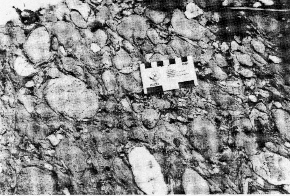
60
61 -34- b. Ore Chimney Formation At or near the contact with the overlying Flinton Group metaclastic rocks is a 0.5 to 4 m wide zone of magnetic biotite-garnet schist (Ore Chimney Formation, Moore and Morton 1980). This unit, which hosts the gold-base metal quartz veins on the property, is poorly exposed on surface and its distribution is approximated from minor exposures south of the main shaft and from underground (150 feet level, 10 m east of the shaft and along the 150 drift to the west). This unit is fine to medium grained, dark grey to black and is composed of well foliated to sheared biotite with 2-10% disseminated (<l mm) magnetite grains and S-10%, -.2 to l cm red garnet porphyroblasts. Minor constituents include quartz, plagioclase, carbonate and hornblende. chloritization of biotite was observed. Minor c. Bishop Corners Formation, Flinton Group Unconformably overlying the Tudor and Ore Chimney Formations is a sequence of quartzite and quartzite-pebble conglomerate. The base of this metaclastic sequence is a 5-10 m thickness of medium-grained buff tan to light grey, well laminated and massive quartzite. Well preserved cross beds are characteristic, indicated by dark reddish-grey laminations marking cross bed forsets (Plate 5). This unit is composed almost entirely of medium grained quartz with minor accessory muscovite, kyanite, hematite and tourmaline (Moore and Morton 1980).
62
63 -35- Plate 5: Cross bedded quartzites at the base of the Bishop Corners Formation, Ore Chimney property
64
65 --36- In sharp contact with and immediately overlying the quartzite is a thick section of quartzite-pebble conglomerate with minor interbeds of quartzite and micaceous quartzite. The conglomerate contains 60 to 8(^ quartzite, quartz and black chert clasts (2-25 cm long) in a buff-tan micaceous quartzite matrix. Most of the clasts are buff tan to light grey quartzite with fine hematitic laminations and relict cross-beds similar to the underlying quartzite. Auxiliary clasts include white "vein" or massive quartz, black fine-grained cherty quartzite and rarely dark green to black amphibolite fragments. The conglomerate is well foliated and the clasts are elongated (in plan) parallel to the regional foliation direction (Plate 6). In section the clasts within the conglomerate have their longest dimension plunging steeply to the north east to east. They both parallel the foliation trend and plunge parallel with minor fold structures on the property. The conglomerate unit is 40 to 100 m thick. To the south and east, up section, it is interbedded with increasing amounts of micaceous quartzite, muscovite schist and a gritty quartz-pebble conglomerate. The latter two units appear to overlie the conglomerate in the mine area. The gritty conglomerate contains 10 to BO^fe quartzite and quartz pebbles (1-3 cm long) in a medium-grained micaceous quartzite matrix. Contacts between all metaclastic units are sharp and detailed facies relationships are unclear.
66

67 -37- Plate 6: Stretched pebbles in Bishop Corners Formation conglomerate, Ore Chimney Property.
68
69 -38- Mineralization The mineralized shear zone at the Ore Chimney mine is not exposed at surface however dump material and exposure in the main drift at the 150 foot level underground were examined. Further data on ore zone dimensions and grades have been summarized from old company files (John Malczak, Ontario Geological Survey, 1984). The mineralization at the Ore Chimney mine occurs in a system of quartz stringer veins hosted in sheared garnetbiotite schist, the Ore Chimney Formation. Inspection of the underground workings (150 feet level) has shown the mineralization to be associated with narrow (1-10 cm) discontinuous quartz-carbonate stringers within a sheared biotite schist. Sulphide mineralization occurs as dissemination and pods concentrated along quartz vein margins and disseminated within host rocks between quartz stringers. Minor short discontinuous cross-fractures, trending 300 to 320 0, appear to offset the quartz stringers a few centimetres. Sulphide minerals observed within the mineralized shear zone include pyrite, sphalerite, galena and chalcopyrite. Trace amounts of tetrahedrite were observed in mineralized dump material. Gold is reported to occur free in quartz gangue (Meen 1942). Table II is a summary of the dimensions and grade of the mineralization taken from the Prospectus of the Cavalier Mining Company (Campbell 1957).
70 -39- TABLE II Summary of the Ore Shoot as indicated by underground samplings Mine Level Length Feet Width Feet oz/ton % Au Ag Pb Zn Winze 605' DDK # This summary suggests that the ore zone is a vertical pipe or shoot which appears to increase in width and grade with depth. The intersection of good grade material over widths of 3.25 feet even at depths of 604 feet indicates a potentially untested depth extent to the ore shoot. Estimates of ore reserves as of 1957 include tons grading 0.20 oz/ton Au and 5.64 oz/ton Ag from 50 feet above the 150 foot level to 50 feet below the 500 foot level (Campbell 1957). Summary The mineralized quartz vein system at the Ore Chimney mine is hosted in a shear zone which is conformable with the regional foliation trend but discordant to the Flinton stratigraphy and its basal unconformity. The shear zone has formed within a biotite-garnet schist unit, the Ore Chimney Formation, which lies below the unconformity. The quartz veins are conformable with the schistosity of the sheared biotite-garnet schist.
71 -40- Sulphide mineralization in the form of pyrite, chalcopyrite, sphalerite and galena occurs as irregular pods and disseminations along quartz-vein boundaries and as disseminations within the biotite-garnet schist host rocks. Gold mineralization is reported to occur free in quartz-gangue (Meen 1942). The outcrop distribution near the main shaft indicates the presence of a fold with the shaft having been sunk in mineralization at its closure. Poor surface and underground exposure of the mineralized shear zone provided insufficient data to determine the importance of this fold closure in concentrating the mineralization. Descriptions of mineralization exposed in underground workings and data from assay plans and surface and underground diamond drilling indicate a flattened, lens-shaped mineralized zone conformable to the regional foliation trends. The known mineralized zone, containing an estimated tons grading 0.20 oz/ton Au and 5.64 oz/ton Ag, appears open at depth; gold values increase whilst silver values decrease with depth (Campbell 1957). The bulk of the exploration and development work reported to have been undertaken on the property has been concentrated within a limited area northeast of the shaft site for a distance of 500 feet. Potential exists for further mineralization down dip from the main zone and within the favourable Ore Chimney Formation to the southwest and further north east of the main shaft.
72 -41- Although the reported mineralization contained within the presently explored and developed area around the shaft is limited, further systematic exploration of strike extension of the sheared Ore Chimney Formation could outline additional tonnage. Ore Mountain Occurrence: Lot 32, Concession I, Barrie Township Introduction The Ore Mountain Occurrence is located in lot 32, Concession I, Barrie Township, Frontenac County. Access to the property is via a small bush road which runs south off the Harlowe road approximately 3 km east of Highway 41 (Fiq. 1), NTS 31C/14. The occurrence, approximately 1.5 kilometres east along strike from the Ore Chimney Mine, lies in a similar structural and stratigraphic setting. It was briefly inspected for comparison with the Addington and Ore Chimney properties. History of Development Ore Mountain Mine Limited was incorporated in 1914 and, at this time, it acquired the mining rights to Lot 32, Concession I, Barrie Township (Sutherland et al. 1915). A small shallow shaft was sunk and several exploration pits were excavated (Meen 1942). No further work has been recorded on the property to the present time and control of the mining rights are unknown.
73 -42- FLINTON GROUP Bishop Corners Formation 6 Muscovite schist 5 Micaceous gritty quartz pebble conglomerate, quartzite 4 Quartzite pebble conglomerate 3 Quartzite UNCONFORMITY ~~ Ore Chimney Formation 2 Homeblende-biotite* garnet schist HERMON GROUP Tudor Formation 1 Amphibolite, amphibolite gneiss Ta Trench ^C^r Ore waste dump \Geological contact XX. Foliation. inclined, vertical so 100 metres Figure 5: Geology of the Ore Mountain Occurrence, Barrie Township, Southeastern Ontario.
74 -43- Detailed Geology The mineralization exposed on the Ore Mountain property consists of pyrite and minor arsenopyrite associated with a narrow zone (0.5 to 1.5 m) of quartz stringer veins hosted in a dark grey to black amphibole-biotite schist (Fig. 5). The quartz veins and the well-developed foliation within the schist host rocks trend parallel to the regional foliation directions which trend (070 to ) and 70 to 85 0 north. At the main shaft site, discontinuous quartz stringers, 2-8 cm wide are exposed across approximately l m in the shaft. The host rocks appear to become more micaceous in the footwall of the veins whereas the hanging wall consists of an amphibolite showing relict feldspar porphyroblasts. Pyrite, arsenopyrite and minor magnetite are disseminated within the hornblende-biotite schist with lesser amounts of pyrite and traces of magnetite disseminated in the amphibolite hanging wall of the trench. No gold was visible in the trench material. Although pyrite and arsenopyrite are disseminated in host and wallrocks much of it is localized along margins of quartz stringers within the sheared hornblende-biotite schist. Description of Units a. The Tudor Formation The mafic metavolcanics exposed on the property consist of fine-grained, dark green, well foliated
75 -44- amphibolite commonly showing a gneissic texture with irregular segregation of mafic and lesser felsic quartz-plagioclase phases aliened parallel to regional foliation. Minor carbonate in the amphibolite occurs as fine fracture infillings with quartz or as smears along foliation planes. This unit contains minor zones of fine disseminated pyrite. In the vicinity of the quartz veins exposed in the main shaft area the amphibolite becomes well foliated to schistose in texture and zones containing feldspar porphyroblasts occur apparently interbedded with the more schistose varieties. b. Ore Chimney Formation The amphibole-biotite schist of the Ore Chimney Formation is best exposed in the two pits near the east end of the property. Other minor exposure of amphibole-biotite schist along strike and to the west of these exposures indicate the presence of this formation along the contact between the underlying Tudor Formation and overlying Flinton Group. Where well exposed this unit is 1-2 m thick and appears to grade, to the north, into amphibolite schist and to the south into micaceous quartzite of the Flinton Group. In the vicinity of the main shaft this unit hosts numerous.5 to 2 cm discontinuous quartz stringers which contain pyrite and minor arsenopyrite as disseminations along vein margins. Pyrite and arsenopyrite are also documented within amphibole-biotite schist between quartz
76 -45- veins. Minor traces of pyrite are disseminated within amphibolite in contact with the mineralized zone. The quartz veins are conformable with regional foliation and have formed within minor dilatant zones resulting from shearing of the Ore Chimney Formation. c. Bishop Corners Formation, Flinton Group Immediately overlying the Ore Chimney Formation as a 3 to 10 m thick section of fine to medium-grained, buff tan, grey to pinkish grey well laminated and occasionally cross-bedded micaceous quartzite. Cross beds indicate that bedding faces south. Within this quartzite are cm thick interbeds of medium to coarse grained gritty sandstone which contain up to 20% quartz pebbles l to 3 cm in size. This gritty unit is medium to dark grey, well foliated and contains up to 10% biotite. Stratigraphically above the micaceous quartzite to the south is a sequence of quartz to quartzite-pebble conglomerate typical of Flinton Group conglomerates. It contains 40 to 80% clasts of quartzite and white, milky quartz, 2-25 cm long in a buff-tan micaceous quartzite matrix. This unit is well foliated with the pebbles elongated parallel to the regional foliation direction (080 0 ). Detailed Structure All units exposed on the Ore Mountain Property exhibit a well-developed foliation trending to OSO 0 and
77 -46- dipping steeply to the north (75 0 to 90 0 ). Bedding attitudes of the Flinton group taken from preserved cross beds within quartzite indicate trends of 080 to and dips moderate to the south. Cross beds also indicate that the Flinton group metaclastics face south. Faulting as indicated by shear zones within the Ore Chimney Formation parallels regional foliation trends. Type and sense of movement are not clear. No cross-faulting or bed offsets were observed. Minor folding was observed within quartzite pebble conglomerates near the south boundary of the map area. Axial traces of these folds trend and plunge moderately (50 to 60 0 ) to the east. Mineralization Fine to medium-grained pyrite, arsenopyrite and minor to trace amounts of magnetite are associated with a narrow ( m) zone of quartz stringer veins hosted in sheared amphibolite-biotite schist. The sulphides, which comprise up to 10% of the zone in places, are discrete disseminated grains hosted in the amphibole-biotite schist with minor concentrations along quartz vein margins. No gold mineralization was observed nor have any values been reported to have come from this property. Summary Pyrite, arsenopyrite and minor magnetite mineralization are hosted in a narrow quartz stringer vein
78 -47- zone in sheared amphibole-biotite schist of the Ore Chimney Formation just below the contact of the overlying Flinton Group. The structural and stratigraphic setting of this mineralization resembles that of the Addington and Ore Chimney properties although the extent of shear zone development, quartz vein formation and associated sulphide gold concentration appears to be less. However, the brief investigation of the setting of the mineralization at the Ore Mountain property has provided further data on the favourability of the Ore Chimney Formation to host quartz vein systems and sulphide -H gold mineralization. It appears more evident that this Formation, where it has become sheared, may be a regional metallogenetic target formation for exploration for Au*Ag base metal vein systems. GENERAL SUMMARY The mineralized quartz vein systems at the Addington, Ore Chimney and Ore Mountain occurrences are hosted in a sheared biotite-garnet schist unit called the Ore Chimney Formation. This formation occurs at the base of the Flinton Group and commonly contains conformable quartz stringer veins which parallel the major post-flinton regional foliation. Extensive shearing at the base of the Flinton Group, resulting from competency differences between the underlying metavolcanics and overlying quartzite and conglomerate, has created dilatant zones into
79 -48- which metamorphically derived mineralizing solutions migrated and deposited quartzite veins, sulphides and Au. The dilatancy and shearing may have been enhanced by the presence of the Ore Chimney Formation along this contact or the Ore Chimney Formation may simply be the end product of the shearing itself. Field and petrographic studies suggest to Moore and Morton (1980) that the Ore Chimney Formation is a separate stratigraphic unit which was laid down as a mafic sediment overlying the Tudor mafic metavolcanics prior to Flinton sedimentation. This formation has been mapped intermittently for over 40 kilometres along the base of the Flinton Group between Flinton and Bishop Corners (Moore and Morton 1980). During the present study, the Ore Chimney Formation was consistently observed at the Tudor-Flinton contact and appears to have been repeated across fold structures. Bell (1949) documented the presence of a biotite-garnet schist in outcrop around a small synclinal infold of Flinton elastics within the Tudor metavolcanics in the north central part of the Addington property. The present survey located intermittent outcrops of this formation in the same area. Bell (1979) also noted a thickening of the Ore Chimney Formation at the nose of this small syncline. This fact could not be substantiated during the present survey due to poor exposure in low swampy ground south of the small syncline.
80 -49- Wherever exposed, the Ore Chimney Formation is extensively sheared and its thickness is extremely variable. In the main shear zone at the Addington property the Ore Chimney Formation varies from 2 to 10 m thick. The lensoid configuration of the formation could be due to extension during shearing so that any original variation in thickness has been obscured. An alternative hypothesis regarding the development of the Ore Chimney Formation is that it is the result of extensive shearing along the Tudor-Flinton contact. The consistent location of the development of this biotitegarnet schist at or near the aforementioned contact, its well-developed schistosity which conforms to the major post-flinton regional foliation and the consistent presence of quartz veins suggests that the Ore Chimney Formation's development may have coincided with the major post-flinton regional metamorphic event. The intersection of this unit within Lower Flinton Group micaceous quartzites in drill holes transecting the Tudor/Flinton contact further suggests that this Formation is not a distinct stratigraphic unit but is the result of extensive shearing and alteration near the Tudor-Flinton contact during regional metamorphism (Wayne Johnson, Consultant Geologist, Addington Mines Ltd., personal communication, 1984). For exploration purposes we have two possible scenarios with which to model the formation of these deposits.
81 -50-1) The Ore Chimney Formation was laid down as a mafic sediment resulting from the weathering of underlying mafic volcanics of the Tudor Formation. Metaclastic sediments of the Flinton Group were unconformably deposited above this formation and during post Flinton regional metamorphism extensive shearing due to a competency differential between the two units was localized along the Tudor-Flinton unconformity. The presence of the more ductile Ore Chimney Formation, permitted more extensive shearing and dilatancy. Metamorphically derived hydrothermal fluids migrated into this dilatant zone and deposited conformable quartz veins with associated base metals and gold, or 2). During post-flinton regional metamorphism shear stress was dissipated along the Tudor-Flinton contact due to competancy differences between the two units. The upper part of the Tudor mafic metavolcanics became sheared and altered by metamorphically derived hydrothermal solutions which had migrated into dilatant zones formed along this deformation. Potassic alteration resulted in extensive biotite development which enhanced shearing and dilatancy. The conformable mineralized quartz veins were formed within dilatant zones resulting from shearing and alteration. It is evident, from either scenario, that the major post-flinton metamorphic and structural event resulted in the formation of these conformable quartz vein systems. At the Addington property the major shear zone system is host to 4 separate ore zones (Bell 1949). These zones are
82 -51- pipe-like in shape with their lona dimension on the down-dip direction and individual zones plunge steeply to the south (W. Johnson, Consultant Geologist, Addington Mines Ltd., personal communication, 1984). The long dimension of deformed quartz pebbles in the Flinton conglomerates and the axial traces of minor folds as indicated by deformed pebbles within the conglomerates also plunge steeply to the south. The concentration of zones of higher grade mineralization within a major linear shear structure suggests that additional structural controls were in effect during fluid migration and mineral deposition which has resulted in select areas of increased dilatancy and permeability. In cross section the plane of the shear zone dips more steeply than the bedding planes within the Flinton sediments. The intersection of these two planes roughly parallels the plunge of the ore zones which suggests that a certain component of the shear stress was dissipated in this direction resulting in the present pipe-like ore zone configuration. Detailed diamond drill hole information in the form of longitudinal and cross sections through the ore zones would be useful in fully defining the structural controls of these ore zones. CONCLUSIONS The mineralized quartz veins exposed at the Addington Ore Chimney and Ore Mountain occurrences are conformable with the major post-flinton regional foliation. As well,
83 -52- minor gold bearing quartz veins occur within Flinton group clastic metasediments at the Addington Mine, thus suqaestinq that the mineralization formed in post-flinton time. The localization of these shear zone hosted deposits near the basal Flinton unconformity is due to competency differences between lower Tudor metavolcanics and upper Flinton metaclastics whereby this contact has acted as a structural break along which shearing developed during post-flinton regional metamorphism. The association of the more extensive quartz vein systems within the biotite-garnet schist of the Ore Chimney Formation, has been well documented. Although the timing of the formation of this unit remains somewhat enigmatic, its presence appears to be critical for extensive quartz vein development. Detailed mapping of exposures of this unit should be of high priority in prospecting for these deposit types. The almost ubiquitous association of fine-grained disseminated magnetite within this unit avails the use of regional and detailed ground magnetometer surveys in defining initial favourable exploration areas.
84 -53- REFERENCES Bell, L.V. 1949: Geological Report, Addington Mines Ltd., From Private Company Files, Cominco Ltd. Campbell, C.A. 1957: Report to the President and Directors of the Cavalier Mining Corporation Ltd. on the Ore Chimney Property, Files of J. Malczak, Ontario Geological Survey. Harding, W.D. 1942: Geology of the Kaladar and Kennebec Townships, Ontario Department of Mines, Vol. 51, Part 4, p Lumbers, S.B. 1969: Geology of Limerick and Tudor Townships; Ontario Department of Mines, Geological Report 67, HOp. Malczak, J. 1984: Files of Base and Precious Metals Occurrences in the Kingston Sheet (NTS 31). Meen, V.B. 1942: Geology of the Grimsthorpe-Barrie Area; Ontario Department of Mines, Vol. 51, Pt. 4, p Mineral Deposits Files, Ontario Geological Survey, 77 Grenville Street, Toronto. Moore, J.M. Jr. and Morton, R.L. 1980: Geology of the Clarendon Lake Area,Counties of Frontenac and Lennox and Addington; Ontario Geological Survey, Open File Report Moore, J.M., Jr. and Thompson, P.H. 1980: The Flinton Group: A Late Precambrian Metasedimentary Succession in the Grenville Province of Eastern Ontario; Canadian Journal of Earth Sciences, Vol. 17, p Springer, J.S. 1982: Gold and Base Metal Vein Deposits in Eastern Ontario - Structural Inferences and the Significance of Vein Mineralogy; Ontario Geological Survey, Miscellaneous Paper 106, 235p.
85 -54- Sutherland, T.F, Collins, E.A., McMillan, J.G. and Bartlett, J. 1915: Mines of Ontario, Report on the Ore Mountain Property; Ontario Bureau of Mines, Vol. XXIV, Part l, p.161. Thompson, P.H. 1972: Stratigraphy, Structure and Metamorphism of the Flinton Group in the Bishop Corners - Madoc Area, Grenville Province, Eastern Ontario; Unpublished Ph.D. Thesis, Carleton University. Wolff, J.M. 1982: Geology of the Kaladar Area, Frontenac and Lennox and Addington Counties; Ontario Geological Survey, Report 215, 94p. Accompanied by Map 2342, Scale 1:31680.
86
87
88
89
90
91
92
The MAPLE BAY PROJECT Copper Silver - Gold
 The MAPLE BAY PROJECT Copper Silver - Gold Good grade and tonnage potential within close proximity to Tidewater The Maple Bay Copper Silver Gold Project covers highly favourable geological host rocks of
Mishi Lake Gold Property Mishibishu Lake Area, Wawa
 Mishi Lake Gold Property Mishibishu Lake Area, Wawa Location, Accessibility, Infrastructure and Local Resources The property is located 40 km west of Wawa, Ontario, in the Mishibishu Lake Area, Sault Ste.
THESE TERMS GOVERN YOUR USE OF THIS DOCUMENT
 THESE TERMS GOVERN YOUR USE OF THIS DOCUMENT Your use of this Ontario Geological Survey document (the Content ) is governed by the terms set out on this page ( Terms of Use ). By downloading this Content,
Local: (705) Toll Free: , ext (inside Canada, United States) Local: (705) Toll Free: , ext.
 Toll Free: , ext (inside Canada, United States) Local: (705) Toll Free: , ext.") THESE TERMS GOVERN YOUR USE OF THIS DOCUMENT Your use of this Ontario Geological Survey document (the Content ) is governed by the terms set out on this page ( Terms of Use ). By downloading this Content,
THESE TERMS GOVERN YOUR USE OF THIS DOCUMENT Your use of this Ontario Geological Survey document (the Content ) is governed by the terms set out on this page ( Terms of Use ). By downloading this Content,
MRD 281. Official Name of the Data Set or Information Holding: Northeastern Ontario Rhyolite Database
 MRD 281 GENERAL INFORMATION Official Name of the Data Set or Information Holding: Northeastern Ontario Rhyolite Database Acronyms are Used to Identify the Data Set or Information Holding: MRD281 Describe
Local: (705) Toll Free: , ext (inside Canada, United States) Local: (705) Toll Free: , ext.
 Toll Free: , ext (inside Canada, United States) Local: (705) Toll Free: , ext.") THESE TERMS GOVERN YOUR USE OF THIS DOCUMENT Your use of this Ontario Geological Survey document (the Content ) is governed by the terms set out on this page ( Terms of Use ). By downloading this Content,
THESE TERMS GOVERN YOUR USE OF THIS DOCUMENT Your use of this Ontario Geological Survey document (the Content ) is governed by the terms set out on this page ( Terms of Use ). By downloading this Content,
MRD283-REV METADATA. Acronyms are Used to Identify the Data Set or Information Holding: MRD283-REV
 MRD283-REV METADATA GENERAL INFORMATION Official Name of the Data Set or Information Holding: Ambient Groundwater Geochemistry Data for Southern Ontario, 2007 2014 Acronyms are Used to Identify the Data
We are committed to providing accessible customer service. If you need accessible formats or communications supports, please contact us.
 We are committed to providing accessible customer service. If you need accessible formats or communications supports, please contact us. Nous tenons à améliorer l accessibilité des services à la clientèle.
Local: (705) Toll Free: , ext (inside Canada, United States) Local: (705) Toll Free: , ext.
 Toll Free: , ext (inside Canada, United States) Local: (705) Toll Free: , ext.") THESE TERMS GOVERN YOUR USE OF THIS DOCUMENT Your use of this Ontario Geological Survey document (the Content ) is governed by the terms set out on this page ( Terms of Use ). By downloading this Content,
THESE TERMS GOVERN YOUR USE OF THIS DOCUMENT Your use of this Ontario Geological Survey document (the Content ) is governed by the terms set out on this page ( Terms of Use ). By downloading this Content,
Amador Canyon Silver Mining Property Lander County, NV
 Amador Canyon Silver Mining Property Lander County, NV Over $1 million worth of exploration and evaluation work performed Favorable drill results including a return of 286 g/ton silver over 12.2 meters
MRD273-REV METADATA. Acronyms are Used to Identify the Data Set or Information Holding: MRD273-REV
 MRD273-REV METADATA GENERAL INFORMATION Official Name of the Data Set or Information Holding: Ontario Precambrian Bedrock Magnetic Susceptibility Geodatabase for 2001 to 2012 Acronyms are Used to Identify
AGGREGATE RESOURCES OF ONTARIO (ARO) METADATA
 METADATA") AGGREGATE RESOURCES OF ONTARIO (ARO) METADATA GENERAL INFORMATION Official Name of the Data Set or Information Holding: Aggregate Resources of Ontario Acronyms are Used to Identify the Data Set or Information
AGGREGATE RESOURCES OF ONTARIO (ARO) METADATA GENERAL INFORMATION Official Name of the Data Set or Information Holding: Aggregate Resources of Ontario Acronyms are Used to Identify the Data Set or Information
GEOLOGY OF THE NICOLA GROUP BETWEEN MISSEZULA LAKE AND ALLISON LAKE
 GEOLOGY OF THE NICOLA GROUP BETWEEN MISSEZULA LAKE AND ALLISON LAKE (92H/15E. 10E1 By V. A. Preto INTRODUCTION Mapping was continued southward from the area covered in 1973 and an additional 55 square
GEOPHYSICAL DATA SET (GDS) 1084B METADATA
 1084B METADATA") GEOPHYSICAL DATA SET (GDS) 1084B METADATA GENERAL INFORMATION Official Name of the Data Set or Information Holding: Ontario Airborne Geophysical Surveys, Magnetic Gradiometer and Gamma-Ray Spectrometric
GEOPHYSICAL DATA SET (GDS) 1084B METADATA GENERAL INFORMATION Official Name of the Data Set or Information Holding: Ontario Airborne Geophysical Surveys, Magnetic Gradiometer and Gamma-Ray Spectrometric
The Cobalt Rainbow. Airborne geophysical maps show that a north trending aeromagnetic high suggests further undiscovered mineralisation.
 The Cobalt Rainbow The property is located on Greenstone Creek, approximately 4.8 kilometres south west of the creek mouth. The property is located about 24 km due west of Campbell River, in the east-central
THESE TERMS GOVERN YOUR USE OF THIS DOCUMENT
 THESE TERMS GOVERN YOUR USE OF THIS DOCUMENT Your use of this Ontario Geological Survey document (the Content ) is governed by the terms set out on this page ( Terms of Use ). By downloading this Content,
MRD 229-Revised METADATA
 GENERAL INFORMATION MRD 229-Revised METADATA Official Name of the Data Set or Information Holding: Till Compositional Database: Investigation of the Overburden Signature of the Caribou Lake Greenstone
THESE TERMS GOVERN YOUR USE OF THIS DOCUMENT
 THESE TERMS GOVERN YOUR USE OF THIS DOCUMENT Your use of this Ontario Geological Survey document (the Content ) is governed by the terms set out on this page ( Terms of Use ). By downloading this Content,
Queensland Mining Corporation Limited
 Queensland Mining Corporation Limited ABN 61 109 962 469 ASX Release 29 th July 2011 Drilling Commenced at Duck Creek Copper-Gold Project, Cloncurry, North-west Queensland Highlights RC drilling has commenced
THESE TERMS GOVERN YOUR USE OF THIS DOCUMENT
 THESE TERMS GOVERN YOUR USE OF THIS DOCUMENT Your use of this Ontario Geological Survey document (the Content ) is governed by the terms set out on this page ( Terms of Use ). By downloading this Content,
MRD 207 METADATA DETAIL PAGE
 MRD 207 METADATA DETAIL PAGE The following represents the Basic description of an information holding. To obtain more information about this holding, see the section named Contacts. GENERAL INFORMATION
Drill locations for the 2015 program are highlighted in the geology map below.
 2015 Exploration Program The exploration program plan at KSM for 2015 was designed to improve the understanding of block cave targets and support engineering/environmental aspects of development scenarios.
Nickel Division - Sudbury Operations
 * *-.. FALCONBRIDGE NICKEL MINES LIMITED Nickel Division - Sudbury Operations Falconbridge, Ontario 002261 GRAHAM 010 GEOLOGY OF TllE NORTH QUARTER OP LOT 2, CON. IV, GRAHAM TOWNSHIP, DISTRICT OP SUDBURY,
DISCOVERY OF MINERALISED PORPHYRY & MAGNETITE-COPPER-GOLD AT KAMARANGAN
 MEDUSA MINING LIMITED ABN: 60 099 377 849 Unit 7, 11 Preston Street Como WA 6152 PO Box 860 Canning Bridge WA 6153 Telephone: +618-9367 0601 Facsimile: +618-9367 0602 Email: admin@medusamining.com.au Internet:
We are committed to providing accessible customer service. If you need accessible formats or communications supports, please contact us.
 We are committed to providing accessible customer service. If you need accessible formats or communications supports, please contact us. Nous tenons à améliorer l accessibilité des services à la clientèle.
MRD 228 METADATA. Official Name of the Data Set or Information Holding: Physiography of Southern Ontario
 MRD 228 METADATA GENERAL INFORMATION Official Name of the Data Set or Information Holding: Physiography of Southern Ontario Acronyms are Used to Identify the Data Set or Information Holding: MRD228 Describe
THESE TERMS GOVERN YOUR USE OF THIS DOCUMENT
 THESE TERMS GOVERN YOUR USE OF THIS DOCUMENT Your use of this Ontario Geological Survey document (the Content ) is governed by the terms set out on this page ( Terms of Use ). By downloading this Content,
THESE TERMS GOVERN YOUR USE OF THIS DOCUMENT
 THESE TERMS GOVERN YOUR USE OF THIS DOCUMENT Your use of this Ontario Geological Survey document (the Content ) is governed by the terms set out on this page ( Terms of Use ). By downloading this Content,
GS-17. Summary. Previous work. Regional setting. Introduction. Geology
 GS-17 Geology, structure and mineralization of the Ore Fault property, Bird River greenstone belt, southeastern Manitoba (parts of NTS 52L5NE and 52L6NW) by L.A. Murphy 1 and P. Theyer Murphy, L.A. and
MEMO. TO: Dennis Lapoint CC: FROM: Eriaan Wirosono DATE: April, 20 th 2014 SUBJECT: Exploration activity report March-April 2014_EW
 TO: Dennis Lapoint CC: FROM: Eriaan Wirosono DATE: April, 20 th 2014 SUBJECT: Exploration activity report March-April 2014_EW MEMO 1. Highlights and Productivity Overview pan sampling on target Areas 1
Local: (705) Toll Free: , ext (inside Canada, United States) Local: (705) Toll Free: , ext.
 Toll Free: , ext (inside Canada, United States) Local: (705) Toll Free: , ext.") THESE TERMS GOVERN YOUR USE OF THIS DOCUMENT Your use of this Ontario Geological Survey document (the Content ) is governed by the terms set out on this page ( Terms of Use ). By downloading this Content,
THESE TERMS GOVERN YOUR USE OF THIS DOCUMENT Your use of this Ontario Geological Survey document (the Content ) is governed by the terms set out on this page ( Terms of Use ). By downloading this Content,
THESE TERMS GOVERN YOUR USE OF THIS DOCUMENT
 THESE TERMS GOVERN YOUR USE OF THIS DOCUMENT Your use of this Ontario Geological Survey document (the Content ) is governed by the terms set out on this page ( Terms of Use ). By downloading this Content,
Pahtavaara Drill Program Intersects 32.8 G/T Gold Over 2.0M And 2.1 G/T Gold Over 18.0M In The Karoliina Zone
 Page 1 of 6 a Pahtavaara Drill Program Intersects 32.8 G/T Gold Over 2.0M And 2.1 G/T Gold Over 18.0M In The Karoliina Zone Jan 11, 2017 Toronto, Ontario, Canada Listed: RUP-TSX-V January 10, 2017 Rupert
THESE TERMS GOVERN YOUR USE OF THIS DOCUMENT
 THESE TERMS GOVERN YOUR USE OF THIS DOCUMENT Your use of this Ontario Geological Survey document (the Content ) is governed by the terms set out on this page ( Terms of Use ). By downloading this Content,
=%REPORT RECONNAISSANCE OF CHISHOLM LAKE PROSPECT. October 25, 1977
 =%REPORT ON FIELD RECONNAISSANCE OF CHISHOLM LAKE PROSPECT October 25, 1977 Bruce D. Vincent Imperial Oil Limited, Minerals - Coal, CALGARY, ALBERTA CHISHOLM LAKE PROSPECT Introduction The Chisholm Lake
ATON RETURNS 22.2 METRES OF 2.77 GRAMS PER TONNE GOLD EQUIVALENT FROM HAMAMA WEST; VISIBLE GOLD DISCOVERED AT BOHLOG
 FOR IMMEDIATE RELEASE: ATON RETURNS 22.2 METRES OF 2.77 GRAMS PER TONNE GOLD EQUIVALENT FROM HAMAMA WEST; VISIBLE GOLD DISCOVERED AT BOHLOG Vancouver, April XX, 2017: Aton Resources Inc. (AAN: TSX-V) (
GEOLOGY OF THAILAND (METAMORPHIC ROCKS)
") GEOLOGY OF THAILAND (METAMORPHIC ROCKS) High-Grade Metamorphic Rocks (Precambrian?) Low-Grade Metamorphic Rocks (Lower Paleozoic) 1 THAILAND EXPLANATION Lower Paleozoic Rocks (Low Grade) Precambrian (?)
GEOLOGY OF THAILAND (METAMORPHIC ROCKS) High-Grade Metamorphic Rocks (Precambrian?) Low-Grade Metamorphic Rocks (Lower Paleozoic) 1 THAILAND EXPLANATION Lower Paleozoic Rocks (Low Grade) Precambrian (?)
EXPLORATION LICENCE SURROUNDING THE HISTORIC FALUN COPPER MINE GRANTED
 ASX ANNOUNCEMENT 30 August 2007 EXPLORATION LICENCE SURROUNDING THE HISTORIC FALUN COPPER MINE GRANTED The Drake-Zinifex Alliance application for an exploration licence that covers the historic Falun copper
DÉCOUVERTE Positioned for Discovery in James Bay, Quebec. Investor Presentation, January 2018 by Danae Voormeij, MSc, PGeo
 DÉCOUVERTE Positioned for Discovery in James Bay, Quebec Investor Presentation, January 2018 by Danae Voormeij, MSc, PGeo Location Maps and Infrastructure Location: Durango Resources 100% owned Découverte
BUREAU OF MINERAL RESOURCES GEOLOGY AND GEOPHYSICS.
 COMMONWEALTH OF AUSTRALIA. DEPARTMENT OF NATIONAL DEVELOPMENT. BUREAU OF MINERAL RESOURCES GEOLOGY AND GEOPHYSICS. RECORDS: 1962/33 GEOLOGY OF THE B.W. IRON CLAIM, HUNDRED OF WATERHOUSE, NORTHERN TERRITORY.
Report. Mining Claim SO Butt Township. District of Nipissing. Southern Ontario Mining District. Richard Keevil ~ Geologist. August 29,2006.
 Report On Mining Claim SO 1077365 Butt Township District of Nipissing Southern Ontario Mining District ~ "'_I ""'..1 D I..:"'.U&O... ~u ~]. Richard Keevil ~ Geologist August 29,2006. Richard R. Keevil,
Summary of Rover Metals Geologic Mapping Program at the Up Town Gold Project, Northwest Territories
 October 13, 2017 Summary of Rover Metals Geologic Mapping Program at the Up Town Gold Project, Northwest Territories Vancouver, British Columbia, Canada - Rover Metals Corp., Rover, is pleased to provide
PROSPECTING REPORT. Silver Dollar Property. EVENT # TENURE # Tenure Name: GPEX Silver Dollar
 2008-2009 PROSPECTING REPORT Silver Dollar Property EVENT # 4267989 TENURE # 555462 Tenure Name: GPEX Silver Dollar Similkameen Mining Division Map 092H Central Coordinate Reference 120 06 26.9 W Longitude
Lands Parcels in IOL CO-20
 Lands Parcels in IOL CO-20 1 CO-20 The Izok Corridor Lupin - multi-million ounce past gold production (3.6 million oz of gold at average grade of 9.3 g/t Au) Approximately 1 million ounces of undeveloped
CSA Mine Observations Applied to the Development of Regional Exploration Models
 CSA Mine Observations Applied to the Development of Regional Exploration Models 1 Introduction Recent work completed by the geology team has resulted in an improved understanding of the CSA mine system
ASX / MEDIA RELEASE 6 MAY MILE SILVER-LEAD-ZINC DISCOVERY; HIGH GRADE SILVER-GOLD IN ROCK CHIPS AT RUBY SILVER
 ASX / MEDIA RELEASE 6 MAY 2011 4-MILE SILVER-LEAD-ZINC DISCOVERY; HIGH GRADE SILVER-GOLD IN ROCK CHIPS AT RUBY SILVER Highlights: Silver-lead-zinc discovery at 4-Mile; mineralisation intersected in all
Local: (705) Toll Free: , ext (inside Canada, United States) Local: (705) Toll Free: , ext.
 Toll Free: , ext (inside Canada, United States) Local: (705) Toll Free: , ext.") THESE TERMS GOVERN YOUR USE OF THIS DOCUMENT Your use of this Ontario Geological Survey document (the Content ) is governed by the terms set out on this page ( Terms of Use ). By downloading this Content,
THESE TERMS GOVERN YOUR USE OF THIS DOCUMENT Your use of this Ontario Geological Survey document (the Content ) is governed by the terms set out on this page ( Terms of Use ). By downloading this Content,
THE GEOLOGY OF THE ENDEAVOR MINE: AN UPDATE
 THE GEOLOGY OF THE ENDEAVOR MINE: AN UPDATE Peter Nicholson, Vanadis Mares and Don Endeavor Operations Pty Ltd, via Louth Road, Cobar, NSW 2835. Key Words: zinc, lead, silver, Cobar, geology Introduction
BUREAU OF MINERAL RESOURCES GEOLOGY AND GEOPHYSICS,
 ^ ^c ^ / o/./ 3 4f c,3 COMMONWEALTH OF AUSTRALIA. DEPARTMENT OF NATIONAL DEVELOPMENT. BUREAU OF MINERAL RESOURCES GEOLOGY AND GEOPHYSICS, RECORDS. 1 960/134 GEOLOGY OF THE MAVIS TIN LEASE by P.G. Dunn.
POTENTIAL OF THE DONGWE COPPER GOLD PROJECT
 POTENTIAL OF THE DONGWE COPPER GOLD PROJECT By Nathan Sabao, P.Geo. September 2015 1 TABLE OF CONTENTS Page 1.0 EXECUTIVE SUMMARY 1 2.0 LOCATION 2 3.0 ACCESS 2 4.0 GEOLOGY 3 5.0 PREVIOUS DRILLING 5 6.0
SUMMARY HIGHL. The project is located close to road and gas pipeline infrastructure and a large service centre.
 INDEPENDENCE GROUP NL COMPANY DETAILS A SX A N NOUNCEMENT 2 1 s t JANUARY 2008 5 Pages IGO Acquires the Karlawinda Gold Project ASX CODE: IGO ABN: 46 092 786 304 DIRECTORS Rod Marston Non-Exec Chairman
We are committed to providing accessible customer service. If you need accessible formats or communications supports, please contact us.
 We are committed to providing accessible customer service. If you need accessible formats or communications supports, please contact us. Nous tenons à améliorer l accessibilité des services à la clientèle.
THESE TERMS GOVERN YOUR USE OF THIS DOCUMENT
 THESE TERMS GOVERN YOUR USE OF THIS DOCUMENT Your use of this Ontario Geological Survey document (the Content ) is governed by the terms set out on this page ( Terms of Use ). By downloading this Content,
SECOND DRILL HOLE IHAD2 INTERSECTS MINERALIZED TAPLEY HILL FORMATION AND MINERALIZED BASEMENT IRON FORMATION
 Suite 304, 22 St Kilda Road St Kilda Vic 3182 Ph: +61 3 9692 7222; Fax: +61 3 9529 8057 For Immediate Release 14 th September 2007 SECOND DRILL HOLE IHAD2 INTERSECTS MINERALIZED TAPLEY HILL FORMATION AND
GEOLOGICAL MAPPING OF SKARNS ON THE SHEEP AND EWE CLAIMS, TURNAGAIN RIVER, B.C. DURING THE 1979 SUMMER SEASON
 GEOLOGICAL MAPPING OF SKARNS ON THE SHEEP AND EWE CLAIMS, TURNAGAIN RIVER, B.C. DURING THE 1979 SUMMER SEASON CLAIMS: Sheep 1 to 4 Ewe 1, 3, 4 to 8 Lamb 12 Fraction Liard Mining Division, B.C. NTS 104
it AUSIMM COBAR MINING SEMINAR
 Straits Resources Limited it AUSIMM COBAR MINING SEMINAR Brownfields Exploration at Girilambone: Understanding the Mineralised Systems August 2010 Phil Shields / Phil Jones LOCATION TRITTON OPERATIONS
2. The latter two intersections occur outside the presently defined mineral resource.
 Avidian Drills 67 m of 4.93 g/t Au, includes 39.8 m of 7.54 g/t Au, at Golden Zone Property, Alaska & Discovers New Zone Northeast of the Breccia Pipe Deposit (Toronto, Ontario January 18, 2018) Avidian
We are committed to providing accessible customer service. If you need accessible formats or communications supports, please contact us.
 We are committed to providing accessible customer service. If you need accessible formats or communications supports, please contact us. Nous tenons à améliorer l accessibilité des services à la clientèle.
THESE TERMS GOVERN YOUR USE OF THIS DOCUMENT
 THESE TERMS GOVERN YOUR USE OF THIS DOCUMENT Your use of this Ontario Geological Survey document (the Content ) is governed by the terms set out on this page ( Terms of Use ). By downloading this Content,
MORE HIGH-GRADE GOLD INTERSECTIONS FROM CITADEL S SHAYBAN PROJECT, SAUDI ARABIA
 Citadel Resource Group Limited ASX Release 7th July 2009 MORE HIGH-GRADE GOLD INTERSECTIONS FROM CITADEL S SHAYBAN PROJECT, SAUDI ARABIA Highlights: LATEST RC IN-FILL AND EXTENSIONAL DRILLING CONTINUES
Queenston intersects Contact Zone on the Pandora Property and new gold zones in Kirkland Lake
 1 Queenston intersects Contact Zone on the Pandora Property and new gold zones in Kirkland Lake TORONTO, Ontario, March 7, 2003. Queenston Mining Inc. (QMI-TSX) reports diamond drill results on its 100%
CARIBOO - GRIZZLY ZINC PROJECT
 CARIBOO - GRIZZLY ZINC PROJECT The Grizzly Lake or Cariboo Zinc property straddles the gravel Weldwood 8400 logging road in the Grizzly Lake area about 55 kilometres northeast of Likely. Roads constructed
OSISKO INTERSECTS 37.0 g/t Au OVER 5.4 METRES AT OSBORNE-BELL Infill Drilling Continues to Confirm High-Grade
 OSISKO INTERSECTS 37.0 g/t Au OVER 5.4 METRES AT OSBORNE-BELL Infill Drilling Continues to Confirm High-Grade (Toronto, September 28, 2018) Osisko Mining Inc. (OSK:TSX. "Osisko" or the "Corporation") is
KIRKLAND LAKE GOLD EXPANDS NEW HIGH-GRADE ZONE BELOW TAYLOR MINE, REPORTS MINERALIZED EXTENSIONS ALONG STRIKE AND AT DEPTH
 KIRKLAND LAKE GOLD EXPANDS NEW HIGH-GRADE ZONE BELOW TAYLOR MINE, REPORTS MINERALIZED EXTENSIONS ALONG STRIKE AND AT DEPTH New gold zone intersected 500 metres ( m ) below existing mining and mine infrastructure
Characteristics of the Yates Unit Amphibolite
 Characteristics of the Yates Unit Amphibolite Thomas J. Campbell Introduction The lowest known portion of the Poorman Formation as determined from diamond drilling and mapping is the Yates Unit. It largely
The Copperstone Project: Operational update October 2015
 The Copperstone Project: Operational update October 2015 Work Programme Completed Since the last operational update, the following work has been carried out for the Copperstone project: Detailed geological
BUREAU OF MINERAL RESOURCES GEOLOGY AND GEOPHYSICS.
 COMMONWEALTH OF AUSTRALIA. DEPARTMENT OF NATIONAL DEVELOPMENT. BUREAU OF MINERAL RESOURCES GEOLOGY AND GEOPHYSICS. RECORDS. 1961/157 ).\-'.447.4LAt.?opMINT:1,...,1.14 R.F.SOT.MC4. oo26:13 f,- L),,,71 0,/g^I'.^r4."Si
TECHNICAL REPORT ON THE BLACK CREEK PROPERTY FOR CARRIE ARRAN RESOURCES BLACK TOWNSHIP LARDER LAKE MINING DIVISION ONTARIO
 TECHNICAL REPORT ON THE BLACK CREEK PROPERTY FOR CARRIE ARRAN RESOURCES BLACK TOWNSHIP LARDER LAKE MINING DIVISION ONTARIO B.J. McKay, 8 February 2011 Keewatin, Ontario TECHNICAL REPORT BJML 2011 Table
GEOLOGICAL INVESTIGATION IN THE ISLAND LAKE GREENSTONE BELT, NORTHWESTERN SUPERIOR PROVINCE, MANITOBA (PARTS OF NTS 53E/15 & 16) GS-18
 GS-18") GS-18 GEOLOGICAL INVESTIGATION IN THE ISLAND LAKE GREENSTONE BELT, NORTHWESTERN SUPERIOR PROVINCE, MANITOBA (PARTS OF NTS 53E/15 & 16) by S. Lin, H.D.M. Cameron, E.C. Syme and F. Corfu 1 Lin, S., Cameron,
GS-18 GEOLOGICAL INVESTIGATION IN THE ISLAND LAKE GREENSTONE BELT, NORTHWESTERN SUPERIOR PROVINCE, MANITOBA (PARTS OF NTS 53E/15 & 16) by S. Lin, H.D.M. Cameron, E.C. Syme and F. Corfu 1 Lin, S., Cameron,
For personal use only
 AVZ Minerals Limited 19 September 2016 ACQUISITION OF MANONO EXTENSION LITHIUM, TIN AND TANTALUM PROJECT IN THE DEMOCRATIC REPUBLIC OF CONGO Company to acquire, subject to due diligence, the Manono Extension
Anthill Resources Yukon - An Update on the Einarson Project
 Anthill Resources Yukon - An Update on the Einarson Project The Eastern Extension of a Carlin-type Gold Trend in the Selwyn Basin Anthill Resources Ltd Yukon Claim Holdings Over 2400 km 2 Property Location
OSISKO INTERSECTS 2223 g/t Au OVER 2.0 METRES AT WINDFALL Infill Drilling Hits Bonanza Grade in Zone 27
 OSISKO INTERSECTS 2223 g/t Au OVER 2.0 METRES AT WINDFALL Infill Drilling Hits Bonanza Grade in Zone 27 (Toronto, January 7, 2019) Osisko Mining Inc. (OSK:TSX. "Osisko" or the "Corporation") is pleased
For personal use only
 HIGHLIGHTS THIS QUARTER EXPLORATION Very strong zinc-silver-lead (Zn-Ag-Pb) mineralisation confirmed in 2 sampling programs (Program 1 and Program 2) at the Riqueza Project. Two highly prospective Zn-Ag-Pb
entire 1.5 meter drift width
 GOLD HILL SUMMARY In 1864 gold fever struck in the south Kootenays east of Cranbrook, British Columbia as placer gold was discovered in the Wild Horse River. What followed was everything one can imagine
For personal use only
 22 April 2013 Drilling to commence at Majada, Copper-Gold Prospect, Chile. Red Gum Resources Limited (ASX: RGX, Red Gum or the Company ) is pleased to announce that drilling of its Majada Copper-Gold Prospect,
THESE TERMS GOVERN YOUR USE OF THIS DOCUMENT
 THESE TERMS GOVERN YOUR USE OF THIS DOCUMENT Your use of this Ontario Geological Survey document (the Content ) is governed by the terms set out on this page ( Terms of Use ). By downloading this Content,
MONETA INTERCEPTS g/t GOLD INCLUDING g/t GOLD AND g/t GOLD INCLUDING g/t GOLD AT SOUTH WEST
 NEWS RELEASE 15/2018 Symbol: TSX: ME FOR IMMEDIATE RELEASE MONETA INTERCEPTS 5.30 m @ 7.63 g/t GOLD INCLUDING 0.80 m @ 22.40 g/t GOLD AND 7.13 m @ 5.06 g/t GOLD INCLUDING 1.98 m @ 12.47 g/t GOLD AT SOUTH
Central West Greenland. 2. Lead
 Locality/Name: Region: Longitude: Latitude: Commodities: Economic significance: Maarmorillik, Black Angel Central West Greenland 51 15'9.2''W 71 9'14.6''N 1. Zinc 2. Lead Mine, closed Geological setting:
Encouraging drill results from Paroo Range
 17 July 2012 The Manager ASX Company Announcements Office PO Box H224, Australia Square SYDNEY NSW 2001 Encouraging drill results from Paroo Range Highlights Significant uranium mineralisation at the 100%
NEW HAZELTON, OMINECA M.D.,
 PROSPECTING REPORT JUDI 1 TO 6 MINERAL CLAIMS NEW HAZELTON, OMINECA M.D., B.C. MAP 93M/4E, LAT. SS014'N, LONG. 127'33'W OWNED BY: A. L'ORSA ANTHONY L'ORSA Smithers, B.C. 21 February, 1981 TABLE OF CONTENTS
Copper Lake Samples g/t Gold and g/t Gold from the Queen Alexandra Gold Mine Property
 Copper Lake Samples 45.00 g/t Gold and 17.50 g/t Gold from the Queen Alexandra Gold Mine Property Toronto, ON, December 13, 2018 Copper Lake Resources (TSX-V: CPL) is pleased to announce the results of
LONG LAKE ZINC MINE. Selected References "Zinc and Lead Deposits of Canada'% Geol. Surv. Can., Econ. Geol. Series, No k 8, 1930, pp, H6-151.
 April,1952 31CI8NW8eie 63.3149 OLDEN 010 ^ LONG LAKE ZINC MINE Selected References Alcock, P.J., "Zinc and Lead Deposits of Canada'% Geol. Surv. Can., Econ. Geol. Series, No k 8, 1930, pp, H6-151. Harding,
MONETA INTERCEPTS g/t GOLD INCLUDING g/t GOLD AT SOUTH WEST
 NEWS RELEASE 13/2018 Symbol: TSX: ME FOR IMMEDIATE RELEASE MONETA INTERCEPTS 25.00 m @ 2.48 g/t GOLD INCLUDING 4.50 m @ 5.00 g/t GOLD AT SOUTH WEST Toronto, Ontario September 13, 2018 - Moneta Porcupine
Answers: Internal Processes and Structures (Isostasy)
") Answers: Internal Processes and Structures (Isostasy) 1. Analyse the adjustment of the crust to changes in loads associated with volcanism, mountain building, erosion, and glaciation by using the concept
Answers: Internal Processes and Structures (Isostasy) 1. Analyse the adjustment of the crust to changes in loads associated with volcanism, mountain building, erosion, and glaciation by using the concept
Introducti on. Land Survey. Geomagnetic Survey. Geomagnetic Results and Interpretati ons - Conclusions and Recommendations C
 m M 42A86SW8281 63.42 PRICE 010 C O H T E H l 42A86SW828I 63.42 PRICE 010C Introducti on Land Survey Geomagnetic Survey Geomagnetic Results and Interpretati ons - Conclusions and Recommendations - - -
COMPASS GOLD: DRILLING SUCCESS AT FIRST OUASSADA BEDROCK GOLD TARGETS
 COMPASS GOLD: DRILLING SUCCESS AT FIRST OUASSADA BEDROCK GOLD TARGETS Toronto, Ontario, January 10, 2019 Compass Gold Corp. (TSX-V: CVB) (Compass or the Company) is pleased to provide an update on the
NEWS RELEASE Ocean Park Ventures Identifies Large Multi-Structure Sulfide Mineralized System Trapper Gold Project, British Columbia
 Suite 302 750 West Pender St Vancouver, BC V6C 2T7 Tel: 604-681-0084 Fax: 604-681-0094 www.oceanparkventures.com TSX-V SYMBOL: OCP NEWS RELEASE Ocean Park Ventures Identifies Large Multi-Structure Sulfide
Namex Explorations Inc. Report on Drill Holes PC & PC Post Creek Property Claim S.l , Norman Township Sudbury Mining District
 . 368 4: Namex Explorations nc. Report on Drill Holes PC - 12-06 & PC -- 13-06 Post Creek Property Claim S.l 094826, Norman Township Sudbury Mining District RECEVED DEC 1 0 =:~7 ntroduction GEOSCENCf ASSESSMENT
Probe Metals Intersects 3.2 g/t Gold Over 45.5 Metres At Val-d Or East
 NEWS RELEASE 11/2018 Symbol: TSX-V: PRB Shares Issued: 110,584,945 Highlights: Probe Metals Intersects 3.2 g/t Gold Over 45.5 Metres At Val-d Or East Near-surface intercept grading 3.2 g/t Au over 45.5
A B C PAD A HIGHLIGHTS
 Murchison Minerals Intercepts 12.30% Zinc, 0.70% Copper, 0.18% Lead and 42.03 g/t Silver 14.97% ZnEq over 6.37 Metres and Extends Known Limits of Brabant McKenzie VMS Deposit June 25, 2018 (Toronto, Ontario):
Igneous Rocks. Sedimentary Rocks. Metamorphic Rocks
 Name: Date: Igneous Rocks Igneous rocks form from the solidification of magma either below (intrusive igneous rocks) or above (extrusive igneous rocks) the Earth s surface. For example, the igneous rock
VECTORING VOLCANOGENIC MASSIVE SULPHIDE MINERALIZATION AT THE RAINDROP ZONE, SNOW LAKE (NTS 63K16), MANITOBA by G.H. Gale
, MANITOBA by G.H. Gale") GS-8 VECTORING VOLCANOGENIC MASSIVE SULPHIDE MINERALIZATION AT THE RAINDROP ZONE, SNOW LAKE (NTS 63K16), MANITOBA by G.H. Gale Gale, G.H. 2002: Vectoring volcanogenic massive sulphide mineralization at
GS-8 VECTORING VOLCANOGENIC MASSIVE SULPHIDE MINERALIZATION AT THE RAINDROP ZONE, SNOW LAKE (NTS 63K16), MANITOBA by G.H. Gale Gale, G.H. 2002: Vectoring volcanogenic massive sulphide mineralization at
Notes: Note. Township of GODSON Report NQ: 12. Diamond Dniiing. Hole NQ Footage Date. July/56. July/56. Aug/56. Aug/56. Claim NQ 487' K ' l-a
 Diamond Dniiing S2F«4NW«194 12 GODSON 010 Township of GODSON Report NQ: 12 Work performed by: KENNCO EXPLORATIONS (CANADA) LTD. Claim NQ Hole NQ Footage Date Note K 25434 l 487' July/56 l-a 48' July/56
INTRODUCTION REGIONAL GEOLOGY. N. St-Jean 1, L. Hunt 1 and R.L. Sherlock 1
 37. Preliminary Results from Mapping a New Exposure of the Basal Unconformity Between the Hearst and Larder Lake Assemblages, Skead Township, Northeastern Ontario N. St-Jean 1, L. Hunt 1 and R.L. Sherlock
Gold Mineralization Potential in a Wabigoon Subprovince Granite-Greenstone Terrane, International Falls Area, Minnesota
 Gold Mineralization Potential in a Wabigoon Subprovince Granite-Greenstone Terrane, International Falls Area, Minnesota Manitoba Ontario Mn The State of Minnesota is located in the north-central portion
HOWE COPPER MINE PROJECT HIGH GRADE Cu-Ag with Au
 HOWE COPPER MINE PROJECT HIGH GRADE Cu-Ag with Au The Howe Copper Mine property is located approximately 55 kilometres northwest of Vancouver, BC. It is situated at 1431 metres elevation on the eastern
Minerals in Afghanistan
 Minerals in Afghanistan The Aynak Copper Deposit Introduction The area around Aynak, 30 km south-south-east of Kabul in south-east Afghanistan, has been the focus of copper working since ancient times.
ASSESSMENT REPORT PROSPECTING PROGRAM ION/DIRTY JACK PROPERTY NELSON MINING DIVISION N.T.S. MAP SHEET 82F.023 UTM COORDINATES N E
 ASSESSMENT REPORT PROSPECTING PROGRAM ION/DIRTY JACK PROPERTY NELSON MINING DIVISION N.T.S. MAP SHEET 82F.023 UTM COORDINATES 5454800N - 0455235E Work Performed Summer 2007 OWNER >* ' Tom Kennedy >8 404-22
New Deep Inferred Resources at Tara Mine
 New Deep Inferred Resources at Tara Mine Summary Deep drilling, over the period 2012-2016, on a seismic exploration target south of the Tara Mine, has intersected a new zone of Zn-Pb mineralisation with