Local: (705) Toll Free: , ext (inside Canada, United States) Local: (705) Toll Free: , ext.
|
|
|
- Ginger Moody
- 6 years ago
- Views:
Transcription
1 THESE TERMS GOVERN YOUR USE OF THIS DOCUMENT Your use of this Ontario Geological Survey document (the Content ) is governed by the terms set out on this page ( Terms of Use ). By downloading this Content, you (the User ) have accepted, and have agreed to be bound by, the Terms of Use. Content: This Content is offered by the Province of Ontario s Ministry of Northern Development and Mines (MNDM) as a public service, on an as-is basis. Recommendations and statements of opinion expressed in the Content are those of the author or authors and are not to be construed as statement of government policy. You are solely responsible for your use of the Content. You should not rely on the Content for legal advice nor as authoritative in your particular circumstances. Users should verify the accuracy and applicability of any Content before acting on it. MNDM does not guarantee, or make any warranty express or implied, that the Content is current, accurate, complete or reliable. MNDM is not responsible for any damage however caused, which results, directly or indirectly, from your use of the Content. MNDM assumes no legal liability or responsibility for the Content whatsoever. Links to Other Web Sites: This Content may contain links, to Web sites that are not operated by MNDM. Linked Web sites may not be available in French. MNDM neither endorses nor assumes any responsibility for the safety, accuracy or availability of linked Web sites or the information contained on them. The linked Web sites, their operation and content are the responsibility of the person or entity for which they were created or maintained (the Owner ). Both your use of a linked Web site, and your right to use or reproduce information or materials from a linked Web site, are subject to the terms of use governing that particular Web site. Any comments or inquiries regarding a linked Web site must be directed to its Owner. Copyright: Canadian and international intellectual property laws protect the Content. Unless otherwise indicated, copyright is held by the Queen s Printer for Ontario. It is recommended that reference to the Content be made in the following form: <Author s last name>, <Initials> <year of publication>. <Content title>; Ontario Geological Survey, <Content publication series and number>, <total number of pages>p. Use and Reproduction of Content: The Content may be used and reproduced only in accordance with applicable intellectual property laws. Non-commercial use of unsubstantial excerpts of the Content is permitted provided that appropriate credit is given and Crown copyright is acknowledged. Any substantial reproduction of the Content or any commercial use of all or part of the Content is prohibited without the prior written permission of MNDM. Substantial reproduction includes the reproduction of any illustration or figure, such as, but not limited to graphs, charts and maps. Commercial use includes commercial distribution of the Content, the reproduction of multiple copies of the Content for any purpose whether or not commercial, use of the Content in commercial publications, and the creation of value-added products using the Content. Contact: FOR FURTHER INFORMATION ON The Reproduction of Content The Purchase of MNDM Publications PLEASE CONTACT: BY TELEPHONE: BY MNDM Publication Services MNDM Publication Sales Local: (705) Toll Free: , ext (inside Canada, United States) Local: (705) Toll Free: , ext (inside Canada, United States) Crown Copyright Queen s Printer Local: (416) Toll Free: (inside Canada, United States) Pubsales@ndm.gov.on.ca Pubsales@ndm.gov.on.ca Copyright@gov.on.ca
2 LES CONDITIONS CI-DESSOUS RÉGISSENT L'UTILISATION DU PRÉSENT DOCUMENT. Votre utilisation de ce document de la Commission géologique de l'ontario (le «contenu») est régie par les conditions décrites sur cette page («conditions d'utilisation»). En téléchargeant ce contenu, vous (l'«utilisateur») signifiez que vous avez accepté d'être lié par les présentes conditions d'utilisation. Contenu : Ce contenu est offert en l'état comme service public par le ministère du Développement du Nord et des Mines (MDNM) de la province de l'ontario. Les recommandations et les opinions exprimées dans le contenu sont celles de l'auteur ou des auteurs et ne doivent pas être interprétées comme des énoncés officiels de politique gouvernementale. Vous êtes entièrement responsable de l'utilisation que vous en faites. Le contenu ne constitue pas une source fiable de conseils juridiques et ne peut en aucun cas faire autorité dans votre situation particulière. Les utilisateurs sont tenus de vérifier l'exactitude et l'applicabilité de tout contenu avant de l'utiliser. Le MDNM n'offre aucune garantie expresse ou implicite relativement à la mise à jour, à l'exactitude, à l'intégralité ou à la fiabilité du contenu. Le MDNM ne peut être tenu responsable de tout dommage, quelle qu'en soit la cause, résultant directement ou indirectement de l'utilisation du contenu. Le MDNM n'assume aucune responsabilité légale de quelque nature que ce soit en ce qui a trait au contenu. Liens vers d'autres sites Web : Ce contenu peut comporter des liens vers des sites Web qui ne sont pas exploités par le MDNM. Certains de ces sites pourraient ne pas être offerts en français. Le MDNM se dégage de toute responsabilité quant à la sûreté, à l'exactitude ou à la disponibilité des sites Web ainsi reliés ou à l'information qu'ils contiennent. La responsabilité des sites Web ainsi reliés, de leur exploitation et de leur contenu incombe à la personne ou à l'entité pour lesquelles ils ont été créés ou sont entretenus (le «propriétaire»). Votre utilisation de ces sites Web ainsi que votre droit d'utiliser ou de reproduire leur contenu sont assujettis aux conditions d'utilisation propres à chacun de ces sites. Tout commentaire ou toute question concernant l'un de ces sites doivent être adressés au propriétaire du site. Droits d'auteur : Le contenu est protégé par les lois canadiennes et internationales sur la propriété intellectuelle. Sauf indication contraire, les droits d'auteurs appartiennent à l'imprimeur de la Reine pour l'ontario. Nous recommandons de faire paraître ainsi toute référence au contenu : nom de famille de l'auteur, initiales, année de publication, titre du document, Commission géologique de l'ontario, série et numéro de publication, nombre de pages. Utilisation et reproduction du contenu : Le contenu ne peut être utilisé et reproduit qu'en conformité avec les lois sur la propriété intellectuelle applicables. L'utilisation de courts extraits du contenu à des fins non commerciales est autorisé, à condition de faire une mention de source appropriée reconnaissant les droits d'auteurs de la Couronne. Toute reproduction importante du contenu ou toute utilisation, en tout ou en partie, du contenu à des fins commerciales est interdite sans l'autorisation écrite préalable du MDNM. Une reproduction jugée importante comprend la reproduction de toute illustration ou figure comme les graphiques, les diagrammes, les cartes, etc. L'utilisation commerciale comprend la distribution du contenu à des fins commerciales, la reproduction de copies multiples du contenu à des fins commerciales ou non, l'utilisation du contenu dans des publications commerciales et la création de produits à valeur ajoutée à l'aide du contenu. Renseignements : POUR PLUS DE RENSEIGNEMENTS SUR la reproduction du contenu l'achat des publications du MDNM les droits d'auteurs de la Couronne VEUILLEZ VOUS ADRESSER À : Services de publication du MDNM Vente de publications du MDNM Imprimeur de la Reine PAR TÉLÉPHONE : PAR COURRIEL : Local : (705) Numéro sans frais : , poste 5691 (au Canada et aux États-Unis) Local : (705) Numéro sans frais : , poste 5691 (au Canada et aux États-Unis) Local : Numéro sans frais : (au Canada et aux États-Unis) Pubsales@ndm.gov.on.ca Pubsales@ndm.gov.on.ca Copyright@gov.on.ca
3 PROVINCE OF ONTARIO DEPARTMENT OF MINES HON. PHILIP T. KKLLY, Minister of Mines H. C. RICKABY, Deputy Minister Bulletin 150 OF THK ONTARIO DEPARTMENT OF MINES Geology of Lebel Township By A. MacLEAN PRINTED BY ORDER OF THE LEGISLATIVE ASSEMBLY OF ONTARIO TORONTO Printed and Published by Baptist Johnston, Printer to the Queen's Most Excellent Majesty- 1956
4
5 TABLE OF CONTENTS Bulletin 150 PAGE Introduction l Previous Work Present Work Preparation of the Report Field Parties General Geology Keewatin Keewatin Lavas Keewatin Sediments Keewatin Alteration Timiskaming Timiskaming Sediments Timiskaming Sediments in Ontario 13 Conglomerates Arkose and Greywacke Fine-grained Greywacke, Argillate, Slates, and Indurated Clay Beds Origin of the Timiskaming Sediments : Mud Flows Torrential Streams, Piedmont Deposits, or Fanglomerates 16 Glacial Complex Timiskaming Sediments in Lebel Township Basal Conglomerate Fine-banded Greywacke Arkosic or Tuffaceous Greywacke Tillite No. 2, Second Conglomerate Tuff No. l Conglomerate or Tillite No Tuff No Tillite No. 3, Intermediate Phase PAGE Gsneral Geology Continued Timiskaming Continued Timiskaming Sediments in Lebel Township Continued Tuff No Tillite No. 3, Upper Beds White Fragmental Tuff Tuffaceous Tillite Tillite No. 4, Tuffaceous Phase Tuffaceous Tillite Tillite No. 4, Greywacke Phase Tuff No Timiskaming Igneous Rocks Tuffs Lavas First Period of Volcanic Activity 40 Second Flow of Trachyte Third Stage of Volcanic Activity 41 Fourth Stage of Volcanic Activity Fifth Stage of Volcanic Activity 43 Sixth (?) Stage of Volcanic Activity Sills Post-Timiskaming (Algoman) Igneous Rocks Lamprophyres Sandstone and Mud Dikes of Uncertain Age Structural Geology Faulting and Folding Murdock Creek Fault Harvey Faults Larder Lake Fault Gull Lake Fold Transverse Faults Rock Alteration Economic Geology ILLUSTRATIONS PAGE Boulders and pebbles from the Timiskaming sediments Varved clay from the Pleistocene and banded argillite from the Timiskaming sediments Irregular angular fragment of "banded argillite" embedded in similar material Crumpled and broken fragments of "banded argillite" embedded in similar banded beds.. 31 Boulder in Timiskaming banded slates Boulder in Pleistocene varved clay SKETCH MAP Key map showing the location of Lebel township PAGE l COLOURED GEOLOGICAL MAP (In pocket at back of report) Map No. 53a Township of Lebel, District of Timiskaming, Ontario. Scale, l inch to l,000 feet. Ill
6
7 GEOLOGY OF LEBEL TOWNSHIP By A. MacLEAN Introduction Lebel township is situated in the district of Timiskaming, about 25 miles west and 120 miles north of North Bay. Adjoining it, on the west, is the township of Teck in which occurs the Kirkland Lake gold-bearing belt. The Larder Lake gold camp is about 12 miles east of Lebel township. The south boundary of the town ship is about 6 miles north of latitude 48 0, and the west boundary is less than a mile west of longitude 800. The Nipissing Central Railway, connecting Noranda, Quebec, with the Timis- Key map showing the location of Lebel town ship. Scale, l inch to 60 miles. kaming and Northern Ontario Railway at Swastika, runs from west to east through the middle of the township. Highway No. 66 also crosses the township and is at no place more than a mile from the railway. Highway No. 66 branches off from highway No. 11 near Swastika and extends eastward to the provincial boundary where it meets the Quebec road from Noranda. Parts of the old road that preceded highway No. 66 are still in use, and the section leading from King Kirkland to the Bidgood mine is maintained in fair condition. Branching off from the old road and the new highway there are a number of roads and trails leading to other parts l
8 of the township. Most of these are good winter roads, and some of them, at present, are passable for wagons, trucks, or even passenger cars in the summer. The main local supply and business centres for the township are Kirkland Lake and Swastika, in Teck township to the west. Within the township there are two stations on the Nipissing Central Railway 'Crystal Beach on the east side of the township and King Kirkland about the centre of the township. North of the latter station, on the highway, is the townsite of King Kirkland, a small centre with busi ness establishments to attend to local needs. PREVIOUS WORK For a long time after the formation of the Geological Survey of Canada the area about Lebel township escaped the attention of either Dominion or Provin cial geological parties. It lies along the height-of-land between the St. Lawrence River and Hudson Bay drainage systems, and none of the old-established travel routes connecting these waters passed near the region. While the areas about the north shores of Lake Huron and Lake Superior and the more remote regions around James and Hudson bays were being explored and examined by the early geologists of Canada, this section was passed by, and there seems to be no record of its having been visited or reported on before the beginning of the present century. With the building of the Timiskaming and Northern Ontario Railway the area became more accessible, and prospectors began to move into the district from both the Larder Lake and Swastika areas. At the same time parties from the Geological Survey of Canada and the Ontraio Bureau of Mines were studying the region in the neighbourhood of Larder Lake east of Lebel township and the area adjacent to the railway at Swastika to the west. In 1912 a report by M. E. Wilson 1 on the townships about Larder Lake was published, but this report did not cover any of the townships west of Mcvittie, two townships east of Lebel. In the same year the Ontario Bureau of Mines published a report by E. L. Bruce2 on the Swastika- Kirkland Lake area. The south part of Teck township was mapped, but the map ping was not carried into Lebel although mention was made of the Dane copper mine in that township. Both these reports dealt with the belt of rocks that passes through the township, but no close examination of the rocks within the township was recorded until 1914, when a report and map by Burrows and Hopkins was pub lished by the Ontario Bureau of Mines. 3 This map shows the belt of sediments and associated igneous rocks extending from Grenfell township through Teck to the east side of Lebel and apparently continuing under the sand plains to the east side of Gauthier township. In 1919 Burrows and Hopkins made a detailed examination of the geology and ore deposits in the vicinity of Kirkland Lake. The report, with a map on a scale of l inch to 600 feet, was published in This map covers about half a mile of the west side of Lebel township. In 1922 Hopkins was en gaged to prepare a map and report on the townships of Lebel, Gauthier, and the western part of Mcvittie. This report, 5 with accompanying geological map, was issued in The map (No. 32e) was printed on a scale of l inch to Vi mile; it Corley E. Wilson, Geology and Economic Resources of the Larder Lake District, On tario, and Adjoining Portions of Pontiac County, Quebec, Geol. Surv. Can., Mem. 17-E, E. L. Bruce, The Swastika Gold Area, Ont. Bur. Mines, Vol. XXI, 1912, pt. 1. "A. G. Burrows and P. E. Hopkins, The Kirkland Lake and Swastika Gold Areas, Ont. Bur. Mines, Vol. XXIII, 1914, pt. 2. 4A. G. Burrows and P. E. Hopkins, Kirkland Lake Gold Area (Second Report), Ont Bur. Mines, Vol. XXIX, 1920, pt. 4. r'percy E. Hopkins, Lebel and Gauthier Townships, Ont. Bur. Mines Vol XXXII 1923, pt. 4.
9 was reprinted in Following a detailed study of the Kirkland Lake gold area in 1926 and 1927 Todd 1 presented an exhaustive report and detailed maps of the central zone and vicinity. The maps cover very little, of Lebel township, but Todd devotes a few pages of the report to the geology and mining of the township and notes the occurrence of an "interesting assemblage of lava flows" within the Timis kaming series. Except for a considerable amount of work done privately by the owners of various properties, no further geological examinations were made until the present work was started in the summer of PRESENT WORK In discussing with H. C. Rickaby, then Provincial Geologist, plans for the re-examination of the geology of the township, it was recognized that, if there were to be any new contributions to the knowledge of the geology of the area the examin ation must be much more intensive and detailed than that usually accorded a town ship of this situation. Hopkins and his party, in their work of 1922, had prepared an excellent map and, unless the scale was considerably enlarged, there could be very little modification or improvement made. In addition it was known, from per sonal knowledge of the township and information obtained from Mr. Todd, that the geological structure was very complicated, and that the determination and distinguishing of the rock types would probably be difficult. It was therefore decided to carry out mapping by means of plane table and telescopic alidade and to map the contours in addition to the geology. The mapping in the field was done on a scale of l inch to 100 feet, and this was transferred in camp to a large map with a scale of l inch to 200 feet. Practically all the area was covered by this type of mapping, with the exception of some few parts. In the summer of 1937 one plane table party was furnished with an open-sight alidade and a range finder, and when it was found that this type of surveying was unsatisfactory, a telescopic alidade was borrowed from Mr. Todd now with Lake Shore Mines, Limited, and some of these areas were resurveyed with this instrument. The party is very grateful to Mr. Todd, Mr. Robson, and other members of the Lake Shore staff for the use of this instru ment and for other services rendered. The alidade lent by Mr. Todd was similar to that furnished by the department, and both these instruments permitted a high degree of accuracy in the type of work being done. In a traverse of 3 or 4 miles the horizontal closure was usually within 20 feet, and the elevation closure within 2 to 5 feet. Where the error was greater than these figures the traverse was usually rerun and more satisfactory results obtained. Early in the work it became apparent that there would be difficulty in adjusting many of the claim surveys to the plane-table survey being made, and additional controls were sought from the various surveys that had been made in the township. The plans of these surveys were very kindly furnished by The Northern Ontario Power Company (the survey for their line that crosses the town ship); by the Nipissing Central Railway; and by the Department of Highways (sur vey for highway No. 66). Later a further control line became necessary, and ananother survey line was carried across the township by Nelson Hogg. To Alex. Matheson of Swastika the party is indebted for the loan of a transit for use on this survey. To facilitate the work a number of lines were cut in a north-south direction across the central and eastern part of the township. A number of lines had recently been cut on the Bidgood property, and the party was able to make use of these lines; F. L. Smith, manager of Bidgood Kirkland Gold Mines, Limited, further assisted by lending his line-cutting crew for cutting traverse lines. XE. W. Todd, Kirkland Lake Gold Area, Ont. Dept. Mines, Vol. XXXVII, 1928, pt. 2. 3
10 Claim surveys of practically all the patented claims in the township were fur nished by the Surveys Branch of the Ontario Department of Lands and Forests. By using this information in conjunction with the plane-table survey, controlled as above mentioned, the final base map was compiled. It is not as satisfactory as might be desired but is probably as accurate as is possible without a complete resurvey of the township. The parties were fortunate in securing accommodation in the buildings of Continental Kirkland Gold Mines, Limited, for the summers in the field. R. A. Bryce, president of the company, offered the use of these buildings in 1936 and in addition gave the party access to any data that might be useful in mapping the township. When the property was taken over by Toburn Gold Mines, Limited, in 1937, similar courtesies were extended by M. W. Hotchkin, the mine manager. Without this accommodation it would have been very difficult to carry out largescale mapping and section-making in the field. Thanks are also due Mr. Hotchkin, Eric Holt, and S. P. Ogryzlo of the Toburn staff for information on the Toburn Continental mines and other properties in the township or adjacent to it, for the loan of surveying equipment, and for the making of prints from tracings as the mapping progressed. To the members of the Toburn staff the author wishes to express his appreciation for the assistance given. As will be noted later, the rocks of the township, both sedimentary and igneous, have been so modified by intrusions and regional movements that it is very difficult to interpret their origins. After the first season it was deemed advisable to supplement macroscopic determinations by microscopic examination in the field. For this purpose improvised section-making equipment was set up in camp, and thin sections were made of every rock whose identification was difficult or uncer tain. From 100 to 300 sections were made and examined in the field during the field seasons of 1937, 1938, and Although the origin of some of the rocks is still in doubt it was found that the use of the microscope in the field was very helpful and in many instances prevented the misinterpretation of rock types. Through the kindness of the late J. Ellis Thomson a petrographic microscope from the Department of Mineralogy, University of Toronto, was lent to the party. PREPARATION OF THE REPORT When the work was started in Lebel township in the summer of 1936 it was expected that the leader of the party would undertake the preparation and writing of the report. In succeeding seasons, surveys were started in Teck township to the west by W. M. Gerrie, in Gauthier township by A. T. Griffis, and in the Larder Lake area by Jas. E. Thomson. In this way the whole of the Kirkland Lake belt and its extension was being covered from Teck township to the Quebec border. In 1939 the mapping of the central part of the township was completed, and in 1940 the head of the party retired from the field; the mapping of the Keewatin rocks to the north and the syenite belt to the south was continued by Nelson Hogg and R. G. Rhodes under the direction of Jas. E. Thomson who was working in the Larder Lake area. It was then hoped that Mr. Hogg, after spending the summer of 1940 in the examination of the north and south parts of the map area, would write the report for Lebel township. When it was found that the services of Mr. Hogg were not available the present author undertook the preparation of the report. In this he is much indebted to Messrs. Hogg and Parsons whose work will be mentioned later.
11 FIELD PARTIES In 1936, when the work was begun, the field assistants were O. F. Carter and A. T. Griffis of the University of Toronto, later in the season F. Slater of the Royal Military College joined the party. Other parties consisted of: in 1937, A. T. Griffis, Nelson Hogg, G. R. Casselman, R. G. Rhodes, and W. Norfolk; in 1938, Nelson Hogg, G. R. Casselman, J. O. Gorman, D. P. Robertson, G. E. Parsons, and F. L. McDonald; in 1939, Nelson Hogg, G. R. Casselman, G. E. Parsons, and J. K. McFarlane; and in 1940, Nelson Hogg and R. G. Rhodes. Appreciation is hereby expressed to these assistants who took a very keen interest in the field work and spent much time after hours in helping advance the work. Special mention must be made of the work and interest of Nelson Hogg and G. E. Parsons who have continued to study the problems of the area and to send in new information or findings long after they have been in other work. So much has been contributed by these assistants subsequent to their con nection with the Department that the credit for a great deal of the information contained in the map and report should be given to them rather than to the author. In the latter part of the seasons of 1937 and 1938 the party was transferred to the east side of Teck township. In 1938 Mr. Hogg and Mr. Casselman remained in the field until late in November to complete the mapping of that part of Teck township. General Geology The geological history of this area begins with the late Keewatin, when igneous activity was manifested by the outpouring of lavas and the formation of beds of tuff and agglomerate. There is no good evidence within the township to show whether the lavas were poured out beneath the sea or on the surface of exposed land masses. If the Keewatin was formed beneath the sea there must have been a period of uplift and erosion following its formation because the basal beds of the Timiskaming lie on an eroded surface of lava and agglomerate. There is some evidence that deformation accompanied the post-keewatin uplift. After the interval that brought about the erosion of the Keewatin surface, the rocks of the Timiskaming were laid down. These rocks were apparently deposited in a body of water, but whether this body was marine or lacustrine has not been determined. The earliest rocks of the Timiskaming are conglomerates, grits, and fine-banded greywackes. So similar are these beds to varved clay, outwash deposits, and kame material that there is good reason to think that they may mark a glacial epoch at the beginning of Timiskamian time. The deposition of this type of sedi ments was followed by volcanic activity, marked in the township by the deposition of thick beds of tuff and volcanic flows. Some of the volcanic dust that forms the tuff must have fallen directly into the water, but the well-marked bedding of most of the tuffaceous deposits suggests that most of the material was washed down from its first resting place on the bare surfaces of the adjacent land or ice masses into the water, where it was sorted and deposited in the same manner as normal sediments that were the product of erosion of land masses. Associated, in places, with the tuffaceous beds there are irregular lenses, or bodies, of agglomerate and breccia. This agglomeratic material shows no signs of bedding lamination and was probably deposited directly into the water. In some places the tuffaceous agglomerate lies at the base of the bedded tuff, apparently deposited at the begin ning of an explosive phase of one of the volcanic outbursts; in others it is at the top of a tuff bed but underlying the trachyte. In this latter case it probably postdates
12 the activity that produced the underlying tuff and represents explosive activity just preceding the outpouring of another lava stream. Apparently after a violent volcanic explosion the amount of volcanic ash far exceeded the amount of normal sediments, and the deposit became a tuff. As the last of the tuffaceous material was washed off the land surfaces, the proportion of normal sediments increased, and the tuff beds were succeeded by beds of grey wacke or conglomerate. If it be admitted that the conglomerate, greywackes, and banded argillites represent glacial deposits, then it would appear that a succession of glacial and volcanic events was continuous throughout that part of Timiskamian time recorded in the rocks of Lebel township. It is probable that glaciation and vulcanism were going on at the same time, and the reconstruction of the geological picture is very suggestive of the conditions that obtain along the Alaskan coast at the present time. There is no evidence, however, to show that the glaciers were mountain rather than continental glaciers. At the close of Timiskaming time a strong compressive thrust began to make itself felt along a general north-south direction, and the rocks of the Timiskaming, with the Keewatin rocks beneath them, were bent into great folds. At the same time igneous rocks of a granitic-syenitic type began to move into the spaces under the upraised folds and to engulf the rocks of the downthrust parts or synclines. It is probable that this igneous activity was not a discrete event but was rather a continuation or renewal of the igneous activity of the Timiskaming that had found its surface manifestation in the tuffs and lava flows of that series of rocks. During, or after, the invasion of the granitic magmas into the upraised folds, differentiation took place along the margins of the batholiths. These differentiates were ejected into the adjacent syclines to appear later as irregular masses of syenite, lampro phyre, and porphyries, intrusive into the Keewatin and Timiskaming rocks. The channels for the migrations of these differentiates were provided by faults and fractures, which were developed in the synclinal masses by the continuance of the thrust that had first brought about the folding of the older rocks. The channels were much enlarged and modified by the invading rock, but in general, the long axes of these intrusives have the general direction of the strike faults of the dis trict. In the latest stages of the magma the ore solutions were segregated and expelled into late fractures in the adjoining rocks. These "ore" fractures were so much later than the earlier breaks, which had been filled with syenite and porphyry, that these rocks were already solidified and cooled before the ore-bearing solutions invaded them. The force that had caused the first folding of the earlier rocks and then brought about a succession of fractures that traversed the folds did not cease with the formation of the ore-bearing breaks. Long after the ore materials had been consolidated in the veins, the thrust continued, and its effect was manifested in the development of new faults both parallel to and across the earlier fractures. The ground was thus dissected into a number of blocks of ground by the inter secting fractures, and by the continuance of the thrust, the disconnected blocks were made to move up or down or along the fractures relative to the blocks adjoin ing on the other side of the fracture. Each block carried with it its own sections of earlier sediments, intrusives, and veins, so that the final pattern of these bodies has altered much from their original arrangements. It cannot be determined how long the north-south thrust within the area was maintained, but it is likely that it continued for an indefinite period with fluctuating degrees of intensity, and it may be that even yet there is some small remaining force feebly exerting itself along the original lines. The last of the early events that can be definitely dated geologically is the
13 Algoman revolution. Following this, there must have been a long period of erosion to wear down the rocks that covered the intrusives so that now only small syn clinal fragments are left to bear witness that the whole area was probably covered by Timiskaming deposits. There must have been some covering both in Precam brian and Paleozoic time to prevent the area from being eroded more deeply than it is, but whatever covering there was has long since been removed. It is probable that the Cobalt series once extended over the whole of the area, and it may be that rocks of the early Paleozoic were laid down either on the Cobalt or on the earlier rocks from which the Cobalt had been eroded before the invasion of the Paleozoic sea. If Paleozoic sediments were present, they must have been removed in later time and disappeared before Pleistocene time. Within the township there are several diabase dikes that have a general strike in a northerly direction. These dikes are evidently later than the Algoman intrusives and represent a time when tensional forces acting in an east-west direction were dominant in contrast to the earlier compressive forces along a north-south direction. It may be that these dikes are Keweenawan in age, but the most that can be said, from their relation ships within the township, is that they are post-algoman. The area must have been subjected to weathering and erosion for a long time before Pleistocene time, and much mantle rock must have accumulated before the advance of the glaciers of that age. The scouring effect of the glaciers removed the mantle rock from the upland surfaces and gouged deeper in the schisted rocks where weathering had softened the rock to greater depths. With the retreat of the glacier, kame and esker deposits were left along the front of recessional moraines while deposits of clay and sand were dropped into the bottoms or along the mar gins of the proglacial lakes and bays. Since the retreat of the glacier the modern drainage pattern has been develop ing. The streams have been slowly deepening their channels. Some lakes have been slightly lowered and have developed marshes along their margins whereas others have been completely filled with vegetation and changed into muskegs. In the latest stage of its geological history many of the depressions of the township are now being filled with slimes resulting from mining operations in Lebel and the adjoin ing township of Teck. The rocks exposed in Lebel township are given in the accompanying table. QUATERNARY PLEISTOCENE: PRECAMBRIAN POST-ALGOMAN: ALGOMAN: TIMISKAMING: KEEWATIN: TABLE OF FORMATIONS Some boulder clay, much sand and gravel; swamp deposits; slimes deposited from mining operations. Great Unconformity Diabase dikes; intrusives of ore-bearing solutions. Intrusive Contact Syenite, lamprophyre, and porphyry. Intrusive Contact Conglomerate, grits, and greywackes, which are interpreted as tillites; water-laid tuff; intrusive sills; lava flows of trachytic and andesitic composition. Unconformity Lava flows of intermediate composition; agglomerates and waterlaid tuff.
14 KEEWATIN The examination of the Keewatin areas was done by Mr. Hogg assisted by Mr. Rhodes in the summer of The author is not familiar with the Keewatin areas and is indebted to Mr. Hogg for most of the following description. The Keewatin rocks are exposed along the north side and in the southwest corner of the township. The strip of Keewatin in the northern part is less than a mile wide, and in the southwest corner the exposed rocks of this age occupy less than a square mile. The contacts of the Keewatin with the adjoining Timiskaming or Algoman rocks are irregular and, for the most part, are either intrusive or along fault surfaces. In only one or two cases was an original contact between the Keewatin and the Timiskaming observed. In the northern part of the township the rocks are of two types, lava flows, and tuffs and agglomerates. Both types have been so highly altered that the gross features of exposures in the field are of more value in the determination of the rocks than is the evidence afforded by the microscope chemical analysis. Keewatin Lavas Two phases of the lava flows have been observed. Both of these phases are andesitic, but one seems to be more acid in appearance than the other. For field convenience these have been designated as "acid" and "basic" andesites. The acid type, in most exposures, shows a number of good pillows, which mostly range from 6 inches to 2 feet. The freshly broken rock is light grey to light green and has a dense, stony texture. On exposure the lava weathers to a light-coloured surface, so that in neither colour nor texture of fresh or weathered faces does this rock bear much resemblance to most pillow lavas. A good exposure of this lava (acid) may be found on claim L.S.121, but rock of similar type may be found along the north border of the Timiskaming across the northern part of the township. The basic andesites are darker green on fresh surfaces than are the more acid type and, in general, are darker on the weathered surfaces. The pillows are much larger than in the acid type and may reach dimensions of 8 by 3 feet. Although the two types of lava are quite distinctive in the features mentioned and are readily recognizable in the field, it has not been found possible to establish that they belong to different flows, nor that they originally differed much in acidity. Along the strike one type may disappear to be replaced at the next exposure by the other type. The rock has been so much altered that it is quite possible that the variations in colour and texture are due to subsequent alteration rather than to original differences in composition or texture. It is to be noted that the lighter colour and the denser texture are associated with the parts of the flows that have the smaller pillows. These lavas would have many more channels through which altering solutions could penetrate the rock, and the effect of these solutions from the invading acid magmas would probably be much more effective in the small pillows than in the large ones. For the above reasons no attempt has been made to differentiate the two types of lava in the final mapping of the Keewatin. The only Keewatin lava in southern Lebel township is in the southwest corner of the township adjacent to the transmission line from the south. The exposures here do not exhibit the more characteristic features of the lava flows shown in the northern part. This difference may, however, be due to the more intense metamorphism in the south. When the lavas of this part are traced out side the township to the south, southeast, or southwest, they pass into lava flows very similar to those of the northern part. In one exposure in the southern part some pillows are developed, but they are not as distinctive as those of the north.
15 This exposure is in claim L. 1480, wfiere the rock is exposed on low ground near the transmission line. In attempting to classify the lavas of the northern part of the township as basalts or andesites, thin sections were examined with the petrographic micro scope, and chemical analyses were made by the Provincial Assayer. The rock is so altered that the microscope was of very little help in determining the original mineral composition of the rock. The chemical analyses were more useful, but since the chemical composition is such that it might lie within the basalt group or andesite group, it would require a mineral analysis to place the lavas as either definitely basalts or andesites. The analyses, which were made by W. F. Green, Provincial Assayer, are given below: KEEWATIN KEEWATIN TUFF LAVA percent percent SiO AhO Fe2O FeO CaO MgO Na2O K 2O H 2O H CO TiO P2O MnO FeS Total From these analyses it seems fair to assume that the lava and tuff are from the same igneous stock, and even that the lava and fragmentals of the tuff are from the same eruption. The presence of a high content of CO2 implies that consider able alteration has taken place since the lava and tuff were ejected. The introduction of the COo probably took place during the time of the Algoman intrusions since there is much evidence of the carbonatization of the Timiskaming rocks adjacent to some of the Algoman intrusives. It is not known what other elements may have been introduced with the CO2, but it is fairly certain that all the latter material may be considered as foreign to the lava and tuff as they were laid down. By eliminating the CO2 from the analyses and recasting it, the results shown in the following table were obtained. For purposes of comparison, analyses of an ande site and a basalt by F. W. Clarke 1 are also given: SiO 2 A1 2O Fe 2O 3 FeO CaO MgO Na2O K 2O H H.O + TiO 2 P 2O5 MnO FeS 2 TUFF percent LO LEBEL T OWNSHIP LAVA percent ANALYSES BY CLARK 2 ANDESITE BASALT percent percent Frank Wigglesworth Clarke, The Data of Geochemistry (Second Edition), U.S. Geol. Surv., Bull. 491, 1911, pp. 432, Ibid. 9
16 Most of the analyses of andesites quoted by Clarke are higher in silica and alumina than the one selected, and most of the analyses of basalt are lower in silica and alumina than that of the basalt above. These analyses were chosen because they are nearest to that of the Keewatin lava in this field. From the chemical composition of the Lebel lava it is evident that it might belong in either the andesite or basalt group. The lime content is higher than that of most of the andesites quoted by Clarke, and it is even higher than that of five of the seven basalts whose analyses are given by that author. It is possible that some of the lime may have been introduced with the carbon dioxide, and that some of the Na2O is also secondary, but there is no means of determining the amounts of such additions if there were any. Keewatin Sediments The rocks, here called Keewatin sediments are so classified with some re serve. The materials of which they are made are not the result of weathering and erosion of old land surfaces but have been deposited from volcanic fragmentals, which either dropped directly into the water or were washed down from adjacent land masses with little transitional delay. They lack a definite assortment of con stituents and do not show bedding on a large scale. They are, however, made up of fragments that are aggregated in a manner not associated with any of the igneous rocks, and although distinct bedding is lacking, laminations are frequently well shown. The laminae are fairly consistent in their strike and appear as depositional laminae rather than flow lines in lava. Most of the evidence is in favour of their being water-laid and of most of the finer material being washed down from the land and not dropped directly into the water from the air. In this group are included all those rocks marked K2 on the map (in back pocket) accompanying this report. They cover most of the area north of McTavish Lake and east of mile-post IV on the Lebel-Morissette township line. The dominant phase in this group of rocks is a volcanic breccia, but in places this may grade to either a fine tuff or a coarse agglomerate. The tuff is light green in colour and fine in texture. It may have a few scattered black, angular fragments or, more often, pinkish, indistinct fragments up to 6 inches in diameter, varying greatly in size and number. The weathered surface is usually either pitted or bumpy, depending on the nature of the fragments. On freshly stripped surfaces, the pink fragments are easily visible, but since they weather grey like the matrix, the fragmental nature of the breccia is sometimes obscure. The matrix is usually fine in texture, but in places it is definitely fragmental, and in other places it is quite porphyritic, with parallel orientation of the phenocrysts. A few outcrops of the fine tuff contain obscure laminae, which have been interpreted as bedding. These laminae show considerable uniformity over the entire area, striking N E. In the agglomerate phase, angular fragments of pink volcanic material, up to 3 feet in length, may be found, while 6-inch fragments are common. In several places these fragments were found to be all more or less parallel in orientation, but the direction of elongation, N.90 0E., is not in accord with the lamination in the tuffs. This group of rocks has been included in the Keewatin on purely lithological evidence. It possibly represents a series of tuffs and breccias, deposited from the air, with little sorting by water. Part of the tuff may have recrystallized to form the porphyritic phase, while most of it remained fragmental. Thomson and Griffis 1 ajas. E. Thomson and A. T. Griffis, Geology of Gauthier Township, East Kirkland Lake Area, Ont. Dept. Mines, Vol. L, 1941, pt
17 have mapped the eastward continuation in Gauthier township and have found better evidence of its relation to the greenstones. Keewatin Alteration The rocks of the Keewatin show much greater alteration than the rocks of the Timiskaming. This may be owing to the difference in composition of the rocks, but the appearance in the field suggests that the Keewatin has been subjected to more prolonged or repeated metamorphic agents. The rocks in the southwest corner of the township have been more affected than the rocks in the northern strip. In this corner slaty cleavage has been developed to such an extent that it strongly simulates bedding or flow lines and shows contortion and folding to a marked degree. It may be that the well-marked cleavage planes have been developed along original flow surfaces although flow lines are usually well marked in these lavas. The flexures in the slates suggest that the cleavage was developed at an early stage of crustal thrust, and that the folding was imposed on the laminated rocks at a much later stage. The more intense alteration in the southwest corner is probably due to the fact that the half-mile strip of lavas has been intruded on the east by syenite and on the west by hornblendite whereas dikes and plugs of syenite and lamprophyre break through the middle of the mass. In addition to the altera tion effects due to these intrusions the southern lavas suffered much more than the northern lavas from the post-algoman regional thrusts. Caught in between large masses of resistant syenite to the east and northwest the less competent lavas had to take most of the effects of any thrusts that developed after the syenite had been emplaced. It was probably during this time that the folding in the slaty cleavage took place. TIMISKAMING The rocks of Timiskaming age are of two main types, sediments and lavas. In addition to these there are some igneous rocks, which were probably injected as sills into the series before the major disturbance of the Algoman tilted the rocks from their original position. Timiskaming Sediments The sediments of the Timiskaming are not of the types usually associated with the processes of normal sedimentation. They consist of boulder conglomerates, pebble conglomerates, arkosic greywackes, coarse-grained greywackes or grits, finer-grained greywackes, some very fine-grained greywackes that should probably be called siltstones or argillites, and tuffs. If rigid adherence to classification defini tions were maintained, it might be difficult to justify the inclusion of some of the Lebel township rocks in the classes assigned to them above, but the names assigned are probably as nearly accurate as possible in view of the composition of the rocks. The conglomerates differ from most conglomerates in the great variety in size and character of the pebbles and boulders, and in the fine-grained nature of much of the matrix. The coarse-grained greywackes and arkosic greywackes may be quite massive with no sign of bedding or lamination across feet of section or may be marked by bedding planes from 6 inches to 2 feet apart. Where bedding is evident, it is usually marked by features of strong current deposition such as scour channels and cross-bedding. In both the massive and the well-bedded types isolated pebbles 11
18 or boulders that have been dropped into the beds or were originally included in what is now the massive greywacke are frequently found. The very fine-grained greywackes are usually finely bedded with the bands varying in width from Vs inch to 6 inches or more. The banding is well marked by alternating light and dark layers. Within the layers finer laminae are frequently observed. The strikes of the beds in adjacent exposures may show much variation, and even in a small exposure the attitudes of the bands show no consistency. Commonly the bands show much crumpling, and in general, the appearance of the exposures is suggestive of soft-rock deformation. The boulders and pebbles of the conglomerates show a wide variety of origin and size. In the basal conglomerate the majority of the boulders are green stone and quartz porphyry. These make up about 95 percent of the total number of coarse fragments. The other 5 percent of the pebbles is made up of jasper, banded iron, chert, feldspar porphyry, syenite, quartz, scoria, and a fine-grained mud rock. The greenstone fragments were apparently derived from the Keewatin Collection of boulders and pebbles from the Timiskaming sediments. The scale is 12 inches long. flows, and are andesitic, basaltic, and trachytic in character. Some of the boulders are 2 or 3 feet in diameter, but most of them are less than 6 or 8 inches. Most of the larger boulders are found near the base of the conglomerate, although a few boulders up to a foot in diameter are found near the top of the bed. The matrix of the conglomerate ranges from a fine greenstone mud to a coarse grit in which the particles range in size from a little more than V2 inch down to the fine mud, which forms the base of the matrix. The fragments are mostly green stone and quartz porphyry with smaller amounts of jasper, quartz, chert, and representatives of the other types of rock noted in the larger pebbles. In short, the material of the matrix is merely a finely divided sample of the contained boulders. The fine-grained, finely laminated greywackes are usually well marked with light and dark banding. The material in the bands grades from fine angular gritty fragments in the base of the bands to an exceedingly fine mud at the top. In some cases the coarser material on exposed surfaces appears reddish, probably owing 12
19 to oxidation of an iron content. The gritty parts of the bands contain considerable quartz, but the material of the finer parts of the bands is so much subdivided that it is impossible to identify it. It is probably made up of fine clay and some very finely divided quartz. The distinguishable quartz in the bands is usually sharply angular and has evidently been reduced to its present size by crushing rather than by abrasion. For some time the author considered it possible that the sediments of the Timiskaming, as exposed in Teck and Lebel townships, might be of glacial origin. The careful examination of these rocks in Lebel township during the last few years tends to confirm this opinion. Timiskaming Sediments in Ontario Published descriptions 1 of Timiskaming rocks in Ontario show a remarkable similarity from area to area over a distance along the regional strike of more than 600 miles and across strike of more than 500 miles. Some of the features common to many or all the occurrences observed and described are: CONGLOMERATES Boulder conglomerate is almost always present in the Timiskaming complex of sediments. Boulders of all sizes are found in the conglomerates. Commonly they are from 4 to 6 or 8 inches in diameter, but some boulders of sizes up to 2 by 3 feet are mentioned in most of the descriptions. The boulders are well rounded, subangular, or ellipsoidal. There is a wide variety in the types of boulders found in these sediments. They include greenstones, granites, porphyries, vein quartz, diorites, sediments, banded iron formation, cherts, jaspers, and many other forms. Although the types may vary somewhat from place to place, there is an almost constant recurrence of references to greenstones, granites of unknown origin, banded iron formation, cherts, and jaspers. Over the whole area the source materials for the conglomerate seem to have been similar. In many cases the large boulders are accumulated near the base of a conglomerate bed. The boulders and pebbles are remarkably fresh and show little decomposition due to weathering. *E. L. Bruce and J. E. Hawley, Geology of the Basin of Red Lake, District of Kenora (Patricia Portion), Ont. Dept. Mines, Vol. XXXVI, 1927, pt. 3, pp. 21, 22, 24. E. L. Bruce, The Eastern Part of the Sturgeon River Area (JelUcoe-Sturgeon River Section), Ont. Dept. Mines, Vol. XLV, 1936, pt. 2, pp. 12, 14, 18. H. C. Cooke, Kenogami, Round, and Larder Lake Areas, Timiskaming District, Ontario, Geol. Surv. Can., Mem. 131, 1922, p. 41. H. W. Fairbairn, Geology of the Northern Long Lake Area, Ont. Dept. Mines, Vol. XLVI, 1937, pt. 3. pp. 8,9. W. D. Harding, Geology of the Birch-Springpole Lakes Area, Ont. Dept. Mines, Vol. XLV, 1936, p. 12. H. C. Laird, Geology of the Three Duck Lakes Area, Ont. Dept. Mines, Vol. XLI 1932, pt. 3, pp H. C. Laird, Geology of the Makwa-Chur-chill Area, Ont. Dept. Mines, Vol. XLIII, 1934, pt. 3, pp H. C. Laird, The Western Part of the Sturgeon River Area (Sturgeon River-Beardmore Section), Ont. Dept. Mines, Vol. XLV, 1936, pt. 2, pp E. S. Moore, Gaudreau and Michipicoten Gold Areas, District of Algoma, Ont. Dept. Mines, Vol. XL, 1931, pt. 4, p. 8. E. S. Moore, Geology and Ore Deposits of the Ramore Area, Ont. Dept. Mines Vol XLV, 1936, pt. 6, p. 8. W. W. Moorhouse, Geology of the South Onaman Area, Ont. Dept. Mines Vol XLVII 1938, pt. 8, pp V. K. Prest, Geology of the Keezhik-Miminiska Lakes Area, Ont. Dept. Mines Vol XLVIII, 1939, pt. 6, pp. 10, 11. H. C. Rickaby, Geology of the Swayze Gold Area, Ont. Dept. Mines, Vol. XLIII, 1934 pt. 3, pp. 7, 8. J. Satterly, Geology of the Stull Lake Area, Ont. Dept. Mines, Vol. XLVI 1937 pt 4 p. 13. Jas. E. Thomson, Geology of the Manitou-Stormy Lakes Area, Ont. Dent Mines Vol. XLII, 1933, pt. 4, p. 13. Jas. E. Thomson, Geology of the North Central Part of the Lake of the Woods Ont Dept. Mines, Vol. XLV, 1936, pt. 3, p. 17. it, 13
20 The matrix of the conglomerate ranges from arkose to a fine-grained greywacke con taining many angular fragments. The smaller pebbles and fragments of the matrix are quite fresh and show no signs of weathering before being transported. In addition to the basal conglomerate, which is sometimes poorly developed and some times older looking, there are three or four bands of conglomerate often recorded as higher in the sequence. In one or two instances the resemblance to the Cobalt conglomerate is noted, with the remark that, except for the attitude of the beds, it is difficult to distinguish the two formations. ARKOSE AND GREYWACKE The arkoses and greywackes range from coarse and gritty types to very fine-grained slaty rocks. The coarse types are not well defined, and it is a question whether they should be called arkoses or greywackes. The term "arkosic greywacke" seems to be a better term for many of these rocks. The fragments in these rocks are usually sharply angular and, like the fragments in the conglomerate, are unusually fresh, showing little sign of alteration, due to weathering, before deposition. Much of the greywacke is quite massive, showing no sign of bedding over wide areas. Where it is bedded it usually is marked by strong cross-bedding and scour channels. Isolated boulders and pebbles are found in both the bedded and the massive greywackes. Left Varved clay from the Illinoian formation of the Pleistocene series. Right Banded argillite from Timiskaming sediments. Ripple marked may be noted on the dark lower band. FINE-GRAINED GREYWACKE, ARGILLITE, SLATES, AND INDURATED CLAY BEDS The very fine-grained greywacke is variously described or classified in one of the para graphs above. It is frequently described as being finely banded, and the bands are marked by a gradation in grain size, the coarser grains being at the bottom of the beds. Where recognizable, the grains are sharply angular. The banding on weathered surfaces is usually marked by colour variations from light to dark grey. The bands themselves are frequently finely laminated. The resemblance of these beds to varved clay of glacial origin has been noted bv two or three observers. Origin of the Timiskaming Sediments Practically all the workers in Timiskaming areas have remarked on the un usual features of these rocks, and some suggestions have been made concerning 14
21 their possible origin, which might explain the differences between these rocks and rocks resulting from the usual processes of weathering, erosion, and sedimentation. Three hypotheses have been offered or implied: 1) The sediments are the result of mud flows down a steep gradient, the material being deposited either on the land or in water at the foot of the mountain from which they came. 2) They represent piedmont deposits that have been carried down the moun tain valleys by torrential streams and deposited on land, in local basins, or in a lake or sea. 3) They represent glacial deposits of morainic material, outwash deposits, and varved clays, all of them likely water laid. These three hypotheses wil be discussed briefly. MUD FLOWS If the deposits represent mud flows then the source of the mud with its con tained boulders and fragments could not have been very far from the place of deposit. In order that mud may flow and carry with it such an assortment of boulders the gradient must be fairly steep. Such gradient could not be extended very far backward and inland without reaching high altitudes. It is probable, there fore, that, with a mud flow origin, the source could not be very far inland from the place of deposition, and the great variety of pebbles and boulders must have come from the very restricted area tributary to the flow. It may be true that in some mud flows of the present time there are to be found a variety of rocks com parable to the granites, greenstones, porphyries, etc., of the conglomerates, but in most if not all cases, these are flows of mud that was pleistocene till, and the variety of pebbles and boulders had been previously assembled by glacial action. It may now be questioned whether the mud and sands were developed in place before the flow started, or whether they were developed as a result of the grinding action of the blocks within the flow. In the latter case it would be a rock slide rather than a mud flow to begin with, and all the mud would have to develop as the slide moved along. Without doubt a great deal of comminution would take place as the slide moved downward, but it is doubtful if, in the short distance it moved, the slide would be able to change the angular blocks to rounded boulders and to grind such a high proportion of the slide to the grits, sands, and rock flour of the matrix, the greywackes, and the argillites, which evidently had a source common with the conglomerates. If the mud was part of the accumulation before movement started then it must have been developed as the result of weathering disintegration and chemical decomposition but practically all accounts describe the constituents as remark ably fresh with little evidence of the material having been weathered in place. If the flow did not start as a rock slide but as an accumulation of unweathered mud and grit containing a wide variety of pebbles and boulders, also unweathered, then a reasonable assumption would be that the source material was an uncon solidated till and represented a glacial epoch. It is possible that all the conditions requisite for supplying, transporting, and depositing by mud flow the materials that are now found in these sediments might be met in one or two areas, but it is highly improbable that the same sets of con ditions would exist for each mud flow over an area that extends for at least 600 miles east and west and 500 miles north and south. 15
22 TORRENTIAL STREAMS, PIEDMONT DEPOSITS, OR FANGLOMERATES This hypothesis has been suggested by several authors as a possible explanation of the unusual features of the Timiskaming sediments. Although the term "pied mont" is used it is not generally suggested that the deposits were subaerial. It is assumed that the boulders, pebbles, grit, and clay were swept down from the land mass by torrential streams with steep gradients, and that these materials were deposited in a shallow sea or even a basin of fresh water as a delta-like deposit or a fanglomerate. Torrential streams could carry even the largest of the boulders that are found in the conglomerates and in the transportation could bring about the rounding so characteristic of them. By the impact of the boulders on each other it might even be possible to develop the re-entrant faces that are found on many of the large boulders. The same action could also prepare the angular grits and lithic fragments found in the matrix of the conglomerates and in the arkoses and the greywackes. There are, however, several objections to the hypothesis, some of them similar to those raised against the mud-flow hypothesis. Within most of the conglomerates there is a wide variety in both size and type of pebbles and boulders, and these are embedded in a matrix that shows within itself all the variety exhibited by the contained boulders. In most, but not all the conglomerate, the composition of the matrix shows all gradations in size from small angular pebbles and grit through sand down to the finest rock flour. The rounding of the boulders and the production of the small angular fragments could be done by the action of the stream, but the formation of the very fine mud that appears in the matrix of the conglomerate and again in the argillite, slate, or banded clay seems to be the result of crushing and grinding rather than of im pact in a torrential stream. Any current able to move even the 8-inch boulders would be so turbulent that the smaller particles would be held in suspension and would not likely be subjected to crushing and grinding sufficient to produce the amount of fines occurring in the present conglomerate. Furthermore a current capable of moving the boulders into the delta, fan, or piedmont accumulation would be sufficiently violent to sweep away the smaller pebbles, sand, and clay that form the matrix of the aggregate. It is true that the boulders might be laid down by one torrential outflow that would sweep away the finer material, and that this might be succeeded by a less violent discharge, which would cover the boulders with finer material, which would also penetrate the interstices between the boulders. This would, however, result in the boulders being very closely packed, with only sand or grit as the matrix, since the velocity that carried the grit would be sufficient ly great to sweep away the finer clay. But usually the boulders are not very closely packed and appear as boulders embedded in gritty clay rather than as a boulder accumulation with a sand filling. Repeated mention is made of large boulders being found isolated in a greywacke or arkosic massive or banded sediment. Where the boulder occurs in the banded sediment it has the laminae curved around it. The displacement of the laminae has been used, rightly or wrongly, to determine the bottoms of the beds. This is done on the assumption that the boulder was drop ped into the finer sediments, and in fact there seems to be no other way to account for its appearance in the greywacke or arkose. Even allowing for a considerable difference between the limiting velocities of scour and transport for a given particle, the size of these included boulders is such that any current that would transport them could not at the same time leave the finer sediments in place and undisturbed, except for the displacement of the bedding laminae about the boulders. As was noted in discussing the mud-flow theory, a very steep gradient would be necessary to provide a stream velocity sufficient to move the large boulders 16
23 of the conglomerates, and this gradient could not be carried very far backward without attaining great heights. Hence the area tributary to the stream and from which it must draw its supply of boulders must have been rather restricted and from this restricted area must have come the great variety of boulders now found assembled in the conglomerate or scattered in the greywacke. Over the whole area of 600 miles by 500 miles it would be necessary that each torrential stream in its restricted tributary area should find practically the same source materials as all the other streams. In considering a torrential stream origin for these deposits they have been compared with some of the Tertiary piedmont deposits in the Rocky Mountain region of North America, particularly the Miocene gravels of the Cypress Hills of southern Alberta. These conglomerates, covering an area of about 1,400 square miles, are made up of quartzite pebbles that have been moved about 200 miles from their (present) nearest source in the Rocky Mountains. They are considered to have been transported to their present position by swift flowing streams, which must have had a gradient of at least 15 feet per mile. It is to be noted, however, that the pebbles are mostly closely packed; are practically all of quartzite; and are small in size, 2-4 inches, although a few are found up to 8 or 9 inches in diameter. In the short time that has elapsed since their deposition, erosion has removed all but a few remnants of what must have been an extensive area of these piedmont or stream deposits. This, of course, is to be expected in the case of most piedmont deposits and is in marked contrast to the wide areas over which the conglomerates of the Timiskaming are still preserved. To provide for a wide north-and-south distribution, Griffis 1 has suggested for Northern Ontario what he calls a "basin and range structure." This structure calls for at least four east-trending mountain ranges with shallow basins lying between them. From south to north these ranges would strike through the Michipicoten area, the northwest shore of the Lake Superior and the Jackfish Bay area, the Lake Nipigon area, and the region east of the north side of the Lake of the Woods. Lying between these ranges would be shallow subsiding basins in which the pied mont or fanglomerate deposits were laid down. It is possible that the sinking of the basins was accompanied by a periodic rising of the mountain ranges. In most of the Timiskaming areas there are two or three conglomerates reported as lying above the basal conglomerate. In some of the reports it is sug gested that these conglomerates may be merely repetitions of the basal conglom erate brought into the apparent sequence by folding. Other observers recognize them as beds that are distinctly different from the basal conglomerate and suggest re-elevations of the land masses from time to time to bring about recurrences of coarse torrential stream deposits to cover the deposits of finer sediments from the land areas that had been denuded and lowered after the basal conglomerate had been formed. Although either or both of these agencies may account for the repetitions of conglomerate beds in some of the areas, they cannot account for all the con glomerates in Lebel township. Here there are three or more conglomerates above the basal conglomerate, and the upper conglomerates are distinctly different from the basal, and in some measure from each other. The upper beds contain boulders and fragments of spotted trachyte and tuffs not found in the basal beds, and indeed they could not be expected there since they are almost surely derived from tuffs and trachytes of the earlier Timiskaming that overlie the basal beds but are older than the conglomerates in which these boulders are found. To provide for *A. T. Griffis, The Timiskaming Series and Early Precambrian, Thesis, Cornell Uni versity,
24 these trachytes in the upper conglomerates by torrential stream origin it would be necessary for the postulated uplifting of the land masses in post-basal time to involve also the uplifting of the areas carrying the newly formed trachytes and tuffs. No evidence of such uplift and erosion has been observed between the basal conglomerate and the conglomerates that carry the trachytes and tuffs. GLACIAL COMPLEX Other than mud flows, the only geological agent competent to transport great masses of detritus without sorting is a moving glacier. Glaciers may carry materials for 1,000 miles or more from their source, mix them with other materials picked up on the way, and drop the Whole mixture along the path or in a terminal moraine at the end of the journey. At and near the end moraine, where the ice is melting, fluvioglacial and glaciolacustrine agents begin the processes of working over and depositing the unsorted debris of the ground and terminal moraine. The turbulent streams of meltwater pile the coarser materials into kame hills or sweep them away to form outwash deposits along the front of the glacier. In the depths of the glacial lakes and ponds there are deposited the finer materials, mud, silt, and very fine sand. The outwash deposits are generally characterized by marks of strong stream action such as crossbedding and scour channels. The pond and lake deposits frequently show evidence of seasonal deposition in the banding and lamination of the sediments the characteristic varved clays of glacial lake deposits. If the ice front is in water, bergs may break away from the main mass, drift out into the lake or sea, and, as they melt, drop some of their boulders into the stratified layers of the outwash deposits or the varved clays. As the ice advances, the varved clays may be covered by the outwash deposits, and these in turn by the burden of the end moraine or the ground moraine. By the thrust of the ad vancing ice sheet, or by slumping, the varved clays are frequently crumpled and crenulated. Small fragments of the bands of these clays may be broken away and deposited in the sands and grits of the outwash beds. All the features just men tioned are characteristic of Pleistocene glacial deposits, and they are also character istic of the conglomerate-argose-greywacke-banded argillite complex of the Timis kaming in Lebel township, with the exception that in the Timiskaming the succes sion is, in some places, interrupted by the interjection of a deposit of volcanic dust. For example, in the lower part of the Timiskaming section the basal con glomerate is overlaid by very fine-grained argillite marked by narrow light- and dark-grey bands. Above the finely banded argillites there are beds of arkosic greywacke. This greywacke shows considerable crossbedding and, scattered through it, there are numerous small pebbles and rectangular fragments of the broken-up bands of the argillite from beneath. The greywacke is succeeded up wards by a boulder conglomerate feet thick. The matrix of the conglom erate is an arkosic greywacke with fragments ranging in size from small pebbles and grit down to the finest rock flour. The boulders in this and the later conglomerates of the section are mostly 6-10 inches in diameter, but some boulders up to 2 feet in diameter were found. The larger boulders are rounded or subangular, with flattened or even re-entrant faces. The smaller pebbles tend to be subangular rather than rounded, and the still smaller fragments are sharply angular. All these features are characteristic of glacially transported material. The faces of the large rounded boulders and also of the small angular fragments are usually well polished, but no good striations were noted on any of the boulders. The polish might possibly be caused by the movement of the boulders in the matrix during the folding of the beds, but the polishing even at this stage would require the presence in the matrix of a fine rock 18
25 flour such as would occur in the matrix of a tillite. The lack of striations on the boulders does not constitute a valid objection to the glacial origin of the con glomerate. In many of the Pleistocene tills the number of well-striated boulders is surprisingly small; in some cases it is less than l percent of the harder rocks, even in a moraine of Pleistocene age and one noted for the number of striated stones that it contains. 1 In the case cited by Wentworth siliceous cobbles and coarse igneous rocks were not striated at all. Writing of the striated stones in the Cobalt, Coleman2 remarks, "It is astonishing to find the striations so perfectly preserved, especially in the absence of limestone and slate pebbles, which afford the best marked glaciated stones of the Pleistocene." Elsewhere he suggests in explanation that, in the places where the striated stones of the Cobalt are best preserved, there has been little folding or faulting since they were laid down. The Timiskaming has been subjected to much deformation since it was laid down, and hence it is not to be expected that the striations on the softer rocks would be preserved; and it is doubtful if the larger boulders ever acquired good striations. In a discussion of the Precambrian tillites of South Africa, Gevers3 remarks that "it borders on the obstinate to demand the presence of striated stones in a rock of such age to prove its glacial origin." This comment may seem a little strong, but it still remains true that in rocks that have suffered much deformation it must be that only in rare cases would striations be preserved, and it would be even more unlikely that among the few boulders weathered from the conglomerate there should be found one of the very few that has retained striations. In summarizing the evidence for the glacial origin of the Timiskaming sedimentary complex it may be noted: 1) The field appearances of the boulder conglomerate, the arkosic grits, the banded argillites, and the massive graywackes with their included boulders are very like, or indistinguishable from, the appearances of many sections through the end moraines, the outwash deposits, the varved clays, and the boulder clays of Pleistocene glacial deposits. 2) The assemblages of boulders and pebbles show the same wide variety of sizes and types common in glacial deposits of the Pleistocene. The proportions of the different types may vary in different localities and this is true of glacial de posits in general. Usually more than half the boulders in such deposits are of relatively local origin, and the remainder come from more distant sources. This principle accounts for the general similarity of types over widespread areas and for the local variations in the proportions of different types from locality to locality. The wide variety of fragments noted everywhere in the Timiskaming suggests that the transporting agent must have covered wide areas in its gathering ground, while the variations in proportions of the various types of rocks show the mingling of smaller numbers of the representatives of the more distant rocks with a larger number of representatives of the rocks that were nearer to the place of final deposition of the accumulated load. (See page 22.) 3) The texture of the matrix of the conglomerate, as shown in thin section under the microscope, is so like the textures of the matrixes of the Dwyka tillite, the Cobalt tillite, and the lillinoian till that they cannot be distinguished from each other by this criterion. 4) The fragments are all remarkably fresh, indicating that they were not 1C. K. Wentworth, "An Analysis of the Shapes of Glacial Cobbles," Journal of Sedi mentary Petrology, Vol. 6, 1936, pt. 2, pp A. P. Coleman, "The Lower Huronian Ice Age," Journal of Geology, Vol. XVI, Feb.-Mar., 1908, pt. 2, p T. W. Gevers, An Ancient Tillite of South Africa, Trans. Geol. Soc. South Africa, Vol. 34, 1931, pp
26 subjected to weathering by decomposition and that, if carried by water, they could not have been transported very far. As noted above, the evidence seems to favour the idea of very widespread sources for the material of these types of sediments, and that they have been carried long distances from their place of origin to the place of deposition. Glacial transportation would permit the fragments to be carried indefinite distances without losing their freshness or being subjected to the solvent effects of water in their transportation. 5) The features of the arkose and coarse-banded greywackes, marked by crossbedding and scour channels and with boulders and pebbles scattered through them, are features characteristic of the outwash deposits of a glacier. The positions of the boulders in the beds indicate that they were rafted, not washed, into place. Floating ice seems to be the only agent likely to provide such transportation. 6) The banding of the argillites or fine-grained greywackes is exactly like the banding of the varved clays of glacial deposits. Even the crumpling, which is common in varved clays, is duplicated in the banded argillites of the Timiskaming. 7) Near the base of the Timiskaming section in Lebel township the succes sion of fine-banded greywacke, coarse greywacke or arkosic grit, and boulder con glomerate is in accord with the succession of deposits that might be laid down by an advancing glacier; they are exactly like the indurated varved clays, outwash deposits, and morainic deposits respectively. Within the greywacke are rectangular fragments of the banded argillite such as are found (as varved clay fragments) in the unconsolidated outwash deposits of the recent glaciation. The banded argil lite is apparently crumpled by soft-rock deformation, just as the varved clays of the Pleistocene glacial complex are often found crumpled by the thrust of ground ing icebergs or the advancing ice sheet. This succession of deposits, with many of the same features, is repeated about the middle, and again near the top of the Timiskaming section in Lebel. Any one of the features enumerated above is suggestive of glacial action, and when the cumulative evidence presented by all the characteristic features of these sediments is considered, the glacial theory of origin seems to be the best to account for these deposits. There is much evidence in its favor, and there is no good positive evidence in disagreement. The objections raised against the theory are negative not positive. Two such objections are noted by Collins and Quirke 1 in their discussion of the Dore series. Collins wrote: Such vigorous erosion is found today only in glaciated territory or in regions of mountainous relief. In the case of the Dore series a continental glacial origin may be dismissed after brief consideration. There are no conglomerates that resemble boulder clay. There is no suggestion of an ice-smoothed basement. A third objection, which has been raised, is that no striated stones have been found in the conglomerate. It is to be noted that all these objections are negative in character. No satisfactory positive evidence has so far been brought against the theory. All the positive evidence is in its favor. The three objections noted may be summed up in the statement that there are lacking in the Timiskaming complex three features that are commonly, but not universally, found in the Pleistocene complex. In considering these objections it may be noted that the Pleistocene deposits commonly observed were not laid down under quite the same conditions as were the Timiskaming sediments now exposed. Most of the boulder clay and end moraines of the Pleistocene laid down 1W. H. Collins, T. T. Quirke, and Ellis Thomson, Michipicoten Iron Ranges, Geol. Surv. Can., Mem. 147, 1926, p
27 on land, and most of the Timiskaming deposits that have been preserved, were, in all probability, water-laid. Equivalent deposits of the Pleistocene might be found under the water of the Gulf of St. Lawrence or beneath the North Sea. These deposits may be preserved indefinitely, but most of the sub-aerial deposits of the Pleistocene will probably be destroyed by a few million years of exposure. Remembering that in Timiskaming time there was probably no protective cover ing of vegetation such as now helps to preserve the present drift, it is clear that there would be little hope of any appreciable length of survival for the land-laid ground- or end-moraine material of the Timiskaming glaciation. Hence the lack of ground-moraine deposits, such as we are familiar with, should not be unexpected. Moreover one would not look for the representatives of the boulder clay among the conglomerate. Commonly the boulder clay does not look like conglomerate but like massive, more or less sandy, clay with many or occasional boulders scattered through it. In some instances the boulder clay may look quite stony on its surface, but these surface stones represent the concentration of boulders through the erosion of several feet of boulder clay that lay above the present surface. Such clay of the Timiskaming glaciers became, when indurated, the massive greywacke so frequently mentioned in the descriptions of the Timiskaming sediments. In Lebel and the adjacent parts of Teck township there are two beds that have all the characteristics of an indurated boulder clay. These beds are the tuffaceous conglomerate shown west of the Teck-Lebel township line some distance south of Gull Lake and the heavy bed of massive greywacke south of the Harvey Kirkland shaft. Very characteristic representatives of boulder clay or groundmoraine deposits are to be found in Lebel township. It is probably true that there are no known examples of ice-smoothed base ments underlying the Timiskaming tillites. It is also true that there are no exposed floors of any extent that are at present known, and until such exposed floors are found and examined, it cannot be said that they are not ice-smoothed or striated. Until large numbers of such basements have been found and examined, and in all these numbers there has been found none with any evidence of ice smoothing, our lack of knowledge of them cannot be considered as evidence against the theory of a glacial origin for the Timiskaming complex. It may be of interest to note that in the neighborhood of Toronto, where the lowest boulder clay rests on the eroded surface of the Dundas formation, Coleman, who studied this area intensively for many years, notes: "a striated surface has nowhere been found on the shale beneath." 1 If such a condition exists at Toronto under the boulder clay of the Pleistocene, is it to be considered an unusual thing that no ice-smoothed surfaces have been found "under" the upturned and badly deformed beds of the Timiskam ing tillites? The contacts of the basal conglomerate with the Keewatin and of the later tillites with their underlying sediments are, for the most part, vertical or nearly so, hence the only hopes for finding a fresh floor of any kind would be in a drift or crosscut underground that followed the under side of one of the tillites, or perhaps in a cliff face that had developed at the contact of a tillite and its basement. Even if such faces were found it would be uncertain whether the smoothing and scratching were due to glacial action, or whether they were the result of later movements of folding and faulting. Such movements would likely have taken place along the surfaces of contacts and, where they occurred, would probably have obliterated any of the original glacially marked surfaces. It is also true that, with one doubtful exception, there have been no striated stones found, but as has already been pointed out, striated stones are not as *A. P. Coleman, The Pleistocene of the Toronto Region, Ont. Dept. Mines, Vol. XLI, 1932, pt. 7, p
28 frequent even in Pleistocene tills as they are commonly thought to be. The harder stones, such as granite and quartzite, do not readily take the scatches, and the softer stones do not preserve them. The best scratches of the Pleistocene boulders are shown on limestone, and there is no limestone found in the Timiskam ing deposits where striated pebbles have been sought. Many of the pebbles and boulders, however, are well polished, which indicates glacial polishing rather than abrasion in fast-moving water. Generally, rather than specifically, the objection to the glacial theory of origin may lie in a reluctance to accept another glacial epoch so far back in the Precambrian, but there is no good geological reason for restricting glacial epochs to the Permo-Carboniferous and later periods. As a matter of analogy, in the light of the circumstances under which other great glaciations developed, the occurrence of glacial conditions in the Timiskaming should not be unexpected. The Timiskaming began to be deposited in what was probably a long period of uplift and erosion accompanying and following the Laurentian revolution, a period in which the earlier Keewatin and much of the intruding Laurentian were probably eroded to sea level over much of the area. At such intervals as this there were developed all the great glaciations of geological history, those of Pleistocene, Permo-Carboniferous, Keweenawan-Cambrian, and Huronian time. By analogy it would be reasonable to expect glacial conditions to obtain in the period following the great uplift and erosion of Laurentian and post-laurentian time. It is probable that the glaciers were of the continental rather than the mountain type, since the various conglomerates over the whole of the province contain the same wide variety of boulders. The conglomerates of this wide area are all described as being heterogenous in the character of their content of boulders, and the heterogeneity of the boulder assemblage is the same for practically all the areas, although there may be considerable variation in the proportions of different rock types present in different localities. There may be this difference in proportions from place to place, but, as may be noted by consulting references given on page 13, there is very little difference in the general assemblage of boulders in the conglomerate of the Timiskaming from one end of the province to the other, and even the proportions do not vary greatly over the same area. If the tillites were deposited by mountain, valley, or piedmont glaciers it might well be expected that the boulder content of the conglomerates would be local in character and would show greater variation from place to place than the Timis kaming conglomerate. The unusual similarity of the contents over such wide areas suggests common gathering grounds extending far from the place of final deposi tion, a condition better satisfied by continental rather than mountain glaciation. Furthermore, if the glaciers were of the mountain type, there should be present in the deposits a large proportion of material originally carried on the ice as surface moraines or within the ice as englacial material. This material does not suffer the same amount of ice abrasion as the material in the ground moraine and remains as angular blocks to form what is sometimes known as block moraines. These block moraines are more characteristic of mountain glaciers than are the boulder type of moraines. There is very little blocky material in the moraines of the Timiskaming, hence the evidence is against the conclusion that they were the result of mountain glaciation. This discussion of the origin of the Timiskaming conglomerates is introduced here because, in the following account of the sediments in Lebel township, the descriptions of the greywacke and conglomerate are given with the assumption 22
29 that they are of glacial origin. The discussion may serve to give the reasons for the implications suggested by these descriptions. It has previously been intimated 1 that it has not been determined whether the bodies of water were marine or lacustrine. It is held by some that the varved type of sediments cannot be deposited in salt water. If this is true, then the presence of the varved greywacke is evidence that these sediments were deposited in fresh water. Timiskaming Sediments in Lebel Township BASAL CONGLOMERATE (NO. l (IN RED) ON MAP NO. 53A IN POCKET) The basal conglomerate of the Timiskaming is found only on the north side of the sedimentary belt in this township, and even on the north side it is not continuous along the whole south side of the Keewatin; it occurs in patches often widely separated from one another. In all there are only five or six such exposures. In all the exposures the basal conglomerate is quite uniform in its texture and fragmental content. The matrix varies from a fine greenstone mud to a coarse grit in which the fragments consist largely of greenstone and quartz porphyry particles. The particles range in size from Vi inch in diameter (rarely larger) down to the size of mud particles that form the matrix of the grit itself. The mud matrix, which is generally only the base of the conglomerate, appears as a fine greenstone mud, apparently derived directly from the underlying Keewatin. The pebbles and boulders are also apparently derived from the same under lying Keewatin and from the earlier intrusives into it. Most of them are from the greenstone flows rather than from the intrusives into the flows. Of the intrusive type, quartz-porphyry is the most common. The greenstone, with the quartz-por phyry, makes up about 95 percent of all the coarser fragments. The greenstone fragments were apparently derived from the Keewatin flows, andesitic, basaltic, and trachytic in nature. In addition to the greenstone and quartz porphyry there occur pebbles of jasper, banded iron, chert, feldspar porphyry, scorcia, syenite, quartz, and a fine-grained mud rock. In general the greenstone fragments are angular to subangular and in a few cases are fairly well rounded. The quartz porphyry on the other hand is, for the most part, well rounded. This is particularly true of the large boulders and cobbles. Many of the small fragments are subangular to angular. Most of the cobbles are under 6-8 inches in diameter; however, a few boulders of much larger sizes are to be found. The largest of these boulders are 2-3 feet in diameter. Most of these larger boulders occur near the base of the conglomerate although a few boulders up to a foot in diameter are found at the top of the bed. FINE-BANDED GREYWACKE (NO. 2 (IN RED) ON MAP NO. 53A) This band of sediments lies intermittently along the north contact of the Timiskaming with the Keewatin. Stratigraphically the band lies above the basal conglomerate, but where the basal conglomerate is absent, it lies directly upon the Keewatin, and in one or two cases a tight-bedded contact with the Keewatin has been observed. The rock is fine-bedded, finely laminated, and fine-grained. Weathered exposures at a distance appear light-grey to brownish grey. On closer inspection the rock is seen to be made up of bands of very light-coloured, fine-grained bands 'Page 5~ 23
30 of cherty material alternating with darker, coarser-grained bands that weather to a light rusty colour. The latter bands are generally characterized by the presence of many small pits, 1/32-1/8 inch in diameter. The beds in this band are frequently contorted or crumpled, with the strikes and dips varying considerably within short distances. ARKOSIC OR TUFFACEOUS GREYWACKE (NO. 3 (IN RED) ON MAP NO. 53A) Lying adjacent to and stratigraphically above the fine-banded sediments is a band of arkosic greywacke. The rock appears to be largely composed of feldspar particles and other clastic fragments derived from the disintegration and comminu tion of earlier rocks. Decomposition of the parent rocks does not seem to have played an important part in the production of these fragments. The fragments are coarser than the materials of the fine-banded sediments and approach in size the fragments of the common greywacke. A few small grains of jasper occur, and some of them may be as large as a small pin head; these grains are not common. Quartz is much less common and feldspar is more prevalent than in most of the greywackes of the township. The rock, on account of the prevalence of the feldspars is considered an arkosic sediment. In addition to the fragments mentioned there are to be found imbedded in them small rectilineal fragments of the white fine-banded sediments previously described. These frag ments may be Vi-l inch in length and 1A-V2 inch in thickness. They were prob ably derived from the fine-banded beds, while these were perhaps frozen but unconsolidated. Included in the greywacke there are also a few pebbles. The pebbles are not usually more than l inch in diameter and commonly are not assembled in any band, nor confined to any part of the greywacke, but are irregularly scattered through the whole mass. In general the arkosic greywacke is well bedded, but, except in a few places, it is not as finely laminated as the fine-banded greywacke below it. In most exposures cross-bedding is common. In the field the weathered surface of the rock is characterized by a soft, rusty crust up to l inch in thickness. It is difficult to obtain a broken specimen from the surface that does not show fine specks of rusty-weathered fragments extending many inches below this oxidized crust. In older weathered surfaces from which the vegetable cover has long been removed the rusty crust is covered by a film of lighter-grey material. When this is broken the rusty crust appears, and below this, the fresher rock is exposed, grey-green in colour, with the speckling of rustyweathered fragments already referred to. The appearance of this fresher surface suggests the descriptive term "salt and pepper rock." To the deeper and still fresher rock where rusting has not taken place this term, of course, does not apply. It is probably not an inherent feature of the two bands just described, the arkosic greywacke and the fine-banded greywacke, but it is interesting to note that, so far, it is only in them that there have been found a number of intrusions of mica lamprophyre. The dikelets of this rock are too small to be mapped, but they are frequently found injected into these bands and have not been found else where in the field. The arkosic greywacke occurs best in the western part of the township and does not extend very far to the east. Westward, it extends into Teck township where it is better developed and exposed. In Teck township it has a high tuffaceous content and is mapped as a "tuffaceous greywacke." In Lebel the tuffaceous content has practically disappeared but, to bring it into conformity with the Teck 24
31 nomenclature, the name "tuffaceous greywacke" has been used for this rock on the Lebel map. Although in most parts of the field the two sediments just described, arkosic and fine-banded greywackes, are very closely associated with each other, and the attitude of the beds in an exposure of one is conformable with the attitude of the beds in an adjacent exposure of the other, they are not commonly found actually in contact with each other. In claim L. 1805, in the northwest corner of the map area, however, there are continuous exposures in which there is shown a gradual change from the beds of the fine-banded greywacke to the characteristic beds of the arkosic greywacke. TILLITE NO. 2, SECOND CONGLOMERATE (NO. 4 (IN RED) ON MAP NO. 53A) The arkosic greywacke is succeeded upwards by a band of conglomerate feet wide. This conglomerate enters from Teck into Lebel township on the west side and extends about half way across the township where it is cut off by the Murdock Creek fault. In Lebel this conglomerate, or tillite, does not show as much water working as the later tillites or conglomerates, but there are occasional bands of pebbles or of greywackes that serve to give fairly satisfactory strikes across its surface. In places the boulders of this bed are quite large, and the rock may be called a boulder conglomerate or coarse tillite. In other exposures the large boulders are fewer and less than 6 inches in size. The boulder and pebble assemblage includes greenstone, quartzite, jasper, chert, iron formation, and quartz and feldspar porphyries. The basal conglomerate and the three bands above it are considered as representing different phases of two glacial advances. The basal conglomerate that apparently ushered in the Timiskaming period was probably formed as an end moraine of a glacier that swept over the old and weathered surface of the Keewatin. The debris that the ice collected was largely the mantle rock of the exposed Keewatin, which had already suffered considerable decomposition, and in consequence, the boulders of this basal conglomerate, appear in general to be more weathered than those of the later conglomerates or tillites. The basal con glomerate itself was probably formed as a water-laid terminal moraine. Under these conditions the larger boulders of the moraine would be permitted to settle down toward the bottom of the melting mud of the end moraine. Following the deposition of this end moraine there was apparently a recession of the ice and probably an uplift of the land and the sea or lake basins in which some of the end moraines had been formed. This uplift exposed the water-laid moraines to weathering agents and resulted in the destruction and removal of much of the material. The moraines that survived, however, were subjected to considerable weathering, and it is possible that some of the weathering that gives to the basal conglomerate its ancient appearance took place at this time. Such recovery and uplift at the recession of the last (Pleistocene) ice sheet is well marked, and similar exposure conditions in Pleistocene time have given to the earlier till a much older and more-weathered appearance than that of the later till. A second advance of the ice with intermittent halting followed. In front of this advancing ice there were laid down outwash deposits and varved clay, the latter probably being formed farther from the front of the ice than the outwash deposits. As the ice resumed its advance, the outer and finer deposits previously formed were covered by the outwash deposits so that the varved clay at any one point may be overlaid by the coarser outwash deposits swept out by the glacial meltwater. As the glacier moved over the varved clay it was crumpled and 25
32 broken, and some of the fragments were carried out to be deposited in the sand and grit of the outwash deposits. Again the ice front halted along a line that is now represented by the rocks of the northern part of the sedimentary belt in Lebel township. The glacial front was maintained stationary for sufficient time for a well-developed end moraine to form. The deposits of this end moraine of coarse conglomerate thus overlie the earlier outwash deposits, or arkosic greywackes, and the latter in turn overlie the varved clay or banded argillite (fine-banded greywacke). While the outwash deposits were being formed, small masses of ice with their loads of ground moraine were, from time to time, detached from the ice front to float away into the lake or sea at the front of the ice. As these masses melted, pebbles were dropped into the sand below and now appear as isolated pebbles in the arkosic greywacke. Grounded icebergs incorporated in their bases fragments of the underlying outwash or varved clay deposits. When later they floated free they carried with them these fragments to drop them into varved clay or other deposits. At the time of this halt in the ice advance some volcanoes were active in the district. In the region now represented by the exposed rocks in Lebel township the deposition of the outwash material of the first glacial advance was so much in excess of the volcanic dust that the presence of the latter is not noticeable. In an area west of this however the amount of dust falling or being washed into the water was proportionally much greater, and the sediment is a mixture of the con tributions from the glacier and the volcanoes. Thus in Teck township the rock formed is called a "tuffaceous greywacke," but in the small area in the west of Lebel township the name "arkosic greywacke" is more descriptive of the material. Both the outwash deposits of arkosic greywacke and the varved clay of finebanded greywacke were apparently deposited in shallow water. The shallowness of the water is suggested in the arkosic greywacke by the small scour channels and the cross-bedding, indicating small but strong currents. In the fine-banded grey wacke there are occasional ripple marks and mud cracks. The mud cracks are widely spaced, the diameters of the blocks enclosed by the cracks being as much as 2 or 3 feet. On the first exposure, where these mud cracks were noticed, they so simulated pillow structure that at first glance the rock was thought to be a lava flow. Further examination, however, revealed good bedding planes of the varvedclay type and also revealed that the partings of the blocks were normal to the bedding planes and extended downward only about an inch. The interpretation of these partings as mud cracks was helped by the fact that one of the Wright-Hargreaves slime ponds is close to one of the exposures. On the exposed surface of the slimes, mud cracks were developing and were as widely spaced as were the cracks in the fine-banded greywacke. Furthermore as the cracks developed, fine dust from the sides of the cracks and from the slime-bed surface was dropping into the cracks as a filling between the blocks of the same material as that of the blocks themselves. At the same time the corners of the blocks were breaking away to give rounded intersections to the cracks. The final result after consolida tion and erosion would give a surface very suggestive of pillow structure. It is interesting to note that, like the slime material, the material of the varved clay is not, in the technical sense, a true clay at all. Both the slimes and the varved clay are made up of very finely ground fresh rock, the varved-clay material being very much finer than the material of the slimes. This characteristic is prob ably one of the important factors in determining the wide spacing of the contraction cracks in both the slimes and the varved clay or "argillite." 26
33 TUFF NO. l (NO. 5 (IN RED) ON MAP NO. 53A) The vulcanism that played such an important part in producing the tuffaceous greywacke of Teck township (see page 24) was apparently resumed with increased violence in this part of the area after the deposition of the second boulder con glomerate (tillite No. 2). So voluminous was the production of volcanic dust that all trace of any other types of sediments was lost in the accumulation of tuffaceous material that was dropped or washed into the waters of the region, and the resulting rock is a very definite tuff with no evidence of any greywacke content. It cannot be assumed that all sedimentation of the latter type had ceased, and the fact that it is so completely masked by the tuffaceous material suggests that the effusion of dust was violent and continuous for a considerable period of time, the output of volcanic dust being sufficient to pile up more than 500 feet of tuff on the basin floors of the area. Probably the greater part of this thickness is made up of dust that fell, not directly into the water, but on the adjacent land or glacial surfaces and was later washed into the sea or lake as a normal sediment would be. The band of tuff formed by this episode of volcanic activity, the first of which there is a record in Lebel township, lies above the second tillite. It is about 600 feet wide on the west side of the township but decreases somewhat in width to the east. It extends fairly continuously across four claims to claim L with some dislocations by cross-faults. Its apparent continuity is there interrupted by a much stronger cross-fault, and to the east of the fault on line of strike with the tuff, there is a tongue of later tuff (not so marked by a red number), lying to the south of a large mass of tillite. The continuation of the tuff band eastward lies to the north of the tillite, but there the tuff band is narrower and includes a narrow strip of tillite. In the two fault blocks east of this the tuff is about 600 feet thick, but beyond these blocks it is broken by the strong Heart Lake fault zone, and east of this, it is in part replaced by a trachyte band and apparently moved some 3,000 feet north. East of these blocks occurs the Murdock Creek fault, and on the east of this fault, the band reappears but with a much larger strip of trachyte in its midst. About IVi miles east, on strike, of the Murdock Creek fault the tuff and trachyte band is faulted by the Long Lake fault, and its exposure is shifted northward about 1,000 feet. From here it continues, with varying widths in different fault blocks to the east side of the township, and beyond that into Gauthier township as a trachyte flow with interbedded tuffs. It is assumed, but not established, that in most of the cross-faults the blocks east of the fault moved up. Since this bed is on the north limb of the syncline, the deeper parts of the bed represent sections that, in their original positions, were south of the present exposed sections. Thus, if the eastern blocks have moved up relative to the western, the exposures east of the faults were originally not only east but the south of the rocks exposed west of the faults. In the eastern part of the township the appearance of the trachyte interbedded with the tuff would suggest that the trachyte was increasing to the east and south. In the western part of the township the tuff narrows to the east of the strong cross-fault and includes a narrow band of tillite. This would imply that, to the west and south, part of the glacier was holding its own in this particular part of its front and was able at one time to override part of the tuffaceous accumulation before the next effusion again covered the glacial debris of the terminal moraine. On weathered exposures the tuff has a brown-to-reddish surface. In breaking, the rock surface yields easily to the hammer and exposes a thick, brown oxidized crust about Vz inch deep. The fresh rock varies considerably in colour, with tints ranging from brownish red to dark grey. Usually the surface appears mottled with 27
34 reddish spots predominating. The reddish tint increases with the amount of alteration by intrusive juices, and where the alteration has been intense the rock may become a bright red with a suggestion of syenide or porphyritic affiliations. The texture of the tuff is variable. Very fine-grained, denser parts are general ly dark or black, whereas the coarser bands have reddish tints. The reddish tints are due to the presence of a large number of pink volcanic fragments that, in the aggregate, serve to modify the dark colour of the rock. In a few narrow bands the pink fragments are quite large, reaching diameters of an inch or more. In claim L.2008, on the west edge of the Sylvanite slimes, there was exposed near the base of the tuff a band of dense rock that is vesicular in places. This rock may be either a part of a lava flow or a tuffaceous agglomerate with large bombs as inclusions. The few bombs seen are ellipsoidal and distinctly amygdaloidal. The band is only a few feet wide and was exposed for only a short distance along strike, so that it was difficult to assign it to either flow or agglomerate origin. The appearance, however, suggests flow rather than tuffaceous agglomerate. If it is a flow this is the only exposure of the lava representative of the eruption in the western part of the township although the lava phase increases to the east and extends to Gauthier township where the band is mapped as a lava flow with inter bedded tuff. In a broad way the bedding is well marked, but the larger beds do not show well-defined laminations. Within the beds, however, there are vague ribbon-like lenses probably accentuated by differential alteration. Although these are irregu larly distributed, they serve very well to indicate the general trend of the bedding. CONGLOMERATE OR TILLITE NO. 3 (NO. 6 (IN RED) ON MAP NO. 53A) The second tillite in the western part of the township is a wide band about 1,000 feet thick. East of the township line it extends with some interruptions for about 2 miles. As a result of faulting and differential erosion the course of the tillite is marked by steep valleys that serve to cut up the band into rugged hills. Most of the pebbles and boulders of this tillite are less than 6 inches in diameter, but in almost any exposure a number of boulders up to 12 inches may be found. Near the base there is a very coarse phase, which contains a large number of pebbles, and boulders between l and 2 feet in diameter. These are not sorted into bands but lie indiscriminately among the smaller cobbles and pebbles. The smaller pebbles are closely packed with a matrix of muddy greywacke. Higher in the formation the pebbles and cobbles show better sorting and rarely attain sizes greater than 12 inches. In some places good pebble bands and grey wacke lenses are developed. The boulders and pebbles throughout are subangular to subrounded, but nearly all of them are facetted. They include representatives of numerous rock types including greenstone, jasper, chert, iron formation, quartz (probably vein quartz), porphyry, grey granite, syenite, red-spotted trachyte of the Timiskaming, and mudstone. The appearance of the red-spotted trachyte, which is indistinguish able from that of the Timiskaming (tuff and trachyte band No. 1) in this tillite, is significant in that it distinguishes it from the lower or basal tillite and makes it fairly certain that the two tillites are separate and not recurrences of the same band. The boulders were probably derived from the trachyte phases of the tuff and trachyte band previously mentioned. The mudstone is interesting in that it probably represents frozen masses of the boulder clay, which were incorporated as "boulders" in the end moraine. Such masses are not infrequently seen in the kames of the end moraines of Pleistocene deposits. 28
35 TUFF NO. 2 (NO. 7 (IN RED) ON MAP NO. 53A) This tuff is not exposed on surface in the Lebel township claims adjacent to the west township line. About V^ mile east of this line, in the middle of claim L.2430, there is found the westermost exposure of this rock. On surface the ex posure is only 60 feet wide, but on the 800-foot level of the Continental Kirkland mine No. l shaft the same band attains a thickness of 160 feet and is bounded on the north by porphyry. This would mean that in going south in its original posi tion it increased 100 feet in thickness in a distance of 800 feet, again suggesting that the source of the tuff was to the south. It is probable, however, that the 60 feet at the surface does not represent its true thickness since it appears to have, at surface, a fault contact with the tillite to the north. Eastward its extension along strike is cut off by the strong cross-fault that dislocated tuff No. l as noted pre viously. This tuff band (No. 2) appears to have been shifted northward on the east side of the fault for about 2,000 feet. On the east side of the fault it is again found south of tillite No. 2, extending for about 2,000 feet as a narrow band and then ending abruptly. The tuff in claim L.2448, just north of the Murdock Creek fault, probably belongs to this band, but its extension eastward is cut off by this fault. No exposures of any rock that would represent this particular stage of Timiskaming vulcanism have been found between the Murdock Creek fault and the Long Lake fault, but to the east of the latter fault, in the same stratigraphic position as tuff No. 2, there is a trachyte flow that exends eastward to the boundary and beyond that into Gauthier township. The tuff in this band is very similar in appearance to tuff No. l, described above, except that it does not show the same characteristic alteration and reddish bands. It has the same dense texture with a few coarser zones and the same mottled appearance in fresh sections. Where it is least altered it has a dark-grey colour. TILLITE NO. 3, INTERMEDIATE PHASE (NO. 8 (IN RED) ON MAP NO. 53A) Above the restricted and interrupted beds just described there is a wide band of interbedded pebble conglomerates and greywacke with an occasional mass of coarse conglomerate or tillite. These beds probably represent later phases of tillite No. 2 when there was being deposited outwash deposits from the oscillating front of the glacier. The materials of the greywackes and conglomerates are similar to the materials of the lower beds of this tillite except that they are smaller in size and better assorted. The coarse conglomerates occur only at the base, and the pebble bands decrease in numbers upwards to the south. TUFF NO. 3 (NO. 9 (IN RED) ON MAP NO. 53A) Overlying the middle beds of the tillite complex there is a third band of tuff. Since the bed is bounded on the north side by a later intrusion of syenite, its original width cannot be determined, but at its most westerly exposures, claim L.2378, it may be 500 feet thick. This thickness is increased to the east, and in claims L.2479 and L.2677, it attains a thickness of 1,000 feet. The complex fracturing of the Murdock Creek fault zone breaks the continuity of the beds, and where the band is interrupted by the fault, its exposed width is only 500 feet. West of the intersection of the Murdock Creek fault the tuff is bounded on the north by later syenite and on the south, in part, by later porphyry. The band is so altered that its original character is lost, and a definite description of the material be comes impossible. Where it is apparently least altered, the tuff is mostly light 29
36 grey and fine grained although bands containing coarser fragments occur sparing ly. In general the alteration by syenite or porphyry causes the tuff to become reddish. The depth of the reddish tint varies, ranging from red to purplish black in different bands and tending to accentuate the marking of the bedding. The variation in colour is probably not due to any difference in the chemical composi tion of the original bands but is more likely the result of the difference in density of the bands. The varying porosity of the laminae caused a variation in the per meation of the altering solutions, thus modifying the degree of alteration and the resulting colour of the laminae. On the freshly broken surface a mottled appear ance is given to the rock by the development of reddish secondary feldspars and the further alteration of the constituents to carbonates. East of the Murdock Creek fault the beds that are correlated with this tuff have a much greater greywacke content, but their stratigraphic position seems to indicate that these beds are extensions of tuff No. 3. Between the Heart Lake fault and the Long Lake fault the position that would be occupied by the band is occupied by a porphyrite intrusion or is covered by sand. To the east of the Long Lake fault there are two masses of tuff interbedded with greywacke, which are tentatively correlated with tuff No. 3 and the tuffaceous greywacke mentioned. Irregular angular fragment of "banded argillite" (varved tillite) embedded in a similar varved material. The strike fragment of the surrounding material is transverse to the laminations in the fragment. It is probable that the ice at the margin of the lake was frozen solidly to the bottom. When melting occurred, and the water rose, the fragment was rafted into another area and dropped from the floating ice. (The scale shown in the lower corner is six inches long.) TILLITE NO. 3, UPPER BEDS (NO. 10 (IN RED) ON MAP NO. 53A) Following the volcanic activity responsible for tuff No. 3 glacial deposition again became dominant, and outwash deposits with some terminal moraine material are now found overlying the beds of tuff. There may be considerable variation of content along the strike of these beds so that, although most of the upper beds are greywackes, coarser phases may occur within them. One of these coarser phases may be found in claims L.2452 and L This coarser con glomerate mass is at the base of the upper beds. 30
37 The boulders, cobbles, and pebbles of this till are similar in variety to those mentioned for the lower beds of this tillite complex. Boulders in excess of 10 inches in diameter are rare. Cobbles and pebbles are predominant, and bands of greywacke interspersed with bands of pebbles or cobbles are common. They are usually fresh in appearance and characteristic greywacke. The colour of the grey wacke ranges from greyish green to dark green, but the greyish-green varieties are perhaps more common. The variation in colour is the result not only of the varying proportions in the constituents of the original rock but also, and to a large extent, of the varying degrees of alteration that the rock has suffered from later intrusions. The constituents of the rock are mainly quartz and fragmental derivatives of Photograph by G. E. Parsons Crumpled and broken fragments of "banded argillite" (varved tillite) embedded in similar banded beds. The exposure is in the northeast corner of claim L (The scale shown is six inches long.) the Keewatin. Of these derivatives jasper, where it occurs, is the most distinctive. Quartz may make up from 10 to 30 percent of the rock; the more typical greywackes of the band just described would have 25 percent. Although jasper is usually present in only small amounts, its bright colour causes even the tiny fragments to stand out strikingly on the rock surfaces. The greater part of the rock is made up of disintegrated Keewatin greenstones with some original and some secondary feldspars. Under the microscope the Keewatin fragments are seen to be unusually angular for a fragmental rock, and the feldspars are surpris ingly fresh. The exposures just described lie northwest of the Murdock Creek fault in the western part of the township. South of the west arm of Gull Lake on the 31
38 south side of the fold that wraps around the lake there is another large exposure of rock which, it seems, must be correlated with these upper beds of tillite No. 3. These beds south of Gull Lake have the same interbedding of greywacke and con glomerate, but the best accumulation of coarse conglomerate is at the base of the beds. Within the part of the fold that lies about the east arm of Gull Lake there are a few bands of greywacke exposed along the shore line either just above the tuffaceous greywacke or underlying the white fragmental tuff next to be described. East of the Heart Lake fault the area where the lower beds of this band (No. 10) might occur is occupied by the porphyrite intrusion, and only a narrow band of greywacke is to be found at the south side of the intrusion. This band extends to the Long Lake fault where it is interrupted and offset by that fracture zone. To the east of this fault it is continued as a narrow band of finer sediments with practically none of the coarser conglomerate showing. In this section of the band the lower, coarser part was probably never formed since the finer, upper part directly overlies either the third tuff or, where this is missing, the upper beds of the second tillite. The finer sediments of the upper part of this band, where they occur, are finely banded in the characteristically banded argillite or varved-clay type of bed ding. The westernmost beds of this type so far found are on the south side of the east arm of Gull Lake. In this region these beds generally underlie a coarser grey wacke, which in turn underlies the white fragmental tuff. The arrangement with respect to the coarser grits is similar to that of the first banded argillites and the arkosic greywackes of the northwestern part of the band of Timiskaming pre viously described (page 17). At low water the fine-banded beds are well exposed near the lakeside cabins of the Lakeside Queen mine. The finest exposure is on a small point just west of the cabins. Further exposures are to be found in the cliff and the higher ground south of these cabins and again to the east near the water tower of the mine and, beyond this, eastward for Vi mile. West of the point mentioned fairly continuous exposures of these beds may be found along the clifflike shore line of the lake for about a mile. No further exposures of similar rock have been found in this direction. The extent of the rock in this region west of the Heart Lake fault is small, the total known length being not more than 2 miles, and the width being only a few feet. Actual width seen was not more than 50 feet at any one place. To the east of the Heart Lake fault and away from the badly faulted and folded region of the Gull Lake area the band, or what is considered the same band, is again exposed, and here its continuity is much better defined. With but slight dislocations by minor cross-faults it extends eastward to the Long Lake fault where it is offset to the north about 1,000 feet and then continues eastward almost to the township line, near which it is broken by an intrusive body of trachyte. Easily accessible exposures are to be found along the railroad right-ofway east of King Kirkland station. The beds as shown in the Gull Lake exposures are fine grained and finely laminated with the laminae weathering on recently exposed surfaces into darkand light-coloured bands ranging from Vs to 2-3 inches in thickness. On surfaces that have been exposed for several years the laminae no longer stand out sharply, and a casual glance at the rock would not reveal them. On freshly broken surfaces the laminae are not evident, all parts of the rock appearing to be of uniform tex ture and light-green colour. Close examination of the freshly broken surface, however, often reveals the fine laminae, which are so obvious on the recently weathered surface. 32
39 WHITE FRAGMENTAL TUFF (NO. 11 (IN RED) ON MAP NO 53A) The rock here called "white fragmental tuff" is a very characteristic tuffaceous bed, which extends as a folded band around three sides of the southwest arm of Gull Lake. On the north side of this arm it is rather badly cut up by five or six cross-faults, but the continuity of the band across these faults is indicated by the character of the rock and the concordance of the strikes within adjacent blocks. The bed in the nose of the fold where it rounds the east end of the south arm of the lake is broken, and the fault blocks moved northward and southward by three of the cross-faults mentioned. On the south side of the lake the south limb of the fold continues westward, parallel to the lake shore for more than a mile from claim L to L.2454, and then turns rather abruptly southward for about 1,200 feet where it ends in a large valley, the valley of the north Harvey fault. On the south side of the lake the outcrops are fairly continuous, and on the north side, from the crossing of the railway at the narrows westward, exposures may be seen either along the railway or north of it. To the west the band is seemingly cut off by one of the branches of the Murdock Creek fault, and beyond this fault no other exposures of this characteristic tuff have been found. However, just west of the fault and west of an intercepting fault block of greywacke, there are occur rences of a tuff that, stratigraphically, seem to occupy the same position as the white fragmental tuff. These two tuffs differ greatly in appearance; it is probable that they belong to the same effusion but, in a north-and-south direction, were laid down considerable distances apart and were subjected to very different altera tion factors at a later date. Rock of the same appearance as the white fragmental phase are said to have been encountered underground in the Kirkland Gold Rand mine. Exposures of similar rock between these points are lacking so that it is difficult to correlate these rocks, if they are the same as the white fragmental tuff, with the extension of either limb of the fold about the south arm of Gull Lake. In most parts of the band about Gull Lake, and particularly on the south limb of the fold, the rock has been subjected to considerable alteration, and its constituents have been so very largely recrystallized that the original character of the rock is doubtful. That it has tuffaceous affiliations is inferred from the fact that it contains large numbers of rounded fragments which, from their nature, are best ascribed to volcanic origin. Most of these fragments, which are obvious on the surface of the rock, are less than 3A inch in diameter although in places some larger fragments occur. In addition to its tuffaceous content the bed probably contains considerable amounts of greywacke constituents. The south limb of the fold has interbedded with it a number of pebble lenses and bands that show, embedded in the matrix of the white fragmental tuff, the same types of pebbles characteristic of the greywackes and tillites. Scattered through the bed, and not necessarily associated with the pebble bands, there are small rectilineal fragments, up to l inch in length, which are dense, fine grained and white. They are probably fragments of the banded argillite or varved clay of the upper part of the tillite (No. 10) underlying the white fragmental tuff. The presence of these small white fragments is the basis for giving this rock the field name of "white fragmental tuff." Over most of the exposures of this band, bedding markings are vague or absent; this is particularly true on the south limb of the fold where the trend of the bedding is only marked by occasional lenses of pebble bands or by the general direction of an agglomerate band, which occurs intermittently at the base of the tuff. In those parts of the north limb where the rock is less altered the bedding 33
40 Boulder in Timiskaming banded slates (varved tillite:). Photograph by R. D cane Boulder in Pleistocene varved clay. 34
41 is better marked, and in many exposures good laminations indicate distinctly the direction of the strike. On weathered surfaces the white fragmental tuff, where altered by intrusive juices or emanations, appears light grey. The weathered surface is marked by a rusty crust up to Vz inch in thickness, and below this the fresh rock shows a very characteristic semi-translucent, creamy yellow-to-light-greenish groundmass. Closer inspection of the groundmass usually reveals a large number of secondary white feldspar crystals (albite). So well developed are these secondary feldspars and so altered is the groundmass in some cases, that the rock is readily mistaken for a porphyrite. Exposures in the railway cuts of the Nipissing Central railway illustrate this characteristic very clearly. For this reason the term "porphyritized tuff" was frequently used instead of "white fragmental tuff" as a designation for the more highly altered parts of this band. Where intrusive alteration is less pronounced or where there may have been lateral variation in the original rock, perhaps due to a lower percentage of grey wacke content, the rock is darker with a higher proportion of pinkish volcanic fragments similar to those described in the earlier tuffs. This less-altered, darker phase may appear quite different from the more highly altered parts of the band, but in following the band from the latter type on the south side of the lake to the former type mostly on the north side, the gradual transition from one phase to the other may be traced so well that it is evident that all phases are parts of one original band. East of the fold there are no exposures of a similar tuff, but occupying what is considered the same stratigraphic position, there is a band of trachyte (No. UTr (in red) on map No. 53a) extending from the southeast side of the Gull Lake fold to the east boundary of the township and beyond that for some distance into Gauthier township. Near the west end the band of trachyte is less than 800 feet wide, but at the Gauthier boundary, it has widened to nearly 2,500 feet. This band is fairly continuous throughout its length but is slightly offset by the Long Lake fault. TUFFACEOUS TILLITE TILLITE NO. 4, TUFFACEOUS PHASE (NO. 12 (IN RED) ON MAP NO. 53A) The bed called "tuffaceous tillite" lies next to and above the white fragmental tuff within the fold already mentioned. In content it differs from the earlier tillites in that a much higher proportion of its pebbles and boulders is made up of red volcanic material apparently derived from the earlier volcanics of the Timiskam ing, and the material derived from the Keewatin is proportionately smaller. The same difference in composition is noted also in the matrix, there being a much smaller percentage of greywacke and greenstone mud and an increased percent age of tuffaceous materials than was noticed in the matrix of the lower beds. Probably 80 percent of both matrix and boulder content is of volcanic origin. The matrix is darker than that of the earlier tillites and in places becomes quite black. In texture it ranges from a fine-grained, slaty material to grits of a coarse, sandy nature. Much of the matrix contains easily visible, small pink frag ments similar to the larger volcanic pebbles in appearance and similar to the pink fragments described as characteristic of all the tuffs previously described. In most cases the distribution of the boulders, pebbles, and matrix is the same as seen in the lower conglomerates, that is the material is suggestive of a water-laid ground or end moraine. In some places the boulders are not so closely packed, and these parts of the moraine were probably deposited above water level. Associated with these two types of end-moraine deposits, there are many areas 35
42 of rock that might better be identified with ground-moraine material. In these patches the boulders and pebbles are scarcer and irregularly scattered through the groundmass. On the fresh surfaces of this tillite it is often not apparent, on casual observation, that the rock is conglomeratic in nature. The margins of the boulders are not obvious, and boulders and pebbles blend so well with the matrix that the whole rock seems fine grained and massive. On the weathered surface the character of the rock is more evident, but even on these surfaces the boulders do not stand out so prominently as in the earlier tillite with its different assemblage of boulders. The uniform appearance of the rock in both end-moraine and ground-moraine types is probably due to the alteration effects on the tuffa ceous content of the matrix by the emanations of later intrusions. The tuff was a finely divided and unleached material similar in chemical composition to most of the boulders. When this material was subjected to alteration by later intrusions it developed so many feldspar crystals that the matrix now has a textural and mineralogic composition very similar to the porphyry boulders and to the altered volcanic boulders. In the case of the volcanic boulders this alteration has gone so far that it is often difficult to determine whether some of the boulders were originally porphyries or were originally volcanics that were later porphyritized. It may well be that many of the boulders identified as porphyries both in this and other tillites are not true porphyries but are, rather, highly altered volcanics. One characteristic feature of this rock is its extreme hardness and tough ness. It seems to be harder than diabase and extremely tough. This hardness and toughness is probably due to the extensive recrystallization of the matrix and the volcanic boulders. Like the white fragmental tuff the tuffaceous tillite is bent in a fold around the southern arm of Gull Lake, and its extension is cut off by the North Harvey fault. The end of the bed, which is intersected by the fault, would have origin ally extended, before folding, about 2 miles east of Gull Lake. Owing to folding and faulting the continuity of the bed is lost, but an eastern part of the band is probably represented by some tuffs, agglomerates, and tuffaceous conglomerates, which lie south of the trachyte band (l ITr) mentioned above. TUFFACEOUS TILLITE TILLITE NO. 4, GREYWACKE PHASE (NO. 13? (IN RED) ON MAP NO. 53A) The tuffaceous tillite grades upwards into a lighter-coloured tillite with a grey wacke base. This phase in all its characteristics is similar to tillites Nos. 2 and 3. Apparently the volcanic material that provided so much of boulder and matrix content to the tuffaceous phase was exhausted, or the direction of the ice move ment changed, and with the decrease of the volcanic material, the accumulation of debris from the older surfaces assumed again a dominant place in the glacial complex. The greywacke phase seems to have been more competent than either the tuffaceous phase of this tillite or the white fragmental tuff that underlies it. Thus the lighter-coloured tillite is not involved in the Gull Lake fold and does not extend into the middle of the long part of the fold extending along Gull Lake but ends in contorted beds in a nose, which just reaches, from the west, the Teck- Lebel township line, about 1A mile south of the Gull Lake outlet. The beds in Lebel township that are correlated with this greywacke phase of tillite No. 4 occur south of the North Harvey fault and are sliced by the Centre Harvey fault and the South Harvey fault. Owing to the fact that they are so sliced, it is not possible to determine their original thickness, but near the inter section of the South Harvey fault and the Long Lake fault zone, they have a thick- 36
43 ness of at least 3,500 feet. The total thickness must be greater than this since the south boundary is in intrusive contact with the syenite mass, and the north boundary is a fault contact. To the north side should be added at least another 1,000 feet since to the west of the place where the 3,500 feet was measured there occurs 1,000 feet of this bed north of the fine banded beds that form the north boundary fault contact of the 3,500-foot width. To the east of the Long Lake fault the bed is very narrow, less than 500 feet. In its original position the part east of the Long Lake fault was probably a considerable distance north or south of the part of the strip west of the fault, since there is evidence of a great amount of throw along this fracture. The variation in thickness, therefore, took place in a north-south direction. In part of this band, exposed near the Harvey Kirkland shaft (claims L and L. 1872) and southward, the lowest beds are of a dark schist so much altered and contorted that its origin is doubtful. Above this are very fine-grained greywackes, in part very finely bedded and laminated. These beds have been modified by later alteration so that they frequently appear as interbanded creamy-yellow and brownish-to-purplish laminae. They are apparently banded "argillites" of varvedclay origin. Above the fine-banded beds is a bed of coarse conglomerate with the pebbles and boulders closely packed. A number of varieties of boulders are to be found in this band, but they have been so altered by schisting that the original character of most of the boulders has been obscured. A number of the boulders have been drawn out till their long diameters may be from four to six times their short diameters. The jasper and quartz pebbles and cobbles generally retain their rounded shapes and many of the granites are only slightly elongated, but most of the pebbles and boulders are so drawn out that they often appear merely as laminae in the matrix. The band of schisted boulder conglomerate extends across three claims from the Teck boundary eastward and then dies out. The fine-banded sediments continue north of the conglomerate at the Harvey shaft and may be traced for nearly 3 miles east from the township line, with narrower bands of the schisted conglomerate occurring north of it in the eastern exposures. Lying above the conglomerate is the widest part of this tillite. It is a massive, dark greywacke with very few traces of bedding, and with boulders and pebbles scattered indiscriminately throughout it. In general its appearance is that of a typical boulder clay, now indurated. It probably represents the ground moraine of the ice advance responsible for the fine-banded argillites and the conglomerate below it. Between the Centre Harvey fault and the North Harvey fault there is a fault block containing a badly contorted block of this tillite No. 4. Directly across the fault from the Harvey shaft, to the north, the schisted conglomerate and the contorted fine-banded beds are wrapped around the end of what is con sidered a trachyte sill. The relation of this fault block to the mass south of the centre fault has not been determined. It probably represents a block that at the time of its deposition was a considerable distance north and west of the mass south of the Centre Harvey fault. TUFF NO. 5 (NO. 14? (IN RED) ON MAP NO 53A) Lying above the greywacke phase of tillite No. 4 in the fault block north of the Harvey shaft there is a band of dark tuff with numerous pebbles. It extends westward into Teck township with a width of from 300 to 500 feet. As its south boundary is the fault already mentioned, this width does not, of course, represent its true thickness. In Lebel township, on the south side of the fault, it is not found south of the tillite from the Teck boundary eastward to the Long Lake fault. As 37
44 the south boundary of the tillite in this region is marked by the syenite intrusion, it cannot be determined whether or not the tuff was present in this section. East of the Long Lake fault and south of the conglomerate band correlated with tillite No. 4, there is a wide band of tuff, up to 2,000 feet thick, which extends from the conglomerate south to the syenite intrusion and hence probably has a thickness in excess of the 2,000 feet measured on the present exposures. The tuff in the western part of the township is dark, only moderately well bedded, and has within it a large number of pebbles; in the eastern part it is as dark, but it is better bedded and has fewer pebbles. This tuff (No. 5) represents the uppermost sedimentary beds of the Timiska ming remaining in Lebel township. It is probable that in the succession there were later deposits, but as the south side of the syncline has been removed, it is not possible to determine where the axis of the syncline was and hence impos sible to tell what were the uppermost beds of the sequence. Timiskaming Igneous Rocks During that part of Timiskaming time in which the Timiskaming rocks of Lebel township were formed, there was evidently considerable igneous activity. This activity is manifested in the township by the deposition at surface of tuffs and lava flows and by the intrusion of sills in depth into the earlier sediments and lavas. No recognizable dike rocks of this age have been observed in the area. TUFFS The tuffs resulting from the falling of volcanic dust have already been describ ed under the heading "Timiskaming Sediments." They are for the most part well bedded or finely laminated, and apparently the greater volume of this volcanic dust was washed into the water from the adjacent land or glacial surfaces so that from the nature of their deposition, they fall naturally into the sedimentary group. At times the volcanic dust was poured into the sea in such quantities that the rocks formed are very definitely tuffs with no evident mixture of any other type of sediment. Apparently, as the volcanic activity waned, the proportion of normal sediments resulting from erosion began to increase, and the rocks then formed became tuffaceous greywacke or tuffaceous conglomerate. When the last remnants of a given volcanic outburst had been picked up or washed into the water the rocks formed became characteristic greywacke or conglomerate. The tuffaceous or pyroclastic content of the sedimentary rocks in Lebel township will, therefore, range from also nothing to almost 100 percent of the rock constituents. LAVAS It might be expected that the tuffs and lavas of a given volcanic effusion should show some commingling or interfingering, but such association is not well marked in this area. The tuffs are dominant in the western part of the township, and the lavas are dominant in the eastern part. For each of four bands of tuff in the western part there is, in the eastern part, a lava bed that seems to occupy a corresponding position in the stratigraphic sequence, but in the western area there is only one small exposure of lava associated with the tuff. This is in the Continental Kirkland property in claims L.2807 and L.3087 on the north side of Gull Lake. In the eastern part the second lava (No. 5Tr (in red) on map) is associated with tuff bands that occur below, within, and above the lava flow, and the uppermost flow (No. 12TR (in red) on map) has on its surface or southern edge an agglomerate band grading into tuffaceous material; but on the whole the 38
45 lavas are the dominant products of Timiskaming vulcanism in the eastern, as the tuffs are its dominant products in the western part of the township. The dominance of the Timiskaming tuffs extends westward from the Lebel border into Teck township, and the dominance of the lava flow extends eastward from Lebel into Gauthier township. From this distribution of the tuffs and lavas it might be inferred that the volcanic centres from which these products came should lie to the east of Lebel in Gauthier township or even farther east. This inference is probably correct, although from the evidence obtainable within Lebel alone the centres might have been to the southeast or northeast. In Lebel most of the lava exposures are found to the east of the Heart Lake and Long Lake faults. Apparently a considerable component of the movement on these faults was in a vertical direction so that the ground east of them represents a section that, in the original position, lay to the south or north of the ground to the west, and the lavas that occur in this ground were therefore originally southeast or northeast of their present location. However from the evidence of the greater development of the 3rd and 4th lava flows in eastern Lebel, Gauthier, and McVittie townships compared with western Lebel and Teck, it seems almost certain that the volcanic centres for these flows were in an area east of that section of the lava flows now exposed in the eastern part of Lebel township. The lavas occur at five horizons in the Timiskaming series, and in three of these horizons they are fairly well exposed. In the first and fourth (the third from the base) there is only one small exposure in each case; the first in claim L.8669, four claims north of Mud Lake; and the fourth in claim L.2807, north of Gull Lake. The continuity, along strike, of the second lava (No. 5Tr (in red) on the map) is interrupted by the Heart Lake, Murdock Creek, and Long Lake faults, and part of the third (No. 7Tr (in red) on map) is concealed by a swampy area in claims L.S.4 and L.S.5, but the relations of the various exposures of these two groups to the sediments that contact them on the north and the south seems to warrant the correlation of the outcrops indicated on the map. The fourth lava, associated with tuff No. 9 (in red) on map, is exposed only on the north side of Gull Lake, and no representative of this lava has been found in the eastern part of the township. The fifth lava (No. l ITr (in red) on map) is well exposed in a number of outcrops, and its continuity is well established over the eastern part of the township. With the exception of the first and fourth lavas all the flows show in marked fashion two distinctive features; they are porphyritic near the base or north side and amygdaloidal near the top or south side of the lava beds. In addition there is sometimes found an agglomeratic or brecciated part near the top, and vague flow lines may sometimes be seen in the outcrops or in microscopic sections. In a few cases the very base of the flow seems to be quite dense and is succeeded upwards by the porphyritic phase, and this in turn by the amygdaloidal top that may or may not have an agglomeratic, brecciated, or even a tuffaceous surface. All the Timiskaming lavas that have been recognized in Lebel township have been classed as trachytes. Most of these rocks have been so profoundly altered that only traces of the original minerals have been left, and an accurate determination of the original rock minerals is impossible either by chemical or microscopic analysis. Kaolin, sericite, chlorite, and carbonates are commonly seen in thin sections under the microscope, and in nearly all the sections examined, apatite was present, frequently as relatively large crystal sections. Some members of the pyrite group: magnetite, hematite, ilmenite, and leucoxene were also found in most of the sections examined. Feldspars may occur as fine needle-like crystals in the groundmass or, very rarely, as fairly fresh phenocrysts. Commonly there 39
46 are vague masses of carbonates and other alteration products having boundaries that are suggestive of feldspar crystal outlines, and it is probable that these masses of alteration minerals do represent original feldspar crystals, but it is uncertain whether these crystals were present in the original lava as phenocrysts, or whether they were of secondary origin and were formed during the intensive alteration processes that affected most of the rocks of the township. In the amygdaloidal portions of the flows it is almost certain that these secondary minerals represent replacements of the original mineral filling of the amygdules, and it is probable that in some cases the original fillings were feldspathic, either as aggregates or as single feldspar crystals. The above description applies in general to all the flows of the eastern part of the township. Special descriptions on each of the five flows follows. FIRST PERIOD OF VOLCANIC ACTIVITY The lava of the first recorded volcanic eruption is found only in two small exposures of trachyte in claim L.8669, four claims north of Mud Lake. It is under lain by varved clay and overlain by tillite of the second glacial advance. This trachyte (No. 3 in the Timiskaming sequence) thus occupies the same strati graphic position as the tuffaceous greywacke (No. 3 (in red) on map) occurring in the western part of the township, and is correlated with it. The tuffaceous con tent of the latter bed increases towards the west in Teck township. The tuff and trachyte of this horizon were evidently laid down at about the same time, but whether they came from the same volcanic centre is uncertain. The trachyte of these small exposures does not show the amygdaloidal character that features, in many places, the tops of the other flows, but otherwise it is similar to the basal portions of these flows. SECOND FLOW OF TRACHYTE (NO. 5TR (IN RED) ON MAP NO. 53A) This flow, representing the second observed manifestation of Timiskaming vulcanism, should probably be classed as two flows, but the lapse of time between the first and second eruptions was apparently so short that all the deposits are considered as the result of one episode of vulcanism with a short period of quies cence between two eruptions. The exposures of these flows are, with one exception, to be found east of Heart Lake and east of the Murdock Creek fault zone. The one exception is in claim L.7017, about three claims north of Heart Lake. The band east of Heart Lake is rather narrow near the lake, about 500 feet. East of one of the branches of the Murdock Creek fault it suddenly widens to 1,500 feet and then, farther east, thins out in various fault blocks of the Long Lake fault zone and disappears completely in the fault block west of the Bidgood main fault. To the east of this fault it is again found, and in these exposures it has an estimated width of over 700 feet. To the east of this it decreases rapidly in width and is finally lost under the sand plains of Gauthier township. The band east of the Murdock Creek fault zone is, as noted, badly broken up by the branches of the Long Lake fault zone and by the Bidgood fault. In some of the fault blocks the part of the flow represented is quite narrow, and in other blocks the flow is not represented at all. Since the movement on these faults had large vertical components compared to the strike component, the implication is that there is considerable thickening or thinning in depth as the beds are now placed. The beds are on the north side of the syncline so that the down direction of the beds as they are now placed represents the south direction of their original horizontal positions. An upward movement of one block relative to its neighbor 40
47 therefore brought a southerly part of the bed into juxtaposition with a more north erly part of the neighboring block. On the east side of the Bidgood fault the lava has an estimated thickness of more than 500 feet. In the block west of this fault the trachyte is apparently missing. Parsons 1 states that the block to the east side of this fault moved down so that the trachyte on the east side was originally, in its horizontal position, to the north of the present contiguous beds on the west side of the fault, where the trachyte is not represented. This would seem to imply that the lava bed thinned out and disappeared to the south and hence would indicate that the volcanic centre for this flow was originally north of that part represented on the block east of the Bidgood fault. The separation of the two parts of the flow is not marked west of claim L.3094, and but one part is recognized east of the Long Lake fault. In the north east corner of claim L.3094 the lower part of the flow is separated from the upper by a band of tuff. Farther east the band itself is divided by a band of tillite. The complete succession of events as recorded in this area would seem to be: first, a deposit of volcanic dust; second, a flowing of lava to cover this dust; and third, a deposit of volcanic dust followed by a short period of quiescence during which, in some places, the glacial advance covered the exposed tuffs with a thin layer of till. The quiescence was broken by another explosion that covered the exposed tuffs and tills with another tuff, the beginning of the second phase of activity. The dust expulsion was followed by another lava flow, which in turn was followed by explosive activity covering the second lava with a third layer of tuff. As noted before, the lava section near Heart Lake is not broken by the interposition of tuffs and tillite, and east of Long Lake fault only one flow is recorded in Lebel township. Both flows may be present here, but the presence of an intruding sill and the covering of exposures by swamp have perhaps inter fered with the recognition of one of the two flows. Just eastward of this, in Gauthier township, the volcanics thin out and disappear under the sand plains south of Victoria Lake. In the western part of Lebel township, although there is no lava present, the separation of this period of volcanic activity into two phases is marked by the appearance of a band of tillite within the tuffaceous greywacke band (No. 5 (in red) on map), which is considered the result of the same volcanic activity responsible for the tuff and trachyte east of Heart Lake. The band of tillite within the tuffaceous band, in claims L.S. 120 and L.2469, is narrow, as the similar band is narrow in the volcanic complex north of Mud Lake. Both in the western and eastern parts of the township there is, therefore, the same type of recording of a short stage of quiescence in this period of volcanic activity. In the exposed lava of this flow the porphyritic phase is not commonly shown but does appear in some exposures, and the amygdaloidal phase is com mon to most of them. THIRD STAGE OF VOLCANIC ACTIVITY (NOS. 7 AND 7TR (IN RED) ON MAP NO. 53A) The lavas of the third stage of volcanic activity are only found east of the Long Lake fault. The most westerly exposures of these trachytes are just east of the low ground in claim No. L.8086 on the Bidgood Kirkland property. From here the exposures may be traced eastward through the Moffat-Hall and Crystal-Kirkland properties to the east boundary of the township. The map of Gauthier town ship2 shows an extension of these flows eastward for about 9,000 feet to the northwest corner of the Northland property. In Lebel the continuity of the band 1G. E. Parsons, personal communications, see page 5. 2Ont. Dept. Mines, Map No. 50c Township of Gauthier, District of Timiskaming Ontario,
48 is interrupted by cross-faults, and much of the band is probably concealed by a swampy area in the northeastern quarter of the Moffat-Hall property. In the west ern part of the band in Lebel township, where it has a thickness of 1,200 feet, there is no good evidence of there being more than one flow. The massive and porphyritic phase at the base of the band, the north side, seems to change gradually into the amygdaloidal surface, the spotted trachyte, at the south side. In the Crystal-Kirkland property, however, in claim L.9933 there is evidence of the amygdaloidal surface of one flow being succeeded upwards by the basal, porphy ritic phase of an overlying flow that shows, at its south side, the spotted trachyte features considered as characteristic of the top of a flow. Just east of the town ship line, in Gauthier township, it is reported that, "On claim L.9931, located at the west boundary of the township north of Crystal Lake, at least five different flows were recognized by the junior author." 1 The tuffaceous phase of the third stage of volcanic activity is represented in tuff beds in the western part of the township. The exposures are not continuous since the bed was badly broken up by a large syenite intrusion and by movements on the branch faults of the O'Connell Lake and Murdock Creek fault zones. The tuff beds, which are considered as belonging to this third stage of vulcanism are exposed in a small band in claim L.2450, in the west end of Continental property, in the southwest corner of claim L.2443 and the south part of claim L The exposure in claim L.2448 is separated from the first two mentioned by the intrusion of a large mass of syenite, and the tuff in claim L.2443 has been faulted northward for about 1,500 feet from its counterpart west of the fault in claim L In Teck township the tuff beds, which are tentatively correlated with this stage of vulcanism, are found on the point dividing the south arm from the north arm of Gull Lake in claim L To the eastward this bed is broken by two fault branches, but its continuation beyond these faults may be traced north eastward into the northwest corner of claim L.2227 in Teck township. In the few scattered exposures of this tuff it has not been possible to determine whether there is any indication of the interruption of volcanic activity and repetition of volcanic products such as was manifested in the repetition of lava beds in the eastern part of Lebel and the western part of Gauthier townships. FOURTH STAGE OF VOLCANIC ACTIVITY (NO. 9 (IN RED) ON MAP NO. 53A) The trachyte of this stage of volcanic activity is the only Timiskaming lava to be found in the western part of the township.. It occurs on the north side of Gull Lake in claim No on both sides of the present (1945) highway No. 66. The old highway, now serving part of the Continental No. 2 and Lebel Lode properties, also traverses this trachyte for a short distance. The trachyte mass is bounded on the west by the main fault of the Murdock Creek fault zone and is cut by two branches of this fault zone. The intense shearing that accompanied the movement of the fault blocks on one another has made it difficult to recognize the character of the trachyte in some exposures and to differentiate the trachyte from the tuff that accompanies it. In some of the exposures, however, the rock is less altered, and in these exposures it is noted that the tuff is well laminated, and the trachyte is distinctly vesicular. Exposures of tuff and trachyte, well marked by these characteristics, are to be found in the block occupying the acute angle between the old and the new highways in claim L.2807, and fairly good vesicular lava is to be found south of the main highway and north of the lake. The vesicles are more irregular and smaller than the "spots," which are considered filled vesicles, ^as. E. Thomson and A. T. Griffis, Geology of Gauthier Township, East Kirkland Lake Area, Ont. Dept. Mines, Vol. L, 1941, pt. 8, p
49 that are found in the spotted trachyte of the other lava flows. This lava differs also from the spotted lavas in that the filling of the vesicles has disappeared at the surface, whereas in the spotted types the vesicle filling goes to form the red and green spots so characteristic of their surface phases. Closely associated with the trachyte are the tuff beds that underlie it to the north and extend along strike for some distance on either side of it. Eastward the tuff appears as a narrow band folded around the eastern end of the north arm of Gull Lake. In this direction the amount of greywacke in the bed seems to increase and the rock should be called a tuffaceous greywacke. Westward from the trachyte the tuff is broken by several faults and is partially destroyed by the invasion of syenite and lamprophyre to the north, but its extension can be traced from the trachyte westward for three claims into the middle of claim L.2430 where it is further broken up by a porphyry intrusion, and finally, the bed ter minates against a branch of the O'Connell Lake fault. This is the most westerly part of the band noticed in Lebel township. Its extension west of the O'Connell Lake fault zone would probably be offset some 2,000 feet south, and this would bring the position of the band just on the township line and within the large porphyry mass of Teck township. Southwestward from this position, in the general line of strike with it, and at the southwest corner of the Teck porphyry mass re ferred to, there is a band of tuff, which is considered as the representative of this fourth stage of vulcanism in Teck township. This band of tuff occurs in claim L and the Chaput-Hughes property and extends eastward through claims L and L until it is engulfed in the porphyry mass that, combined with the fault, separates it from the tuff beds just described in Lebel township. FIFTH STAGE OF VOLCANIC ACTIVITY (NOS. 11 AND 11TR (IN RED) ON MAP 53A) The lava of the fifth stage of volcanic activity is better displayed in its extent and continuity than that of any of the other stages. Except for a short distance where it is covered by the sand of the Long Lake fault valley, the exposures of this flow are continuously traceable from an area to the south of Gull Lake east ward for 4 miles to the east side of the township and from the township line farther eastward into Gauthier township for another 3 miles at least. In Lebel township it has a maximum width of over 2,000 feet with an average width of about 1,500 feet. At its western end, in claim L.2037, the massive and porphyritic phases that might be looked for at the base of the flow are missing or are not exposed. The bottom of the bed, the north side, shows only the spotted or amygdaloidal phase commonly associated with the tops of the flows, and the upper part of the bed is brecciated. Farther to the east, in claims L.2992 and L.8536, all the phases are present, the flow being massive at the base, porphyritic higher up, and red or green spotted (amygdaloidal) at the top. The tuff, which is considered as the pyroclastic representative of this stage of activity, is called "white fragmental tuff" and appears on the map as No. 11 (in red) on map. It occurs in Lebel township as part of the fold that wraps around the east end of the southwest arm of Gull Lake. Exposures of rock similar to this tuff are said to occur in Teck township in claim No. 668 in the Canadian Kirkland property and in claims east of this. From the distribution of tuff and lavas it would appear that the volcanic centre for this lava flow was again in eastern Lebel or Gauthier townships. On the east side of the Long Lake fault there is a sudden increase of almost 50 percent in the thickness of the lava bed. If the block on the east side of the fault has moved down, then apparently the flow thickened to the north, and hence the centre of 43
50 eruption would likely have been somewhat north of these parts of the flow now exposed in Lebel township. SIXTH(?) STAGE OF VOLCANIC ACTIVITY The trachytes of the fifth stage of vulcanism are the uppermost lava flows that have so far been recognized in the township. From this evidence alone the fifth stage is indicated as the last stage of vulcanism recorded in the township. There is, however, a later bed of tuff that lies to the east of the Long Lake fault and south of the Northern Ontario company's power line. This bed lies above horizon No. 13 and hence is later than tuff No. 12, which is associated with trachyte No. l ITr. A smaller occurrence of similar tuffaceous rock is found in the west end of the Harvey-Kirkland property just north of the Centre Harvey fault. Neither of these beds have been numbered on the map, but they are con sidered as representing horizon No. 14 in the Timiskaming series. If this placing is correct then there was some volcanic activity in the area subsequent to the fifth stage, which should be classed as the sixth stage of Timiskaming volcanic activity. That there was some migration of the Timiskaming trachytic magma subsequent to the fifth vulcanism is evident by the appearance of trachytic sills both below and above the trachyte of horizon No. l ITr. The implacement of the sill above the trachyte would imply a considerable cover to prevent the magma escaping as a flow. The required thickness of this cover would imply some lapse of time between the fifth and sixth(?) stages of vulcanism. SILLS While the igneous activity of Timiskaming time was being made manifest at the surface of the Timiskaming land and water areas by the extrusion of lavas and volcanic dust just described, it would appear that in its migration from the source of the magma some of the molten rock spread out between the beds already laid down to form great sill-like intrusions at some depth within the Timiskaming deposits. The most important of these sill-like bodies, and the first recognized as such, is what is called the "Harvey" sill. This body occupies the greater part of the three northern claims of the Harvey Kirkland property and extends eastward into the next claim. The decision to interpret this igneous body as a sill was reached only after considerable study of its composition and relationships. In composition it resembles some of the phases of the Algoman intrusives and also of the Timis kaming lavas, more closely approaching the latter. In its field relationships it, like the lavas, shows the same general strike as the adjoining beds and at its con tact with the beds above and below shows no irregular intrusive tongues projecting into them. In its contacts it shows none of the field relationships of the Algoman intrusives. On the other hand it differs from the lavas of the Timiskaming in that it shows none of the differentiation in phases common to those extrusives. Near the base and near the top of the body the texture of the rock may be denser than in the middle, but the vesicular features of the lavas are lacking. These features combined with the general appearance in the field made it very difficult to include it with the lavas, and it was decided to classify this body of rock as a sill. Later by good fortune a contact was found at the west end of the sill between the igneous body and the Timiskaming sediments. The contact showed considerable interfingering of the sediments and the igneous body, implying distinct intrusive relationship. The intrusive relationship at the end of the body and the general conformity of its base and top to the margins of the inclosing beds agrees so well with what might be expected to be the relationships of a sill that the tentative de cision to call the body a sill was adopted as the best classification for this body. 44
51 The decision to interpret this Harvey intrusive body as a sill was of consider able assistance in defining the relationships of other similar bodies in the eastern part of the township. A number of outcrops of igneous rocks, apparently intrusive but differing from the Algoman intrusives, were found, which bear similar relation ships to their adjacent rocks as does the Harvey sill. Some of these rocks are in contact with lavas, and some with sediments, and in some cases the lateral contacts are more irregular than those of the Harvey sill. The irregularity is more pro nounced in the contacts with the lavas and may, in part, be accounted for by errors in defining the rocks and, in part, by the possible reaction between the intruding rock and the very similar lava, rendering the boundary rather indistinct. The contacts with the lavas in particular made the solution of their relationships difficult since they are similar in composition to the trachyte, and yet they seem to have intrusive contacts with it. The interpretation of these bodies as sills serves best to explain their occurrence and association with the neighbouring rocks. It may be that, in some cases, this interpretation is erroneous, but with the information available it seemed to us to provide, at the present time, the best explanation for all the features of their occurrence. The position of the Harvey sill has already been noted. Eastward from this about two claims, in the southern part of claim L of the Pritchard- Kirkland property another sill, or perhaps an extension of the Harvey sill begins and, expanding gradually in width, extends eastward till it is crossed by a northsouth fault. Beyond this fault a much wider part of the sill, more than 500 feet, has been brought to the surface by faulting. This wider part of the sill has in cluded in it a long lens of tuffaceous tillite and a few fragments of tuff. The sill extends eastward as a wide body into the Pawnee-Kirkland property, beyond which it is largely concealed under the Pleistocene deposits of the Long Lake fault valley and is apparently cut by that fault. Within the fault zone a small outcrop of the sill is exposed in claim L This part is intrusive between a tuff, No. 12 in the Timiskaming series, and a coarse greywacke, the latter overlying the sill. Farther to the east, just south of the Morris-Kirkland property, the sill appears to have been injected into a somewhat lower position and appears above the fifth trachyte flow (No. lltr) and below the tuff breccia and the tuffaceous conglomerate, which in most places directly overlies the trachyte. In one place, the northwest corner of claim No , the sill leaves the trachyte contact and cuts between the tuff breccia and the tuffaceous conglomerate above it. The con tacts between the sill and the upper and lower beds in this section, to the east of the Long Lake fault, are more irregular than they are in the Harvey portion of the sill. The sill described above is the best exposed and the longest of any of the sill-like occurrences in the township. Other rock masses that are interpreted as sills occur north of this sill and in the eastern part of the township. One of these bodies lies just north of the fifth trachyte near the Gauthier township boundary. All the other occurrences are to be found in an area north of Crystal Lake and bounded by Crystal Lake, the Long Lake fault, and McTavish Lake. These masses are much broken by the intersecting faults of this area, but in spite of this, their continuity may be sufficiently well traced to show that the relation of these masses to the adjoining rocks is similar to that of the major sill just described. It is of interest to note that most of the sill-like bodies occur in the eastern part of the township. Even the part of the Harvey sill that occurs in the western part of the township is believed to have originally occupied a position well to the east of where it now is and to have been moved westward, relative to the rocks to the north of it, a considerable distance by a slicing movement, which will 45
52 be considered later. The general occurrences of these sills in the eastern part of the township tends to confirm the evidence, given by the distribution of the trachyte, that the centres of volcanic activity in Timiskaming time were in the eastern part of Lebel or in Gauthier township. POST-TIMISKAMING (ALGOMAN) IGNEOUS ROCKS In the northwest corner of the township, in the neighbourhood of Goodfish Lake, there occurs an intrusion of quartz prophyry into the Keewatin. On weather ed surfaces, the rock is yellowish-grey, with quartz phenocrysts apparent. The quartz phenocrysts are fairly uniform in size, with diameters of about 3-5 milli metres. They are usually clear and glassy. The plagioclase phenocrysts are about the same size as the quartz, and are white to pink. The groundmass is yellowishgrey and fairly coarse in texture. This rock has not been found intruding the Timiskaming, but similar rock in the form of cobbles and boulders up to 18 inches in diameter occur in the basal conglomerate and the tillites of the Timiskaming. These boulders are not distinguishable petrographically from the rock of the quartz porphyry intrusives and are considered as fragments derived from these intrusives. For this reason, and owing to its non-occurrence as an intrusive into the Timiskaming, the quartzporphyry should probably be placed as a Keewatin intrusive of pre-timiskaming age. On the map accompanying the report, however, for the sake of simplification, it is grouped with the quartz-porphyry of the Moffat-Hall property as A8 of the Algoman. In the early days of the Kirkland Lake camp the intrusive rocks of post- Timiskaming (Algoman) age were conveniently classified as syenite, lamprophyre, and porphyry. This was a useful field classification for the time, but with the extension of the field and with more detailed work on the area, some modification of the above terms became advisable. For instance, in the field it was noticed that a rock, similar in habit and general appearance to the dark-coloured lam prophyre, had a reddish cast, and to this rock was given the name "red lampro phyre," while the typical dark variety was called "black lamprophyre." Between the typical red lamprophyre and the typical black lamprophyre there might be found samples showing a continuous grading in colour from the black to what could be called definitely a red lamprophyre. On the other hand the red lamprophyre, in places, seemed to become more reddish and to grade into a typical syenite. This gradation is noted by Burrows and Hopkins 1 in their second report on the Kirkland Lake gold area who write, "At times it is difficult to state whether particular specimens are syenite or lamprophyre, particularly where they grade into each other... In fact, the darker intermediate varieties could be called basic syenite." Todd2 in reporting on the Kirkland Lake gold area uses the terms "lamprophyre" and "basic syenite" in describing the basic phases of the Algoman intrusives. The field term "porphyry" was likewise modified to become "red porphyry" and "grey porphyry," the latter term coming more into use for a type that was more frequently met with as development extended east ward into Lebel township, particularly in the area adjacent to the King Kirkland property and beyond. Later work and study of the Algoman of the Kirkland Lake area brought about further differentiation of these rocks, and Todd gave the following classification: *A. G. Burrows and P. E. Hopkins, Kirkland Lake Gold Area (Second Report), Ont. Dept. Mines, Vol. XXIX, 1920, pt. 4, p E. W. Todd, Kirkland Lake Gold Area, Ont. Dept. Mines, Vol. XXXVII, 1928, pt. 2, p. 27 et seq. 46

53 r Diabase dikes. Lamprophyre dikes. Syenite porphyry. Red syenite. Basic syenite and lamprophyre. Serpentine. Horneblende and biotite granite and gneiss, syenite, granite porphyry, pegmatite, hornblendite. Included in this are a number of types that have not been recognized in the Lebel area. In this township the list would include: Syenite of the large batholith to the south. Syenites of the smaller intrusions, ranging from acid to basic and including some augite syenite. Syenite porphyry. Porphyry. Porphyrite. Quartz porphyry. Lamprophyre. Hornblendite. The main mass of syenite occurs as a batholithic intrusion occupying the southern part of the Lebel and the northern part of Boston township. It is prob able that this batholithic mass is itself a marginal or cupola differentiate from a much larger granitic magma, and that from it, further differentiates ranging from the more acid (porphyry) to the more basic (lamprophyre) content have been separated to be injected into the rocks lying to the north of the main syenite mass. In the large batholithic mass there is no marked manifestation at the sur face of the great range of differentiation shown in the rocks intruding the sedi mentary belt to the north. On the northern border of the batholith, there are some phases where ferromagnesian minerals seem to be entirely lacking, and the rock is made up solely of fairly large feldspar crystals. Differentiation probably occurs near its northern contact with the sediments. The syenites and associated rocks, which are intruded into the sedimentary belt to the north, occur as relatively small and irregular masses. The largest masses may be 3 or 4 miles long and about 3A mile across. The smallest recognized intrusions are dikelets 2 or 3 inches wide. The conditions under which the intrusions took place are very vague. In some places it may be shown definitely that the lamprophyre or basic syenite bodies were cut by syenites or porphyries, and it also may be shown that the syenites were cut by the porphyries. On the other hand there are some outcrops on surface and some exposures in crosscuts underground in which there appear to be a mingling of the various types, which gradually change from the more basic to the more acid without any indication of intrusive contacts between the different types. Where the intruded rock, lamprophyre for instance, is clearly cut by the invading rock, syenite or porphyry, it is evident that the lamprophyre was in place and was sufficiently solidified to open a fairly definite channel for the invading magma and to resist a commingling of its minerals with the invading molten rock. Where the syenite grades from one type to the other with no possibility of boundaries being established between the types, it would appear that: (a) the magma moved into its position as a unit and was partially differen tiated after its implacement; (b) differentiation took place in depth, and the differ entiates came up together along the same channel and into the same openings but suffered some mingling as the result of the currents set up by their move ment; or (c) differentiation took place in depth, the lamprophyre was injected first into the opening, and before this material cooled, another part of the differentiate, the acid syenite, insinuated itself along the margin of the channel and moved in to 47
54 occupy a place beside the lamprophyre, mingling its solution with that of the lamprophyre as it moved and hence, as in (b), developed a gradational phase between the two end phases of the magmas. It may be that, in different places, any one of the processes was involved in bringing about the gradational features of these masses. Of the three possibilities it seems less probable that the differentiation occurred after implacement since, as exposed, the gradation is along horizontal lines, which implies lateral differen tiation. This, of course, may have been the case, and it may be that there is in these masses some gradation vertically as well as laterally. From the nature of these two types of relationships of the syenites and lamprophyres, sharp contacts and gradational mingling, it seems evident that the inrusions of the basic portions of the magma were long drawn out so prolonged in fact, that the earliest intrusions were probably solidified before their last intrusions came in. It is even possible that the latest phase of the basic intrusives were con temporaneous with the first stages of the acid syenite intrusions. In the type of syenite masses just discussed, it is evident that the basic and acid phases were introduced practically contemporaneously. In spite of this fact it is also evident that in general the order of intrusion of the Algoman rocks was: first, the lamprophyres and basic syenites; second, the acid syenites; and third, the porphyries. There are plenty of instances of the acid syenite intruding the lamprophyre and of the prophyry intruding the acid syenite, but the author knows of no instance of the lamprophyre undoubtedly intruding the porphyry. Nearly all the rocks of Lebel township are highly altered, and thin sections of what might be considered type specimens are disappointing in their lack of information. Rarely are good grains of feldspars or ferromagnesian minerals preserved, and all that is shown are aggregates of carbonates, sericite, kaolin, or chlorite, or mixtures of these, occupying the ghostly outlines of what were once grains or crystals of earlier minerals. The same type of alteration occurs all along the Kirkland Lake belt, but from the fresher or least altered types of the igneous rocks, Todd 1 was able to get a number of sections and from them to give good descriptions of these rocks as seen under the microscope. These descriptions are given in his report on the Kirkland Lake Gold Area. In this report Todd says concerning the porphyry, 2 "Although the predom inating colour consists of various shades of red, the freshest porphyry is grey, in some cases quite dark, owing to the presence of ferromagnesian minerals, prin cipally biotite." In Lebel township red porphyry occurs in a number of intrusions, particu larly in the northern part of the township. In the northwestern part it seems to be a continuation of the Kirkland Lake line of intrusion. There was no evidence available, in the form of the fresher type which Todd obtained, to show that the red colour was due to an alteration of the grey porphyry. In one of the intrusions, in the region mentioned, outcrops in the northwest claim of the Continental Kirk land property show a porphyry in which there is considerable quartz. The quartz content seems to increase the nearer it is to the intruded greywacke, and it may be that some of the quartz in the porphyry is the result of the digestion of some of the silica of the greywacke, or it may be that the more siliceous part of the intrusion followed the margin of the intruding magma adjacent to the greywacke. A grey, quartz porphyry of somewhat different appearance occurs in several places on the Moffat-Hall property and in the southern claims of the Bidgood Kirkland and Gordon-Lebel properties in claims L.9891 and L JE. W. Todd, op. cit., p. 26 et seq. "Ibid, p
55 in me south half of the township the outcrops of red feldspar porphyry are comparatively rare, and its place in the intrusive succession is taken by the grey porphyry, which in this region is classed as a porphyrite. The most westerly ex posure of the porphyrite is found in a rock cut on the Nipissing Central railway, in claim L.6249, south of the east end of Gull Lake. Two claims east of this there are a number of porphyrite exposures showing through the drift. The distribution of these exposures indicates that the porphyrite intrusion here has a width of about 1,000 feet. East of the sand-filled valley of the Heart Lake fault, on the King Kirkland and Lebel Oro properties, the outcrops indicate a width of 3,000 feet. Just east of the Long Lake fault zone the band has a width of only about 1,000 feet, but farther to the east, on the Moffat-Hall property, it again has a width of more than 3,000 feet. Within the latter mass there are a few exposures of feldspar porphyry, which are likely intrusive into the porphyrite but may be segregations from it. It may be of interest to note that the porphyrite phase of the Algoman is well developed in the southern and eastern half of the township, whereas the red feldspar porphyry is best developed in the northern and western part. Geologically, practically all the porphyrite is southeast of the Murdock Creek fault zone. The red porphyry is not confined to the area north and west of this fault, but the best exposures of this phase are either north of the Murdock Creek fault zone or north of the Bidgood fault zone. The western limits of the porphyrite are very difficult to determine. Apparent ly the intrusive was able to incorporate a considerable amount of the intruded sediments into itself without appreciably changing its appearance, and in addition, the host rock has been so altered in the neighborhood of the intrusion that, in the hand, it is often indistinguishable from the intrusive. Only the larger features of bedding and the general field relationship serve to distinguish the much altered sediments, in the neighbourhood of the porphyrite, from the porphyrite. A thin sec tion made from a hand specimen of the bedded rock is often indistinguishable from a thin section of the undoubted intrusive. Thus although on the map the porphyrite is marked as extending to the westernmost part of the King Kirkland intrusive mass, it is probable that the southwest edge of the mass is really an altered sediment. Lamprophyres Some objections have been raised as to the use of the term "lamprophyre" as applied to the basic phases of the Algoman intrusives. Many of these intrusions do not occur in the form of sharply defined dikes, which is a feature commonly associated with the concept of lamprophyre and is sometimes considered as a feature essential to the use of the term. On the other hand, as Pirsson 1 defines the term, lamprophyre is used as a name to designate a group of rocks associated with and complementary to the acid phases of igneous intrusions. In this sense of the term, even though the basic intrusives do not normally have a dike-like form, the name lamprophyre is very useful as a group name for the complementary basic intrusives of the Algoman. As previously mentioned the composition of these rocks varies greatly from the red lamprophyres with some orthoclase, to rocks composed almost entirely of biotite, hornblende, or pyroxene. The biotite-rich rocks occur as small minette dikelets, 2 which are usually only a few inches in width. These minettes commonly V. Pirsson and Adolph Knopf, Rocks and Rock Minerals, Second edition, John Wiley and Sons, Inc., New York, Nelson Hogg (see page 5) questions the propriety of discussing the minette lampro phyres in this paragraph and points out correctly that the minette dikes may be of a "vastly different age" from the other Kirkland Lake lamprophyre types of basic intrusive. 49
56 weather to a soft, greenish-grey rock wtih a very fine earthy texture. The dikelets are too small to appear on the map, but in the field they are to be found in their greatest number in the tuffaceous and arkosic greywacke (No. 3 (in red) on map) in the northwest part of the township, with a few other occurrences in the tuff in the west part of the Continental Kirkland property. Hornblendite is ex posed in a fairly large mass in the southwestern part of the township, on the town ship line between Teck and Lebel townships near mile-post II. The hornblende crystals of this mass are usually quite large, commonly l inch and sometimes even 2 inches in diameter. Some exposures of the lamprophyre show an interesting veining with dikelets of syenite. The dikelets are usually 1-3 inches wide and may together make up 10 percent of the rock. The syenite intrusions have a texture somewhat different from that of the ordinary syenite dikes and appear as injections of a fairly fluid material. They have been ascribed to syenite intrusions filling contraction cracks in the lamprophyre. If so, the rocks in these "veined" outcrops have had a very high contraction factor whereas other lamprophyres show no contraction of similar magnitude. Furthermore the fillings of the cracks are suggestive of a syenite melt much more fluid than the ordinary syenite dikes. Parsons and Hogg 1 have sug gested that these dikelets may represent a final segregation, in place, of the feld spathic phase from the ferromagnesian content of the intrusive in some of the lamprophyres where the volatiles were high enough to give sufficient fluidity for the separation of the two phases after intrusion. This seems to be a suggestion worthy of consideration. In addition to the intrusive rocks of undoubted Algoman age there are in the township a few basic dike-like intrusives that are probably post-algoman. In this class there are diabase dikes and conglomerate dikes. One of the diabase dikes occurs in claim L on the Gordon Lebel property south of McTavish Lake, and another in Continental Kirkland claims L.2886 and L.2791 north of Gull Lake. The strike of the first is northeasterly, and that of the second is slightly west of north. As the latter crosses a branch of the Murdock Creek fault to the north it is offset, and its strike in the next fault block is northeast. As will be noted in the chapter on structure the offsetting of the dike by the fault is not considered as suffi cient evidence to prove that the fault postdates the dike intrusion. The conglomerate dikes are merely dike-like intrusions, which in their migra tion have picked up a number of boulders of the host rock and have incorporated them into the mass of the intrusive. Two conglomerate-bearing intrusives have been noted in Lebel township. One of these is in claim L.2447 on Continental Kirkland property, just north of the extension of the diabase dike of claims L.2791 and L This intrusion is a characteristic dike-like intrusion with both side contacts being exposed in part. The strike of this dike is northwest. The intrusive appears to be a basic mica-syenite or biotite-lamprophyre considerably altered. The included boulders are of coarse porphyry, tuff, and quartz and range in size from smaller cobbles up to boulders 8 inches in diameter. The boulders are pres ent in such numbers that at first the rock was mapped as a conglomerate, but the unusual direction of strike when the outcrop appeared on the map called for a closer examination with the result that it was ascertained that the matrix was of intrusive and not sedimentary character, and the body was called a conglomerate dike. The thin section of this rock shows abundant shreds of green biotite in a groundmass of calcite, with some quartz and magnetite. It is possible that the quartz has come from the finer quartz particles picked up from the intruded rock. The position of this dike with relation to the diabase dike to the south of it suggests 1See page 5. 50
57 that it may be really a part of that dike, but that the composition has been altered by the finer fragments of the intruded rock it has incorporated into itself. The other conglomerate-bearing intrusive occurs in claim L.2772, three claims to the east from the east end of Gull Lake. This outcrop does not show the dike-like shape of the one on the Continental ground, but the composition of the rock mass is very similar to that of the dike just described. Sandstone and Mud Dikes of Uncertain Age In one of the crosscuts on the Harvey Kirkland property there was exposed, in the process of development work, a peculiar dike of cream-coloured rock that has a variable dip and, apparently, a wandering strike. In general the dip was flat, but the dike showed considerable roll in the exposed part. The rock of the dike was very similar to that of the fine-grained sediments exposed on the surface and in the shaft. The dike itself occurs in the darker, much schisted rock that stratigraphically underlies the cream-coloured rock. A similar dike, cream-coloured and flat-lying, was observed in the workings of the old Queen-Lebel mine. The only explanation at present suggested is that, in the original position of the beds and while the cream-coloured mud was still soft, a fault occurred in the dark beds below the soft, whitish mud. Into the opening of the fault the mud was injected, to harden as a fairly hard dike. When the folding of the region brought the beds to a position nearly vertical, the enclosed dike was rotated through the same angle as the beds and now appears within them as a fairly flat-lying dike. The dike in the Harvey mine, when exposed, is not as flat as that in the old Queen-Lebel mine, which was exposed near the end of a drift and was almost horizontal in the back of the drift. A small sandstone dike was reported by Hogg in claim L.2796 in the north western part of the township, in the Keewatin. This dike is nearly vertical, and the strike is east-west. Structural Geology The chief structural feature of Lebel township is that part of the Kirkland Lake-Larder Lake syncline that lies within its confines. From a map prepared by Jas. E. Thomson 1 it would appear that the over-all strike of the syncline in this area is N.800E. This over-all line of strike is taken from a line drawn from the appearance of the syncline on the western side of Eby township to where it crosses the east boundary of McGarry township some 35 miles to the east. Al though the general trend of the syncline in Ontario is in the direction mentioned, the trace of it shows a sinuous course over this trend wtih the direction of the strike ranging from N.65 0E. in McGarry township to S.65 0E. in Gauthier town ship. In Lebel township there is a northward bend of the synclinal axis that gives a strike of N.700E. in the western part of the township and S.70 0E. in the eastern part. Over the greater part of the township the south half of the syncline is not represented and, with a few local exceptions, the beds face south and dip steeply in that direction, the dips ranging from 75 degrees to vertical. The local variations in strike and dip are due to at least two factors, pre-synclinal, soft-rock deformation of the beds and post-synclinal deformation due to shearing action, which tended to move the southerly beds westward along their northerly neighbour. The presynclinal, soft-rock deformation occurred chiefly in the varved clay deposits. Owing 'Jas. E. Thomson, Geology of Teck Township and the Kenogami Lake Area, Kirkland Lake Gold Belt, Ont. Dept. Mines, Vol. LVII, 1948, pt. 5, Fig. 2, facing p
58 to slumping action or to the effect of glacial over-riding or iceberg shove, these beds were subjected to crumpling and gentle-to-overturned folding. When later distur bance of post-timiskaming (Algoman) time produced the major synclinal struc tures, the attitude of some of these beds was restored to the horizontal or even to a northerly dip. Any of these varved-clay beds may show this lack of conformity in attitude to the general attitude of the neighbouring beds, but the feature is best shown in the beds numbered 2 (in red) along the northern side of the Timiskaming sequence. The deformation due to the shearing action resulting from the westerly movements of the southerly beds will be considered later under the discussion of faulting movements. The disappearance of the south half of the syncline in the greater part of Lebel township is difficult to account for; two theories have been suggested in explanation. One theory is that, subsequent to the formation of the syncline and the inva sion of the syenite on the south side of the syncline, there was developed a fault approximately parallel to the axis of the syncline and lying along the axis or north of it. Movement on this fault brought the south block up, or the north block down, so that the south half of the syncline overtopped the north half whose beds were now in contact, across the fault, with the syenite underlying the southern part of the syncline. Subsequent erosion reduced the high, southern section until its beds were completely removed, and the underlying syenite was exposed lying in contact, across the fault, with the beds of the northern part of the syncline. It is not to be supposed, of course, that these processes occurred within a short time. The differential movement of the blocks and the erosion of the higher block would have gone on for a long time with differential erosion almost keeping pace with the differential movement. The advantage of this theory is that it can account for the appearance of the Keewatin of the southern part of the syncline in contact with the south-facing beds of the north half of the syncline in the southwest corner of the township. One objection to this theory is that no well-developed fault is apparent along the syenite-syncline contact. The nearest fault is the South Harvey fault, which indeed does lie along the contact in the southwestern part of the township for about 1A mile and along the Timiskaming-Keewatin contact referred to above for about the same distance (claims L.2345 and L. 1479). East of these claims the fault passes into the massive tillite of bed No. 13 (in red). This bed seems to be of the same material throughout, from its contact with the syenite on the south to its northern margin, and to differ but little on either side of the South Harvey fault. It is possible, of course, that, although similar to each other, the beds are really of different age, the bed to the south being much older and probably representing the ground moraine phase of the boulder conglomerates of beds No. l or No. 4 (in red) to the north side. The other theory is that the syenite invasion engulfed the whole of the south half of the syncline and completely destroyed it. With this theory it is difficult to explain the occurrence of some small patches of Keewatin that, belonging to the south side of the south half of the syncline, now lie adjacent to the south side of the north half. On the other hand, it would help to explain the development of carbonatization along the contact of the syenite with the beds to the north. This carbonatization is so common along the contact that it seems reasonable to asso ciate it with infiltration from the syenite intrusion. It is obvious that, if we accept the first hypothesis, the disappearance of the southern part of the syncline owing to faulting, and assume that the differential movement took place along the South Harvey fault, the same result would be attained. The part of the syncline south of the fault would be of the lower and outer part of the south limb and would 52
59 have suffered the infiltration from the magma that brought about the carbonatization. The theory explaining the loss of the south half of the syncline by engulfment in the late intrusion of the syenite mass to the south finds some support in the explanation of the loss of the Larder Lake fault in the same area. This fault, which has been described by Dr. Thomson as a distinct and well-marked fault in the townships to the east, is not so prominent in Lebel township, in fact the only surface evidence of its possible presence lies in the carbonatization of rocks that lie adjacent to the syenite intrusion. As noted elsewhere, it is possible that carbon atization may occur wherever emanations from the syenite mass may find injection channels into the neighbouring rocks. In the Larder Lake area a very favourable channel was available in the Larder Lake fault, and so there is a very marked association of this fault with the carbonatization in that section. In Lebel township there is no definite localization of the carbonatization with any strong fault zone that could be correlated with the Larder Lake break. It is postulated that in the western part of Lebel township the disappearance of the fault may be accounted for by the engulfment of the fault in the syenite intrusion. This engulfment of the fault zone would, of course, mean the engulfment of the rocks in which the fracture zone occurred, that is the south half of the syncline. The acceptance of this theory as the sole cause of the disappearance of the south half of the syncline would not account for the presence of the small patches of Keewatin on the south side of the sediments. It is possible that both factors were operative in bringing about the disappearance of the southern part of the syncline in whole or in part in Lebel township. FAULTING AND FOLDING The faults, as mapped, were determined in part by the evidence of disloca tion of the stratified rocks along their strike, in part by observation of fractures and mud seams as recorded in underground workings, and in part by topographic evidence. Topographic evidence, unless supported by either of the other criteria, cannot be considered as positive proof of faulting, but a number of the faults shown on the map were determined on this basis alone. It is possible, therefore, that some fault lines are erroneously placed, but on the other hand, it is certain that there are a great many faults that have not been recorded on the map. In the following descriptions of a number of the faults there is some attempt to give sequence of occurrence of the fault movements. The attempt is in most cases rather presumptive. It is probable that faulting was initiated during the folding of the syncline, and that the earliest faults may have been strike faults to be followed some time later by cross-faults. Later adjustments to stresses within the synclinal belt would naturally find expression along the fault lines or zones already estab lished. Thus there would be successive and alternate movements along all the old fault lines except in a few cases where the fractures may have been effectively sealed. It is probable that most of the old faults, especially those with mud seams, are still live fractures; and that movements along them took place when the area was being depressed under ice load of the Pleistocene glaciation, and movements are still taking place as recovery from the glacial depression is being accomplished. The Murdock Creek fault seems to be the dominant fault in the area, and the earliest fault movements may have taken place along that zone. Because of its importance special attention was given to it by the parties working in eastern Teck township, and in the present report some consideration is given to the extension of the fault outside the boundaries of Lebel township. 53
60 Murdock Creek Fault The outstanding fault or fault zone of the area is the Murdock Creek fault. This fault enters western Lebel township at the west end of Gull Lake, crosses the north side of the township with a strike of approximately N.60 0E., and leaves it at a point north of the west end of McTavish Lake. Where it leaves the township, it is still a strong fault and is said to be easily traceable for many miles in the same northeasterly direction. Going westward into Teck township the fault may be traced along the upper section of Murdock Creek, from which it takes its name, as far as the north-striking Lake Shore fault. Here it seems to tail into the latter fault and be discontinued, but as W. E. Gerrie 1 points out, it seems very doubtful that such a strong fault, extending so many miles to the northeast, should suddenly die out in a cross-fault that developed much later than it. Gerrie points out that the Blanche River fault has much the same strike and the same characteristics as the Murdock Creek, and that it probably represents the westerly continuation of the Murdock Creek fault after being interrupted by the Lake Shore and Amikougami cross-faults. The weakness of the correlation of the strong Blanche River fault with the strong Murdock Creek fault lies in the difficulty of identifying either of them at their intersections with the Lake Shore fault. On the west side of the latter it is possible that the Blanche River fault lies along the diabase dike that lines up with the section of the Blanche River fault to the east of Amikougami Creek. South of the diabase dike in claims L.6729 and L.6730 in Teck town ship and in the adjacent claims east and north of these, there is very marked dis turbance and distortion of the sedimentary beds, suggesting a strong movement of the block on the south side of the dike. This is impressive evidence of the presence of a pre-dike fault along the line of the present dike, which, as has been sug gested, would be part of the Blanche River-Murdock Creek fault. It might appear from the strike of this dike section of the Blanche River fault that it would intersect the Lake Shore fault north of the intersection of that fault with the Murdock Creek fault. This would be at variance with the general pattern of dis placement of the sedimentary beds by the Lake Shore fault. These beds are usually displaced northward on the east side of the Lake Shore fault, whereas the inter section of the Murdock Creek fault is not displaced, or may be displaced north ward on the west side. However, Hopkins 2 has shown that "the movement on this fault [Lake Shore Transverse Fault] is rotational, with the theoretical origin of rotation some 8,000 feet above the surface and 3,300 feet north of the southwest corner of the property. The east side has been rotated north through 19 0 relative to the west side." If interpreted correctly this would bring the intersection of the Lake Shore fault with the Blanche River-Murdock Creek fault about 9,000 feet south and 8,000 feet lower than the axis of rotation. If the west block re mained stationary relative to the east block, and the dip of the Blanche River section of the Murdock Creek fault was N., then later erosion of this block to the surface level of the east block would bring the two sections of the Murdock Creek fault into almost contiguous positions on either side of the Lake Shore fault. The dip of the Murdock Creek fault is north and has been recorded as follows: Continental Kirkland property (No. 2 shaft), about 65 0N.; 3 Glenora property, N.;4 Black Gold Mines, Limited, property, 75 0NW. 5 1W. E. Gerrie, personal discussion. 2Harold Hopkins, Faulting at the Wright-Hargreaves Mines with Notes on Ground Movement, Trans. Can. Inst. Min. Met., Vol. XLIII, 1940, p SE. W. Todd, Kirkland Lake Gold Area, Ont. Dept. Mines, Vol. XXXVII, 1928, pt. 2 p Present report. BJas. E. Thomson, op. cit., p
61 Although there seems to be one main fracture of the fault in Lebel township there are additional, parallel, and anastomosing fractures accompanying the main fracture. Late movements on the Harvey faults have confused the pattern still more, and the latest cross-faults have dislocated the Murdock Creek fault at their intersections with the Long Lake and Lake Shore faults. Wherever encountered, the Murdock Creek fault shows the presence of gouge of varying width, up to 18 inches, with a zone of crushed zone extending for some distance from the main slip fracture. Mylonite is commonly developed in this zone. The age of the Murdock Creek fault has not been definitely determined, but the probability is that movement on the fault has been long drawn out, beginning soon after the syncline had been folded and continuing probably to the present. The fracture probably developed in pre-ore time and continued through the orefracturing period and in post-ore time. The fault with its heavy gouge definitely divides the area into two discrete blocks, and hence any regional disturbance would probably affect the two blocks in a slightly different manner, thus causing some differential movement along the common boundary of these sections. The depres sion of the Canadian Shield during the ice age would probably cause some such differential movement that would recur in a different manner with the recovery of the depressed area, thus continuing some movement even up to the present time. Ore fractures in Lebel township are represented in the eastern part of the township by the Bidgood fractures and in the western part by the continuation of the north and south vein fractures in Teck township. The south vein of Kirkland Lake seems to terminate at the Glenora mine against the Murdock Creek fault. Parts of what is possibly the eastern extension of the north vein may be picked up on the Continental Kirkland property but have not been traced beyond the work ings south of No. l shaft in the west end of the property. The general strike of the ore fractures corresponds closely to the general regional strike and also to the general strike of the Murdock Creek fault, suggesting that the ore fractures and the Murdock Creek fault are both manifestations of the same set of forces, and possibly the ore fractures were contemporaneous with one of the movements on the Murdock Creek fault, although movements on the latter have probably con tinued, independent of ore fracture movements, for an indefinite time. A fuller discussion of the ore fractures of the district is given by Dr. Thomson 1 and in the description of the Bidgood mines by G. E. Parsons. 2 Harvey Faults The strike of the ore fractures and the Murdock Creek fault is northeast or east-northeast. Another set of faults with the easterly trend more pronounced occurs in the southern part of the synclinal belt. This set is represented in the southwestern section of the belt in Lebel township by the Harvey faults, the North Harvey, the Middle Harvey, and the South Harvey. The faults are marked by topographic expression, by displacement of adjoining blocks of rocks, and by fault gouge. The North Harvey fault has a strike that departs slightly from the strike of the Murdock Creek fault. In the western part of Lebel and in adjacent Teck town ship the strike is N.65 0E., which is only 5 degrees more easterly than the general trend of the Murdock Creek fault over the two townships. It is, however, parallel to the Murdock Creek fault throughout most of Lebel township. From the north end of Gull Lake, going westward, the Murdock Creek fault swings more to the ^Tas. E. Thomson, op. cit. 2G. E. Parsons, "Bidgood Kirkland Mine," Structural Geology of Canadian Ore Deposits, Jubilee Volume, Can. Int. Min. Met., 1948, pp

62 south and, with the North Harvey fault holding its direction N.65 0E., the two faults should intersect near their junction with the Lake Shore fault. Apparently the rock was badly mashed at this intersection so that resulting erosion effects brought about a depression in the rock surface, and a swampy cover now conceals the rock exposures and traces of the faults. The attitude of the fault surface of the North Harvey fault is unknown, nor is there any knowledge of the vertical component of the movement. The horizontal movement is shown, however, by very drastic dislocation of the strata in the area south of Gull Lake. The dislocation is particularly well marked where the fault crosses the Teck-Lebel township line. Here the fault cuts off the south end of a north-south striking set of beds, and the movement has brought into contact with them a different bed of east-striking strata. It is probable that the slice south of the fault moved westward with respect to the north block in accordance with a general slicing movement, which will be con sidered later. The eastward continuation of the North Harvey fault is lost in a series of diagonal faults that trail southwestward from the Murdock Creek fault and are lost in the North and Middle Harvey faults. It is possible, but not at all established, that the fault indicated as running northeastward through Mud Lake may represent the extension of the fault eastward before the diagonal faults interrupted the continuity of the fracture. The Middle Harvey fault enters Lebel township from the west in the vicinity of the South Kirkland, or Harvey Kirkland, settlement, through claims L and L In Teck township, and as it enters Lebel township, the fault has a strike of about N.65 0E. In the Harvey property, at about the second claim east of the township line, it turns slightly eastward for one claim and then resumes its original course until it meets the diagonal faults already referred to. It merges with the southerly one of these faults for one claim and then continues with a trend of about N.80 0E. for about eight claims east to within one claim of the Long Lake transverse fault. It is doubtful if it ends at this place because at the west end of the township it is a very strong fault. In the western claim of the Harvey Kirkland property it is marked by a very sharp valley north of the old shaft. On the 400-foot level of the workings it appears as a strong mud seam in a cross-cut to the north. The mud seam was about a foot or more in thickness, and after being cut, the mud began to ooze out into the cross-cut. The dip of the mud seam (fault), according to doubtful recollection, was about 82 0S. The direction of movement on the fault is not known. Whether this movement was present or not, it appears that there was a thrust from the south with a vertical movement of 1,000-1,500 feet. The movement of the slice to the south of the fault was westward and upwards, although perhaps not as great absolutely as the slice to the north of the fault in the same direction. This would have the effect of a relative movement of the north slice westward on the south slice. The South Harvey fault enters Lebel township from the west about 700 feet south of the Middle Harvey fault. Its over-all strike from this point to where it is intersected by the Long Lake fault is N.80 0 E. but in this distance it follows a sinuous course. In the eastern part of Teck township it has a strike of N.600E. changing to N.75 0E. for two claims before it enters Lebel township. Just within Lebel township in the Harvey Kirkland area, it swings gently southward with a strike of about S.80 0E. for two claims then returns to a strike of N.65 0E. for about a mile, beyond which it again swings slightly southward and continues with a strike about due east to where it is lost in the Long Lake fault zone. In western Lebel and eastern Teck townships the trend of this fault is determined topographi cally for mapping purposes by the course of a strong valley. As will be noted on 56
63 the map the fault for some distance lies entirely within the Timiskaming sediments, but for a short distance in western Lebel and eastern Teck townships it marks the contact of the Timiskaming with the Keewatin or the syenites. The movement on the fault is unknown, but its sinuous course would suggest that it had a strong vertical component or else that the sinuous course had been imposed on it by later east-west thrusts. As has been suggested earlier, there is in Lebel township considerable evi dence pointing to such thrusts extending for a long period in post-folding time and finding expression along such faults as the Harvey faults and the Murdock Creek fault and its branches. The expression takes the form of stratigraphic dislocations and in the development of secondary drag folds, some of very large extent as, for instance, the fold enveloping the axis of Gull Lake. It is probable that the movement that caused these faults and the Gull Lake fold was initiated in the deep levels of the earth's surface. The flow or creep of these deeper levels carried along the upper layers, probably including not only the sediments of the syncline but the syenite and other intrusives as well. In the Lebel area it would appear that the flow was stronger towards the west in the southern part than in the northern part, or that in the north the surface part of the crust withstood the drag better than the south section. In any case there seems to be a differential movement of the southern part of the area towards the west with respect to the northern part. This differential movement took place along the Murdock Creek fault and its branches and along the Harvey faults. In some places the movements along inter secting faults caused a wedge-shaped section to be moved in a reverse direction to the general shift, that is, some wedges may be moved in a northeast direction while the general movements were southwestward on the southeast side of the faults. Larder Lake Fault The Larder Lake fault, which is so well marked in the Larder Lake area and in the adjacent townships, does not seem to have any surface exposures in Lebel township. Projection of the strike of the fault from the east into Lebel township should give the location of the fracture zone south of the sediments as shown on the map. On the east side of the township the extended line of the fault would lie under a heavy drift cover, and on the west side it would lie in the syenite mass that borders the sediments south in that area. Subsequent to the mapping there was considerable exploration by diamond-drilling the rock that lies under the drift of the eastern section. It is reported that in the Erin-Kirkland group of claims the drilling intersected a very well-developed fracture zone, which occurs along the predicated line of faulting as extended from the east. On the west side, however, there is no evidence of the fault within the syenite mass. There is evidence east of Lebel township that the intrusion of the syenite was later than the development of this fracture, and J. W. McBean 1 in a personal communication has reported the occurrence of a section of the fracture zone as a xenolith within the syenite in Gauthier township to the east. Assuming that the syenite in the southwestern part of Lebel township is of the same age as the Gauthier township syenite, which apparently engulfed the fault zone there, it is probable that all the rock in which the fracture occurred in western Lebel township was swallowed up in the intrusion, and all trace of the faulting was lost. The invasion of the syenite and its effect on the sediments is considered elsewhere (page 51) in the discussion of the disappearance of the south limb of the syncline. Geologist, Upper Canada Mines, Limited. 57
64 Gull Lake Fold The fold about Gull Lake is one of the most complicated structures in Lebel township. The beds involved in the folding are tuff, tuffaceous greywacke and con glomerates, and some greywacke and conglomerate with very little tuffaceous con tent. Northwest of the fold there is the complex of igneous rocks of northeastern Teck and northwestern Lebel townships. East and southeast of the fold in Lebel township the tuff is largely replaced by trachyte, and a fairly large trachyte sill occurs in the sedimentary succession. In addition to these strengthening members there is a large intrusion of syenite. Thus on the northwest side of the softer beds involved in the fold there is a resistant buttress of igneous rock, whereas east of the same beds the rocks were reinforced by trachyte, a sill, and a syenite intrusion. Evidently this reinforced mass sheared into the softer beds and, engag ing the sheared ends, forced the beds backward on themselves to form the Gull Lake fold. Beds Nos. 6 and 8 (in red) were not so much involved in the folding but were thickened and subjected to crumpling within themselves by the thrust of the more competent mass to the east, the reinforced mass already referred to. Beds Nos. 9, 10, 11, and 12 (in red) were folded in a complicated fashion, but bed No. 13 at the southwest end was merely squeezed upon itself at the base of the fold. Following the folding, or perhaps partly contemporaneous with it, movement along the North Harvey fault sheared off a slice on the southeast side of the fold and probably shifted it westward. No trace of that part of the slice that occupied the Lebel township area has been recognized in Teck township to the west. Another interesting manifestation of the effect of the movement of a reinforc ing core westward is to be seen in the Harvey Kirkland property just north of the old Harvey shaft and north of the Middle Harvey fault. Here the hard trachyte sill has nosed into the greywacke and conglomerate of bed No. 13 and caused part of that bed to be crumpled and partly wrapped about the snout of the sill. Here again the movement along the Middle Harvey fault prevents the correlation of the truncated folded part of bed No. 13 north of the fault with any corresponding part south of the fault which one might expect to find to the west in Teck township. The South Harvey fault has already been considered in the discussion of the disappearance of the south half of the syncline in most of Lebel township. The sinuous trace of this fault on the present surface would seem to preclude any horizontal movement of the south block except as a component of an upward and westward movement of one block on the other. In that case the sinuous course of the fault may represent the trace on the present land surface of large flutings on the fault surface, which flutings may be sloping downward along the general fault surface. Movement parallel to the course of such grooves would call for some horizontal component and yet show the sinuous trace on an intersecting surface, such as the present fairly horizontal surface of Lebel township. On the other hand, it may possibly be that the trace of the fault was originally a straight line, and that the thrust from the east or southeast has brought about a slight folding in the block, which involved a folding in the fault as well as in the beds on either side of it. The folding is, of course, not nearly so intense as that developed around Gull Lake, but it seems improbable that a thrust that caused the Gull Lake fold would not have some effect on all the structures that were present in the rock mass before the thrust had ceased to cause movement in it. It is possible that the thrust had much wider effects than those shown in Lebel township. The Kirkland Lake-Larder Lake syncline across Ontario now follows a winding course. It may be that the original synclinal axis was fairly straight, probably striking N.80 0E. as has already been noted (page 51) for the over-all 58
65 strike of this section of the syncline. With the development of the thrust from the east the whole synclinal belt was gently folded along its length giving the present winding course. In Lebel the syncline is bowed gently to the north, but it is possible that in some places the whole syncline has been bent more sharply, even to the extent of being bent back upon itself, as some of the beds in Lebel town ship were bent back on themselves in the Gull Lake fold. The diagonal faults that cross diagonally in a southwest-northeast direction from the Murdock Creek fault to the Harvey faults are probably due to the same thrust that developed those faults and are probably contemporaneous with them or at least with one phase of the Murdock Creek fault. The displacements on these diagonal faults vary according as the resultant direction of the squeeze between adjacent faults varies from northeast to southwest. Transverse Faults The cross-faults or transverse faults mark the last large-scale movement of the area. In Lebel the major faults of this type are the Long Lake and Heart Lake faults, both in the eastern part of the township, and the O'Connell Lake fault in the western part of the township adjacent to the Teck township boundary. These faults are probably to be correlated in time with the Lake Shore fault and the Amikougami fault in Teck township. The nature of the movements on the Long Lake and Heart Lake faults in eastern Lebel township is not known, but it is possible that they were due to a relaxation of the thrust that caused the folding and the faulting previously discussed (Gull Lake fold and Murdock Creek fault). If the transverse faults are due to a relaxation of the earlier thrust, then the faulting would be due to tension rather than to compression and should be of the normal type rather than the reverse or thrust type. There is no field evidence to confirm this. In the case of both the Long Lake and Heart Lake faults the beds east of the faults seem to have been moved slightly northward with respect to those west of the fault. This displacement may be the result not of the northward movement of the east block but of the downward movement, with little or no horizontal movement, of the same block. Since the beds dip towards the south a downdropping of the east block with subsequent erosion of both blocks to a common level would bring about on the present surface an apparent displacement northward of the beds on the east side. The course of the Long Lake fault is well defined in the southern part of the township, but in the northern part it lies under a sand plain and swampy areas so that the part of the fault or fault zone in this area cannot be exactly determined. Similar difficulties attend the attempt to localize the position of the Heart Lake fault. Its course from the King Kirkland area northward is buried under sandplain outwash and esker deposits one or two claims in width, and the fault may lie anywhere below these surface deposits. As in the Long Lake fault the beds east of the fault seem to be moved northward with respect to those on the west, and as in the Long Lake fault, the displacement increases along the northern section of the fault. Near the intersection of the Heart Lake and the Murdock Creek faults the relations are somewhat confused, and it is difficult to assign to any displacement the components due to the Heart Lake movement or the Murdock Creek movement. The over-all strike of the Long Lake fault is about N E. The strike of the Heart Lake fault is difficult to establish, owing to its disappearance under the drift in its northern section, but it is probably about parallel to the Long Lake fault. The O'Connell Lake fault or fault zone in the western part of the township can be traced from north of the western end of Gull Lake to the north side of the 59
66 township. The branches of this fault zone are more clearly defined on the map than are the courses of the Long Lake and Heart Lake faults. There is less cover in this northwestern part than in the northeastern part of the township, and in consequence, there are many more exposures than in the areas adjacent to the northern sections of the other faults. In the exposures of the sediments there are a sufficient number of strikes and dips to establish and locate the stratigraphic dislocations. In the neighbourhood of O'Connell Lake the fault zone is two or three claims wide and made up of a number of forking and anastomosing branches. Owing to this complex structure it is difficult to establish a definite strike for the faults, but the general trend of the fault zone is about N E. The O'Connell Lake fault zone cannot be traced south of the Murdock Creek fault zone, but the southern branches seem to trail into the latter fault. This rela tionship does not of necessity imply that the O'Connell Lake fault was earlier than the Murdock Creek fault and was displaced by it. It has been noted before that the Murdock Creek fault has never been healed but carries a heavy mud seam wherever it has been encountered underground. Consequently it divides the area adjacent to it into two discrete blocks. The reaction to regional thrust or tension in each of these blocks may be somewhat different and may not be expressed along lines that are contiguous to each other across the dividing fault. Thus the tension or thrust that found relief along the O'Connell Lake fault in the northwest block may have found relief in the southeast block in a place far removed from its place of relief in the northwest block. ROCK ALTERATION The alteration of the rocks in Lebel township may be due to either the effects of movement of folding and faulting or to the injection of igneous masses into the rocks already in place. The most pronounced or apparent effects of differential movement of the beds are to be found adjacent to the stronger fault zones, particularly along the Murdock Creek and the Middle Harvey faults. Along the Murdock Creek fault zone from the west end of Gull Lake and through the Continental Kirkland property there is a wide belt of strongly sheared and schisted rock. To the south of the Middle Harvey fault at the Harvey Kirkland shaft location and extending west ward into Teck township there is a similar band of sheared and schisted rock. The shearing is especially noticeable in the conglomerates, and at the Harvey Kirkland property, some of the boulders are stretched until their long diameters exceed the shorter diameters in the ratio of five to one, or even as much as ten to one. The schisting is to be seen in the finer-grained and softer rocks, which, on the Harvey Kirkland property, lie adjacent to the sheared conglomerate. The width of the sheared and schisted zone at the latter place is about feet. In places where the sheared zone has apparently been cut by porphyry intrusions, the inter stitial material of the sheared conglomerate is often altered to a reddish colour by injections of fluids from the intruding rock. This gives the exposure of the con glomerate the appearance of anastomosing stringers and bands of reddish colour enclosing the less permeable boulders, which have not been so affected by the penetrating solutions as has the more permeable interstitial matter. The mineralogical or chemical alteration of the rocks is apparently due to emanations from intruding igneous rocks, mostly syenites and porphyries. The lamprophyre intrusions do not seem to have had much effect in modifying the country rock. In the description of alteration to follow there is no attempt to discuss meta- 60
67 morphism in its finer details, which, in itself, could be a monographic study. Only the more obvious effects will be considered, with some suggestions as to the source of the agents of alteration. In the report of a study of alteration in the Boston-Skead and the Kirkland Lake areas L. V. Bell1 summarizes as follows: 1. Alteration in both districts results in a very considerable development of carbonates, which is usually accompanied by reddening of the rock. 2. Alteration in the former district is of much more limited extent than that at Kirk land Lake, being largely confined to narrow zones bordering certain quartz veins. 3. Two periods of carbonatization have been recognized at Kirkland Lake, the later period having much less areal extent than the earlier. At Boston Creek apparently the later period is best represented. With some exception, as for example the Cook claims in Skead township, carbonatization is confined to the wall rocks of certain veins. 4. In addition to carbonates there is evidence in both districts that albite feldspar has been developed in the altered rock during the process of metamorphism. A reddish colour, which persists at depth, is believed to be due, in part at least, to the presence of albite as a secondary constituent, and not to oxidation of the original material, as has been suggested for the "red sediments" or tuffaceous beds at Kirkland Lake. 5. The fact that alteration is much more widespread in the Kirkland Lake area may be accounted for in part by the difference in the original physical and chemical character of the country rock. The Kirkland Lake series that Dr. Bell studied included suites from the Kirkland Townsite property, the Continental Kirkland, and the Harvey Kirkland property, and his summary is applicable to all the altered rocks of Lebel township. It is suggested here that the first of the two phases of carbonatization and alter ation may be due to the syenite intrusion, and that the second may be due to the porphyry intrusion or to the injection of the ore solutions. It is possible that over the wider areas there may be three stages of carbonatization: (1) one stage that accompanied the intrusion of the massive syenite on the south side of the sedi ments and being manifested in the intensive carbonatization in many places along the southern margin of the belt; (2) a stage that accompanied the intrusion of small syenite or porphyry bodies into the sedimentary belt; (3) a stage associated with the injection of the ore-bearing solutions. The first stage occurs along the south side of the sedimentary belt, either along the syenite contact or within the sediments a short distance from the con tact. The second stage may occur anywhere across the belt of sediments in proxi mity to one of the smaller syenite or porphyry intrusion within the belt. The zone of carbonatization may extend for as much as 1,000 feet from the intrusion, which may or may not be exposed at the surface. The zone is frequently better developed on the south side of the intrusion, probably due to the dip of the bedding or schistosity, or to the rake or dip of the intrusive contact. The intensity of the alteration increases as the intrusion is approached, in some cases to such an extent that it is, on casual examination, indistinguishable from the intrusive. Microscopic examination, however, of such material usually shows the residual texture of the original sediment. In the case of a conglomerate the matrix may have the appearance of a syenite, but the outlines of pebbles, which are less altered, serve to indicate the original character of the rock. In other cases the conglomerate may be less altered and be easily recognized as such, but within the matrix there may be developed distinct crystals of feldspar. So common were these XL. V. Bell, by permission from his unpublished thesis for Doctor of Philosophy degree, Geology oj the Boston-Skead area with particular reference to rock alteration (carbonatization) in this and related Canadian Precambrian Areas, University of Toronto,
68 porphyroblasts in one outcrop that it was given the field name of "porphyritic con glomerate." The distinctive conglomeratic appearance of the rock would preclude the application of the term "porphyroid" to it, but the field name indicates that it approaches the porphyroid type of rock. In the finer-grained banded tuffs and banded or varved "argillite" the char acter of the alteration is controlled in part by the chemical characteristics of the rock and in part by the texture. In the tuffs, which consist of finely divided, un weathered volcanic material, and in the tillites, which are composed of fresh rock flour, it is evident that the alteration effects will be different from each other. The effect of the intrusion on either of these will, of course, vary with the character of the instrusive. In western Lebel township, where the intrusives are syenide or porphyritic, the altered rocks may range in appearance from the reddened sedi ments to those that are difficult to distinguish from syenites and are often called syenites. In central and eastern Lebel township, where the intrusive is of a dioritic character, the red coloration is lacking, and the red feldspar of the altered sedi ments gives way to a colourless plagioclase. Near the southwest corner of the King Kirkland property the intrusive is covered by the sediment but is approach ing the surface as it is followed eastward. Where the roof of the intrusion is thick, the sedimentary character of the rock is quite apparent, but as the intrusion nears the surface, it becomes difficult to distinguish the altered sediment from the under lying or emerging diorite or porphyrite, the "grey" porphyry of the early days of the camp. No two observers would be likely to put the contact in the same place. In the fine-grained, fine-banded greywacke, or varved sediments, intruded by porphyries or syenites the alteration appears on the surface rock in the form of alternating bands of grey and reddish rock, the reddish colour ranging from red to mauve to almost black. The colour variations are undoubtedly due to weathering effects, but the cause of the varied weathering colours may not be inherent in the original rock but may be due to minerals introduced into the rocks from invading solutions, brought in by the intruding porphyry or syenite. Excellent examples of this are to be found about the workings of the old Harvey Kirkland shaft. Surface exposures about the shaft and on the hillside to the north of the shaft show alter nating bands of creamy yellow and reddish colour. In the underground workings and in the cores brought up by drilling the rock shows no banding but was uni formly creamy yellow and apparently of uniform texture. When this rock was exposed on the dump for some years, the banding appeared on the surface of the rock fragments and cores. The probable explanation is that the rock is of the fine-grained, fine-banded, varved type of greywacke with the seasonal bands of slightly different texture, the summer bands being made of the same material as the winter bands but of slightly coarser grains. The solutions from the invading porphyry migrated through these more permeable bands and deposited in them new minerals. The finer-grained bands were not penetrated by the solutions, and no new minerals were introduced. On exposure to weathering, the pyrite(?) or other minerals became oxidized and outlined the summer bands. The rock is of such fine texture that the minerals could not be microscopically identified, and the presence of pyrite, as the introduced mineral causing the reddening of the bands, is not established. To the north of the Harvey Kirkland shaft, north of the fault valley, the color ation of the bands serves to distinguish the bedding planes from fracture-cleavage planes. At this place the fracture cleavages are so pronounced that at first glance they appear as bedding laminations. Closer examination reveals the colour lami nations crossing the cleavage planes and giving the true course of the bedding. 62

69 Economic Geology Compared with Gauthier to the east, and more especially with Teck town ship to the west, Lebel township has a very modest record in mineral production. Geologically, most of the northwestern part of the township is separated from the productive zone of the Kirkland Lake belt by the O'Connell Lake fault. This fault, which was recognized and named by Dr. Goodchild in the early 1920s, seems to have had some influence in limiting the extension of the ore-bearing fractures eastward from Teck into Lebel township. The Glenora vein seems to be a continuation of the south vein of Kirkland Lake, and to the north of this on the Continental Kirkland property there is a fracture that may represent the continuation of the north break of Kirkland Lake. This break was seen in 1922 on the surface in trenches on the north side of a conglomerate hill in the south westerly claim of the Continental Kirkland property. Its appearance at that time, if recollection over so long a period is reliable, was identical with that of the exposures along the break in Teck township. It was then identified with the easterly extension of the north break of Teck township, offset to the north in a number of steps by branches of the O'Connell Lake fault. Stephen Ogryzlo, 1 after having examined this vein underground, questions the surety of the correlation of this Continental Kirkland fracture with the north vein of Teck township, the objection being based on the difference in mineralization of the Teck and Conti nental Kirkland veins. Although not asserting that they are different veins, he states that the case for correlation would be strengthened if the mineral contents of the two veins were the same. He also points out that the north vein of Teck township is weakening and becoming diffuse as it nears the Lebel area whereas the vein in Lebel is structurally much stronger. It is not determinable what is the factor that limits the productive character of the fractures to the west side of the O'Connell Lake fault. It may be that the block east of the fault represents a different horizon from the block to the west, the east block having been either lifted above or dropped below the horizon in which the temperature and pressure factors were of the right order to bring about precipitation of the ore from the ore-bearing solutions. On the other hand, it may be that no ore-bearing solutions had been concentrated in depth east of the O'Connell Lake fault, and that fractures are barren of ore. The coincidence of the O'Connell Lake fault and the east boundary of the productive zone would bc, therefore, merely fortuitous. The Murdock Creek fault is another geological feature that seems to divide the rich Kirkland Lake zone, northwest of the fault, from a less-productive zone to the southeast in both Teck and Lebel townships. In Lebel township there has been some production in this southeast area, but up to the present production has not been comparable with that of the northwest section. Stephen Ogryzlo, geologist of Toburn Gold Mines, Limited. Kirkland Lake, personal communication. 63
70
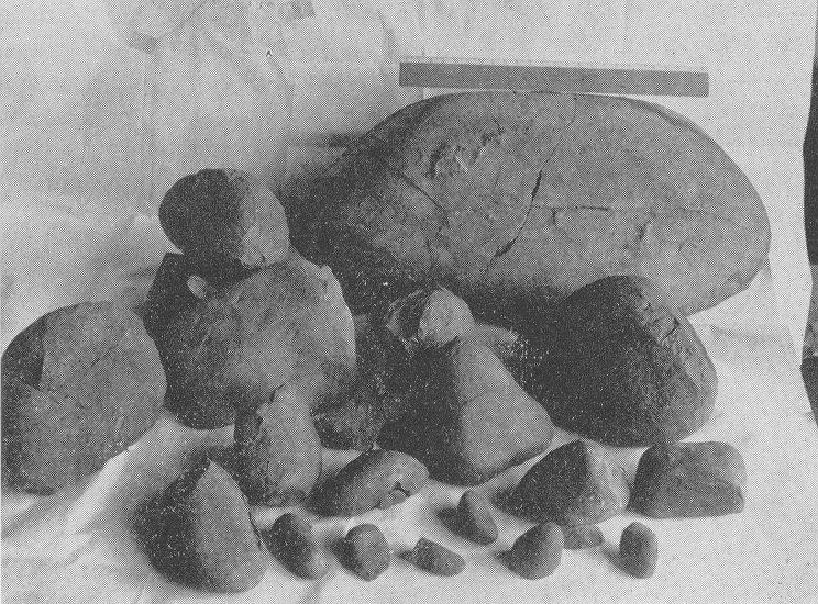
71

72
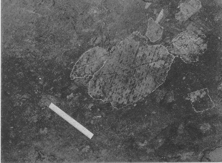
73
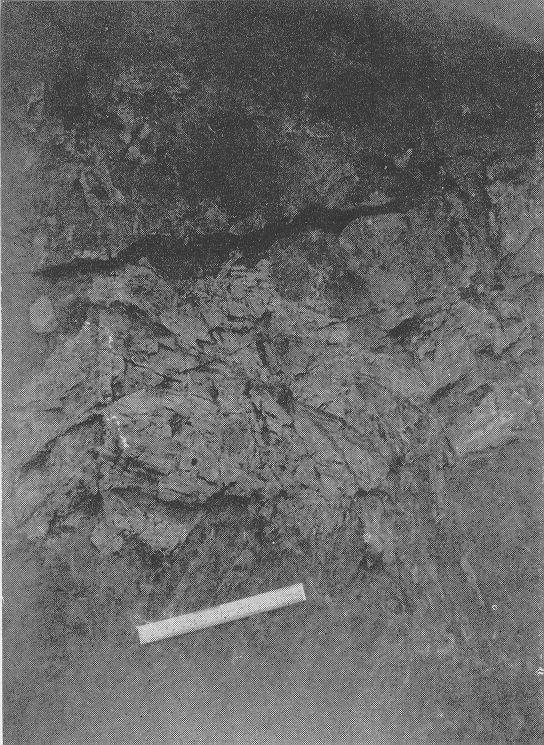
74
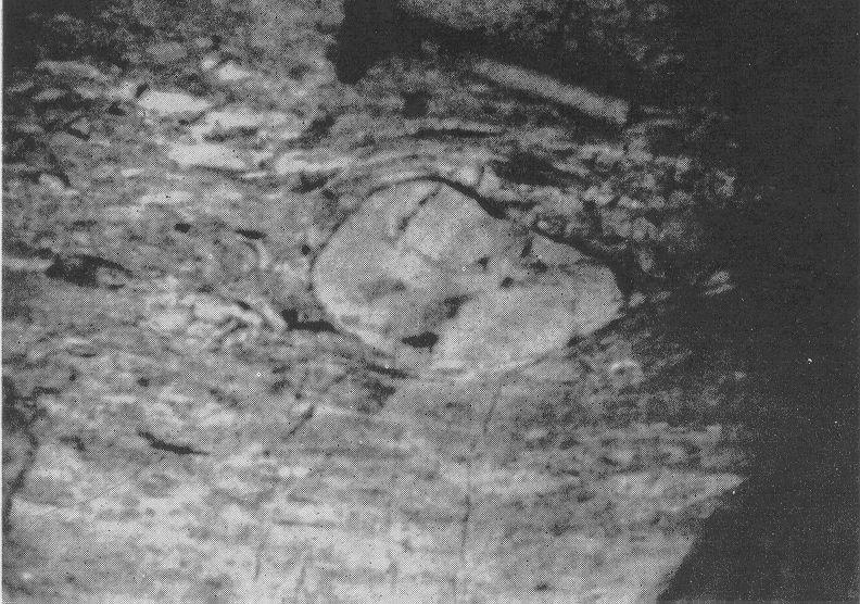
75
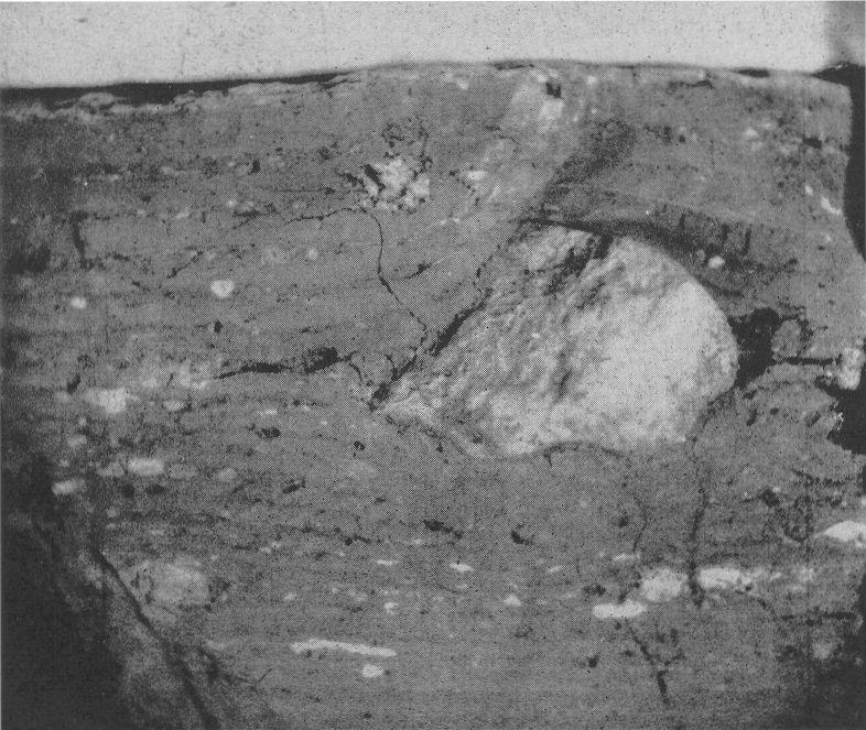
76
AGGREGATE RESOURCES OF ONTARIO (ARO) METADATA
 METADATA") AGGREGATE RESOURCES OF ONTARIO (ARO) METADATA GENERAL INFORMATION Official Name of the Data Set or Information Holding: Aggregate Resources of Ontario Acronyms are Used to Identify the Data Set or Information
AGGREGATE RESOURCES OF ONTARIO (ARO) METADATA GENERAL INFORMATION Official Name of the Data Set or Information Holding: Aggregate Resources of Ontario Acronyms are Used to Identify the Data Set or Information
GEOLOGY OF THE NICOLA GROUP BETWEEN MISSEZULA LAKE AND ALLISON LAKE
 GEOLOGY OF THE NICOLA GROUP BETWEEN MISSEZULA LAKE AND ALLISON LAKE (92H/15E. 10E1 By V. A. Preto INTRODUCTION Mapping was continued southward from the area covered in 1973 and an additional 55 square
MRD283-REV METADATA. Acronyms are Used to Identify the Data Set or Information Holding: MRD283-REV
 MRD283-REV METADATA GENERAL INFORMATION Official Name of the Data Set or Information Holding: Ambient Groundwater Geochemistry Data for Southern Ontario, 2007 2014 Acronyms are Used to Identify the Data
THESE TERMS GOVERN YOUR USE OF THIS DOCUMENT
 THESE TERMS GOVERN YOUR USE OF THIS DOCUMENT Your use of this Ontario Geological Survey document (the Content ) is governed by the terms set out on this page ( Terms of Use ). By downloading this Content,
Local: (705) Toll Free: , ext (inside Canada, United States) Local: (705) Toll Free: , ext.
 Toll Free: , ext (inside Canada, United States) Local: (705) Toll Free: , ext.") THESE TERMS GOVERN YOUR USE OF THIS DOCUMENT Your use of this Ontario Geological Survey document (the Content ) is governed by the terms set out on this page ( Terms of Use ). By downloading this Content,
THESE TERMS GOVERN YOUR USE OF THIS DOCUMENT Your use of this Ontario Geological Survey document (the Content ) is governed by the terms set out on this page ( Terms of Use ). By downloading this Content,
MRD 229-Revised METADATA
 GENERAL INFORMATION MRD 229-Revised METADATA Official Name of the Data Set or Information Holding: Till Compositional Database: Investigation of the Overburden Signature of the Caribou Lake Greenstone
GEOPHYSICAL DATA SET (GDS) 1084B METADATA
 1084B METADATA") GEOPHYSICAL DATA SET (GDS) 1084B METADATA GENERAL INFORMATION Official Name of the Data Set or Information Holding: Ontario Airborne Geophysical Surveys, Magnetic Gradiometer and Gamma-Ray Spectrometric
GEOPHYSICAL DATA SET (GDS) 1084B METADATA GENERAL INFORMATION Official Name of the Data Set or Information Holding: Ontario Airborne Geophysical Surveys, Magnetic Gradiometer and Gamma-Ray Spectrometric
MRD273-REV METADATA. Acronyms are Used to Identify the Data Set or Information Holding: MRD273-REV
 MRD273-REV METADATA GENERAL INFORMATION Official Name of the Data Set or Information Holding: Ontario Precambrian Bedrock Magnetic Susceptibility Geodatabase for 2001 to 2012 Acronyms are Used to Identify
MRD 281. Official Name of the Data Set or Information Holding: Northeastern Ontario Rhyolite Database
 MRD 281 GENERAL INFORMATION Official Name of the Data Set or Information Holding: Northeastern Ontario Rhyolite Database Acronyms are Used to Identify the Data Set or Information Holding: MRD281 Describe
MRD 228 METADATA. Official Name of the Data Set or Information Holding: Physiography of Southern Ontario
 MRD 228 METADATA GENERAL INFORMATION Official Name of the Data Set or Information Holding: Physiography of Southern Ontario Acronyms are Used to Identify the Data Set or Information Holding: MRD228 Describe
Local: (705) Toll Free: , ext (inside Canada, United States) Local: (705) Toll Free: , ext.
 Toll Free: , ext (inside Canada, United States) Local: (705) Toll Free: , ext.") THESE TERMS GOVERN YOUR USE OF THIS DOCUMENT Your use of this Ontario Geological Survey document (the Content ) is governed by the terms set out on this page ( Terms of Use ). By downloading this Content,
THESE TERMS GOVERN YOUR USE OF THIS DOCUMENT Your use of this Ontario Geological Survey document (the Content ) is governed by the terms set out on this page ( Terms of Use ). By downloading this Content,
THESE TERMS GOVERN YOUR USE OF THIS DOCUMENT
 THESE TERMS GOVERN YOUR USE OF THIS DOCUMENT Your use of this Ontario Geological Survey document (the Content ) is governed by the terms set out on this page ( Terms of Use ). By downloading this Content,
THESE TERMS GOVERN YOUR USE OF THIS DOCUMENT
 THESE TERMS GOVERN YOUR USE OF THIS DOCUMENT Your use of this Ontario Geological Survey document (the Content ) is governed by the terms set out on this page ( Terms of Use ). By downloading this Content,
=%REPORT RECONNAISSANCE OF CHISHOLM LAKE PROSPECT. October 25, 1977
 =%REPORT ON FIELD RECONNAISSANCE OF CHISHOLM LAKE PROSPECT October 25, 1977 Bruce D. Vincent Imperial Oil Limited, Minerals - Coal, CALGARY, ALBERTA CHISHOLM LAKE PROSPECT Introduction The Chisholm Lake
MRD 207 METADATA DETAIL PAGE
 MRD 207 METADATA DETAIL PAGE The following represents the Basic description of an information holding. To obtain more information about this holding, see the section named Contacts. GENERAL INFORMATION
A Geological Tour of Tumbledown Mountain, Maine
 Maine Geologic Facts and Localities April, 1998 A Geological Tour of Tumbledown Mountain, Maine 44 45 3.21 N, 70 32 50.24 W Text by Robert G. Marvinney, Department of Agriculture, Conservation & Forestry
Rock Identification. invisible rhyolite andesite basalt komatiite. visible granite diorite gabbro peridotite
 Rock Identification The samples in this lab are arranged into four groups: igneous, sedimentary, metamorphic, and unknown. Study the igneous, sedimentary, and metamorphic collections to get an idea of
B) color B) Sediment must be compacted and cemented before it can change to sedimentary rock. D) igneous, metamorphic, and sedimentary rocks
 color B) Sediment must be compacted and cemented before it can change to sedimentary rock. D) igneous, metamorphic, and sedimentary rocks") 1. Which characteristic of nonsedimentary rocks would provide the least evidence about the environment in which the rocks were formed? A) structure B) color C) crystal size D) mineral composition 2. Which
1. Which characteristic of nonsedimentary rocks would provide the least evidence about the environment in which the rocks were formed? A) structure B) color C) crystal size D) mineral composition 2. Which
As compaction and cementation of these sediments eventually occur, which area will become siltstone? A) A B) B C) C D) D
 A B) B C) C D) D") 1. A student obtains a cup of quartz sand from a beach. A saltwater solution is poured into the sand and allowed to evaporate. The mineral residue from the saltwater solution cements the sand grains together,
1. A student obtains a cup of quartz sand from a beach. A saltwater solution is poured into the sand and allowed to evaporate. The mineral residue from the saltwater solution cements the sand grains together,
Geologic Trips San Francisco and the Bay Area
 Excerpt from Geologic Trips San Francisco and the Bay Area by Ted Konigsmark ISBN 0-9661316-4-9 GeoPress All rights reserved. No part of this book may be reproduced without written permission in writing,
THE TOPOGRAPHY AND GEOLOGY OF THE GRAND PORTAGE^
 THE TOPOGRAPHY AND GEOLOGY OF THE GRAND PORTAGE^ Few areas within the boundaries of Minnesota are of greater historical interest than the region surrounding the Grand Portage, which long before the first
THESE TERMS GOVERN YOUR USE OF THIS DOCUMENT
 THESE TERMS GOVERN YOUR USE OF THIS DOCUMENT Your use of this Ontario Geological Survey document (the Content ) is governed by the terms set out on this page ( Terms of Use ). By downloading this Content,
The Geology of Sebago Lake State Park
 Maine Geologic Facts and Localities September, 2002 43 55 17.46 N, 70 34 13.07 W Text by Robert Johnston, Department of Agriculture, Conservation & Forestry 1 Map by Robert Johnston Introduction Sebago
LAB 2 IDENTIFYING MATERIALS FOR MAKING SOILS: ROCK AND PARENT MATERIALS
 LAB 2 IDENTIFYING MATERIALS FOR MAKING SOILS: ROCK AND PARENT MATERIALS Learning outcomes The student is able to: 1. understand and identify rocks 2. understand and identify parent materials 3. recognize
2 Aggregates in Indiana
 2 Aggregates in Indiana Origin of Aggregates Gravel and Natural Sands Crushed Stone Slag Distribution of Aggregates Glacial Deposits Bedrock Deposits Aggregate Types Natural Aggregates Artificial Aggregates
Practice Test Rocks and Minerals. Name. Page 1
 Name Practice Test Rocks and Minerals 1. Which rock would be the best source of the mineral garnet? A) basalt B) limestone C) schist D) slate 2. Which mineral is mined for its iron content? A) hematite
Section 5. Rock Units and Your Community. What Do You See? Think About It. Investigate. Learning Outcomes
 Chapter 3 Minerals, Rocks, and Structures Section 5 Rock Units and Your Community What Do You See? Learning Outcomes In this section, you will Recognize that rocks are arranged in Earth s crust as well-defined
Photo 119. Ripple marks in the Gordon Lake Formation. Highway 639 at the entrance to Laurentian Lodge.
 in particular of the Bruce Limestone by the Nipissing Diabase, has produced the rocks known as skarns (page 162). Regional metamorphism, particularly in the Massey - Whitefish Falls area, has produced
THESE TERMS GOVERN YOUR USE OF THIS DOCUMENT
 THESE TERMS GOVERN YOUR USE OF THIS DOCUMENT Your use of this Ontario Geological Survey document (the Content ) is governed by the terms set out on this page ( Terms of Use ). By downloading this Content,
NOA ASSESSMENT HARRIS QUARRY MENDOCINO COUNTY, CALIFORNIA TABLE OF CONTENTS
 NOA ASSESSMENT HARRIS QUARRY MENDOCINO COUNTY, CALIFORNIA TABLE OF CONTENTS Introduction... 1 Scope of Services... 1 Project Location and Description... 1 Geologic Setting... 1 Regional Geology... 1 Site
Geology 12 FINAL EXAM PREP. Possible Written Response Exam Questions
 Geology 12 FINAL EXAM PREP Possible Written Response Exam Questions Use this study guide to prepare for the written response portion of the final exam. Name FINAL EXAM - POSSIBLE WRITTEN RESPONSE QUESTIONS
The Geology of Two Lights State Park. Cape Elizabeth, Maine
 Maine Geologic Facts and Localities June, 2002 Cape Elizabeth, Maine 43 33 33.48 N, 70 12 13.32 W Text by Henry N. Berry IV and Robert G. Marvinney, Department of Agriculture, Conservation & Forestry 1
THESE TERMS GOVERN YOUR USE OF THIS DOCUMENT
 THESE TERMS GOVERN YOUR USE OF THIS DOCUMENT Your use of this Ontario Geological Survey document (the Content ) is governed by the terms set out on this page ( Terms of Use ). By downloading this Content,
Black Point & Bihler Point
 Black Point & Bihler Point Conglomerate Photo: looking north toward end of Black Point (south of post 1) All of the rocks in this photo are conglomerate. Both Black Point and Bihler Point are formed from
lin iibii i nm l i 31M05SE A.446 GILLIES 010
 ..-... lin iibii i nm l i 31M05SE0892 63A.446 GILLIES 010 t GEOLOGICAL REPORT ON HOUND CHUTE LAKE PROPERTY OF SILVER TOWER MINES LIMITED GILLIES LIMIT COBALT, ONTARIO (p Z A The property is located n Blocks
A. IGNEOUS Rocks formed by cooling and hardening of hot molten rock called magma (within crust or at its surface).
.") EARTH SCIENCE 11 CHAPTER 5 NOTES KEY How Earth's Rocks Were Formed Early geologists believed that the physical features of the Earth were formed by sudden spectacular events called CATASTROPHES. Modern
EARTH SCIENCE 11 CHAPTER 5 NOTES KEY How Earth's Rocks Were Formed Early geologists believed that the physical features of the Earth were formed by sudden spectacular events called CATASTROPHES. Modern
Bowen s Chemical Stability Series
 Lab 5 - Identification of Sedimentary Rocks Page - Introduction Sedimentary rocks are the second great rock group. Although they make up only a small percentage of the rocks in the earth s crust (~5%)
Sediment and sedimentary rocks Sediment
 Sediment and sedimentary rocks Sediment From sediments to sedimentary rocks (transportation, deposition, preservation and lithification) Types of sedimentary rocks (clastic, chemical and organic) Sedimentary
We are committed to providing accessible customer service. If you need accessible formats or communications supports, please contact us.
 We are committed to providing accessible customer service. If you need accessible formats or communications supports, please contact us. Nous tenons à améliorer l accessibilité des services à la clientèle.
I m good. Thank you.
 I m good. Thank you. The Rock Cycle Ag Earth Science Chapter 3.1 A natural occurring, inorganic crystalline material with a unique chemical composition. mineral A consolidated mixture of minerals rock
Directed Reading. Section: Rocks and the Rock Cycle. made of a. inorganic matter. b. solid organic matter. c. liquid organic matter. d. chemicals.
 Skills Worksheet Directed Reading Section: Rocks and the Rock Cycle 1. The solid part of Earth is made up of material called a. glacial ice. b. lava. c. rock. d. wood. 2. Rock can be a collection of one
Maine Geologic Facts and Localities October, Lobster Lake, Maine. Text by Robert G. Marvinney. Maine Geological Survey
 Maine Geologic Facts and Localities October, 1998 Lobster Lake, Maine 45 o 51 7.91 N, 69 o 30 53.88 W Text by Robert G. Marvinney, Department of Agriculture, Conservation & Forestry 1 Map by Introduction
PROSPECTING REPORT. Broken Hill Property. EVENT # TENURE # Tenure Name: Broken Hill. New Westminster Mining Division Map 092H
 2009-2010 PROSPECTING REPORT Broken Hill Property EVENT # 4514071 TENURE # 600988 Tenure Name: Broken Hill New Westminster Mining Division Map 092H Central Coordinate Reference 121 24 26.2 W Longitude
LAB 6: TRINIDAD BEACH FIELD TRIP
 OBJECTIVES: LAB 6: TRINIDAD BEACH FIELD TRIP 1) to develop your powers of observation, especially of geological phenomena; 2) to identify the rocks exposed at Trinidad Beach; 3) to reconstruct some of
THESE TERMS GOVERN YOUR USE OF THIS DOCUMENT
 THESE TERMS GOVERN YOUR USE OF THIS DOCUMENT Your use of this Ontario Geological Survey document (the Content ) is governed by the terms set out on this page ( Terms of Use ). By downloading this Content,
Introducti on. Land Survey. Geomagnetic Survey. Geomagnetic Results and Interpretati ons - Conclusions and Recommendations C
 m M 42A86SW8281 63.42 PRICE 010 C O H T E H l 42A86SW828I 63.42 PRICE 010C Introducti on Land Survey Geomagnetic Survey Geomagnetic Results and Interpretati ons - Conclusions and Recommendations - - -
INTRODUCTION REGIONAL GEOLOGY. N. St-Jean 1, L. Hunt 1 and R.L. Sherlock 1
 37. Preliminary Results from Mapping a New Exposure of the Basal Unconformity Between the Hearst and Larder Lake Assemblages, Skead Township, Northeastern Ontario N. St-Jean 1, L. Hunt 1 and R.L. Sherlock
Chapter 4 Rocks & Igneous Rocks
 Chapter 4 Rocks & Igneous Rocks Rock Definition A naturally occurring consolidated mixture of one or more minerals e.g, marble, granite, sandstone, limestone Rock Definition Must naturally occur in nature,
GLY 155 Introduction to Physical Geology, W. Altermann. Press & Siever, compressive forces. Compressive forces cause folding and faulting.
 Press & Siever, 1995 compressive forces Compressive forces cause folding and faulting. faults 1 Uplift is followed by erosion, which creates new horizontal surface. lava flows Volcanic eruptions cover
Principles of Geology
 Principles of Geology Essential Questions What is Uniformitarianism? What is Catastrophism? What is Steno s s Law? What are the other geologic principles? How is relative age determined using these principles?
Nickel Division - Sudbury Operations
 * *-.. FALCONBRIDGE NICKEL MINES LIMITED Nickel Division - Sudbury Operations Falconbridge, Ontario 002261 GRAHAM 010 GEOLOGY OF TllE NORTH QUARTER OP LOT 2, CON. IV, GRAHAM TOWNSHIP, DISTRICT OP SUDBURY,
RR#7 - Multiple Choice
 1. Which mineral is mined for its iron content? 1) hematite 2) fluorite 3) galena 4) talc 2. Which rock is composed of the mineral halite that formed when seawater evaporated? 1) limestone 2) dolostone
Chapter 10. Chapter Rocks and the Rock Cycle. Rocks. Section 1 Rocks and the Rock Cycle
 Chapter 10 Rocks 1 Chapter 10 Section 1 Rocks and the Rock Cycle 2 10.1 Rocks and the Rock Cycle Magma is the parent material for all rocks. Once the magma cools and hardens, many changes can occur. Geology:
Engineering Geology. Igneous rocks. Hussien Al - deeky
 Igneous rocks Hussien Al - deeky 1 The Geology Definition of Rocks In Geology Rock is defined as the solid material forming the outer rocky shell or crust of the earth. There are three major groups of
Version 1 Page 1 Barnard/George/Ward
 The Great Mineral & Rock Test 1. Base your answer to the following question on the table below which provides information about the crystal sizes and the mineral compositions of four igneous rocks, A,
THE ROCK CYCLE & ROCKS. Subtitle
 THE ROCK CYCLE & ROCKS Subtitle 3. Three rocks that do not have minerals or are composed of nonmineral matter. Coal Pumuce Obsidian THE ROCK CYCLE Why do scientists study rocks? Rocks contain clues about
Igneous Rocks: Formed by Fire (p )
") READING QUESTIONS: Chapter 2 (Rocks) PSCI 131 18/WI 70 pts NAME DUE: Monday, January 29 Igneous Rocks: Formed by Fire (p. 34-43) 1. What is magma? 2. Extrusive igneous rocks form at the Earth s, and intrusive
READING QUESTIONS: Chapter 2 (Rocks) PSCI 131 18/WI 70 pts NAME DUE: Monday, January 29 Igneous Rocks: Formed by Fire (p. 34-43) 1. What is magma? 2. Extrusive igneous rocks form at the Earth s, and intrusive
Which rock is shown? A) slate B) dunite C) gneiss D) quartzite
 slate B) dunite C) gneiss D) quartzite") 1. Which metamorphic rock will have visible mica crystals and a foliated texture? A) marble B) quartzite C) schist D) slate 2. The recrystallization of unmelted material under high temperature and pressure
1. Which metamorphic rock will have visible mica crystals and a foliated texture? A) marble B) quartzite C) schist D) slate 2. The recrystallization of unmelted material under high temperature and pressure
THE OHIO JOURNAL OF SCIENCE
 THE OHIO JOURNAL OF SCIENCE VOL. LI JANUARY 1951 No. 1 SHORE EROSION ON SANDUSKY BAY PAUL R. SHAFFER Department of Geology, University of Illinois, Urbana, 111. The south shore of San dusky Bay is undergoing
Local: (705) Toll Free: , ext (inside Canada, United States) Local: (705) Toll Free: , ext.
 Toll Free: , ext (inside Canada, United States) Local: (705) Toll Free: , ext.") THESE TERMS GOVERN YOUR USE OF THIS DOCUMENT Your use of this Ontario Geological Survey document (the Content ) is governed by the terms set out on this page ( Terms of Use ). By downloading this Content,
THESE TERMS GOVERN YOUR USE OF THIS DOCUMENT Your use of this Ontario Geological Survey document (the Content ) is governed by the terms set out on this page ( Terms of Use ). By downloading this Content,
GIFFORD PINCHOT STATE PARK DIABASE (MOLTEN LIQUID ROCK)
") PENNSYLVANIA TRAIL OF GEOLOGY PARK GUIDE 10 GIFFORD PINCHOT STATE PARK DIABASE (MOLTEN LIQUID ROCK) Gifford Pinchot State Park contains examples of the three major rock classes: igneous, metamorphic, and
PENNSYLVANIA TRAIL OF GEOLOGY PARK GUIDE 10 GIFFORD PINCHOT STATE PARK DIABASE (MOLTEN LIQUID ROCK) Gifford Pinchot State Park contains examples of the three major rock classes: igneous, metamorphic, and
Igneous, Metamorphic & Sedimentary. Chapter 5 & Chapter 6
 Igneous, Metamorphic & Sedimentary Chapter 5 & Chapter 6 Section 5.1 What are Igneous Rocks? Compare and contrast intrusive and extrusive igneous rocks. Describe the composition of magma Discuss the factors
Earth Science Chapter 6 Rocks
 Earth Science Chapter 6 Rocks I. Rocks and the Rock Cycle * Material that makes up the solid part of the Earth. * Made of a variety of different combinations of minerals and organic matter. A. Three Major
THESE TERMS GOVERN YOUR USE OF THIS DOCUMENT
 THESE TERMS GOVERN YOUR USE OF THIS DOCUMENT Your use of this Ontario Geological Survey document (the Content ) is governed by the terms set out on this page ( Terms of Use ). By downloading this Content,
Answers: Internal Processes and Structures (Isostasy)
") Answers: Internal Processes and Structures (Isostasy) 1. Analyse the adjustment of the crust to changes in loads associated with volcanism, mountain building, erosion, and glaciation by using the concept
Answers: Internal Processes and Structures (Isostasy) 1. Analyse the adjustment of the crust to changes in loads associated with volcanism, mountain building, erosion, and glaciation by using the concept
What Do You See? Learning Outcomes Goals Learning Outcomes Think About It Identify classify In what kinds of environments do igneous rocks form?
 Section 2 Igneous Rocks and the Geologic History of Your Community What Do You See? Learning Outcomes In this section, you will Goals Text Learning Outcomes In this section, you will Identify and classify
THESE TERMS GOVERN YOUR USE OF THIS DOCUMENT
 THESE TERMS GOVERN YOUR USE OF THIS DOCUMENT Your use of this Ontario Geological Survey document (the Content ) is governed by the terms set out on this page ( Terms of Use ). By downloading this Content,
General Geology Lab #7: Geologic Time & Relative Dating
 General Geology 89.101 Name: General Geology Lab #7: Geologic Time & Relative Dating Purpose: To use relative dating techniques to interpret geological cross sections. Procedure: Today we will be interpreting
Lecture 3 Rocks and the Rock Cycle Dr. Shwan Omar
 Rocks A naturally occurring aggregate of one or more minerals (e.g., granite), or a body of non-crystalline material (e.g., obsidian glass), or of solid organic material (e.g., coal). Rock Cycle A sequence
Rocks. Rocks are composed of 1 or more minerals. Rocks are classified based on how they formed (origin). 3 classes of rocks:
. 3 classes of rocks:") ROCKS Rocks If a mineral is a naturally occurring homogeneous solid, inorganically formed, with a definite chemical composi:on and a crystalline structure then what is a rock? Rocks Rocks are composed
ROCKS Rocks If a mineral is a naturally occurring homogeneous solid, inorganically formed, with a definite chemical composi:on and a crystalline structure then what is a rock? Rocks Rocks are composed
RE~ORT ON. J.F.V. MILLAR, P. Eng. GEOCHEMICAL SURVEY TIMBASKET AND MOGUL MINERAL CLAIMS. Kinbasket Lake, B. C. 51 degrees 118 degrees N.E.
 RE~ORT ON GEOCHEMICAL SURVEY TIMBASKET AND MOGUL MINERAL CLAIMS Kinbasket Lake, B. C. 51 degrees 118 degrees N.E. J.F.V. MILLAR, P. Eng. Lease held by J.F.V. MILLAR Work done Sept. 22 - Oct. 3, 1967. REPORT
Introduction to Prospecting. Session Two Geology
 Introduction to Prospecting Session Two Geology The Earth Earth is 4.6 billion years old (Ba). Bacteria & algae +3.5 Ba. Microscopic animals ~2 Ba. Animals ~600 million years (Ma) old. Mankind about 100,000
THE STRUCTURE AND THICKNESS OF THE CLINTON AND BEREA FORMATIONS IN THE VICINITY OF WOOSTER, OHIO
 THE STRUCTURE AND THICKNESS OF THE CLINTON AND BEREA FORMATIONS IN THE VICINITY OF WOOSTER, OHIO KARL VER STEEG College of Wooster INTRODUCTION AND ACKNOWLEDGMENTS The data used in the construction of
Lab 7: Sedimentary Structures
 Name: Lab 7: Sedimentary Structures Sedimentary rocks account for a negligibly small fraction of Earth s mass, yet they are commonly encountered because the processes that form them are ubiquitous in the
FIREPLACE GEOLOGY. Dining Hall
 FIREPLACE GEOLOGY Dining Hall The Dining Hall fireplace represents a slice through a Cascade Mountain volcano. Volcanoes are formed from molten magma rising up from within the Earth s crust. Magma that
Essentials of Geology, 11e
 Essentials of Geology, 11e Igneous Rocks and Intrusive Activity Chapter 3 Instructor Jennifer Barson Spokane Falls Community College Geology 101 Stanley Hatfield Southwestern Illinois College Characteristics
COMPOSITIONAL TERMS: FELSIC : light colored INTERMEDIATE : medium shades MAFIC : dark colored ULTRAMAFIC : rare (composition of the mantle)
") GEOLOGY 306 Laboratory NAME: Instructor: TERRY J. BOROUGHS SECTION: Common Rocks (Chapter 2) For this assignment, you will require: a streak plate, glass plate, magnet, dilute hydrochloric (HCl) acid,
GEOLOGY 306 Laboratory NAME: Instructor: TERRY J. BOROUGHS SECTION: Common Rocks (Chapter 2) For this assignment, you will require: a streak plate, glass plate, magnet, dilute hydrochloric (HCl) acid,
Rocks and the Rock Cycle notes from the textbook, integrated with original contributions
 Rocks and the Rock Cycle notes from the textbook, integrated with original contributions Alessandro Grippo, Ph.D. Gneiss (a metamorphic rock) from Catalina Island, California Alessandro Grippo review Rocks
Objectives: Define Relative Age, Absolute Age
 S6E5. Students will investigate the scientific view of how the earth s surface is formed. c. Classify rocks by their process of formation. g. Describe how fossils show evidence of the changing surface
Local: (705) Toll Free: , ext (inside Canada, United States) Local: (705) Toll Free: , ext.
 Toll Free: , ext (inside Canada, United States) Local: (705) Toll Free: , ext.") THESE TERMS GOVERN YOUR USE OF THIS DOCUMENT Your use of this Ontario Geological Survey document (the Content ) is governed by the terms set out on this page ( Terms of Use ). By downloading this Content,
THESE TERMS GOVERN YOUR USE OF THIS DOCUMENT Your use of this Ontario Geological Survey document (the Content ) is governed by the terms set out on this page ( Terms of Use ). By downloading this Content,
EPS 50 Lab 2: Igneous Rocks Grotzinger and Jordan, Chapter 4
 Name: EPS 50 Lab 2: Igneous Rocks Grotzinger and Jordan, Chapter 4 Introduction In the previous lab, we learned about mineral characteristics, properties and identities as well as the three basic rock
GY 112L Earth History
 GY 112L Earth History Lab 2 Vertical Successions and Sequences of Events GY 112L Instructors: Douglas Haywick, James Connors, Mary Anne Connors Department of Earth Sciences, University of South Alabama
3. GEOLOGY. 3.1 Introduction. 3.2 Results and Discussion Regional Geology Surficial Geology Mine Study Area
 3. GEOLOGY 3.1 Introduction This chapter discusses the baseline study of the geology and mineralization characteristics of the mine study area. The study consolidates existing geological data and exploration
THE DISSECTED VOLCANO OF CRANDALL BASIN, WYOMING.*
 THE DISSECTED VOLCANO OF CRANDALL BASIN, WYOMING.* THE writer in exploring the north-eastern corner of the Yellowstone National Park and the country east of it came upon evidences of a great volcano, which
Pacific Northwest Rock Lab, Part II. Igneous Rocks. Name Per.
 Name Per. Pacific Northwest Rock Lab, Part II After you ve classified all your rocks, place their numbers next to the names and read the information about the rock. Check the classifications here (igneous,
1. Base your answer to the following question on on the photographs and news article below. Old Man s Loss Felt in New Hampshire
 UNIT 3 EXAM ROCKS AND MINERALS NAME: BLOCK: DATE: 1. Base your answer to the following question on on the photographs and news article below. Old Man s Loss Felt in New Hampshire FRANCONIA, N.H. Crowds
EPS 50 Lab 4: Sedimentary Rocks
 Name: EPS 50 Lab 4: Sedimentary Rocks Grotzinger and Jordan, Chapter 5 Introduction In this lab we will classify sedimentary rocks and investigate the relationship between environmental conditions and
Uncovering The Riches of the Abitibi Greenstone Belt of Canada
 1 TSX.V: ALZ June 2016 Uncovering The Riches of the Abitibi Greenstone Belt of Canada The Haultain Gold Discovery The Abitibi Greenstone Belt & Gold 170+ million oz of gold produced to date from more than
Rocks & Minerals. Lesson 1 Properties of Minerals. What is a mineral? What is a mineral?
 Rocks & Minerals What is a mineral? A mineral must have 5 specific characteristics to be considered a mineral a. b. c. d. e. Naturally occurring - formed by natural processes. Solid - must have a definite
THESE TERMS GOVERN YOUR USE OF THIS DOCUMENT
 THESE TERMS GOVERN YOUR USE OF THIS DOCUMENT Your use of this Ontario Geological Survey document (the Content ) is governed by the terms set out on this page ( Terms of Use ). By downloading this Content,
Answers. Rocks. Year 8 Science Chapter 8
 Answers Rocks Year 8 Science Chapter 8 p171 1 Rocks are made up of minerals such as quartz, feldspars, micas, and calcite. Different rocks are made up of different combinations of minerals. 2 Igneous,
Marshall Shore Town Park, Liberty, Maine
 Maine Geologic Facts and Localities August, 2005 Marshall Shore Town Park, Liberty, Maine 44 22 33.04 N, 69 21 9.19 W Text by Henry N. Berry IV, Department of Agriculture, Conservation & Forestry 1 Introduction
Petrology and Alteration of Lari Mountain in Arinem Area, West Java, Indonesia
 Petrology and Alteration of Lari Mountain in Arinem Area, West Java, Indonesia Fatoni Adyahya 1 *, Euis T. Yuningsih 1, Ildrem Syafrie 1, H. Matsueda 2, A. Hardiyono 1 1 Faculty of Geology, University
Angel International School - Manipay
 c Grade 8 Angel International School - Manipay 1 st Term Examination November, 2016 Chemistry PART I Multiple Choice Questions. Duration: 02 Hours Index No:- (1) A common sedimentary rock which is formed
Prospecting Report 'S Office i DB Property, B.C. -J Negro Creek Nelson Mining District NTS 82F.050. Operator: Kootenay Gold Inc.
 . '.' I"' i9 12 Prospecting Report 'S Office i DB Property, B.C. -J Negro Creek Nelson Mining District NTS 82F.050 Operator: Kootenay Gold Inc. Owner: Darlene Lavoie Work Performed Summer of 2007 Report
THE OCCURRENCE OF COAL AND MICA IN PLEISTOCENE DEPOSITS NEAR CINCINNATI.
 THE OCCURRENCE OF COAL AND MICA IN PLEISTOCENE DEPOSITS NEAR CINCINNATI. L. S. BRAND, University of Cincinnati. INTRODUCTION. The occurrence of coal and mica in Pleistocene deposits has not been reported
The Geology of Cobscook Bay State Park
 Maine Geologic Facts and Localities August, 2000 44 50 24.67 N, 67 9 3.01 W Text by Robert A. Johnston, Department of Agriculture, Conservation & Forestry 1 Map by USGS Introduction Cobscook Bay State