Local: (705) Toll Free: , ext (inside Canada, United States) Local: (705) Toll Free: , ext.
|
|
|
- Madlyn Jefferson
- 6 years ago
- Views:
Transcription
1 THESE TERMS GOVERN YOUR USE OF THIS DOCUMENT Your use of this Ontario Geological Survey document (the Content ) is governed by the terms set out on this page ( Terms of Use ). By downloading this Content, you (the User ) have accepted, and have agreed to be bound by, the Terms of Use. Content: This Content is offered by the Province of Ontario s Ministry of Northern Development and Mines (MNDM) as a public service, on an as-is basis. Recommendations and statements of opinion expressed in the Content are those of the author or authors and are not to be construed as statement of government policy. You are solely responsible for your use of the Content. You should not rely on the Content for legal advice nor as authoritative in your particular circumstances. Users should verify the accuracy and applicability of any Content before acting on it. MNDM does not guarantee, or make any warranty express or implied, that the Content is current, accurate, complete or reliable. MNDM is not responsible for any damage however caused, which results, directly or indirectly, from your use of the Content. MNDM assumes no legal liability or responsibility for the Content whatsoever. Links to Other Web Sites: This Content may contain links, to Web sites that are not operated by MNDM. Linked Web sites may not be available in French. MNDM neither endorses nor assumes any responsibility for the safety, accuracy or availability of linked Web sites or the information contained on them. The linked Web sites, their operation and content are the responsibility of the person or entity for which they were created or maintained (the Owner ). Both your use of a linked Web site, and your right to use or reproduce information or materials from a linked Web site, are subject to the terms of use governing that particular Web site. Any comments or inquiries regarding a linked Web site must be directed to its Owner. Copyright: Canadian and international intellectual property laws protect the Content. Unless otherwise indicated, copyright is held by the Queen s Printer for Ontario. It is recommended that reference to the Content be made in the following form: <Author s last name>, <Initials> <year of publication>. <Content title>; Ontario Geological Survey, <Content publication series and number>, <total number of pages>p. Use and Reproduction of Content: The Content may be used and reproduced only in accordance with applicable intellectual property laws. Non-commercial use of unsubstantial excerpts of the Content is permitted provided that appropriate credit is given and Crown copyright is acknowledged. Any substantial reproduction of the Content or any commercial use of all or part of the Content is prohibited without the prior written permission of MNDM. Substantial reproduction includes the reproduction of any illustration or figure, such as, but not limited to graphs, charts and maps. Commercial use includes commercial distribution of the Content, the reproduction of multiple copies of the Content for any purpose whether or not commercial, use of the Content in commercial publications, and the creation of value-added products using the Content. Contact: FOR FURTHER INFORMATION ON The Reproduction of Content The Purchase of MNDM Publications PLEASE CONTACT: BY TELEPHONE: BY MNDM Publication Services MNDM Publication Sales Local: (705) Toll Free: , ext (inside Canada, United States) Local: (705) Toll Free: , ext (inside Canada, United States) Crown Copyright Queen s Printer Local: (416) Toll Free: (inside Canada, United States) Pubsales@ndm.gov.on.ca Pubsales@ndm.gov.on.ca Copyright@gov.on.ca
2 LES CONDITIONS CI-DESSOUS RÉGISSENT L'UTILISATION DU PRÉSENT DOCUMENT. Votre utilisation de ce document de la Commission géologique de l'ontario (le «contenu») est régie par les conditions décrites sur cette page («conditions d'utilisation»). En téléchargeant ce contenu, vous (l'«utilisateur») signifiez que vous avez accepté d'être lié par les présentes conditions d'utilisation. Contenu : Ce contenu est offert en l'état comme service public par le ministère du Développement du Nord et des Mines (MDNM) de la province de l'ontario. Les recommandations et les opinions exprimées dans le contenu sont celles de l'auteur ou des auteurs et ne doivent pas être interprétées comme des énoncés officiels de politique gouvernementale. Vous êtes entièrement responsable de l'utilisation que vous en faites. Le contenu ne constitue pas une source fiable de conseils juridiques et ne peut en aucun cas faire autorité dans votre situation particulière. Les utilisateurs sont tenus de vérifier l'exactitude et l'applicabilité de tout contenu avant de l'utiliser. Le MDNM n'offre aucune garantie expresse ou implicite relativement à la mise à jour, à l'exactitude, à l'intégralité ou à la fiabilité du contenu. Le MDNM ne peut être tenu responsable de tout dommage, quelle qu'en soit la cause, résultant directement ou indirectement de l'utilisation du contenu. Le MDNM n'assume aucune responsabilité légale de quelque nature que ce soit en ce qui a trait au contenu. Liens vers d'autres sites Web : Ce contenu peut comporter des liens vers des sites Web qui ne sont pas exploités par le MDNM. Certains de ces sites pourraient ne pas être offerts en français. Le MDNM se dégage de toute responsabilité quant à la sûreté, à l'exactitude ou à la disponibilité des sites Web ainsi reliés ou à l'information qu'ils contiennent. La responsabilité des sites Web ainsi reliés, de leur exploitation et de leur contenu incombe à la personne ou à l'entité pour lesquelles ils ont été créés ou sont entretenus (le «propriétaire»). Votre utilisation de ces sites Web ainsi que votre droit d'utiliser ou de reproduire leur contenu sont assujettis aux conditions d'utilisation propres à chacun de ces sites. Tout commentaire ou toute question concernant l'un de ces sites doivent être adressés au propriétaire du site. Droits d'auteur : Le contenu est protégé par les lois canadiennes et internationales sur la propriété intellectuelle. Sauf indication contraire, les droits d'auteurs appartiennent à l'imprimeur de la Reine pour l'ontario. Nous recommandons de faire paraître ainsi toute référence au contenu : nom de famille de l'auteur, initiales, année de publication, titre du document, Commission géologique de l'ontario, série et numéro de publication, nombre de pages. Utilisation et reproduction du contenu : Le contenu ne peut être utilisé et reproduit qu'en conformité avec les lois sur la propriété intellectuelle applicables. L'utilisation de courts extraits du contenu à des fins non commerciales est autorisé, à condition de faire une mention de source appropriée reconnaissant les droits d'auteurs de la Couronne. Toute reproduction importante du contenu ou toute utilisation, en tout ou en partie, du contenu à des fins commerciales est interdite sans l'autorisation écrite préalable du MDNM. Une reproduction jugée importante comprend la reproduction de toute illustration ou figure comme les graphiques, les diagrammes, les cartes, etc. L'utilisation commerciale comprend la distribution du contenu à des fins commerciales, la reproduction de copies multiples du contenu à des fins commerciales ou non, l'utilisation du contenu dans des publications commerciales et la création de produits à valeur ajoutée à l'aide du contenu. Renseignements : POUR PLUS DE RENSEIGNEMENTS SUR la reproduction du contenu l'achat des publications du MDNM les droits d'auteurs de la Couronne VEUILLEZ VOUS ADRESSER À : Services de publication du MDNM Vente de publications du MDNM Imprimeur de la Reine PAR TÉLÉPHONE : PAR COURRIEL : Local : (705) Numéro sans frais : , poste 5691 (au Canada et aux États-Unis) Local : (705) Numéro sans frais : , poste 5691 (au Canada et aux États-Unis) Local : Numéro sans frais : (au Canada et aux États-Unis) Pubsales@ndm.gov.on.ca Pubsales@ndm.gov.on.ca Copyright@gov.on.ca
3 PROVINCE OF ONTARIO DEPARTMENT OF MINES HON. CHARLES MCCREA, Minister of Mines THOS. W. GIBSON, Deputy Minister Bulletin No. 48 The South Lorrain Silver Area By CYRIL W. KNIGHT To accompany Report by Cyril W. Knight on Underground Workings in Cobalt and South Lorrain in the Thirty-first Report of the Ontario Department of Mines, Part II. PRINTED BY ORDER OF THE LEGISLATIVE ASSEMBLY OF ONTARIO TORONTO: Printed and Published by Clarkson W. James, Printer to the King's Most Excellent Majesty 1923
4
5 PREFACE This report 6n South Lorrain is an advance part of a larger report on the Cobalt and South Lorrain silver areas shortly to be published by the Ontario Department of Mines in Volume Thirty-one, Part Two. The full report deals more particularly with the geology of the mine workings, and will constitute a supplementary report to Dr. Willet G. Miller's well-known memoir on Cobalt, published in 1913 in Volume Nineteen, Part Two, of the Ontario Bureau of Mines. Toronto, August, C.W.K.
6 CONTENTS PAGE Introduction Production Vein minerals Where veins occur Pre-glacial weathering Length of ore-shoots The "Mother lode" Faults Discovery of ore-bodies Maps and plans General geology The South Lorrain diabase dome Details of the South Lorrain diabase dome The outside of the diabase dome The inside of the diabase dome Description of properties Keeley Veins and rock structures Pre-glacial weathering Secondary silver Description of Keeley mine work ings Workings from No. 3 shaft Workings from No. 4 shaft (Beaver lake) Workings from No. l shaft, original discovery, Keeley mine Frontier and Crompton Pre-glacial weathering PAGE Early history of Frontier mine Description of Frontier mine work ings Wettlaufer Curry claim, H.R Silver Eagle claim, H.R Bellellen claim, R.L Maidens claims, H.R. 69, H.R. 70, H.R. 67, H.R Little Keeley claim, H.S Lorrain Consolidated, H.R Montrose, H.R T.C Taylor claim, R.L Alice Lorrain claim, R.L Forneri claim, H.S Sharp Lake claim, B.C H.R H.R Tallen claim, H.R King George claims, H.R. 110, H.R T.C Toronto Lorrain claim, H.S H.S H.R Lang-Caswell Giroux Trout Lake Mining Company claim, H.R
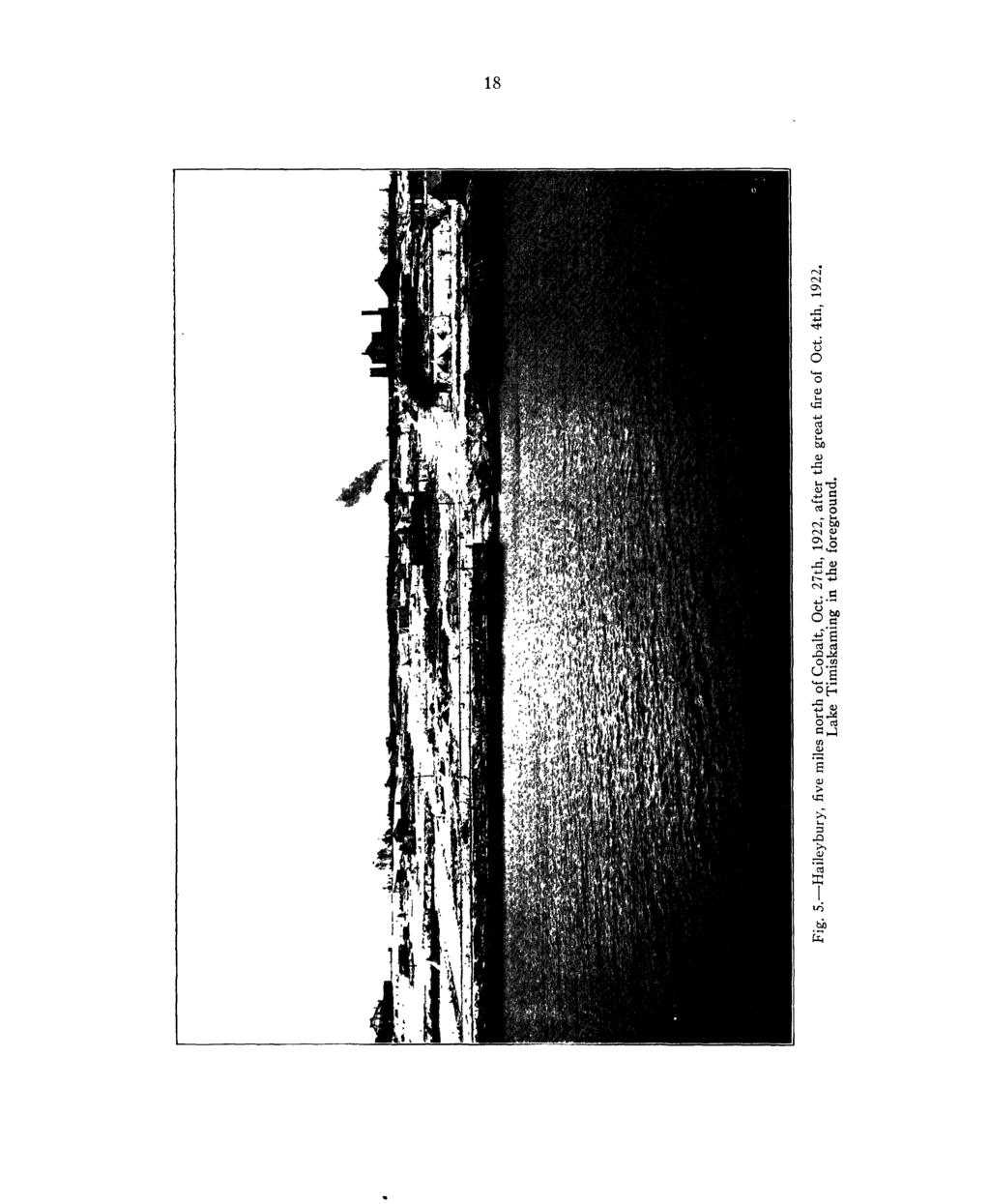
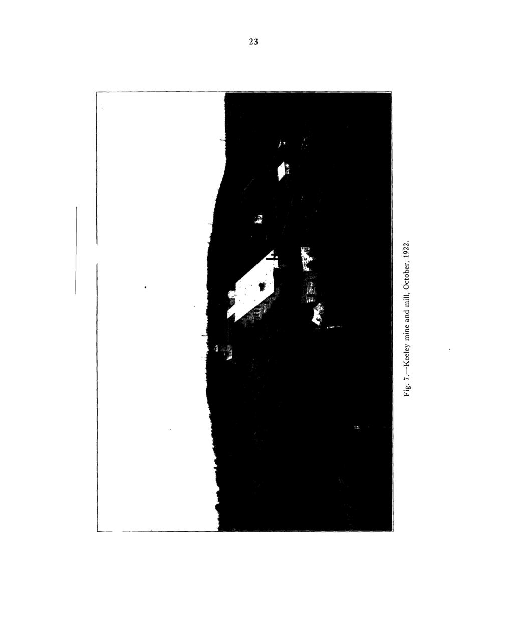
7 ILLUSTRATIONS PAGE Fig. I. Wood's vein, north face, Keeley mine, 480-ft. level, October 12th, The vein averages 10 inches in width and assays 8,000 to 14,800 ounces of silver per ton. This ore is in the Nipissing diabase sill, about 50 or 60 feet below the top of the sill. Major Leonard G. Smith in the photograph Fig. 3. Mr. J. M. Wood, pioneer in South Lorrain. He and his partner, Mr. R. J. Jowsey, were joint discoverers of the Keeley mine. The "WTood's" vein was named after Mr. Wood. The Keeley mine was named after Mr. Chas. Keeley, \vho was associated with Jowsey and Wood Fig. 4. Mr. R. J. Jowsey, pioneer in South Lorrain. He and his partner, Mr. J. M. Wood, were joint discoverers of the Keeley mine Fig. 5. Haileybury, five miles north of Cobalt, October 27th, 1922, after the great fire of October 4th, Lake Timiskaming in foreground Fig. 7. Keeley mine and mill, October, Fig. 8. Keeley mine, vein No. 26, 480-ft. level, January 24th, The vein is four to five feet wide on this face, but pinches out rapidly to normal size. The ore averages 7,000 ounces of silver per ton. Major Leonard G. Smith in the photograph Fig. 9. Frontier mine on left, Keeley mine on right Fig. 10. Wood's vein, Crompton mine, 300-ft. level, back of stope, showing a width of 30 inches of high-grade silver ore. Photograph furnished by the Mining Corporation of Canada, Limited Fig. 14. Old Keeley workings, No. l shaft; the original discovery was made in this place.. 55 MAPS AND PLANS Plan showing relative position of South Lorrain Geological map of South Lorrain, scale one mile to the inch., Plan showing claims in South Lorrain Plan showing mine workings of Wettlaufer Plan showing mine workings of Maidens claim, H.R SECTIONS Ssction 'along line A-B, showing dome structure of Nipissing diabase sill Vertical section along vein 16 and through No. 3 shaft, Keeley mine Stope section on Wood's vein, Keeley mine Vertical section through No. l shaft, Frontier mine Stope section of Wettlaufer vein

8 Fig. 1. Wood's vein, north face, Keeley mine, 480-ft. level, October 12th, The vein averages 10 inches in width and assays 8,000 to 14,800 ounces of silver per ton. This ore is in the Nipissing diabase sill, about 50 or 60 feet below the top of the sill. Major Leonard (i. Smith in the photograph.
9 SOUTH LORRAIN By CYRIL W. KNIGHT Introduction. The productive part of the South Lorrain silver field occupies a compara tively small area, probably less than one hundred acres. It is sixteen miles southeast of the town of Cobalt. The field may be reached by a road from Cobalt, or by a pleasant twenty-mile trip on a steamboat from the town of Haileybury down Lake Timiskaming. From the wharf at South Lorrain it is about three miles westward over a rough road to the Keeley, Frontier and Wettlaufer mines. South Lorrain at the present time is attracting much attention owing to rich silver ore-shoots which have been discovered at the Keeley and Frontier T I M I S K A NIPISSIN G/SOUTH Fig. 2. Plan showing relative position of South Lorrain. mines during the last two years. As a result it is certain that much new explora tion will be carried on, with the object of ascertaining whether the present small productive area can be enlarged. The field was examined in the fall of 1921 and 1922, and brief visits were also made in January and May, In the year 1922 there were only two operating companies, namely, The Mining Corporation of Canada, Limited, working the Frontier, and the Keeley Silver Mines, Limited, operating the Keeley. 7
10 The history of *South Lorrain has had its tragic and romantic aspects, its ups and downs. Silver was discovered in 1907 at the Keeley mine, and there followed a period of widespread staking of claims, and of active work lasting until the latter part of the year During this time, which may be called the first period in the history of the camp, there were produced about 2,446,235 ounces of silver, practically all of which came from the Wettlaufer mine. The Keeley yielded 24,337 ounces, according to the official records of the Ontario Department of Mines. The camp then became almost inactive for eight years, and was looked upon with little interest by most mining men during that time. To all intents and purposes it was a dead camp. The credit for the rejuvenation of South Lorrain is due to Dr. J. Mackintosh Bell. He obtained an option on the Keeley mine in 1913, and after efforts lasting for eight years finally succeeded in 1921 in finding rich ore-shoots. South Lorrain thereupon entered the second period of its history, and now gives promise of developing, for the time being at any rate, into the most important of the outlying areas of the entire Cobalt silver camp. In the rejuvenation of the area Horace F. Strong also played a prominent part. He discovered the first important high-grade ore at the Frontier mine in August, 1921, and through his agency the Mining Corporation of Canada, Limited, acquired this property. J. G. Harkness, who had spent much time in South Lorrain, was associated with Strong in the early development of the Frontier. On following pages are described conditions that militated against the earlier development of the Frontier. Most people in northeastern Ontario are familiar with the role which the Farmers Bank played in the early history of the Keeley mine. The bank was indirectly and vitally interested in the property, and became insolvent partly as a result of the failure of the mine to produce the anticipated quantity of silver for which the promoters of the mining venture hoped. Let this be said for the Farmers Bank. Had the operators known the relation of ore-shoots to the diabase contact, it is probable that the rich ore-shoots along the top of the Nipissing diabase sill would have been found by the early promoters. In view of the high-grade ore which has been discovered recently at the mine along the top of the diabase sill at a depth of 400 to 500 feet it would appear that the early promoters were justified in their venture. They failed through what would popularly be called hard luck. The silver veins of the productive area of South Lorrain outcrop on the height-of-land between the Montreal river and Lake Timiskaming, 500 to 600 feet above the lake. The deposits are just over the crest, on the west side of the divide facing the valley of the Montreal river. The country is rugged and generally barren of soil, except in the valley of the river and in isolated spots elsewhere. Along the river valley there are picturesque stretches of agricultural land, fringed by rocky hills, which some day will be turned into as beautiful a bit of farm land as is to be found anywhere in northeastern Ontario. It is desirable that this land be settled now as a market for farm produce is available at the nearby mines. A. G. Burrows reported on the South Lorrain area in 1909, his report being based on work carried out in The surface geology of South Lorrain and also of part of Lorrain township was mapped by A. G. Burrows, James Bartlett, and R. B. Stewart. The accuracy of their work has been acknowledged and appreciated by mine operators and prospectors alike. Burrows 'Ont. Bur. Mines, Vol. XVIII, Pt. II, 1909.
11 found that the formations conformed to the scheme of classification worked out by Willet G. Miller for the Cobalt area proper. When Burrows reported on the area little actual mining had been done, and hence his report did not deal with the geological structures of the rocks and veins at depth. More recently, in 1922, Dr. J. Mackintosh Bell 1 has written a report on South Lorrain, dealing particularly with the Keeley mine. The writer is greatly indebted to Dr. J. Mackintosh Bell, and to his associates Messrs. H. Whittingham and Leonard G. Smith, for much information regarding the Keeley and Maidens mines. Dr. Bell gave to the Department extracts from his report on the Maidens mine, and his plan accompanying the report. To Mr. Warren Emens of the Mining Corporation of Canada, Limited, and to the officials connected therewith, the writer is also much indebted for many details concerning the Frontier and Crompton mines. The generous and kindly manner in which the Keeley Silver Mines, Limited, and the Mining Corporation of Canada, Limited, gave to the Department of Mines all the information which was asked for may be put on record here. Mr. Horace F. Strong furnished the Department with plans of the mine levels of the Wettlaufer, and with a stope section of the Wettlaufer vein; he has also very kindly written an account of the history of the Frontier mine, and a description of the Wettlaufer mine. To Mr. Walter J. D. Penley the writer begs to express his thanks for information regarding the location of certain claims. Production. To the end of the year 1922 South Lorrain had produced 4,339,984 ounces of silver, contributed by the several properties according to the table on page 10. Vein Minerals. The silver occurs largely in the native state and is the most important mineral in the veins. Associated with the native silver are the following compounds of the metal argentite, or silver sulphide; pyrargyrite, or ruby silver ore, the sulphantimonite of silver. Smaltite, the diarsenide of cobalt, and niccolite, the arsenide of nickel, are commonly found, together with their decomposition products "cobalt bloom" and nickel bloom. Other minerals also are found. It may be added that the veins are composed largely of calcite or dolomite, white or pink in colour. A complete list of the minerals which occur in the Cobalt silver area will be found in Miller's report. 2 bulletin of the Institution of Mining and Metallurgy, February, The Cobilt-Nickel Arsenides and Silver Deposits of Timiskaming, by Willet G. Miller; Annual Report Ontario Bureau of Mines, Vol. XIX, 1913, Part II, p. 9.
12 10 rsi rsi ON Os OO - ^ - LO oo Os - LO"! 1 oo"! t^. o t-.. LO. 0 OO rsi ei W m S w u wq t O P ^ W o H rsi Os O Os Os ON 00 Os t^. ^ l ON NO * 1 o^ LO ON Os r LO -.. t-,. T " ' ' ' t--" ' 00 r-i ' i ' ; ' Tt* ; ; oo... LO.... oo"! ' i! o 00 LO ^ : : Os Os - os O - Os - 00 rt. O ' ' Os Os" ' LO" l--" oo. rsi O -.. o..... o - : ' o" ' ' : os os rsi - r-i rsi rsi rt so LO CO" I " rt" ' ' o O ON. oo" rsi oo oo LO OC" o oc LO -f OO 00 rsi" '^ c o do o" 0 r~l t^t r~ '5 -t ON '*~H OO NO oo"-t" ' ' ' ' o.... ' ON oc" O H O 00 ON ^H ON ^! Os O Os Os 0 Os 11 ' 00 o Os 1) c ^ li s 2 2^ h1 rsi.. Os.... ' oo" ' ' ; T^H 'rsi ' ' Os ' : ^r : w ' ; ; ' - t-~ LO - i ( - Os LO" oo" ' ' rsi.os ' ' ' O i-x rsi r-,.. 'Os" Os ' rt" ' rs, ' oo rsi rsi t^ rt prt rt CC "- H rsi. oo" ' ' ' ' - C u - '2 a. u. - p.. o. g ' '^ - 'o hr QJ ' QJ ' ttj "rt ' ^ "So "" u ^ fcjs 2~cjS-z ^!4^* ^ij^ ft ^ y 'M-J -1 ^fc J^. -rf Os O LO Os rt oo rsi Os LO NO NO -* rsi oo NO ^ oo LO rt LO LO * oo oo oo NO rsi Os rt \o t^ rs) ON OO" -f r-i ON *-H ^" cc rsi ON OO OO ON oo OO rsi rsi LO LO o* ^" O- -t rsi oo" "S g OO ON" oo OO ^ 00 rsi ON l-i rt OJ "o is rt -LJ ^ ON VH * --1 1C *" rt.5 d OJ - S d o Z o M ^2 rsi ^ ^j rt Q; c/) ^ ^ p4 sc ^C L^ C.5 It-o1 w H 1 s v 7 cj 3?C'. C- "^ -" 3 0 d OO 2 rt ^ o S 0 ^ S 1 a - ^^ ' ' C Cti "C t! 0 G OJ h (U r 1"1,^ 3 t^, T;' -0 ^ rt e^ S " S J.a? til +J rt - u C "-1 u a o tu w r \ c a. K/ 1 ***r ^i ix * (J-, LJ X- -tt H ~^fe:
13
 (Gran/ts) (Conglomerate.")
14 Northwest SECTION ALONG LINE A B, SHOWING DOME STRUCTURE OF NIPISSING DIABASE SILL Horizontal and Vertical Scale, 1 mile to 1 inch. Keewatin Algoman Cobalt. Series Kewecnawan (Basalt) (Gran/ts) (Conglomerate.grey wacke)llorrain Quartzite) l Nipissing diabase) GEOLOGICAL MAP OF SOUTH LORRAIN DISTRICT OF TIMISKAMING, ONTARIO Veins mapped by the mining companies tn 1923; at depth the veins extend into the Ntpisstng diabase. Surface geology mapped by A. G. Burrows in To accompany Ontario Department of Mines Report, Volume XXXI, Part 2, 1921, by Cyril W. Knight on the Cobalt Silver Area.
15 11 Where Veins Occur. The productive veins occur along the top of the Nipissing diabase sill, both in the diabase and in the overlying Keewatin (vertical sections facing pages 11 and 25). In this respect the occurrence is similar to that at the Timiskaming and Beaver mines in Cobalt. The diabase occurs in the form of a great elongated dome, known as the South Lorrain dome, and the productive veins discovered up to the present time have been found on the northwest slope of the dome. No ore has yet been found in the conglomerate and greywacke of the Cobalt series below the South Lorrain diabase dome. In Cobalt, on the other hand, the rocks below a similar dome, in the Kerr lake-giroux lake section, have been highly productive, and such mines as the University, Lawson, Crown Reserve, Kerr Lake, and Drummond all occur below the diabase dome in rocks of the Cobalt series. Pre-Glacial Weathering. In Wood's vein, at the Keeley mine, pre-glacial weathering exists to a depth of at least 480 feet. The weathering has escaped glaciation, and is the only known occurrence of the kind in the entire Cobalt field. The upper part of Wood's vein has been leached and oxidized, and the wall rock has been changed to red and grey clay for a width of an inch or two to as much as seven or eight feet. This weathering and oxidation is more fully discussed in dealing with the Keeley mine. The economic significance of pre-glacial weathering in Wood's vein may be important if it is proved that large quantities of secondary silver have been deposited at or near the bottom of the weathered and oxidized zone. While pre-glacial weathering at the Keeley mine is unique in the Cobalt silver field, it is known, nevertheless, in a few other localities in Ontario. Two notable instances may be cited. At the Helen iron mine, north of Sault Ste. Marie, weathering of a diabase dike and Keewatin schist has taken place to a depth of 540 feet, according to A. L. Parsons. These rocks are altered to grey kaolin. 1 In Hastings county, at the Eldorado copper mine, weathering of iron and copper sulphides has taken place to a depth of 60 to 80 feet, the sulphide having been changed to iron oxide, which yielded a good grade of iron ore. Below the weathered zone primary sulphides were met with. E. L. Fraleck has described this occurrence. 2 In certain other hematite deposits in southeastern Ontario similar conditions occur, the iron ore passing into sulphide in depth. Length of Ore-Shoots. The ore-shoots at the Keeley and Frontier mines are shorter than are those at Cobalt. The most consistent high-grade shoot in the Keeley is 74 feet long in vein No. 26; "N" shoot in Wood's vein on the seventh level is 198 feet long. On the 300-ft. level of the Crompton there is a shoot of high-grade 102 feet long in Wood's vein. If we compare the South Lorrain shoots with certain shoots at Cobalt, we shall obtain a just idea of their relative lengths. The stope on the Meyer shoot, with its westward extension on the Trethewey, is about 1,600 feet long. The stope on the O'Brien No. l vein on the second level is 900 feet long at the west end of the property. The stope on the No. 3 vein of Kerr Lake is 400 feet long. Other examples might be given. It may be, of course, that longer shoots will be found in South Lorrain as development and exploration proceed. The writer has not seen the stopes in the Wettlaufer mine. He was, however, given the stope-section of the Annual Report, Ontario Bureau of Mines, Vol. XXIV, Pt. I, 1915, pp Ontario Bureau of Mines, Vol. XVI, Pt. I, 1907, p. 182.
16 12 Wettlaufer vein through the kindness of Horace F. Strong; the section shows one of the stopes to have a length of 210 feet on the second level, and 260 feet on the third level. While the South Lorrain ore-shoots have not yet proved to be as long as those at Cobalt, some of them are very rich. At the Keeley mine, J. Mackintosh Bell reported that in drifting 74 feet along vein No. 26 on the 480-ft. level not less than 250,000 ounces of silver had been mined; no stoping was done in recover ing this huge amount. On the 300-ft. level of the Crompton a shoot on Wood's vein 102 feet long and an average height of 35 feet had produced 900,000 ounces of silver to the end of April, The "Mother Lode." The vein-system in the productive part of South Lorrain is an interesting one. The main vein is known as the Wood's vein. It has been named by Dr. J. Mackintosh Bell the "mother lode" of the productive section. It is in a reverse fault the displacement of which is about 30 feet, and most of the produc tive veins are probably branches. The relation of the Wettlaufer vein to Wood's vein is not known. The Wettlaufer vein strikes towards Wood's vein at an angle of about 45 0, but, in so far as the writer can ascertain, it has not yet been followed to its intersection with the Wood's. According to Horace F. Strong, it "feathers" out about 50 feet southwest of the northeast corner of the Curry, H.R Faults. 1 The faulting system in South Lorain is believed to be a complex one. The two main faults are the Lake Timiskaming fault on the east, following the course of the lake, and the Montreal river fault on the west, following the general course of the river. The former strikes north and south, the latter southeast ward, so that the two faults join about five miles south of the Keeley mine about at the point where the Montreal river enters Lake Timiskaming. Between these two major faults it is believed that there are many minor faults, although the only one which has been positively proven to exist is Wood's fault with its small branch faults. The evidence for stating that many other faults exist is the presence of sharply defined valleys. It if is assumed, for the moment, that these valleys are fault valleys, then the number of faults between Lake Timiskaming and the Montreal river is great. At the north end there is Maidens creek valley striking westward, a few degrees north of west. Running about at right angles to the Maidens creek valley are a number of valleys entering it from the south; one of these begins at the northeast corner of Trout lake, and, striking about north-northeast, passes through the Wettlaufer claim, and then continues to the Maidens valley, a total distance of two and a half miles. This fault may be called the Wettlaufer valley fault. East of this there is probably another fault along the east arm of Loon lake, which continues north-northeast to Maidens valley. The Loon lake fault appears to be exposed to view a few hundred yards south of the lake, where the conglomerate is crushed into a rock similar to the fault breccia found in faults. This breccia is cemented by calcite, dolomite, or other carbonate. Wood's fault has been proven to strike southward through the Frontier, Crompton, Keeley, and claim No. H.R It may join the Wettlaufer valley fault at some point near the northeast corner of Trout lake. Another fault, enter- JThe Cobalt-Nickel Arsenides and Silver Deposits of Timiskaming, by Willet G. Miller. Annual Report Ontario Bureau of Mines, Vol. XIX, 1913, Part II, pp
17 13 ing from the eastward from a little lake on H.R. 98, also seems to join Wood's fault at or near the point that the Wettlaufer valley fault joins it. Another valley enters Trout lake at the northwest corner. Thus there appear to be several faults entering the north end of Trout lake. If these faults, or veins connected with them, contain commercial quantities of silver, they present an interesting problem. Some of the valleys referred to above are indicated on the map of South Lorrain by A. G. Burrows. There are several other prominent valleys not mentioned above, notably that about half a mile west of the Frontier mine; and there are also a number of sharp cliffs suggestive of faulting. A word may be added as to the character of the faults. The Lake Timisk aming fault was first pointed out by Willet G. Miller. 1 Later, G. S. Hume2 showed that the fault has a displacement of 800 to 1,000 feet the east side being the down throw side The character of the Montreal river fault, whether reverse or normal, is not known; nor is the character of any of the other faults known, except Wood's fault at the Frontier and Keeley, which appears to be a reverse fault "with a displacement of about 30 feet. A word of caution must be added about assuming that all the valleys in South Lorrain represent faults. A valley in Cobalt may be cited which proved to have no fault. This is the valley along which runs the branch line of the Timiskaming and Northern Ontario railway from Cobalt to Kerr lake, opposite the cliff at the "Little Silver" vein on the Nipissing property. The under ground workings penetrated below this valley, and no evidence of a fault was found. This may be the case in more than one valley in South Lorrain. Discovery of Ore Bodies. To those, and there are many, who want to know the likely places in which to explore in South Lorrain, the writer can do no better than to point out how success was achieved during the last two years at the Keeley and Frontier properties. The operators began working at the surface on strong calcite veins, an inch to a foot or more in diameter; these veins contained small shoots of smaltite; the silver was negligible. The veins outcropped in Keewatin rocks three to four hundred feet above the top of the Nipissing diabase sill. The operators sank on the veins to the contact of the Nipissing diabase and Keewatin basalt. Exploration of the veins along and near the contact revealed the rich ore-shoots which have brought the camp into such prominence. Another factor, however, besides the diabase contact played its part at the Keeley mine. J. Mackintosh Bell believed that, at or near the bottom of the pre-glacial weathered zone in Wood's vein, he would find rich masses of secondary silver ore which had been leached out of the top part of the vein. While the bottom of the weathered zone has not yet been reached at a depth of 480 feet, there is evidence nevertheless that the workings are approaching it. At any rate, most cf the high-grade ore in the mine has been encountered at this depth. Those seeking new ore bodies in South Lorrain should also keep in mind the conglomerate and greywacke of the Cobalt series below the South Lorrain dome, in the vicinity of Loon and Oxbow lakes. Up to the present time no calcite veins of importance are known in these rocks under the dome. Should Annual Report, Ontario Bureau of Mines, Vol. XIX, Pt. II, 1913, Willet G. Miller. 2The Ordovician Rocks of Lake Timiskaming, Museum Bulletin No. 17, Geological Survey of Canada. American Journal of Science, Fourth Series, Vol. 50, 1920, pp , by G. S. Hume.
18 14 strong calcite veins, with smaltite, be discovered by trenching or diamond drilling such veins might be explored along the base of the Cobalt series. In Cobalt much of the silver ore occurs along the base of that series; similar conditions rnav exist in South Lorrain under the diabase dome. Maps and Plans. In the pocket at the back of the report will be found a detailed surface geological map of the productive area of South Lorrain, on a scale of 400 feet to an inch. The map shows the kinds of rocks, the location of the veins, contour lines, buildings, and so on. This map was prepared by the Mining Corporation of Canada, Limited, in co-operation with the Keeley Silver Mines, Limited. The work is wholly theirs, and the geology is based on A. G. Burrows' map, scale one mile to an inch, published in 1909 by the Ontario Department of Mines. The writer herewith expresses the thanks of the Ontario Department of Mines for the generous manner in which the companies concerned handed over the entire map for publication in this report. The map was made by the companies on a scale of 100 feet to an inch; the Department has published it on a scale of 400 feet to an inch. In the pocket will also be found a sheet showing the plans of all the levels of the Keeley and Frontier mines. The geology, veins, faults, and so forth, are shown. General Geology. The following classification of the rocks in South Lorrain is largely based on that given in the report of A. G. Burrows, 1 to which the reader is referred. The rocks have been fully described in Burrows' report, and it is not necessary to add much, beyond referring to the presence of lamprophyre dikes of Haileyburian age which have since been found. The Nipissing diabase has, since the early work, been proved to occur in the form of a sill with a great dome-like structure. In view of the importance of this dome structure the writer has described it in somewhat great detail in following pages. TABLE SHOWING ROCK CLASSIFICATION OF SOUTH LORRAIN. KEWEENAWAN (g! v?r.veinf:,,, \Nipissmg diabase sill. INTRUSIVE CONTACT. rt W ANIMIKEAN (Cobalt Series) florrain quartzite, arkose and conglomerate. \Conglomerate, greywacke, slate-like greywacke, quartzite. GREAT UNCONFORMITY. ' ALGOMAN Granite and syenite, feldspar-porphyry. p^ HAILEYBURIAN l KEEWATIN INTRUSIVE CONTACT. Lamprophyre dikes, Basalt and similar basic lavas, much altered in places. The South Lorrain Diabase Dome. The Nipissing diabase in South Lorrain occurs, as in Cobalt, in the form of an irregular sill, hundreds of feet thick. Its exact thickness in South Lorrain is not known, and will not be until the diamond drill or shafts have penetrated it. The sill has the shape of a great elongated dome, the longer axis of which strikes northeastward. The dome structure is illustrated in the drawing facing JAnnual Report, Ontario Bureau of Mines, Vol. XIX, Pt. II, 1913, pp
19 15 page 11, which shows a vertical section at right angles to the longer axis. A study of this vertical section, and the plan accompanying it, will explain the structure much better than a page or two of text. It is believed that the dome-like structure of the diabase sill was not caused by folding, but that the diabase was intruded in that form during its molten state. Of course there may have been a little subsequent folding, but the gentle dips of the slate-like greywacke and conglomerate of the Cobalt series show that there has been comparatively little disturbance. The top of this diabase dome, during a great period of time, has been slowly eroded and worn down until, finally, all that now remains of the dome is the lower part with its encircling arms dipping away from the centre. Contacts of the bottom of the diabase sill with the underlying rocks around the inside of the dome are exposed in a score of places, showing the diabase dipping away from the centre at angles varying from 5 0 or 100 to as high as Similarly, the top of the diabase sill around the outside of the dome is exposed in many places, and the top of the sill may be seen plunging under the older rocks at angles of 15 0 to as high as 800 or 900. The almost vertical dips along the top of the sill were noted in the valley of Maidens creek along the north part of the dome. Details of the South Lorrain Diabase Dome. As the dome-like structure of the Nipissing diabase sill is one of the most important structures in South Lorrain it is described rather fully. The evidence proving that the diabase forms a dome may readily be obtained by following the contacts around the inside and outside of the dome. The contacts around the inside of the dome show the bottom of the diabase sill; while the contacts around the outside of the dome show the top of the diabase sill. The contacts which were found may now be described in detail, beginning with the outside of the dome on the shores of Lake Timiskaming, at Maidens creek, half a mile north of the government wharf. The Outside of the Diabase Dome (Top of the Sill). The actual contact of the top of the dome is heavily covered with drift for a mile and a half westward from the shore of Lake Timiskaming. The' contact appears to follow the south side of Maidens creek valley. The first contact observed was found on or near claims Nos. R.L. 461 and H.S. 11, where it is excellently exposed, particularly at one place. At this place a hill rises about 25 feet high, and the contact goes up one side and down the other, and is seen to be vertical. The actual contact is exposed for about 60 feet. Else where on the two claims mentioned above there are half a dozen contacts exposed, but the dip of the diabase is obscure and could not be positively determined; at one place, indeed, the diabase seemed to be resting on top of the Keewatin. This may, however, be a local irregularity. Half a mile northwest the contact is again excellently exposed in a valley, through which the main road runs, on claim No. B.C The valley cuts across the contact at right angles. Standing at the bottom of the valley and looking southeast up the hill the contact of the diabase is seen to extend up the hill. It is vertical. Similarly, standing in the valley and looking northwest, the contact is seen to extend up the other side of the valley and to be also vertical. The rock with which the diabase is in contact is a pink quartzite. The colour of the quartzite makes a sharp contrast with the dark colour of the diabase. The contact is vertical for at least 50 to 75 feet.
20 16 The vertical contacts described in the preceding paragraphs are along the north side of the diabase dome, where the only known vertical contacts have been found. There is no way of determining to what depth this vertical contact extends except by diamond-drilling or shaft-sinking. A knowledge of the dip of the diabase at the Maidens claim, H.R. 69, is of practical importance on account of the veins which occur there. The northwest end of the diabase dome terminates in a spur about 300 yards wide. At the north end of this spur a shaft has been sunk in the diabase near the quartzite. The shaft dips about 55 0 or 600 to the southwest. The rock on the dump is diabase. There are on the dump pieces of a pink calcite vein about three or four inches wide carrying a little cobalt bloom. The latter mineral may be seen in place in a joint in the rock about six feet southeast of the shaft. Evidently the inclined shaft was sunk on this joint. West of here about 450 feet another shaft has been sunk, apparently at the contact between the diabase and quartzite. This shaft is in a valley, the contact here following the valley as it curves around to the west, southwest and south. The rock on the dump from this shaft is coarse- and fine-grained diabase. Fig. 3. Mr. J.'M. Wood, pioneer in South Lorrain. He and his partner Mr. R. J. Jowsey were joint discoverers of the Keeley mine. The "Wood's" vein was named after Mr. Wood. The Keeley mine was named after Mr. Charles Keeley who was associated with Jowsey and Wood. Fig. 4. Mr. R. J. Jowsey, pioneer in South Lorrain.

21 17 From the north end of the spur the contact runs about due south for nearly four miles to the south end of Trout lake. This part of the contact, up to the present time, is the most important part in the whole South Lorrain area because the productive properties, Wettlaufer, Keeley, and Frontier, occur here. Commencing at the north end of this important part of the sill the contacts may be described in detail. About 300 yards south of the north end fine-grained diabase occurs along the side of a hill. The slope of the hill appears to indicate the dip of the diabase, namely, about 300 or 35 0 to the westward. The diabase here is dipping under conglomerate and greywacke of the Cobalt series. The first satisfactory place to examine the contact along this four-mile stretch is about three-quarters of a mile south of the north end of the dome, on claim No. R.L. 467, known as the Alice Lorrain. A shaft has been sunk on this claim. About 125 yards southwest of the shaft the contact is excellently exposed for about 40 feet; the contact dips steeply westward under the Keewatin. South of here three claims, on the Lorrain Consolidated property, No. H.R. 24, the contact is excellently exposed along the side of a hill. It dips to the westward at 15 0 to 220, but is much steeper in places. South of this exposure the contact goes below swampy or low ground, and is not exposed until the Keeley property is reached, where at the roadside, about 75 yards from the old Keeley shaft, it dips westward. Between this last-mentioned exposure and the Wettlaufer mine there are several excellent exposures of the contact, all dipping westward under the Keewatin. At the Frontier the diabase dips about 25 0 to the westward in the vicinity of No. l shaft; this dip is shown by the mine workings. At the Keeley, to the south of the Frontier, the dip of the diabase is about 340 westward; this dip is also shown by the Keeley workings. The drawings facing pages 25 and 37 show the dip of the diabase contact at the Keeley and Frontier. The Wettlaufer mine was flooded at the time of examination of the area in October, 1922, so that it could not be inspected. But it was learned from those who had examined this mine that the diabase dips below the Keewatin at steep angles. On the surface the contact is exposed at more than one place, and is particularly well shown near the east side of the valley where the diabase dips under the Keewatin at an angle of about From this exposure south ward to Trout lake the contact is covered with soil. At the south end of Trout lake, on the east side, the contact between the conglomerate of the Cobalt series and the top of the Nipissing diabase is well exposed. At two places the contact dips 45 :j to the westward. Southeastward from here about two claims, on No. H.S. 497, the diabase contact is exposed on the side of a bare hill and dips 440 to the south. This contact is located at about the most southward part of the Nipissing diabase dome. Northeast of here, on the next claim, No. H.S. 500, the contact is well exposed in three places, dipping from 360 to 51 0 to the southeastward. Two of these contacts are on the side of a hill. It may be noted here that many of the contacts observed in South Lorrain are on the side of valleys as frequently as they are in the bottom of valleys. On H.S. 500 little acid dikes from one-half to two inches wide intersect the diabase: these dikes were noted elsewhere in the area. Northeast of the last-mentioned contacts about a mile the contact is exposed on H.R. 113, but the dip could not be ascertained. Two claims to the northeast, on H.R. 54, at the northwest corner, the
22
23 19 contact is exposed in two places dipping 41 0 and 55 0 respectively to the southeast. The Keewatin basalt is here altered to a banded, slightly schistose rock; the diabase has cut about at right angles across the banding, making the contact sharp and clear-cut. Northeast of the last exposure the contact is again exposed on H.R. 27 at the northeast corner. Judging by the jointing in the diabase, the contact dips 25 0 to the southeast. From this point eastward to the shore of Lake Timiskaming the contact is drift-covered, except at the hill on the side of the lake. Here, near the north end of claim No. H.S. 308, the contact is exposed in two places about 40 feet apart, one exposure being just north of the boundary and the other just south of it The contact dips 25 0 to 300 to the southeastward. The Keewatin basalt is altered to a banded rock with streaks of epidote paralleling the banding; the diabase cuts about at right angles across the banded basalt, and the contact is sharply defined in consequence. At the foot of the hill the coarse-grained Nipissing diabase is exposed, and a shaft has been sunk in it. In the preceding paragraphs we have followed almost completely around the outside of the Nipissing diabase dome. The east part of the dome is partly covered by the water of Lake Timiskaming, but outcrops on the Quebec side of the lake along the shore. According to the geological map-sheet No. 1066, of the Geological Survey of Canada, the diabase contact near the shore is driftcovered. The contact along the inside of the diabase dome may now be followed, commencing at the shore of lake Timiskaming at the south end of claim No. H.R. 61. The Inside of the Diabase Dome (Bottom of the Sill). The bottom of the Nipissing diabase is well exposed a little over half a mile west of Lake Timiskaming on or near claim No. H.R. 30. Forest fires have destroyed the trees, and lines are difficult to find. At the foot of a low cliff the diabase contact is exposed in two places, resting on finely bedded slate-like greywacke of the Cobalt series. The contact follows the bedding; contact and bedding dip 90 to the northwestward at one point and, at another 200 feet north, 13 0 to the northwestward. The jointing in the diabase is well defined along the contact, the most prominent jointing being at right angles to the contact. From claim H.R. 30 westward to the northwest shore on Loon lake, a distance of a mile, the contact is either heavily drift-covered or hidden under the water of Loon lake. Southward from the northwest corner of Loon lake for half a mile the contact of the bottom of the diabase sill is exposed in half a dozen places. Prospectors have trenched it here and there. The contact has a semicircular outline along this part, so that the dips strike from southwest, to west, to northwest, at angles of 100 to This semicircular outline of the contact is due to a local arching of the bottom of the sill, the arch striking apparently about northwestward along the west arm of Loon lake. At the top of the arch the diabase is resting on pink arkose and quartzite, while at the bottom of the arch, on the southwest side, the diabase rests on finely bedded slate-like greywacke. Where it lies on the slate-like greywacke it follows the bedding for a distance, then it leaves the bedding and rips upwards across the bedding, resting on the sediments at a higher and higher horizon until it finally rests on the pink arkose and greywacke at the top. The succession of the sediments of the Cobalt series

24 20 in this place is as follows, the older rocks being shown at the bottom of the column: Arkose and quartzite. Greywacke and slate-like greywacke. Coarse boulder conglomerate. The bedding of the slate-like greywacke dips at l O0 to 140 to the northwest. The greywacke and slate-like greywacke have a thickness of 50 to 60 feet, and the total thickness of the whole section is from 150 to 200 feet. The coarse boulder conglomerate is at the bottom of the section; its thickness is not known. The arkose and quartzite are similar to the Lorrain arkose and quartzite, while the greywacke, slate-like greywacke and conglomerate are typical of the Cobalt series. The sediments are all conformable. In places faulting has occurred parallel to the contact in the area southwest of Loon lake described in the two preceding paragraphs. The faulting is indicated by the presence of a fault breccia 15 inches or less in width; the direc tion and displacement of the faulting were not determined. Southwest of the area described in preceding paragraphs the diabase contact is covered for three-quarters of a mile, when it is again well exposed on the south shore of a small lake on claim H.R. 98. The contact is exposed for 50 feet dipping at 400 and more to the westward. About 250 yards south of the little lake the diabase contact is again exposed for about 40 feet; judging from the joint planes in the diabase, the bottom of the diabase sill here dips southwestward 30 0 to The slate-like greywack6 nearby dips at l O0 to the southwest. South of the exposure referred to in the preceding paragraph another contact is exposed, but the direction of the dip is obscure. The slate-like greywack6 dips l O0 under the diabase. About 200 yards north of the west arm of Oxbow lake another contact is exposed for 50 feet. The dip is obscured by a fusion between the diabase and the sediments; the jointing in the diabase dips 380 westward. Oxbow lake constitutes the south end of the inside of the Nipissing diabase dome, and the contact of the bottom of the sill follows the bed of the lake in a rough semicircle, the contact being covered by water for more than a mile. The southeast side of the dome dips at steeper angles than the northwest side, and the diabase sill along the southeast side appears to be thinner than elsewhere. For a mile northeast of the east arm of Oxbow lake the bottom of the diabase sill is drift-covered. Then, 200 feet southwest from the northeast corner of claim H.R. 34, the contact has been exposed in a trench. Here the diabase is resting on altered Keewatin basalt which has a banded structure. The contact dips at 62 0 to the southeast. From the last-mentioned exposure northeast for a mile and a half to Lake Timiskaming the contact is drift-covered, and it then passes below the waters of the lake. Description of Properties. Keeley. The Keeley Silver Mines, Limited, has a capital of 2,000,000 shares having a par value of one dollar a share. All the shares have been issued. The company bought the original Keeley claim, H.R. 19, and the claim immediately to the west, H.R. 21, known as the Beaver lake claim. The property was examined in the fall of 1921 and 1922, and brief visits were also paid during the latter part of January and early in May, 1923.

25 21 H'K 19 \ Keeley H.R. 81) H.R. 16 Frontier H.R. 85 Grampian. H.R. 85 Wettlaufer. R.L.470 BelMleru H.R.103 Trout Lake H.R. 24 Harris. H.R. 69 Maidens Scale: l Mile to l Inch Fig. 6. Plan showing claims in South Lorrain.
26 22 The first discovery was made by J. M. Wood and R. J. Jowsey on the original Keeley claim, H.R. 19, in the fall of 1907, and the first shipment of ore from the discovery was made by the owners of the claim, Charles Keeley, R. J. Jowsey and J. M. Wood, in the spring of 1908, and was received by the Deloro Mining and Reduction Company, Limited, Deloro, Ont., on the twenty-second of June of that year. The shipment consisted of twelve tons, dry weight, assaying 1,061 ounces of silver per ton. The value of the shipment was 16,068.52, of which amount SI70.32 was credited to the cobalt and arsenic content. In the latter part of March, 1908, Mr. James Bartlett and the writer examined the open pit from which this shipment was made. 1 The pit was about 40 feet long and 14 feet deep, and the vein had a width of two to six inches showing some pure smaltite and wire silver. The following account of the discovery of the Keeley mine has been kindly furnished by R. J. Jowsey: The find on the Keeley was made in the fall of J. M. Wood had been digging while I had gone to Haileybury for some provisions. I went to Haileybury on the last trip of the boat, and the lake froze, so I had to pack the supplies down on my back. When I returned Wood had found a chunk of smaltite, and had it in the camp when I arrived. I went out and helped him dig that evening, and next day, about three o'clock, he uncovered the vein when I was a little farther ahead in the trench. We left it on the window sill a couple of days, as it looked to be just smaltite. On Sunday we were looking at it when it had dried out, and noticed all those fine hairs in it. We were not sure of its value, so we had it assayed. If I remembei right it was around 11,000 ounces of silver per ton. Messrs Keeley, Jowsey and Wood then sold the property to interests connected with the now defunct Farmers Bank. The bank was only interested in the property on account of having made advances on a million dollars worth of bonds issued by Keeley Mine, Limited; and the bank was never owner of the mine. Keeley, Jowsey and Wood received S300,000 for the property. The total amount advanced by the bank, including the purchase price, wages, cost of plant, etc., was much greater than the above mentioned sum. The property, under the name of Keeley Mine, Limited, was worked by interests associated with the bank until and about 24,337 ounces of silver were produced, mainly from the original discovery, No. l shaft. Wood's vein was not worked during this period in the history of the mine. The affairs of the Farmers Bank then became involved, and the bank failed. The liquidators of the bank found themselves in possession of the Keeley mine, H.R. 19, but they did not allow the operating company, Keeley Mine, Limited, to fail. It was kept in good standing. In 1913 J. Mackintosh Bell acquired an option on the property for the Associated Gold Mines of Western Australia, Limited. An option had been granted on the 26th March, 1913, by Keeley Mine, Limited, and the Farmers Bank to one, E. G. Aman, which option was assigned to the Associated Gold Mines of Western Australia, Limited, on the 12th June, 1913 The Associated Gold Mines of Western Australia, Limited, obtained several renewals of that option, and on the 23rd April, 1918, they obtained the last option. These were given by the Keeley Mine, Limited, and the Farmers Bank. The final payment on the property was made on August 1st, 1919; the total price paid was SI 10,000. Upon the Associated Gold Mines of Western Australia, Limited, making the final payment they received a transfer from Keeley Mine, Limited, and the Farmers Bank of the property, and they also received the majority of the stock in Keeley Mine, Limited, and the bond issue of a million dollars made by Keeley Mine, Limited, which was held by the Farmers Bank. Eventually these bonds were burned by J. Mackintosh Bell and the solicitor of the present Annual Report Ontario Bureau of Mines, 1907, Voi. XVI, Part II, p
27

28 24 company, W. H. Stafford. The writer is greatly indebted to these two gentlemen for much of the information regarding the history of the property. The Associated Gold Mines of Western Australia, Limited, did not operate the original discovery at the Keeley mine, No. l shaft, nor have these old workings been connected with the main, present-day workings on Wood's and other veins at No. 3 shaft. Between the years 1913 and 1919, work at the property was retarded and carried on intermittently on account of the Great War which lasted from 1914 to In 1914 the mine was worked with a force of 85 men, but, following the outbreak of war, the force was reduced in August from 85 to 20 men, and in September to 6 men, who were sinking by hand in No. 2 shaft. The mine ceased operations about the middle of October, In 1915 the mine was worked from May to October 1st. In 1918 a shipment of ore, in stock from previous operations, was made; and the property was in operation between July and September. In 1919 work was carried on during the summer months with a force of 15 men. Subsequent operations have been highly successful, and the mine has been operated without cessation up to the time this report went to press. On account of the fact that Wood's vein, the "mother lode" of the productiv section, was first discovered on the Beaver lake claim, a few words may be add about its history. The claim, as already noted,.is now owned by the Ke Silver Mines, Limited, and is contiguous to the original Keeley, H.R. If the west. Wood's vein was discovered in 1908 by J. M. Wood on the Beaver lake cla H.R. 21. The southern two-thirds of the vein outcrops on the Beaver lake ci; the northern third of the vein passes into the original Keeley claim In and 1909 Jowsey and Wood sank a shaft on Wood's vein, on the Beaver claim, near the west boundary of the Keeley. The shaft was sunk to a c i of 110 feet, and on the 75-ft. level a drift 75 feet long was run. Had Jo.i y and Wood drifted a short distance farther north they would have encountt ed a very rich ore-shoot known as D 3, Fig. facing page 34, although only a small part of the shoot is in the Beaver lake claim, most of it passing into the Keeley. But had Jowsey and Wood found this shoot the Keeley would undoubtedly have heard about it, and would have worked that part of the shoot which is in the Keeley, and which constitutes the largest part. The shoot has proved to be an important producer, and, if it had been discovered in those days, the discovery certainly would have led to an exploration of Wood's vein. Perhaps the rich ore-shoots four or five hundred feet below the surface might have been encountered by Farmers Bank interests, and the bank might have thus been saved from failure. But these are idle speculations. It remained the good fortune of the present company to discover at depth the fabulously rich silver ore of Wood's vein. Such are the vicissitudes, such the tragedy and romance of mining! The credit for the discovery of Wood's vein must be given to Wood; and although this pioneer and his partners Jowsey and Keeley did not find any ore, they did find flakes of native silver in the vein. Some of the early history of the Beaver lake claim is recorded by the inspec tors of mines for Ontario and by A. G. Burrows, and their remarks are quoted below. In 1908, the inspector of mines reported that the following work was done on Beaver lake claim: The claims H.R. 21 and H.R. 22 are owned by the original owners of the Keeley mine, Messrs Keeley, Jowsey and Wood, and lie immediately to the west of it. Considerable trenching
29
30 o 1 3. t) c* t ~* 2 m 33 o H? 4 Shaft (Beaver Lake) TO At l l l CO CO rt- O SP l 5? T: m mr~ m z rn
31 25 was done on the two claims during 1908, and veins carrying silver discovered. A shaft has been sunk on it 25 feet, and sinking was to be continued. This vein [Wood's] had a strike of about north and south, and was only a short distance from the west boundary of the Keeley claim. 1 In 1909 the work reported on the Beaver lake claim, H.R. 21, by the inspec tor of mines was as follows: Messrs Jowsey and Wood have been operating on claims H.R. 21 and H.R. 22, lying west of and adjoining the Keeley mine. A shaft has been sunk to a depth of 110 feet, and, on the 75-ft level, 75 feet of drifting done. 2 A. G. Burrows in 1913 has the following remark to make concerning the Beaver lake claim, H.R. 21: On H.R. 21 there are several calcite veins and one of these has shown on development native silver. This vein is near the east side line and strikes about north-northeast. A shaft has been sunk tp a depth of 110 feet, and on the 75-ft. level 75 feet of drifting has been done. The gangue is calcite, which has a very fine crypto-crystalline texture, associated in bands with quartz and decomposed material. Leaf silver, in small flakes, has been found in the vein, associated with smaltite, copper pyrites and native bismuth. Minute crystals of chloanthite are scattered through the gangue. 3 Veins and Rock Structures. The structure of the rocks and the relation of the veins to the rocks are shown in the drawing facing page 25. The veins occur at the top of the Nipissing diabase sill, both in the sill and in the overlying Keewatin. T'he top ot the sill at No. 3 shaft dips westward at an angle of 340. Most of the ore has been found along this contact at a depth of 400 to 500 feet below the surface. An important shoot of ore was, however, met with only 55 feet below the surface; this shoot is known as D 3 in Wood's vein. There are also other ore-shoots 200 or 300 feet above the contact which are, on the whole, much lower in grade than those along the contact. There are five main veins on the Keeley which are worked from the main, or No. 3 shaft. The veins at No. l shaft, the original discovery, are described elsewhere in this report; they have not been worked by the present company. The rive veins referred to are Wood's, and Nos. 26, 16, 6, and 20. The most important vein is Wood's. The others are branches of this vein. There are several other minor veins. Wood's, Nos. 26, 16, and 6 are fault veins with displacements up to 30 feet. The writer has not had an opportunity of examining No. 20 vein. The displace ment along vein 26 is not yet known. Wood's vein occurs in a reverse fault, having an apparent displacement along the dip of about 30 feet, as nearly as could be ascertained in the present state of development of the mine workings. The horizontal displacement is not known, but the presence of more or less horizontal scratches on the walls of the fault show that some horizontal movement took place. The vein strikes about north and south, and dips eastward at an angle of The breccia of the fault is not wide, perhaps averaging one to six inches, in places being almost absent. The gouge, too, is narrow, showing only small fractions of an inch in width; in the weathered and oxidized zone the gouge is an inch wide. In places the walls of the fault are schistose. The vein in Wood's fault is, in places, exactly in the fault; that is to say, it abuts against the gouge. In other places the vein is in the hanging-wall a foot or two above the gouge; and, in other places, it is in the footwall a foot or two below the gouge. In the same face of the drift, from time to time, veins have been noted in the hanging-wall, in the footwall Annual Report Ontario Bureau of Mines, Vol. XVIII, Part I, 1909, p " " " " " Vol. XIX. Part I, 1910, p " " " " " Vol. XIX, Part II, 1913, p. 143.
32 26 and in the gouge. In places several irregular veins occur across a width of four or five feet. The breccia of the fault is in places cemented together by vein material, and the veins thus form an irregular network intersecting the fault breccia. It is difficult to say what is the average width of Wood's vein. In places vein matter is almost absent, while in one place on the fourth level the vein has a width of three to four feet. It may average between three inches and a foot in width. Some replacement of the wall rock by vein matter has taken place. Pre-Glacial Weathering. An interesting and unique condition occurs on the south part of the Wood's vein. Pre-glacial weathering has been preserved in this part of the vein, Fig. facing page 34. It has reached a depth of at least 480 feet below the surface. In" no other mine in the entire Cobalt area has pre-glacial weathering been preserved, although, as stated elsewhere in this report, good examples are found in connection with ore bodies in other parts of Ontario. There is no absolute proof that the weathering is pre-glacial. It is simply assumed that sufficient time has not elapsed since the retreat of the glaciers to have allowed such deep weathering to form. J Mackintosh Bell was the first geologist to observe these conditions and he has given the first description of them. 1 For convenience, the term "weathering" may include disintegration, solution, leaching, oxidation and hydration. The mine workings have penetrated this weathered zone on the third, fourth, fifth, sixth and seventh levels. The third level penetrated the weathered zone for 600 feet; no indication was there noted that it was becom ing less intense at the south end of the drift. The weathering has altered the country rock to a more or less soft clay. In places the clay has a reddish-brown and yellow colour. Elsewhere it has a pale greenish-grey colour. Towards the bottom of the weathered zone the pale greenish-grey clay is more common than the red clay. That is to say, the red variety of oxidation occurs, for the most part, at and near the surface, and the grey variety occurs, for the most part, at depth. Judging from chemical analyses and tests made by W. K. McNeill, the red colour of the clay is due to ferrie oxide, while the pale greenish-grey colour is due to ferrous oxide. In places there is a sharp line of demarcation between the red clay and the grey clay; in other places there is a more or less gradual transition between the two. In the case of the sharp line of demarcation the fault sometimes separates the grey clay from the red. The alteration of the country rock to clay was noted in one place across a width of six or seven feet. It is, on the average, much less than that. The zone of contact, which is a very gradual one, between the weathered rock on the south and fresh solid rock on the north, is about vertical. The question has been asked the writer whether the weathered zone will extend south to Trout lake, a distance of about half a mile, and whether it will follow along the bottom of Trout lake a farther distance south of a mile. This can be answered only by exploration of the ground. It is very doubtful, however, if the weathering will persist unless the Wood's or some other fault extends south to Trout lake. The reason that pre-glacial weathering has been preserved is that it followed down Wood's fault along a narrow zone on each side of the bulletin, Institution of Mining and Metallurgy, February, 1922, "The Occurrence of Silver Ores in South Lorrain, Ont., Canada."
33 27 fault. Glaciation was not intense enough to remove the solid fresh rock on each side of the fault. Hence the preservation of the weathered zone in Wood's fault. J. Mackintosh Bell forwarded two samples of ore from the weathered zone of Wood's vein to Ledoux and Company, New York. One of these samples was the red, ferrie variety of weathered ore, and the other was the ferrous variety. Ledoux and Company found that the ferrous ore contained a large proportion of metallics which were principally silver. The sample of ferrie ore contained, on the other hand, no metallics. Ledoux and Company's letter, addressed to the Keeley Silver Mines, Limited, regarding these samples, is given below. Practically complete analyses have been made on two samples of ore referred to in your letter of December 28, The first sample, designated as "ferrous ore" contained a large proportion of metallics which were principally silver. On fine grinding we obtained: Pulp, per cent.; Metallics, 8.32 per cent. Since in the ordinary practice of treating this ore the metallics would be separated in the preliminary stages by ball-mill crushing or otherwise, particular attention has been paid to analysis of the fine pulp, and only the principal elements in the metallics have been deter mined. Our analysis of the ferrous ore is as follows: Pulp Metallics Composite per cent. per cent. per cent. Silica (SiOs) Iron (Fe) Alumina (AUOi) Lime (CaO) Magnesia (MgO) Manganese Oxide (MnO) Arsenic (As) Antimony (Sb) Copper Cobalt Silver Sulphur Phosphoric Anhydride (P 2O 6) Gold trace Bismuth } Lead Zinc l None Nickel...f Selenium j Tellurium J Silver.!! oz. per ton of 2,000 Ib's. Gold oz. per ton " " " It will be noticed that the elements determined in the pulp account for only 92 per cent. The balance is made up of oxygen combined with some of the iron and with other elements, combined with water as an essential part of the gangue and the alkali metals, potash and soda. The calculation of the composite is on the assumption that the metallics do not contain the constituents of the gangue matter, but of course some gangue constituents are included in the metallics. The metallics consist essentially of native silver, silver arsenides and iron. The ferrie ore developed no metallics on crushing and grinding. Our analysis shows: Per Cent. Manganese Oxide (MnO) Silica (SiOn) Iron (Fe) (Fe 2O ) Alumina (A12O 3) Lime (CaO) l. 69 Magnesia (MgO) Arsenic (As) Antimony (Sb) Trace Copper (Cu) Cobalt (Co) Silver (Ag) (3.00 oz. per ton of 2,000 Ib.) O 01 Sulphur (S) Phosphoric Anhydride (P2OS) Combined Water Gold , Trace
34 28 In this sample the iron is present principally as ferrie oxide, (Fe2Os) but an exact deter mination of the state of oxidation is impossible on account of the presence of arsenic, sulphur and perhaps other oxidi/able elements. So far as we can see from the results of our analysis, there is nothing in the ferrous ore that should interfere with ordinary milling operations. While the ferrie ore likewise contains nothing deleterious, it contains nothing valuable except a small proportion of cobalt and three ounces of silver per ton. If this is a characteristic sample, we venture to say that the ferrie ore should not be included with the ferrous in milling operations. Secondary Silver. It is generally accepted that most of the native silver at Cobalt is primary. 1 The primary character of all the silver at the Keeley mine, however, is to be doubted. Some of the silver which occurs in the weathered zone, described in preceding pages, is in all probability secondary, as was first pointed out by J. Mackintosh Bell. It would be difficult, nevertheless, to reach a definite conclusion as to what proportion of the silver in the Keeley mine is primary and what proportion is secondary. This much may be said: In the oxidized zone native silver in thin leaves has been found deposited on top of red iron oxides. These red iron oxides are secondary; and hence the leaf silver deposited on top of the oxides is also second ary. Very little native silver, however, occurring under this condition has been noted. Again, soft spongy layers of native silver were noted resting loosely on top of smaltite. The sponge silver could be removed with the nail. This silver is doubtless secondary, having been leached out of the upper greatly oxidized zone and precipitated when the silver solutions came in contact with the unal tered smaltite at depth. Little of such silver was noted. Probably the ruby silver occurring in geodes and vugs is also secondary. The wire silver, so common at the Keeley mine, is also doubtless secondary. Beyond these statements the writer is not prepared to go at the present time. An examination of many polished surfaces of the ore might lead to a more definite idea as to how much silver at the Keeley is primary and how much is secondary More light may, perhaps, be thrown on this subject when mining operations have reached the bottom of the weathered zone. W. K. McNeill tested some of the native silver in vein No. 26 on the 480-ft. level for mercury and found it to contain a trace. Description of Keeley Mine Workings. The workings of the Keeley mine may now be described in detail, and if reference be made by the reader to the level plans accompanying this report the descriptions will be more readily followed. The workings from the main shaft, No. 3, will first be described, beginning with the bottom level. Workings from No. 3 Shaft, Keeley Mine. Seventh level, 480 feet below collar of No. 3 shaft. There are on the seventh level four productive veins, namely, Wood's, No. 26, which is some times called the "Birthday," No. 16, and No. 20. This level is the richest in the mine. Cobalt Nickel Arsenides and Silver Deposits of Timiskaming, by Willet G. Miller, Annual Report Ontario Bureau of Mines, Vol. XIX, 1913, Part II, and Guide Book No. 7, pp , International Geological Congress, 1913.
35 29 Wood's is a fault vein, the displacement of which has been worked out on the level above. It dips to the east at 55 0 to 690 and strikes about north and south. The fault shows very little gouge or fault breccia; the gouge is for the most part but a small fraction of an inch in width, and the fault breccia some two or three inches. In the oxidized zone at the south part of the level the gouge and fault breccia are wider; in places the gouge is an inch and a half in width and the fault breccia six inches in width. Here and there in the gouge horizontal scratches were observed; other scratches were noted dipping at l O0 to 15 0 to the north. Evidently there was some horizontal movement along Wood's vein. In places the fault contains little vein matter. North of the shaft about 80 feet Wood's vein became wider, and early in October, 1922, a high-grade shoot was discovered. Part of this shoot, for a length of 40 feet, assayed from 500 to 14,800 ounces of silver to the ton; one part of the shoot 12 feet in length had a width of six to fifteen inches and assayed, according to the returns of the company, 8,000 to 14,800 ounces of silver per ton. This rich shoot was in the hanging-wall of the fault about two feet east of the gouge. The writer was fortunate enough to have been at the Keeley mine in October, 1922, when this shoot was discovered, and was therefore able to photograph it, Fig. 1. At the south part of Wood's vein a shoot of silver ore was discovered, having a length of 198 feet, which gave an average assay return of 370 ounces of silver per ton across an average width of 19 inches, according to the sampling of the company. This shoot is known as "N"' shoot. In the Keeley mine on the seventh level there are thus two ore-shoots in the Wood's vein. In December, 1922, vein No. 26 was discovered. In this vein was found the most consistent shoot of high-grade ore encountered in the mine up to March, It had a length of 74 feet and, according to the company reports, gave an average assay return of 2,600 ounces across an average width of 15 inches. It is reported by the management that in drifting 74 feet along this shoot the company mined 250,000 ounces of silver; no stoping was done to recover this output. At one place this wonderful shoot had a width of about five feet, but this width was only local and appeared to be due to a sudden swell in the vein, combined with a sharp bend, Fig. 8. Vein No. 26 is at the south part of the level. It is a branch of Wood's vein and very gradually leaves this vein almost paralleling it for about 60 feet, at a distance of 2 to 5 feet. Vein 26 then turns to the northwestward, just about the point at which the ore-shoot began to develop. The writer examined the vein on January 24th and 25th, At that time it showed very little calcite, but was characterized by a high percentage of smaltite, some of which occurred in vuggy, kidney-like or grape-like rusty masses. The native silver, in places, was noted to occur in thin leaf-like forms in vugs, and on top of the kidney-like or grape-like masses of smaltite. Vein No. 26 appears to occur in a fault of small though unknown displacement. At the south end of the level vein No. 20 was discovered early in the year It is a branch of Wood's vein on the east side and strikes eastward. The writer has not seen this vein, but it is reported to contain high-grade ore, the native silver occurring in "matted" forms. Vein No. 16 is a branch of Wood's vein. It leaves the latter in a gentle curve and finally strikes westward, about at right angles to Wood's vein. In October 1922 the vein had been followed westward for 225 feet. It is in Nipissing diabase for some distance west of Wood's vein. Where the vein occurs in the
36 30 diabase it is vertical, but where it enters the Keewatin it dips at an angle of about 60 to the south. This southerly dip is due to the fact that where the vein enters the Keewatin it follows the footwall of a mica-lamprophyre dike and, as the dike dips to the southward at 600, so the vein also has this dip. It is another instance, so common in the Cobalt area, of a vein following the strike and dip of a lamprophyre dike. In every case, of course, the lamprophyre dikes Fig. 8. Keeley mine, vein No. 26, 480-ft. level, January 24th, The vein is four to five feet wide on this face, but pinches out rapidly to normal size. The ore averages 7,000 ounces of silver per ton. Major Leonard G. Smith in the photograph.

37 31 are younger than the Keewatin, but older than the Nipissing diabase. At the time of our examination in October 1922, vein No. 16 had been traced for 100 feet along the footwall of the lamprophyre dike. Vein No. 16 is a fault vein; it has faulted the contact of the Keewatin and Nipissing diabase about two feet horizontally, the vertical movement not having been ascertained. The fault breccia is six inches wide in places. A stope section along vein No. 16 is shown in the drawing facing page 25. Weathering and oxidation of Wood's vein and wall rock first develops about 75 feet south of vein No. 16 where there is a zone, about 15 feet in length, of red ox'dized material. The back of the drift along this 15-ft. zone had soft and dangerous rock, necessitating some timbering. South of this small oxidixed portion weathering almost ceases for about 50 feet, when it again develops, and in places the Nipissing diabase is altered to a more or less soft green clay for a width of at least 4 or 5 feet in places. Most of the oxidized material has a pale greenish-grey colour, although some is coloured reddish-brown due to ferrie oxide. An analysis of the weathered Nipissing diabase at the south part of Wood's vein was made by W. K. McNeill, Provincial Assayer, and T. E. Rothwell. The specimen analyzed was a clayey material having a pale greenish-grey colour; and although the rock minerals were apparently almost entirely altered to kaolin the specimen still preserved its diabase texture. ANALYSIS OF GREENISH-GREY CLAYEY MATERIAL (ALTERED NIPISSING DIABASE), KEELEY MINE, 480-FT. LEVEL, WOODIS VEIN, IN OXIDIZED ZONE. Per Cent. Silica Alumina Ferrous oxide Ferrie oxide Lime Magnesia Potash...' Soda... v Carbon dioxide ' Water Vein No. 26 is stained here and there with red oxides, but the weathering of the wall rock is not marked. On levels above, the' red oxides of iron are more common in the weathered zone than they are on the seventh, 480-ft. level. Much water was encountered in certain parts of the oxidized portion of Wood's vein; on October 23rd, 1922, the flow taxed the capacity of the pumps. More water was encountered in the weathered part of Wood's vein on the various levels than was met with in the unweathered portions of the vein at the north part of the workings. The workings on the seventh level are almost entirely in the Nipissing diabase sill. All of Wood's vein is in the diabase. The Keewatin was met with in the drift along vein No. 16, about 100 feet west of Wood's vein; the Keewatin was also met with in the drift on vein No. 28 west of Wood's vein. The dip of the diabase contact where it occurs in the drift along vein No. 16 is about vertical, but this vertical contact is, persumably, a local irregularity Sixth level, 418 feet below collar of No. 3 shaft. The productive veins on the sixth level are Wood's, No. 16, and No. 6. Wood's vein marks the contact between the Nipissing diabase and the Keewatin. In October, 1922, the vein had been drifted on for nearly 700 feet,
38 32, disclosing Nipissing diabase on the hanging-wall, east side, and Keewatin basalt on the footwall, west side, except at the north and where the diabase forms both hanging-wall and footwall. The contact of the top of the diabase on the footwall dips, at the north end, at an angle of 100 to the south, drawing facing page 34. Wood's vein is in a fault. As far as could then be determined, the fault is a reverse one, with a displacement of about 30 feet, more or less, along the plane of the fault, drawing facing page 25. But horizontal scratches on the walls of the fault on the level below show that some horizontal movement has taken place. Sufficient work had not, however, been done to definitely determine the exact displacement, either along the dip or along the strike of the fault. Wood's vein on this level is, in places, a strong one, showing at one point 12 to 15 inches of smaltite; in other places there is little or no vein matter. At the north part of the drift the vein apparently leaves the fault for about 50 feet and enters the hanging-wall, finally, however, entering the fault again farther north, as shown by the plan of this level. North of this there are vugs in the fault, and some beautiful crystals of argentite and ruby silver were found in these vugs. The fault breccia varies in width from two to fifteen inches; it will average probably less than three or four inches. The gouge is but small fractions of an inch in width, showing in one place, however, a width of an inch. Weathering and oxidation along Wood's vein and wall rock on the sixth level begins about 20 feet south of the crosscut which runs from No. 6 vein to Wood's vein. The oxidation increases in intensity towards the south until on the face there are three feet or more of soft, brownish-red decomposed rock. In places the hanging-wall of Nipissing diabase is completely altered to the soft, clay-like material with a pale, greenish-grey colour, already mentioned, which still retains the diabase texture of the original rock. At the south end of this oxidized zone some very rich lenses of silver ore, a few feet long and one to three or four inches wide, were met with. In this part of the tault there were found lenses of smaltite; and in cracks in the smaltite there occurred plates of soft, spongy silver. This silver could readily be removed from the smaltite with the finger. Such occurrences of silver, in cracks in the smaltite, are appar ently of secondary origin. The silver was probably dissolved out of the upper part of the vein in the oxidized zone and carried down and re-deposited on the smaltite. In this part of the vein there is much wire-silver, growing in geodes in the smaltite. Vein No. 16 is an important one on this level although it has not yet been so productive on other levels. It leaves Wood's fault in a gentle curve and is evidently a branch of Wood's fault, running at about right angles to it. Imme diately west of the fault a rich shoot was encountered in No. 16 vein. The stope in this shoot is only 30 feet long and 25 feet high, yet it produced about 150,000 ounces of silver. The vein in this stope was in places 12 inches wide of smaltite. The shoot did not extend quite up to Wood's vein, but a small calcite stringer did enter the latter. The vein had been followed west for some distance, and two more shoots of less importance were found, drawing face page 25. The vein in the drift, west of the rich shoot, is a strong calcite vein showing in 'places a width of 15 inches. It follows a mica-lamprophyre dike, as on the seventh level. The vein is sometimes on one wall of the dike and sometimes on the other. Vein No. 16 is evidently a fault vein, as there is about half an inch of fault breccia and gouge in the fissure. On the seventh level the fault has a horizontal displacement of about two feet.

39 33 Vein No. 6 is a strong, white calcite vein up to a foot in width, dipping 700 to the east. In places the vein is almost frozen to the walls, while elsewhere there are from one to perhaps three inches of fault breccia and gouge. On the fifth level, 35 feet south of the shaft, a winze was put down on No. 6 vein. In this winze, 17 feet below the fifth level, on the east side of the vein, the top of the Nipissing diabase sill was met with; while on the west side of the vein the Nipissing diabase was encountered 19 feet below the fifth level. Thus, vein No. 6 is in a reverse iault which has displaced the diabase contact two feet (drawing facing page 25). Fifth level, 355 feet below collar of No. 3 shaft. Nearly all of the level is in Keewatin, cut by lamprophyre dikes. A little Nipissing diabase occurs at the shaft and in two nearby drifts. Opposite the shaft the contact between the Nipissing diabase and Keewatin is vertical, but this is a local irregularity. Wood's vein varies in width from an inch or two to about a foot. The fault in which it occurs shows about one to three or four inches of fault breccia and gouge. In places the vein consists of a number of small, irregular stringers which evidently, in part at any rate, replace the wall rock, which is somewhat schistose. Here and there a lamprophyre dike was noted along the walls of the vein on this level. In places a little pink feldspar occurs in the vein. The south end of the vein and wall rock is oxidized, the intensity of oxidation increasing towards the south. Vein No. 16 is a strong vein, up to 18 inches wide, of white calcite, and at one place 30 feet west of Wood's fault, 12 inches of pure smaltite was exposed; some high-grade silver ore also occurred here. The vein follows a mica-lamprophyre dike, as it also does on the two levels below. On the west face there was half an inch of gouge in the fault in which this vein occurs. No. 6 vein is a strong one, four to six inches in width, in places as wide as 12 to 18 inches of calcite. In places it splits into six parallel stringers. A stope has been worked on this vein. Fourth level, 296 feet oelow the collar of No. 2 shaft. This level is not con nected directly with No. 3 shaft. It is reached by a winze from the third level. The rock consists of Keewatin basalt cut by lamprophvre dikes. The fourth level had, up to November, 1922, proved to be barren. The work had been done wholly on Wood's vein, the drift on the vein being 550 feet in length. The vein is a strong one, at one point showing four feet of white calcite. In places a finely banded texture occurs, due to the interbanding of pink and white calcite, as many as 50 bands or more having been counted across six inches. There is a pink, fine-grained variety of calcite in the vein in places, a sample of which was submitted to W. K. McNeill for analysis, the result of which was as follows: ANALYSIS OF FINE-GRAINED, PINK CALCITE, KEELEY MINE, 296-FT. LEVEL. Per Cent. SiO Ma;O CaO MnO The vein is not always in the fault. It leaves the fault at times, and parallels it at a distance of three feet or so in the hanging-wall. The gouge and fault breccia have a combined width of two or three inches. The south end of the drift is oxidized for 200 feet, the intensity of the oxida tion increasing towards the south. On the south face of the drift there is one foot of soft clay, stained brown or yellow; on each side of this clay the walls are still hard but are stained with iron oxides.
40 34 Third level, 235 feet below the collar of No. 3 shaft. This level is all in tri2 Keewatin basalt, cut by lamprophyre dikes of Haileyburian age. It is one of the most extensive workings in the mine, the Wood's vein having been drifted on for about feet. The Wood's vein, as on lower levels, pinches and swells, and is as wide as 15 inches in places. The south part of Wood's vein and adjacent country rock is oxidized and weathered for 600 feet. Oxidation begins about 125 feet south of the crosscut which goes to the main shaft. The oxidation is at first not marked. It first becomes evident by the appearance, in cracks and joints of wall rock and vein, of reddish-brown limonite together with the earthy variety of limonite which has a brownish-yellow and ochre-yellow colour. Proceeding south along the drift this oxidation becomes more intense. The wall rock gradually turns soft until finally in places the rock is almost completely decomposed to a soft clay. In some places the rock is altered to this soft material across a width of four feet. The decomposed and oxidized rock, fault breccia, and vein material have for the most part a reddish-brown colour. In places the material has a pale grey colour tinted with pale green. The lamprophyre dike, which here and there forms the wall rock of Wood's vein, appears to have weathered more readily than the hard, tough basalt. At one place a sample of this altered lamprophyre was taken and submitted for analysis to W. K. McNeill, Provincial Assayer. and T. E. Rothwell, who found it to have the following composition. It will be noted that the iron occurs almost wholly in the ferrie state, Fe2O3, probably accounting for the red colour. ANALYSIS OF REDDISH-BROWN CLAYEY MATERIAL (ALTERED MICA-L,AMPROPHYRE DIKE) KEELEY MINE, 235-FT. LEVEL, WOOD'S VEIN, IN OXIDIZED ZONE. Per Cent. Silica Ferrie oxide Ferrous oxide Trace Alumina Lime Magnesia Soda Potash Water Carbon dioxide Total Some of the pale greenish-grey clay in the oxidized zone of Wood's vein was tested by W. K. McNeill who showed that this clay contained the iron largely in the ferrous state, while in the red and brown clay the iron is largely in the ferrie state. In the south part of Wood's vein there is a stope 175 feet long and 75 feet high in the oxidized portion of the vein. In this stope the width of the oxidized zone varies; in places it is but six inches wide. In December, 1921, a little ot the oxidized ore was being treated in the mill, but in November, 1922, none of this material was being used. It is difficult to treat with the present process in use at the mill, and some other method will be adopted for treating it. In the stope referred to above there are, here and there, thin films of native silver deposited on top of films of reddish-brown oxide of iron. As these oxides are certainly secondary, it follows that this leaf silver must also be secondary in origin. This secondary silver has probably been leached out from portions of the vein higher up.
41 en o p! c*- i^ S S Sg 5 3 z o - z g o N?4 Shaft (Beaver Lake) ' i n x m mrm g. rt O 5 D * 4 P
42
43 35 Wood's fault near the south end of the drift branches, one branch continuing southward along the general strike of the vein and the other turning and striking southeastward. The southeast branch, judging from the fault-breccia, is the stronger fissure. On the south face of this southeast branch the rock is decom posed across five or six feet to a soft, grey, clay-like material. This branch of the fissure contains a rusty quartz vein one to six inches wide, carrying here and there galena, zinc blende and iron pyrites. It is curious that some of these sul phides should be perfectly fresh, while the country rock is so much decomposed that it is now altered in places to a soft, clay-like substance. In the fault breccia there is much reddish-brown (ferrie) material. No. 6 vein is in a minor fault, as evidenced by a small gouge and breccia onehalf to one inch wide. The vein in this fault may average two or three inches in width, and is as wide as six inches. In places there is no vein material whatever in the fault. The vein and fault breccia are slightly oxidized, begin ning about 125 feet south of the shaft. In this part much cobalt bloom occurs along the vein. Second level, 164 feet below the collar of No. 3 shaft. The level is in Keewatin basalt. No. 6 vein is a strong-looking calcite vein one to eight inches wide. It contains some small shoots of smaltite a few feet in length, but carries no silver. No. 6 vein and its branch, No. 9, have been drifted on for 300 feet. No. 6 shows a fault breccia and gouge about half an inch in width. The south end of No. 6 vein and country rock is oxidized for 50 feet. Wood's vein was not worked on this level. First level, 100 feet below collar of No. 3 shaft. This level is in the Keewatin basalt. No. 6 vein and its branch, No. 9, have been worked. No. 6 averages in width from two to three inches of calcite and is wider in places. No. 9 vein is 12 inches in width in places, consisting of calcite; it also shows four inches of smaltite in one place. South of the shaft there is a stope on No. 6 vein about 30 feet long and some 15 feet high. It is reported that one of the old companies obtained a small quantity of silver from this stope. No. 6 vein shows evidence of movement along the wall; there is a fault breccia of about an inch. The vein dips 75 0 westward, whereas on the sixth level it dips eastward. Workings from No. 4 Shaft (Beaver Lake). No. 4 shaft is also called the Beaver Lake shaft, it having been sunk on the Beaver Lake claim, H.R. 21, which is now a part of the Keeley Silver Mines, Limited. The shaft was sunk on Wood's vein, and is, therefore, an inclined one as the vein dips eastward about There are two levels, namely the 74-ft. level, and the 98-ft. level, known as the intermediate. These two levels are shown on the plan of the third level of the No. 3 shaft. The No. 4 shaft extends down to the third level of the No. 3 shaft. 74-ft. level. This is a short level and consists of a drift 120 feet long on Wood's vein. Had the original workers continued the drift a short distance farther north, an important high-grade shoot of ore known as "D3" would have been encountered, although it is largely on the original Keeley claim H.R ft. (intermediate) level. This level was run by the present operating company, and on it was encountered the high-grade shoot of ore known as "D3" referred to in the preceding paragraph. The shoot was 60 or 70 feet long and was one of the longest high-grade shoots in Wood's vein. The back of the stope was, at the time of our examination in October, 1922, about 55 feet below the surface (stope section facing page 34).
44 36 Workings from No. l Shaft, Original Discovery, Keeley Mine. The mine workings from No. l shaft are those which were first worked by interests connected with the Farmers Bank. The original discovery was made there by J. W. Wood and R. J. Jowsey. The present company has not attempted to operate these old workings. On October 28th, 1922, the writer made an examination of these workings. The levels were fortunately all accessible, owing to the fact that the water was kept pumped out for use on the property. The old workings are distinct and separate from the later workings, and have not bean connected with the latter. No silver production has come from them since the present company bought the property. Including drifts, crosscuts and shafts the length of the workings amounts to some 1,800 feet. They are in Keewatin basalt and Nipissing diabase, the first 168 feet of the shaft being in Keewatin. The top of the Nipissing diabase sill was encountered at this depth, and the work below this, on the third level, was all done in the diabase. The workings show that the contact of the diabase and Keewatin dips at about 280 to the west. There are three levels, at 61, 131 and 206 feet, respectively, below the collar of the shaft. No stoping was done on the third level. There is a small stope about 25 feet long in Keewatin on the second; and there are four stopes on the first level, the largest of which is about 90 feet in length, all in Keewatin. The first level was the only one of importance as far as production is concerned. These old workings produced 24,337 ounces of silver, according to the records of the Ontario Department of Mines. Beginning with the bottom level the following notes may be of interest: Third level, 206 feet below the collar of y o. l shaft. The level is entirely in the Nipissing diabase, at the top of the sill The contact between the diabase and Keewatin in the shaft is approximately 38 feet above the level. There are some twelve veins on the level, consisting of pink and white calcite, barren of silver. They are more or less parallel and strike west 100 to 300 north. The veins are mostly from a half to an inch or two in width; the largest is No. l A vein at the shaft which is from a half to four inches in width. Second level, 131 feet below the collar of No. l shaft. The west part of the level is in Keewatin, and the east part Nipissing diabase, the contact dipping 260 westward. Practically all the work has been done on No. l vein which, west of the shaft, shows in one place live parallel veins from one-half to three inches in width, one of them showing two inches of smaltite and niccolite. A stope about 25 feet long occurs here. East of the shaft this vein is scarcely more than a pronounced joint crack, showing evidence of a little movement. At the east end of the workings No. 8 vein is a fault vein dipping 600 southwest. It carries a little cobalt bloom. The work on the level below had not been, it would seem, carried far enough northeast to encounter this vein. First level, 61 feet below the collav of No. l shaft. Most of the silver production came from the rirst level. It is almost wholly in Keewatin, except about 20 feet at the southeast corner of the workings which is in Nipissing diabase. No. l vein at the shaft has a stope about 90 feet long and some 30 feet high, as far as could be ascertained. No. 8 vein at the northeast part of the workings is a fault vein with a dip of 800 to 900 southwest. There are two stopes on this vein, one 20 feet long and the other 15 feet. A vein at right angles to No. 8 vein has a stope about 20 feet long. There are thus four stopes on the first level. The veins, as far as could be seen, vary in width from fractions of an inch to four inches.
45
46

47 37 Frontier and Crompton. In 1922 the Mining Corporation of Canada, Limited, was working the Frontier and Crompton properties. The number of the Frontier claim is H.R. 16, and that of the Crompton H.R. 25. The Crompton is a narrow claim, about 500 feet wide, between the Frontier on the north and the Keeley on the south. Both properties are worked from the same shaft, namely, No. 1. In the spring of 1923, however, a new shaft, No. 3, was begun. The Haileybury Silver Mining Company originally owned H.R. 16. In the year 1909 this company sold the south half of the claim, 20 acres, to the Hailey bury Frontier Mining Company. The Mining Corporation of Canada, Limited, subsequently bought the north and south half of H.R. 16, and this claim, H.R. 16, is now generally referred to as the Frontier. The company also owns the Little Keeley, H.S. 40, north of the Frontier, and the Forneri, H.S. 42, north of the Little Keeley. Other claims have been acquired. Fig. 9. Frontier mine on left, Keeley mine on right. Examination of the property was made in the fall of 1921 and 1922, and a brief visit was paid in May, The ore-shoots at the Frontier mine, like those at the Keeley, occur at the top of the Nipissing diabase sill, both in the diabase and in the overlying Keewatin. Almost the entire surface of the Frontier and Crompton is composed of Keewatin basalt, showing in places pillow structure, and volcanic fragmental rocks. The Keewatin is cut by lamprophyre dikes of Haileyburian age. At the southeast corner of the Crompton, the top of the Nipissing diabase sill is exposed. The mine workings prove that the diabase dips under the Keewatin rocks. No. l shaft of the Frontier, for example, passes through 322 feet of Keewatin and then encounters the top of the Nipissing diabase sill; the diabase is thus proved to dip under the Keewatin at an angle of about 25 0, drawing facing page 37. There are four main veins on the property, namely, No. l, the Watson, Wood's, and the Haileybury silver. Of these veins Wood's has proved to be the most productive up to the end of April, The mine, referring to the Frontier and Crompton, is worked from No. l shaft, and has four levels, which are 75, 150, 300 and 372 feet, respectively, below

48 38 the collar of the shaft. There is also a shallow shaft, No. 2, on the Wood's vein; and a shaft on the Haileybury'Silver vein, now no longer in use. At the end of April, 1923, fifteen shoots of high-grade silver ore had been met with, two of which were on the Crompton, and the remainder on the Frontier. Three of these were on the second level, but were small and unimportant. The remaining twelve shoots were on the third level; one of them occurred in Wood's vein, another in the Watson vein, and the other ten were in No. l vein. The longest silver shoot was in Wood's vein, at the south end of the Cromp ton; this shoot had a length of 102 feet and an average height of 35 feet, although it was 57 feet high in one place. The shoot produced to the end of April, 1923, approximately 900,000 ounces of silver, and was the most important ore-shoot in the mine up to that time. At one place the vein was 40 inches wide of which 36 inches consisted of high-grade, the remaining four inches being calcite. When the writer examined this stope on May 7th, 1923, the vein in the back showed 30 inches of high-grade silver ore in one place, Fig. 10. Of the other silver shoots one was about 60 feet in length. The shoot in the Watson vein was only 30 feet long and 22 feet high, but it produced approx imately 125,000 ounces of silver. Some of the other sho'ots appeared to have a length of only a few feet. All of these ore-shoots occur within 100 to 200 feet of the contact between the top of the Nipissing diabase sill and the Keewatin; most of them are within 100 feet of the contact. The tendency of No. l vein to follow a lamprophyre dike may be noted. This dike was observed here and there along the drifts which follow the vein; and on the third level an attempt was made to map it. Pre-Glacial Weathering. In places the lamprophyre dike referred to in the preceding paragraph is decomposed to a soft clayey material, having a pale, greenish-grey colour. Possibly this alteration is all that now remains of the deep-seated portions of pre-glacial weathering. Early History of Frontier Mine. As the early history of a mine is always of interest, the writer asked Mr. Horace F. Strong if he would give the Department an account of how he became interested in the Frontier, how he found certain ore-shoots, and how he was instru mental in turning the property over to the Mining Corporation of Canada, Limited. The Department is indebted to Mr. Strong for the following account of the early history: What is now known as the Frontier mine was originally the south half of the property of the Haileybury Silver Mining Company's claim, No. H.R. 16. It contains about twenty acres, and is situated to the north of the Keeley claim and separated from the same by the Crompton fraction. The latter is about 500 feet wide. One, Henry Newburger, of Memphis, Tenn., bought the south half of H.R. 16 from the Haileybury Silver Mining Company in 1912 for SlOO,000 cash and formed the Haileybury Frontier Company. This company sank two shafts, one to the southwest to a depth of ninety feet and one near the northern boundary to a depth of 150 feet. From the latter was done about 100 feet of crosscutting and fifty feet of drifting on the 75-foot level, and about 250 feet of drifting on the 150-foot level. Both levels showed a strong vein carrying smaltite, but no silver was in evidence. In the meantime Henry Newburger died and the company went into liquidation in Joseph Newburger, a cotton king of Memphis, Tenn., and brother of the deceased, bought in the property in the interests of his brother's widow, and the mine remained closed until the autumn of During the summer of 1920, Joseph Newburger had the mine dewatered and examined by representatives of several silver-mining companies. At this time J. G. Harkness, who had dewatered the mine, had collected options on control of the Haileybury Silver property and advised Mr. Newburger to purchase same. The latter, however, failed to do so and after a couple of weeks allowed the Frontier to fail.

49 39 During the autumn of 1919 and spring and summer of 1920, the writer was doing considerable investigation into the various sources of cobalt ore for a large consumer of the metal in the U.S.A., and during a shortage had supplied his client with several carloads of high cobalt, low silver ore. During the month of August, 1920, the situation became so acute that the -writer asked his client to be allowed to purchase the Haileybury Silver and Frontier properties, using the argument that several hundred tons of high cobalt, low silver ore could be cheaply developed, with reason able chances at the same time of running into shoots of high-grade silver ore. The force of the argument was seen, and the writer was allowed to proceed. The Haileybury Silver property was bought outright early in September for 15,000 cash, and negotiations started for the Frontier. The latter proved more difficult, but eventually, in November, 1920, the writer had secured a reasonable lease for a year and further option to purchase. Dewatering was proceeded with immediately, and the first machine started on December 16th. A thorough sampling of the old working showed a short shoot of mill ore on the 75-foot level. Drifting proceeded at the rate of 200 feet per month until May 1st, 1921, and the work put into sight about 400 tons of high cobalt, low silver ore, and two short shoots of 500-ounce silver ore. Having worked out the geology of the property, the writer prevailed upon his client, the cobalt ore situation being in the meantime settled temporarily, to allow the 150-foot shaft to be sunk to the contact zone. This entailed a further 150 feet of sinking and 27 feet of crosscutting. The sinking was very much retarded by extremely hard rock, the Keewatin greenstone proving very baffling. Eventually the desired horizon was reached about the end of August, and the vein cut within a few inches of the projected point. A short patch of high-grade silver was encountered in the'second or third round of the drift, and in 300 feet of drifting driven during September and October at least 200,000 ounces in high-grade was indicated. The writer then put two propositions before his client. First, that he should put up an additional S200,000 for the purchase of adjoining properties, install a suitable mining plant, etc., and proceed to develop and mine on a larger scale, or, second, to sell the property. The latter course was decided on, and in November, 1921, the writer concluded the sale under option to the Mining Corporation of Canada, Limited, at a price of ^525,000 over a period of two years. Description of Frontier Mine Workings. Commencing with the bottom level, the mine workings may now be described. Fourth level, 372 feet below collar of No. l shaft. This was the bottom level of the Frontier mine in April, There were about 2,600 feet of workings. The northeast half of the same is in Nipissing diabase, the remainder in Kee watin. The contact between the diabase and Keewatin dips about 15 0 to the southwest. The Keewatin consists of basalt, cut by lamprophyre dikes of Haileyburian age. No. l vein averages two or three inches in width, swelling in places to 12 or 15 inches. It consists for the most part of pink and white calcite, and strikes south westward. It contains a few small shoots of almost pure smaltite and niccolite, but is barren of silver, excepting for the presence of one small sample. It is wider in the diabase than in the Keewatin. Its contacts with the wall rock are frozen. The Watson vein was also barren of silver on this level. It is 2 to 4 inches or more in width and is vertical. A little movement appears to have taken place in the fissure which contains the Watson vein, as shown by a gouge about onequarter of an inch wide, and a fault breccia an inch or two in width. In places the joint planes, adjacent to the vein, are lightly covered with thin films of red iron oxide. There are vugs in the Watson vein. Third level, 300 feet below collar of Ao. l shaft. This was the most extensive and most productive level in the mine; in April, 1923, there were about 2,850 feet of workings. The Nipissing diabase was met with about 40 feet northeast of the No. l shaft. The contact of the diabase and Keewatin occurs in the shaft about 22 feet below the third level. The rest of the level to the southwest is all Keewatin basalt, cut by Haileyburian lamprophyre dikes. An attempt was made to map an irregular hornblende-lamprophyre dike which appeared parallel to No. l vein in the vicinity of the winze. This winze is about 230 feet southwest of No. l shaft. The lamprophyre dikes occur in various
50 40 parts of the level. They are irregular intrusions, difficult to map after the walls have become covered with rock dust following blasting. Some of the dikes are sill-like in form, that is, they have flat dips. Towards the southwest end of No. l vein a lamprophyre dike is decomposed to a soft rock. The presence of a dike of pink feldspar-porphyry was noted about 60 feet southwest of the winze referred to in the preceding paragraph. Presumably it cuts the lamprophyre, although the relationship was obscure owing to rock dust on the walls and back, and the small exposure. In No. l vein ten high-grade shoots of silver ore had been met with. The vein is a strong one, in places up to a foot in width, but towards the southwest end, before enteting the Watson, it is but an inch or two in width, and in places is little more than a crack. There appears to have been no movement along the crack in which the vein occurs. Little or no gouge or fault breccia was noted. What appeared to be the longest of these shoots in No. l vein occurred about 230 feet southwest of the shaft. A winze was sunk on this shoot, and it was found to extend about 40 feet below the third level. This shoot of high-grade silver ore averaged five or six inches in width on the northeast face of the winze. It was wholly in the Keewatin rocks, and did not extend down to the fourth level where the Nipissing diabase occurred. A small fault, with only fractions of an inch of fault material, intersected the vein, displacing it about an inch. The rich ore occurs above and below the fault At the time of examination, in the middle of October, 1922, the ore-shoot had not been mined, save for the ore taken out of the winze. T he Watson vein strikes about north and south, bending southwestward at the south end. North of its junction with No. l vein, it is a strong calcite vein up to a foot in diameter, and, in places, contains smaltite six inches to a foot in width. This part of the vein is characterized bv the presence of many irregular vugs lined in places with smaltite on which have grown calcite crystals. One of these vugs rises at least nve feet above the back of the drift, and is six inches wide. The Watson vein, south of its junction with No. l vein, may average an inch or two in width of banded calcite, bulging in places up to live or six inches. The banding consists of alternate layers of pink and grey material, as many as 30 or 40 bands to an inch. About 260 feet south of its junction with No. l vein a wonderfully rich shoot of high-grade silver ore was met with. This shoot is reported to have produced 125,000 ounces of silver, and was only 22 feet high and 30 feet long. In one place it was said to be 23 inches wide. The ore consisted mainly of smaltite and native silver. To the south of this stope the Watson vein is weak-looking, and along most of the distance is a mere rock. In one place vugs of calcite were noted. I he Watson vein is a fault vein; this is shown by the presence of gouge small fractions of an inch in width, and a fault breccia of an inch or two in width; in places the fault breccia is wider than this. The displacement along the fault is not known. A lamprophyre dike was noted here and there along the Watson vein; it was not determined whether the dike was continuous along the vein. Pink feldspar was noted in the latter. Wood's vein is about 300 feet west of the Watson vein, and it strikes about north and south, dipping 65 0 to the eastward. It is difficult to say what is its average width; in the stope at the south end, described below, it is 40 inches wide in one place, but it is doubtful whether the width of the vein will average more than a few inches along the whole length. It consists mostly of pink and white calcite, in places finely banded. Some pink feldspar occurs here and there. About an eighth of an inch of gouge and three or four inches of fault breccia occur in the fault; in places the fault breccia is wider.
51 41 The longest and most important shoot in the mine occurs in Wood's vein at the south end of the workings, near the Keeley boundary line. As stated elsewhere in this report, the stope on this level is 102 feet long with an average height of 35 feet; 900,000 ounces of silver had been mined from the stope to the end of April, The stope produced some very fine specimens of argentite with wire silver "sprouting" from the argentite. These specimens occurred in vugs in the vein. A lens of smaltite occurs in Wood's vein at the north part of the workings. On the third level, at the northeast end, two prominent faults occur. The first one is 90 feet north of the shaft, and was drifted on for about 90 feet. It strikes about east and west, and is almost vertical, dipping steeply to the north. This fault has about an eighth to a quarter of an inch of gouge, and six to eight Fig. 10. Wood's vein, Crompton mine, 300-ft. level, back of stope; showing a width of 30 inches of high-grade silver ore. Photograph furnished by the Mining Corporation of Canada, Limited. inches of fault breccia. No. l vein passes through the fault, and high-grade ore was found north of it, and for a few feet south. At the time of examination a stope was being worked in this ore-shoot, which had reached a height of about 25 feet and a length of about 25 feet. At the top of this stope, the second fault, dipping about 340 to the northwest, was met with. This fault had a fault breccia about a foot wide. The vein had not been found above this fault at the time of examination. That the fault was older than the ore deposits appeared to be shown by the presence of leaf silver and ruby silver in the fault breccia, in which these two minerals had evidently been deposited. But there was some later movement which faulted the vein a little. This fault was followed on the level in a drift which begins 50 feet north of the shaft. In this drift the fault breccia is 6 to 24 inches wide. It appears to be an important fault. Second level, 150 feet below the collar of No. l shaft. This level is entirely in Keewatin basalt, but is cut by younger dikes of feldspar-porphyry and lampro phyre. Towards the south end of the workings No. l vein appears to follow an irregular lamprophyre dike.
52 42 No. l vein has been followed for about 1,000 feet, but only three small, unimportant shoots of high-grade silver ore were found. 'I he vein may average two inches, and is five or six inches wide in places, but is merely a crack elsewhere. At times the vein contains small lenses, five or six inches wide, of pure smaltite. At the shaft No. l vein encounters a well-defined fault, showing several inches of gouge and breccia, and there is an apparent horizontal displacement of about 30 feet. At the north end of the workings there is what is known as the Haileybury silver vein. It is a barren pink calcite vein dipping 700 to the northeast. There is a raise or shaft to the surface; some smaltite was obtained in the raise years ago. 1 First level, 75 feet below collar of IVo. l shaft. Only about 250 feet of work has been done on this level, partly on No. l vein and partly on a fault which meets the vein not quite at right angles. The vein is about six inches wide and appears to follow a lamprophyre dike. The workings northeast of the shaft were not accessible. Wettlaufer. The Wettlaufer claim, H.R. 85, is contiguous to the Keeley on the southeast. The mine had, up to the end of the year 1922, the largest production of silver in South Lorrain, the output amounting to about 2,564,584 ounces at that Scale: 150 Feet to l o Inch Main Winze fy '- "/- ''V7 s^-'// " if Fig. 11. Plan showing mine workings of Wettlaufer. Furnished by Mr. Horace F. Strong. Cobalt-Nickel Arsenides and Silver Deposits of Timiskaming by Willet G. Miller, Annual Report of the Ont, Bur. Mines, 1913, Vol, XIX, Part II, p. 143.
53 43 date. It has not, however, yielded much silver since 1913, although it has been worked on and off since then. The property was idle and flooded at the time it was visited in the fall of 1922, and hence it was impossible to examine the mine workings. From information gathered from various sources it appears that there is practically one vein on the property. This vein occurs only in the top of the Nipissing diabase sill, and does not extend into the overlying Keewatin, in which respect it differs from veins on the Keeley and Frontier, which occur both in the diabase and overlying Keewatin. One may note on the surface that the vein does not enter the Keewatin. The Wettlaufer vein strikes about north 600 east. It outcrops along the side of the Wettlaufer valley, and it enters the valley at a gentle angle. The Wettlaufer valley probably represents a fault; and as it strikes north 41 0 east it is seen that if the vein continues far enough to the northeast with a strike of north 600 east it would gradually enter the Wettlaufer valley fault. It is reported that silver occurred on the surface in the Wettlaufer vein. The vein may still be examined on the surface, and shows a width of one to three inches of smaltite in places. Quartz is also found in the vein, stained with cobalt bloom and having a width of two inches. The vein runs about at right angles to the contact between the Nipissing diabase and the Keewatin. The writei is indebted co Horace F. Strong, who was manager of the Wett laufer at one time, for his kindness in writing the following description of the underground geology: The Wettlaufer mine was one of the early discoveries of high-grade silver in the South Lorrain field, and has the unique feature that its comparatively large production came entirely from the Nipissing diabase and from a depth of from 100 feet to 250 feet below the Keewatin contact. It is essentially a "one-vein" mine, though a branch of the main vein produced ore for a length of 150 feet and a depth of 60 feet. The main vein runs in width from a fracture up to six inches, and is usually accompanied by two or more parallel fractures from a few inches to two feet away on either or both sides. The strike is northeast-southwest, and the dip is practically vertical. The channel of mineralization would appear to be a minor reverse fault, striking approx imately north and south and dipping to the west at about 200. At the fourth or 230-ft. level the vein is displaced by a throw of 15 feet. The silver-bearing solutions circulated upward from this fault for a distance of 100 to 150 feet. A few patches of ore were found below the fault, but not more than a maximum of 45 feet below. In the plane of the vein the ore-shoots rake to the southwest at from 15 0 to 30 0, more or less, conforming with the dip of the contact between the diabase and the overlying Keewatin. At the shaft the contact was, before srosion, about 100 feet above the collar; and high-grade was found in the outcropping of the vein at the shaft. At the southwest corner of the property, 500 feet distant along the strike of the vein, the contact is about 100 feet above the top of the ore zone. This is an interesting feature, and shows a relation between ore zone and contact similar to many cases in Cobalt where the ore zones in the conglomerate of the Cobalt series conform to the Keewatin contact at a more or less regular distance from it. After the vein leaves the Wettlaufer ground, at the southwest corner, it crosses the north west corner of the Silver Eagle property, H.R. 97, a length of 20 feet on the fourth, or 230-ft. level, and "feathers" out on the Curry or Pittsburg Lorrain Syndicate property, H.R. 105, in a further fifty feet. Considerable high-grade was taken out of the Silver Eagle, but no ore was found on the H.R. 105 property for more than 20 feet southwest of the line. Northeast of the shaft the vein continues, from two inches to four inches in width, for a further 500 feet, where it weakens, splits into fractures and practically dies out. No ore was found for more than 80 feet beyond the shaft in a northeast direction. It might be added that the diabase in the vicinity of the vein shows little jointing or frac turing. Consequently, leaf silver penetrated only a few inches into the wall rock, and the quantity of mill-rock from the walls was negligible.
54 44 o E Mr. Strong has also very kindly furnished che writer with a stope-section of the vein, and with plans of the various levels; Figs. 12 and 11. A. G. Burrows, who examined the area in 1908 for the Ontario Bureau of Mines, has this to say about the Wettlaufer. On the Wettlaufer claim, H.R. 85, there were found three parallel veins with a strike north east and southwest. Of these, the two northerly veins had rich shoots showing native silver in sheet form, while the south vein carried smaltite with low silver values. The veins were narrow, but parts of them attained a width of six inches. Flake silver is shot into the diabase wall rock from one to three inches. The distance from the north to south vein is about ninety feet. 1 Annual Report Ontario Bureau of Mines, Vol. XIX, 1913, Pt. II, p. 141.
55 45 The Ontario Department of Mines is also indebted to J. B. Tyrrell for in formation concerning the dip of the top of the Nipissing diabase sill in the mine workings of the Wettlaufer. The information was conveyed in the following personal letter to the writer: At that time (1913) five levels had been driven, though I have not a definite record of the depths of the levels, except that the first one was 65 ft. below the collar of the shaft. This level was driven westward to the contact of the diabase and Keewatin, and on it the contact was 30 ft. farther west than at the surface, making it dip westward at an angle of The other levels had not reached the plane of this 640 slope or the contact, so that my determination of the slope was taken from these two points. The Inspectors of Mines for Ontario have published from time to time the following information concerning the Wettlaufer: In 19C8 the following work was accomplished: This claim, H.R. 85, adjoins the Keeley to the southeast. Most of the claim is in diabase, and the vein found runs about at right angles to the contact of the diabase with the Keewatin, and in a northeast and southwest direction. The vein or fissure has been stripped for a considerable distance, and some test pits have been sunk on it. The vein opens up in lenses in places three to four inches in width, carrying good values in silver. A company has been formed known as the Wettlaufer Lorrain Silver Mines, Limited, of which Mr. Wettlaufer is president, Mr. F. C. Loring, managing engineer, and Mr. A. C. Bailey, superintendent. 1 In 1909 work was done as follows: The Wettlaufer mine is the largest producer in South Lorrain. The main shaft is 150 feet deep, with first level at 65 feet and second level at 140 feet. On the first level, on No. l vein, drifts have been run south 190 feet. No. 2 vein is cut by a crosscut from the shaft 79 feet in length. On this vein some 20C feet of drifting has been done. It joins No. l vein about 100 feet southwest from the shaft. On the second level the drift southwest from the shaft is 300 feet in length and is driven northeast 175 feet. At a point 75 feet southwest of the shaft a winze is being sunk having a depth at date of inspection of 32 feet. No stoping of any amount has been done. 2 Regarding operations for the year 1911, the Inspector of Mines reported as follows: The Wettlaufer is the largest and hitherto the only steady producer in South Lorrain. It is owned and operated by the Wettlaufer Lorrain Silver Mines, Limited, which have an authorized capital of Si,500,000 shares of a par value of SI.00, and have paid 1450,000 in dividends to June first, On the advent of electric power to the camp from the British Canadian Power Company, a new plant was installed, consisting of a 12-drill compressor, driven b}' a 200-h. p. motor. A 30-ton concentrating mill has been erected. The main shaft has been sunk to the fourth level, a depth of 250 feet. Levels have been run at depths of 65 feet, 140 feet, 185 feet, and 250 feet. The vein has been developed for a length of 500 feet, the drifts on each level having been run approximately this distance. A winze was sunk at a point 210 feet southwest of the shaft from the fourth to the fifth level, and a drift runs south 160 feet and north 70 feet. 3 According to the Inspector of Mines, operations carried on in 1912 were the following: The Wettlaufer was the only shipper in South Lorrain during It is owned and oper ated by the Wettlaufer Lorrain Silver Mines, Limited. The main shaft has been sunk to the fourth level, a depth of 250 feet. At a point 210 feet southwest of the shaft a winze has been sunk to the seventh level a total depth from the surface of about 500 feet. On the fifth level drifts have been run northeast and southwest of the winze, distances of 70 and 180 feet, and on the seventh level 120 feet and 130 feet respectively. The mill has a capacity of about 30 tons a clay. 4 In 1913 the Wettlaufer operated until October 31st, when it was decided to cease active work at the property. During the year S141,659 were paid in dividends. Some 1,390 feet of drifts, crosscuts, raises and winzes were run. 6 'Annual Report Ont. Bur. of Mines, Vol. XVIII, Pt. I, 1909, p " " " " " Vol. XIX, Pt. l, 1910, p " " " " " Vol. XXI, Pt. I, 1912, p " " " " " Vol. XXII, Pt. I, 1913, p " " " " " Vol. XXIII, Pt. I, 1914, p. 157.
56 46 In 1916 the Inspector of Mines reported as follows regarding the Wettlaufer: The Comfort Mining and Leasing Company operated the Wettlaufer property under lease from the Wettlaufer Lorrain Mining Company. Work during the year was confined to milling of fines in the dump and jig tailingr. from previous milling operations. The tailings were hoisted on an incline and dumped into a raise near the mill, and trammed to the shaft on the 50-ft. level. Work was discontinued during the year. 1 In August, 1917, the Pittsburg-Lorrain Syndicate acquired the Wettlaufer mine and mill under lease, and during the autumn of 1917 the Wettlaufer dump was milled. About 750 feet of drifting and crosscutting was done on the third and fourth level, but no new veins were discovered. 2 In 1918 the Pittsburg-Lorrain Syndicate operated the Curry and Wettlaufer mines until November 30th, 1918, when work was suspended at both properties. The surface dumps were worked over and a considerable amount of mill-rock was obtained from the underground workings. 3 In June, 1919, the Pittsburg-Lorrain Syndicate began to re-treat sand and tailings at the Wettlaufer mill and were handling 20 to 30 tons daily during the autumn. Two small shipments of concentrates were made. 4 Gurry Claim, H.R The Curry claim is contiguous to the Wettlaufer on the southwest. It was not working at the time it was visited and the mine workings were not accessible. Considerable underground work has been done on the property from an inclined shaft. The Inspector of Mines gives an account of the underground work accom plished, and Horace F. Strong makes reference to the vein and mining operations in his report on the Wettlaufer mine on page 43 of this report. It would appear that the Wettlaufer vein extended about 50 feet into the Curry and then "feathered" out; about 20 feet of the vein on the Curry is reported to have yielded some ore. On the dump there are pieces of vein matter, showing eight to eleven inches of almost pure smaltite. About 300 yards southwest of the inclined shaft there is another shaft sunk in Keewatin locks. On the dump from this shaft there are pieces of vein matter consisting of fine-grained, banded calcite, or dolomite. The dump also has blocks of diabase, but most of the dump consists of Keewatin basalt. The following information from the annual reports of the Inspector of Mines is reprinted below. In reference to operations in 1912 on the Curry, H.R. 105, the Inspector of Mines reported: On H.R adjoining the Wettlaufer on the southwest, the Pittsburg-Lorrain Syndicate have been engaged in development work under consulting engineer, J. A. Rice. An inclined shaff has been sunk 271 feet, and a crosscut driven 15 feet to connect with the Wettlaufer workings. 6 The Inspector of Mines, referring to operations in 1914, reported: The Pittsburg-Lorrain Syndicate operated this property adjoining the Wettlaufer mine during the year, with a force of 15 to 25 men. The workings consist of a shaft of which the first 200 feet i? an incline of about 45 0 and the next 200 feet is vertical, about 330 feet of raises and winzes and 1,650 feet of drifts and crosscuts. This represents the work done up to November first, 1914, in the two years the property has been working. 6 1 Annual Report Ont. Bur. of Mine?, Vol. XXVI, p tut i Vol XXVII, Pt. I, 1918, p a u t t Vol. XXVIII, Pt. I, 1918, p " ' ' Vol. XXIX, Pt. I, p s " ' tut ' t Vol. XXII, Pt. I, 1913, p Vol XXIV, Pt. I, 1915, p. 129.
57 47 The property was worked continuously in 1915 by the Pittsburg-Lorrain Syndicate. The Inspector of Mines' report was as follows: The shaft has been sunk 275 feet on the slope, the first 175 feet is at 45 0 and the remaining 100 feet On the fourth or 175-ft. level a winze was started about 500 feet southeast of the main shaft and was sunk for 115 feet at Levels were opened off the winze at 50 and 100 feet, and by February, 1916, the drifting done on these winze levels was: on the 50-ft., 50 feet to the northwest and 50 feet to the southeast; on the 100-ft., 20 feet to the northwest and 75 feet to the southeast. A No. \Yi special Sirocco reversible fan is used for ventilating the winze workings. Just above the winze a body of high-grade ore was encountered. The shoot is about 60 feet long; and north of the winze it extends to a known height of 85 feet above this level, while south of the winze it runs for 40 feet above. It is in the Keewatin series just above the Keewatin-diabase contact. 1 In 1916 the Pittsburg-Lorrain Syndicate worked the Curry mine contin uously during the year. The Inspector of Mines reported as follows: The shaft in the main workings is now 400 feet deep, and work during the year consisted of drifting on the fifth level and raising on the fourth. The winze workings from the fourth level were abandoned. Shaft No. 2 is 110 feet deep, and 500 feet of drifting in the direction of No. l shaft was done during the year. 2 In 1917 the following work at the property was done: Development of the Curry mine, in South Lorrain, was continued during 1917 by the Pitts burg-lorrain Syndicate. Some high-grade ore was stoped on the fourth level. In August, 1917, the syndicate acquired the Wettlaufer mine and mill under lease. Operations at the Curry were suspended, and during the autumn of 1917 the Wettlaufer dump was milled. At the Wettlaufer about 750 feet of drifting and crosscutting were clone on the third and fourth levels, but no new veins were discovered. Underground work at the Curry mine was resumed and the mill has since been treating Curry ore. 3 In 1918 the Pittsburg-Lorrain Syndicate operated the Curry until Novem ber 30th, 1918, when work was suspended. 4 Silver Eagle Claim, H.R. 97. The Silvei Eagle is contiguous on the ^outh to the Wettlaufer. Horace F. Strong states that the Wettlaufer vein crossed the northwest corner of the Silver Eagle and that some high-grade ore was mined from this part of the Silver Eagle claim (See report on Wettlaufer by Strong, on page 43 of this report). The claim produced 7,989 ounces of silver in Bellellen Claim, R.L The Bellellen is contiguous to the Little Keeley on the east. It was formerly known as the Newman. The property has produced 31,630 ounces of silver. It was not pumped oat at the time of examination in October, On the surface most of the rock is Keewatin basalt, but the inipissing diabase sill is exposed on the southwest part of the claim. The diabase probably dips below the Keewatin, judging from the structure at the Keeley and F'rontier mines. On the dump from the main shaft there are blocks of vein material, showing the vein to have a width of 12 to 15 inches of white calcite. Both smaltite and chloanthite are found in these blocks. The presence of chloanthite was deter mined by W. K. McNeill, Provincial Assayer. On the dump are blocks of micalarnprophyre and feldspar-porphyry. The following information regarding the underground workings is reprinted from the reports of the Inspector of Mines. Annual Report Ont. Bur. of Mines, Vol. XXV, Pt. I, 1916, p " " " " " Vol. XXVI, 1917, p " " " " " Vol. XXVII, Pt. I, 1918, p " " " " " Vol. XXVIII, Pt. I, 1919, p. 153.
58 48 Referring to the year 1909, the following work was done: Considerable trenching had formerly been done on this claim. The present owners, under the direction of Norman R. Fisher, have sunk a shaft 75 feet and drifted 100 feet. 1 In 1911 the following work was done: No. l shaft is 80 feet deep, with 144 feet and 114 feet of drifting north and south of the shaft on the 80-ft. level; some stoping has been done. No. 2 shaft is 100 feet deep, with 200 feet of drifting and crosscutting at the 100-ft. level. 2 In 1912 work was done as follows: On R.L. 470 the Bellelen Silver Mines, Limited, have been engaged part of the year in carrying on development work. All work is confined to No. 2 shaft, which is 100 feet deep with drifts west 56 feet and south 120 feet. A winze 35 feet deep has been sunk from the south drift, and a drift started north from the bottom of this winze. 3 In September, 1915, work was resumed on the Bellellen: On the 100-ft. level, about 100 feet north of No. 2 shaft, a winze has been sunk 75 feet. On the 40-ft. level of this winze 30 feet of drifting has been done, and at the bottom of the winze a drift extends to the south a distance of 125 feet. 4 Regarding work accomplished in 1916, it is reported that work was carried on continuously during the year: The winze on the 100-ft. level, about 100 feet south of No. 2 shaft, was down 145 feet when inspected in November, About 75 feet of drifting was done at the bottom level. Shaft No. l is 70 feet deep with drifts to north and south at the bottom level. Work during the year was confined to No. l shaft. 6 In 1917 work was continued most of the year: The winze on the 100-ft. level was sunk to a depth of 275 feet, and at the 200-ft. winze level a drift was run to the south, a distance of 100 feet. 6 Maidens Claims, H.R. 69, H.R. 70, H.R. 67, H.R he Maidens claims are less than half ^ mile west of Lake Timiskaming. The property was not being worked in the fall of There are two shafts about 100 yards apart, and two adits; most of the work has been done on H.R. 69. On the dump of the most easterly shaft leaf silver was noted; and there were also noted chin films of a black mineral which W. K. McNeill determined to be a sulphantimonide of silver, but the quantity of the mineral obtained was too small for the determination to be absolutely definite. Pieces of the vein on the dump show a width of six to eight inches of calcite and a little quartz. The vein also carries some smaltite. Some of the blocks of vein matter show rock frag ments cemented with calcite, suggesting a fault vein; a little cobalt bloom was noted in this fault breccia, and some pure smaltite. Judging from the rock seen on the dump the Nipissing diabase was not encountered in the workings. Blocks of lamprophyre were found on the dump. The dump from the east adit shows a calcite vein which is over a foot wide in places. Annual Report Ont. Bur. of Mines, Vol. XIX, 1910, Part I, p " " " " " Vol. XXI, 1912, Part I, p " " " " " Vol. XXII, 1913, Part I, p " " " " " Vol. XXV, 1916, Part I, p " " " " " Vol. XXVI, 1917, Part I, p " " " " " Vol. XXVII, 1918, Part I, p. 131.
59 49 On the southeast corner of H.R. 69 the Nipissing diabase is exposed. The rest of the claim is underlaid by Keewatin basalt, although much of the Keewatin is heavily covered with drift. The contact between the Nipissing diabase and Keewatin is drift-covered, so that it is not known whether the Nipissing diabase dips below the Keewatin. It is important to determine how the diabase dips, so that some idea may be obtained as to how far the top of the diabase sill is below the surface in the vicinity of the veins. At the Keeley, Frontier and Wettlaufer mines most of the ore has been obtained along the contact, within 100 or 200 feet above or below. The nearest contact of the Nipissing diabase and the Keewatin is about one mile westward from the Maidens on claims R.L. 461 and H.S. 11. Here the
60 50 contact is vertical. The contact is also vertical about half a mile to the north west on claim B.C Thus, ali that can be said is that the nearest exposed contacts to the Maidens claims are vertical. Diamond-drilling or shaft-sinking will alone determine the dip of the diabase sill on the Maidens claims. l he Keewatin is cut in one place by a hornblende diabase intrusion; it has the appearance of a dike of Hailevburian age. As the mine workings were not accessible at the time the claims were visited, an examination was not made. The writer is indebted to J. Mackintosh Bell for the following description and accompanying plan (Fig. 13) of the property: Two vertical shafts have been sunk on the property, and two tunnels driven from the surface in the valley of Maidens Creek. No. l shaft which, including a sump, is 80 feet deep, communi cates with a level at 72 feet, from which a winze sunk on the dip of No. l vein provides entry to a sub-level 71 feet vertically below. There is an 8-foot sump at the bottom of the winze. Three hundred feet of drifting and crosscutting have been done in the main level, and 125 feet in the sub-level. No. 2 shaft is 85 feet deep, and 91 feet of crosscutting and drifting have been done from a level of 71 feet. The shaft was commenced on No. 2 vein, which, however, is carried by its. northerly dip out of the workings. No. l tunnel driven on No. 3 vein is 162 feet long, and from it a winze reported to be 63 feet deep has been sunk. No. 2 tunnel, 160 feet long, is a crosscut for 100 feet from the audit, and for the remainder of the distance, 60 feet, is driven on the course of No. 4 vein. The entrance of this tunnel, ap proximately 40 feet above Lake Timiskaming, has been taken as the datum level. The entrance of No. l tunnel is 1.7 feet higher; the collar of No. l shaft, feet; and the collar of No. 2 shaft, feet. Four strong veins have been so far discovered on the property, all of which have been opened up to a small extent by the developments previously described. In addition, a large number of minor veins have been located in the sub-surface workings, branching from the principal veins. No. l vein, which dips at an angle of about 75 0 to the northeast, has been opened up for 145 feet in the No. l level of No. l shaft and for 120 feet in the No. 2 level thereof. The vein, which consists principally of shattered country rock and calcite, contains in places considerable amounts of smaltite and some native silver. It is noteworthy that the silver values which are found both in the vein and the adjoining country rock occur over a greater length and are in general higher at the second than at the first level. The shoot of silver-bearing material has a length of 15 feet at the first level, which assays as follows: 10 feet from North Face oz. over 48 inches. 15 " " " " " "54 " 20 " " " " " "25 " At the second level, irregular values show for a length of 65 feet, measuring southward from the north wall of the sump, as follows: North Wall of Sump 10 ft " " " " " " " " " " " inches. ii " " " 52 8 ounces 5.2 l 6 l O 79 O No. 2 vein, where it has been developed both in No. l and No. 2 shafts (85 feet in the former and 78 feet in the latter) consists almost entirely of soft, highly fractured country rock containing in places some calcite and generally much pvrite. The vein occupies what is clearly a pronounced fault fracture. The strike is easterly, and the dip varies from high angles northerly to high angles southerly, but is generally the former. Wire silver is reported to have been found in the soft vuggv material contained in the vein in the portion now hidden by the shaft timbers. No. 3 vein is a particularly strong deposit of pink calcite commonlj 18 inches or near in width, and containing in many places considerable smaltite. The silver values are low in the portion so far developed. The vein strikes northeasterly and dips 75 0 to the southeast. No. 4 vein resembles No. 3 in mineralogical character, but in general it appears to be some what weaker. It strikes a little west of north and dips at 80 0 to the easterly. " " aii " " " ii
61 51 In 1913, A. G. Burrows described the Maidens claim in the following words: On H.R. 69, Maidens claim, there has been extensive development work. Near the east side-line a tunnel has been driven from the base of a hill a distance of 285 feet on a calcite vein [No. 3]. At 100 feet a winze has been sunk to a depth of 60 feet. The vein in places has a width of 12 inches. Smaltite and niccolite are found in bunches in the vein. Low silver values are reported to have been obtained on assay. On vein No. 4 to the northwest a tunnel has been driven 225 feet. The vein filling is chiefly calcite with smaltite and niccolite in portions of the vein, 5 to 7 inches in width. The veins are in Keewatin, just north of the contact with the Nipissing diabase, and strike a little east of north. 1 The Inspectors of Mines for the Province of Ontario have given in their Departmental reports the following information regarding the Maidens claims. In 1908 the work done was as follows: On mining claim H.R. 69, which lies about one mile northwest of the new government dock, the company are doing mining work south of the government road, consisting of adits driven south into the hill, which has an elevation of over 100 feet above the road. No. l adit was driven 63 feet through clay to the rock and 135 feet farther, part of it being on the vein which was encountered. Another adit has been begun 300 feet west of the No. l and has been driven 50 feet through clay to the rock. 2 In 1909 the two adits were driven farther into the hill. In addition to trenching and test pitting, two adits have been driven, No. l having a length of 285 feet and No. 2, 225 feet. 3 For the year 1914 the report on the property is as follows: The Maidens Silver Mining Company was operating its property during most of the year with a force of six men. A winze was being put down in November about 200 feet from the shaft and had reached a depth of 60 feet below the 75-ft. level. There is another shaft of the same depth, 85 feet, which was not working. 4 Little Keeley Claim, H.S. 40. The Little Keeley is north of the Frontier. The property was flooded at the time of examination in the fall of Little underground work has, how ever, been done, and the records of the Department do not give an account of this work. The rocks on the surface are almost wholly Keewatin basalt. The property has been acquired by the Mining Corporation of Canada, Limited Lorrain Consolidated Claim, H.R. 24. The Lorrain Consolidated, formerly known as the Harris, was not working and was flooded in the fall of The property is contiguous to the Frontier on the east. A shaft has been sunk to a depth of 263 feet and 800 feet of drifting and crosscutting done on the bottom level. On the dump are rocks consisting of Keewatin basalt and of Nipissing diabase. The shaft was begun in Keewatin, and evidently the shaft or other workings passed through this formation into the Nipissing diabase. Judging from the dump the workings followed a strong vein; blocks on the dump show the vein to be as wide as one foot, and to contain almost pure smaltite and niccolite six inches wide in places. l he vein has been exposed on the surface by some deep trenches; these have partly fallen in. Where the vein is now seen in the trench it is from three to six inches in width, consisting of calcite with some pure smaltite and niccolite. *Annual Report Ontario Bureau of Mines, Vol. XIX, Part II, 1913, p " " " " " Vol. XVIII, Part I, 1909, p " " " " " Vol. XIX, Part I, 1910, p " " " " " Vol. XXIV, Part I, 1915, p. 130.
62 52 Regarding the work done in 1908 the Inspector of Mines made the following remarks: This claim lying to the east of and adjoining the Haileybury Silver Mining Company property is owned by Mr. Mark Harris. Captain Terrill is in charge of this work and has sunk two pits to a depth of 22 feet and 18 feet respectively. 1 The work done during the year 1916 is thus summarized by the Inspector of Mines: The Lorrain Consolidated Mining Company, formerly known as the Harris, continued development work at its property in South Lorrain during the year (1916). Work was in charge of J. G. Harkness, on contract; the shaft was sunk to a depth of 263 feet, and about 800 feet of drifting and crosscutting done on the bottom level. It closed down on June 15th, Montrose, H.R The Montrose, R.L. 459, joins the Keeley on the east. A shaft has been sunk to a depth of 110 feet in the Nipissing diabase. 3 On the dump there is a vein of brown weathering calcite or dolomite evidently carrying some ferrous iron. T.C. 71. Regarding this claim, T.C. 71, A. G. Burrows reported in 1913: On T.C. 71, east of Loon lake, a tunnel has been driven 100 feet on a strong calcite vein about a foot in width. 4 Taylor Claim, R.L The Taylor claim adjoins the Bellellen on the north. A. G. Burrows reported in 1913: On R.L. 471, near the east side line, there is a strong vein of massive smaltite, on which a shaft has been sunk 65 feet. The vein is in the Keewatin. 6 Alice Lorrain Claim, R.L The claim is about one-quarter of a mile north of the Bellellen. The Inspector of Mines reported in 1912 that a shaft had been sunk on the property to a depth of 75 feet. 6 This shaft is in the Nipissing diabase sill at a point about 100 yards east of the contact between the Keewatin and Nipissing diabase. The diabase is the acid variety containing pink spots which consist of a micrographic intergrowth of quartz and pink feldspar. About 125 yards southwest of the shaft the contact between the Keewatin and diabase is exposed for 40 feet, and the contact may be seen to dip steeply westward. On the dump there are pieces of a calcite vein one to six inches wide. A plant had been erected, but has since been burnt. Forneri Claim, H.S. 42. The Forneri claim adjoins the Little Keeley on the north, and has been acquired by the Mining Corporation of Canada. It is almost entirely underlain with rocks of the Cobalt series, except at the south end where the Keewatin series outcrops. A specimen from a vein on this claim was submitted to W. K. McNeill, Provincial Assayer, who found that the sample was cobaltite. This vein may be the northward extension of Wood's vein, though this has not been proven as yet. JAnnual Report Ontario Bureau of Mines, Vol. XVIII, Part I, 1909, p " u t t Vol XXVI, 1917, p " u i t Vol XXI, Part I, 1912, p " Vol. XIX, Part II, 1913, p " u t i vol. XIX, Part II, 1913, p " u t t Vol XXI Part l 1912i p. 147.
63 A. G. Burrows in 1913 reported on this claim as follows: 53 On H.S. 42 (Forneri claim) there is a vein about three inches in width, with strike northnortheast, and occurring in conglomerate. The vein material is smaltite and copper pyrites in calcite and quartz. A surface sample on assay showed no silver values. A shaft has been sunk to a depth of 75 feet. At 35 feet the vein dipped from the shaft. It is reported that silver values were obtained on assay at 14 feet depth. 1 Sharp Lake Claim, B.C For the year 1911 the Inspector of Mines reports as follows regarding this claim, which is a mile north of the Forneri: On claim B.C. 100 the Sharp Lake Mines, Limited, have sunk a shaft a depth of 50 feet. At the 50-ft. level a drift has been run south 145 feet and east 60 feet. 2 H.R. 63. On H.R. 63, on the shore of Lake Timiskaming near Maidens creek, a tunnel has been driven 300 feet into the Nipissing diabase at the foot of a high cliff. The tunnel strikes west 35 0 south, and was driven to intersect a narrow calcite vein, striking west 32 0 north, which outcrops about 100 yards south of the portal of the tunnel. The tunnel apparently was not run far enough to reach the vein; at any rate the vein was not encountered. The vein occurs in a joint plane of the diabase along which some horizontal shearing has taken place. The vein is rusty in places. At the end of the tunnel there is a pink calcite vein from one-quarter of an inch to an inch in width. A horizontal fault, with a little calcite in it, was noted in the tunnel. At the tunnel portal, there is a diabase dike cutting the Nipissing diabase. H.R. 14. This claim, H.R. 14, is two claims south of the Maidens claim. A. G. Burrows in 1913 reported as follows concerning it: On H.R. 14, near the west side line, some native silver has been obtained in a narrow vein in the diabase. 3 Talten Claim, H.R The Tallen claim is at the northeast corner of Trout lake. The following information concerning the property has been published by the Inspector of Mines: Mr. J. D. Dodd has a contract for sinking a shaft on the property of the Tallen Mining Company, Limited, half a mile southwest of the Curry, in the latter half of the year. Work was started in a prospect shaft 60 feet deep, from the bottom of which 120 feet of drifting had been done. This shaft had a depth of 180 feet on March 1st, Regarding operations for the year 1915 and early in 1916, the Inspector of Mines stated: On claim H.R. 106, South Lorrain, the Tallen Mining Company, Limited, has sunk a twocompartment shaft 200 feet. On the 200-ft. level a drift is being run north 40s west. In February, 1916, the face of this drift was 200 feet from the shaft. Eight men are employed. All the work done in this shaft is in diabase, with the exception of the last 20 feet at the face of the above mentioned drift, which is in Keewatin.5 1 Annual Report Ontario Bureau of Mines, Vol. XIX, Part II, 1913, p " " " " " Vol. XXI, Part I, 1912, p " " " " " Vol. XIX, Part II, 1913, p " " " " " Vol. XXIV, Part I, 1915, p " " " " " Vol. XXV, Part I, 1916, p. 126.
64 A. G. Burrows in 1913 remarked: 54 On H.R. 106, adjoining Trout lake on the northeast, a five by seven shaft has been sunk 50 feet on a calcite vein carrying smaltite. 1 King George Claims, H.R. 110, H.R These two claims are at the northeast corner of Trout lake, and are mostly in the bed of this lake. For the year 1911 the Inspector of Mines reports as follows on the claims: Active development work was carried on during 1911 on claims H.R. 110 and H.R The main shaft has been sunk to a depth of 272 feet, with 30 feet of crosscutting at the 250-ft. level. 2 T.G. 73. Claim No. T.C. 73 is about one-quarter of a mile east of Trout lake. 1913, Mr. A. G. Burrows reported as follows on this claim: On T.C. 73 there is a shaft down 40 feet on a calcite vein with disseminated smaltite and copper pyrites. These veins have not proved to carry appreciable silver values. The rock is the Nipissing diabase. 3 Toronto Lorrain Claim, No. H.S At the north end of H.S. 308, near the shore of Lake Timiskaming, there is a calcite vein exposed at the top of the hill which rises up from the shore. The vein is three or four inches wide and strikes westward, dipping steeply to the north. The vein occurs in banded Keewatin basalt, the banding dipping steeply to the north, and the vein following about the dip of the banding of the basalt. A little blasting has been done on this vein. Near the foot of the hill there is a shaft reported to be about 30 feet deep, following a small calcite vein and an aplite dike. This shaft is in coarse-grained Nipissing diabase. It is some 60 or 70 feet below the vein at the top of the cliff. Further work will show whether these two veins join. The contact between the diabase and the overlying Keewatin is covered on the hillside above the shaft, but is exposed a short dis tance to the north, where it dips 25 0 to 30 0 to the south westward. In January, 1923, the Toronto Lorrain Silver Mines, Limited, was organized to take over this claim, together with mining claim No , surveyed as H.F. 9, and mining claim No , surveyed as H.R The president and general manager of the company is Walter J. D. Penley. H.S This claim is about one-quarter of a mile southeast of Oxbow lake. There is a shaft on the property reported to be 38 feet deep in the Keewatin. On the dump beside the shaft there is a calcite vein about half an inch in width.' The shaft is 400 or 500 feet south of the Nipissing diabase. The diabase contact is exposed on the hillside, dipping 37 0 to 400 southeastward. Some unusually deep trenches have been made on the claim. H.R. 56. On H.R. 56, which is about one-quarter of a mile south of Loon lake, there is a shaft reported to be about 40 feet deep. The shaft is in Keewatin, and is 100 feet east of the west boundary. There is a vein of calcite an inch or two wide, in places six inches wide. 1 Annual Report Ontario Bureau of Mines, Vol. XIX, Part II, 1913, p " " " " " Vol. XXI, Part I, 1912, p " " " " " Vol. XIX, Part II, 1913, p In

65 55 Lang-Caswell. The Lang-Caswell properties, in Lorrain township at the northeast corner of lot 8, in the first concession, were not examined. There is a brief note in the twentieth annual report of the Department which states that: Extensive development work was carried on at the Lang-Caswell properties in Lorrain' and while no ore has been shipped, things are said to look very promising. 1 Giroux. On a claim situated on the north shore of Latour lake, concession two, Lorrain township, a shaft has been sunk to a depth of 50 feet and 24 feet of crosscutting done on the 50-ft. level. 2 Trout Lake Mining Company Claim, H.R In the spring of 1923 this claim was acquired by interests associated with the Mining Corpoiation of Canada, Limited. Under the direction of this company work was begun on a shaft which it was planned to sink on what ap peared to be the southward extension of Wood's vein. Annual Report Ontario Bureau of Mines, Vol. XX, Part I, 1911, p " " " " " Vol. XXV, Part I, 1916, p Fig. 14. Old^Keeley workings, No. l shaft; the original discovery was made in this place.
66

67 Nor Lhwe st Southeast Vertical section constructed by Cyril W. Knight in 1922
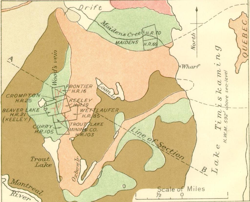
68
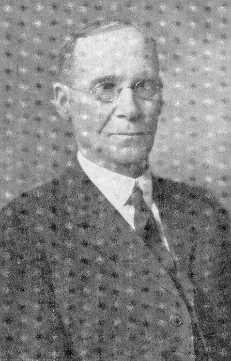
69
70
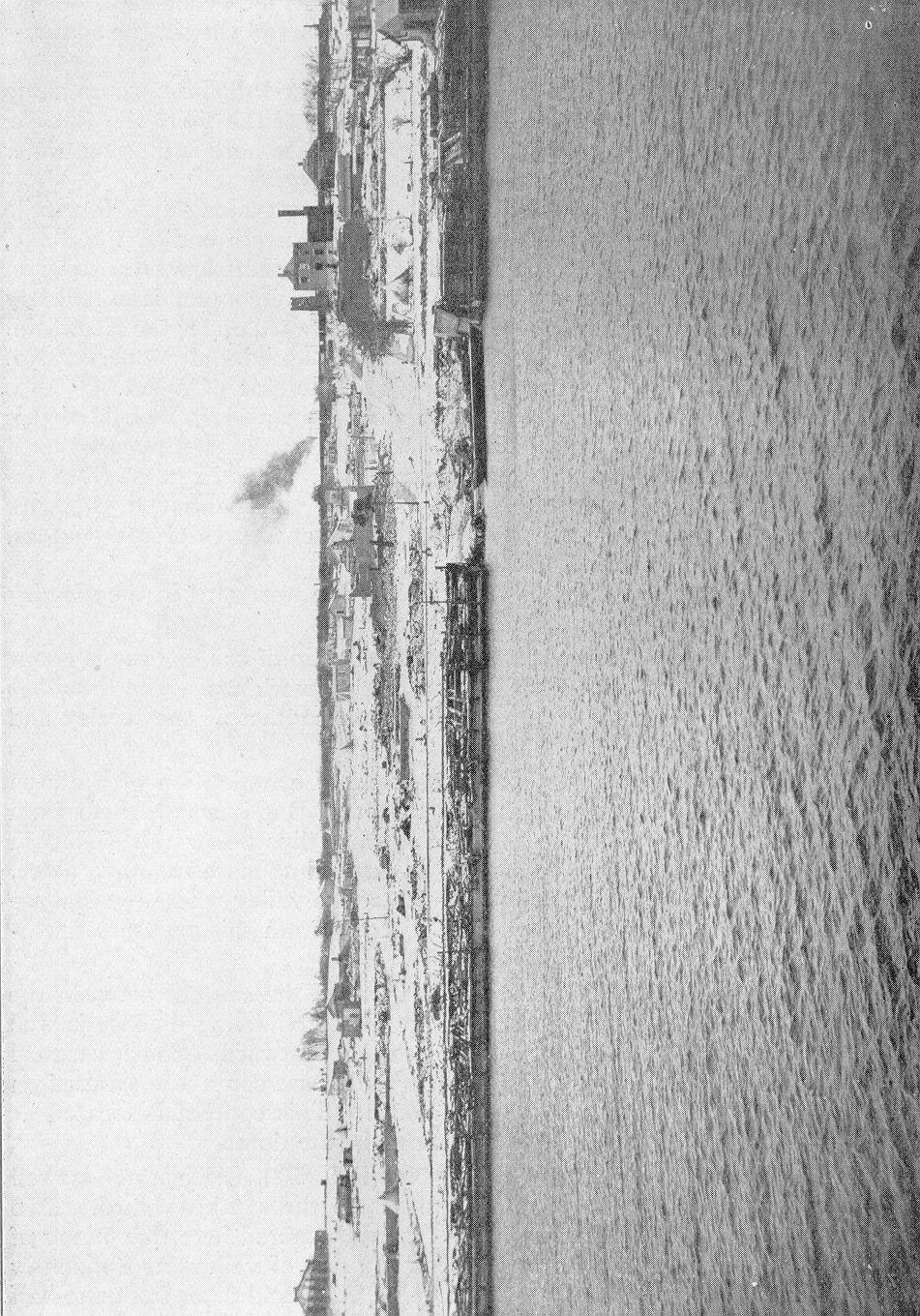
71
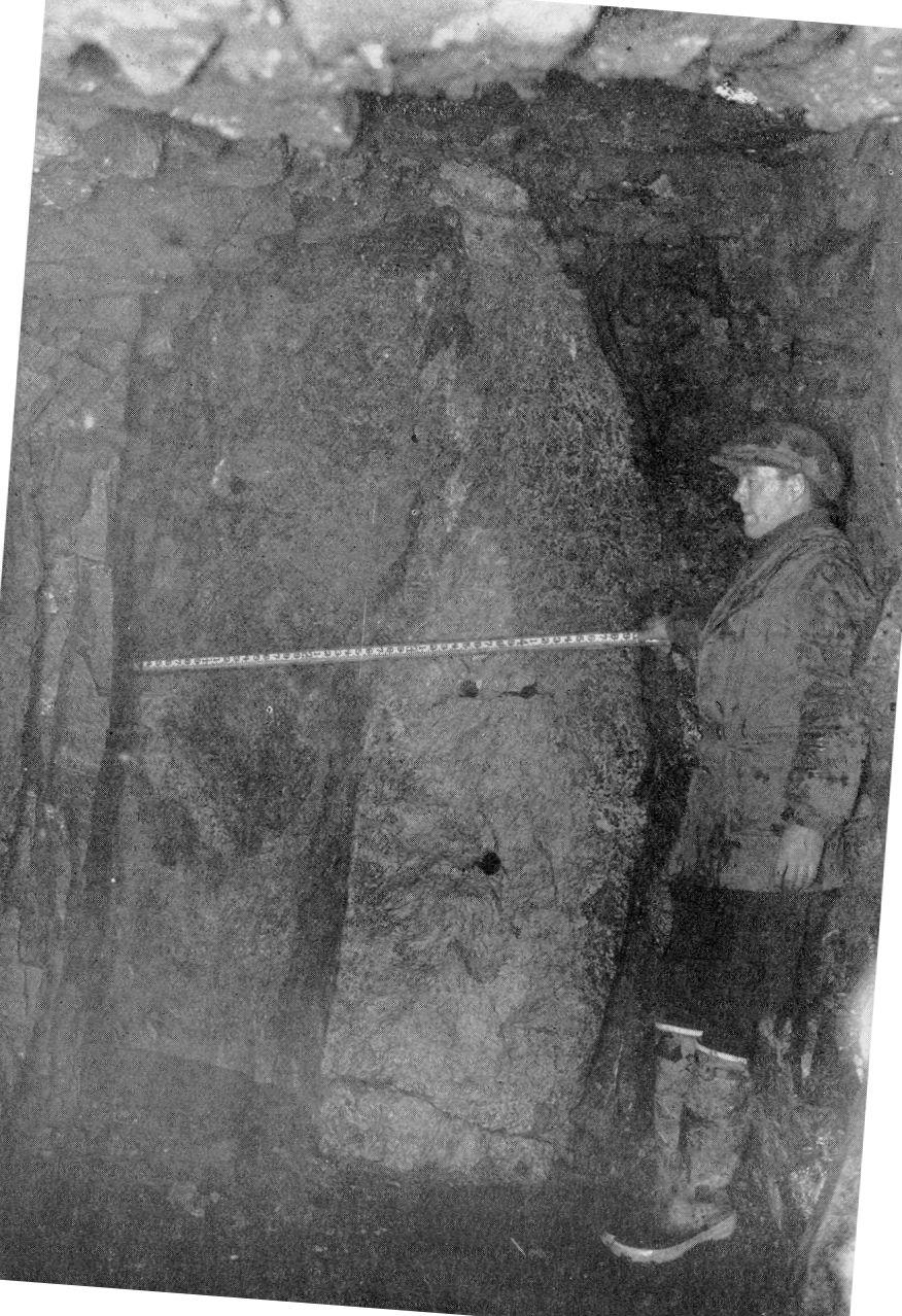
72
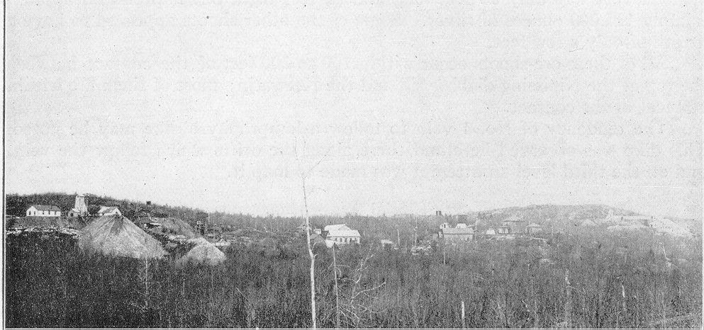
73
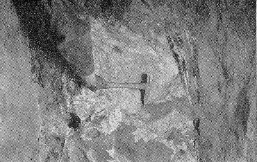
74
75
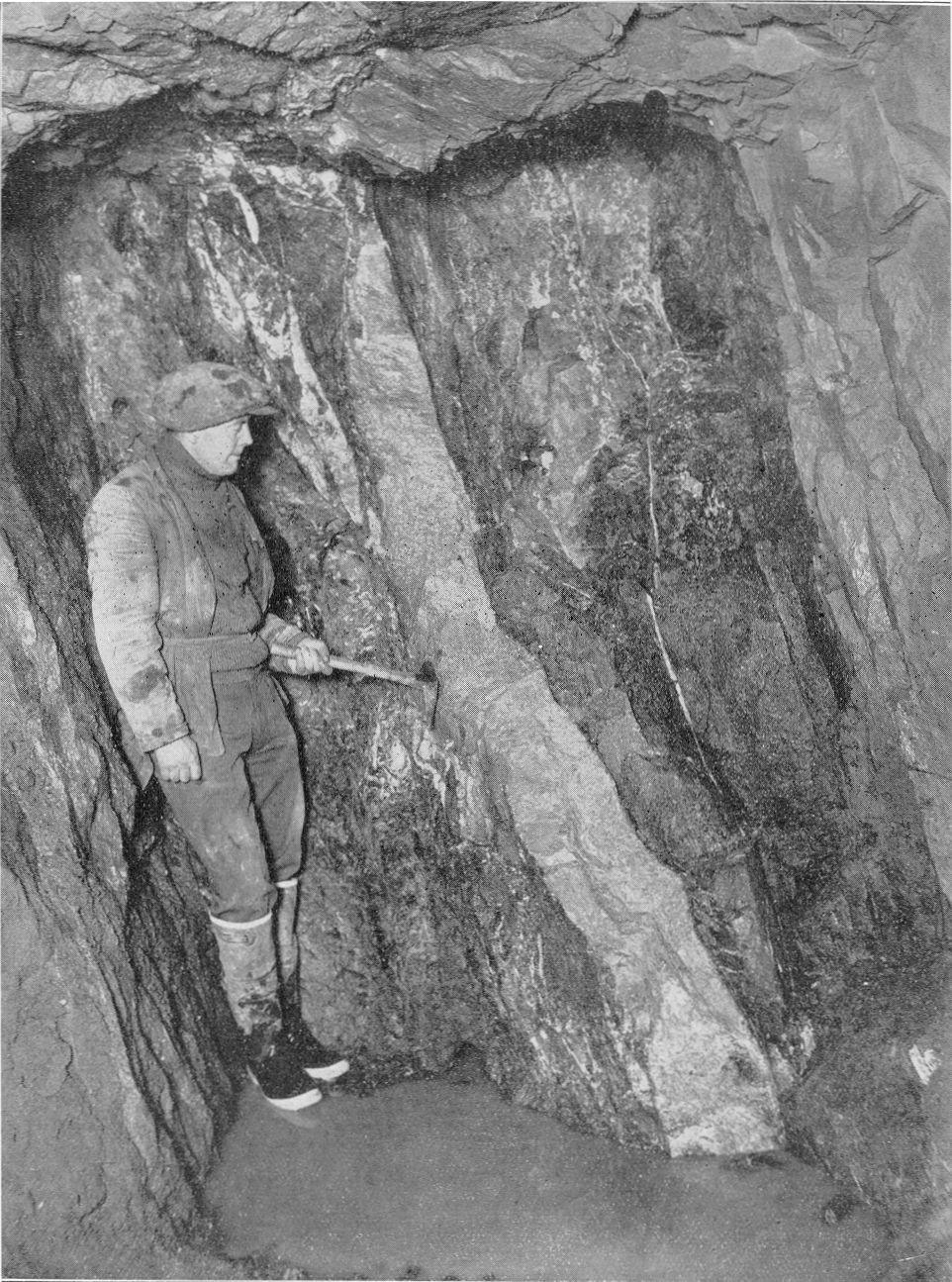
76
Local: (705) Toll Free: , ext (inside Canada, United States) Local: (705) Toll Free: , ext.
 Toll Free: , ext (inside Canada, United States) Local: (705) Toll Free: , ext.") THESE TERMS GOVERN YOUR USE OF THIS DOCUMENT Your use of this Ontario Geological Survey document (the Content ) is governed by the terms set out on this page ( Terms of Use ). By downloading this Content,
THESE TERMS GOVERN YOUR USE OF THIS DOCUMENT Your use of this Ontario Geological Survey document (the Content ) is governed by the terms set out on this page ( Terms of Use ). By downloading this Content,
AGGREGATE RESOURCES OF ONTARIO (ARO) METADATA
 METADATA") AGGREGATE RESOURCES OF ONTARIO (ARO) METADATA GENERAL INFORMATION Official Name of the Data Set or Information Holding: Aggregate Resources of Ontario Acronyms are Used to Identify the Data Set or Information
AGGREGATE RESOURCES OF ONTARIO (ARO) METADATA GENERAL INFORMATION Official Name of the Data Set or Information Holding: Aggregate Resources of Ontario Acronyms are Used to Identify the Data Set or Information
MRD 281. Official Name of the Data Set or Information Holding: Northeastern Ontario Rhyolite Database
 MRD 281 GENERAL INFORMATION Official Name of the Data Set or Information Holding: Northeastern Ontario Rhyolite Database Acronyms are Used to Identify the Data Set or Information Holding: MRD281 Describe
Local: (705) Toll Free: , ext (inside Canada, United States) Local: (705) Toll Free: , ext.
 Toll Free: , ext (inside Canada, United States) Local: (705) Toll Free: , ext.") THESE TERMS GOVERN YOUR USE OF THIS DOCUMENT Your use of this Ontario Geological Survey document (the Content ) is governed by the terms set out on this page ( Terms of Use ). By downloading this Content,
THESE TERMS GOVERN YOUR USE OF THIS DOCUMENT Your use of this Ontario Geological Survey document (the Content ) is governed by the terms set out on this page ( Terms of Use ). By downloading this Content,
THESE TERMS GOVERN YOUR USE OF THIS DOCUMENT
 THESE TERMS GOVERN YOUR USE OF THIS DOCUMENT Your use of this Ontario Geological Survey document (the Content ) is governed by the terms set out on this page ( Terms of Use ). By downloading this Content,
MRD283-REV METADATA. Acronyms are Used to Identify the Data Set or Information Holding: MRD283-REV
 MRD283-REV METADATA GENERAL INFORMATION Official Name of the Data Set or Information Holding: Ambient Groundwater Geochemistry Data for Southern Ontario, 2007 2014 Acronyms are Used to Identify the Data
MRD273-REV METADATA. Acronyms are Used to Identify the Data Set or Information Holding: MRD273-REV
 MRD273-REV METADATA GENERAL INFORMATION Official Name of the Data Set or Information Holding: Ontario Precambrian Bedrock Magnetic Susceptibility Geodatabase for 2001 to 2012 Acronyms are Used to Identify
THESE TERMS GOVERN YOUR USE OF THIS DOCUMENT
 THESE TERMS GOVERN YOUR USE OF THIS DOCUMENT Your use of this Ontario Geological Survey document (the Content ) is governed by the terms set out on this page ( Terms of Use ). By downloading this Content,
MRD 229-Revised METADATA
 GENERAL INFORMATION MRD 229-Revised METADATA Official Name of the Data Set or Information Holding: Till Compositional Database: Investigation of the Overburden Signature of the Caribou Lake Greenstone
MRD 228 METADATA. Official Name of the Data Set or Information Holding: Physiography of Southern Ontario
 MRD 228 METADATA GENERAL INFORMATION Official Name of the Data Set or Information Holding: Physiography of Southern Ontario Acronyms are Used to Identify the Data Set or Information Holding: MRD228 Describe
MRD 207 METADATA DETAIL PAGE
 MRD 207 METADATA DETAIL PAGE The following represents the Basic description of an information holding. To obtain more information about this holding, see the section named Contacts. GENERAL INFORMATION
Introducti on. Land Survey. Geomagnetic Survey. Geomagnetic Results and Interpretati ons - Conclusions and Recommendations C
 m M 42A86SW8281 63.42 PRICE 010 C O H T E H l 42A86SW828I 63.42 PRICE 010C Introducti on Land Survey Geomagnetic Survey Geomagnetic Results and Interpretati ons - Conclusions and Recommendations - - -
GEOPHYSICAL DATA SET (GDS) 1084B METADATA
 1084B METADATA") GEOPHYSICAL DATA SET (GDS) 1084B METADATA GENERAL INFORMATION Official Name of the Data Set or Information Holding: Ontario Airborne Geophysical Surveys, Magnetic Gradiometer and Gamma-Ray Spectrometric
GEOPHYSICAL DATA SET (GDS) 1084B METADATA GENERAL INFORMATION Official Name of the Data Set or Information Holding: Ontario Airborne Geophysical Surveys, Magnetic Gradiometer and Gamma-Ray Spectrometric
Local: (705) Toll Free: , ext (inside Canada, United States) Local: (705) Toll Free: , ext.
 Toll Free: , ext (inside Canada, United States) Local: (705) Toll Free: , ext.") THESE TERMS GOVERN YOUR USE OF THIS DOCUMENT Your use of this Ontario Geological Survey document (the Content ) is governed by the terms set out on this page ( Terms of Use ). By downloading this Content,
THESE TERMS GOVERN YOUR USE OF THIS DOCUMENT Your use of this Ontario Geological Survey document (the Content ) is governed by the terms set out on this page ( Terms of Use ). By downloading this Content,
THESE TERMS GOVERN YOUR USE OF THIS DOCUMENT
 THESE TERMS GOVERN YOUR USE OF THIS DOCUMENT Your use of this Ontario Geological Survey document (the Content ) is governed by the terms set out on this page ( Terms of Use ). By downloading this Content,
Canadian Gold Miner Grab Sample Returns 29.5 Grams per tonne Gold from South Kirkland Project
 Canadian Gold Miner Grab Sample Returns 29.5 Grams per tonne Gold from South Kirkland Project Sudbury, July 27, 2017 Canadian Gold Miner Corp ( CGM, the Company) and Transition Metals Corp. (XTM TSX.V,
THESE TERMS GOVERN YOUR USE OF THIS DOCUMENT
 THESE TERMS GOVERN YOUR USE OF THIS DOCUMENT Your use of this Ontario Geological Survey document (the Content ) is governed by the terms set out on this page ( Terms of Use ). By downloading this Content,
City of Six Project. Gold Mining Property in Downieville, CA. 60 Acres of Claims. Estimated Resource of over 8,800 ounces of Gold
 City of Six Project Gold Mining Property in Downieville, CA 60 Acres of Claims Estimated Resource of over 8,800 ounces of Gold Adjoining the famous Ruby Mine Property Located on a Rich Tertiary Channel
Local: (705) Toll Free: , ext (inside Canada, United States) Local: (705) Toll Free: , ext.
 Toll Free: , ext (inside Canada, United States) Local: (705) Toll Free: , ext.") THESE TERMS GOVERN YOUR USE OF THIS DOCUMENT Your use of this Ontario Geological Survey document (the Content ) is governed by the terms set out on this page ( Terms of Use ). By downloading this Content,
THESE TERMS GOVERN YOUR USE OF THIS DOCUMENT Your use of this Ontario Geological Survey document (the Content ) is governed by the terms set out on this page ( Terms of Use ). By downloading this Content,
We are committed to providing accessible customer service. If you need accessible formats or communications supports, please contact us.
 We are committed to providing accessible customer service. If you need accessible formats or communications supports, please contact us. Nous tenons à améliorer l accessibilité des services à la clientèle.
WESDOME ANNOUNCES HIGH GRADE GOLD DISCOVERY AT KIENA COMPLEX IN VAL D OR QUEBEC
 ` PRESS RELEASE AUGUST 24 2016 TSX:WDO WESDOME ANNOUNCES HIGH GRADE GOLD DISCOVERY AT KIENA COMPLEX IN VAL D OR QUEBEC Toronto, Ontario August 24, 2016 Wesdome Gold Mines Ltd. (TSX: WDO) is pleased to
Marshall Shore Town Park, Liberty, Maine
 Maine Geologic Facts and Localities August, 2005 Marshall Shore Town Park, Liberty, Maine 44 22 33.04 N, 69 21 9.19 W Text by Henry N. Berry IV, Department of Agriculture, Conservation & Forestry 1 Introduction
THE TOPOGRAPHY AND GEOLOGY OF THE GRAND PORTAGE^
 THE TOPOGRAPHY AND GEOLOGY OF THE GRAND PORTAGE^ Few areas within the boundaries of Minnesota are of greater historical interest than the region surrounding the Grand Portage, which long before the first
LUCKY BEN MINE PROJECT SEPTEMBER 2018 UPDATE
 LUCKY BEN MINE PROJECT SEPTEMBER 2018 UPDATE During the first week of July 2018 work was completed by our Geologist, Richard Morris, and support personnel to stake the Lucky Ben vein structure at surface
12 tons of high-grade ore was mined from the No. 1 vein with an average grade of 13 g/t gold, 3,250 g/t silver and 23.3% lead.
 DUNWELL MINE GROUP The Dunwell Mine Group (Dunwell, Dunwell East, Bear River/MM and Silvershot properties), which includes the historic, past-producing Dunwell mine, is located 8 km northeast of Stewart
Amador Canyon Silver Mining Property Lander County, NV
 Amador Canyon Silver Mining Property Lander County, NV Over $1 million worth of exploration and evaluation work performed Favorable drill results including a return of 286 g/ton silver over 12.2 meters
BUREAU OF MINERAL RESOURCES GEOLOGY AND GEOPHYSICS.
 COMMONWEALTH OF AUSTRALIA. DEPARTMENT OF NATIONAL DEVELOPMENT. BUREAU OF MINERAL RESOURCES GEOLOGY AND GEOPHYSICS. RECORDS: 1962/33 GEOLOGY OF THE B.W. IRON CLAIM, HUNDRED OF WATERHOUSE, NORTHERN TERRITORY.
NEWS RELEASE. Evrim announces additional drilling results at Cuale Gold Project in Mexico
 910-850 WEST HASTINGS ST. VANCOUVER, BC, CANADA V6C 1E1 TEL: 604.248.8648 FAX: 604.248.8663 WWW.EVRIMRESOURCES.COM TSX-V: EVM CONTACT: PADDY NICOL OR CHARLES FUNK NEWS RELEASE Evrim announces additional
THESE TERMS GOVERN YOUR USE OF THIS DOCUMENT
 THESE TERMS GOVERN YOUR USE OF THIS DOCUMENT Your use of this Ontario Geological Survey document (the Content ) is governed by the terms set out on this page ( Terms of Use ). By downloading this Content,
We are committed to providing accessible customer service. If you need accessible formats or communications supports, please contact us.
 We are committed to providing accessible customer service. If you need accessible formats or communications supports, please contact us. Nous tenons à améliorer l accessibilité des services à la clientèle.
THESE TERMS GOVERN YOUR USE OF THIS DOCUMENT
 THESE TERMS GOVERN YOUR USE OF THIS DOCUMENT Your use of this Ontario Geological Survey document (the Content ) is governed by the terms set out on this page ( Terms of Use ). By downloading this Content,
The MAPLE BAY PROJECT Copper Silver - Gold
 The MAPLE BAY PROJECT Copper Silver - Gold Good grade and tonnage potential within close proximity to Tidewater The Maple Bay Copper Silver Gold Project covers highly favourable geological host rocks of
Prospecting Report 'S Office i DB Property, B.C. -J Negro Creek Nelson Mining District NTS 82F.050. Operator: Kootenay Gold Inc.
 . '.' I"' i9 12 Prospecting Report 'S Office i DB Property, B.C. -J Negro Creek Nelson Mining District NTS 82F.050 Operator: Kootenay Gold Inc. Owner: Darlene Lavoie Work Performed Summer of 2007 Report
THESE TERMS GOVERN YOUR USE OF THIS DOCUMENT
 THESE TERMS GOVERN YOUR USE OF THIS DOCUMENT Your use of this Ontario Geological Survey document (the Content ) is governed by the terms set out on this page ( Terms of Use ). By downloading this Content,
We are committed to providing accessible customer service. If you need accessible formats or communications supports, please contact us.
 We are committed to providing accessible customer service. If you need accessible formats or communications supports, please contact us. Nous tenons à améliorer l accessibilité des services à la clientèle.
Amboy Iron Mines, Bristol Mountains, San Bernardino County, California. Gregg Wilkerson 2017
 Amboy Iron Mines, Bristol Mountains, San Bernardino County, California Gregg Wilkerson 2017 Acknowledgement and Disclaimer The information in this paper is taken largely from published sources. I have
THESE TERMS GOVERN YOUR USE OF THIS DOCUMENT
 THESE TERMS GOVERN YOUR USE OF THIS DOCUMENT Your use of this Ontario Geological Survey document (the Content ) is governed by the terms set out on this page ( Terms of Use ). By downloading this Content,
LONG LAKE ZINC MINE. Selected References "Zinc and Lead Deposits of Canada'% Geol. Surv. Can., Econ. Geol. Series, No k 8, 1930, pp, H6-151.
 April,1952 31CI8NW8eie 63.3149 OLDEN 010 ^ LONG LAKE ZINC MINE Selected References Alcock, P.J., "Zinc and Lead Deposits of Canada'% Geol. Surv. Can., Econ. Geol. Series, No k 8, 1930, pp, H6-151. Harding,
PROSPECTING REPORT THE WALLACE CLAIM OMENICA MINING DIVISION. 54" x6" 3.d d. for. Reako Exlorat ions Ltd. Wallace Rev. C.G.
 PROSPECTING REPORT ON THE WALLACE CLAIM OMENICA MINING DIVISION 54"44 14 1x6" 3.d d by David A. Howard P.Eng. for Reako Exlorat ions Ltd. Claim Locat ion Wallace Rev. C.G. #1560 Dome Mountain Area 9 3
entire 1.5 meter drift width
 GOLD HILL SUMMARY In 1864 gold fever struck in the south Kootenays east of Cranbrook, British Columbia as placer gold was discovered in the Wild Horse River. What followed was everything one can imagine
CARIBOO - GRIZZLY ZINC PROJECT
 CARIBOO - GRIZZLY ZINC PROJECT The Grizzly Lake or Cariboo Zinc property straddles the gravel Weldwood 8400 logging road in the Grizzly Lake area about 55 kilometres northeast of Likely. Roads constructed
lin iibii i nm l i 31M05SE A.446 GILLIES 010
 ..-... lin iibii i nm l i 31M05SE0892 63A.446 GILLIES 010 t GEOLOGICAL REPORT ON HOUND CHUTE LAKE PROPERTY OF SILVER TOWER MINES LIMITED GILLIES LIMIT COBALT, ONTARIO (p Z A The property is located n Blocks
Pahtavaara Drill Program Intersects 32.8 G/T Gold Over 2.0M And 2.1 G/T Gold Over 18.0M In The Karoliina Zone
 Page 1 of 6 a Pahtavaara Drill Program Intersects 32.8 G/T Gold Over 2.0M And 2.1 G/T Gold Over 18.0M In The Karoliina Zone Jan 11, 2017 Toronto, Ontario, Canada Listed: RUP-TSX-V January 10, 2017 Rupert
COAU PROPERTY LEMHI COUNTY, IDAHO
 COAU PROPERTY LEMHI COUNTY, IDAHO Utah Mineral Resources 447 N 300 W, Suite 3 Kaysville, UT 84037 (801) 544-3421 ojgatten@nae-xploration.com Prepared by: North American Mine Services, LLC. March 21, 2017
ORO GOLD COMPLETES 1200-METRE DRILL CAMPAIGN AT CIMARRON GOLD PROJECT IN ROSARIO MINING DISTRICT, MEXICO
 ORO GOLD COMPLETES 1200-METRE DRILL CAMPAIGN AT CIMARRON GOLD PROJECT IN ROSARIO MINING DISTRICT, MEXICO October 20, 2010 Oro Gold Resources Ltd. ( Oro Gold ) (TSX-V: OGR) reports completion of a 14-hole,
NOA ASSESSMENT HARRIS QUARRY MENDOCINO COUNTY, CALIFORNIA TABLE OF CONTENTS
 NOA ASSESSMENT HARRIS QUARRY MENDOCINO COUNTY, CALIFORNIA TABLE OF CONTENTS Introduction... 1 Scope of Services... 1 Project Location and Description... 1 Geologic Setting... 1 Regional Geology... 1 Site
1 FILMED 1. FILE NO:!..rsrru -* -. GRAND TWO CLAIM
 FILE NO:!..rsrru -* -. GRAND TWO CLAIM REPORT ON 1993 ASSESSMENT WORK GRAND TWO CLAIM REC. NO. 301849 NELSON MINING DIVISION NTS MAP SHEET 82F6/W 49 25'51" NORTH 117 18'08" WEST 1 FILMED 1 AUTHOR: R. Jordan,
ASX announcement. Mylo-Frontier Pilbara Gold Project acquisition. 27 November Summary
 ASX announcement 27 November 2017 Andromeda Metals Limited ABN: 75 061 503 375 Mylo-Frontier Pilbara Gold Project acquisition Corporate details: Summary ASX Code: ADN Cash: $0.546 million (at 30 June 2017)
=%REPORT RECONNAISSANCE OF CHISHOLM LAKE PROSPECT. October 25, 1977
 =%REPORT ON FIELD RECONNAISSANCE OF CHISHOLM LAKE PROSPECT October 25, 1977 Bruce D. Vincent Imperial Oil Limited, Minerals - Coal, CALGARY, ALBERTA CHISHOLM LAKE PROSPECT Introduction The Chisholm Lake
Date Submitted: June General Nature of Report: Examination of Placer Samples
 General Nature of Report: Examination of Placer Samples Claim: Gold Channel, Record Number 3775!8 1 (Gold Channel Placer Property) Mining Division: Cariboo NTS 093 G 09 W and E Latitude 520 23 N' Longitude1210
MARKET UPDATE ON URANIUM AND GOLD PROJECTS
 ASX Announcement 1 March 2011 MARKET UPDATE ON URANIUM AND GOLD PROJECTS HIGHLIGHTS 5,000 metre drilling programme to commence at Rio Puerco uranium project within the next two weeks. Drilling to commence
Queenston intersects Contact Zone on the Pandora Property and new gold zones in Kirkland Lake
 1 Queenston intersects Contact Zone on the Pandora Property and new gold zones in Kirkland Lake TORONTO, Ontario, March 7, 2003. Queenston Mining Inc. (QMI-TSX) reports diamond drill results on its 100%
For personal use only
 ASX ANNOUNCEMENT 31 August 2012 DRILLING SUCCESS CONTINUES AT GUCHAB Near surface copper mineralisation in drill core from GCDD0002 HIGHLIGHTS The pilot programme of diamond drilling at Guchab continues
Novo Resources Corp. Suite West Georgia Street Vancouver, BC V6E 3C9
 Novo Resources Corp. Suite 1980 1075 West Georgia Street Vancouver, BC V6E 3C9 SAMPLING RETURNS HIGH GRADES AT NOVO RESOURCES BLUE SPEC GOLD-ANTIMONY PROJECT VANCOUVER, BC, January 21, 2016 - Novo Resources
For personal use only
 18 April 2018 ASX Announcement DRILLING UNDERWAY AT SLATE DAM GOLD PROJECT HIGHLIGHTS 2nd Phase Drilling Program underway at Slate Dam - 9 RC holes for ~1,000m completed to date Program designed to expand
SUPPLEMENT TO MAGNETOMETER 6 ELECTROMAGNETIC SURVEY REPORT. DATED NOVEMBER l, 1973 CIGLEN INVESTMENTS LIMITED CLAIMS GROUP BAD VERMILLION LAKE AREA
 ^ A R l ^ 1974 010 PROJECTS UNIT SUPPLEMENT TO MAGNETOMETER 6 ELECTROMAGNETIC SURVEY REPORT DATED NOVEMBER l, 1973 CIGLEN INVESTMENTS LIMITED CLAIMS GROUP BAD VERMILLION LAKE AREA DISTRICT OF RAINY RIVER
PROSPECTING REPORT. Broken Hill Property. EVENT # TENURE # Tenure Name: Broken Hill. New Westminster Mining Division Map 092H
 2009-2010 PROSPECTING REPORT Broken Hill Property EVENT # 4514071 TENURE # 600988 Tenure Name: Broken Hill New Westminster Mining Division Map 092H Central Coordinate Reference 121 24 26.2 W Longitude
Great Atlantic Rock Samples Return up to 5.8 oz. / ton Gold Golden Promise Property in Central Newfoundland
 Great Atlantic Rock Samples Return up to 5.8 oz. / ton Gold Golden Promise Property in Central Newfoundland FOCUSED ON EXPLORING ATLANTIC CANADA (TSXV : GR) (FRA: PH01) VANCOUVER, British Columbia August
EXPLORATION NEWS RELEASE MAGISTRAL DISTRICT: MORE GROWTH, MORE GOLD, MORE SILVER
 EXPLORATION NEWS RELEASE MAGISTRAL DISTRICT: MORE GROWTH, MORE GOLD, MORE SILVER.1 OPT GOLD OVER 6 FT. 5.6 OPT SILVER EQUIVALENT OVER 65 FT. INCLUDING 13.6 OPT SILVER EQUILALENT OVER 15 FT. Denver, Colorado
OEOMAQNETIC SURVEI QUIBORD TOWNSHIP GROUP #2 HOLLINGER CONSOLIDATED GOLD MINES, LTD.
 OEOMAQNETIC SURVEI QUIBORD TOWNSHIP GROUP #2 HOLLINGER CONSOLIDATED GOLD MINES, LTD. 42Ae9SE0268 63.1502 GUIBORD (711(71 Introduction During the period January 5 - February 26, 1965, a magnetometer survey
Fletcher Junction Project Technical Update December 18, 2008
 Fletcher Junction Project Technical Update December 18, 2008 Disclaimer Warning! The business of Gold Exploration can be FUN, but it can also be hazardous to your physical, emotional, spiritual and financial
A Geological Tour of Tumbledown Mountain, Maine
 Maine Geologic Facts and Localities April, 1998 A Geological Tour of Tumbledown Mountain, Maine 44 45 3.21 N, 70 32 50.24 W Text by Robert G. Marvinney, Department of Agriculture, Conservation & Forestry
DISTRICT op TEMISKAMING
 41P10NE0040 63A.458 NICOL 010 A REPORT ON Till; GEOLOGICAL SO RV l: Y OF Till; CLAIMS 01 s INTIKNATIONAL MINli SbKVJCBS LTD TORONTO IN NICOL TOWNSHIP MONTREAL RIV1R MINING DIVISION DISTRICT op TEMISKAMING
compietea since tnat date, and wnicn comprisea btage I ot tne recommended
 compietea since tnat date, and wnicn comprisea btage I ot tne recommended four-stage program. GEOLOGY & MINERALIZATION The property situate6 on the southeast slope of Nickel Plate Mtn., and within the
POTENTIAL OF THE DONGWE COPPER GOLD PROJECT
 POTENTIAL OF THE DONGWE COPPER GOLD PROJECT By Nathan Sabao, P.Geo. September 2015 1 TABLE OF CONTENTS Page 1.0 EXECUTIVE SUMMARY 1 2.0 LOCATION 2 3.0 ACCESS 2 4.0 GEOLOGY 3 5.0 PREVIOUS DRILLING 5 6.0
THESE TERMS GOVERN YOUR USE OF THIS DOCUMENT
 THESE TERMS GOVERN YOUR USE OF THIS DOCUMENT Your use of this Ontario Geological Survey document (the Content ) is governed by the terms set out on this page ( Terms of Use ). By downloading this Content,
We are committed to providing accessible customer service. If you need accessible formats or communications supports, please contact us.
 We are committed to providing accessible customer service. If you need accessible formats or communications supports, please contact us. Nous tenons à améliorer l accessibilité des services à la clientèle.
GEOLOGY Warren Mining District Idaho County, Idaho March SlI4HARY
 r?..:. F-_.,'.': t.,.. I ~ j. ii lucky BEN motp GEOLOGY Warren Mining District Idaho County, Idaho March 1984 SlI4HARY.., The Lucky Ben Croup of claims cover a gold prospect located in the Wdrren Mining
Elephant Mountain, Alaska Intrusive Related Gold Project July Option to Earn 100%
 Elephant Mountain, Alaska Intrusive Related Gold Project July 2018 Option to Earn 100% CORPORATE Corporate DISCLOSURE Disclosure The information contained herein, while obtained from sources which we believe
2. The latter two intersections occur outside the presently defined mineral resource.
 Avidian Drills 67 m of 4.93 g/t Au, includes 39.8 m of 7.54 g/t Au, at Golden Zone Property, Alaska & Discovers New Zone Northeast of the Breccia Pipe Deposit (Toronto, Ontario January 18, 2018) Avidian
Answers: Internal Processes and Structures (Isostasy)
") Answers: Internal Processes and Structures (Isostasy) 1. Analyse the adjustment of the crust to changes in loads associated with volcanism, mountain building, erosion, and glaciation by using the concept
Answers: Internal Processes and Structures (Isostasy) 1. Analyse the adjustment of the crust to changes in loads associated with volcanism, mountain building, erosion, and glaciation by using the concept
BOREAL EXPANDS DISCOVERY ZONE OF HIGH-GRADE ZINC, SILVER AND LEAD MINERALIZATION AT GUMSBERG PROJECT IN SWEDEN
 BOREAL EXPANDS DISCOVERY ZONE OF HIGH-GRADE ZINC, SILVER AND LEAD MINERALIZATION AT GUMSBERG PROJECT IN SWEDEN Vancouver, B.C., March 4, 2019. Boreal Metals Corp. ( Boreal or the Company ) (TSXV:BMX) is
THESE TERMS GOVERN YOUR USE OF THIS DOCUMENT
 THESE TERMS GOVERN YOUR USE OF THIS DOCUMENT ISBN 978-1-4606-4599-4 (DVD) ISBN 978-1-4606-4598-7 (zip file) Your use of this electronic information product ( EIP ), and the digital data files contained
For Sale - 56 Acre Sandstone Quarry State Route 511, Oberlin/Kipton, OH 44075
 14647 State Route 511, Oberlin/Kipton, OH 44075 56 ACRES Vermilion Rd Gifford Rd Haigh Rd 44 Summary The Kipton sandstone quarry is included in 56 acre tract owned by Terry A. Johnson, of Huron, Ohio.
We are committed to providing accessible customer service. If you need accessible formats or communications supports, please contact us.
 We are committed to providing accessible customer service. If you need accessible formats or communications supports, please contact us. Nous tenons à améliorer l accessibilité des services à la clientèle.
PROSPECTING REPORT. Silver Dollar Property. EVENT # TENURE # Tenure Name: GPEX Silver Dollar
 2008-2009 PROSPECTING REPORT Silver Dollar Property EVENT # 4267989 TENURE # 555462 Tenure Name: GPEX Silver Dollar Similkameen Mining Division Map 092H Central Coordinate Reference 120 06 26.9 W Longitude
EMU NL Annual General Meeting
 EMU NL Annual General Meeting Big Targets in the Maricunga Gold Belt Encouraging Results Getting the job done 9 November 2017 Investment proposition EMU is an ASX listed company seeking to deliver tangible
THESE TERMS GOVERN YOUR USE OF THIS DOCUMENT
 THESE TERMS GOVERN YOUR USE OF THIS DOCUMENT Your use of this Ontario Geological Survey document (the Content ) is governed by the terms set out on this page ( Terms of Use ). By downloading this Content,
SIXTH SCHEDULE REPUBLIC OF SOUTH SUDAN MINISTRY OF PETROLEUM, MINING THE MINING (MINERAL TITLE) REGULATIONS 2015
 REGULATIONS 2015") SIXTH SCHEDULE REPUBLIC OF SOUTH SUDAN MINISTRY OF PETROLEUM, MINING THE MINING ACT, 2012 THE MINING (MINERAL TITLE) REGULATIONS 2015 Guidelines should be prepared by the Directorate of Mineral Development
SIXTH SCHEDULE REPUBLIC OF SOUTH SUDAN MINISTRY OF PETROLEUM, MINING THE MINING ACT, 2012 THE MINING (MINERAL TITLE) REGULATIONS 2015 Guidelines should be prepared by the Directorate of Mineral Development
CHAMPION IRON REPORTS EXPLORATION RESULTS AT POWDERHORN PROJECT, NEWFOUNDLAND
 PRESS RELEASE CHAMPION IRON REPORTS EXPLORATION RESULTS AT POWDERHORN PROJECT, NEWFOUNDLAND Confirmed Continuity of High-Grade Zinc Zone and Addition of Gold to the Expanded Copper Zone Montreal, March
SUMMARY REPORT. ESSAR STEEL ALGOMA INC. 105 West Street, Sault Ste. Marie, Ontario, Canada P6A 7B4
 SUMMARY REPORT IRON LAKE PROPERTY Keating and Keating Additional Townships, Ontario, Canada ESSAR STEEL ALGOMA INC. 105 West Street, Sault Ste. Marie, Ontario, Canada P6A 7B4 Date: March 18, 2013 Prepared
... Discovery : Year 1958 Uncertainty: Method : Decouverte: Annee Incertitude: Page/Page 1 of/de 2
 Page/Page 1 of/de 2 Objet localise: Latitude/Latitude: 56O34'35 Longitude/Longitude: 130 41'15. UTM zone/rbgion UTM: 9 UTM North./UTM Nord: 6271294 UTM East./UTM Est: 396328 Mining division/division miniere:
THESE TERMS GOVERN YOUR USE OF THIS DOCUMENT
 THESE TERMS GOVERN YOUR USE OF THIS DOCUMENT Your use of this Ontario Geological Survey document (the Content ) is governed by the terms set out on this page ( Terms of Use ). By downloading this Content,
AiG ON THE EASTRIM mm. Record number KENNJZDY LAKE AREA - ALBERNI MINING DIVISION Map 92Fl3 W
 ON THE EASTRIM mm CLAIM Record number 3799 19 KENNJZDY LAKE AREA - ALBERNI MINING DIVISION Map 92Fl3 W 125" 23' West Lbngitude - 49" 09' North Latitude Walter GUPPY August ZO;i;! t I : AiG272002 TABLE
RE~ORT ON. J.F.V. MILLAR, P. Eng. GEOCHEMICAL SURVEY TIMBASKET AND MOGUL MINERAL CLAIMS. Kinbasket Lake, B. C. 51 degrees 118 degrees N.E.
 RE~ORT ON GEOCHEMICAL SURVEY TIMBASKET AND MOGUL MINERAL CLAIMS Kinbasket Lake, B. C. 51 degrees 118 degrees N.E. J.F.V. MILLAR, P. Eng. Lease held by J.F.V. MILLAR Work done Sept. 22 - Oct. 3, 1967. REPORT
Cape Breton Island Mineral Inventory Studies: A Sandstone Quarry Development Opportunity at Graham River (NTS 11F/14), Inverness County
, Inverness County") Report of Activities 2001 23 Cape Breton Island Mineral Inventory Studies: A Sandstone Quarry Development Opportunity at Graham River (NTS 11F/14), Inverness County G. J. DeMont and J. E. Hawken Compilation
Report of Activities 2001 23 Cape Breton Island Mineral Inventory Studies: A Sandstone Quarry Development Opportunity at Graham River (NTS 11F/14), Inverness County G. J. DeMont and J. E. Hawken Compilation
4J)SESSMEN'I' REPORT BRANCH. cc" FILE No: ASSESSMENT REPORT VICTORIA MINING DIVISION. Latitude 123O SF' Longitude 48O S5'
SESSMEN'I' REPORT BRANCH. cc FILE No: ASSESSMENT REPORT VICTORIA MINING DIVISION. Latitude 123O SF' Longitude 48O S5'") ASSESSMENT REPORT - ON THE ORM 1 MINERAL CLAIM VICTORIA MINING DIVISION NTS 92B cc" Latitude 123O SF' Longitude 48O S5' 3-2. w N C FILE No: @&@LOGI.CAL BRANCH 4J)SESSMEN'I' REPORT Date : June 1, 1990 TABLE
ASSESSMENT REPORT - ON THE ORM 1 MINERAL CLAIM VICTORIA MINING DIVISION NTS 92B cc" Latitude 123O SF' Longitude 48O S5' 3-2. w N C FILE No: @&@LOGI.CAL BRANCH 4J)SESSMEN'I' REPORT Date : June 1, 1990 TABLE
HERON ENTERS OPTION TO PURCHASE A1 GOLD MINE, EASTERN VICTORIA
 ASX Release 13 AUGUST 2009 HERON ENTERS OPTION TO PURCHASE A1 GOLD MINE, EASTERN VICTORIA Heron Resources Limited (ASX:HRR, Heron) is pleased to announce it has purchased an Option (Option) to acquire
PRESS RELEASE. DUBUISSON NORTH DRILLING CUTS g/t AU OVER 5.0 METRES NEW S50 EAST DISCOVERY, 3.39 g/t AU OVER 25.9 METRES
 PRESS RELEASE DUBUISSON NORTH DRILLING CUTS 45.05 g/t AU OVER 5.0 METRES NEW S50 EAST DISCOVERY, 3.39 g/t AU OVER 25.9 METRES Toronto, Ontario November 19, 2014 Wesdome Gold Mines Ltd (TSX: WDO) today
KIRKLAND LAKE GOLD EXPANDS NEW HIGH-GRADE ZONE BELOW TAYLOR MINE, REPORTS MINERALIZED EXTENSIONS ALONG STRIKE AND AT DEPTH
 KIRKLAND LAKE GOLD EXPANDS NEW HIGH-GRADE ZONE BELOW TAYLOR MINE, REPORTS MINERALIZED EXTENSIONS ALONG STRIKE AND AT DEPTH New gold zone intersected 500 metres ( m ) below existing mining and mine infrastructure
CONTANGO ORE, INC. Contango ORE Announces Results of 2012 Exploration Program
 CONTANGO ORE, INC. NEWS RELEASE Contango ORE Announces Results of 2012 Exploration Program December 6, 2012 HOUSTON, TEXAS Contango ORE, Inc. (CTGO.PK) announced today the preliminary results on a portion
MEMO. TO: Dennis Lapoint CC: FROM: Eriaan Wirosono DATE: April, 20 th 2014 SUBJECT: Exploration activity report March-April 2014_EW
 TO: Dennis Lapoint CC: FROM: Eriaan Wirosono DATE: April, 20 th 2014 SUBJECT: Exploration activity report March-April 2014_EW MEMO 1. Highlights and Productivity Overview pan sampling on target Areas 1
Photo 119. Ripple marks in the Gordon Lake Formation. Highway 639 at the entrance to Laurentian Lodge.
 in particular of the Bruce Limestone by the Nipissing Diabase, has produced the rocks known as skarns (page 162). Regional metamorphism, particularly in the Massey - Whitefish Falls area, has produced
Pratice Surface Processes Test
 1. The cross section below shows the movement of wind-driven sand particles that strike a partly exposed basalt cobble located at the surface of a windy desert. Which cross section best represents the
GOLDEN MINERALS IDENTIFIES HIGH GRADE GOLD AND SILVER VEINS AT YOQUIVO
 GOLDEN MINERALS IDENTIFIES HIGH GRADE GOLD AND SILVER VEINS AT YOQUIVO GOLDEN, CO /GLOBE NEWSWIRE/ October 31, 2018 Golden Minerals Company ( Golden Minerals, Golden or the Company ) (NYSE American and
THESE TERMS GOVERN YOUR USE OF THIS DOCUMENT
 THESE TERMS GOVERN YOUR USE OF THIS DOCUMENT Your use of this Ontario Geological Survey document (the Content ) is governed by the terms set out on this page ( Terms of Use ). By downloading this Content,