FIFTH YEAR ASSESSMENT REPORT ON LICENCE 15809M. GEOCHEMISTRY and PROSPECTING. on the ENGLISH RIDGE PROPERTY, NTS 1N/06
|
|
|
- Meryl Bates
- 5 years ago
- Views:
Transcription
1
2
3 FIFTH YEAR ASSESSMENT REPORT ON LICENCE 15809M of GEOCHEMISTRY and PROSPECTING on the ENGLISH RIDGE PROPERTY, NTS 1N/06 MARYSVALE, CONCEPTION BAY, NEWFOUNDLAND Submitted by (License Holder) JASON WHITE Work Conducted: May 2009 Total Expenditures: $ Total Claims: 5 total Date: June 14th,
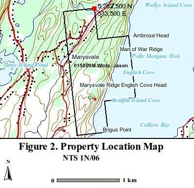
4 TABLE OF CONTENTS 1. INTRODUCTION 3 2. PROPERTY LOCATION AND ACCESS 3 3. CLAIM STATUS 3 4. HISTORY AND PREVIOUS WORK 3 5. REGIONAL AND LOCAL GEOLOGY 5 6. EXPLORATION PROGRAM CONCLUSIONS AND RECOMMENDATIONS 7 APPENDICES APPENDIX I LIST OF EXPENDITURES 8 APPENDIX II LIST OF PERSONAL 8 APPENDIX III GEOCHEMICAL RESULTS 9 APPENDIX IV REFERENCES 12 LIST OF FIGURES FIGURE 1. PROPERTY LOCATION MAP 4 FIGURE 2. CLAIM LOCATION MAP 4 FIGURE 3. SAMPLE LOCATION MAP 6 2
5 1. INTRODUCTION This report encompasses the exploration activities on the English Ridge Property in the area of the sedimentary unit to the south west of the main basalt hosted copper prospect during May Yours Truly Jason D. White June 14th, PROPERTY LOCATION AND ACCESS The property is located on the west side of Colliers Bay, Conception Bay (Figure1) with road access from the towns of Marysvale and Colliers (Figure 2). The northeast corner having the U.T.M. Coordinates of 5,262,500 N, 333,500 E of Zone 22, NTS 1N/06, NAD 27. Access to the property can be obtained from Route 60, local community roads by boat from Colliers Bay.(Figure 2). 3. CLAIM STATUS The English Ridge Property consists of 5 claims in mineral license 15809M, replacing mineral licence 10598M, staked in HISTORY AND PREVIOUS WORK 1842 Jukes records an unconformity of the Cambrian & Precambrian rocks of the Avalon Peninsula (Jukes, 1842) 1850's 10m adit driven at sea level in English Cove; an open cut and shaft at Crows Gulch; 30m shaft sunk at Colliers River; and 55m shaft had been sunk at Turks Gut. (Martin,1980) 1919 Buddington describes the Marysvale Fault (Buddington,1919 page 455) 1957 McCartney maps the Holyrood area for the Geological Survey of Canada (McCartney, 1957) 1967 McCartney produces Memoir 341 and map of the Holyrood & Whitborne areas for the Geological Survey of Canada, locally describes the Mn occurrences and maps the geology of the local area of Colliers Bay. (McCartney, 1967) 1980's An Honor's student studies the paleo magnetism of the conglomerate and flow top breccia in the Marysvale area with results indicating an intrusive body. (Hodych,2007) 1990's O'Brien studies the 1N/06 and 1N/07 areas, bounded by the Topsail Fault to the east and the Marysvale Fault to the West and comments on the copper occurrences, including a newly discovered algal sedimentary copper in the area. (O'Brien,1996; O'Brien,2002) 1996 Morgan studies English Cove area as part of thesis for Honors degree in geology (Morgan,1996) Wilton writes report for Copper Hill and describes a disseminated copper occurrence near the English Cove adit, assays were reported grading up to 33.4% Cu and 7.9 oz/t Ag from grab samples and a 10m vein chip sample grading 1.45% Cu and 0.83 oz/t Ag (Wilton,1998). 3
6 4
7 5. REGIONAL AND LOCAL GEOLOGY The English Ridge property is part of the Avalon Zone of Eastern Newfoundland. This zone occupies the northern most portion of the Appalachian Avalonian Belt, a succession of late Proterozoic age volcanic, plutonic and volcanic sedimentary rocks, extending from the Avalon Peninsula, through the Atlantic provinces to the Carolinas and Northern Georgia, a distance of 3000 km (Williams, 1979). Regional Geology The region is mapped by King as (King,1988): Adeyton Group: Chamberlains Brook formation: green and red shale or slate and thin limestone beds; manganiferous bed near base; spilitic cherty pillow lava. Brigus Formation: red, pink and green shale or slate and thin limestone beds; basal conglomerate where formation rests directly on Precambrian rocks. Harbour Main Group: member Hhb: Green to purple basaltic flows and pyroclastic rocks, clastic sedimentary rocks and gabbro Conception Group: Drook Formation: green siliceous siltstone and sandstone; silicified tuff. West of the Marysvale fault the Drook formation of the Conception group appears; east of the fault the basalts of the Harbour Main Group are overlain by the sedimentary Adeyton group. The exact location and nature of the Marysvale fault is obscured with overburden. 5
8 6
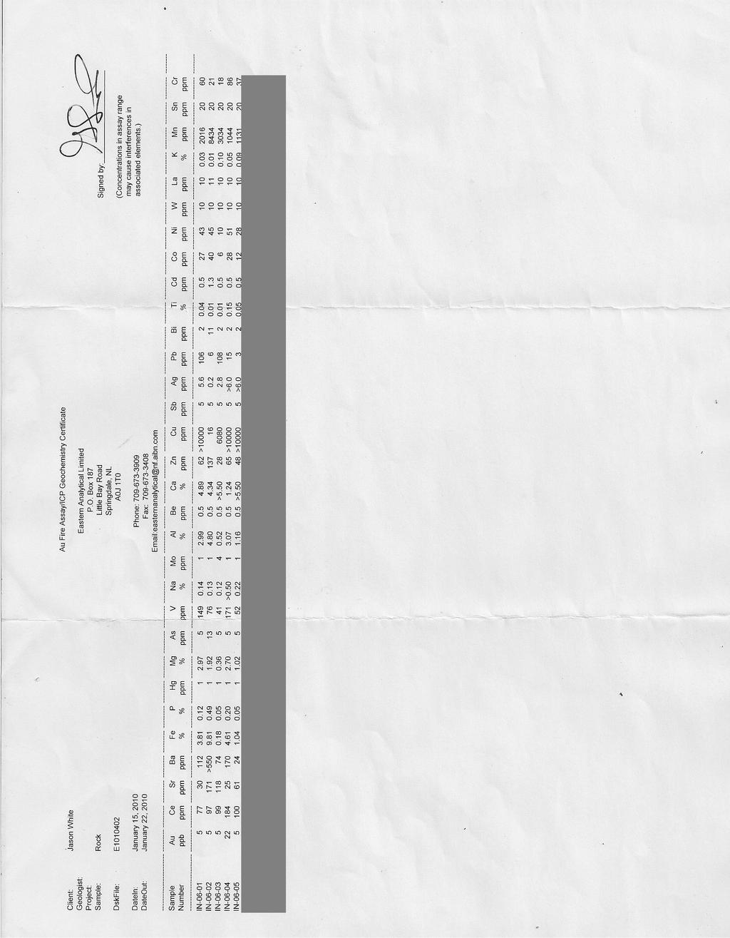
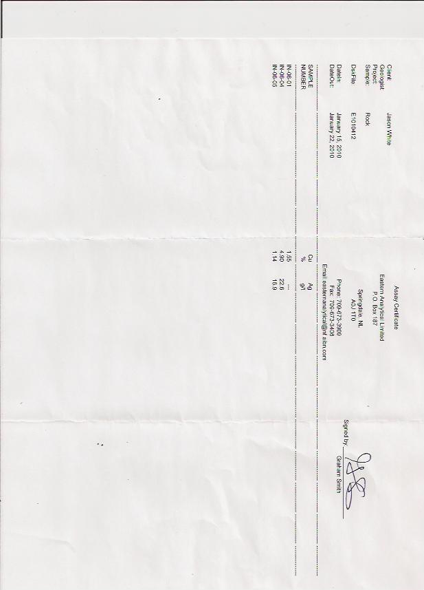
9 6. EXPLORATION PROGRAM 2009 The 2009 exploration program consisted of one day prospecting on mineral licence 15809m, specifically examining the sedimentary unit outcrop to the south west of the main English Ridge Copper prospect accompanied with a geochemical survey of selected samples from the licence. An examination of the sedimentary outcrop south west of the English Ridge copper occurrence shows a manganese containing layer, which also contains significant barium (sample 1N-06-02), this may be an original evaporate type sedimentary deposit, or it may be due to secondary replacement. The barium containing layer is located above the bright red hematized sandstone which lies unconformably over the basalt unit. Sample Description and location (see Figure 3): Location 1: (approximately) 333,100 E, 5,261,150 N 1N Oxidized black earthy Mn stained earthy sedimentary layer. 1N Grey reduced limestone with disseminated chalcocite, float Location 2: 333,377 E, 5,261,088 N 1N West of the shear (land side), chalcocite in calcite / basalt breccia. 1N Malachite stained chalcocite / bornite in a narrow shear (5 to 10 cm in thickness). 1N East of shear (water side), chalcocite in vesicular bassalt, adjacent to the shear, appears to have been shallow test pits in this unit (approximately 1 x 6 m vertical, 0.5 m deep), possibly during the exploration in the 1860's. 7. CONCLUSIONS AND RECOMMENDATIONS In conclusion, the English Ridge property contains a prospective environment for both sedimentary and volcanic type deposits of copper, silver, barite and manganese; further work is required to determine the nature and extent of each type. A continuation of the mapping and prospecting program is recommended, with the focus of exploration by boat at tide level, further exploration of the sedimentary unit, and to define the known copper prospect by diamond drilling. 7
10 APPENDIX I LIST OF EXPENDITURES Expense Report Writing Field Work Meals Fuel / Auto Assay Sample prep ICP-30 + Au Ore Grade Amount Cost per unit 3 days 4 days 4 days 1 trips $ $ $20 / person / day $60 / trip (one day) $6.85 $21.50 $11.25 Subtotal Administration 15% Total APPENDIX II Total cost $ $ $80.00 $60.00 $34.25 $ $56.25 $1, $ $1, LIST OF PERSONAL Name Jason D. White 23 Emma's Pl. CBS, NL. Darwin White 23 Emma's Pl. CBS, NL. Norm Power Mt. Pearl, NL. Joe Lee 13 Albany Pl St. John's, NL. 8
11 APPENDIX III GEOCHEMICAL RESULTS 9
12 10
13 11
14 APPENDIX IV REFERENCES Batterson, M. 1995: Landscapes of Newfoundland and Labrador, A Collection of Aerial Photographs. Government of Newfoundland and Labrador, Report : Till Geochemistry of the Central Avalon and Bay de Verde Peninsulas, Geological Survey, Government of Newfoundland and Labrador department of Natural Resources. Open File NFLD/ Buddington, A.F. 1919: Pre-Cambrian Rocks of Southeast Newfoundland; j. Geol., Vol. 27, pg Carr, G.F. 1958: The Industrial Minerals of Newfoundland; Mines Branch, No. 855 Dale, N.C. 1915: The Manganese Deposits of Conception and Trinity Bays, Newfoundland. PhD. Dissertation, Princeton Geological Survey of Canada 1971: Map 4524G, Holyrood, Geophysical Series (Aeromagnetic) Hodych, J., PhD. 2007: Personal communication. Howley, J.P. 1880: List of Newfoundland Minerals (of the Newfoundland Geological Survey), Reprinted from No. 17 Mineralogical Magazine, July Hutchinson, R.D. 1953: Geological Survey of Canada, Memoir 275. Geology of the Harbour Grace Map-Area, Newfoundland. Jukes, J.B. 1842: Excursions in and about Newfoundland during the years 1839 and 1940 King, A.F. 1988: Geology of the Avalon Peninsula, Newfoundland (parts of 1K, 1L, 1M, 1N and 2C). Newfoundland Department of Mines, Mineral Development Division, Map Macaulay, R.M. 1944: Brigus Manganese. Brigus, Conception Bay, Newfoundland. (1N/11(25)) Martin,W. 1980: Once Upon a Mine: The Story of Pre-Confederation Mines on the Island of Newfoundland. Special Volume 26, The Canadian Institute of Mining and Metallurgy. McCartney, W.D. 1954: Holyrood Map 54-3, Geological Survey of Canada 1967: Geology of the Witborne Map Arge, Geological Survey of Canada, Memoir 341 Morgan, J.A. 1996: A Documentation and Study of Vein Hosted Base Metal Deposits on the Avalon Peninsula, Newfoundland. Unpublished BSc. (Hons.) Dissertation, Memorial University of Newfoundland. Murray, A. and Howley, J.P. 1881a: Geological Survey of Newfoundland; London 1881b: Map of the Avalon Peninsula; Geological Survey of Newfoundland 1882: Report of Progress for the Year 1881, Geological Survey of Newfoundland Natural Resources Canada 1943: Ore Dressing and Metallurgical tests on Manganese ore from Brigus, reports No and
15 Nixon, G.T. 1979: Late Precambrian Ash-Flow Tuffs and Associated Rocks of the Hr Main Group Near Colliers. Canadian Journal of Earth Sciences Vol. 16, No. 1; Pages (1N/06/0092) O`Brien, S. 1996: Preliminary Investigation of Neoproterozoic (Avalonian) Rocks, Northeastern Holyrood (NTS 1N/6) Map Area: Notes on Geology, Mineralization and Mineral Exploration Potential. In Current Research (1996), Newfoundland Department of Natural Resources, Geological Survey,Report 96-1, Pages : Late Neoproterozioc geology of the Central Avalon Peninsula, Newfoundland, With an overview of Mineralization and Hydrothermal Alteration. Current Research (1997) Newfoundland Department of Mines and Energy, Geological Survey, Report 97-1, Pages : New Insights Into the Neoproterozoic Geology of the Central Avalon Peninsula (Parts of Map Areas 1N/6, 1N/7 and 1N/13), Eastern Newfoundland. Current Research (2001) Newfoundland Department of Mines & Energy Geological Survey, Report , Pages : A Note on Neoproterozoic Gold, Early Paleozoic Copper and Basement Cover Relationships on the Margins of the Holyrood Horst, Southeastern Newfoundland. Current Research (2002) Newfoundland Department of Mines and Energy Geological Survey, Report 02-01, Pages Scott, J.W. 1952: The Cambrian Manganese Deposits of Southeastern Newfoundland, GSC. Snelgrove, A.K., and Baird, D.M. 1953: Mines &Mineral resources of Newfoundland; Geological survey of Newfoundland, Information Circular No. 4 Spearman, C. 1941: Report on a Manganese deposit near Brigus, Conception Bay; Private Report, GSC Sudess, R.S. 1940: Report on Manganese deposits in Conception Bay, GSC Taylor, S.W. 1979: Geology and Mineral Potential of the Avalon Zone and Granitoid Rocks of Eastern Newfoundland. Mineral Development Division, Department of Mines and Energy, Government of Newfoundland & Labrador. Report White, J.D. 2006: First Year Assessment Report for Mineral Licence 10598m 2007: Second Year Assessment Report for Mineral Licence 10598m Wiseman, R., and Spearman, C. 1942: Report on Brigus Head Manganses; Geological Survey of Newfoundland Wilton, D.H.C,PhD., P.Geo. 1998:First year Mineral Assessment Report on Geological, Geophysical and Prospecting surveys for Turks Gut Property, Newfoundland. For Copper Hill Resources Ltd. Unpublished (1N/0718) Williams, H. 1979: Applacial Orogen in Canada. Canadian Journal of Earth Sciences: 16, pg
First Year Assessment Report on Licence 18084m & 18066m. Prospecting. on the. Crows Gulch Property, NTS 1N/06
 First Year Assessment Report on Licence 18084m & 18066m of Prospecting on the Crows Gulch Property, NTS 1N/06 Marysvale, Conception Bay, Newfoundland and Labrador Submitted by Jason D. White (License Holder)
%+ '$# $) %, %*$ " $ $ ' %' !()'-!" %( %"%! " *'+ - % %$! $)! " $)!" !$ ' "! )( ! $ '%& ')- % % "!#( (( ((# $) ' ) ((* & *# ' % %"*# ( !!
 %, %*$ $ $ ' %' !()'-! %( %%! *'+ - % %$! $)! $)! !$ ' ! )( ! $ '%& ')- % % !#( (( ((# $) ' ) ((* & *# ' % %*# ( !!") 001N/11/0964 Third Year Assessment Report for Licence 20850M Of Prospecting Activity On the Red Rock Property NTS 1N/11 Brigus, Newfoundland and Labrador Submitted by (License Holder) Jason White Work
001N/11/0964 Third Year Assessment Report for Licence 20850M Of Prospecting Activity On the Red Rock Property NTS 1N/11 Brigus, Newfoundland and Labrador Submitted by (License Holder) Jason White Work
Compilation Report Hawke Hill South. Licence No M NTS 01N/06. Newfoundland and Labrador. Submitted by Gordon E. Cooper and Kevin P.
 Compilation Report 2010 Hawke Hill South Licence No. 017282M NTS 01N/06 Newfoundland and Labrador Submitted by Gordon E. Cooper and Kevin P. Ryan For Kevin P. Ryan (Licence holder) January, 2011 Work Year:
%+ '$# $) %, %*$ " $ $ ' %' !()'-!" %( %"%! " *'+ - % %$! $)! " $)!" !$ ' "! )( ! $ '%& ')- % % "!#( (( ((# $) ' ) ((* & *# ' % %"*# ( !!
 %, %*$ $ $ ' %' !()'-! %( %%! *'+ - % %$! $)! $)! !$ ' ! )( ! $ '%& ')- % % !#( (( ((# $) ' ) ((* & *# ' % %*# ( !!") 001L/14/0218 First Year Assessment Report of Prospecting, Rock and Stream Sediment Sampling On Licence 18880M, NTS 1L/14 Burin Peninsula Newfoundland and Labrador Submitted by: Keith Kelloway Work year:
001L/14/0218 First Year Assessment Report of Prospecting, Rock and Stream Sediment Sampling On Licence 18880M, NTS 1L/14 Burin Peninsula Newfoundland and Labrador Submitted by: Keith Kelloway Work year:
SECOND and THIRD YEAR ASSESSMENT REPORT PROSPECTING LICENCE M, ROCK CUT PROPERTY, NTS 1N/12, NEWFOUNDLAND. ROY FRENCH (licence holder )
") SECOND and THIRD YEAR ASSESSMENT REPORT Of PROSPECTING On LICENCE 013704M, ROCK CUT PROPERTY, NTS 1N/12, NEWFOUNDLAND. By ROY FRENCH (licence holder ) Work Conducted: Sept. 17, 2008 Nov. 03, 2009 Total
SECOND and THIRD YEAR ASSESSMENT REPORT Of PROSPECTING On LICENCE 013704M, ROCK CUT PROPERTY, NTS 1N/12, NEWFOUNDLAND. By ROY FRENCH (licence holder ) Work Conducted: Sept. 17, 2008 Nov. 03, 2009 Total
Forth Year Assessment Report. Prospecting. Licence 14798M, Silver Cliff Property, NTS 1N/05 DUNVILLE, NEWFOUNDLAND. Submitted by.
 Forth Year Assessment Report of Prospecting on Licence 14798M, Silver Cliff Property, NTS 1N/05 DUNVILLE, NEWFOUNDLAND Submitted by (License Holder) JASON WHITE Work Conducted: August 2007 Total Expenditures:
FIRST YEAR ASSESSMENT REPORT PROSPECTING LICENCE 16512M MARYSTOWN AREA, BURIN PENINSULA NTS 1M/3
 FIRST YEAR ASSESSMENT REPORT OF PROSPECTING ON LICENCE 16512M MARYSTOWN AREA, BURIN PENINSULA NTS 1M/3 BY NATHANIEL NOEL MSc. FOR E. MICHELE NOEL MINERAL LICENCES: 16512 M WORK CONDUCTED: MID-SEPTEMBER
First Year Assessment Report: Report on Prospecting, Rock and Soil Sampling Carried Out From September/2012 to December/2012.
 First Year Assessment Report: Report on Prospecting, Rock and Soil Sampling Carried Out From September/2012 to December/2012 on the Clarkes Pond Property Licence 020334M Northwest Gander River,Central
A GUIDE TO WRITING AN ASSESSMENT REPORT ON YOUR CLAIMS
 A GUIDE TO WRITING AN ASSESSMENT REPORT ON YOUR CLAIMS PLEASE NOTE! In the following pages, suggestions and advice are in italics, under each heading. Use as a guideline only. Items in bold should be changed
FOURTH YEAR ASSESSMENT REPORT PROSPECTING AND GEOCHEMICAL INVESTIGATIONS LICENCE M SITUATED WITHIN NTS MAP SHEET 02E/02 BRINKS POND CENTRAL
 FOURTH YEAR ASSESSMENT REPORT PROSPECTING AND GEOCHEMICAL INVESTIGATIONS LICENCE 016249M SITUATED WITHIN NTS MAP SHEET 02E/02 BRINKS POND CENTRAL NEWFOUNDLAND I TABLE OF CONTENTS 1:0 INTRODUCTION PAGE
POTENTIAL OF THE DONGWE COPPER GOLD PROJECT
 POTENTIAL OF THE DONGWE COPPER GOLD PROJECT By Nathan Sabao, P.Geo. September 2015 1 TABLE OF CONTENTS Page 1.0 EXECUTIVE SUMMARY 1 2.0 LOCATION 2 3.0 ACCESS 2 4.0 GEOLOGY 3 5.0 PREVIOUS DRILLING 5 6.0
Canada Fluorspar Inc.
 1 Canada Fluorspar Inc. 2012 Assessment Report For Canada Fluorspar (NL) Inc. License 018210M, NTS 1L/14 Newfoundland and Labrador Submitted by; Phonce Cooper, P. Eng. James Reeves, P. Geo. Frank Pitman,
The Cobalt Rainbow. Airborne geophysical maps show that a north trending aeromagnetic high suggests further undiscovered mineralisation.
 The Cobalt Rainbow The property is located on Greenstone Creek, approximately 4.8 kilometres south west of the creek mouth. The property is located about 24 km due west of Campbell River, in the east-central
First Year assessment Report on Prospecting and Rock sampling, King George property, License M NTS 12A/05 Newfoundland and Labrador.
 First Year assessment Report on Prospecting and Rock sampling, King George property, License 016679M NTS 12A/05 Newfoundland and Labrador. Submitted by Shawn Rose For Shawn Rose January 2011 Work year
Copper and Zinc Production, Disciplined Growth. S I T E V I S I T O C T O B E R % Owned Projects
 Copper and Zinc Production, Disciplined Growth. S I T E V I S I T O C T O B E R 2 0 1 6 100% Owned Projects Serbia assets Timok Magmatic Complex Rakita Joint Venture 4 exploration permits in the Bor region,
%+ '$# $) %, %*$ " $ $ ' %' !()'-!" %( %"%! " *'+ - % %$! $)! " $)!" !$ ' "! )( ! $ '%& ')- % % "!#( (( ((# $) ' ) ((* & *# ' % %"*# ( !!
 %, %*$ $ $ ' %' !()'-! %( %%! *'+ - % %$! $)! $)! !$ ' ! )( ! $ '%& ')- % % !#( (( ((# $) ' ) ((* & *# ' % %*# ( !!") 001L/14/0215 Seventh Year Assessment Report on Prospecting, Rock, Stream and Soil Sampling, and Radiometric Surveying Licence 10689M, NTS 1L14 Burin Peninsula, Newfoundland Submitted by: Keith Kelloway
001L/14/0215 Seventh Year Assessment Report on Prospecting, Rock, Stream and Soil Sampling, and Radiometric Surveying Licence 10689M, NTS 1L14 Burin Peninsula, Newfoundland Submitted by: Keith Kelloway
For personal use only
 22 April 2013 Drilling to commence at Majada, Copper-Gold Prospect, Chile. Red Gum Resources Limited (ASX: RGX, Red Gum or the Company ) is pleased to announce that drilling of its Majada Copper-Gold Prospect,
Keels Venure Inc. Re: Assessment Report for 6735M, 8289M & 10280M Grouped to M
 Keels Venure Inc. April 10, 2011 Mr. Jim Hinchey, P. Geo. Department of Natural Resources P.O. Box 8700 St. John s, NL A1B 4J6 Re: Assessment Report for 6735M, 8289M & 10280M Grouped to 011690M Dear Jim,
Anthill Resources Yukon - An Update on the Einarson Project
 Anthill Resources Yukon - An Update on the Einarson Project The Eastern Extension of a Carlin-type Gold Trend in the Selwyn Basin Anthill Resources Ltd Yukon Claim Holdings Over 2400 km 2 Property Location
Summary of Rover Metals Geologic Mapping Program at the Up Town Gold Project, Northwest Territories
 October 13, 2017 Summary of Rover Metals Geologic Mapping Program at the Up Town Gold Project, Northwest Territories Vancouver, British Columbia, Canada - Rover Metals Corp., Rover, is pleased to provide
BONANZA-GRADE GOLD FROM NEOPROTEROZOIC LOW- SULPHIDATION EPITHERMAL VEINS AND BRECCIAS, BERGS PROSPECT, AVALON ZONE, EASTERN NEWFOUNDLAND
 GOVERNMENT OF NEWFOUNDLAND AND LABRADOR Department of Mines and Energy Geological Survey BONANZA-GRADE GOLD FROM NEOPROTEROZOIC LOW- SULPHIDATION EPITHERMAL VEINS AND BRECCIAS, BERGS PROSPECT, AVALON ZONE,
EXISTING GEOLOGICAL INFORMATION
 CHAPER 3 EXISTING GEOLOGICAL INFORMATION 3-1 General Geology of the Surrounding Area (1) General geology and ore deposits in Mongolia Geographically, Mongolia is a country located between Russia to the
%+ '$# $) %, %*$ " $ $ ' %' !()'-!" %( %"%! " *'+ - % %$! $)! " $)!" !$ ' "! )( ! $ '%& ')- % % "!#( (( ((# $) ' ) ((* & *# ' % %"*# ( !!
 %, %*$ $ $ ' %' !()'-! %( %%! *'+ - % %$! $)! $)! !$ ' ! )( ! $ '%& ')- % % !#( (( ((# $) ' ) ((* & *# ' % %*# ( !!") 001L/14/0220 Fifth Year Assessment Report of Compilation on Licence 13093M Chambers Cove Property St. Lawrence, Newfoundland and Labrador NTS 1L/14 Work Conducted: February to June 2012 Total Expenditures:
001L/14/0220 Fifth Year Assessment Report of Compilation on Licence 13093M Chambers Cove Property St. Lawrence, Newfoundland and Labrador NTS 1L/14 Work Conducted: February to June 2012 Total Expenditures:
%+ '$# $) %, %*$ " $ $ ' %' !()'-!" %( %"%! " *'+ - % %$! $)! " $)!" !$ ' "! )( ! $ '%& ')- % % "!#( (( ((# $) ' ) ((* & *# ' % %"*# ( !!
 %, %*$ $ $ ' %' !()'-! %( %%! *'+ - % %$! $)! $)! !$ ' ! )( ! $ '%& ')- % % !#( (( ((# $) ' ) ((* & *# ' % %*# ( !!") 002E/13/1893 THIRD YEAR ASSESSMENT REPORT OF PROSPECTING ON LICENCE 19122M and 19124M Betts Cove, NL NTS 2E/13 BY NATHANIEL NOEL MSc. FOR E. MICHELE NOEL MINERAL LICENCE: 19122M 19124M WORK CONDUCTED:
002E/13/1893 THIRD YEAR ASSESSMENT REPORT OF PROSPECTING ON LICENCE 19122M and 19124M Betts Cove, NL NTS 2E/13 BY NATHANIEL NOEL MSc. FOR E. MICHELE NOEL MINERAL LICENCE: 19122M 19124M WORK CONDUCTED:
FIRST YEAR ASSESSMENT REPORT ON THE HAMMERDOWN SOUTH PROPERTY KING S POINT AREA, NEWFOUNDLAND
 FIRST YEAR ASSESSMENT REPORT ON THE HAMMERDOWN SOUTH PROPERTY KING S POINT AREA, NEWFOUNDLAND Licenses: 017558M, 017559M, 017560M and 017561M NTS Mapsheets: 012H/08 and 012H/09 Garry Fraser 66a Frontenac
For personal use only
 VICTORIAN PORPHYRY COPPER GOLD TENEMENTS GRANTED ASX ANNOUNCEMENT 13 AUGUST 2013 Mantle Mining Corporation Limited (ASX: MNM) is pleased to report that three exploration licences highly prospective for
Advancing High Grade Gold Assets in Red Lake, Ontario
 Advancing High Grade Gold Assets in Red Lake, Ontario Forward Looking Statement Except for historical information contained herein, this presentation may contain forward-looking statements including but
Assessment Report (Prospecting) BLACK RIDGE PROPERTY. 12H/07 and 12H/08. License Numbers
 BLACK RIDGE PROPERTY. 12H/07 and 12H/08. License Numbers") Assessment Report (Prospecting) BLACK RIDGE PROPERTY 12H/07 and 12H/08 License Numbers First year - 14411M (supplementary) Second year - 13978M (supplementary) Submitted by: Wayne Reid, B.Sc., P.Geo Metals
Assessment Report (Prospecting) BLACK RIDGE PROPERTY 12H/07 and 12H/08 License Numbers First year - 14411M (supplementary) Second year - 13978M (supplementary) Submitted by: Wayne Reid, B.Sc., P.Geo Metals
Drilling Commences at Telfer West Gold Project
 Level 7, 600 Murray Street West Perth WA 6005 PO Box 273 West Perth WA 6872 P 08 9486 9455 F 08 6210 1578 www.enrl.com.au 17 November 2016 ASX : ENR Company Announcements Office Australian Securities Exchange
ASX Announcement. 28 January Drill results indicate large Porphyry Copper Gold System at Peenam
 ASX Announcement 28 January 2010 Drill results indicate large Porphyry Copper Gold System at Peenam Highlights: 270 metres of visible copper (gold) mineralisation in first diamond core hole at Peenam Prospect
Update on the Big Easy Gold Project, Newfoundland
 Update on the Big Easy Gold Project, Newfoundland FORWARD-LOOKING STATEMENTS Certain information contained herein regarding Cartier Iron Corporation, including management s assessment of future plans and
Wind Mountain Project Summary Memo Feeder Program
 A Manex Resource Group Company Wind Mountain Project Summary Memo Feeder Program J.A. Kizis, Jr., February 07, 2018 Assays have been received for both holes drilled at Wind Mountain during late 2017 and
1 FILMED 1. FILE NO:!..rsrru -* -. GRAND TWO CLAIM
 FILE NO:!..rsrru -* -. GRAND TWO CLAIM REPORT ON 1993 ASSESSMENT WORK GRAND TWO CLAIM REC. NO. 301849 NELSON MINING DIVISION NTS MAP SHEET 82F6/W 49 25'51" NORTH 117 18'08" WEST 1 FILMED 1 AUTHOR: R. Jordan,
National Instrument Technical Report
 National Instrument 43-101Technical Report Pigeon River Property Hartington Township Ontario, Canada Thunder Bay Mining Division, NTS 42A4 Geology Updated Technical Report UTM: Zone 16, 277134m E, 5332229m
Exploring in the last frontier: Skarn mineralisation, Attunga District, NSW
 BROVEY MAPPING SERVICES Exploring in the last frontier: Skarn mineralisation, Attunga District, NSW Latest exploration findings and interpretations Nancy Vickery, Joshua Leigh and Michael Oates Outline
TERAS FLAGSHIP CAHUILLA PROJECT
 TERAS FLAGSHIP CAHUILLA PROJECT Cahuilla Company s Main Asset is located in mining friendly Imperial County, California. Mine Development Associates completed a NI 43-101 resource report; reporting an
CSA Mine Observations Applied to the Development of Regional Exploration Models
 CSA Mine Observations Applied to the Development of Regional Exploration Models 1 Introduction Recent work completed by the geology team has resulted in an improved understanding of the CSA mine system
We are committed to providing accessible customer service. If you need accessible formats or communications supports, please contact us.
 We are committed to providing accessible customer service. If you need accessible formats or communications supports, please contact us. Nous tenons à améliorer l accessibilité des services à la clientèle.
Northern Mining Limited 2012 Annual General Meeting Presentation
 NORTHERN MINING LIMITED Northern Mining Limited 2012 Annual General Meeting Presentation www.northernmining.com.au 23 November 2012 NORTHERN MINING LIMITED DISCLAIMER This presentation has been prepared
For personal use only
 2 May 2018 METEORIC SECURES FURTHER HIGHLY PROSPECTIVE CANADIAN COBALT PROJECT Meteoric has secured the Beauchamp Cobalt Project 40km north of the Cobalt Camp, Ontario Beauchamp comprises 33.5km 2 being
ASSESSMENT REPORT. HL1 Project, License 06172M (1st year), Newfoundland NTS 2D/05: Report on Prospecting and Rock Sampling For Larry Quinlan
, Newfoundland NTS 2D/05: Report on Prospecting and Rock Sampling For Larry Quinlan") ASSESSMENT REPORT HL1 Project, License 06172M (1st year), Newfoundland NTS 2D/05: Report on Prospecting and Rock Sampling For Larry Quinlan Work conducted from June, 2009 to April, 2010 Total Expenditures:
ASSESSMENT REPORT HL1 Project, License 06172M (1st year), Newfoundland NTS 2D/05: Report on Prospecting and Rock Sampling For Larry Quinlan Work conducted from June, 2009 to April, 2010 Total Expenditures:
ASSESSMENT REPORT ON THE PEAVINE PROJECT. DGW & Associates # Alberni Street, Vancouver, British Columbia, V6E 4V2
 ASSESSMENT REPORT ON THE PEAVINE PROJECT KAMLOOPS MINING DIVISION BRITISH COLUMBIA NTS 082M 12 Latitude 51 36' 19.0"North -- Longitude --119 47' 27.0"West UTM Zone 11, NAD 83 5720827N 306744E Prepared
Acquisition of Kilfoyle Project, Northern Territory
 ASX Announcement 31 May 2018 Level 1, 135 Fullarton Road Rose Park, SA 5067 Australia Telephone +61 (0) 8 8364 3188 Facsimile +61 (0) 8 8364 4288 info@pnxmetals.com.au www.pnxmetals.com.au Acquisition
Great Atlantic Rock Samples Return up to 5.8 oz. / ton Gold Golden Promise Property in Central Newfoundland
 Great Atlantic Rock Samples Return up to 5.8 oz. / ton Gold Golden Promise Property in Central Newfoundland FOCUSED ON EXPLORING ATLANTIC CANADA (TSXV : GR) (FRA: PH01) VANCOUVER, British Columbia August
4J)SESSMEN'I' REPORT BRANCH. cc" FILE No: ASSESSMENT REPORT VICTORIA MINING DIVISION. Latitude 123O SF' Longitude 48O S5'
SESSMEN'I' REPORT BRANCH. cc FILE No: ASSESSMENT REPORT VICTORIA MINING DIVISION. Latitude 123O SF' Longitude 48O S5'") ASSESSMENT REPORT - ON THE ORM 1 MINERAL CLAIM VICTORIA MINING DIVISION NTS 92B cc" Latitude 123O SF' Longitude 48O S5' 3-2. w N C FILE No: @&@LOGI.CAL BRANCH 4J)SESSMEN'I' REPORT Date : June 1, 1990 TABLE
ASSESSMENT REPORT - ON THE ORM 1 MINERAL CLAIM VICTORIA MINING DIVISION NTS 92B cc" Latitude 123O SF' Longitude 48O S5' 3-2. w N C FILE No: @&@LOGI.CAL BRANCH 4J)SESSMEN'I' REPORT Date : June 1, 1990 TABLE
IVANHOE DISCOVERS IMPORTANT NEW GOLD-COPPER PORPHYRY DISTRICT IN SOUTHERN MONGOLIA NEW PORPHYRY DISTRICT NOW NAMED BRONZE FOX
 November 29, 2004 IVANHOE DISCOVERS IMPORTANT NEW GOLD-COPPER PORPHYRY DISTRICT IN SOUTHERN MONGOLIA NEW PORPHYRY DISTRICT NOW NAMED BRONZE FOX ULAANBAATAR, MONGOLIA Ivanhoe Mines Chairman Robert Friedland
RECONNAISSANCE GEOCHEMICAL SURVEY
 RECONNAISSANCE GEOCHEMICAL SURVEY LEGAL, RITA, LOUISE FR. (CHAPLEAU GROUP) REVERTED CROWN GRANTS CHAPLEAU CREEK AREAJ, SLOC& MINING DIVISION 82 F/11W Lat: 49'44" Long: 117"22'W MINERAL RESOURCES BRANCH
As compaction and cementation of these sediments eventually occur, which area will become siltstone? A) A B) B C) C D) D
 A B) B C) C D) D") 1. A student obtains a cup of quartz sand from a beach. A saltwater solution is poured into the sand and allowed to evaporate. The mineral residue from the saltwater solution cements the sand grains together,
1. A student obtains a cup of quartz sand from a beach. A saltwater solution is poured into the sand and allowed to evaporate. The mineral residue from the saltwater solution cements the sand grains together,
Geology 12 FINAL EXAM PREP. Possible Written Response Exam Questions
 Geology 12 FINAL EXAM PREP Possible Written Response Exam Questions Use this study guide to prepare for the written response portion of the final exam. Name FINAL EXAM - POSSIBLE WRITTEN RESPONSE QUESTIONS
For personal use only
 28 th November 2018 Market Announcements Platform ASX Limited Exchange Centre 20 Bridge Street Sydney NSW 2000 AMENDMENT ANNOUCEMENT AUROCH STAKES HIGHLY-PROSPECTIVE IOCG PROJECT AT LAKE TORRENS Auroch
For personal use only
 ASX ANNOUNCEMENT ACN 123 567 073 3 July 2014 NEW FRASER RANGE PROJECT AREA AT KITCHENER New 100%-owned exploration licence application covers 203km 2, situated on the Fraser Range Gravity High Enterprise
Managing Director s Presentation AGM 2006
 Managing Director s Presentation AGM 2006 Good morning Ladies and Gentlemen. It has been an interesting and busy first year for Monax. What I propose to do with my presentation today is to review the operations
OPOSURA PROJECT, MOCTEZUMA, SONORA, MÉXICO, A HIGH GRADE ZN-PB, AG (CU, MO), ADVANCED STAGE, SKARN DEPOSIT (34) Expositor Día Hora Sala
, ADVANCED STAGE, SKARN DEPOSIT (34) Expositor Día Hora Sala") OPOSURA PROJECT, MOCTEZUMA, SONORA, MÉXICO, A HIGH GRADE ZN-PB, AG (CU, MO), ADVANCED STAGE, SKARN DEPOSIT (34) Expositor Día Hora Sala Cruz Paez Viernes 26 12:30 13:00 Sala A Cruz Enrique Paez Minera
OPOSURA PROJECT, MOCTEZUMA, SONORA, MÉXICO, A HIGH GRADE ZN-PB, AG (CU, MO), ADVANCED STAGE, SKARN DEPOSIT (34) Expositor Día Hora Sala Cruz Paez Viernes 26 12:30 13:00 Sala A Cruz Enrique Paez Minera
Department of Natural Resources. Request for Proposals On Exempt Mineral Land
 Department of Natural Resources Request for Proposals On Exempt Mineral Land Former Consolidated Rambler Mine Tailings Baie Verte Peninsula Newfoundland and Labrador, Canada June 10, 2016 Government of
Figure 1: Location of principal shallow conductors at Alpala (anomalies C0-C10; 5 Ohm/m surfaces, red) and shallow zones of electrical chargeability
 and shallow zones of electrical chargeability") Figure 1: Location of principal shallow conductors at Alpala (anomalies C0-C10; 5 Ohm/m surfaces, red) and shallow zones of electrical chargeability (85 msecs, yellow-green) shown on iso-surfaces of MVI
Figure 1: Location of principal shallow conductors at Alpala (anomalies C0-C10; 5 Ohm/m surfaces, red) and shallow zones of electrical chargeability (85 msecs, yellow-green) shown on iso-surfaces of MVI
PROSPECTING Survey Over the AULD PROPERTY Auld Township, Ontario
 PO Box 219, 14579 Government Road, Larder Lake, Ontario, P0K 1L0, Canada Phone (705) 643-2345 Fax (705) 643-2191 www.cxsltd.com PROSPECTING Survey Over the AULD PROPERTY C Jason Ploeger, B.Sc, P.Geo August
%+ '$# $) %, %*$ " $ $ ' %' !()'-!" %( %"%! " *'+ - % %$! $)! " $)!" !$ ' "! )( ! $ '%& ')- % % "!#( (( ((# $) ' ) ((* & *# ' % %"*# ( !!
 %, %*$ $ $ ' %' !()'-! %( %%! *'+ - % %$! $)! $)! !$ ' ! )( ! $ '%& ')- % % !#( (( ((# $) ' ) ((* & *# ' % %*# ( !!") 001M/10/0783 Compilation Report Harbour Mille Property Licence No. 018813M NTS 01M/10 Newfoundland and Labrador Submitted by Kevin P. Ryan For Kevin P. Ryan (Licence holder) 2011-12 Work Year: 1 Total
001M/10/0783 Compilation Report Harbour Mille Property Licence No. 018813M NTS 01M/10 Newfoundland and Labrador Submitted by Kevin P. Ryan For Kevin P. Ryan (Licence holder) 2011-12 Work Year: 1 Total
CHAMPION IRON REPORTS EXPLORATION RESULTS AT POWDERHORN PROJECT, NEWFOUNDLAND
 PRESS RELEASE CHAMPION IRON REPORTS EXPLORATION RESULTS AT POWDERHORN PROJECT, NEWFOUNDLAND Confirmed Continuity of High-Grade Zinc Zone and Addition of Gold to the Expanded Copper Zone Montreal, March
ASX Announcement. FLEM survey underway at Henrietta Cobalt Nickel Prospect, Tasmania ASX: AX8 HIGHLIGHTS. Market Data. Board and Management.
 FLEM survey underway at Henrietta Cobalt Nickel Prospect, Tasmania ASX Announcement Market Data ASX Code: AX8 Shares on Issue: 47,620,000 Board and Management Grant Mooney Non-Executive Chairman Andrew
Gold Mineralization Potential in a Wabigoon Subprovince Granite-Greenstone Terrane, International Falls Area, Minnesota
 Gold Mineralization Potential in a Wabigoon Subprovince Granite-Greenstone Terrane, International Falls Area, Minnesota Manitoba Ontario Mn The State of Minnesota is located in the north-central portion
vox 1wo LOG NO: SEP 1 019% RD. &CTlON. JG-1, PILOT GOLD, PILOT GOLD 1 h 2. AND GOLD WING 1 TO 6 CLAIMS for HAROLD ADAMS Box 1329 Princeton, B.C.
 LOG NO: SEP 1 019% RD. &CTlON. JG-1, PLOT GOLD, PLOT GOLD 1 h 2. AND GOLD WNG 1 TO 6 CLAMS r Weyrnan Creek Area Kamloops Mining Division 82L-5W (50O22' N. Lat., 119O59' W. Long.) for HAROLD ADAMS Box 1329
ZAMIA METALS LIMITED TARGETING GOLD & COPPER IN QUEENSLAND EXPLORATION STRATEGY, JULY 2016 JUNE June 2016 ASX:ZGM
 ZAMIA METALS LIMITED TARGETING GOLD & COPPER IN QUEENSLAND EXPLORATION STRATEGY, JULY 2016 JUNE 2017 June 2016 Introducing Zamia Metals Limited Listed on ASX since 2008 Package of Exploration Permits for
For personal use only
 ANNOUNCEMENT TO THE AUSTRALIAN SECURITIES EXCHANGE: 28 NOVEMBER 2012 DRILLING UPDATE MABILO PROJECT The Directors of Sierra Mining Limited ( Sierra ) are pleased to announce further results from reconnaissance
entire 1.5 meter drift width
 GOLD HILL SUMMARY In 1864 gold fever struck in the south Kootenays east of Cranbrook, British Columbia as placer gold was discovered in the Wild Horse River. What followed was everything one can imagine
HOWE COPPER MINE PROJECT HIGH GRADE Cu-Ag with Au
 HOWE COPPER MINE PROJECT HIGH GRADE Cu-Ag with Au The Howe Copper Mine property is located approximately 55 kilometres northwest of Vancouver, BC. It is situated at 1431 metres elevation on the eastern
SECOND DRILL HOLE IHAD2 INTERSECTS MINERALIZED TAPLEY HILL FORMATION AND MINERALIZED BASEMENT IRON FORMATION
 Suite 304, 22 St Kilda Road St Kilda Vic 3182 Ph: +61 3 9692 7222; Fax: +61 3 9529 8057 For Immediate Release 14 th September 2007 SECOND DRILL HOLE IHAD2 INTERSECTS MINERALIZED TAPLEY HILL FORMATION AND
SQUARE POST PROJECT CHARTERS TOWERS NORTH QUEENSLAND AUSTRALIA
 SQUARE POST PROJECT CHARTERS TOWERS NORTH QUEENSLAND AUSTRALIA Square Post - Summary PROJECT DETAILS - SQUARE POST The Square Post exploration permit (EPM 18510) contains two styles of mineralisation:
%+ '$# $) %, %*$ " $ $ ' %' !()'-!" %( %"%! " *'+ - % %$! $)! " $)!" !$ ' "! )( ! $ '%& ')- % % "!#( (( ((# $) ' ) ((* & *# ' % %"*# ( !!
 %, %*$ $ $ ' %' !()'-! %( %%! *'+ - % %$! $)! $)! !$ ' ! )( ! $ '%& ')- % % !#( (( ((# $) ' ) ((* & *# ' % %*# ( !!") 023G/0290 1 St Year Assessment Report Prospecting, Rock and Soil Sampling Menihek Property Lin. # 018704 M (23 Blocks) Lin. # 018709 M ( 30 Blocks) Lin. # 018710 M ( 3 Blocks) Lin. # 018711 M ( 8 Blocks)
023G/0290 1 St Year Assessment Report Prospecting, Rock and Soil Sampling Menihek Property Lin. # 018704 M (23 Blocks) Lin. # 018709 M ( 30 Blocks) Lin. # 018710 M ( 3 Blocks) Lin. # 018711 M ( 8 Blocks)
ENCOURAGING DRILLING RESULTS RECORDED AT BERNARD GOLD PROJECT. EXPLORATION PROGRAM TO BE ACCELERATED.
 3 February 2010 ASX ANNOUNCEMENT ENCOURAGING DRILLING RESULTS RECORDED AT BERNARD GOLD PROJECT. EXPLORATION PROGRAM TO BE ACCELERATED. HIGHLIGHTS Grass roots gold play with encouraging initial drilling
GROWTH OPTIMIZATION INNOVATION PEOPLE
 Bulgaria Brownfields Exploration: Krumovgrad DPM Exploration April 3, 2015 Kupel North GROWTH OPTIMIZATION INNOVATION PEOPLE Forward Looking Statements This presentation contains forward looking information
for the Greenwood Mining Division, B.C. NTS 82E/7W Latitude 49' 27' W, Longitude 118' 5 Prepared by a= D. Dylan Watt, B.Sc.
 t. b LOGnO: 37~ -08 m. ACTIO#: for the AMP AMP 2 AMP 3 t AMP 4 CLAIMS Greenwood Mining Division, B.C. NTS 82E/7W Latitude 49' 27' W, Longitude 8' 5 %E c,w zc *& a w Prepared by a= -4c. D. Dylan Watt, B.Sc.
VR SAMPLES 58.3 g/t GOLD AND 809 g/t SILVER AND STAKES NEW PROPERTY TO EXPAND ITS DANBO PROPERTY EPITHERMAL GOLD TREND IN NEVADA
 VR SAMPLES 58.3 g/t GOLD AND 809 g/t SILVER AND STAKES NEW PROPERTY TO EXPAND ITS DANBO PROPERTY EPITHERMAL GOLD TREND IN NEVADA NR-19-02 February 5, 2019, Vancouver, B.C.: VR Resources Ltd. (TSX.V: VRR,
Reconnaissance. Of the. Denis mineral claims. Situated at Kilometer 844 of the Alaska Highway. Liard Mining Division. Northeastern British Columbia
 Reconnaissance Of the Denis mineral claims Situated at Kilometer 844 of the Alaska Highway Liard Mining Division Northeastern British Columbia N.T.S. 94M.075 Latitude 59 42 25 Longitude 127 13 12 Field
PROSPECTORS ASSISTANCE PROGRAM MINISTRY OF ENERGY AND MINES
 BRITISH COLUMBIA PROSPECTORS ASSISTANCE PROGRAM MINISTRY OF ENERGY AND MINES GEOLOGICAL SURVEY BRANCH PROGRAM YEAR: 1999/2000 REPORT #: PAP 99-l 6 NAME: KIM ANSCHETZ PROSPECTORS TlEPORT on the 99 LOUIS
LOS AZULES April 2018
 April 2018 lies along the southern extensions of the highly productive Paleocene Mineral Belt in northern Chile that contains numerous important copper, gold and silver mines and projects, and to the south
SOUTHWEST & NORTHWEST EXPLORATION PROJECTS BINGHAM CANYON MINING DISTRICT
 SOUTHWEST & NORTHWEST EXPLORATION PROJECTS BINGHAM CANYON MINING DISTRICT SALT LAKE AND TOOELE COUNTIES, UTAH SUMMARY FRIDAY, MARCH 20, 2009 1 Tooele County Salt Lake County GOOGLE EARTH September, 2006
SUMBA EXPLORATION UPDATE
 ASX RELEASE Tuesday, 23 November 2010 SUMBA EXPLORATION UPDATE Hillgrove Resources Limited (ASX:HGO) today announces a planned airborne geophysical survey, Pelitalira prospect progress and final results
The McPhillamys Gold Deposit, Discovery History & Geology. Presenter: Tara French
 The McPhillamys Gold Deposit, Discovery History & Geology. Presenter: Tara French Forward-Looking Statements This presentation contains forward-looking statements. without limitation: Estimates of future
Silver Phoenix Resources Alaska Mineral Property Lichen--A Promising Copper Silver Gold Project Ready for Drill-Testing in 2017
 Silver Phoenix Resources Alaska Mineral Property Lichen--A Promising Copper Silver Gold Project Ready for Drill-Testing in 2017 Introduction, Prospect History, and Access Since 2005, Fairbanks, Alaska-based,
NT RESOURCES LIMITED QUARTERLY ACTIVITIES REPORT FOR THE PERIOD ENDED 30 JUNE 2010 ASX CODE: NTR
 NT RESOURCES LIMITED QUARTERLY ACTIVITIES REPORT FOR THE PERIOD ENDED 30 JUNE 2010 ASX CODE: NTR Activities Report Background NT Resources Limited ( NT Resources or the Company ) holds six granted Exploration
Dalradian Reports Regional Gold and Base Metal Targets for the Tyrone Project. Drill Rig 6 Arrives to Start Scout Drilling Program
 2011 No. 11 TSX: DNA, DNA.WT Dalradian Reports Regional Gold and Base Metal Targets for the Tyrone Project. Drill Rig 6 Arrives to Start Scout Drilling Program TORONTO, ONTARIO - (Marketwire - July 28,
Queensland Mining Corporation Limited
 Queensland Mining Corporation Limited ABN 61 109 962 469 ASX Release 29 th July 2011 Drilling Commenced at Duck Creek Copper-Gold Project, Cloncurry, North-west Queensland Highlights RC drilling has commenced
The Ord Mt Porphyry Gold-Copper Property in the Southern California, USA April Preliminary - for Discussion Purposes Only
 The Ord Mt Porphyry Gold-Copper Property in the Southern California, USA April 2017 Preliminary - for Discussion Purposes Only 1.0 Introduction Soledad Mt Gold Mine NewCastle Gold Mine SW Tech Corporation
The MAPLE BAY PROJECT Copper Silver - Gold
 The MAPLE BAY PROJECT Copper Silver - Gold Good grade and tonnage potential within close proximity to Tidewater The Maple Bay Copper Silver Gold Project covers highly favourable geological host rocks of
BALFOUR MINING LTD. (N.P.L.) HAM GROUP 92-P-6, CLINTON M. D.8 B. C. Lat 51 17'N, GEOCHEMICAL REPORT. V. CUKOR, P. Eng.
 HAM GROUP 92-P-6, CLINTON M. D.8 B. C. Lat 51 17'N, GEOCHEMICAL REPORT. V. CUKOR, P. Eng.") 34q '7 BALFOUR MINING LTD. (N.P.L.) HAM GROUP 92-P-6, CLINTON M. D.8 B. C. Lat 51 17'N, Long 12lo14'W GEOCHEMICAL REPORT, V. CUKOR, P. Eng. January 31, 1972 TABLE OF CONTENTS 1. INTRODUCTION 2. PROPERTY,
34q '7 BALFOUR MINING LTD. (N.P.L.) HAM GROUP 92-P-6, CLINTON M. D.8 B. C. Lat 51 17'N, Long 12lo14'W GEOCHEMICAL REPORT, V. CUKOR, P. Eng. January 31, 1972 TABLE OF CONTENTS 1. INTRODUCTION 2. PROPERTY,
NTS 082F03SW N W U E N
 Prospecting Report JOCELYN CLAIM NTS 082F03SW N49 09 51 W 117 14 04 11U 482906E 5445737N NELSON MINING DIVISION Martin Ross PO Box 323 Salmo BC V0G 1Z0 Jan 31, 2012 PROSPECTING REPORT JOCELYN MINERAL CLAIM
GOLDCLIFF TULAMEEN PORPHYRY COPPER PROJECT COPPER MOUNTAIN CAMP, BRITISH COLUMBIA THE TROJAN-CONDOR COPPER TARGET HIGHLIGHTS
 Suite 350-885 Dunsmuir Street PF 250 764 8879 TF 866 769 4802 Vancouver, BC, Canada FX604 261 8994 info@goldcliff.com V6C 1N5 GCN.TSXV www.goldcliff.com GOLDCLIFF TULAMEEN PORPHYRY COPPER PROJECT COPPER
Northern Chile, 170 km SE of Antofagasta Centred km S-SW of the giant La Escondida Mining District (BHP Billiton & Rio Tinto)
") October 2017 Block 3-Culebra is a large property block situated along the Domeyko Cordillera porphyry copper belt in northern Chile, which is host to some of the world s largest copper deposits and mines.
October 2017 Block 3-Culebra is a large property block situated along the Domeyko Cordillera porphyry copper belt in northern Chile, which is host to some of the world s largest copper deposits and mines.
Exploration and Discovery of the Caspiche Porphyry Gold-Copper Deposit, Maricunga Belt, Region III, Chile
 Exploration and Discovery of the Caspiche Porphyry Gold-Copper Deposit, Maricunga Belt, Region III, Chile Presenter - Glen van Kerkvoort Cautionary Statement Cautionary Note to U.S. Investors The United
July Exploring for Canadian Gold in the Rainy River District of Ontario
 July 2013 Exploring for Canadian Gold in the Rainy River District of Ontario 1 Forward Looking Statements Some of the statements in this document may be deemed to be "forward-looking statements". All statements
GEOLOGY OF THE NICOLA GROUP BETWEEN MISSEZULA LAKE AND ALLISON LAKE
 GEOLOGY OF THE NICOLA GROUP BETWEEN MISSEZULA LAKE AND ALLISON LAKE (92H/15E. 10E1 By V. A. Preto INTRODUCTION Mapping was continued southward from the area covered in 1973 and an additional 55 square
For personal use only
 ACN 097 088 689 ASX Announcement 1 EXPLORATION SUCCESS CONTINUES AT RAVENSWOOD RC drilling targeting shallow portions of Welcome breccia returns a number of significant new results including: 7m @ 7.84g/t
SUMMARY REPORT. RE-ESTABLISH CLAIM BOUNDARY (Claim ) CARR TOWNSHIP (Larder Lake Mining Division) NTS (42 Al09) FOR
 CARR TOWNSHIP (Larder Lake Mining Division) NTS (42 Al09) FOR") 2.44330 " SUMMARY REPORT RE-ESTABLISH CLAIM BOUNDARY (Claim 3002288) CARR TOWNSHIP (Larder Lake Mining Division) NTS (42 Al09) FOR ST ANDREW GOLDFIELDS LTD. ""'1,.I Les 1. Kovacs, P. Geo For: St Andrew
2.44330 " SUMMARY REPORT RE-ESTABLISH CLAIM BOUNDARY (Claim 3002288) CARR TOWNSHIP (Larder Lake Mining Division) NTS (42 Al09) FOR ST ANDREW GOLDFIELDS LTD. ""'1,.I Les 1. Kovacs, P. Geo For: St Andrew
KINGSTON RESOURCES LIMITED
 KINGSTON RESOURCES LIMITED ASX:KSN ACN 009 148 529 9 April 2015 Company Announcements Office Australian Securities Exchange Six Mile Hill Exploration Update - April 2015 Highlights: Detailed 3D gravity
2013 GEOLOGICAL ASSESSMENT REPORT SHERIDAN HILL PROPERTY
 2013 GEOLOGICAL ASSESSMENT REPORT ON THE SHERIDAN HILL PROPERTY NEW WESTMINSTER MINING DIVISION BRITISH COLUMBIA NTS 092G07 49 16 31 NORTH LATITUDE, 122 39 48 WEST LONGITUDE PREPARED FOR Sheridan Hill
Sherlock drilling returns best intercept to date of 0.63% Cu and 7.45 g/t Ag over m
 NEWS RELEASE For immediate distribution Sherlock drilling returns best intercept to date of 0.63% Cu and 7.45 g/t Ag over 34.25 m All the five drill holes successfully intersected the mineralized stratigraphy
News Release No GOLD AND COPPER MINERALIZATION DISCOVERED DURING PHASE 2 EXPLORATION AT THE MCBRIDE PROPERTY
 November 19, 2018 TSX Venture Exchange Listed Frankfurt Exchange Listed News Release No. 303-2018 GOLD AND COPPER MINERALIZATION DISCOVERED DURING PHASE 2 EXPLORATION AT THE MCBRIDE PROPERTY Vancouver,
MORE HIGH-GRADE GOLD INTERSECTIONS FROM CITADEL S SHAYBAN PROJECT, SAUDI ARABIA
 Citadel Resource Group Limited ASX Release 7th July 2009 MORE HIGH-GRADE GOLD INTERSECTIONS FROM CITADEL S SHAYBAN PROJECT, SAUDI ARABIA Highlights: LATEST RC IN-FILL AND EXTENSIONAL DRILLING CONTINUES
3. GEOLOGY. 3.1 Introduction. 3.2 Results and Discussion Regional Geology Surficial Geology Mine Study Area
 3. GEOLOGY 3.1 Introduction This chapter discusses the baseline study of the geology and mineralization characteristics of the mine study area. The study consolidates existing geological data and exploration
The Aïn Kerma Gold Prospect (ONHYM) Tan Tan Province, Guelmin - Es Semara Region, Southern Morocco. Field Visit Report
 Tan Tan Province, Guelmin - Es Semara Region, Southern Morocco. Field Visit Report") The Aïn Kerma Gold Prospect (ONHYM) Tan Tan Province, Guelmin - Es Semara Region, Southern Morocco. Field Visit Report 1. Introduction The field visit took place on Wednesday, the 21 st July. It took place
The Aïn Kerma Gold Prospect (ONHYM) Tan Tan Province, Guelmin - Es Semara Region, Southern Morocco. Field Visit Report 1. Introduction The field visit took place on Wednesday, the 21 st July. It took place