Canada Fluorspar Inc.
|
|
|
- Annabella Collins
- 6 years ago
- Views:
Transcription
1
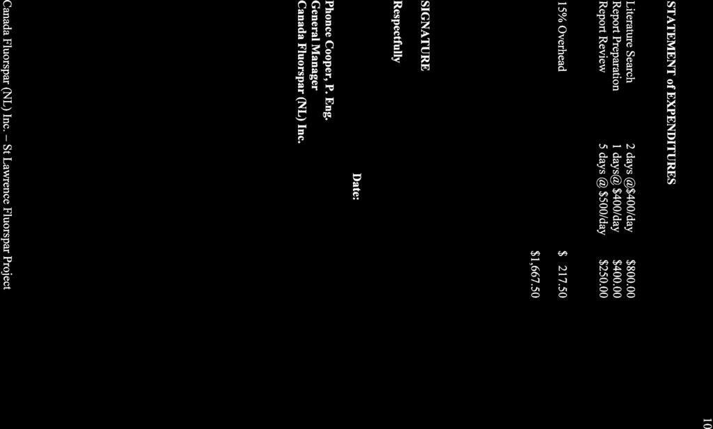
2 1 Canada Fluorspar Inc Assessment Report For Canada Fluorspar (NL) Inc. License M, NTS 1L/14 Newfoundland and Labrador Submitted by; Phonce Cooper, P. Eng. James Reeves, P. Geo. Frank Pitman, CET Norman Wilson, P. Eng. Total Expenditure: $ For: Canada Fluorspar (NL) Inc. January 2012
3 2 Table of Contents Page No. 1.0 Summary and Recommendations Introduction Location Previous Work Physiography Regional Geology Local Geology Work Completed Conclusions and Recommendations 9 Statement of Expenditure References List of Figures Figure 1.0 Location Map of Newfoundland 4 Figure 2.0 Location Map of Property 5 Figure 3.0 Claim Map Showing the Location of the Licence 6 Appendices Appendix 1 List of Personnel
4 3 1.0 Summary and Recommendations Fluorite mineralization in the St Lawrence area has been known since the late 1800 s. Exploration work, undertaken in the early 1900 s, identified over 35 fluorite veins. The St Lawrence Corporation undertook the first mining operations on the Black Duck Vein in Mining operations were developed on a number of the larger veins with the Tarefare, Director and Blue Beach veins providing the largest resource. Mine operations were continued with occasional short periods of mine closures until 1990 when the mines were closed. Burin Minerals began work at developing plans to reopen the mines in the St Lawrence area in the early 1990 s. During the past twenty years work continued toward the develop the resource base of the property through the completion of reports, Pre Feasibility reports and a diamond drill program. The Canada Fluorspar (NL) Inc. property is comprised of three Mine Leases and six Mineral Claim Blocks. This assessment report documents the progress for Mineral Claim Block M during the year Introduction Canada Fluorspar (NL) Inc. holds the Mineral Claim Block Number M in the St Lawrence area of Newfoundland. Exploration and mining of fluorite in the area has been conducted in the area over the past one hundred years. The industrial demand for fluorite is strong and the assessment and development of properties with known fluorite mineralization continue to be an active part of the mining industry. The work that has been conducted on Mineral Block M during the past assessment period consisted of a review of the technical data in preparation for the 2012 field season. 1.2 Location The St Lawrence property is located near the southern tip of the Burin Peninsula, adjacent to the Town of St Lawrence. The town is located 210 kilometers west of St John s, Newfoundland, Canada (See Figure 1.0). Access to the area is via an all weatherpaved road 350 kilometers distance (via the Trans Canada Highway and Route 220) from St John s to the Town of St Lawrence, Newfoundland (See Figure 2.0). No commercial air transportation or rail service is available to the area. The property is bounded by UTM coordinates (NAD 27, Zone 21) 5,193,500N and 5,194,000N and 617,000E and 617,500E (See Figure 3.0).

5 4 Figure 1.0

6 5 Figure 2.0

7 6 Figure Previous Work Fluorite mineralization was known to exist in the St Lawrence area since the late1800 s but active exploration was not undertaken until the early 1900 s. Mineralization, identified near Blue Beach, lead to the discovery of numerous fluorite veins between 1920 and The St Lawrence Corporation undertook the first recorded underground mining operation on the Black Duck Vein in 1933 and continued work on this vein until The American Fluorspar Limited (New Fluor) began operations on the Director and parts of the Tarefare veins in Alcan purchased the mines in 1942 and produced fluorite from the mines until 1978 when operations ceased due to labor unrest and the lower cost foreign supplies. St Lawrence Fluorite Limited (Minworth-UK) acquired the mine property in the early 1980 s and undertook mining operations 1986 to Fluorite was produced was from
8 7 underground operations at Blue Beach and open pit operations in the Tarefare and Director veins. Low fluorite prices resulted in the mine closure in In 1990, the mining property was returned to the Government of Newfoundland and Labrador. Early in 1996, Burin Minerals Limited (BML) applied the Department of Fisheries and Oceans (DFO) for a new tailings facility at Shoal Cove Pond. Approval was received about a year later. Roscoe Postle Associates Inc completed a review of the diamond-drill hole and underground assay database for the Blue Beach North and Tarefare veins in A preliminary resource estimate was completed. Following additional drilling in 1999, the resource estimate was subsequently revised in Physiography The area of the mine property is underlain by glacial till covered by varying thicknesses of peat ranging from a few centimeters to over two metres. Outcrop exposure is scarce inland from the coast. Till thicknesses commonly range from 2 to 4 metres in depth. The topography of the mine area consists of gently rolling hills sloping south to the Atlantic Ocean. Steep cliffs characterize the coast with gravel beaches in the sheltered harbours. Vegetation consists of stunted spruce, alder and scrub brush in sheltered areas with numerous marshes and peat bogs. Drainage is poor with terraced bogs and occasional small brooks draining southward into the ocean. 1.5 Regional Geology The St Lawrence fluorite veins are formed within the Avalonian belt of the Appalachian Mountain system in eastern Newfoundland. The Avalonian belt covers an area of over 200 km in width on land and extends for more 400 km offshore. This sequence is characterized by sections of thick, dominantly sub aerial, volcanic rocks and marine to terrestrial clastic sedimentary rocks of late Precambrian age. Shallow marine sedimentary and minor volcanic rocks of Cambrian age overlie these older lithologies. An angular unconformity lies between the Cambrian rocks and the younger Devonian and Carboniferous sedimentary and volcanic rocks. Several late Precambrian and late Devonian to Carboniferous aged granites intruded the Avalonian belt rocks. These magmas were generated and emplaced in a variety of arc and back arc or analogous continental arc settings along the length of the Avalonian belt between 635 Ma and 550 Ma. The calc-alkaline rocks erupted as subaerial; caldera pyroclastic rocks, flows and domes. The felsic-to-intermediate magmas were the most probable source of the heat and fluids for the large, spatially associated, hydrothermal systems. Folding and thrust faulting of the Cambrian and older sequences preceded the intrusion of the Carboniferous age St Lawrence granite (SLG). The St Lawrence granite intrudes the shales and limestones of the Brigus Formation and the Late Proterozoic volcanics of the Burin Series. Van Alstine (1948) described the
9 8 granite as an alaskite type, derived from a highly differentiated magma that was intruded with very little assimilation of the surrounding country rock. The granite has a typical porphyritic texture with three well-developed joint sets. One set parallels the north-south elongate trend of the granite, a second set is normal to the north-south trend and a third set is horizontal. Quartz porphyry dykes and sills have been observed in the area and appear to have a similar chemical composition and the granite. These dykes and sills are considered to have come from the same source as the granite. The pluton was been radiometrically age dated as 315+/- 10 Ma. This age places the granite in the Lower Pennsylvanian age (Bell and Bleinkensop 1976). Teng (1974) suggests that the granite was emplaced in four separate stages. The first phase introduced the rhyolite sills and dykes to the area. The remaining phases introduced larger volumes of magma with associated volatiles carrying the mineralization and causing the associated alteration. 1.6 Local Geology St Lawrence is hoist to over 40 significant fluorite bearing veins. These veins vary in width from a few centimeters to locally over 30 meters with a strike length ranging up to 3 kilometers. The granite hoist is a porphyritic peralkaline Carboniferous age pluton that has intruded Late Precambrian and Cambrian volcanic and sedimentary rocks. The grain size is characteristic of intrusive rocks and exhibits decreases toward the contact with the older rocks. Within the granite, tufficite, comprised of angular granite fragments in a fine matrix has been observed. Miarolitic structures are present in the granite adjacent to the contacts with the older rocks. Pink quartz-feldspar porphyry dykes are present outside the western margin of the granite intrusion. The fluorite veins in the granite are associated with the jointing and faulting within the batholith. The thicker fluorite veins exhibit features commonly associated with multiple periods of movement and fluid injection. The veins exhibit features that are characteristic of boudinage type structures with a variation in thickness along strike and with depth. The veins contain higher grades pods and varying amounts of mineralized granite breccias along one or both sides of the vein structure. Three major types of fluorite veins have been identified in the area. They are as follows: 1) Low grade veins with an average width of 7m and containing grades varying from 35% to 70% CaF 2. This type includes Tarefare, Director and Blue Beach North and South veins. 2) High grade veins with an average thickness of less than 1m and containing grades averaging 95% CaF 2. This type includes Lord and Lady Gulch, Iron Springs and Canal veins.
10 9 3) The third type includes veins in the peripheral areas and they contain significant amounts of barite with fluorite. This type includes Meadow Woods, Lunch Pond, Clam Pond and Anchor Drogue veins. Van Alstine, 1948, suggested that the mineralized veins in the peripheral areas of the SLG pluton might extend to greater depth than those in the more central areas due to the affects of erosion. 1.7 Work Completed Work completed during the past year consisted of a review of the available technical data with the objective of designing of a field program to be conducted during The mineral block lies to the south of the Grebes Nest Vein and southwest of the Tarefare Vein. The area has potential to contain structures containing fluorite mineralization. The limited rock exposure inland from the coast will require the use of geophysical techniques and diamond drilling to assess the mineral potential of the area. 1.8 Conclusions and Recommendations Assessment of the available technical information suggests that the mineral block may have a potential to contain fluorite vein(s). The limited amount of rock exposure in this area will require the use of geophysical techniques to further evaluate the mineral potential of this block. The determination of a suitable geophysical method, followed by a field trial to determine the effectiveness of the system is recommended. Assuming, the geophysical method produces positive results, a grid(s) should be established over selected area(s) and a survey should be undertaken.

11
12 11 REFERENCES Alcan archives : Potential references from 14 boxes of files, maps, reports, and correspondence, Department of Natural Resources, St. John's. Buller, A.E. :Report on Cera Fluorite Project on Cera-Nalco Lot 4 in the Mount Margaret Area of the St. Lawrence Area, Newfoundland. NF Miner. (1974). Carr, G. F. :Industrial Minerals of Newfoundland; Department of Mines and Technical Surveys, Ottawa, Report No. 855 Pages 51-60, Howse, A., Dean, P., Swinden, S., Kean, B., and Morrisey, F. : Fluorspar Deposits of the St. Lawrence Area, Newfoundland: Geology and Economic Potential. Newfoundland Miner. Development Division, Report 83-09, 23 pages (1983). Mason, R.J. : Diamond Drilling Data from the 1973 Diamond Drilling Program to accompany Cera-Nalco Lot Program, Part 2 in the Mount Margaret Area of the Burin Peninsula, Newfoundland. NF Miner. (1973). Robertson D.S. and Associates Limited. : Hydrogeochemical Reconnaissance On Property Of Newfoundland Fluorspar Limited, St. Lawrence Newfoundland. Internal Report for the Aluminum Company of Canada. (1972). Robertson D.S. and Associates Limited. : Geophysical and Geochemical Survey Mount Margaret Area. Newfoundland Fluorspar Works. Internal Report for the Aluminum Company of Canada Ltd., St. Lawrence, Newfoundland. (1974). Strong, D.F., O'Brien, S.J., Taylor, S.W., Strong, P.G., and Wilton, D.H. : Geology of the Marystown (1M/3) and St. Lawrence (1L/14) Map Areas, Newfoundland. Newfoundland Miner. Development Division. Report 77-8, 81 pages (1978). Teng, H.C. : A Lithogeochemical Study of the St. Lawrence granite, Newfoundland. Unpublished M. Sc. Thesis, Memorial University of Nfld. (1974). Teng, H.C., and Strong, D.F. : Geology and geochemistry of the St. Lawrence peralkaline granite and associated fluorite deposits, south east Newfoundland. Canadian Journal of Earth Sciences, Vol. 113, pages 1374 to 1385 (1976) Tilsley, J.E. : Hydrogeochemical Reconnaissance Survey on Property of the Newfoundland Fluorspar Ltd on The St. Lawrence Area, Newfoundland. Newfoundland Miner. Development Division. (1972b). Tilsley, J.E. : Progress Report, Mount Margaret Pond Area, Newfoundland. NF. Miner, Development Division. (1972c). Tilsley, J.E. : Report on Airborne EM and Magnetic Surveys of the St. Lawrence Claims
13 12 Area, Newfoundland. Newfoundland Miner. Development Division. (1973b). Tilsley, J.E. : Report on Cera-Nalco Fluorspar Exploration program from 1971 to 1974 on Nalco Lot 4 on the Burin Peninsula, Newfoundland. NF. Miner Development Division. (1974). Van Alstine, R.E. : Summary Field Report, St. Lawrence Area, Newfoundland. Newfoundland Miner. Development Division. Internal Report (1939). Van Alstine, R.E. : The Fluorspar Deposits of St. Lawrence, Newfoundland. Economic Geology, Volume 39, No. 2, pages109 to132. (1944). Van Alstine, R.E. : Geology and Mineral Deposits of the St. Lawrence Area, Burin Peninsula, Newfoundland. Nfld. Geol. Survey Bulletin No. 23, 73 pages. (1948).
14 13 Appendix 1 List of Personnel Name Address Days Worked Phonce Cooper St Lawrence, NL 0.5 James Reeves New Glasgow, NS 2.0 Norman Wilson Little St Lawrence, NL 0.5 Frank Pitman Little St Lawrence, NL 0.5
Compilation Report Hawke Hill South. Licence No M NTS 01N/06. Newfoundland and Labrador. Submitted by Gordon E. Cooper and Kevin P.
 Compilation Report 2010 Hawke Hill South Licence No. 017282M NTS 01N/06 Newfoundland and Labrador Submitted by Gordon E. Cooper and Kevin P. Ryan For Kevin P. Ryan (Licence holder) January, 2011 Work Year:
CANADA FLUORSPAR (NL) INC. CLARKE S POND ROAD P.O. BOX 337 ST. LAWRENCE, NFLD., A0E 2V0 TEL: (709) FAX: (709)
 INC. CLARKE S POND ROAD P.O. BOX 337 ST. LAWRENCE, NFLD., A0E 2V0 TEL: (709) FAX: (709)") CANADA FLUORSPAR (NL) INC. CLARKE S POND ROAD P.O. BOX 337 ST. LAWRENCE, NFLD., A0E 2V0 TEL: (709) 873-3331 FAX: (709) 873-3335 FIRST YEAR ASSESSMENT REPORT ON CLAIM LICENCE 018023M (8 Claims) AT ST. LAWRENCE,
CANADA FLUORSPAR (NL) INC. CLARKE S POND ROAD P.O. BOX 337 ST. LAWRENCE, NFLD., A0E 2V0 TEL: (709) 873-3331 FAX: (709) 873-3335 FIRST YEAR ASSESSMENT REPORT ON CLAIM LICENCE 018023M (8 Claims) AT ST. LAWRENCE,
%+ '$# $) %, %*$ " $ $ ' %' !()'-!" %( %"%! " *'+ - % %$! $)! " $)!" !$ ' "! )( ! $ '%& ')- % % "!#( (( ((# $) ' ) ((* & *# ' % %"*# ( !!
 %, %*$ $ $ ' %' !()'-! %( %%! *'+ - % %$! $)! $)! !$ ' ! )( ! $ '%& ')- % % !#( (( ((# $) ' ) ((* & *# ' % %*# ( !!") 001L/14/0218 First Year Assessment Report of Prospecting, Rock and Stream Sediment Sampling On Licence 18880M, NTS 1L/14 Burin Peninsula Newfoundland and Labrador Submitted by: Keith Kelloway Work year:
001L/14/0218 First Year Assessment Report of Prospecting, Rock and Stream Sediment Sampling On Licence 18880M, NTS 1L/14 Burin Peninsula Newfoundland and Labrador Submitted by: Keith Kelloway Work year:
FIRST YEAR ASSESSMENT REPORT PROSPECTING LICENCE 16512M MARYSTOWN AREA, BURIN PENINSULA NTS 1M/3
 FIRST YEAR ASSESSMENT REPORT OF PROSPECTING ON LICENCE 16512M MARYSTOWN AREA, BURIN PENINSULA NTS 1M/3 BY NATHANIEL NOEL MSc. FOR E. MICHELE NOEL MINERAL LICENCES: 16512 M WORK CONDUCTED: MID-SEPTEMBER
%+ '$# $) %, %*$ " $ $ ' %' !()'-!" %( %"%! " *'+ - % %$! $)! " $)!" !$ ' "! )( ! $ '%& ')- % % "!#( (( ((# $) ' ) ((* & *# ' % %"*# ( !!
 %, %*$ $ $ ' %' !()'-! %( %%! *'+ - % %$! $)! $)! !$ ' ! )( ! $ '%& ')- % % !#( (( ((# $) ' ) ((* & *# ' % %*# ( !!") 001N/11/0964 Third Year Assessment Report for Licence 20850M Of Prospecting Activity On the Red Rock Property NTS 1N/11 Brigus, Newfoundland and Labrador Submitted by (License Holder) Jason White Work
001N/11/0964 Third Year Assessment Report for Licence 20850M Of Prospecting Activity On the Red Rock Property NTS 1N/11 Brigus, Newfoundland and Labrador Submitted by (License Holder) Jason White Work
FIFTH YEAR ASSESSMENT REPORT ON LICENCE 15809M. GEOCHEMISTRY and PROSPECTING. on the ENGLISH RIDGE PROPERTY, NTS 1N/06
 FIFTH YEAR ASSESSMENT REPORT ON LICENCE 15809M of GEOCHEMISTRY and PROSPECTING on the ENGLISH RIDGE PROPERTY, NTS 1N/06 MARYSVALE, CONCEPTION BAY, NEWFOUNDLAND Submitted by (License Holder) JASON WHITE
Keels Venure Inc. Re: Assessment Report for 6735M, 8289M & 10280M Grouped to M
 Keels Venure Inc. April 10, 2011 Mr. Jim Hinchey, P. Geo. Department of Natural Resources P.O. Box 8700 St. John s, NL A1B 4J6 Re: Assessment Report for 6735M, 8289M & 10280M Grouped to 011690M Dear Jim,
First Year Assessment Report: Report on Prospecting, Rock and Soil Sampling Carried Out From September/2012 to December/2012.
 First Year Assessment Report: Report on Prospecting, Rock and Soil Sampling Carried Out From September/2012 to December/2012 on the Clarkes Pond Property Licence 020334M Northwest Gander River,Central
SECOND and THIRD YEAR ASSESSMENT REPORT PROSPECTING LICENCE M, ROCK CUT PROPERTY, NTS 1N/12, NEWFOUNDLAND. ROY FRENCH (licence holder )
") SECOND and THIRD YEAR ASSESSMENT REPORT Of PROSPECTING On LICENCE 013704M, ROCK CUT PROPERTY, NTS 1N/12, NEWFOUNDLAND. By ROY FRENCH (licence holder ) Work Conducted: Sept. 17, 2008 Nov. 03, 2009 Total
SECOND and THIRD YEAR ASSESSMENT REPORT Of PROSPECTING On LICENCE 013704M, ROCK CUT PROPERTY, NTS 1N/12, NEWFOUNDLAND. By ROY FRENCH (licence holder ) Work Conducted: Sept. 17, 2008 Nov. 03, 2009 Total
%+ '$# $) %, %*$ " $ $ ' %' !()'-!" %( %"%! " *'+ - % %$! $)! " $)!" !$ ' "! )( ! $ '%& ')- % % "!#( (( ((# $) ' ) ((* & *# ' % %"*# ( !!
 %, %*$ $ $ ' %' !()'-! %( %%! *'+ - % %$! $)! $)! !$ ' ! )( ! $ '%& ')- % % !#( (( ((# $) ' ) ((* & *# ' % %*# ( !!") 001L/14/0215 Seventh Year Assessment Report on Prospecting, Rock, Stream and Soil Sampling, and Radiometric Surveying Licence 10689M, NTS 1L14 Burin Peninsula, Newfoundland Submitted by: Keith Kelloway
001L/14/0215 Seventh Year Assessment Report on Prospecting, Rock, Stream and Soil Sampling, and Radiometric Surveying Licence 10689M, NTS 1L14 Burin Peninsula, Newfoundland Submitted by: Keith Kelloway
Summary of Rover Metals Geologic Mapping Program at the Up Town Gold Project, Northwest Territories
 October 13, 2017 Summary of Rover Metals Geologic Mapping Program at the Up Town Gold Project, Northwest Territories Vancouver, British Columbia, Canada - Rover Metals Corp., Rover, is pleased to provide
%+ '$# $) %, %*$ " $ $ ' %' !()'-!" %( %"%! " *'+ - % %$! $)! " $)!" !$ ' "! )( ! $ '%& ')- % % "!#( (( ((# $) ' ) ((* & *# ' % %"*# ( !!
 %, %*$ $ $ ' %' !()'-! %( %%! *'+ - % %$! $)! $)! !$ ' ! )( ! $ '%& ')- % % !#( (( ((# $) ' ) ((* & *# ' % %*# ( !!") 001L/14/0220 Fifth Year Assessment Report of Compilation on Licence 13093M Chambers Cove Property St. Lawrence, Newfoundland and Labrador NTS 1L/14 Work Conducted: February to June 2012 Total Expenditures:
001L/14/0220 Fifth Year Assessment Report of Compilation on Licence 13093M Chambers Cove Property St. Lawrence, Newfoundland and Labrador NTS 1L/14 Work Conducted: February to June 2012 Total Expenditures:
Prospecting Report 'S Office i DB Property, B.C. -J Negro Creek Nelson Mining District NTS 82F.050. Operator: Kootenay Gold Inc.
 . '.' I"' i9 12 Prospecting Report 'S Office i DB Property, B.C. -J Negro Creek Nelson Mining District NTS 82F.050 Operator: Kootenay Gold Inc. Owner: Darlene Lavoie Work Performed Summer of 2007 Report
ASSESSMENT REPORT. HL1 Project, License 06172M (1st year), Newfoundland NTS 2D/05: Report on Prospecting and Rock Sampling For Larry Quinlan
, Newfoundland NTS 2D/05: Report on Prospecting and Rock Sampling For Larry Quinlan") ASSESSMENT REPORT HL1 Project, License 06172M (1st year), Newfoundland NTS 2D/05: Report on Prospecting and Rock Sampling For Larry Quinlan Work conducted from June, 2009 to April, 2010 Total Expenditures:
ASSESSMENT REPORT HL1 Project, License 06172M (1st year), Newfoundland NTS 2D/05: Report on Prospecting and Rock Sampling For Larry Quinlan Work conducted from June, 2009 to April, 2010 Total Expenditures:
First Year Assessment Report on Licence 18084m & 18066m. Prospecting. on the. Crows Gulch Property, NTS 1N/06
 First Year Assessment Report on Licence 18084m & 18066m of Prospecting on the Crows Gulch Property, NTS 1N/06 Marysvale, Conception Bay, Newfoundland and Labrador Submitted by Jason D. White (License Holder)
%+ '$# $) %, %*$ " $ $ ' %' !()'-!" %( %"%! " *'+ - % %$! $)! " $)!" !$ ' "! )( ! $ '%& ')- % % "!#( (( ((# $) ' ) ((* & *# ' % %"*# ( !!
 %, %*$ $ $ ' %' !()'-! %( %%! *'+ - % %$! $)! $)! !$ ' ! )( ! $ '%& ')- % % !#( (( ((# $) ' ) ((* & *# ' % %*# ( !!") 002E/13/1893 THIRD YEAR ASSESSMENT REPORT OF PROSPECTING ON LICENCE 19122M and 19124M Betts Cove, NL NTS 2E/13 BY NATHANIEL NOEL MSc. FOR E. MICHELE NOEL MINERAL LICENCE: 19122M 19124M WORK CONDUCTED:
002E/13/1893 THIRD YEAR ASSESSMENT REPORT OF PROSPECTING ON LICENCE 19122M and 19124M Betts Cove, NL NTS 2E/13 BY NATHANIEL NOEL MSc. FOR E. MICHELE NOEL MINERAL LICENCE: 19122M 19124M WORK CONDUCTED:
Update on the Big Easy Gold Project, Newfoundland
 Update on the Big Easy Gold Project, Newfoundland FORWARD-LOOKING STATEMENTS Certain information contained herein regarding Cartier Iron Corporation, including management s assessment of future plans and
GEOLOGICAL MAPPING OF SKARNS ON THE SHEEP AND EWE CLAIMS, TURNAGAIN RIVER, B.C. DURING THE 1979 SUMMER SEASON
 GEOLOGICAL MAPPING OF SKARNS ON THE SHEEP AND EWE CLAIMS, TURNAGAIN RIVER, B.C. DURING THE 1979 SUMMER SEASON CLAIMS: Sheep 1 to 4 Ewe 1, 3, 4 to 8 Lamb 12 Fraction Liard Mining Division, B.C. NTS 104
RECONNAISSANCE AND SOIL GEOCHEMICAL SAMPLING REPORT PORCUPINE MINING DIVISION ON CLAIM , LANGMUIR TOWNSHIP
 RECONNAISSANCE AND SOIL GEOCHEMICAL SAMPLING REPORT ON CLAIM 1224499, LANGMUIR TOWNSHIP PORCUPINE MINING DIVISION CLM 1224499 NTS: 42A/06 Author: William Randall, P.Geo 1 Table of Contents Work Performed
ASX ANNOUNCEMENT Date: 03 October 2018 Number: 604/031018
 ASX ANNOUNCEMENT Date: 03 October 2018 Number: 604/031018 TRIAL BULK SAMPLING PROGRAMME COMPLETED AT BLACKRIDGE CONGLOMERATE-HOSTED GOLD PROJECT QUEENSLAND Approx 8.5 tonnes of samples collected covering
PRELIMINARY INVESTIGATIONS OF THE FLUORITE MINERALIZATION IN THE SEDIMENT- AND RHYOLITE-HOSTED AGS VEIN SYSTEM, ST. LAWRENCE, NEWFOUNDLAND
 Current Research (2018) Newfoundland and Labrador Department of Natural Resources Geological Survey, Report 18-1, pages 95-121 PRELIMINARY INVESTIGATIONS OF THE FLUORITE MINERALIZATION IN THE SEDIMENT-
FIRST YEAR ASSESSMENT REPORT ON THE HAMMERDOWN SOUTH PROPERTY KING S POINT AREA, NEWFOUNDLAND
 FIRST YEAR ASSESSMENT REPORT ON THE HAMMERDOWN SOUTH PROPERTY KING S POINT AREA, NEWFOUNDLAND Licenses: 017558M, 017559M, 017560M and 017561M NTS Mapsheets: 012H/08 and 012H/09 Garry Fraser 66a Frontenac
CARIBOO - GRIZZLY ZINC PROJECT
 CARIBOO - GRIZZLY ZINC PROJECT The Grizzly Lake or Cariboo Zinc property straddles the gravel Weldwood 8400 logging road in the Grizzly Lake area about 55 kilometres northeast of Likely. Roads constructed
State Metallic Minerals Lease Sale Minnesota s Vermilion Gold District
 State Metallic Minerals Lease Sale Minnesota s Vermilion Gold District State Metallic Minerals Lease Sale Notice of Intent Scale 1:100,000 State Metallic Minerals Lease Sale This portion of the lease sale
Toronto, Canada March 4, 2013
 NEWS RELEASE SAS REPORTS ADDITIONAL DRILLING RESULTS FOR THE HISLOP NORTH AND SMOKE DEEP ZONES AND SIGNIFICANT INITIAL RESULTS FROM THE HISLOP PIT COMPLEX AND NEW SEDIMENT ZONE AT THE HOLLOWAY MINE Hislop
3. GEOLOGY. 3.1 Introduction. 3.2 Results and Discussion Regional Geology Surficial Geology Mine Study Area
 3. GEOLOGY 3.1 Introduction This chapter discusses the baseline study of the geology and mineralization characteristics of the mine study area. The study consolidates existing geological data and exploration
GEOLOGIC MAPS PART II
 EARTH AND ENVIRONMENT THROUGH TIME LABORATORY - EES 1005 LABORATORY FIVE GEOLOGIC MAPS PART II Introduction Geologic maps of orogenic belts are much more complex than maps of the stable interior. Just
Introducti on. Land Survey. Geomagnetic Survey. Geomagnetic Results and Interpretati ons - Conclusions and Recommendations C
 m M 42A86SW8281 63.42 PRICE 010 C O H T E H l 42A86SW828I 63.42 PRICE 010C Introducti on Land Survey Geomagnetic Survey Geomagnetic Results and Interpretati ons - Conclusions and Recommendations - - -
OYUT ULAAN COPPER GOLD PROJECT RECONNAISSANCE DRILLING RESULTS
 ASX / MEDIA RELEASE Manager Company Announcements By Electronic Lodgement 7 pages Company Announcements Office 6 June 2013 Australian Securities Exchange 4th Floor, 20 Bridge Street SYDNEY NSW 2001 OYUT
1 FILMED 1. FILE NO:!..rsrru -* -. GRAND TWO CLAIM
 FILE NO:!..rsrru -* -. GRAND TWO CLAIM REPORT ON 1993 ASSESSMENT WORK GRAND TWO CLAIM REC. NO. 301849 NELSON MINING DIVISION NTS MAP SHEET 82F6/W 49 25'51" NORTH 117 18'08" WEST 1 FILMED 1 AUTHOR: R. Jordan,
News Release No GOLD AND COPPER MINERALIZATION DISCOVERED DURING PHASE 2 EXPLORATION AT THE MCBRIDE PROPERTY
 November 19, 2018 TSX Venture Exchange Listed Frankfurt Exchange Listed News Release No. 303-2018 GOLD AND COPPER MINERALIZATION DISCOVERED DURING PHASE 2 EXPLORATION AT THE MCBRIDE PROPERTY Vancouver,
2013 GEOLOGICAL ASSESSMENT REPORT SHERIDAN HILL PROPERTY
 2013 GEOLOGICAL ASSESSMENT REPORT ON THE SHERIDAN HILL PROPERTY NEW WESTMINSTER MINING DIVISION BRITISH COLUMBIA NTS 092G07 49 16 31 NORTH LATITUDE, 122 39 48 WEST LONGITUDE PREPARED FOR Sheridan Hill
Hiking the Bold Coast, Cutler, Maine
 Maine Geologic Facts and Localities June, 2010 Hiking the Bold Coast, Cutler, Maine 44 o 39 36.34 N, 67 o 12 46.99 W Text by Robert A. Johnston, Department of Agriculture, Conservation & Forestry 1 Map
As compaction and cementation of these sediments eventually occur, which area will become siltstone? A) A B) B C) C D) D
 A B) B C) C D) D") 1. A student obtains a cup of quartz sand from a beach. A saltwater solution is poured into the sand and allowed to evaporate. The mineral residue from the saltwater solution cements the sand grains together,
1. A student obtains a cup of quartz sand from a beach. A saltwater solution is poured into the sand and allowed to evaporate. The mineral residue from the saltwater solution cements the sand grains together,
Mishi Lake Gold Property Mishibishu Lake Area, Wawa
 Mishi Lake Gold Property Mishibishu Lake Area, Wawa Location, Accessibility, Infrastructure and Local Resources The property is located 40 km west of Wawa, Ontario, in the Mishibishu Lake Area, Sault Ste.
IVANHOE MINES LTD ACQUIRES FOUR NEW COPPER-GOLD PROJECTS IN MONGOLIA
 News Release October 15, 2001 IVANHOE MINES LTD ACQUIRES FOUR NEW COPPER-GOLD PROJECTS IN MONGOLIA SINGAPORE - Ivanhoe Mines Chairman Robert Friedland and Senior Vice-President, Exploration, Douglas Kirwin
Practice Test Rocks and Minerals. Name. Page 1
 Name Practice Test Rocks and Minerals 1. Which rock would be the best source of the mineral garnet? A) basalt B) limestone C) schist D) slate 2. Which mineral is mined for its iron content? A) hematite
POTENTIAL OF THE DONGWE COPPER GOLD PROJECT
 POTENTIAL OF THE DONGWE COPPER GOLD PROJECT By Nathan Sabao, P.Geo. September 2015 1 TABLE OF CONTENTS Page 1.0 EXECUTIVE SUMMARY 1 2.0 LOCATION 2 3.0 ACCESS 2 4.0 GEOLOGY 3 5.0 PREVIOUS DRILLING 5 6.0
Total Magnetic Field and VLF Surveys on the Swayze Property. Claim Swayze Township. Porcupine Mining Division
 1 January, 016 NTS: 041 O 15 Total Magnetic Field and VLF Surveys on the Swayze Property Claim 475471 Swayze Township Porcupine Mining Division 380850E, 599450N UTM Z17N NAD83 Report Prepared for: 540
For personal use only
 ASX ANNOUNCEMENT ASX: IVG Date: 30 April 2012 Number: 030_300412 MARCH 2012 QUARTERLY REPORT SUMMARY Market Cap A$2.23m ($0.062 p/s) Issued Capital 36,006,006 Assay data and mineral alteration studies
HOWE COPPER MINE PROJECT HIGH GRADE Cu-Ag with Au
 HOWE COPPER MINE PROJECT HIGH GRADE Cu-Ag with Au The Howe Copper Mine property is located approximately 55 kilometres northwest of Vancouver, BC. It is situated at 1431 metres elevation on the eastern
Reconnaissance. Of the. Denis mineral claims. Situated at Kilometer 844 of the Alaska Highway. Liard Mining Division. Northeastern British Columbia
 Reconnaissance Of the Denis mineral claims Situated at Kilometer 844 of the Alaska Highway Liard Mining Division Northeastern British Columbia N.T.S. 94M.075 Latitude 59 42 25 Longitude 127 13 12 Field
Advancing High Grade Gold Assets in Red Lake, Ontario
 Advancing High Grade Gold Assets in Red Lake, Ontario Forward Looking Statement Except for historical information contained herein, this presentation may contain forward-looking statements including but
%+ '$# $) %, %*$ " $ $ ' %' !()'-!" %( %"%! " *'+ - % %$! $)! " $)!" !$ ' "! )( ! $ '%& ')- % % "!#( (( ((# $) ' ) ((* & *# ' % %"*# ( !!
 %, %*$ $ $ ' %' !()'-! %( %%! *'+ - % %$! $)! $)! !$ ' ! )( ! $ '%& ')- % % !#( (( ((# $) ' ) ((* & *# ' % %*# ( !!") 001M/09/0796 SEVENTH YEAR ASSESSMENT REPORT ON LIC. 13640M FIRST YEAR ASSESSMENT REPORT ON LIC. 18523M FIRST YEAR ASSESSMENT REPORT ON LIC. 18524M OF PROSPECTING ON TOWER WEST AREA, BURIN PENINSULA NTS
001M/09/0796 SEVENTH YEAR ASSESSMENT REPORT ON LIC. 13640M FIRST YEAR ASSESSMENT REPORT ON LIC. 18523M FIRST YEAR ASSESSMENT REPORT ON LIC. 18524M OF PROSPECTING ON TOWER WEST AREA, BURIN PENINSULA NTS
The Geology of Sebago Lake State Park
 Maine Geologic Facts and Localities September, 2002 43 55 17.46 N, 70 34 13.07 W Text by Robert Johnston, Department of Agriculture, Conservation & Forestry 1 Map by Robert Johnston Introduction Sebago
Uncovering The Riches of the Abitibi Greenstone Belt of Canada
 1 TSX.V: ALZ June 2016 Uncovering The Riches of the Abitibi Greenstone Belt of Canada The Haultain Gold Discovery The Abitibi Greenstone Belt & Gold 170+ million oz of gold produced to date from more than
The 3 types of rocks:
 Igneous Rocks and Intrusive Igneous Activity The 3 types of rocks:! Sedimentary! Igneous! Metamorphic Marble 1 10/7/15 SEDIMENTARY ROCKS Come from rocks sediments (rock fragments, sand, silt, etc.) Fossils
TIGER GOLD EXPLORATION CORPORATION. Prospecting Over the HARKER HERITAGE PROPERTY AREA 10. Harker Township, Ontario
 PO Box 219, 14579 Government Road, Larder Lake, Ontario, P0K 1L0, Canada Phone (705) 643-2345 Fax (705) 643-2191 www.cxsltd.com TIGER GOLD EXPLORATION CORPORATION Prospecting Over the HARKER HERITAGE PROPERTY
%+ '$# $) %, %*$ " $ $ ' %' !()'-!" %( %"%! " *'+ - % %$! $)! " $)!" !$ ' "! )( ! $ '%& ')- % % "!#( (( ((# $) ' ) ((* & *# ' % %"*# ( !!
 %, %*$ $ $ ' %' !()'-! %( %%! *'+ - % %$! $)! $)! !$ ' ! )( ! $ '%& ')- % % !#( (( ((# $) ' ) ((* & *# ' % %*# ( !!") 001M/16/0790 TENTH YEAR ASSESSMENT REPORT OF PROSPECTING ON LICENCE 18624M HICKEYS POND AREA, BURIN PENINSULA NTS 1M/16 BY NATHANIEL NOEL MSc. FOR E. MICHELE NOEL MINERAL LICENCES: 18624 M WORK CONDUCTED:
001M/16/0790 TENTH YEAR ASSESSMENT REPORT OF PROSPECTING ON LICENCE 18624M HICKEYS POND AREA, BURIN PENINSULA NTS 1M/16 BY NATHANIEL NOEL MSc. FOR E. MICHELE NOEL MINERAL LICENCES: 18624 M WORK CONDUCTED:
Drill locations for the 2015 program are highlighted in the geology map below.
 2015 Exploration Program The exploration program plan at KSM for 2015 was designed to improve the understanding of block cave targets and support engineering/environmental aspects of development scenarios.
L.O: HOW GEOLOGISTS SEQUENCE EVENTS IN EARTH'S GEOLOGIC HISTORY IF NOT OVERTURNED, OLDEST ON BOTTOM, YOUNGEST ON TOP
 L.O: HOW GEOLOGISTS SEQUENCE EVENTS IN EARTH'S GEOLOGIC HISTORY IF NOT OVERTURNED, OLDEST ON BOTTOM, YOUNGEST ON TOP 1. Unless a series of sedimentary rock layers has been overturned, the bottom rock layer
DÉCOUVERTE Positioned for Discovery in James Bay, Quebec. Investor Presentation, January 2018 by Danae Voormeij, MSc, PGeo
 DÉCOUVERTE Positioned for Discovery in James Bay, Quebec Investor Presentation, January 2018 by Danae Voormeij, MSc, PGeo Location Maps and Infrastructure Location: Durango Resources 100% owned Découverte
H/16/2065
 2015-02-06 2012-02-21 012H/16/2065 TENTH YEAR ASSESSMENT REPORT OF SITE VISIT AND POLISHING TESTS ON LIC. # 19491m BAIE VERTE PENINSULA, NL NTS 12H/16 BY NATHANIEL NOEL MSc. FOR E. MICHELE NOEL MINERAL
Magmatism in Western Cascades Arc. Early Tertiary Magmatism Part II. Washington Magmatism. Western Oregon. Southern Oregon
 Early Tertiary Magmatism Part II Reference: DNAG v. 3, Ch. 7, pp 294-314 Magmatism in Western Cascades Arc Active from 38 to 17 Ma New volcanic activity west of Clarno Fm and south into Oregon Western
IVANHOE DISCOVERS IMPORTANT NEW GOLD-COPPER PORPHYRY DISTRICT IN SOUTHERN MONGOLIA NEW PORPHYRY DISTRICT NOW NAMED BRONZE FOX
 November 29, 2004 IVANHOE DISCOVERS IMPORTANT NEW GOLD-COPPER PORPHYRY DISTRICT IN SOUTHERN MONGOLIA NEW PORPHYRY DISTRICT NOW NAMED BRONZE FOX ULAANBAATAR, MONGOLIA Ivanhoe Mines Chairman Robert Friedland
ARGENTINE FRONTIER RESOURCES INC (AFRI) SALTA EXPLORACIONES SA (SESA)
 SALTA EXPLORACIONES SA (SESA)") ARGENTINE FRONTIER RESOURCES INC (AFRI) SALTA EXPLORACIONES SA (SESA) LA SARITA IOCG-Porphyry Copper-Gold August 2006 La Sarita Cateo 2 La Sarita - bleached center is Taca Taca Arriba. The hematite zone
ARGENTINE FRONTIER RESOURCES INC (AFRI) SALTA EXPLORACIONES SA (SESA) LA SARITA IOCG-Porphyry Copper-Gold August 2006 La Sarita Cateo 2 La Sarita - bleached center is Taca Taca Arriba. The hematite zone
SUMMARY REPORT. RE-ESTABLISH CLAIM BOUNDARY (Claim ) CARR TOWNSHIP (Larder Lake Mining Division) NTS (42 Al09) FOR
 CARR TOWNSHIP (Larder Lake Mining Division) NTS (42 Al09) FOR") 2.44330 " SUMMARY REPORT RE-ESTABLISH CLAIM BOUNDARY (Claim 3002288) CARR TOWNSHIP (Larder Lake Mining Division) NTS (42 Al09) FOR ST ANDREW GOLDFIELDS LTD. ""'1,.I Les 1. Kovacs, P. Geo For: St Andrew
2.44330 " SUMMARY REPORT RE-ESTABLISH CLAIM BOUNDARY (Claim 3002288) CARR TOWNSHIP (Larder Lake Mining Division) NTS (42 Al09) FOR ST ANDREW GOLDFIELDS LTD. ""'1,.I Les 1. Kovacs, P. Geo For: St Andrew
ASSESSMENT REPORT ON THE PEAVINE PROJECT. DGW & Associates # Alberni Street, Vancouver, British Columbia, V6E 4V2
 ASSESSMENT REPORT ON THE PEAVINE PROJECT KAMLOOPS MINING DIVISION BRITISH COLUMBIA NTS 082M 12 Latitude 51 36' 19.0"North -- Longitude --119 47' 27.0"West UTM Zone 11, NAD 83 5720827N 306744E Prepared
The McPhillamys Gold Deposit, Discovery History & Geology. Presenter: Tara French
 The McPhillamys Gold Deposit, Discovery History & Geology. Presenter: Tara French Forward-Looking Statements This presentation contains forward-looking statements. without limitation: Estimates of future
TOPOGRAPHICAL SURVEY REPORT ON THE GREENDROP PROPERTY NEAR CHILLIWACK, B.C. 92-H-3/W
 TOPOGRAPHICAL SURVEY REPORT ON THE GREENDROP PROPERTY NEW WESTMINSTER M.D. NEAR CHILLIWACK, B.C. 92-H-3/W Location: The central pap of the claims is located at coordinates 49 08'N, latitude by 121 26'W,
ANTLER GOLD EXPLORATION UPDATE, WILDING LAKE GOLD PROJECT, NEWFOUNDLAND
 ANTLER GOLD EXPLORATION UPDATE, WILDING LAKE GOLD PROJECT, NEWFOUNDLAND HALIFAX, NOVA SCOTIA (CNW May 10, 2018) Antler Gold Inc. ( Antler ) (TSX-V:ANTL) is pleased to provide an update on its upcoming
VICTORIA COPPER MINE
 THE VICTORIA COPPER MINE Elko County, Nevada USA Chuck Berg 801.947.8308 chuck.berg@coldwellutah.com CONTENTS SUMMARY... 1 LOCATION AND PROPERTY DESCRIPTION... 1 HISTORY... 3 PRODUCTION AND RESERVES...
A Geological Tour of Tumbledown Mountain, Maine
 Maine Geologic Facts and Localities April, 1998 A Geological Tour of Tumbledown Mountain, Maine 44 45 3.21 N, 70 32 50.24 W Text by Robert G. Marvinney, Department of Agriculture, Conservation & Forestry
Chapter 4 8/27/2013. Igneous Rocks. and Intrusive Igneous Activity. Introduction. The Properties and Behavior of Magma and Lava
 Introduction Chapter 4 Igneous rocks form by the cooling of magma (or lava). Large parts of the continents and all the oceanic crust are composed of. and Intrusive Igneous Activity The Properties and Behavior
%+ '$# $) %, %*$ " $ $ ' %' !()'-!" %( %"%! " *'+ - % %$! $)! " $)!" !$ ' "! )( ! $ '%& ')- % % "!#( (( ((# $) ' ) ((* & *# ' % %"*# ( !!
 %, %*$ $ $ ' %' !()'-! %( %%! *'+ - % %$! $)! $)! !$ ' ! )( ! $ '%& ')- % % !#( (( ((# $) ' ) ((* & *# ' % %*# ( !!") 001M/10/0783 Compilation Report Harbour Mille Property Licence No. 018813M NTS 01M/10 Newfoundland and Labrador Submitted by Kevin P. Ryan For Kevin P. Ryan (Licence holder) 2011-12 Work Year: 1 Total
001M/10/0783 Compilation Report Harbour Mille Property Licence No. 018813M NTS 01M/10 Newfoundland and Labrador Submitted by Kevin P. Ryan For Kevin P. Ryan (Licence holder) 2011-12 Work Year: 1 Total
Quarterly Report for the period ended 31 March 2006
 96 Parry Street PERTH WA 6000 PO Box 8178 PERTH BUSINESS CENTRE WA 6849 Ph: (08) 9328 9292 Fax: (08) 9227 6011 Email: info@nsrltd.com, Web: www.nsrltd.com Quarterly Report for the period ended 31 March
The Geology of Two Lights State Park. Cape Elizabeth, Maine
 Maine Geologic Facts and Localities June, 2002 Cape Elizabeth, Maine 43 33 33.48 N, 70 12 13.32 W Text by Henry N. Berry IV and Robert G. Marvinney, Department of Agriculture, Conservation & Forestry 1
Essentials of Geology, 11e
 Essentials of Geology, 11e Igneous Rocks and Intrusive Activity Chapter 3 Instructor Jennifer Barson Spokane Falls Community College Geology 101 Stanley Hatfield Southwestern Illinois College Characteristics
For personal use only
 2 May 2018 METEORIC SECURES FURTHER HIGHLY PROSPECTIVE CANADIAN COBALT PROJECT Meteoric has secured the Beauchamp Cobalt Project 40km north of the Cobalt Camp, Ontario Beauchamp comprises 33.5km 2 being
Mountain Maid Gold System Displays Major Size Potential
 29 July 2008 The Manager, Companies Australian Securities Exchange Ltd Electronic Announcement System Dear Sir, AXIOM MINING LIMITED (ASX CODE: AVQ) ASX Announcement Mountain Maid Gold System Displays
entire 1.5 meter drift width
 GOLD HILL SUMMARY In 1864 gold fever struck in the south Kootenays east of Cranbrook, British Columbia as placer gold was discovered in the Wild Horse River. What followed was everything one can imagine
Copperstone Technical Report Update on 2018 Drilling Campaign
 2018 Copperstone Technical Report Update on 2018 Drilling Campaign Chris McKnight Copperstone Resources AB 5/16/2018 Highlights Mineralisation consisting of interspersed chalcopyrite veins (assay results
Anthill Resources Yukon - An Update on the Einarson Project
 Anthill Resources Yukon - An Update on the Einarson Project The Eastern Extension of a Carlin-type Gold Trend in the Selwyn Basin Anthill Resources Ltd Yukon Claim Holdings Over 2400 km 2 Property Location
B) color B) Sediment must be compacted and cemented before it can change to sedimentary rock. D) igneous, metamorphic, and sedimentary rocks
 color B) Sediment must be compacted and cemented before it can change to sedimentary rock. D) igneous, metamorphic, and sedimentary rocks") 1. Which characteristic of nonsedimentary rocks would provide the least evidence about the environment in which the rocks were formed? A) structure B) color C) crystal size D) mineral composition 2. Which
1. Which characteristic of nonsedimentary rocks would provide the least evidence about the environment in which the rocks were formed? A) structure B) color C) crystal size D) mineral composition 2. Which
for the Greenwood Mining Division, B.C. NTS 82E/7W 29' W, Longitude 118' 53' N Prepared by D. Dylan Watt, B.Sc.
 for the FltE NO: u VOLT 1, VOLT 2, VOLT 3, & VOLT 4 CLAIMS Greenwood Mining Division, B.C. NTS 82E/7W Latitude 49' 29' W, Longitude 118' 53' N Prepared by D. Dylan Watt, B.Sc. #309-1996 Trutch Street Vancouver,
Geological & Geophysical Interpretation of ZTEM EM and Magnetic Survey. Kemess Project, BC. for AuRico Metals Inc. September, 2016 Nicole Pendrigh
 Geological & Geophysical Interpretation of ZTEM EM and Magnetic Survey Kemess Project, BC for AuRico Metals Inc. September, 2016 Nicole Pendrigh SUMMARY REPORT Regional setting Located in North central
LOS AZULES April 2018
 April 2018 lies along the southern extensions of the highly productive Paleocene Mineral Belt in northern Chile that contains numerous important copper, gold and silver mines and projects, and to the south
National Instrument Technical Report
 National Instrument 43-101Technical Report Pigeon River Property Hartington Township Ontario, Canada Thunder Bay Mining Division, NTS 42A4 Geology Updated Technical Report UTM: Zone 16, 277134m E, 5332229m
Chapter 4 Rocks & Igneous Rocks
 Chapter 4 Rocks & Igneous Rocks Rock Definition A naturally occurring consolidated mixture of one or more minerals e.g, marble, granite, sandstone, limestone Rock Definition Must naturally occur in nature,
SQUARE POST PROJECT CHARTERS TOWERS NORTH QUEENSLAND AUSTRALIA
 SQUARE POST PROJECT CHARTERS TOWERS NORTH QUEENSLAND AUSTRALIA Square Post - Summary PROJECT DETAILS - SQUARE POST The Square Post exploration permit (EPM 18510) contains two styles of mineralisation:
Press Release Azimut and Partners announce Drilling Results from Eleonore South Gold Property, James Bay region, Quebec
 For immediate release December 17, 2018 Symbol: AZM. TSX Venture Press Release Azimut and Partners announce Drilling Results from Eleonore South Gold Property, James Bay region, Quebec Longueuil, Quebec
RESULTS OF OPERATIONS Semi Annual Exploration Report BANLUNG EXPLORATION LICENSE, CAMBODIA FOR THE PERIOD 2015:06:30 TO 2015:12:31
 RESULTS OF OPERATIONS BANLUNG EXPLORATION LICENSE, CAMBODIA FOR THE PERIOD 2015:06:30 TO 2015:12:31 Introduction Work over the period has included the completion of a detailed induced polarization geophysical
Structural Geology Lab. The Objectives are to gain experience
 Geology 2 Structural Geology Lab The Objectives are to gain experience 1. Drawing cross sections from information given on geologic maps. 2. Recognizing folds and naming their parts on stereoscopic air
BONANZA-GRADE GOLD FROM NEOPROTEROZOIC LOW- SULPHIDATION EPITHERMAL VEINS AND BRECCIAS, BERGS PROSPECT, AVALON ZONE, EASTERN NEWFOUNDLAND
 GOVERNMENT OF NEWFOUNDLAND AND LABRADOR Department of Mines and Energy Geological Survey BONANZA-GRADE GOLD FROM NEOPROTEROZOIC LOW- SULPHIDATION EPITHERMAL VEINS AND BRECCIAS, BERGS PROSPECT, AVALON ZONE,
CHAMPION BEAR RESOURCES
 CHAMPION BEAR RESOURCES EXPLORING ADVANCED STAGE PRECIOUS METAL PROPERTIES IN ONTARIO Exploration Update January 2011 Forward Looking Statements This exploration update contains forward looking statements
Spruce Ridge Resources Ltd Leslie Road West, Puslinch, ON N0B 2J0 Telephone: (519) , Fax: (519)
 , Fax: (519)") Spruce Ridge Resources Ltd. 7735 Leslie Road West, Puslinch, ON N0B 2J0 Telephone: (519) 822-5904, Fax: (519) 823-5090 PRESS RELEASE 2018-07 July 24, 2018 Spruce Ridge Resources Provides Update on the
Spruce Ridge Resources Ltd. 7735 Leslie Road West, Puslinch, ON N0B 2J0 Telephone: (519) 822-5904, Fax: (519) 823-5090 PRESS RELEASE 2018-07 July 24, 2018 Spruce Ridge Resources Provides Update on the
EXISTING GEOLOGICAL INFORMATION
 CHAPER 3 EXISTING GEOLOGICAL INFORMATION 3-1 General Geology of the Surrounding Area (1) General geology and ore deposits in Mongolia Geographically, Mongolia is a country located between Russia to the
CONTENTS. Location, Access and History...6. Tenure Status and Geology Regional Andy Property Geology Map...9
 TYPE OFWORK IN THIS REPORT EXTENT OF WORK (rn METRTC UNITS) ON WHICH CLAIMS PROJECT COSTS APPORTIONED (incl. support) GEOLOGICAL (scale, area) Ground, mapping Photo interpretation GEOPHYSICAL (line-kilometres)
GEOLOGICAL MAPPING REPORT ON THE ASH MINERAL CLAIM OSOYOOS MINING DIVISION ASHNOLA RIVER MAP SHEET NTS M092,H019 MCBRIDE CREEK AREA, ASHNOLA RIVER,
 GEOLOGICAL MAPPING REPORT ON THE ASH MINERAL CLAIM OSOYOOS MINING DIVISION ASHNOLA RIVER MAP SHEET NTS M092,H019 LATITUDE 49 o O6, LONGITUDE 120 o 22 MCBRIDE CREEK AREA, ASHNOLA RIVER, KEREMEOS, B.C. CANADA
Introduction. Report of Activities T. G. MacHattie
 Report of Activities 2009 65 Magmatism, Alteration and Polymetallic Mineralization in Late Devonian to Early Carboniferous Felsic Volcanic and Plutonic Rocks of the Eastern Cobequid Highlands T. G. MacHattie
Version 1 Page 1 Barnard/George/Ward
 The Great Mineral & Rock Test 1. Base your answer to the following question on the table below which provides information about the crystal sizes and the mineral compositions of four igneous rocks, A,
OPOSURA PROJECT, MOCTEZUMA, SONORA, MÉXICO, A HIGH GRADE ZN-PB, AG (CU, MO), ADVANCED STAGE, SKARN DEPOSIT (34) Expositor Día Hora Sala
, ADVANCED STAGE, SKARN DEPOSIT (34) Expositor Día Hora Sala") OPOSURA PROJECT, MOCTEZUMA, SONORA, MÉXICO, A HIGH GRADE ZN-PB, AG (CU, MO), ADVANCED STAGE, SKARN DEPOSIT (34) Expositor Día Hora Sala Cruz Paez Viernes 26 12:30 13:00 Sala A Cruz Enrique Paez Minera
OPOSURA PROJECT, MOCTEZUMA, SONORA, MÉXICO, A HIGH GRADE ZN-PB, AG (CU, MO), ADVANCED STAGE, SKARN DEPOSIT (34) Expositor Día Hora Sala Cruz Paez Viernes 26 12:30 13:00 Sala A Cruz Enrique Paez Minera
Large Epithermal Quartz Veins Found in Outcrop at Shot Rock, Nova Scotia; Dozens of Large Angular Boulders Suggest Extensive System
 Large Epithermal Quartz Veins Found in Outcrop at Shot Rock, Nova Scotia; Dozens of Large Angular Boulders Suggest Extensive System Ottawa, Ontario (November 7, 2018) - Northern Shield Resources Inc. ("Northern
The MAPLE BAY PROJECT Copper Silver - Gold
 The MAPLE BAY PROJECT Copper Silver - Gold Good grade and tonnage potential within close proximity to Tidewater The Maple Bay Copper Silver Gold Project covers highly favourable geological host rocks of
FOURTH YEAR ASSESSMENT REPORT PROSPECTING AND GEOCHEMICAL INVESTIGATIONS LICENCE M SITUATED WITHIN NTS MAP SHEET 02E/02 BRINKS POND CENTRAL
 FOURTH YEAR ASSESSMENT REPORT PROSPECTING AND GEOCHEMICAL INVESTIGATIONS LICENCE 016249M SITUATED WITHIN NTS MAP SHEET 02E/02 BRINKS POND CENTRAL NEWFOUNDLAND I TABLE OF CONTENTS 1:0 INTRODUCTION PAGE
Tin Mineralisation. in the Mesoproterozoic Prospect Hill Region, Northern Flinders Ranges: Recent Drilling Results and Suggestions for Regional
 Tin Mineralisation in the Mesoproterozoic Prospect Hill Region, Northern Flinders Ranges: Recent Drilling Results and Suggestions for Regional Tin Exploration in South Australia UNCOVER CURNAMONA 2017
For personal use only
 VICTORIAN PORPHYRY COPPER GOLD TENEMENTS GRANTED ASX ANNOUNCEMENT 13 AUGUST 2013 Mantle Mining Corporation Limited (ASX: MNM) is pleased to report that three exploration licences highly prospective for
GEOPHYSICAL REPORT ON THE PRINCE GEORGE PORPHYRY PROJECT LYNX PROPERTY
 GEOPHYSICAL REPORT ON THE PRINCE GEORGE PORPHYRY PROJECT LYNX PROPERTY Lynx Property Omenica Mining Division British Columbia Tenure # 841107, 742942, 741962 NTS Sheet 093K MTO Event Number - 5434711 UTM
ASX Announcement. 28 January Drill results indicate large Porphyry Copper Gold System at Peenam
 ASX Announcement 28 January 2010 Drill results indicate large Porphyry Copper Gold System at Peenam Highlights: 270 metres of visible copper (gold) mineralisation in first diamond core hole at Peenam Prospect
MEMO. TO: Dennis Lapoint CC: FROM: Eriaan Wirosono DATE: April, 20 th 2014 SUBJECT: Exploration activity report March-April 2014_EW
 TO: Dennis Lapoint CC: FROM: Eriaan Wirosono DATE: April, 20 th 2014 SUBJECT: Exploration activity report March-April 2014_EW MEMO 1. Highlights and Productivity Overview pan sampling on target Areas 1