Archaeological Prospecting: Geophysical Methods using 3D Modeling Techniques, Champagne Springs Ruins, Dolores County, Colorado
|
|
|
- Hubert Carroll
- 5 years ago
- Views:
Transcription


1 Archaeological Prospecting: Geophysical Methods using 3D Modeling Techniques, Champagne Springs Ruins, Dolores County, Colorado Steven M. Di Naso, 1 Vincent P Gutowski, 1 Harvey Henson, 2 Donald Dove, 3 David Dove, 3 Alex Jerez, 4 Daniel Weber, 4 1 Department of Geology & Geography, Eastern Illinois University 2 Department of Geology & Geography, Southern Illinois University 3 Mitchell Springs Ruins Group 4 Beckman Institute Image Technologies Group
2 ABSTRACT Where subtle topographic irregularities suggested the presence of o several subsurface archaeological structures, and where lithics and other artifacts were abundant, the importance of the Champagne Springs Ruins was evident. In the interest of historical preservation and cultural best practices, a non-invasive approach to archaeological prospecting was implemented. Geophysical exploration methodologies, including Electromagnetic Induction, Ground Penetrating Radar, Electrical Resistivity, and Cesium-Vapor Magnetic Gradiometry, permitted a unique and comprehensive examination over three field seasons. Precision GPS facilitated acquisition of over 8000 data points on the 160 acre site and allowed Georeferencing of all explorative and archaeological activities. Geophysical, topographical, and archaeological field d data were processed using the ESRI 3D Analyst extension. Pattern recognition of geophysical anomalies using color-differentiation, three dimensional stack-mapping, and enhanced rendering, indicate areas of potential archaeological interest and provided an insight as to where to place excavation segments for the 2005 summer field season.


3 Colorado Historical Society Assessment Grant Project No AS-014 Significance of the study - Historical preservation and cultural best practices - Non-invasive approach to archaeological prospecting - An era in prehistory little studied in the Four Corners area Late Puebloan I to Puebloan II of the Anasazi sequence - Multifaceted geophysical exploration methodologies Electromagnetic Induction Ground Penetrating Radar Electrical Resistivity Cesium-Vapor Magnetic Gradiometry

4 The Champagne Springs Ruins site is located in the Canyon Lands Section of the Colorado Plateau Province Physiography plays an important role in archaeology; in determining accessibility to geological materials, in providing floral, faunal, hydrological and climatological variation, and ultimately, in determining settlement distribution and other socioeconomic factors.

5 Regional Geomorphology and Geology

6 The Champagne Springs Ruins
7 Cultural Prehistory -The prehistoric Anasazi Culture of the American Southwest, also known in more recent times as Ancestral Puebloan, has its roots in the pre-agricultural Archaic period. - Anasazi, means 'ancient stranger' or 'ancient enemy' in the Navajo language and is the name most commonly applied to the early pueblo dwellers who once lived on the Colorado Plateau or Four Corners Area. The Hopi are the likely descendents of the Anasazi called these predecessors the "Hisatsinom" for "The Ones Who Came Before. -The Champagne Springs Ruins represents era in prehistory little-studied in the Dove Creek area. Archaeological artifacts, pottery, and masonry suggest the site is of Late Puebloan I to Puebloan II of the Anasazi sequence, Dove, 2005 The Anasazi Sequence Archaic Basketmaker II Basketmaker III Pueblo I: Pueblo II: Pueblo III: ~ A.D A.D ~1300 B.C. Pre-Anasazi Period Anasazi Period

 great kivas and roads. Small blocks of above-ground masonry rooms.")
8 Champagne Springs Chronology Pueblo I : Large villages and great kivas appear. Deep pithouses still in use. Above-ground construction is generally of jacal or crude masonry. Plain pottery and gray with neck bands predominate; there is some black-on-white and decorated redware. Pueblo II : Appearance of Great Houses, (Chaco) great kivas and roads. Small blocks of above-ground masonry rooms. Pottery consists of corrugated gray and decorated black-on-white in addition to some decorated red and orange vessels.


9 Geodetic Control - Permits accurate Horizontal & Vertical Control - Places the area of interest on the map - All endeavors use same coordinate grid system - Georeference & locate points of interest Precision GPS facilitated acquisition of over 8000 data points on the 160 acre site and allowed georeferencing of all explorative and archaeological activities


10 Topographical, Geophysical, and Archaeological Mapping All grids, archaeological or geophysical, placed in Universal Transverse Mercator Zone 12N, North American Datum GPS & Total Station point data were processed using the ESRI ArcGIS 3D Analyst extension. Topographical maps and scattered lithics / artifacts provided an insight as to where to place geophysical exploration grids for the following summer field season

.")

.")


11 Geophysical Exploration Resistivity: The DC resistivity method relies on the application of Ohm's Law. V=IR. (dipole-dipole array of geophones ) Clays, organic soils, and weathered rock; smaller grain size and larger pore-water content = high conductivity (low resistance). Bedrock, gravel, and sand have low conductivity (high resistance) GPR: Ground Penetrating Radar: An active method that transmits electromagnetic pulses from surface antennas into the ground, and then measures the time elapsed between when the pulses are sent and when they are received back at the surface (called two-way travel time). Dependent on soil and sediment mineralogy, clay content, ground moisture, depth of burial, topography and vegetation. (Sage & Salt Bush) EMI: Electromagnetic Induction Measures apparent conductivity of the substrate. Broadband; multiple frequency, measures in-phase & quadrature in PPM, in addition to Qsum or ECTotal, MSus. Cesium-Vapor Magnetic Gradiometry: Measures earth s total field or vertical component of the magnetic gradient. Magnetic potential. Self-oscillating split-beam Cesium Vapor (non-radioactive Cs133) with automatic hemisphere switching; Operating Range: 17,000nT to 100,000nT


12 Geophysical Anomalies pattern recognition Pattern recognition of geophysical anomalies using color-differentiation, three dimensional stack-mapping, and enhanced rendering, indicate areas of potential archaeological interest Electromagnetic Induction: Total Conductivity, ms/m Kiva structure interpretation, excavation segments, and resistivity profile lines

13 Geophysical Anomalies : EMI or CVMG? 3 D A n a l y s t A r c S c e n e

14 ESRI 3D Analyst Extension


15 Archaeological Exploration: Selective Excavation Segment 10-2, South ridge kiva structure and post support South Ridge Occupation: Mapping an underlying, older wall structure using GPS. Sieving Segment 11-PD52-4, South ridge kiva structure and post supports


16 Geophysical & Topographic Modeling: A New Approach Export data using a common language VRML format permitted 3D modeling of the topography, electromagnetic induction and magnetic gradient anomalies using ESRI 3D Analyst ArcScene and Maya software and the Z Corp Z402 3-D printer. The VRML are used to produce the first 3D stack maps of EMI, CVMG, and topography.


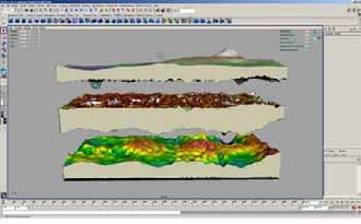

17 Geophysical & Topographic Modeling: A New Approach using 3D Printing and Visualization
 Dendrochronology (Di Naso")
18 Ongoing Research Endeavors: Provenance: Sherd Analyses Geophysical Modeling Techniques Great Kiva Reconstruction (Jerez Di Naso) Dendrochronology (Di Naso Weber)
19 Acknowledgements For not the participation of the following individuals, neither this endeavor nor this report would have been possible, I thank all of them kindly Vincent P. Gutowski, Eastern Illinois University; for his guidance and support, and more importantly for introducing me to Don and David Dove. Don and David Dove; for the opportunity to partake in this project and for their inspiration, with which has provided a renewed insight and interest in southwestern archaeology. Harvey Henson, Southern Illinois University; for providing geophysical equipment and training and support, his knowledge on the subject undoubtedly contributing in large part, the success of the archaeological excavations. Ray and Bernie Kara, Ryan Leonard, Paul Hughes and Emin Emini of Kara Company, Countryside, IL; for their more than gracious support in providing Global Positioning System and Total Station equipment, their collective contributions allowing us to map the Champagne Springs Ruins. Dan Weber, Scott Robinson, Alex Jerez, Imaging Technology Group, Beckman Institute; for providing Environmental Scanning Electron Microscopy, visualization and 3D modeling / reconstruction, and in the creation of the first and only 3D models and animations of the Champagne Springs Ruins. EIU Students; for their participation in the mapping of the Champagne Springs Ruins.
20 Archaeological Prospecting: Geophysical Methods using 3D Modeling Techniques, Champagne Springs Ruins, Dolores County, Colorado AUTHORS Steven M Di Naso Eastern Illinois University sdinaso@eiu.edu Harvey Henson Southern Illinois University henson@geo.siu.edu Don Dove Mitchell Springs Ruins ddove@sisna.net David Dove Mitchell Springs Ruins ddove@sisna.net Alex Jerez Beckman Institute: UIUC Image Technology Group ajerez@itg.uiuc.edu Dan Weber Beckman Institute: UIUC Image Technology Group dweber@itg.uiuc.edu
AN ARCHAEOLOGICAL SURVEY OF THE EVERETT/ TAYLOR PROPERTY NEAR CORTEZ, CO
 AN ARCHAEOLOGICAL SURVEY OF THE EVERETT/ TAYLOR PROPERTY NEAR CORTEZ, CO The Mitchell Springs Community Survey at Magic Rock David M. Dove March 2012 Acknowledgement Through the generous support of Kim
Geophysical Investigation of a 19th Century Archeological Site, Boston College K. Corcoran, J. Hager, M. Carnevale
 Geophysical Investigation of a 19th Century Archeological Site, Boston College K. Corcoran, J. Hager, M. Carnevale Hager GeoScience, Inc., Waltham, MA ------------------------------------------------------------------------
Geoarchaeology and Geophysics at Feltus
 Geoarchaeology and Geophysics at Feltus Sarah C. Sherwood (Department of Anthropology, University of the South, Sewanee) Bryan S. Haley (Center for Archaeological Research, University of Mississippi) Jay
GPR SURVEYS AT SOME 700 YEARS-OLD STRUCTURES IN THE OLD CITY OF CAIRO, EGYPT.
 GPR SURVEYS AT SOME 700 YEARS-OLD STRUCTURES IN THE OLD CITY OF CAIRO, EGYPT. Mohamed G. El-Behiry Geophysics Department, Faculty of Science, Cairo University, Giza, Egypt. Abstract Remediation and restoration
Combined Geophysical Survey of an Ancient Hittite Dam: New and Old High-Tech
 Geophysical Prospecting 1 Ercan Erkul Andreas Hüser Harald Stümpel Tina Wunderlich Combined Geophysical Survey of an Ancient Hittite Dam: New and Old High-Tech Abstract: Investigating ancient living conditions
Ground Penetrating Radar Survey of a Portion of East End Cemetery, Cadiz, Kentucky
 Ground Penetrating Radar Survey of a Portion of East End Cemetery, Cadiz, Kentucky January 2011 Report prepared by Anthony L. Ortmann, Ph.D. Assistant Professor Department of Geosciences Murray State University
Chapter 5 LiDAR Survey and Analysis in
 Chapter 5 LiDAR Survey and Analysis in 2010-2011 Christopher Fennell A surveyor s plat and town plan filed in 1836 set out an intended grid of blocks, lots, alleys, and streets for New Philadelphia. Geophysical,
POTASH DRAGON CHILE GEOPHYSICAL SURVEY TRANSIENT ELECTROMAGNETIC (TEM) METHOD. LLAMARA and SOLIDA PROJECTS SALAR DE LLAMARA, IQUIQUE, REGION I, CHILE
 METHOD. LLAMARA and SOLIDA PROJECTS SALAR DE LLAMARA, IQUIQUE, REGION I, CHILE") POTASH DRAGON CHILE GEOPHYSICAL SURVEY TRANSIENT ELECTROMAGNETIC (TEM) METHOD LLAMARA and SOLIDA PROJECTS SALAR DE LLAMARA, IQUIQUE, REGION I, CHILE OCTOBER 2012 CONTENT Page I INTRODUCTION 1 II FIELD
POTASH DRAGON CHILE GEOPHYSICAL SURVEY TRANSIENT ELECTROMAGNETIC (TEM) METHOD LLAMARA and SOLIDA PROJECTS SALAR DE LLAMARA, IQUIQUE, REGION I, CHILE OCTOBER 2012 CONTENT Page I INTRODUCTION 1 II FIELD
TOPOGRAPHICAL MAPPING, GEOPHYSICAL STUDIES AND ARCHAEOLOGICAL TESTING OF AN EARLY PUEBLO II VILLAGE NEAR DOVE CREEK, COLORADO
 TOPOGRAPHICAL MAPPING, GEOPHYSICAL STUDIES AND ARCHAEOLOGICAL TESTING OF AN EARLY PUEBLO II VILLAGE NEAR DOVE CREEK, COLORADO PREPARED BY: DONALD E. DOVE, PRINCIPAL INVESTIGATOR WITH CONTRIBUTIONS BY STEVEN
ACQUISITION, PROCESSING AND INTERPRETATION TECHNIQUES FOR GROUND-PENETRATING RADAR MAPPING OF BURIED PIT-STRUCTURES IN THE AMERICAN SOUTHWEST
 ACQUISITION, PROCESSING AND INTERPRETATION TECHNIQUES FOR GROUND-PENETRATING RADAR MAPPING OF BURIED PIT-STRUCTURES IN THE AMERICAN SOUTHWEST Lawrence B. Conyers Deparunent of Anthropology, University
THE USE OF GEOMATICS IN CULTURAL HERITAGE AND ARCHAEOLOGY FOR VARIOUS PURPOSES
 THE USE OF GEOMATICS IN CULTURAL HERITAGE AND ARCHAEOLOGY FOR VARIOUS PURPOSES FEBRUARY 2013 AL BEIDA GEOPLAN CONTENT Company Profile Concept Objectives and Strategies Data Production Methods Data Samples
MINNESOTA DEEP TEST PROTOCOL PROJECT
 MINNESOTA DEEP TEST PROTOCOL PROJECT Mn/DOT Agreement No. 85878 OSA License No. 04-030 Authorized and Sponsored by: MINNESOTA DEPARTMENT OF TRANSPORTATION FEDERAL HIGHWAY ADMINISTRATION Prepared by COMMONWEALTH
Marine Geophysical Methods: What Can and Cannot Be Done to Iden8fy Hazards to Dredging & Marine Construc8on
 Marine Geophysical Methods: What Can and Cannot Be Done to Iden8fy Hazards to Dredging & Marine Construc8on Marine Geophysics Sham or Savior? Seen alternatively as the silver bullet or snake oil, marine
Geophysical Survey of Wisconsin Burial Site BRO-0033 Wixom Cemetery, Rock County, Wisconsin
 Lawrence University Lux Archaeological Reports Anthropology Department 6-2015 Geophysical Survey of Wisconsin Burial Site BRO-0033 Wixom Cemetery, Rock County, Wisconsin Peter N. Peregrine Lawrence University
Site Characterization & Hydrogeophysics
 Site Characterization & Hydrogeophysics (Source: Matthew Becker, California State University) Site Characterization Definition: quantitative description of the hydraulic, geologic, and chemical properties
Tecate Commercial Vehicle Enforcement Facility Project: Increasing Efficiency of Geophysical Survey Billy A. Silva
 Tecate Commercial Vehicle Enforcement Facility Project: Increasing Efficiency of Geophysical Survey Billy A. Silva Introduction A geophysical survey of CA-SDI-16,798 in San Diego County, California was
Prehistoric Clay Sources: A Forensic Exercise in Geoarchaeology
 Prehistoric Clay Sources: A Forensic Exercise in Geoarchaeology Lynn Ketterhagen Faculty Sponsor: Dean Wilder, Department of Geography and Earth Science ABSTRACT The prehistoric Oneota culture of the Upper
Archaeological Glossary
 Archaeological Glossary analysis: the stage of archaeological research that involves the description and classification of archaeological data. anthropology: the study of humans, including the variety
Work Conducted in August 2018
 Kelly Nieforth Economic Development Manager City of Oshkosh 215 Church Avenue Oshkosh, W 54903 August 31, 2018 RE: Update #9: August 1 to 31, 2018 Archaeological Data Recovery at the Golf Course Site (47WN0049)
Archaeology and Geophysics at the Chillicothe Site, Ohio, USA
 info@gemsys.on.ca Archaeology and Geophysics at the Chillicothe Site, Ohio, USA In this short paper, we summarize the recent procedings of the National Parks Service Archaeology Workshop in Chillicothe,
Geological Mapping using Geophysics
 Geological Mapping using Geophysics Pugin, A.J.M. and T.H. Larson Illinois State Geological Survey, 615 E Peabody Dr., Champaign, IL 61820; E-mail: A.J.M. Pugin at pugin@isgs.uiuc.edu Mapping Techniques.
EXTREMELY FAST IP USED TO DELINEATE BURIED LANDFILLS. Norman R. Carlson, Cris Mauldin Mayerle, and Kenneth L. Zonge
 EXTREMELY FAST IP USED TO DELINEATE BURIED LANDFILLS Norman R. Carlson, Cris Mauldin Mayerle, and Kenneth L. Zonge Zonge Engineering and Research Organization, Inc. 3322 East Fort Lowell Road Tucson, Arizona,
APPENDIX B: REPORT ON GEOPHYSICAL SURVEY, JULY 1998
 APPENDIX B: REPORT ON GEOPHYSICAL SURVEY, JULY 1998 by Andy Payne Introduction A geophysical survey was carried out at Le Yaudet, Ploulec h, Brittany as part of the ongoing investigation into the archaeology
Geophysical Survey Report
 Geophysical Survey Report Wickham Bushes, Bracknell, Berkshire for Thames Valley Archaeological Services December 2004 J1957 K T Donaldson Document Title: Client: Stratascan Job No: Techniques: Geophysical
A GPR ASSESSMENT OF THE PREHISTORIC NAPLES CANAL NAPLES, FLORIDA ARCHAEOLOGICAL AND HISTORICAL CONSERVANCY, INC.
 A GPR ASSESSMENT OF THE PREHISTORIC NAPLES CANAL NAPLES, FLORIDA ARCHAEOLOGICAL AND HISTORICAL CONSERVANCY, INC. AHC TECNICAL REPORT NO. 1004 DECEMBER 2013 A GPR ASSESSMENT OF THE PREHISTORIC NAPLES CANAL
An Investigation of New Philadelphia Using Thermal Infrared Remote Sensing. (Last updated: Nov. 25, 2008)
") An Investigation of New Philadelphia Using Thermal Infrared Remote Sensing (Last updated: Nov. 25, 2008) Bryan S. Haley Center for Archaeological Research University of Mississippi Research results in
An Investigation of New Philadelphia Using Thermal Infrared Remote Sensing (Last updated: Nov. 25, 2008) Bryan S. Haley Center for Archaeological Research University of Mississippi Research results in
This Unit is suitable for candidates with no previous archaeological experience but who have an interest in history and/or archaeology.
 National Unit specification: general information Unit code: H29B 12 Superclass: DC Publication date: August 2012 Source: Scottish Qualifications Authority Version: 01 Summary This Unit introduces candidates
PHASE 1 STUDIES UPDATE EROSION WORKING GROUP
 PHASE 1 STUDIES UPDATE EROSION WORKING GROUP Presented By MICHAEL WOLFF, PG Erosion Study Area Manager West Valley Demonstration Project Quarterly Public Meeting February 24, 2016 OUTLINE Study 1 Terrain
Using Ground Conductivity as a Geophysical Survey Technique to Locate Potential Archaeological Sites in the Bad Axe River Valley of Western Wisconsin
 Using Ground Conductivity as a Geophysical Survey Technique to Locate Potential Archaeological Sites in the Bad Axe River Valley of Western Wisconsin Anthony J. Beauchaine, Elizabeth Werdemann Faculty
New Research Exploring the Origins of Sanxingdui
 New Research Exploring the Origins of Sanxingdui The Harvard community has made this article openly available. Please share how this access benefits you. Your story matters. Citation Published Version
Module 4, Investigation 1: Briefing 1 Photographs Chaco Canyon
 Module 4, Investigation 1: Briefing 1 Photographs Chaco Canyon Study the photographs to identify physical features of the region. What is the land like? What type of climate exists in this region? The
GEOL4714 Final Exam Fall 2005, C. H. Jones instructor
 GEOL4714 Final Exam Fall 2005 p. 1 GEOL4714 Final Exam Fall 2005, C. H. Jones instructor Name: Student ID #: Feel free to use the back of the sheets for answers needing more space. (1) (10 pts) For each
High Resolution Geophysics: A Better View of the Subsurface. By John Jansen, P.G., Ph.D., Aquifer Science and Technology
 High Resolution Geophysics: A Better View of the Subsurface By John Jansen, P.G., Ph.D., Aquifer Science and Technology Geologist Use Only Part of the Information Available To Them Most Geologist rely
MAPPING BEDROCK: Verifying Depth to Bedrock in Calumet County using Seismic Refraction
 MAPPING BEDROCK: Verifying Depth to Bedrock in Calumet County using Seismic Refraction Revised December 13, 2011 Dave Hart Wisconsin Geological and Natural History Survey INTRODUCTION Seismic refraction
Applied Geophysics for Environmental Site Characterization and Remediation
 Applied Geophysics for Environmental Site Characterization and Remediation MSECA Webinar September 24, 2015 John Mundell, P.E., L.P.G. Ryan Brumbaugh, L.P.G. MUNDELL & ASSOCIATES, INC. Webinar Objective
Texas Prehistoric Archeology. TPWD Cultural Resources Coordinator (a.k.a. Archeologist)
") Texas Prehistoric Archeology TPWD Cultural Resources Coordinator (a.k.a. Archeologist) Prehistory Definition Prehistory is that time when man first came to North America (~12,000 BP [years before present])
Texas Prehistoric Archeology TPWD Cultural Resources Coordinator (a.k.a. Archeologist) Prehistory Definition Prehistory is that time when man first came to North America (~12,000 BP [years before present])
General Geologic Setting and Seismicity of the FHWA Project Site in the New Madrid Seismic Zone
 General Geologic Setting and Seismicity of the FHWA Project Site in the New Madrid Seismic Zone David Hoffman University of Missouri Rolla Natural Hazards Mitigation Institute Civil, Architectural & Environmental
Comparison of geophysical. techniques to determine depth to. bedrock in complex weathered. environments of the Mount Crawford. region, South Australia
 Comparison of geophysical techniques to determine depth to bedrock in complex weathered environments of the Mount Crawford region, South Australia Thesis submitted in accordance with the requirements of
SECOND HOMEWORK ASSIGNMENT Absolute and Relative Dating Methods
 Tulane University Chris Rodning NAME INTRODUCTION TO ARCHAEOLOGY ANTH 334 F2008 SCORE of 40 points SECOND HOMEWORK ASSIGNMENT Absolute and Relative Dating Methods Answer the following questions about dating
APPENDIX G GLOSSARY. Mn/DOT/WR-0200
 APPENDIX G GLOSSARY Mn/DOT/WR-0200 Alluvial - comprised of clay, silt, sand, gravel, and/or other detritus deposited by water. Usually refers to accretionary overbank, floodplain or levee deposits. Biomantling
Virtual Georadar Modelling of Significant Archaeological Sites
 Geophysical Prospecting 1 Anna Klochko Dmitry Shishkov Virtual Georadar Modelling of Significant Archaeological Sites Abstract: 3D modelling of archaeological sites and historical objects with non-destructive
GEOPHYSICAL SITE CHARACTERIZATION IN SUPPORT OF HIGHWAY EXPANSION PROJECT
 GEOPHYSICAL SITE CHARACTERIZATION IN SUPPORT OF HIGHWAY EXPANSION PROJECT * Shane Hickman, * Todd Lippincott, * Steve Cardimona, * Neil Anderson, and + Tim Newton * The University of Missouri-Rolla Department
ELECTRICAL RESISTIVITY SURVEYS AT THE ANDERSON RESIDENCE SITE, PORT CLYDE, ME. For: St.Germain-Collins
 ELECTRICAL RESISTIVITY SURVEYS AT THE ANDERSON RESIDENCE SITE, PORT CLYDE, ME For: St.Germain-Collins 4 Union Street, Suite 3 Bangor, Maine 441 July, 218 ELECTRICAL RESISTIVITY SURVEYS AT THE ANDERSON
Remote Sensing and Geographic Information System (GIS) Based Analysis of Historic Resources
 Based Analysis of Historic Resources") World War II Additional Material Remote Sensing and Geographic Information System (GIS) Based Analysis of Historic Resources By Nicole Vernon and Patrick O Day, GANDA Remote Sensing and Geographic Information
World War II Additional Material Remote Sensing and Geographic Information System (GIS) Based Analysis of Historic Resources By Nicole Vernon and Patrick O Day, GANDA Remote Sensing and Geographic Information
Lapita and Later Archaeology of the Malolo and Mamanuca Islands, Fiji
 Journal of Island & Coastal Archaeology, 2:245 250, 2007 Copyright 2007 Taylor & Francis Group, LLC ISSN: 1556-4894 print / 1556-1828 online DOI:10.1080/15564890701622896 Lapita and Later Archaeology of
Correlation of gravel deposits from trenching project on Alder Creek fluvial terrace near Point Arena, California
 Correlation of gravel deposits from trenching project on Alder Creek fluvial terrace near Point Arena, California Aletha Lee Department of Geology and Geography, West Virginia University, White Hall, Morgantown,
Geophysical Survey Report
 Report Lost Mansion of Nydfwch, Penllergare, Swansea for January 2008 J2449 John Cook BSc. (Hons) Document Title: Client: Stratascan Job No: Techniques: Report Lost Mansion of Nydfwch, Penllergare, Swansea
Geophysics for Environmental and Geotechnical Applications
 Geophysics for Environmental and Geotechnical Applications Dr. Katherine Grote University of Wisconsin Eau Claire Why Use Geophysics? Improve the quality of site characterization (higher resolution and
FINAL REPORT GEOPHYSICAL INVESTIGATION WATER TOWER NO. 6 SITE PLANT CITY, FL
 APPENDIX B FINAL REPORT GEOPHYSICAL INVESTIGATION WATER TOWER NO. 6 SITE PLANT CITY, FL Prepared for Madrid Engineering Group, Inc. Bartow, FL Prepared by GeoView, Inc. St. Petersburg, FL February 28,
INTRODUCTION TO APPLIED GEOPHYSICS
 INTRODUCTION TO APPLIED GEOPHYSICS EXPLORING THE SHALL0W SUBSURFACE H. Robert Burger Anne F. Sheehan Craig H.Jones VERSITY OF COLORADO VERSITY OF COLORADO W. W. NORTON & COMPANY NEW YORK LONDON Contents
CHAPTER 4. Blue Heron Site (47Je1001) 2003 Investigations. By Chrisie L. Hunter
 2003 Investigations. By Chrisie L. Hunter") CHAPTER 4 Blue Heron Site (47Je1001) 2003 Investigations By Chrisie L. Hunter Introduction The Blue Heron site (47Je1001) is on the property of the Crescent Bay Hunt Club, which is located in the NE 1/4
CHAPTER 4 Blue Heron Site (47Je1001) 2003 Investigations By Chrisie L. Hunter Introduction The Blue Heron site (47Je1001) is on the property of the Crescent Bay Hunt Club, which is located in the NE 1/4
APPENDIX A: Magnetotelluric Data in Relation to San Pedro Mesa Structural. The San Pedro Mesa structural high (discussed in main text of paper) was
 was") Page of DR for GSA Special Paper 9, Chapter, Geophysical constraints APPENDIX A: Magnetotelluric Data in Relation to San Pedro Mesa Structural High The San Pedro Mesa structural high (discussed in main
Page of DR for GSA Special Paper 9, Chapter, Geophysical constraints APPENDIX A: Magnetotelluric Data in Relation to San Pedro Mesa Structural High The San Pedro Mesa structural high (discussed in main
In 1998, salvage archaeological investigations began on the bank of the Miami River
 1 Imaging Sub-surface Features of the Miami Circle with Ground Penetrating Radar Jessie Pincus a, Robert S. Carr b, Dean Whitman c Ground Penetrating Radar (GPR) is a high-resolution near-surface geophysical
Geophysical prospection and aerial photography in La Laguna, Tlaxcala, Mexico
 ArcheoSciences Revue d'archéométrie 33 (suppl.) 2009 Mémoire du sol, espace des hommes Geophysical prospection and aerial photography in La Laguna, Tlaxcala, Mexico Luis Barba, Jorge Blancas, Agustin Ortiz
GPR surveys at Nõmmküla Detection of underground water routes
 GPR surveys at Nõmmküla 2009 Detection of underground water routes Tomi Herronen & Timo Saarenketo 2009 1. Introduction The purpose of this survey was to locate possible underground water routes (rivers)
Ground-Penetrating Radar
 7 Ground-Penetrating Radar Lawrence B. Conyers Ground-penetrating radar (GPR) has recently gained a wide acceptance in the archaeological community as a method that can quickly and accurately locate buried
Council for West Virginia Archaeology Spring Workshop Charleston, West Virginia June 7, 2003
 GEOPHYSICAL DETECTION OF GRAVES BASIC BACKGROUND AND CASE HISTORIES FROM HISTORIC CEMETERIES By William J. Johnson 1 Abstract The identification of graves is an important issue at many historical cemeteries.
Resistivity survey at Stora Uppåkra, Sweden
 Resistivity survey at Stora Uppåkra, Sweden Dahlin, Torleif Published in: Uppåkra - Centrum i analys och rapport 2001 Link to publication Citation for published version (APA): Dahlin, T. (2001). Resistivity
Geophysical Investigation of Ground Water Using Vertical Electrical Sounding and Seismic Refraction Methods
 International Journal of Petroleum and Petrochemical Engineering (IJPPE) Volume 2, Issue 1, 2016, PP 6-11 ISSN 2454-7980 (Online) www.arcjournals.org Geophysical Investigation of Ground Water Using Vertical
December 13, Kirk Shields Green Mountain Power 163 Acorn Lane Colchester, VT 05446
 December 13, 2017 Kirk Shields Green Mountain Power 163 Acorn Lane Colchester, VT 05446 RE: End of Field Letter for Archaeological Phase II Site Evaluation at Site VT-CH-1218 within the Proposed Milton
Report on Geophysical Survey Na Vrsku, Sahy, Slovakia Coordinates: 48⁰,4,45 N 18⁰,56,23 E. April 2018
 Report on Geophysical Survey Na Vrsku, Sahy, Slovakia Coordinates: 48⁰,4,45 N 18⁰,56,23 E April 2018 Mark Graham BA(Hons), BSc, MA Grampus Heritage and Training Ltd, Ashgill, Threapland, Wigton, Cumbria,
Application of Remote Sensing and GIS in Seismic Surveys in KG Basin
 P-318 Summary Application of Remote Sensing and GIS in Seismic Surveys in KG Basin M.Murali, K.Ramakrishna, U.K.Saha, G.Sarvesam ONGC Chennai Remote Sensing provides digital images of the Earth at specific
MAPPING POTENTIAL LAND DEGRADATION IN BHUTAN
 MAPPING POTENTIAL LAND DEGRADATION IN BHUTAN Moe Myint, Geoinformatics Consultant Rue du Midi-8, CH-1196, Gland, Switzerland moemyint@bluewin.ch Pema Thinley, GIS Analyst Renewable Natural Resources Research
FINAL REPORT GEOPHYSICAL INVESTIGATION VILLAGE ALHAMBRA RETENTION POND SITE THE VILLAGES, FLORIDA
 FINAL REPORT GEOPHYSICAL INVESTIGATION VILLAGE ALHAMBRA RETENTION POND SITE THE VILLAGES, FLORIDA Prepared for Andreyev Engineering, Inc. Oxford, FL Prepared by GeoView, Inc. St. Petersburg, FL August
United States Natural Resources 344 Merrow Road Department of Conservation Service Suite A Agriculture Service Tolland, CT 06084
 United States Natural Resources 344 Merrow Road Department of Conservation Service Suite A Agriculture Service Tolland, CT 06084 SUBJECT: Archaeology Geophysical Field Assistance January 6, 2015 TO: Dr.
Friends of Petrified Forest National Park
 I S S U E 2, N O V E M B E R 2 0 1 2 Friends of Petrified Forest National Park Working together we can make a difference! Revueltosaurus Quarry, June 2012. Exceptional Findings at Petrified Forest National
Pierce Cedar Creek Institute GIS Development Final Report. Grand Valley State University
 Pierce Cedar Creek Institute GIS Development Final Report Grand Valley State University Major Goals of Project The two primary goals of the project were to provide Matt VanPortfliet, GVSU student, the
The Preliminary Study of Meteorite Impact Crater at Bukit Bunuh, Lenggong
 2012 International Conference on Geological and Environmental Sciences IPCBEE vol.3 6(2012) (2012)IACSIT Press, Singapoore The Preliminary Study of Meteorite Impact Crater at Bukit Bunuh, Lenggong A. H.
Ground subsidence is a worldwide problem especially
 Ground Engineering: GPR A Case Study on Ground Subsidence Using Ground Penetrating Radar Nur Azwin Ismail and Rosli Saad Geophysics Section, School of Physics, Universiti Sains Malaysia Ground subsidence
DATING HOW OLD IS THIS THING?
 DATING HOW OLD IS THIS THING? WHY? u CROSS-CULTURAL COMPARISON v UNDERSTANDING DEVELOPMENT AND CHANGE OF A PARTICULAR GROUP OR CULTURE w UNDERSTANDING SITE FORMATION PROCESSES x UNDERSTANDING REGIONAL
Earth s Continents and Seafloors. GEOL100 Physical Geology Ray Rector - Instructor
 Earth s Continents and Seafloors GEOL100 Physical Geology Ray Rector - Instructor OCEAN BASINS and CONTINENTAL PLATFORMS Key Concepts I. Earth s rocky surface covered by of two types of crust Dense, thin,
Thames Valley University, Kings Road, Reading, Berkshire
 Thames Valley University, Kings Road, Reading, Berkshire An Archaeological Evaluation for Thames Valley University by Danielle Milbank and Steve Ford Thames Valley Archaeological Services Ltd Site Code
Georadar and geoelectricity method to identify the determine zone of sliding landslide
 IOP Conference Series: Earth and Environmental Science PAPER OPEN ACCESS Georadar and geoelectricity method to identify the determine zone of sliding landslide To cite this article: Y K Dalimunthe and
Module 4 Educator s Guide Overview
 Module 4 Educator s Guide Overview Remote sensing and geoarchaeology: How do remotely sensed images help us to understand past cultures? Module Overview This module explores ways geographers and geoarchaeologists
GLG 471; MICHIGAN STATE UNIVERSITY INSTRUCTOR R.L. VAN DAM PROJECT: ELECTRICAL RESISTIVITY
 GLG 471; MICHIGAN STATE UNIVERSITY INSTRUCTOR R.L. VAN DAM PROJECT: ELECTRICAL RESISTIVITY General information: This is a group (2-3 students) project requiring lab-, computer-, and fieldwork. Work will
Use of Ground Penetrating Radar to identify the presence and orientation of Graves in St. Brigitts Cemetery, Bergen New York
 The College at Brockport: State University of New York Digital Commons @Brockport Geotechnical Survey Reports Department of the Earth Sciences 2013 Use of Ground Penetrating Radar to identify the presence
Ground Penetrating Radar Survey Report: Follow-up Ground Truth Study
 Ground Penetrating Radar Survey Report: Follow-up Ground Truth Study 2005 Tell es-safi/gath Archaeological Project Figure 1: Tell es-safi GPR ground-truth study. Data Acquired August 4, 2005 Report compiled
AN ARCHAEOLOGICAL SURVEY FOR THE EASTHAM STATE PRISON FARM UNIT PROJECT IN HOUSTON COUNTY TEXAS
 AN ARCHAEOLOGICAL SURVEY FOR THE EASTHAM STATE PRISON FARM UNIT PROJECT IN HOUSTON COUNTY TEXAS Antiquities Permit 5693 By William E. Moore and Edward P. Baxter Brazos Valley Research Associates Contract
Soils, Hydrogeology, and Aquifer Properties. Philip B. Bedient 2006 Rice University
 Soils, Hydrogeology, and Aquifer Properties Philip B. Bedient 2006 Rice University Charbeneau, 2000. Basin Hydrologic Cycle Global Water Supply Distribution 3% of earth s water is fresh - 97% oceans 1%
P60 High Resolution Geophysics Inside Machado de Castro Museum - Coimbra, Centre Portugal
 P60 High Resolution Geophysics Inside Machado de Castro Museum - Coimbra, Centre Portugal C. Grangeia (University of Aveiro), M.J. Senos Matias* (University of Aveiro), F. Figueiredo (University of Coimbra),
Use of Geophysical Software for Interpretation of Ice-Penetrating Radar Data and Mapping of Polar Ice Sheets
 Use of Geophysical Software for Interpretation of Ice-Penetrating Radar Data and Mapping of Polar Ice Sheets Alex O. Martinez University of Kansas 2335 Irving Hill Road Lawrence, KS 66045-7612 http://cresis.ku.edu
Geophysics Course Introduction to DC Resistivity
 NORAD supported project in MRRD covering Capacity Building and Institutional Cooperation in the field of Hydrogeology for Faryab Province Afghanistan Geophysics Course Introduction to DC Resistivity By
Electrical imaging techniques for hydrological and risk assessment studies
 Séminaire IPG le 9 mars 2006 Strasbourg Institute of Geophysics ETH Hoenggerberg CH-8093 Zurich Electrical imaging techniques for hydrological and risk assessment studies Laurent Marescot laurent@aug.ig.erdw.ethz.ch
Application of geophysics to North American prehistoric sites
 first break volume 24, June 2006 Application of geophysics to North American prehistoric sites William J. Johnson 1 and Donald W. Johnson, 2 members of the US-based Archaeology and Geophysics Consortium,
Geophysical Investigation of Foundation Condition of A Site in Ikere- Ekiti, Ekiti State, South-Western Nigeria
 Australian Journal of Basic and Applied Sciences, 5(9): 1852-1857, 2011 ISSN 1991-8178 Geophysical Investigation of Foundation Condition of A Site in Ikere- Ekiti, Ekiti State, South-Western Nigeria 1
GEOPHYSICAL IMAGING TO ENHANCE ANALYSIS, DESIGN AND DRILLING OF LARGE-SCALE GEOTHERMAL SYSTEMS. Abstract
 GEOPHYSICAL IMAGING TO ENHANCE ANALYSIS, DESIGN AND DRILLING OF LARGE-SCALE GEOTHERMAL SYSTEMS John A. Mundell, Mundell & Associates, Inc., Indianapolis, Indiana Gabriel Hebert, Mundell & Associates, Inc.,
Name. Designed and Produced for the Orleans County Historical Society by Andrew R. Beaupré, RPA
 Name Archaeology! Archeology! What is Archaeology? Archaeology is the scientific study of people of the past by studying the places people lived, the objects they used, and traces in the soil left by human
Changes in bottom morphology of Long Island Sound near Mount Misery Shoal as observed through Repeated Multibeam Surveys
 Changes in bottom morphology of Long Island Sound near Mount Misery Shoal as observed through Repeated Multibeam Surveys Laurie A. Zaleski Laurie.Zaleski@msrc.sunysb.edu Roger D. Flood rflood@notes.cc.sunysb.edu
LAKE SEDIMENT THICKNESS ESTIMATION USING GROUND PENETRATING RADAR
 LAKE SEDIMENT THICKNESS ESTIMATION USING GROUND PENETRATING RADAR Sinam Reema Chanu 1, R.K Chingkhei 2, Manichandra Sanoujam 3, Arun Kumar 4 1 Research Scholar, Department of Earth Sciences, Manipur University,
Turkey, Egypt and Italy
 Remote sensing techniques in geoarchaeological research; Case studies in Turkey, Egypt and Italy V. De Laet*, G. Verstraeten, E. Paulissen Center for Archaeological Sciences, K.U.Leuven Celestijnenlaan
Geophysical Site Investigation (Seismic methods) Amit Prashant Indian Institute of Technology Gandhinagar
 Amit Prashant Indian Institute of Technology Gandhinagar") Geophysical Site Investigation (Seismic methods) Amit Prashant Indian Institute of Technology Gandhinagar Short Course on Geotechnical Aspects of Earthquake Engineering 04 08 March, 2013 Seismic Waves
Geophysical Site Investigation (Seismic methods) Amit Prashant Indian Institute of Technology Gandhinagar Short Course on Geotechnical Aspects of Earthquake Engineering 04 08 March, 2013 Seismic Waves
Application of Geophysics to North American Prehistoric Sites by William J. Johnson PG 1 and Donald W. Johnson 2
 Application of Geophysics to North American Prehistoric Sites by William J. Johnson PG 1 and Donald W. Johnson 2 Introduction Archaeological geophysics, sometime called remote sensing by archaeologists,
SETTLEMENT. Student exercises. The Kuril Biocomplexity Project:
 SETTLEMENT Student exercises Table of Content Vocabulary... 67 Background Information... 69 Introduction... 7 Part 1... 71 Part 2... 8 76 Vocabulary Deposit: Sediment put down on the earth surface in the
ARTIFACT INVENTORIES AND RESEARCH QUESTIONS
 CHAPTER 5 ARTIFACT INVENTORIES AND RESEARCH QUESTIONS Jonathan B. Mabry and J. Homer Thiel Desert Archaeology, Inc. A large number of artifacts were discovered over the course of the Rio Nuevo archaeological
CONTENTS 1. INTRODUCTION. 2. THE D.C. RESISTIVITY METHOD 2.1 Equipment 2.2 Survey Procedure 2.3 Data Reduction
 (i) CONTENTS 1. INTRODUCTION page 1 2. THE D.C. RESISTIVITY METHOD 2.1 Equipment 2.2 Survey Procedure 2.3 Data Reduction 3 3 3 3 3. GEOPHYSICAL RESULTS 3.1 General 3.2 Discussion 4 4 4 4. LIMITATIONS 5
Although most karstic regions
 Urban Geophysics: Geophysical Signature of Mount Bonnell Fault and Its Karstic Features in Austin, TX by Mustafa Saribudak, Environmental Geophysics Associates, Austin, TX Although most karstic regions
A Case Study on Ground Subsidence Using Ground Penetrating Radar
 2012 International Conference on Environmental, Biomedical and Biotechnology IPCBEE vol.41 (2012) (2012) IACSIT Press, Singapore A Case Study on Ground Using Ground Penetrating Radar Nur Azwin Ismail +
A GPR ASSESSMENT OF THE NAPLES CANAL 8CR59: PHASE II NAPLES, FLORIDA ARCHAEOLOGICAL AND HISTORICAL CONSERVANCY, INC.
 A GPR ASSESSMENT OF THE NAPLES CANAL 8CR59: PHASE II NAPLES, FLORIDA ARCHAEOLOGICAL AND HISTORICAL CONSERVANCY, INC. AHC TECNICAL REPORT NO. 1023 JUNE 2014 A GPR ASSESSMENT OF THE NAPLES CANAL 8CR59: PHASE
USE OF GEOPHYSICAL SURVEYS FOR FILL CHARACTERIZATION AND QUANTITY ESTIMATION AT BROWNFIELD SITES A CASE HISTORY. Abstract
 USE OF GEOPHYSICAL SURVEYS FOR FILL CHARACTERIZATION AND QUANTITY ESTIMATION AT BROWNFIELD SITES A CASE HISTORY John A. Mundell, Mundell & Associates, Inc., Indianapolis, IN Gregory B. Byer, Mundell &
The Search for Ancient Helike: a GPR Case Study. Doria L. Kutrubes 1 Radar Solutions International. Steven Soter Smithsonian Institution
 The Search for Ancient Helike: a GPR Case Study Doria L. Kutrubes 1 Radar Solutions International Steven Soter Smithsonian Institution Dora Katsonopoulou American School of Classical Studies at Athens