Using LiDAR ALS data as a supplement to existing cave registry data: an example from NW Gorski kotar, Croatia
|
|
|
- Derrick Stephens
- 5 years ago
- Views:
Transcription


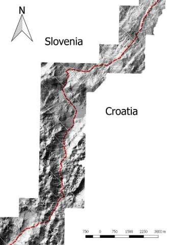
1 Using LiDAR ALS data as a supplement to existing cave registry data: an example from NW Gorski kotar, Croatia D. Grozić 1,3 *, L. Kukuljan 1, N. Bočić 2 1 Speleološka udruga Estavela (Caving Society Estavela ), Kastav, Croatia 2 University of Zagreb, Faculty of Science, Department of Geography, Zagreb, Croatia 3 Priroda Public Institution, Rijeka, Croatia

2 1. Introduction LiDAR From the 1960s Lidar uses light to image objects ALS Fast Accurate Point density pt/m 2 Can see through canopy Source:

3 1. Introduction Made with Qgis 2.18

4 Made with Qgis 2.18 Made with Qgis 2.18

5 2. Study area Made with Qgis 2.18 Source: Google physical map WMS Made with Qgis 2.18
6 2. Study area Remote and hard to reach Low average annual temperatures Source: Zaninović et al. (2008)

7 2. Study area Remote and hard to reach Low average annual temperatures High amount of annual precipitation Source: Zaninović et al. (2008)

8 2. Study area Remote and hard to reach Low average annual temperatures High amount of annual precipitation Many days with snow Source: Zaninović et al. (2008)

9 2. Study area Remote and hard to reach Low average annual temperatures High amount of annual precipitation Many days with snow Very limited time gap suitable for scouting new cave entrances Foto: Dino Grozić

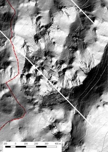
10 2. Study area Complex karst terrain with Jurassic and Cretaceous bedrock Glacio-karst features Made with Qgis 2.18
11 2. Study area Complex karst terrain with Jurassic and Cretaceous bedrock Glacio-karst features Hystory of systematic cave exploration Excellent cave register Source: Caving society Estavela Made with Qgis 2.18

12 2. Study area Complex karst terrain with Jurassic and Cretaceous bedrock Glacio-karst features Hystory of systematic cave exploration Excellent cave register Foto: Lovel Kukuljan
13 3. Methods Point cloud data (LiDAR) Data analysis (FurgoViewer) Classification (by probability) Field work Coordinates correction for known caves Data comparison (existing cave registry) Statistics Conclusions
14 4. Results Data analysis 82 potential entrances Data comparison 21 known entrances 61 potentialy new 26/61 in scouted areas Field work 33 located in the field 28 remain to be found
15 4. Results Data analysis 82 potential entrances Data classification 26 high probability 21 mid probability 35 low probability Statistics 19/20 (95%) 8/14 (57%) 10/20 (50%)


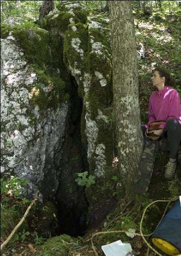
16 Jamica u Praprotnoj dragi
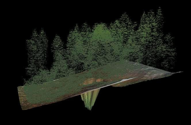

17 Jamica u Praprotnoj dragi


18 Jamica u Praprotnoj dragi Foto: Lovel Kukuljan

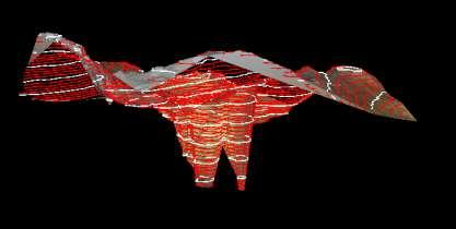
19 Lidar 5


20 Lidar 5

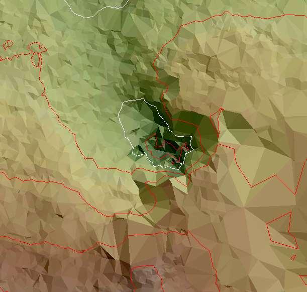
21 Jamica pod Mirakulom


22 Foto: Lovel Kukuljan Foto: Lovel Kukuljan

23 Jamica pod Mirakulom

24 Foto: Dario Maršanić
25 5. Conclusions Using ALS LiDAR data shows great potential in cave entrance identification and cave registry data correction This method is a great supplement to old fashioned scouting for cave entrances, not a substitution Time conserving Ideal for identifiyng anomalies from background terrain Helps decision making
26 5. Conclusions Using 5 pt/m 2 point cloud ALS LiDAR data is most suitable for identifiyng medium and large size vertical cave entrances (>3 x 3 m) Successful identification greatly depends on: Local point density interpreter's skill to correctly identify a cave entrance from the background terrain data

27 Thank you for your attention
28 References Čekada, M., Lidar. Jamar, 8 (1), 54. Čekada, M., Orodja za pogled in obdelavo lidarskih podatkov. Jamar, 8 (1), Čekada, M., Kako natančno določiti koordinate vhoda? Jamar, 9 (1), Čekada, M., Odkrivanje novih jam iz fotelja. Jamar, 9 (1), Čekada, M., Gostinčar, P., Uporaba lidarja v jamarstvu. Digitalni podatki, Mivšek, E., Pegan Žvokelj, B., Bric, V., Triglav Čekada, M., Obreza, A., Tršan, S., Dejak, B., Karničnik, I., Izvedba laserskega skeniranja Slovenije: Blok 12 tehnično poročilo o izdelavi izdelkov. Geodetski inštitut Slovenije. Ljubljana. Triglav Čekada, M., Možnosti uporabe zračnega laserskega skeniranja (LIDAR) za geomorfološke študije. Geografski vestnik, 83-2, Zaninović, K., Gajić-Čapka, M., Perčec Tadić, M., et al., Klimatski atlas Hrvatske / Climate atlas of Croatia , Državni hidrometeorološki zavod. Zagreb. Furgo. FurgoViewer Ver.2.2. April 4,
29 Questions?
Annual runoff estimation an example of karstic aquifers in the transboundary region of Croatia and Slovenia
 Hydrological Sciences Journal ISSN: 0262-6667 (Print) 2150-3435 (Online) Journal homepage: http://www.tandfonline.com/loi/thsj20 Annual runoff estimation an example of karstic aquifers in the transboundary
New climatological normals for Croatia and comparison to previous and normals
 New 1981 2010 climatological normals for Croatia and comparison to previous 1961 1990 and 1971 2000 normals [full paper] Irena Nimac and Melita Perčec Tadić Meteorological and Hydrological Service of Croatia
Climate change in Croatia: observations and modeling
 Climate change in Croatia: observations and modeling Lidija Srnec Meteorological and Hydrological Service Zagreb, CROATIA Selected chapters: Observed climate changes in Croatia (Ksenija Cindrić, Marjana
CHAPTER 3 : A SYSTEMATIC APPROACH TO DECISION MAKING
 CHAPTER 3 : A SYSTEMATIC APPROACH TO DECISION MAKING 47 INTRODUCTION A l o g i c a l a n d s y s t e m a t i c d e c i s i o n - m a k i n g p r o c e s s h e l p s t h e d e c i s i o n m a k e r s a
Spatial Interpolation of Mean Yearly Precipitation using Universal Kriging
 Developments in Statistics Andrej Mrvar and Anuška Ferligoj (Editors) Metodološki zvezki, 17, Ljubljana: FDV, 22 Spatial Interpolation of Mean Yearly Precipitation using Universal Kriging Damijana Kastelec
Landslide Mapping and Hazard Analysis for a Natural Gas Pipeline Project
 CIVIL GOVERNMENT SERVICES MINING & METALS OIL, GAS & CHEMICALS POWER Albert Kottke, Mark Lee, & Matthew Waterman Landslide Mapping and Hazard Analysis for a Natural Gas Pipeline Project Technical Innovation
Drought Vulnerability in Croatia
 ORIGINAL SCIENTIFIC PAPER 31 Drought Vulnerability in Croatia Melita PERČEC TADIĆ ( ) Marjana GAJIĆ-ČAPKA Ksenija ZANINOVIĆ Ksenija CINDRIĆ Summary Drought is the most frequent hazard causing the highest
Effect of land cover / use change on soil erosion assessment in Dubračina catchment (Croatia)
") European Water 57: 171-177, 2017. 2017 E.W. Publications Effect of land cover / use change on soil erosion assessment in Dubračina catchment (Croatia) N. Dragičević *, B. Karleuša and N. Ožanić Faculty
European Water 57: 171-177, 2017. 2017 E.W. Publications Effect of land cover / use change on soil erosion assessment in Dubračina catchment (Croatia) N. Dragičević *, B. Karleuša and N. Ožanić Faculty
6TH INTERNATIONAL WORKSHOP ON ICE CAVES
 NATIONAL CAVE AND KARST RESEARCH INSTITUTE SYMPOSIUM 4 6TH INTERNATIONAL WORKSHOP ON ICE CAVES August 17 through 22, 2014 Idaho Falls, Idaho, USA EDITORS: Lewis Land New Mexico Bureau of Geology and Mineral
Quenching the Valley s thirst: The connection between Sierra Nevada snowpack & regional water supply
 Quenching the Valley s thirst: The connection between Sierra Nevada snowpack & regional water supply Roger Bales, UC Merced Snow conditions Snow & climate change Research directions Sierra Nevada snow
ESTIMATON OF MAXIMUM SHORT-TERM PRECIPITATION OVER THE RIJEKA REGION
 ESTIMATON OF MAXIMUM SHORT-TERM PRECIPITATION OVER THE RIJEKA REGION Marjana Gajić-Čapka Meteorological and Hydrological Service of Croatia, Ph.D. Nevenka Ožanić University of Rijeka, Faculty of Civil
Historical development of erosion control works (more than 100 years) Wild torrent management is essential for the existance of human in alpine areas
 Wild torrent management is essential for the existance of human in alpine areas") Rev. 2004.07 Slovenia Historical development of erosion control works (more than 100 years) Wild torrent management is essential for the existance of human in alpine areas of Slovenia Some historical data
Rev. 2004.07 Slovenia Historical development of erosion control works (more than 100 years) Wild torrent management is essential for the existance of human in alpine areas of Slovenia Some historical data
Research on Topographic Map Updating
 Research on Topographic Map Updating Ivana Javorovic Remote Sensing Laboratory Ilica 242, 10000 Zagreb, Croatia Miljenko Lapaine University of Zagreb, Faculty of Geodesy Kaciceva 26, 10000 Zagreb, Croatia
Some experiences with alien plant mapping in Slovenia. Mario Lešnik Faculty of Agriculture and Life Sciences University of Maribor, Slovenia
 Some experiences with alien plant mapping in Slovenia Mario Lešnik Faculty of Agriculture and Life Sciences University of Maribor, Slovenia Mapping is one of the middle steps in process of ivasive plant
MONITORING AND THE RESEARCH ON METEOROLOGICAL DROUGHT IN CROATIA
 MONITORING AND THE RESEARCH ON METEOROLOGICAL DROUGHT IN CROATIA K. Cindrić Kalin, I. Güttler, L. Kalin, D. Mihajlović, T. Stilinović Meteorological and Hydrological Service cindric@cirus.dhz.hr 1 overview
Geophysical Case studies From Texas
 Geophysical Case studies From Texas 1 PRESENTATION OUTLINE Active Growth Faults in Metropolitan Houston 1. Hockley 2. Tomball 3. Long Point 4. Pearland Foundation Case Studies Karst Geophysics in Austin:
Climate Change and Vegetation Phenology
 Climate Change and Vegetation Phenology Climate Change In the Northeastern US mean annual temperature increased 0.7 C over 30 years (0.26 C per decade) Expected another 2-6 C over next century (Ollinger,
An update on CMIP(6), obs4mips and the WGCM/WGNE Diagnostics and Metrics Panel
, obs4mips and the WGCM/WGNE Diagnostics and Metrics Panel") An update on CMIP(6), obs4mips and the WGCM/WGNE Diagnostics and Metrics Panel Peter J. Gleckler WGNE 31, Pretoria, South Africa, April 27, 2016 REMOTE PRESENTATION Talk outline 2 CMIP6 status obs4mips
An update on CMIP(6), obs4mips and the WGCM/WGNE Diagnostics and Metrics Panel Peter J. Gleckler WGNE 31, Pretoria, South Africa, April 27, 2016 REMOTE PRESENTATION Talk outline 2 CMIP6 status obs4mips
Slovenian Chemical Society. Venčeslav Kaučič
 Slovenian Chemical Society Venčeslav Kaučič Bled, 15 October 2010 Outline of presentation Facts about Slovenia Slovenian Chemical Society Acta Chimica Slovenica Chemical Industry in Slovenia Republic of
A Cloud-Based Flood Warning System For Forecasting Impacts to Transportation Infrastructure Systems
 A Cloud-Based Flood Warning System For Forecasting Impacts to Transportation Infrastructure Systems Jon Goodall Associate Professor, Civil and Environmental Engineering Associate Director, Link Lab April
Denver International Airport MDSS Demonstration Verification Report for the Season
 Denver International Airport MDSS Demonstration Verification Report for the 2015-2016 Season Prepared by the University Corporation for Atmospheric Research Research Applications Division (RAL) Seth Linden
SolarGIS: Online Access to High-Resolution Global Database of Direct Normal Irradiance
 SolarGIS: Online Access to High-Resolution Global Database of Direct Normal Irradiance Marcel Suri PhD Tomas Cebecauer, PhD GeoModel Solar Bratislava, Slovakia Conference Conference SolarPACES 2012, 13
The National Weather Service of the Future: Building a Weather-Ready Nation
 The of the Future: Building a Weather-Ready Nation Dr. Louis W. Uccellini Director, NOAA Assistant Administrator for Weather Services NCEP Production Suite Review December 2, 2014 Outline Building a Weather-Ready
ACTIVE TECTONIC STRUCTURES IN THE W PART OF SLOVENIA SETTING OF MICRO-DEFORMATION MONITORING NET
 Acta Geodyn. Geomater.Vol.2, No.1 (137), 45-57, 2005 ACTIVE TECTONIC STRUCTURES IN THE W PART OF SLOVENIA SETTING OF MICRO-DEFORMATION MONITORING NET Stanka ŠEBELA 1) *, Andrej GOSAR 2), Blahoslav KOŠŤÁK
A statistical approach for rainfall confidence estimation using MSG-SEVIRI observations
 A statistical approach for rainfall confidence estimation using MSG-SEVIRI observations Elisabetta Ricciardelli*, Filomena Romano*, Nico Cimini*, Frank Silvio Marzano, Vincenzo Cuomo* *Institute of Methodologies
Status of cataloguing high impact events in Europe
 Status of cataloguing high impact events in Europe Stefan Rösner supported by Buhalqem Mamtimin, Maya Körber Division Regional Climate Monitoring, Deutscher Wetterdienst 1 WMO Regional Association VI Test
SNOW COVER MAPPING USING METOP/AVHRR AND MSG/SEVIRI
 SNOW COVER MAPPING USING METOP/AVHRR AND MSG/SEVIRI Niilo Siljamo, Markku Suomalainen, Otto Hyvärinen Finnish Meteorological Institute, P.O.Box 503, FI-00101 Helsinki, Finland Abstract Weather and meteorological
ATM 101X: Weather and Climate of Alaska
 ATM 101X: Weather and Climate of Alaska Spring 2011 Instructor: Richard Collins Akasofu 317 Tel: 474-7607 email: rlc@gi.alaska.edu Office hours: Tues/Thurs 3:30P 4:30P Reichardt 204 And by appointment
APPLICATION OF GIS DATA MODELLING FOR STONE AGGREGATE POTENTIAL IN DALMATIA
 APPLICATION OF GIS DATA MODELLING FOR STONE AGGREGATE POTENTIAL IN DALMATIA Željko Dedić (1) Ozren Hasan (1) Slobodan Miko (1) Boris Lukšić (1) Erli Kovačević (1) (1) Croatian Geological Survey; Sachsova
Geospatial data and analysis fundamentals applied to renewable energies potential assessment
 Geospatial data and analysis fundamentals applied to renewable energies potential assessment Network analysis: Do we go to Perugia by car? Guideline Introduction renewable energy and Geospatial Technologies
LAND INFORMATION SYSTEM A TOOL TO KEEP THE REGISTRY OF PLANNING PERMISSION. CASE STUDY OF THE SZCZUTOWO COMMUNE
 INFRASTRUKTURA I EKOLOGIA TERENÓW WIEJSKICH INFRASTRUCTURE AND ECOLOGY OF RURAL AREAS Nr 2/IV/2013, POLSKA AKADEMIA NAUK, Oddział w Krakowie, s. 15 27 Komisja Technicznej Infrastruktury Wsi LAND INFORMATION
Snowcover interaction with climate, topography & vegetation in mountain catchments
 Snowcover interaction with climate, topography & vegetation in mountain catchments DANNY MARKS Northwest Watershed Research Center USDA-Agricultural Agricultural Research Service Boise, Idaho USA RCEW
Building open source geospatial education at research universities: where we are and what is holding us back
 42 KEYNOTE TALKS Building open source geospatial education at research universities: where we are and what is holding us back Authors - Helena Mitasova, Department of Marine, Earth, and Atmospheric Sciences,
Rockslides/Rock avalanches in the Skagafjörður area, Iceland report on a work in progress
 Rockslides/Rock avalanches in the Skagafjörður area, Iceland report on a work in progress Helgi Páll Jónsson, Natural Research center, NW Iceland Halldór G. Pétursson, Icelandic institute of Natural history
Monitoring Climate Change from Space
 Monitoring Climate Change from Space Richard Allan (email: r.p.allan@reading.ac.uk twitter: @rpallanuk) Department of Meteorology, University of Reading Why Monitor Earth s Climate from Space? Global Spectrum
National Weather Service Flood Forecast Needs: Improved Rainfall Estimates
 National Weather Service Flood Forecast Needs: Improved Rainfall Estimates Weather Forecast Offices Cleveland and Northern Indiana Ohio River Forecast Center Presenter: Sarah Jamison, Service Hydrologist
Gridded monthly temperature fields for Croatia for the period
 Gridded monthly temperature fields for Croatia for the 1981 2010 period comparison with the similar global and European products Melita Perčec Tadid melita.percec.tadic@cirus.dhz.hr Meteorological and
Studying 2006 dry and 2007 wet events using surface observations and NCEP Reanalysis
 Studying 2006 dry and 2007 wet events using surface observations and NCEP Reanalysis Xiquan Dong, Baike Xi, and Aaron Kennedy University of North Dakota 1 Objectives 1. How do seasonal cycles of observed
USING HYPERSPECTRAL IMAGERY
 USING HYPERSPECTRAL IMAGERY AND LIDAR DATA TO DETECT PLANT INVASIONS 2016 ESRI CANADA SCHOLARSHIP APPLICATION CURTIS CHANCE M.SC. CANDIDATE FACULTY OF FORESTRY UNIVERSITY OF BRITISH COLUMBIA CURTIS.CHANCE@ALUMNI.UBC.CA
Assessment Schedule 2014 Geography: Demonstrate understanding of how interacting natural processes shape a New Zealand geographic environment (91426)
") NCEA Level 3 Geography (91426) 2014 page 1 of 5 Assessment Schedule 2014 Geography: Demonstrate understanding of how interacting natural processes shape a New Zealand geographic environment (91426) Evidence
NCEA Level 3 Geography (91426) 2014 page 1 of 5 Assessment Schedule 2014 Geography: Demonstrate understanding of how interacting natural processes shape a New Zealand geographic environment (91426) Evidence
Introduction to Climatology. GEOG/ENST 2331: Lecture 1
 Introduction to Climatology GEOG/ENST 2331: Lecture 1 Us! Graham Saunders (RC 2006C) graham.saundersl@lakeheadu.ca! Jason Freeburn (RC 2004) jtfreebu@lakeheadu.ca Graham Saunders! Australian Weather Bureau!
Observational analysis of storms and flooding events in the Pacific Northwest. Introduction
 Observational analysis of storms and flooding events in the Pacific Northwest Jake Crouch UNCA ATMS Class of 2007 April 18, 2009 Cloud and Precipitation Processes and Patterns Group Introduction Average
Regional offline land surface simulations over eastern Canada using CLASS. Diana Verseghy Climate Research Division Environment Canada
 Regional offline land surface simulations over eastern Canada using CLASS Diana Verseghy Climate Research Division Environment Canada The Canadian Land Surface Scheme (CLASS) Originally developed for the
NCAR-Wyoming Supercomputing Center: Building Critical Earth-System Science Understanding
 NCAR-Wyoming Supercomputing Center: Building Critical Earth-System Science Understanding Bryan Shader, Special Assistant to Vice President Research & Economic Development Professor, Mathematics Research
We greatly appreciate the thoughtful comments from the reviewers. According to the reviewer s comments, we revised the original manuscript.
 Response to the reviews of TC-2018-108 The potential of sea ice leads as a predictor for seasonal Arctic sea ice extent prediction by Yuanyuan Zhang, Xiao Cheng, Jiping Liu, and Fengming Hui We greatly
BIOMETEOROLOGICAL BASIS FOR TOURISM.
 Developments in Tourism Climatology A. Matzarakis, C. R. de Freitas, D. Scott, 7 BOMETEOROLOGCAL BASS FOR TOURSM Ksenija Zaninović 1 and Andreas Matzarakis 1 Meteorological and Hydrological Service of
Introduction to Climatology. GEOG/ENST 2331: Lecture 1
 Introduction to Climatology GEOG/ENST 2331: Lecture 1 Us Graham Saunders graham.saunders@lakeheadu.ca Jason Freeburn (RC 2004) jtfreebu@lakeheadu.ca Graham Saunders Australian Weather Bureau Environment
Variation of geospatial thinking in answering geography questions based on topographic maps
 Variation of geospatial thinking in answering geography questions based on topographic maps Yoshiki Wakabayashi*, Yuri Matsui** * Tokyo Metropolitan University ** Itabashi-ku, Tokyo Abstract. This study
USING GIS FOR AVALANCHE SUSCEPTIBILITY MAPPING IN RODNEI MOUNTAINS
 USING GIS FOR AVALANCHE SUSCEPTIBILITY MAPPING IN RODNEI MOUNTAINS IOANA SIMEA 1 ABSTRACT. Using GIS for avalanche susceptibility mapping in Rodnei Mountains. This case study combines GIS methods with
Tuckahoe Union Free School District Earth Science Curriculum Map/Scope and Sequence. Compiled by: Mark Dineen
 Tuckahoe Union Free School District Earth Science Curriculum Map/Scope and Sequence Compiled by: Mark Dineen SEPTEMBER Tuckahoe Union Free School District Curriculum Map- Earth Science Mr. Dineen Texts:
REMOTE SENSING OF PERMAFROST IN NORTHERN ENVIRONMENTS
 REMOTE SENSING OF PERMAFROST IN NORTHERN ENVIRONMENTS What is permafrost? What can we monitor with satellite data? Permafrost is an Essential Climate Variable About 25 % of the land surface is underlain
THE USE OF ADVANCED ROAD WEATHER INFORMATION SYSTEM IN REPUBLIC OF CROATIA
 THE USE OF ADVANCED ROAD WEATHER INFORMATION SYSTEM IN REPUBLIC OF CROATIA Vladimir Golenić, dipl.ing. TEB Elektronika Ltd.,Vončinina 2, 10000 Zagreb, Hrvatska vladimir.golenic@teb-elektronika.hr dr.sc.
Geologia Croatica 66/ Figs. 7 Tabs. Zagreb Geothermal properties of the northern part of the island of Rab
 66/1 29 37 6 Figs. 7 Tabs. Zagreb 2013 Geothermal properties of the northern part of the island of Rab Miron Kovačić Croatian Geological Survey, Zagreb, Croatia; (miron.kovacic@hgi-cgs.hr) doi: 10.4154/gc.2013.03
Geography (GEOG) Courses
 Courses") Geography (GEOG) 1 Geography (GEOG) Courses GEOG 100. Introduction to Human Geography. 4 (GE=D4) Introduction to the global patterns and dynamics of such human activities as population growth and movements,
Geography (GEOG) 1 Geography (GEOG) Courses GEOG 100. Introduction to Human Geography. 4 (GE=D4) Introduction to the global patterns and dynamics of such human activities as population growth and movements,
The WMO Integrated Global Observing System (WIGOS), current status and planned regional activities
, current status and planned regional activities") The WMO Integrated Global Observing System (WIGOS), current status and planned regional activities Dr. Lars Peter Riishojgaard WMO Secretariat, Geneva Outline Introduction to WIGOS WMO The Rolling Review
The WMO Integrated Global Observing System (WIGOS), current status and planned regional activities Dr. Lars Peter Riishojgaard WMO Secretariat, Geneva Outline Introduction to WIGOS WMO The Rolling Review
World Meteorological Organization OMAR BADDOUR WMO
 World Meteorological Organization Working together in weather, climate and water Improving WMO operational climate monitoring in support of the GFCS OMAR BADDOUR WMO WMO www.wmo.int WMO WMO OMM Operational
Cloud detection using SEVIRI IR channels
 Cloud detection using SEVIRI IR channels Alessandro.Ipe@oma.be & Luis Gonzalez Sotelino Royal Meteorological Institute of Belgium GERB Science Team Meeting @ London September 9 10 2009 1 / 19 Overview
WASA Project Team. 13 March 2012, Cape Town, South Africa
 Overview of Wind Atlas for South Africa (WASA) project WASA Project Team 13 March 2012, Cape Town, South Africa Outline The WASA Project Team The First Verified Numerical Wind Atlas for South Africa The
Global warming Summary evidence
 Global warming Summary evidence Learning goals Observations of global temperature change How/why we can be confident in the results Difference between forcing and response Notion of an interaction The
USGS ATLAS. BACKGROUND
 USGS ATLAS. BACKGROUND 1998. Asquith. DEPTH-DURATION FREQUENCY OF PRECIPITATION FOR TEXAS. USGS Water-Resources Investigations Report 98 4044. Defines the depth-duration frequency (DDF) of rainfall annual
Outline: 1) Extremes were triggered by anomalous synoptic patterns 2) Cloud-Radiation-PWV positive feedback on 2007 low SIE
 Extremes were triggered by anomalous synoptic patterns 2) Cloud-Radiation-PWV positive feedback on 2007 low SIE") Identifying Dynamical Forcing and Cloud-Radiative Feedbacks Critical to the Formation of Extreme Arctic Sea-Ice Extent in the Summers of 2007 and 1996 Xiquan Dong University of North Dakota Outline: 1)
Identifying Dynamical Forcing and Cloud-Radiative Feedbacks Critical to the Formation of Extreme Arctic Sea-Ice Extent in the Summers of 2007 and 1996 Xiquan Dong University of North Dakota Outline: 1)
Denver International Airport MDSS Demonstration Verification Report for the Season
 Denver International Airport MDSS Demonstration Verification Report for the 2014-2015 Season Prepared by the University Corporation for Atmospheric Research Research Applications Division (RAL) Seth Linden
Detection of temperature inhomogeneities using observations of snow and rain. Gregor Vertačnik
 Detection of temperature inhomogeneities using observations of snow and rain Gregor Vertačnik Zagreb, 19 November 17 Introduction Quality of climate data homogenisation depends on network density and metadata
ALOS PRISM DEM V2 product guide
 ESA DUE Permafrost ALOS PRISM DEM V2 product guide Vienna University of Technology Institute of Photogrammetry and Remote Sensing Gamma Remote Sensing Department of Geography and Environmental Management
INSPIRE Thematic Cluster on Land Cover and Land Use & Feedback from implementers
 INSPIRE Thematic Cluster on Land Cover and Land Use & Feedback from implementers Lena Hallin-Pihlatie Facilitator of the LC and LU Thematic Cluster www.jrc.ec.europa.eu Serving society Stimulating innovation
ONE-YEAR EXPERIMENT IN NUMERICAL PREDICTION OF MONTHLY MEAN TEMPERATURE IN THE ATMOSPHERE-OCEAN-CONTINENT SYSTEM
 71 4 MONTHLY WEATHER REVIEW Vol. 96, No. 10 ONE-YEAR EXPERIMENT IN NUMERICAL PREDICTION OF MONTHLY MEAN TEMPERATURE IN THE ATMOSPHERE-OCEAN-CONTINENT SYSTEM JULIAN ADEM and WARREN J. JACOB Extended Forecast
ESM 186 Environmental Remote Sensing and ESM 186 Lab Syllabus Winter 2012
 ESM 186 Environmental Remote Sensing and ESM 186 Lab Syllabus Winter 2012 Instructor: Susan Ustin (slustin@ucdavis.edu) Phone: 752-0621 Office: 233 Veihmeyer Hall and 115A, the Barn Office Hours: Tuesday
THE CLIMATE OVER SRI LANKA YALA SEASON 2017
 THE CLIMATE OVER SRI LANKA YALA SEASON 2017 Foundation for Environment, Climate and Technology C/o Mahaweli Authority of Sri Lanka, Digana Village, Rajawella, Kandy, KY 20180, Sri Lanka Citation Lokuhetti,
Name Date Class. well as the inland, found near the Tropics. 4. In the, or the regions near the Equator, you may find a lush
 WATER, CLIMATE, AND VEGETATION Vocabulary Activity DIRECTIONS: Fill in the Blanks Select a term from below to complete each of the following sentences. CHAPTER 1. The constant movement of water, a process
GEOSPATIAL ENGINEER ALC
 FORT LEONARD WOOD, MO NONCOMMISIONED OFFICERS ACADEMY SYLLABUS FOR 12Y3O ADVANCED LEADER COURSE GEOSPATIAL ENGINEER ALC Purpose: The 12Y30 Geospatial Engineer Advanced Leader Course is designed to develop
Challenges for Climate Science in the Arctic. Ralf Döscher Rossby Centre, SMHI, Sweden
 Challenges for Climate Science in the Arctic Ralf Döscher Rossby Centre, SMHI, Sweden The Arctic is changing 1) Why is Arctic sea ice disappearing so rapidly? 2) What are the local and remote consequences?
Gridded observation data for Climate Services
 Gridded observation data for Climate Services Ole Einar Tveito, Inger Hanssen Bauer, Eirik J. Førland and Cristian Lussana Norwegian Meteorological Institute Norwegian annual temperatures Norwegian annual
Application and verification of ECMWF products 2010
 Application and verification of ECMWF products Hydrological and meteorological service of Croatia (DHMZ) Lovro Kalin. Summary of major highlights At DHMZ, ECMWF products are regarded as the major source
GIS AND THE ARCHITECTURAL HERITAGE OF DUBROVNIK A BASIS FOR THE CONTINUOUS EXPANSION OF OTHER DATABASE SYSTEMS
 GIS and the architectural heritage of Dubrovnik a basis for the continuous expansion of other database systems. Croatian Information Technology Association GIS Forum, University of Silesia, Zagreb, 477-487.
Social Studies: The World (End of the Year TEST)
") Name: Period: TEST A Social Studies: The World (End of the Year TEST) Map and Globe Skills: Label the continents and oceans on the lines below the map. 1 11 3 4 5 8 2 9 10 8 6 7 1. 8. 2. 9. 3. 10. 4. 11.
Name: Period: TEST A Social Studies: The World (End of the Year TEST) Map and Globe Skills: Label the continents and oceans on the lines below the map. 1 11 3 4 5 8 2 9 10 8 6 7 1. 8. 2. 9. 3. 10. 4. 11.
ZRCSAZU. Remote sensing and Earth observation data at ZRC SAZU. dr. Tatjana Veljanovski Atrij ZRC Ljubljana
 ZRCSAZU Remote sensing and Earth observation data at ZRC SAZU dr. Tatjana Veljanovski 2016-06-08 Atrij ZRC Ljubljana Remote Sensing Department Remote Sensing Department 20 years of experience application,
Supplemental Information for. Thompson, L.G., et al. Ice Core Records of Climate Variability on the Third Pole
 1 1 2 3 4 5 6 7 8 Supplemental Information for Thompson, L.G., et al. Ice Core Records of Climate Variability on the Third Pole with Emphasis on the Guliya ice cap, western Kunlun Mountains 9 10 11 12
Karst Topography In order to understand karst topography we must first have a basic understanding of the water cycle, the formation of limestone (carb
 Karst Topography The formation of caves and other associated features in limestone bedrock is called karst topography. Limestone, a sedimentary rock made mostly of the mineral calcite and small amounts
DAMAGE DETECTION FROM ANALYSIS OF DISPLACEMENT INFLUENCE LINES
 DAMAGE DETECTION FROM ANALYSIS OF DISPLACEMENT INFLUENCE LINES Ivana Štimac *, Ante Mihanović **, Ivica Kožar *** *,*** Faculty of Civil Engineering, University of Rijeka V. Cara Emina 5, 51 Rijeka, Croatia
Out of the Ice Age: How Indonesian Stalagmites Trace Changes in the Australasian Monsoon
 Out of the Ice Age: How Indonesian Stalagmites Trace Changes in the Australasian Monsoon 20th Anniversary Celebration NOAA Climate and Global Change Postdoctoral Program Dr. Michael L. Griffiths UC Irvine
EAGRE 2018 EAst GREenland caves Summer 2018
 EAGRE 2018 EAst GREenland caves Summer 2018 An adventure-based climate research expedition to the Wegener Halvø Peninsula of East Greenland Scientific Importance The Arctic region is expected to experience
Missouri River Basin Water Management Monthly Update
 Missouri River Basin Water Management Monthly Update Participating Agencies 255 255 255 237 237 237 0 0 0 217 217 217 163 163 163 200 200 200 131 132 122 239 65 53 80 119 27 National Oceanic and Atmospheric
Remote Sensing of Snow and Ice. Lecture 21 Nov. 9, 2005
 Remote Sensing of Snow and Ice Lecture 21 Nov. 9, 2005 Topics Remote sensing snow depth: passive microwave (covered in Lecture 14) Remote sensing sea ice and ice sheet elevation change: Lidar - ICESat
RaysWeather.Com Winter Fearless Forecast
 Author: Dr. Ray Russell Founder and President of RaysWeather.Com Date: October 19, 2017 RaysWeather.Com 2018-2019 Winter Fearless Forecast Background Unseasonably warm weather continues this fall no frost
Report of the Scientific Project Manager
 Report of the Scientific Project Manager G. Doms, DWD, 4th COSMO General Meeting, Warsaw, Poland Status of the LM LM Version 2.13 (18 January 2002) - Option for use of Wind profiler/rass reports - Adjustments
Presentation of met.no s experience and expertise related to high resolution reanalysis
 Presentation of met.no s experience and expertise related to high resolution reanalysis Oyvind Saetra, Ole Einar Tveito, Harald Schyberg and Lars Anders Breivik Norwegian Meteorological Institute Daily
Geo-Enabling Digital India. 15 th Esri India User Conference GIS and Smart Cities
 15 th Esri India User Conference 2014 GIS and Smart Cities 15 th Esri India User Conference 2014 GIS and Smart Cities Agendra Kumar President, Esri India Our World Is Facing Serious Challenges Our World
Photogrammetry and Remote Sensing Beyond the Centenary
 Photogrammetry and Remote Sensing Beyond the Centenary Norbert Pfeifer Vienna University of Technology Institute of Photogrammetry and Remote Sensing I.P.F. Statements Photogrammetry is completed Professor
The World Bank Identity and Targeting for Social Protection Project (P155198)
") Public Disclosure Authorized MIDDLE EAST AND NORTH AFRICA Morocco Social Protection & Labor Global Practice IBRD/IDA Investment Project Financing FY 2017 Seq No: 1 ARCHIVED on 29-Aug-2017 ISR28949 Implementing
Public Disclosure Authorized MIDDLE EAST AND NORTH AFRICA Morocco Social Protection & Labor Global Practice IBRD/IDA Investment Project Financing FY 2017 Seq No: 1 ARCHIVED on 29-Aug-2017 ISR28949 Implementing
The National Integrated Drought Information System (NIDIS) Moving the Nation from Reactive to Proactive Drought Risk Management
 Moving the Nation from Reactive to Proactive Drought Risk Management") The National Integrated Drought Information System (NIDIS) Moving the Nation from Reactive to Proactive Drought Risk Management CSG-West Annual Meeting Agriculture & Water Committee Snowbird, UT September
The National Integrated Drought Information System (NIDIS) Moving the Nation from Reactive to Proactive Drought Risk Management CSG-West Annual Meeting Agriculture & Water Committee Snowbird, UT September
Water information system advances American River basin. Roger Bales, Martha Conklin, Steve Glaser, Bob Rice & collaborators UC: SNRI & CITRIS
 Water information system advances American River basin Roger Bales, Martha Conklin, Steve Glaser, Bob Rice & collaborators UC: SNRI & CITRIS Opportunities Unprecedented level of information from low-cost
Robert Shedd Northeast River Forecast Center National Weather Service Taunton, Massachusetts, USA
 Robert Shedd Northeast River Forecast Center National Weather Service Taunton, Massachusetts, USA Outline River Forecast Centers FEWS Implementation Status Forcing Data Ensemble Forecasting The Northeast
GEOCHEMICAL MAPPING OF TOPSOIL IN CROATIAN KARST: PROVENANCE IMPLICATIONS AND POLLUTION SIGNATURES
 5th European Congress on Regional Geoscientific Cartography and Information Systems, Barcelona, Catalunya, 2006 GEOCHEMICAL MAPPING OF TOPSOIL IN CROATIAN KARST: PROVENANCE IMPLICATIONS AND POLLUTION SIGNATURES
Spatial Survey of Surface Soil Moisture in a Sub-alpine Watershed
 Spatial Survey of Surface Soil Moisture in a Sub-alpine Watershed Katherine E. Williams M.S. GISc Candidate Department of Geography, University of Denver October 7, 2010 Purpose 2 Introduction to Soil
There are 100 boxes in the table below.
 Classwork #1 Earth s Water Name: There are 100 boxes in the table below. 1. Color 97 of them blue. This is how much of the water is in the ocean. 2. Color 2 and ½ of the boxes green. This is water in glaciers
DETERMINING USEFUL FORECASTING PARAMETERS FOR LAKE-EFFECT SNOW EVENTS ON THE WEST SIDE OF LAKE MICHIGAN
 DETERMINING USEFUL FORECASTING PARAMETERS FOR LAKE-EFFECT SNOW EVENTS ON THE WEST SIDE OF LAKE MICHIGAN Bradley M. Hegyi National Weather Center Research Experiences for Undergraduates University of Oklahoma,
Remote Sensing C. Rank: Points: Science Olympiad North Regional Tournament at the University of Florida. Name(s): Team Name: School Name:
: Team Name: School Name:") Remote Sensing C Science Olympiad North Regional Tournament at the University of Florida Rank: Points: Name(s): Team Name: School Name: Team Number: Instructions: DO NOT BEGIN UNTIL GIVEN PERMISSION. DO
Remote Sensing C Science Olympiad North Regional Tournament at the University of Florida Rank: Points: Name(s): Team Name: School Name: Team Number: Instructions: DO NOT BEGIN UNTIL GIVEN PERMISSION. DO
Super-Ensemble Statistical Forecasting of Monthly Precipitation over the Contiguous US, with Improvements from Ocean-Area Precipitation Predictors
 Super-Ensemble Statistical Forecasting of Monthly Precipitation over the Contiguous US, with Improvements from Ocean-Area Precipitation Predictors Thomas Smith 1, Sam Shen 2, and Ralph Ferraro 1 1. NOAA/NESDIS/STAR
Real Time Snow Water Equivalent (SWE) Simulation March 29, 2015 Sierra Nevada Mountains, California
 Simulation March 29, 2015 Sierra Nevada Mountains, California") Real Time Snow Water Equivalent (SWE) Simulation March 29, 2015 Sierra Nevada Mountains, California Introduction We have developed a real-time SWE estimation scheme based on historical SWE reconstructions
Real Time Snow Water Equivalent (SWE) Simulation March 29, 2015 Sierra Nevada Mountains, California Introduction We have developed a real-time SWE estimation scheme based on historical SWE reconstructions
End of Ozone Season Report
 End of Ozone Season Report Central Ohio: April 1 through October 31, 2016 The Mid-Ohio Regional Planning Commission (MORPC) is part of a network of agencies across the country that issues daily air quality