NCAR-Wyoming Supercomputing Center: Building Critical Earth-System Science Understanding
|
|
|
- Geraldine Garrett
- 6 years ago
- Views:
Transcription

1 NCAR-Wyoming Supercomputing Center: Building Critical Earth-System Science Understanding Bryan Shader, Special Assistant to Vice President Research & Economic Development Professor, Mathematics Research & Partnerships Summit April 22, 2014

2 The NWSC is a partnership that includes UCAR, NCAR, NSF, the University of Wyoming, and Cheyenne LEADS. Wyoming s 20% share of NWSC base resources is used to provide better understanding of critical Earth-system science processes and to help train the next generation of scientists.


3 Geohydrology & the critical zone Water & the West Weather and climate modeling Carbon Sequestration Cyber shake Wind Energy


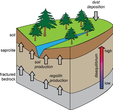
4 Geohydrology and Critical Zone Research The critical zone is the conveyor of lifesustaining nutrients and energy stored in minerals. Goal: understand the fundamental processes and how they are affected by change.
5 Geohydrology and Critical Zone Research Massive assimilation from old and new technologies North American Regional Reanalysis data Airborne geophysics data Resistivity and seismic data Ground penetrating radar Soil data Ecosystem data Isotope tracers Complex, multiscale modeling including Terrestrial Ecosystem Exchange Simulator (ecosystem scale model of surface/ subsurface water interactions) T-Soil model (water, heat, CO2 fluxes in soil-plant-atmosphere) Laramie snow model (spatially distributed, model for watershed scale water yield estimation) ParFlow model (hydrological model for flow in complex terrain) Weather Research and Forecast (WRF) Community Land Model PIs: Anne Sylvester, Steve Holbrook, Scott Miller
6

7 Laramie snow model output Movie of snow water equivalent in A Snowy Range basin over a year. Noriaki Ohara


8 Water & the West Goal: develop a high resolution, large watershed model enabled by NWSC, yet accessible to policy makers
9 Models will help answer questions like: - What are the potential impacts of climate change on the longterm yield of water from the upper Colorado River basin? - How will future land-use changes due to development and natural causes such as fire, pine bark beetle affect water supplies? - What are the effects of trans-basin diversions and increases water consumptive use on the water storage in Lake Powell in years? PIs: Craig Douglas, Fred Ogden

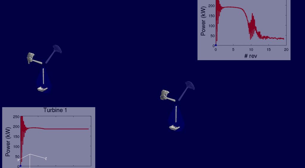
10 Modeling wind farms Goals: better understand low-level wind, and provide tools to better design efficient wind farms that account for local weather patterns and geography. PIs: Dimitri Mavriplis, Jay Sitaraman Computationally intensive: 2 rev/day on 256 cores with at least 80 revs needed.
11
 Wind speed contours D C")
12 FLOWYO simulation (steady wind flow) Wind speed contours D C B
 Wind speed contours D")
13 FLOWYO simulation (turbulent inflow) Wind speed contours D C B

14 This project transforms seismic hazard analysis into a physics-based science by assimilating seismic waveform observations from past earthquakes to systematically improve earth structure and earthquake source models. Problems with current Earthquake knowledge: Existing seismic maps are focused around the faults; yet these may not be the most dangerous areas. Relies too much upon actual earthquakes to extract geological information. PI: Po Chen


15 Shear wave speed in subsurface Old algorithm With new algorithm 5 km 2 km Study requires ~60 million core hours

16 Motivating questions: Regional Climate modeling Can the Weather Research and Forecast (WRF) model reproduce the fine-scale spatial patterns of seasonal precipitation and runoff over the complex terrain in the western part of the North-Central region over a decade-long period? Based on the WRF model what is the expected precipitation and runoff in the North-Central region by mid-century? PI: Bart Geerts

17 Regional Climate modeling Motivating question: Can one model the effects of cloud seeding in the Snowy Range mountains, in order to have seeding be more effective/economical? PI: Bart Geerts Outcomes: The modeled storm vertical motion over the mountain reveals a turbulent boundary layer and gravity waves above the boundary layer, similar to observed. But model does not show this positive seeding effect because the rapid decrease in storm intensity overwhelmed the seeding signal.

18 Idea: Can we entomb carbon dioxide to reduce amount of greenhouse gas dispersed into the atmosphere? Question: How do we model this so that we can evaluate economic feasibility, safety? Difficulties: heterogeneity, multi-physics and time scales. PIs: Felipe Pereira and Ye Zhang


19 Education, Outreach and Training Goals Integrate Research & Education Build cyberinfrastructure and computational science in the region Train the next generation of computer scientists Enhance programs at community colleges Broaden participation Improve K-12 Computational Thinking Broaden diversity Engage the public

20
Filling Gaps in Water Supply Predictions: The RIO-SNO-FLOW Project
 Filling Gaps in Water Supply Predictions: The RIO-SNO-FLOW Project Project Team: Colorado Water Conservation Board NOAA National Severe Storms Laboratory (NSSL) National Center for Atmospheric Research
Developing a High-Resolution Texas Water and Climate Prediction Model
 Developing a High-Resolution Texas Water and Climate Prediction Model Zong-Liang Yang (512) 471-3824 liang@jsg.utexas.edu Water Forum II on Texas Drought and Beyond, Austin, Texas, 22-23 October, 2012
Arizona Cloud Seeding Efforts: A Salt River Project Perspective. James Walter SRP Surface Water Resources CPWAC/CPWP Joint Meeting March 30, 2018
 Arizona Cloud Seeding Efforts: A Salt River Project Perspective James Walter SRP Surface Water Resources Importance of Winter Precipitation Winter Cloud Seeding 101 Early Cloud Seeding Projects Questions
WyCEHG: Linking surface hydrology and groundwater through near-surface geophysics
 Wyoming Center for Environmental Hydrology and Geophysics WyCEHG: Linking surface hydrology and groundwater through near-surface geophysics Scott Miller WIG Meeting Oct. 30, 2017 Wyoming Center for Environmental
CLIMATE MODEL DOWNSCALING: HOW DOES IT WORK AND WHAT DOES IT TELL YOU?
 rhgfdjhngngfmhgmghmghjmghfmf CLIMATE MODEL DOWNSCALING: HOW DOES IT WORK AND WHAT DOES IT TELL YOU? YAN FENG, PH.D. Atmospheric and Climate Scientist Environmental Sciences Division Argonne National Laboratory
THE CANADIAN CENTRE FOR CLIMATE MODELLING AND ANALYSIS
 THE CANADIAN CENTRE FOR CLIMATE MODELLING AND ANALYSIS As Canada s climate changes, and weather patterns shift, Canadian climate models provide guidance in an uncertain future. CANADA S CLIMATE IS CHANGING
Climate Change or Climate Variability?
 Climate Change or Climate Variability? Key Concepts: Greenhouse Gas Climate Climate change Climate variability Climate zones Precipitation Temperature Water cycle Weather WHAT YOU WILL LEARN 1. You will
Observed State of the Global Climate
 WMO Observed State of the Global Climate Jerry Lengoasa WMO June 2013 WMO Observations of Changes of the physical state of the climate ESSENTIAL CLIMATE VARIABLES OCEANIC ATMOSPHERIC TERRESTRIAL Surface
The known requirements for Arctic climate services
 The known requirements for Arctic climate services based on findings described in STT White paper 8/2015 Johanna Ekman / EC PHORS STT Regional drivers The Arctic region is home to almost four million people
Dual-Frequency Ku- Band Radar Mission Concept for Snow Mass
 Dual-Frequency Ku- Band Radar Mission Concept for Snow Mass Chris Derksen Environment and Climate Change Canada Study Team: Climate Research Division/Meteorological Research Division, ECCC Canadian Space
Graduate Courses Meteorology / Atmospheric Science UNC Charlotte
 Graduate Courses Meteorology / Atmospheric Science UNC Charlotte In order to inform prospective M.S. Earth Science students as to what graduate-level courses are offered across the broad disciplines of
Evaluation of Winter Weather in Wyoming based on Numerical Weather Modeling for Snow Fence System Design
 Evaluation of Winter Weather in Wyoming based on Numerical Weather Modeling for Snow Fence System Design Noriaki Ohara University of Wyoming Low visibility due to blowing snow amplified the scale of the
New A-Level Physical Geography
 Half Term 1 3.1 Physical Geography: 3.1.5 Hazards: Plate Tectonics This optional section of our specification focuses on the lithosphere and the atmosphere, which intermittently but regularly present natural
Modeling the Arctic Climate System
 Modeling the Arctic Climate System General model types Single-column models: Processes in a single column Land Surface Models (LSMs): Interactions between the land surface, atmosphere and underlying surface
EARTH AND SPACE SCIENCE
 EARTH AND SPACE SCIENCE Content Domain Range of Competencies l. Nature of Science 0001 0003 18% ll. Geology 0004 0007 25% lll. IV. Oceanography and Freshwater Systems 0008 0010 19% The Atmosphere, Weather,
Land Surface Processes and Their Impact in Weather Forecasting
 Land Surface Processes and Their Impact in Weather Forecasting Andrea Hahmann NCAR/RAL with thanks to P. Dirmeyer (COLA) and R. Koster (NASA/GSFC) Forecasters Conference Summer 2005 Andrea Hahmann ATEC
WWA Summer Tour. Tuesday, June 20, Lander, Wyoming. Contents. Final Water Forum for Snowcover & Stream flow Generation
 Issue Sixty Five, Volume Two 2017 WWA Officers WWA Summer Tour Tuesday, June 20, 2017 Lander, Wyoming Tour highlights include: Worthen Meadows. Sinks Canyon, Popo Agie River Restoration project, Popo Agie
The U.S. National Integrated Drought Information System. Roger S. Pulwarty National Oceanic and Atmospheric Administration USA
 The U.S. National Integrated Drought Information System Roger S. Pulwarty National Oceanic and Atmospheric Administration USA Drought: Weather-climate continuum and adaptation deficits 2010 2011 2012 2015
NIDIS Intermountain West Regional Drought Early Warning System February 7, 2017
 NIDIS Drought and Water Assessment NIDIS Intermountain West Regional Drought Early Warning System February 7, 2017 Precipitation The images above use daily precipitation statistics from NWS COOP, CoCoRaHS,
What is the IPCC? Intergovernmental Panel on Climate Change
 IPCC WG1 FAQ What is the IPCC? Intergovernmental Panel on Climate Change The IPCC is a scientific intergovernmental body set up by the World Meteorological Organization (WMO) and by the United Nations
Striving Sufficient Lead Time of Flood Forecasts via Integrated Hydro-meteorological Intelligence
 Striving Sufficient Lead Time of Flood Forecasts via Integrated Hydro-meteorological Intelligence Dong-Sin Shih Assistant Professor, National Chung Hsing University, Taiwan, Sep. 6, 2013 Outlines Introductions
Directed Reading. Section: Types of Maps
 Skills Worksheet Directed Reading Section: Types of Maps 1. What are some of the characteristics of an area shown on maps used by Earth scientists? a. types of animals, types of plants, types of minerals
How Will the Colorado Run? The Colorado River in a Warmer World
 How Will the Colorado Run? The Colorado River in a Warmer World The Future of the Colorado River October 13, 2018 Brad Udall Senior Scientist/Scholar Colorado State University Bradley.Udall@colostate.edu
NIDIS Intermountain West Drought Early Warning System April 18, 2017
 1 of 11 4/18/2017 3:42 PM Precipitation NIDIS Intermountain West Drought Early Warning System April 18, 2017 The images above use daily precipitation statistics from NWS COOP, CoCoRaHS, and CoAgMet stations.
Subject Classification
 Istituto Nazionale di Geofisica e Vulcanologia earth-prints home page roma library bologna library catania library milano library napoli library palerm Subject Classification Earth-prints organize its
COURSE OUTLINE. GEO 101 Geography 3 Course Number Course Title Credits. Reference Liberal Arts Division Book List
 MERCER COUNTY COMMUNITY COLLEGE LIBERAL ARTS DIVISION COURSE OUTLINE GEO 101 Geography 3 Course Number Course Title Credits Required Materials: Catalog Description: Reference Liberal Arts Division Book
Missouri Educator Gateway Assessments
 Missouri Educator Gateway Assessments FIELD 019: EARTH SCIENCE June 2014 Content Domain Range of Competencies Approximate Percentage of Test Score I. Science and Engineering Practices 0001 0003 18% II.
4840 South State Rd Cell:
 DR. REBECCA A. BOLINGER NOAA GLERL Work: 734-741- 2248 4840 South State Rd Cell: 850-766- 6520 Ann Arbor, MI 48108 becky.bolinger@noaa.gov RESEARCH INTERESTS Hydroclimate variability, hydrologic cycle,
NCAR UCAR. 50 th Anniversary Lecture
 NCAR & UCAR 50 th Anniversary Lecture Turbulence, Wind Shear, Toxin Attacks, and Other Things That Go Bump In the Night: Applied Research for Real-Life Problems Bill Mahoney National Center for Atmospheric
Pee Dee Explorer. Science Standards
 Science Standards About Pee Dee Explorer What does it mean when someone says they are from the "Pee Dee" of South Carolina? A place is bigger than its physical geography. A "sense of place" weaves together
Grade 8 Learning Objectives MS-PS2-4.
 MS-PS2-4. Construct and present arguments using evidence to support the claim that gravitational interactions are attractive and depend on the masses of interacting objects. [Clarification Statement: Examples
ENVIRONMENTAL GEOSCIENCE UNIFORM SYLLABUS
 ENVIRONMENTAL GEOSCIENCE UNIFORM SYLLABUS The Association of Professional Engineers and Geoscientists of the Province of British Columbia Note: 1. This Syllabus May Be Subject To Change 2. These Courses
Idaho Power Company s Cloud Seeding Program May 6, 2016
 Idaho Power Company s Cloud Seeding Program May 6, 2016 Shaun Parkinson, PhD, P.E. Overview What is cloud seeding & how is it done Idaho Power s history with cloud seeding Idaho Power s cloud seeding projects
NIDIS Intermountain West Drought Early Warning System December 11, 2018
 NIDIS Drought and Water Assessment NIDIS Intermountain West Drought Early Warning System December 11, 2018 Precipitation The images above use daily precipitation statistics from NWS COOP, CoCoRaHS, and
Earth Science. Explain how Earth's biogeochemical cycles create a balance of materials. Examine the importance of biogeochemical cycles.
 Unit 1: DYNAMIC STRUCTURE OF EARTH Introduction to Understand that earth science is based upon the four sciences of astronomy, geology, meteorology, and oceanography. Identify topics studied within the
Susquehanna River Basin A Research Community Hydrologic Observatory. NSF-Funded Infrastructure Proposal in Support of River Basin Hydrologic Sciences
 Susquehanna River Basin A Research Community Hydrologic Observatory NSF-Funded Infrastructure Proposal in Support of River Basin Hydrologic Sciences Fundamental Problem: How Do Humans and Climate Impact
Reservoir Operations (FBO) (FIRO)
 (FIRO)") A Methodology for Adaptive Water Management Forecast-Based Forecast-Informed Operations Reservoir Operations (FBO) (FIRO) Mike McMahon Senior Hydro-Meteorologist/Climate Science/Resiliency Lead - HDR Engineering
A Methodology for Adaptive Water Management Forecast-Based Forecast-Informed Operations Reservoir Operations (FBO) (FIRO) Mike McMahon Senior Hydro-Meteorologist/Climate Science/Resiliency Lead - HDR Engineering
Improved Precipitation Measurement in Wintertime Snowstorms. Focus Category: WQN, CP, HYDROL. Keywords: Snow Process Research.
 Improved Precipitation Measurement in Wintertime Snowstorms Focus Category: WQN, CP, HYDROL Keywords: Snow Process Research Final Report Start Date: 03/01/2011 End Date: 02/28/2013 Principal Investigator:
5. General Circulation Models
 5. General Circulation Models I. 3-D Climate Models (General Circulation Models) To include the full three-dimensional aspect of climate, including the calculation of the dynamical transports, requires
Weather and Climate Prediction ATM S 380
 Weather and Climate Prediction ATM S 380 Course web site http://www.atmos.washington.edu/academics/classes/2011q1/380/ Instructor: Professor Cecilia Bitz, PhD in UW atmospheric sciences 1997 Lecture notes
3. Recognize that when a science investigation is replicated, very similar results are expected.
 STANDARD 5.1 SCIENTIFIC PROCESSES ALL STUDENTS WILL DEVELOP PROBLEM-SOLVING, DECISION-MAKING AND INQUIRY SKILLS, REFLECTED BY FORMULATING USABLE QUESTIONS AND HYPOTHESES, PLANNING EXPERIMENTS, CONDUCTING
This image cannot currently be displayed. Course Catalog. Earth Science Glynlyon, Inc.
 This image cannot currently be displayed. Course Catalog Earth Science 2016 Glynlyon, Inc. Table of Contents COURSE OVERVIEW... 1 UNIT 1: DYNAMIC STRUCTURE OF EARTH... 1 UNIT 2: FORCES AND FEATURES OF
Canadian Geography Final Exam Review (September to Mid-term Exam)
") Canadian Geography 1202 - Final Exam Review (September to Mid-term Exam) Glossary Terms: Some of the following terms may be covered in the questions that follow. System Natural System Ecosystem Human System
Canadian Geography 1202 - Final Exam Review (September to Mid-term Exam) Glossary Terms: Some of the following terms may be covered in the questions that follow. System Natural System Ecosystem Human System
DK DM M EMORANDUM D ECEMBER 28, 2018 SUBJECT:
 TO: CC: FROM: SUBJECT: BOARD OF DIRECTORS M EMORANDUM D ECEMBER 28, 2018 ANDY MUELLER, GENERAL MANAGER DAVE DK KANZER, P.E. & DON MEYER, P.E. DK DM COLORADO RIVER BASIN WATER SUPPLY CONDITIONS UPDATE AND
Mountain Snowpacks, Climate Change and the Silver Solution
 Mountain Snowpacks, Climate Change and the Silver Solution Climate Change Seminar Series University of Nevada Las Vegas 11 July 2012 Arlen Huggins Desert Research Institute Reno, Nevada Climate, snow and
Unit 2: The World in Spatial Terms (Lessons 6-7)
") Unit 2: The World in Spatial Terms (Lessons 6-7) Physical Features of Earth Create Challenges and Opportunities The physical features of Earth create both challenges and opportunities for the people living
Unit 2: The World in Spatial Terms (Lessons 6-7) Physical Features of Earth Create Challenges and Opportunities The physical features of Earth create both challenges and opportunities for the people living
Curriculum Catalog
 2017-2018 Curriculum Catalog 2017 Glynlyon, Inc. Table of Contents EARTH SCIENCE COURSE OVERVIEW...1 UNIT 1: DYNAMIC STRUCTURE OF EARTH... 1 UNIT 2: FORCES AND FEATURES OF EARTH... 1 UNIT 3: FEATURES OF
NOAA s National Weather Service
 NOAA s National Weather Service Colorado Basin River Forecast Center Developing Climate-Informed Ensemble Streamflow Forecasts over the Colorado River Basin W. Paul Miller Colorado Basin River Forecast
ATMOSPHERIC CIRCULATION AND WIND
 ATMOSPHERIC CIRCULATION AND WIND The source of water for precipitation is the moisture laden air masses that circulate through the atmosphere. Atmospheric circulation is affected by the location on the
Novel Snotel Data Uses: Detecting Change in Snowpack Development Controls, and Remote Basin Snow Depth Modeling
 Novel Snotel Data Uses: Detecting Change in Snowpack Development Controls, and Remote Basin Snow Depth Modeling OVERVIEW Mark Losleben and Tyler Erickson INSTAAR, University of Colorado Mountain Research
March 1, 2003 Western Snowpack Conditions and Water Supply Forecasts
 Natural Resources Conservation Service National Water and Climate Center 101 SW Main Street, Suite 1600 Portland, OR 97204-3224 Date: March 17, 2003 Subject: March 1, 2003 Western Snowpack Conditions and
WSWC/NOAA Workshops on S2S Precipitation Forecasting
 WSWC/NOAA Workshops on S2S Precipitation Forecasting San Diego, May 2015 Salt Lake City at NWS Western Region HQ, October 2015 Las Vegas at Colorado River Water Users Association, December 2015 College
Science Colorado Sample Graduation Competencies and Evidence Outcomes
 Science Colorado Sample Graduation Competencies and Evidence Outcomes Science Graduation Competency 1 Physical Science Students know and understand common properties, forms, and changes in matter and energy.
Regional climate modelling in the future. Ralf Döscher, SMHI, Sweden
 Regional climate modelling in the future Ralf Döscher, SMHI, Sweden The chain Global H E H E C ( m 3/s ) Regional downscaling 120 adam 3 C HAM 4 adam 3 C HAM 4 trl A2 A2 B2 B2 80 40 0 J F M A M J J A S
Quenching the Valley s thirst: The connection between Sierra Nevada snowpack & regional water supply
 Quenching the Valley s thirst: The connection between Sierra Nevada snowpack & regional water supply Roger Bales, UC Merced Snow conditions Snow & climate change Research directions Sierra Nevada snow
RAL Advances in Land Surface Modeling Part I. Andrea Hahmann
 RAL Advances in Land Surface Modeling Part I Andrea Hahmann Outline The ATEC real-time high-resolution land data assimilation (HRLDAS) system - Fei Chen, Kevin Manning, and Yubao Liu (RAL) The fine-mesh
ON LINE ARCHIVE OF STORM PENETRATING DATA
 ON LINE ARCHIVE OF STORM PENETRATING DATA Matthew Beals, Donna V. Kliche, and Andrew G. Detwiler Institute of Atmospheric Sciences, South Dakota School of Mines and Technology, Rapid City, SD Steve Williams
Model resolution impact on Precipitation: Comparison to SNOTEL observations
 Model resolution impact on Precipitation: Comparison to SNOTEL observations 5/7/2012 40 proj. updates Sensitivity to model grid resolution: Precipitation from the 8-year Current Climate Simulation Percent
NIDIS Intermountain West Drought Early Warning System April 16, 2019
 NIDIS Intermountain West Drought Early Warning System April 16, 2019 Precipitation The images above use daily precipitation statistics from NWS COOP, CoCoRaHS, and CoAgMet stations. From top to bottom,
CURRICULUM CATALOG EARTH/ENVIRONMENTAL SCIENCE (35012X0) NC
 NC") 2018-19 CURRICULUM CATALOG EARTH/ENVIRONMENTAL SCIENCE (35012X0) NC Table of Contents EARTH/ENVIRONMENTAL SCIENCE (35012X0) NC COURSE OVERVIEW... 2 UNIT 1: ORIGIN OF THE EARTH... 2 UNIT 2: HISTORY OF EARTH...
2018-19 CURRICULUM CATALOG EARTH/ENVIRONMENTAL SCIENCE (35012X0) NC Table of Contents EARTH/ENVIRONMENTAL SCIENCE (35012X0) NC COURSE OVERVIEW... 2 UNIT 1: ORIGIN OF THE EARTH... 2 UNIT 2: HISTORY OF EARTH...
NOAA Hurricane Forecast Improvement Project
 NOAA Hurricane Forecast Improvement Project Fred Toepfer Hurricane Forecast Improvement Project Manager November 9 th, 2009 Outline NOAA Hurricane Forecast Improvement Project Driving Issue Purpose NOAA
6 th Grade Science Curriculum
 6 th Grade Science Curriculum Each 6 th grade science student in Dunlap District 323 continues to develop their understanding of scientific and engineering practices and content by examining the discipline
Section 1: The Geosphere
 Section 1: The Geosphere Preview Classroom Catalyst Objectives The Earth as a System Discovering Earth s Interior The Composition of the Earth The Structure of the Earth Plate Tectonics Section 1: The
Physical Geography: Patterns, Processes, and Interactions, Grade 11, University/College Expectations
 Geographic Foundations: Space and Systems SSV.01 explain major theories of the origin and internal structure of the earth; Page 1 SSV.02 demonstrate an understanding of the principal features of the earth
Using a high-resolution ensemble modeling method to inform risk-based decision-making at Taylor Park Dam, Colorado
 Using a high-resolution ensemble modeling method to inform risk-based decision-making at Taylor Park Dam, Colorado Michael J. Mueller 1, Kelly Mahoney 2, Kathleen Holman 3, David Gochis 4 1 Cooperative
NIDIS Intermountain West Drought Early Warning System November 14, 2017
 NIDIS Intermountain West Drought Early Warning System November 14, 2017 Precipitation The images above use daily precipitation statistics from NWS COOP, CoCoRaHS, and CoAgMet stations. From top to bottom,
Predicting western US snowfall and runoff before the winter begins: a prospectus
 Predicting western US snowfall and runoff before the winter begins: a prospectus Tom Hamill 1, Sarah Kapnick 2, Dave DeWitt 3, Brian Gross 4, John Lhotak 5 1 NOAA/OAR Earth System Research Lab, Physical
Overview of Geoscience Employers Workshop Outcomes
 Overview of Geoscience Employers Workshop Outcomes General thoughts on concepts: From Geoscience Employers Workshop Systems Thinking How systems work and interact Processes Atmosphere: Climate, Weather,
Meteorological instruments and observations methods: a key component of the Global Earth Observing System of Systems (GEOSS)
") GLOBAL OBSERVING SYSTEMS Instruments and Methods of Observation Programme Meteorological instruments and observations methods: a key component of the Global Earth Observing System of Systems (GEOSS) Dr.
GLOBAL OBSERVING SYSTEMS Instruments and Methods of Observation Programme Meteorological instruments and observations methods: a key component of the Global Earth Observing System of Systems (GEOSS) Dr.
AS Atmospheric Sciences Orals and PICOs Monday, 08 April
 AS Atmospheric Sciences Orals and PICOs Monday, 08 April MO1, 08:30 10:00 MO2, 10:30 12:00 MOL, 12:15 13:15 MO3, 13:30 15:00 AS1.1, Numerical weather prediction, data assimilation and ensemble forecasting,
Doug Kluck NOAA Kansas City, MO National Center for Environmental Information (NCEI) National Integrated Drought Information System (NIDIS)
 National Integrated Drought Information System (NIDIS)") National Integrated Drought Information System (NIDIS) for the Missouri River Basin Drought Early Warning Information System (DEWS) & Runoff Trends in the Missouri Basin & Latest Flood Outlook Doug Kluck
National Integrated Drought Information System (NIDIS) for the Missouri River Basin Drought Early Warning Information System (DEWS) & Runoff Trends in the Missouri Basin & Latest Flood Outlook Doug Kluck
Mesoscale meteorological models. Claire L. Vincent, Caroline Draxl and Joakim R. Nielsen
 Mesoscale meteorological models Claire L. Vincent, Caroline Draxl and Joakim R. Nielsen Outline Mesoscale and synoptic scale meteorology Meteorological models Dynamics Parametrizations and interactions
The 21 st Century Colorado River Hot Drought and Implications for the Future
 Coauthor: Jonathan Overpeck The 21 st Century Colorado River Hot Drought and Implications for the Future CRWCD State of the River May 4, 2017 Brad Udall Colorado State University Bradley.udall@colostate.edu
GEOCHEMISTRY UNIFORM SYLLABUS
 GEOCHEMISTRY UNIFORM SYLLABUS The Association of Professional Engineers and Geoscientists of the Province of British Columbia Note: 1. This Syllabus May Be Subject To Change 2. These Courses Are Required
3 rd Grade Math Earth Science
 3 rd Grade Math Earth Science 6 th Grade Earth Science Teaching & Learning Framework * Clarification statements not provided on framework Quarter 1 Quarter 2 Quarter 3 Quarter 4 Unit 1 6 weeks Rocks and
Operational Monsoon Monitoring at NCEP
 Operational Monsoon Monitoring at NCEP Wassila M. Thiaw Climate Prediction Center National Centers for Environmental Predictions Operational Monsoon Monitoring at NCEP Wassila M. Thiaw Climate Prediction
Chippewa County Natural Hazards Mitigation Plan
 2014 Chippewa County Natural Hazards Mitigation Plan Prepared for: Chippewa County Office of Emergency Management With the Assistance of: Eastern U.P. Regional Planning & Development Commission April,
Earth Systems Standards
 Earth Systems Earth Systems Standards The Cobb Teaching and Learning Standards (CT & LS) for Science are designed to provide foundational knowledge and skills for all students to develop proficiency in
Water Balance in the Murray-Darling Basin and the recent drought as modelled with WRF
 18 th World IMACS / MODSIM Congress, Cairns, Australia 13-17 July 2009 http://mssanz.org.au/modsim09 Water Balance in the Murray-Darling Basin and the recent drought as modelled with WRF Evans, J.P. Climate
Tracking the Climate Of Northern Colorado Nolan Doesken State Climatologist Colorado Climate Center Colorado State University
 Tracking the Climate Of Northern Colorado Nolan Doesken State Climatologist Colorado Climate Center Colorado State University Northern Colorado Business Innovations November 20, 2013 Loveland, Colorado
NIDIS Intermountain West Drought Early Warning System May 23, 2017
 NIDIS Drought and Water Assessment NIDIS Intermountain West Drought Early Warning System May 23, 2017 Precipitation The images above use daily precipitation statistics from NWS COOP, CoCoRaHS, and CoAgMet
S6E1. Obtain, evaluate, and communicate information about current scientific views of the universe and how those views evolved. a.
 S6E1. Obtain, evaluate, and communicate information about current scientific views of the universe and how those views evolved. a. Ask questions to determine changes in models of Earth s position in the
Geography Class XI Fundamentals of Physical Geography Section A Total Periods : 140 Total Marks : 70. Periods Topic Subject Matter Geographical Skills
 Geography Class XI Fundamentals of Physical Geography Section A Total Periods : 140 Total Marks : 70 Sr. No. 01 Periods Topic Subject Matter Geographical Skills Nature and Scope Definition, nature, i)
NIDIS Intermountain West Drought Early Warning System December 18, 2018
 NIDIS Intermountain West Drought Early Warning System December 18, 2018 Precipitation The images above use daily precipitation statistics from NWS COOP, CoCoRaHS, and CoAgMet stations. From top to bottom,
Threats to the Power System
 Threats to the Power System Energy Risk and Critical Infrastructure Workshop National Conference of State Legislatures William P. Mahoney III Deputy Director, Research Applications Laboratory National
NATS 101 Section 13: Lecture 25. Weather Forecasting Part II
 NATS 101 Section 13: Lecture 25 Weather Forecasting Part II NWP s First Baby Steps: Mid-Twentieth Century It wasn t until the development of computers in the 1940s and 1950s that NWP could be even attempted.
ASO in Colorado: supporting resilient water management through research support & emerging partnerships
 ASO in Colorado: supporting resilient water management through research support & emerging partnerships Jeffrey S. Deems Airborne Snow Observatory Western Water Assessment National Snow and Ice Data Center
Unit 4. Unit 8 3 weeks Solar Sys. & Universe Earth and Moon
 6 th Grade Science 6 th Grade Earth Science Teaching & Learning Framework * Clarification statements not provided on framework Quarter 1 Quarter 2 Quarter 3 Quarter 4 Unit 1 Unit 2 4 weeks Unit 3 Unit
NSF Expeditions in Computing. Understanding Climate Change: A Data Driven Approach. Vipin Kumar University of Minnesota
 NSF Expeditions in Computing Understanding Climate Change: A Data Driven Approach Vipin Kumar University of Minnesota kumar@cs.umn.edu www.cs.umn.edu/~kumar Vipin Kumar UCC Aug 15, 2011 Climate Change:
CLIMATE CHANGE DATA PROJECTIONS FOR ONTARIO AND THE GREAT LAKES BASIN
 CLIMATE CHANGE DATA PROJECTIONS FOR ONTARIO AND THE GREAT LAKES BASIN ECO Climate Data Roundtable, January 8, 2014 Richard Peltier, Physics, U Toronto Regional Data Sets of Climate Change Projections 2
Added Value of Convection Resolving Climate Simulations (CRCS)
") Added Value of Convection Resolving Climate Simulations (CRCS) Prein Andreas, Gobiet Andreas, Katrin Lisa Kapper, Martin Suklitsch, Nauman Khurshid Awan, Heimo Truhetz Wegener Center for Climate and Global
Added Value of Convection Resolving Climate Simulations (CRCS) Prein Andreas, Gobiet Andreas, Katrin Lisa Kapper, Martin Suklitsch, Nauman Khurshid Awan, Heimo Truhetz Wegener Center for Climate and Global
Colorado River Management under Uncertainty
 Colorado River Management under Uncertainty Terry Fulp Deputy Regional Director Lower Colorado Region WRRC Annual Meeting June 24, 2008 Colorado River Management under Uncertainty Overview of Colorado
Imaging Critical Zone Processes
 Imaging Critical Zone Processes Kamini Singha Hydrologic Science and Engineering Colorado School of Mines With contributions from: Xavier Comas, Jorden Hayes, and Andy Parsekian Key critical zone processes
NCAR Unified Community Atmosphere Modeling Roadmap
 (Project) NCAR Unified Community Atmosphere Modeling Roadmap Andrew Gettelman, Bill Skamarock, Mary Barth, Jean-François Lamarque On behalf of the Singletrack Steering Group (Also a mountain biking Magazine:
TEACHER CERTIFICATION STUDY GUIDE FOUNDATIONS OF SCIENTIFIC INQUIRY
 Table of Contents SUBAREA I. COMPETENCY 1.0 FOUNDATIONS OF SCIENTIFIC INQUIRY UNDERSTAND THE GENERAL RELATIONSHIPS AND COMMON THEMES THAT CONNECT MATHEMATICS, SCIENCE, AND TECHNOLOGY...1 SKILL 1.1 SKILL
Arctic System Reanalysis *
 Arctic System Reanalysis * David H. Bromwich 1,2, Keith M. Hines 1 and Le-Sheng Bai 1 1 Polar Meteorology Group, Byrd Polar Research Center 2 Atmospheric Sciences Program, Dept. of Geography The Ohio State
Analyzing/Forecasting Weather
 Analyzing/Forecasting Weather Focus Question Dude Its wind. It blows everywhere. Meteorologist to Nicholas Cage in The Weatherman VA SOL SOL 3 The student will investigate and understand how to read and
Climate 1: The Climate System
 Climate 1: The Climate System Prof. Franco Prodi Institute of Atmospheric Sciences and Climate National Research Council Via P. Gobetti, 101 40129 BOLOGNA SIF, School of Energy, Varenna, July 2014 CLIMATE
SNOW AND GLACIER HYDROLOGY
 SNOW AND GLACIER HYDROLOGY by PRATAP SINGH National Institute of Hydrology, Roorkee, India and VIJAY P. SINGH Department of Civil and Environmental Engineering, Louisiana State University, Baton Rouge,
Northern New England Climate: Past, Present, and Future. Basic Concepts
 Northern New England Climate: Past, Present, and Future Basic Concepts Weather instantaneous or synoptic measurements Climate time / space average Weather - the state of the air and atmosphere at a particular