Imaging Critical Zone Processes
|
|
|
- Timothy Richard
- 5 years ago
- Views:
Transcription
1 Imaging Critical Zone Processes Kamini Singha Hydrologic Science and Engineering Colorado School of Mines With contributions from: Xavier Comas, Jorden Hayes, and Andy Parsekian


2 Key critical zone processes 1. Delivery of water/energy to the subsurface 2. Transformation of rock into soil 3. Links between vegetation and hydrology 4. Controls on terrestrial carbon 5. Changes in CZ services with disturbance [Sullivan et al., 2017, New Opportunities for Critical Zone Science] Atmosphere Biota Soil Water Rock [Chorover et al., 2007, Elements]


![, 2015, Science] Little difference in regolith](/docs-images/88/116259024/images/3-3.jpg "thickness with slope aspect [Befus et al.")
3 Geophysical observations provide a macroscope into subsurface Minimally: a better way to interpolate Better: a way to explore CZ controls, processes N [St. Clair et al., 2015, Science] Little difference in regolith thickness with slope aspect [Befus et al., 2011, VZJ] Thicker regolith on N- facing slopes

4 A lot has happened since 2015
5 What CZ scientists would like Macroscopic distributions of: Porosity Bulk density Chemical/mineralogical composition Mineral surface area Root distributions Subsurface connectivity
6 Key critical zone processes 1. Delivery of water/energy to the subsurface 2. Transformation of rock into soil 3. Links between vegetation and hydrology 4. Controls on terrestrial carbon 5. Changes in CZ services with disturbance [Sullivan et al., 2017, New Opportunities for Critical Zone Science] Atmosphere Biota Soil Water Rock [Chorover et al., 2007, Elements]
7 depth Initial volume wetness q i q saturated transmission zone wetting front 1) Delivery of water into the subsurface* Controls a variety of ecosystem services Moisture is generally an easy geophysical target D electrical resistivity D dielectric permittivity D seismic velocity *more from Sander Huisman soon

8 Moving beyond simple conservative tracers [Wehrer et al., 2016, WRR]


9 Importance of the right rock physics relations Water content ECa from EMI Porosity [Altdorff et al., 2017, EES]

10 What are controls on water movement through a hillslope? Seismic ER Interpretation MR: mobile regolith WB: weathered bedrock B: bedrock [Thayer et al., 2018, WRR]

11 Water tracks in the Arctic

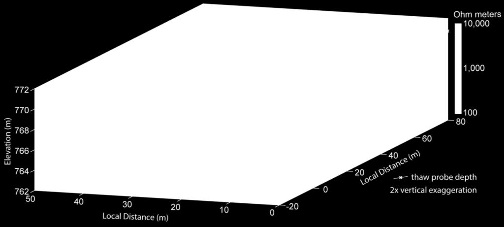
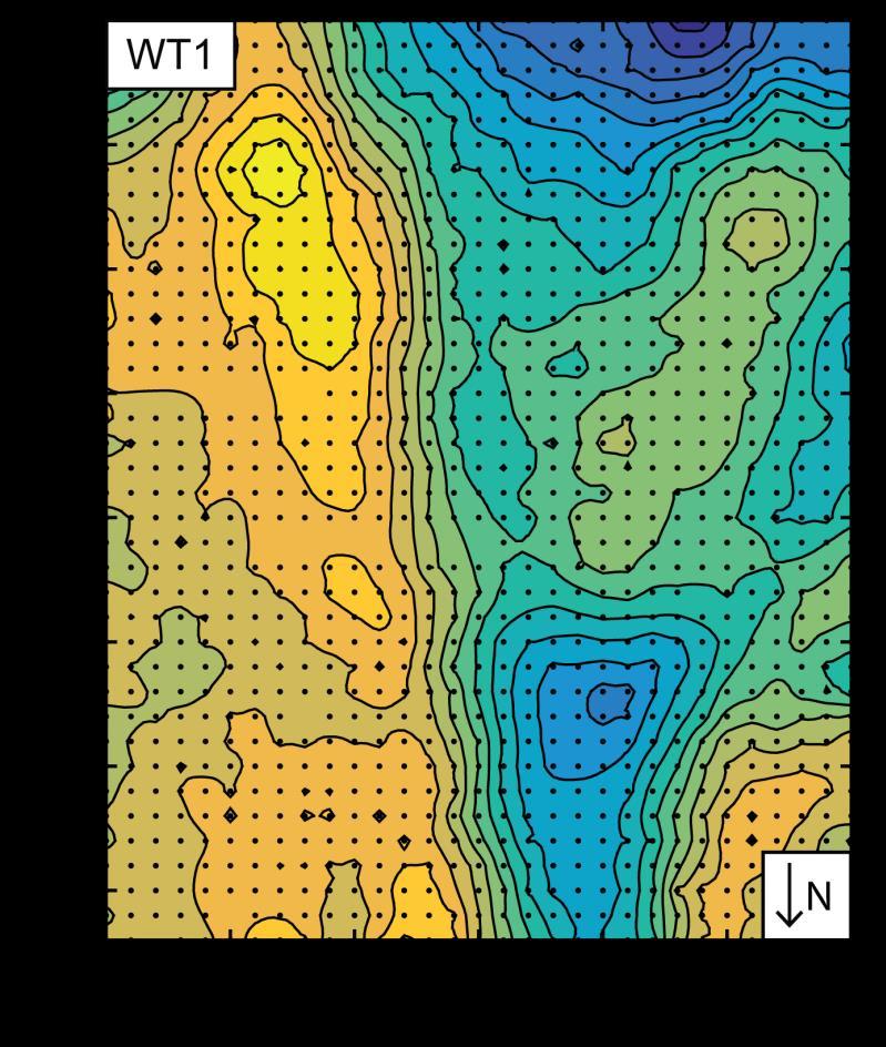
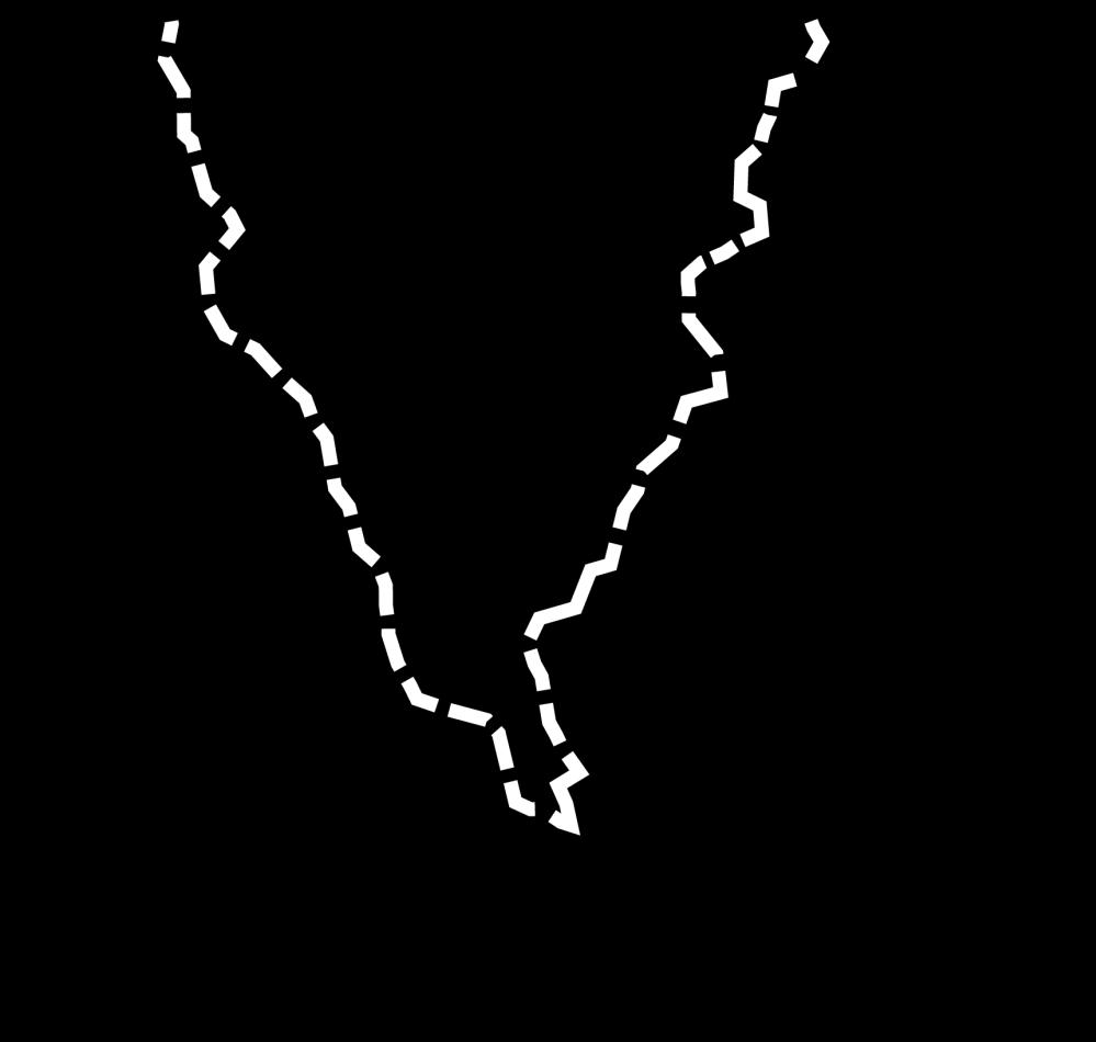
12 Mapping flowpaths in permafrost [Voytek et al., 2016, Geophysics]
13 Issues to think about Testing conceptual models of hydrologic, geochemical processes Imaging seasonally changing flow paths Developing rock physics relations between geophysics and other key properties

14 Depth 2) Transformation of rock into soil soil regolith vs. saprolite bedrock Weathering of rock at the bedrock-saprolite interface is key to critical zone processes Weathered material: prone to landslides, impacting landscape evolution; provides the medium for plant growth A good geophysical target


15 How does weathering vary over a landscape? valley ridge density ~300 m broken up intact [Hayes et al., in prep]


16 Seismic anisotropy & fracturing Soil layer is isotropic; ~500 m/s on N- and S- facing hillslopes North-facing South-facing North-facing regolith: less pronounced anisotropy velocities from ~ m/s South-facing regolith: more pronounced anisotropy velocities from ~ m/s [Pommer et al., in prep]


17 Fracture orientation is similar on both aspects North-facing South-facing No. boreholes 2 5 Total fractures Mean strike/dip of significant clusters 282 o /52 o N 054 o /40 o S 283 o /51 o N [Pommer et al., in prep]


18 Importance of foliation S- facing slopes are more deeply weathered, is this because of foliation alignment with topography? Fault? Distance, m [Pommer et al., in prep] Velocity (m/s)


19 Chemical vs. physical weathering A B C Mass loss can t describe porosity; strain can Estimate porosity from seismic refraction velocities; transform to strain [Hayes et al., in review, Science Advances]
20 Issues to think about How to parse physical and chemical weathering? What are the controls of regional stress, freeze-thaw processes, physical and chemical heterogeneity on the measured weathering signal? Trees!


21 3) Links between vegetation Geophysics has primarily been used to explore changing moisture content What are sensitivities to biogeochemical changes? and hydrology


22 Regolith under trees Tree roots add complexity Large contrast in resistivity under living trees disappears when they die under tree under stump pit-and-mound [Pawlik & Kasprzak, 2018, Geomorphology]
23 Early work on rooting depths Time-lapse ER for soil moisture dynamics reveals rooting depth differences of forest and grassland. May 10m 50m Volumetric moisture August [Jayawickreme et al., 2008, GRL] Data enabled improved root parameterization in global climate and landscape hydrology models.

24 Imaging hydraulic redistribution trees soil borings [Robinson et al., 2012, JoH]
25 Can the subsurface be linked to in-tree water use? [Mares et al., 2016, JoH]


26 Can we predict connections through time? Measured Modeled [Voytek et al., in revision, HP]
27 Issues to think about What is the geophysical signature of root behavior, associated fungi? How species dependent are results? How do we scale plant-plot measurements up to watersheds? Can we image the wood wide web? How do we make reasonable models of large-scale hydrology that incorporate plant physiology in meaningful ways?

28 4) Controls on terrestrial carbon Assessment of stocks needed to quantify carbon cycling, role in a changing climate Can image gases, structural constraints on carbon stores, transport [

29 Distribution of free-phase gas in peatland [Parsekian et al., 2011, JGR]


30 Prediction of C stocks in wetlands [McClellan et al., 2017, JGR-B]

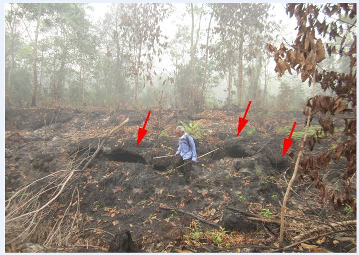

31 Burning of peats C + disturbance

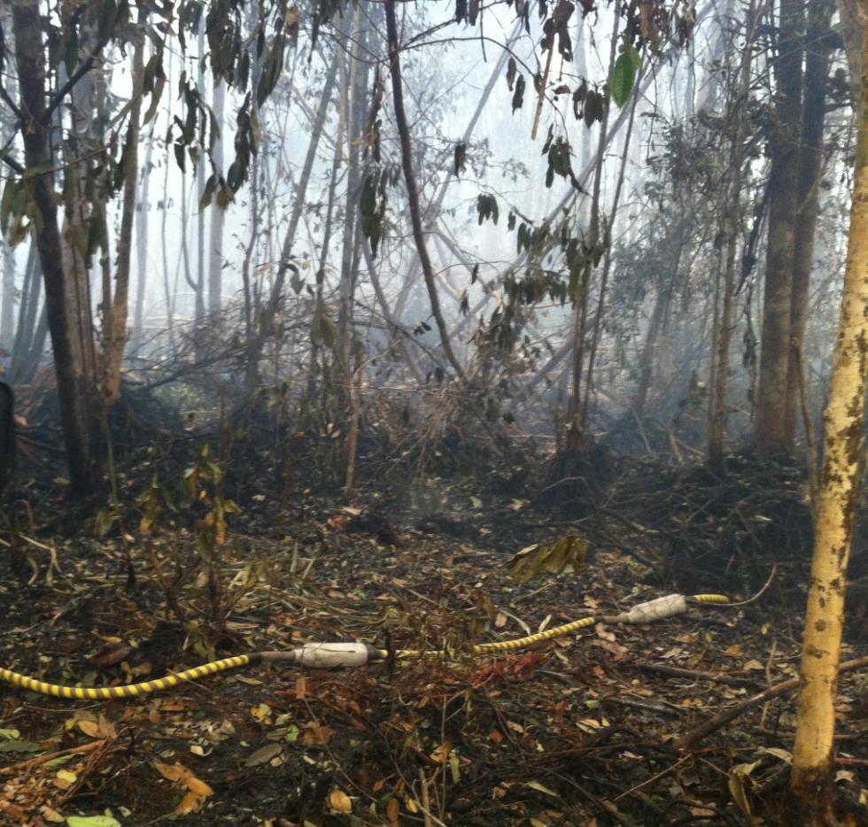
32 Marked lateral changes in EM wave velocity likely related to heterogeneities of burned peat with depth Can we infer changes in peat thickness if constrained? [Comas et al., in prep]
33 Issues to think about What observing networks are needed to make quantitative estimates of carbon cycle status, dynamics, and evolution? What information, if any, can geophysics provide on carbon fate, form or reactivity?
34 Opportunities in CZ geophysics Many open questions about how to use these data quantitatively (or even qualitatively) Methods can be used to: Test conceptual models of hydrologic processes Image large-scale geometry of geologic units, permafrost, catchment-scale geomorphic events Needs: Thinking/collaboration across disciplinary boundaries Developing rock physics relations between geophysics and physical, chemical, biological properties of interest Moving to larger scales, time lapse imaging
35 Altdorff et al., 2017, EES. Potential of catchment-wide soil water content prediction using electromagnetic induction in a forest ecosystem. Befus et al., 2011, VZJ. Seismic constraints on critical zone architecture, Boulder Creek watershed, Front Range, Colorado. Chorover et al., 2007, Elements. Soil biogeochemical processes within the critical zone. Comas et al., in prep. Using ground penetrating radar (GPR) for delineating the extent of burned peat soils in Palangkaraya, Indonesia. Harmon et al., in prep. A field- and model-based approach to reveal connections linking hillslope transpiration, groundwater fluxes, and stream flow. Hayes et al., in prep. Characterizing the distribution of fractures in the deep critical zone with geophysics and drilling. Hayes et al., in review, Science Advances. Porosity production in weathered rock: Where volumetric strain dominates over chemical mass loss. Jayawickreme et al., 2008, GRL. Subsurface imaging of vegetation, climate, and root zone moisture interactions. Mares et al., 2016, JoH. Examining diel patterns of soil and xylem moisture using electrical resistivity imaging. McClellan et al., JGR-B. Estimating belowground carbon stocks in isolated wetlands of the Northern Everglades Watershed, central Florida using ground penetrating radar and aerial imagery. Nyquist et al., 2018, VZJ. Testing the fill-and-spill model of subsurface lateral flow using ground-penetrating radar and dye tracing. Parsekian et al., 2011, JGR. Geophysical evidence for the lateral distribution of free phase gas at the peat basin scale in a large northern peatland. Pawlik & Kasprzak, 2018, Geomorphology. Regolith properties under trees and the biomechanical effects caused by tree root systems as recognized by electrical resistivity tomography. Pommer et al., in prep. An exploration of critical zone weathering on opposing montane hillslopes. Robinson et al., 2012, JoH. Evidence for spatial variability in hydraulic redistribution within an oak pine forest from resistivity imaging. St. Clair et al., 2015, Science. Geophysical imaging reveals topographic stress control of bedrock weathering. Sullivan et al., 2017, New Opportunities for Critical Zone Science, CZO White Paper. Thayer et al., 2018, WRR. Geophysical measurements to determine the hydrologic partitioning of snowmelt on a snow dominated subalpine hillslope. Wehrer et al., 2016, WRR. Characterization of reactive transport by 3-D electrical resistivity tomography (ERT) under unsaturated conditions. Whalley et al., 2017, Plant and Soil. Methods to estimate changes in soil water for phenotyping root activity in the field. Voytek et al., 2016, Geophysics. Identifying hydrologic flowpaths on arctic hillslopes using electrical resistivity and self potential. Voytek et al., in review, HP. Propagation of diel transpiration signals in the subsurface observed using the self-potential method.
Site Characterization & Hydrogeophysics
 Site Characterization & Hydrogeophysics (Source: Matthew Becker, California State University) Site Characterization Definition: quantitative description of the hydraulic, geologic, and chemical properties
Oak Ridge IFRC. Quantification of Plume-Scale Flow Architecture and Recharge Processes
 Oak Ridge IFRC Quantification of Plume-Scale Flow Architecture and Recharge Processes S. Hubbard *1, G.S. Baker *2, D. Watson *3, D. Gaines *3, J. Chen *1, M. Kowalsky *1, E. Gasperikova *1, B. Spalding
Surface Processes Focus on Mass Wasting (Chapter 10)
") Surface Processes Focus on Mass Wasting (Chapter 10) 1. What is the distinction between weathering, mass wasting, and erosion? 2. What is the controlling force in mass wasting? What force provides resistance?
Surface Processes Focus on Mass Wasting (Chapter 10) 1. What is the distinction between weathering, mass wasting, and erosion? 2. What is the controlling force in mass wasting? What force provides resistance?
Department of Geosciences, Florida Atlantic University, Boca Raton, FL 2
 Multi-scale characterization of biogenic gas dynamics in peat soils using hydrogeophysical methods: implications for biogenic gas distribution and carbon fluxes in the Everglades Xavier Comas 1, Lee Slater
The mountain is permeable and fractured: Hydrological Connectivity in the Laramie Range
 WyCHEG Interest Group Meeting, Oct 30, 2017, Laramie, WY The mountain is permeable and fractured: Hydrological Connectivity in the Laramie Range Ye Zhang 1, Brad Carr 1, Shuangpo Ren 2, Andy Parsekian
Susquehanna River Basin A Research Community Hydrologic Observatory. NSF-Funded Infrastructure Proposal in Support of River Basin Hydrologic Sciences
 Susquehanna River Basin A Research Community Hydrologic Observatory NSF-Funded Infrastructure Proposal in Support of River Basin Hydrologic Sciences Fundamental Problem: How Do Humans and Climate Impact
Case Study: University of Connecticut (UConn) Landfill
 Landfill") Case Study: University of Connecticut (UConn) Landfill Problem Statement:» Locate disposal trenches» Identify geologic features and distinguish them from leachate and locate preferential pathways in fractured
Case Study: University of Connecticut (UConn) Landfill Problem Statement:» Locate disposal trenches» Identify geologic features and distinguish them from leachate and locate preferential pathways in fractured
Distinct landscape features with important biologic, hydrologic, geomorphic, and biogeochemical functions.
 1 Distinct landscape features with important biologic, hydrologic, geomorphic, and biogeochemical functions. Have distinguishing characteristics that include low slopes, well drained soils, intermittent
Weathering, Mass Wasting and Karst
 Weathering, Mass Wasting and Karst Capable of wearing down anything that the internal processes can build. Gravity, water, wind and ice Denudation - the overall effect of disintegration, wearing away and
Geophysics for Environmental and Geotechnical Applications
 Geophysics for Environmental and Geotechnical Applications Dr. Katherine Grote University of Wisconsin Eau Claire Why Use Geophysics? Improve the quality of site characterization (higher resolution and
Evidence for climatic and hillslope-aspect controls on vadose zone hydrology and implications for saprolite weathering
 EARTH SURFACE PROCESSES AND LANDFORMS Earth Surf. Process. Landforms 4, 1254 1269 (215) Copyright 215 John Wiley & Sons, Ltd. Published online 17 March 215 in Wiley Online Library (wileyonlinelibrary.com)
Preliminaries to Erosion: Weathering and Mass Wasting
 Preliminaries to Erosion: Weathering & Mass Wasting All things deteriorate in time. Virgil 1 Preliminaries to Erosion: Weathering and Mass Wasting Denudation The Impact of Weathering and Mass Wasting on
ENVIRONMENTAL GEOSCIENCE UNIFORM SYLLABUS
 ENVIRONMENTAL GEOSCIENCE UNIFORM SYLLABUS The Association of Professional Engineers and Geoscientists of the Province of British Columbia Note: 1. This Syllabus May Be Subject To Change 2. These Courses
1. Resistivity of rocks
 RESISTIVITY 1) Resistivity of rocks 2) General principles of resistivity surveying 3) Field procedures, interpretation and examples 4) Summary and conclusions INDUCED POLARIZATION 1) General principles
Applied Geophysics for Environmental Site Characterization and Remediation
 Applied Geophysics for Environmental Site Characterization and Remediation MSECA Webinar September 24, 2015 John Mundell, P.E., L.P.G. Ryan Brumbaugh, L.P.G. MUNDELL & ASSOCIATES, INC. Webinar Objective
Spatial Survey of Surface Soil Moisture in a Sub-alpine Watershed Colloquium Presentation, University of Denver, Department of Geography
 Thank you all for coming today. I will be talking about my thesis work concerning the spatial distribution of soil moisture in an alpine catchment. But first we need some background in soil moisture. Why
Deep Weathering at the LCZO
 Deep Weathering at the LCZO Heather L. Buss USGS Water Energy and Biogeochemical Budgets Program (WEBB), Puerto Rico Qtz Chlorite Hornblende Plag Plag Projects Observation wells: The Drilling Project :
Instructional Objectives
 GE 6477 DISCONTINUOUS ROCK 8. Fracture Detection Dr. Norbert H. Maerz Missouri University of Science and Technology (573) 341-6714 norbert@mst.edu Instructional Objectives 1. List the advantages and disadvantages
SOIL: DEFINITION, FORMATION! & LAYERS"
 SOIL: DEFINITION, FORMATION & LAYERS" What Is Soil? soil - upper-most (relatively thin) layer of Earth s crust, which supports terrestrial plants, animals, & microorganisms basic natural resource that
ENVS S102 Earth and Environment (Cross-listed as GEOG 102) ENVS S110 Introduction to ArcGIS (Cross-listed as GEOG 110)
 ENVS S110 Introduction to ArcGIS (Cross-listed as GEOG 110)") ENVS S102 Earth and Environment (Cross-listed as GEOG 102) 1. Describe the fundamental workings of the atmospheric, hydrospheric, lithospheric, and oceanic systems of Earth 2. Explain the interactions
ENVS S102 Earth and Environment (Cross-listed as GEOG 102) 1. Describe the fundamental workings of the atmospheric, hydrospheric, lithospheric, and oceanic systems of Earth 2. Explain the interactions
Quantifying shallow subsurface flow and salt transport in the Canadian Prairies
 Quantifying shallow subsurface flow and salt transport in the Canadian Prairies Andrew Ireson GIWS, University of Saskatchewan www.usask.ca/water Uri Nachshon Garth van der Kamp GIWS, University of Saskatchewan
12 SWAT USER S MANUAL, VERSION 98.1
 12 SWAT USER S MANUAL, VERSION 98.1 CANOPY STORAGE. Canopy storage is the water intercepted by vegetative surfaces (the canopy) where it is held and made available for evaporation. When using the curve
ambiguity in earth sciences IESO Geophysics Section Eddy hartantyo, Lab Geofisika FMIPA UGM
 ambiguity in earth sciences IESO Geophysics Section Eddy hartantyo, Lab Geofisika FMIPA UGM Pelatihan Tahap II IESO Teknik Geologi UGM Februari 2009 1 Introduction Photos from http://www.eegs.org/whatis/
MAPPING BEDROCK: Verifying Depth to Bedrock in Calumet County using Seismic Refraction
 MAPPING BEDROCK: Verifying Depth to Bedrock in Calumet County using Seismic Refraction Revised December 13, 2011 Dave Hart Wisconsin Geological and Natural History Survey INTRODUCTION Seismic refraction
Periglacial Geomorphology
 Periglacial Geomorphology Periglacial Geomorphology Periglacial: literally means around glacial - term introduced in 1909 to describe landforms and processes around glaciated areas. Periglacial environments:
Joint inversion of geophysical and hydrological data for improved subsurface characterization
 Joint inversion of geophysical and hydrological data for improved subsurface characterization Michael B. Kowalsky, Jinsong Chen and Susan S. Hubbard, Lawrence Berkeley National Lab., Berkeley, California,
Pee Dee Explorer. Science Standards
 Science Standards About Pee Dee Explorer What does it mean when someone says they are from the "Pee Dee" of South Carolina? A place is bigger than its physical geography. A "sense of place" weaves together
Southern Sierra Critical Zone Observatory (CZO): hydrochemical characteristics, science & measurement strategy
: hydrochemical characteristics, science & measurement strategy") Southern Sierra Critical Zone Observatory (CZO): hydrochemical characteristics, science & measurement strategy R. Bales, C. Hunsaker, M. Conklin, J. Kirchner, B. Boyer, P. Kirchner underlying hypothesis:
Southern Sierra Critical Zone Observatory (CZO): hydrochemical characteristics, science & measurement strategy R. Bales, C. Hunsaker, M. Conklin, J. Kirchner, B. Boyer, P. Kirchner underlying hypothesis:
Geophysical Exploration in Water Resources Assessment. John Mundell, P.E., L.P.G., P.G. Ryan Brumbaugh, L.P.G. Mundell & Associates, Inc.
 Geophysical Exploration in Water Resources Assessment John Mundell, P.E., L.P.G., P.G. Ryan Brumbaugh, L.P.G. Mundell & Associates, Inc. Presentation Objective Introduce the use of geophysical survey methods
An Introduction to Field Explorations for Foundations
 An Introduction to Field Explorations for Foundations J. Paul Guyer, P.E., R.A. Paul Guyer is a registered mechanical engineer, civil engineer, fire protection engineer and architect with over 35 years
Application of Ground Penetrating Radar for hydro-geological study
 Journal of Scientific & Industrial Research Vol. 65, February 2006, pp. 160-164 Application of Ground Penetrating Radar for hydro-geological study K K K Singh* Central Mining Research Institute, Dhanbad
Middle Grades General Science 5 9
 Middle Grades General Science 5 9 Section 04 1 Conceptual and quantitative knowledge of the structure and behavior of matter 1. Analyze the physical and chemical properties of matter (e.g., mass, volume,
Geophysical Applications GPR Ground Penetrating Radar
 Overview: Basics of GPR Radar-wave velocity, attenuation and skin depth Modes of acquisition The Radar-range equation Dielectric properties of materials and relation to porosity Case studies [Archeology,
How Does Subsurface Characterization Affect Simulations of Hyporheic Exchange?
 How Does Subsurface Characterization Affect Simulations of Hyporheic Exchange? by Adam S. Ward 1,2, Michael N. Gooseff 3, and Kamini Singha 4 Abstract We investigated the role of increasingly well-constrained
NCAR-Wyoming Supercomputing Center: Building Critical Earth-System Science Understanding
 NCAR-Wyoming Supercomputing Center: Building Critical Earth-System Science Understanding Bryan Shader, Special Assistant to Vice President Research & Economic Development Professor, Mathematics Research
Page 1. Weathering & Erosion by Mass Wasting Pre-Test. Name:
 Weathering & Erosion by Mass Wasting Pre-Test 3048-1 - Page 1 Name: 1) As a particle of sediment in a stream breaks into several smaller pieces, the rate of weathering of the sediment will A) increase
MCMURDO DRY VALLEYS ANTARCTICA
 POLAR WEEKEND MCMURDO DRY VALLEYS ANTARCTICA TOPIC: The McMurdo Dry Valleys, An Ecosystem of microbial life PROJECT PERSONNEL: Dr. Andrew G. Fountain, Geologist, Portland State University, Portland Oregon
Geophysical mapping and imaging of soil structures: basic overview
 Geophysical mapping and imaging of soil structures: basic overview Stéphane Garambois Landslide team, LGIT, Université Joseph Fourier 3D imaging of the water table (seismic) Geophysical methods 1 Plan
Biosphere. All living things, plants, animals, (even you!) are part of the zone of the earth called the biosphere.
 are part of the zone of the earth called the biosphere.") Unit 1 Study Guide Earth s Spheres Biosphere All living things, plants, animals, (even you!) are part of the zone of the earth called the biosphere. Hydrosphere Water covers ¾ of the earth, made up mostly
Unit 1 Study Guide Earth s Spheres Biosphere All living things, plants, animals, (even you!) are part of the zone of the earth called the biosphere. Hydrosphere Water covers ¾ of the earth, made up mostly
Important Note: The current 2004 SCOS will continue to be the operational standards in the and school years
 This document is designed to help North Carolina educators teach the s (Standard Course of Study). NCDPI staff are continually updating and improving these tools to better serve teachers. Earth/Environmental
Correlation: California State Curriculum Standards of Science for Grade 6 Focus on Earth Science
 Correlation: California State Curriculum Standards of Science for Grade 6 Focus on Earth Science To Science Workshop Series Earth Science: Geology The Universe Oceans and Atmosphere Plate Tectonics and
GEOLOGY (GEOL) Geology (GEOL) 1. GEOL 118 Societal Issues in Earth Science (4 crs)
 Geology (GEOL) 1. GEOL 118 Societal Issues in Earth Science (4 crs)") Geology (GEOL) 1 GEOLOGY (GEOL) GEOL 102 Oceanography (3 crs) Survey of the world oceans with emphasis on geologic processes. Also includes chemical, physical, and biological aspects of the sea. Investigates
Geology (GEOL) 1 GEOLOGY (GEOL) GEOL 102 Oceanography (3 crs) Survey of the world oceans with emphasis on geologic processes. Also includes chemical, physical, and biological aspects of the sea. Investigates
Geog Lecture 19
 Geog 1000 - Lecture 19 Fluvial Geomorphology and River Systems http://scholar.ulethbridge.ca/chasmer/classes/ Today s Lecture (Pgs 346 355) 1. What is Fluvial Geomorphology? 2. Hydrology and the Water
Hydrologic Modelling of the Upper Malaprabha Catchment using ArcView SWAT
 Hydrologic Modelling of the Upper Malaprabha Catchment using ArcView SWAT Technical briefs are short summaries of the models used in the project aimed at nontechnical readers. The aim of the PES India
Dan Miller + Kelly Burnett, Kelly Christiansen, Sharon Clarke, Lee Benda. GOAL Predict Channel Characteristics in Space and Time
 Broad-Scale Models Dan Miller + Kelly Burnett, Kelly Christiansen, Sharon Clarke, Lee Benda GOAL Predict Channel Characteristics in Space and Time Assess Potential for Fish Use and Productivity Assess
Earth systems the big idea guiding questions Chapter 1 & 2 Earth and Earth Systems review notes are in purple
 Earth systems the big idea guiding questions Chapter 1 & 2 Earth and Earth Systems review notes are in purple How can you describe Earth? What are the composition and the structure of the atmosphere? How
C18 Hydrogeophysical Monitoring of Landslide Processes Using Automated Time-Lapse Electrical Resistivity Tomography (ALERT)
") C18 Hydrogeophysical Monitoring of Landslide Processes Using Automated Time-Lapse Electrical Resistivity Tomography (ALERT) J.E. Chambers* (British Geological Survey), P.I. Meldrum (British Geological
C18 Hydrogeophysical Monitoring of Landslide Processes Using Automated Time-Lapse Electrical Resistivity Tomography (ALERT) J.E. Chambers* (British Geological Survey), P.I. Meldrum (British Geological
Subject Classification
 Istituto Nazionale di Geofisica e Vulcanologia earth-prints home page roma library bologna library catania library milano library napoli library palerm Subject Classification Earth-prints organize its
Governing Rules of Water Movement
 Governing Rules of Water Movement Like all physical processes, the flow of water always occurs across some form of energy gradient from high to low e.g., a topographic (slope) gradient from high to low
Each basin is surrounded & defined by a drainage divide (high point from which water flows away) Channel initiation
 Channel initiation") DRAINAGE BASINS A drainage basin or watershed is defined from a downstream point, working upstream, to include all of the hillslope & channel areas which drain to that point Each basin is surrounded &
DRAINAGE BASINS A drainage basin or watershed is defined from a downstream point, working upstream, to include all of the hillslope & channel areas which drain to that point Each basin is surrounded &
K.M. Befus* A.F. Sheehan M. Leopold S.P. Anderson R.S. Anderson
 Special Section: Critical Zone Observatories K.M. Befus* A.F. Sheehan M. Leopold S.P. Anderson R.S. Anderson Seismic Constraints on Critical Zone Architecture, Boulder Creek Watershed, Front Range, Colorado
The Search for Catchment-Scale Physics: Spatial Scaling & Similarity with Hydrological Heterogeneity
 The Search for Catchment-Scale Physics: Spatial Scaling & Similarity with Hydrological Heterogeneity Ross Woods University of Bristol Symposium in Honor of Eric Wood: Observations and Modeling across Scales,
Influence of Paleochannels on Seepage
 Study 4 Influence of Paleochannels on Seepage Public Draft 2014 Monitoring and Analysis Plan September 2013 August 2012 Influence of Paleochannels on Seepage 1. Statement of Need Historical maps, aerial
Comparison of geophysical. techniques to determine depth to. bedrock in complex weathered. environments of the Mount Crawford. region, South Australia
 Comparison of geophysical techniques to determine depth to bedrock in complex weathered environments of the Mount Crawford region, South Australia Thesis submitted in accordance with the requirements of
Breakout Session III Evolving landscapes and global environmental change
 Breakout Session III Evolving landscapes and global environmental change 1. Hydrology and critical zone imaging 2. Glaciology: Instrumenting glaciers and ice sheets 3. Polar networks and glacial isostatic
PHYSICAL GEOGRAPHY. By Brett Lucas
 PHYSICAL GEOGRAPHY By Brett Lucas WEATHERING & MASS WASTING Denudation Disintegration, wearing away, and removal of rock material Involves three activities: Weathering is the break down of rocks into smaller
P. Marsh and J. Pomeroy National Hydrology Research Institute 11 Innovation Blvd., Saskatoon, Sask. S7N 3H5
 WATER AND ENERGY FLUXES DURING THE SNOWMELT PERIOD AT AN ARCTIC TREELINE SITE P. Marsh and J. Pomeroy National Hydrology Research Institute 11 Innovation Blvd., Saskatoon, Sask. S7N 3H5 marshp@nhrisv.nhrc.skdoe.ca
Fundamentals of THE PHYSICAL ENVIRONMENT. David Briggs, Peter Smithson, Kenneth Addison and Ken Atkinson
 Fundamentals of THE PHYSICAL ENVIRONMENT Second Edition David Briggs, Peter Smithson, Kenneth Addison and Ken Atkinson LONDON AND NEW YORK Contents L,ISI Of colour piates List of black and white plates
Guidelines for Site-Specific Seismic Hazard Reports for Essential and Hazardous Facilities and Major and Special-Occupancy Structures in Oregon
 Guidelines for Site-Specific Seismic Hazard Reports for Essential and Hazardous Facilities and Major and Special-Occupancy Structures in Oregon By the Oregon Board of Geologist Examiners and the Oregon
Mechanical Weathering
 Mechanical Weathering Objectives Students will be able to: Explain how weathering breaks down rock. Explain how a rock s surface area affects the rate of weathering. The Great Sphinx Of all the amazing
Project Document. BASE - Basement fracturing and weathering on- and offshore Norway Genesis, age, and landscape development
 Project Document BASE - Basement fracturing and weathering on- and offshore Norway Genesis, age, and landscape development Partners: Geological Survey of Norway (NGU), SINTEF Petroleum Research (SINTEF)
Hillslope Hydrology Q 1 Q Understand hillslope runoff processes. 2. Understand the contribution of groundwater to storm runoff.
 Objectives Hillslope Hydrology Streams are the conduits of the surface and subsurface runoff generated in watersheds. SW-GW interaction needs to be understood from the watershed perspective. During a storm
GEOCHEMISTRY UNIFORM SYLLABUS
 GEOCHEMISTRY UNIFORM SYLLABUS The Association of Professional Engineers and Geoscientists of the Province of British Columbia Note: 1. This Syllabus May Be Subject To Change 2. These Courses Are Required
Earth Science. Explain how Earth's biogeochemical cycles create a balance of materials. Examine the importance of biogeochemical cycles.
 Unit 1: DYNAMIC STRUCTURE OF EARTH Introduction to Understand that earth science is based upon the four sciences of astronomy, geology, meteorology, and oceanography. Identify topics studied within the
COMPOSITION and PHYSICAL PROPERTIES GENERAL SUBJECTS. GEODESY and GRAVITY
 COMPOSITION and PHYSICAL PROPERTIES Composition and structure of the continental crust Composition and structure of the core Composition and structure of the mantle Composition and structure of the oceanic
Flood Forecasting Tools for Ungauged Streams in Alberta: Status and Lessons from the Flood of 2013
 Flood Forecasting Tools for Ungauged Streams in Alberta: Status and Lessons from the Flood of 2013 John Pomeroy, Xing Fang, Kevin Shook, Tom Brown Centre for Hydrology, University of Saskatchewan, Saskatoon
Luquillo Critical Zone Observatory Overview September 2009
 Luquillo Critical Zone Observatory Overview September 2009 How critical zone processes, water balances, and mass fluxes differ in landscapes with contrasting lithology but similar climatic and environmental
Finding Large Capacity Groundwater Supplies for Irrigation
 Finding Large Capacity Groundwater Supplies for Irrigation December 14, 2012 Presented by: Michael L. Chapman, Jr., PG Irrigation Well Site Evaluation Background Investigation Identify Hydrogeologic Conditions
FUNDAMENTALS OF ENGINEERING GEOLOGY
 FUNDAMENTALS OF ENGINEERING GEOLOGY Prof. Dr. HUSSEIN HAMEED KARIM Building and Construction Engineering Department 2012 Preface The impulse to write this book stemmed from a course of geology given by
Physical Geography: Patterns, Processes, and Interactions, Grade 11, University/College Expectations
 Geographic Foundations: Space and Systems SSV.01 explain major theories of the origin and internal structure of the earth; Page 1 SSV.02 demonstrate an understanding of the principal features of the earth
Ecoregions Glossary. 7.8B: Changes To Texas Land Earth and Space
 Ecoregions Glossary Ecoregions The term ecoregions was developed by combining the terms ecology and region. Ecology is the study of the interrelationship of organisms and their environments. The term,
About the present study
 About the present study This study presents results obtained under the project Models of contemporary Periglacial Morphogenesis a first stage of Bulgarian Periglacial Programme a programme for observation
Using Weather and Climate Information for Landslide Prevention and Mitigation
 Using Weather and Climate Information for Landslide Prevention and Mitigation Professor Roy C. Sidle Disaster Prevention Research Institute Kyoto University, Japan International Workshop on Climate and
GPR AS A COST EFFECTIVE BEDROCK MAPPING TOOL FOR LARGE AREAS. Abstract
 GPR AS A COST EFFECTIVE BEDROCK MAPPING TOOL FOR LARGE AREAS Dr. Jutta L. Hager, Hager GeoScience, Inc., Waltham, MA Mario Carnevale, Hager GeoScience, Inc., Waltham, MA Abstract Hager GeoScience, Inc.
WATER ON AND UNDER GROUND. Objectives. The Hydrologic Cycle
 WATER ON AND UNDER GROUND Objectives Define and describe the hydrologic cycle. Identify the basic characteristics of streams. Define drainage basin. Describe how floods occur and what factors may make
TEACHER CERTIFICATION STUDY GUIDE FOUNDATIONS OF SCIENTIFIC INQUIRY
 Table of Contents SUBAREA I. COMPETENCY 1.0 FOUNDATIONS OF SCIENTIFIC INQUIRY UNDERSTAND THE GENERAL RELATIONSHIPS AND COMMON THEMES THAT CONNECT MATHEMATICS, SCIENCE, AND TECHNOLOGY...1 SKILL 1.1 SKILL
New Opportunities for Critical Zone Science
 1 2 3 4 5 6 7 8 9 10 11 12 13 14 15 16 17 18 19 20 21 22 23 24 25 26 27 28 29 30 31 32 33 34 35 36 37 38 39 40 41 42 43 44 45 46 47 48 49 50 51 New Opportunities for Critical Zone Science Executive Summary
Are critical zone observatories materially advancing regolith science?
 Are critical zone observatories materially advancing regolith science? Lisa Worrall Australian Regolith Geoscientists Association Conference Wallaroo 9 11 April 2018 We need to talk about Kevin Lisa Worrall
Error Propagation from Radar Rainfall Nowcasting Fields to a Fully-Distributed Flood Forecasting Model
 Error Propagation from Radar Rainfall Nowcasting Fields to a Fully-Distributed Flood Forecasting Model Enrique R. Vivoni 1, Dara Entekhabi 2 and Ross N. Hoffman 3 1. Department of Earth and Environmental
ADDRESSING GEOMORPHIC AND HYDRAULIC CONTROLS IN OFF-CHANNEL HABITAT DESIGN
 ADDRESSING GEOMORPHIC AND HYDRAULIC CONTROLS IN OFF-CHANNEL HABITAT DESIGN Conor Shea - Hydrologist U.S. Fish and Wildlife Service Conservation Partnerships Program Arcata, CA Learning Objectives Examine
Characterisation of potentially unstable mountain permafrost A multidisciplinary approach
 Characterisation of potentially unstable mountain permafrost A multidisciplinary approach Permafrost, Phillips, Springman & Arenson (eds) 2003 Swets & Zeitlinger, Lisse, ISBN 90 5809 582 7 H.R. Maurer,
Mechanical Weathering
 Weathering is the disintegration and decomposition of material at or near the surface. Erosion is the incorporation and transportation of material by a mobile agent, usually water, wind, or ice. Geologists
ψ ae is equal to the height of the capillary rise in the soil. Ranges from about 10mm for gravel to 1.5m for silt to several meters for clay.
 Contents 1 Infiltration 1 1a Hydrologic soil horizons...................... 1 1b Infiltration Process......................... 2 1c Measurement............................ 2 1d Richard s Equation.........................
Before writing the discipline examinations, candidates must have passed, or have been exempted from, the Basic Studies Examinations.
 INTRODUCTION The Canadian Engineering Qualifications Board of Engineers Canada issues the Examination Syllabus that includes a continually increasing number of engineering disciplines. Each discipline
Which process is represented by letter F? A) capillarity B) infiltration C) condensation D) vaporization
 capillarity B) infiltration C) condensation D) vaporization") 1. Water's covalent bond is due to A) water's ability to stick to stick to other materials B) a slight negative charge of O and positive charge of H C) an uneven sharing of electrons D) both B and C 2.
1. Water's covalent bond is due to A) water's ability to stick to stick to other materials B) a slight negative charge of O and positive charge of H C) an uneven sharing of electrons D) both B and C 2.
DEPARTMENT OF GEOSCIENCES
 DEPARTMENT OF GEOSCIENCES Office in Natural Resources Building, Room 322 (970) 491-7826 warnercnr.colostate.edu/geosciences-home (http:// warnercnr.colostate.edu/geosciences-home) Richard Aster, Department
LECTURE 10. Module 3 : Field Tests in Rock 3.6 GEOPHYSICAL INVESTIGATION
 LECTURE 10 3.6 GEOPHYSICAL INVESTIGATION In geophysical methods of site investigation, the application of the principles of physics are used to the study of the ground. The soil/rock have different characteristics
CLIMATE CHANGE RESEARCH PROPOSAL
 FACULTY ADVISOR: KELSEY G. JENCSO KELSEY.JENCSO@UMONTANA.EDU 406.243.5521 SECONDARY ADVISOR: ANDREW LARSON A.LARSON@UMONTANA.EDU 406.243.5532 ADDITIONAL CONTACT: FRANK MAUS FOREST MANAGER LUBRECHT EXPERIMENTAL
Which map shows the stream drainage pattern that most likely formed on the surface of this volcano? A) B)
 B)") 1. When snow cover on the land melts, the water will most likely become surface runoff if the land surface is A) frozen B) porous C) grass covered D) unconsolidated gravel Base your answers to questions
1. When snow cover on the land melts, the water will most likely become surface runoff if the land surface is A) frozen B) porous C) grass covered D) unconsolidated gravel Base your answers to questions
Zachary Holden - US Forest Service Region 1, Missoula MT Alan Swanson University of Montana Dept. of Geography David Affleck University of Montana
 Progress modeling topographic variation in temperature and moisture for inland Northwest forest management Zachary Holden - US Forest Service Region 1, Missoula MT Alan Swanson University of Montana Dept.
GEOTECHNICAL ENGINEERING INVESTIGATION HANDBOOK Second Edition
 GEOTECHNICAL ENGINEERING INVESTIGATION HANDBOOK Second Edition Roy E. Hunt Taylor & Francis Taylor & Francis Croup Boca Raton London New York Singapore A CRC title, part of the Taylor & Francis imprint,
Use of Non-Invasive Near-Surface Geophysics for Managing Brine Releases
 Use of Non-Invasive Near-Surface Geophysics for Managing Brine Releases Presented by: Brent W. Barker, Staff Geophysicist Remediation Technologies Symposium 2012 Imagine the result Co-Authors Boyce L.
The Cassiar Mountains
 The Cassiar Mountains Introduction Topography Dease Plateau Dease Lake, BC Stikine Ranges Eve Cone Mount Edziza Provincial Park Mount Ash, BC 2 125m Ketchika Ranges Muskwa- Ketchika Management Area Sifton
KEY TERMS. Crevasse Glaciers Gravity Ground Water Iceberg
 10.3 SOURCES OF FRESH WATER P G. 3 7 6 OBJECTIVES Describe why run-off is important for rivers Describe how a small stream becomes a large river What is a drainage basin Describe the important and generation
Mechanical Weathering Processes
 Mechanical Weathering Processes How Rock Fragmentation Influences Weathering 1. Smaller particles transport more easily. 2. Fractured materials have decreased strength, and concentrate stresses at crack
High Resolution Geophysics: A Better View of the Subsurface. By John Jansen, P.G., Ph.D., Aquifer Science and Technology
 High Resolution Geophysics: A Better View of the Subsurface By John Jansen, P.G., Ph.D., Aquifer Science and Technology Geologist Use Only Part of the Information Available To Them Most Geologist rely
Earth-Space Science 6 12
 Earth-Space Science 6 12 Section 08 1 Knowledge of the nature of science 1. Analyze processes of scientific inquiry. 2. Evaluate models used in science to explain patterns observed in nature (e.g., rock
Disciplinary Core List of Standards (NGSS) for 3-5 Earth Science Progression - 3-ESS2 Earth s Systems ESS2.D Weather and Climate -
 for 3-5 Earth Science Progression - 3-ESS2 Earth s Systems ESS2.D Weather and Climate -") Disciplinary Core List of Standards (NGSS) for 3-5 Earth Science Progression - 3-ESS2 Earth s Systems ESS2.D Weather and Climate - Scientists record patterns of the weather across different times and areas
Disciplinary Core List of Standards (NGSS) for 3-5 Earth Science Progression - 3-ESS2 Earth s Systems ESS2.D Weather and Climate - Scientists record patterns of the weather across different times and areas
Lab 2: Slope Aspect Lab
 Lab : Slope Aspect Lab Objectives: to investigate potential differences between north- and south-facing slopes in the foothills of the Colorado Front Range to become familiar with the US Geological Survey
Study of heterogeneous vertical hyporheic flux via streambed temperature at different depths
 168 Remote Sensing and GIS for Hydrology and Water Resources (IAHS Publ. 368, 2015) (Proceedings RSHS14 and ICGRHWE14, Guangzhou, China, August 2014). Study of heterogeneous vertical hyporheic flux via