Photogrammetry and Remote Sensing Beyond the Centenary
|
|
|
- Isaac Gerald McBride
- 6 years ago
- Views:
Transcription

1 Photogrammetry and Remote Sensing Beyond the Centenary Norbert Pfeifer Vienna University of Technology Institute of Photogrammetry and Remote Sensing I.P.F.
2 Statements Photogrammetry is completed Professor Rinner, 1970ies Remote Sensing has always been the method of the future Saying in Forest Science Mr. Pfeifer, you are doing too much laser scanning Colleague from TU Graz Old stuff, that never will work, and above all the wrong subject? One photogrammetrists perspective onto the bright future! Vienna, July 4, 2010 Beyond the ISPRS Centenary 2

3 Economic Predictions Mapping Opportunities, Gewin, 2004: Nature 427(6972) 21st Century growth markets seen by US Bureau of Labour Nano-technology Bio-technology Geo-technology The economic value of the Dutch geo-information sector, Castelein et al., 2010: Int.J. Spatial Data Infrastructure Research Geo-Information sector is 0.25% of Dutch GDP Sponsors of ISPRS Centenary Celebration Vienna, July 4, 2010 Beyond the ISPRS Centenary 3
, 2010: Launched at UNOOSA July 2, 2010.")
4 Obvious Demands Geoinformation for Disaster and Risk Management, Altan et al. (eds.), 2010: Launched at UNOOSA July 2, Vienna, July 4, 2010 Beyond the ISPRS Centenary 4

5 Obvious Demands Geoinformation for Disaster and Risk Management, Altan et al. (eds.), 2010: Launched at UNOOSA July 2, Climate Change and Adaptation Earth Observation Monitoring Remote Sensing Vienna, July 4, 2010 Beyond the ISPRS Centenary 5


6 Obvious Demands Resources Forests is 25% of land mass UN -Year of Biodiversity 2010 Megacities, space consumption Cultural Heritage natura2000.eea.europa.eu Afghan Buddha Statues, TU Wien, Faculty of Architecture and Spatial Planning Vienna, July 4, 2010 Beyond the ISPRS Centenary 6
7 Presentation outline the art and science of infering metric information from images Photogrammetry and its neighboring disciplines What is our mission? Beyond the Centenary Sensors, Methods, and Applications
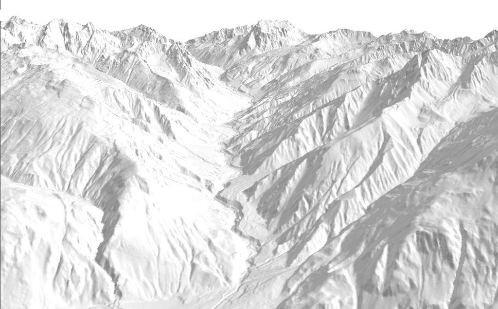
8 Photogrammetry Geo Geometry the Earth object-based area-based Vienna, July 4, 2010 Beyond the ISPRS Centenary 8 Germanisches Nationalmuseum Nürnberg


9 object based Photogrammetry Geo Geometry the Earth Photogrammetry area based Image object-based area-based Physics understanding Processes Vienna, July 4, 2010 Beyond the ISPRS Centenary 9


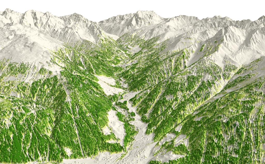
10 from States to Processes Vienna, July 4, 2010 Beyond the ISPRS Centenary 10

11 Omnipresent Geo-data Geo-data infrastructures (GDI) and ubiquituos geo-information Virtual Globes: NASA, Google, Microsoft, Navigation LBS Web 2.0 geodata mash-ups

12 Omnipresent Geo-data Spatial data infrastructures (SDI) and ubiquituos geo-information Virtual Globes: NASA, Google, Microsoft, Navigation LBS Web 2.0 geodata mash-ups Wiki mapping, collaborative mapping, crowd sourcing, interest driven update stream Free global Geo-data SRTM CBERS, open street map
13 Omnipresent Geo-data ISPRS National SDI Commercial SDI Open-Source SDI Methods for collaboration still open Academic contribution to Open Source GDI very little Free national Orthophotos, US-Lidar for the nation EuroSDR: Crowd sourcing for updating national databases

 Moravské")
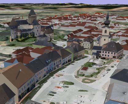
14 ISPRS Standard Products Input for topographic maps Orthophotos Terrain models 3D city models (roof landscape and facades) Moravské Budějovice Satellite image classifications
15 ISPRS Mission geo-data and 3D models for a sustainable development of the natural and cultural environment How to reach this during the next 100 years? Exploit new sensor technology Increase automation in modeling Adopt new applications Strengthen Sensor Method Application feedback


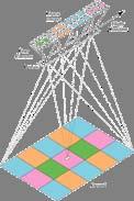
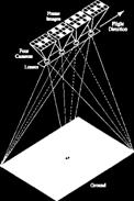

16 New Sensors Vexcel Patent Vienna, July 4, 2010 Beyond the ISPRS Centenary 16


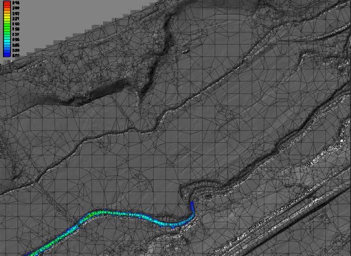
17 Improve Automation Photogrammetry: Remote Sensing: Lack of Automation Lack of Reliability / Transferability km Efficient represenation and retrieval of implicit and explicit knowledge and experience 2 148,940,000 km Land Vienna, July 4, 2010 Beyond the ISPRS Centenary SPOT Classification by Kressler, Kim, Steinocher 17


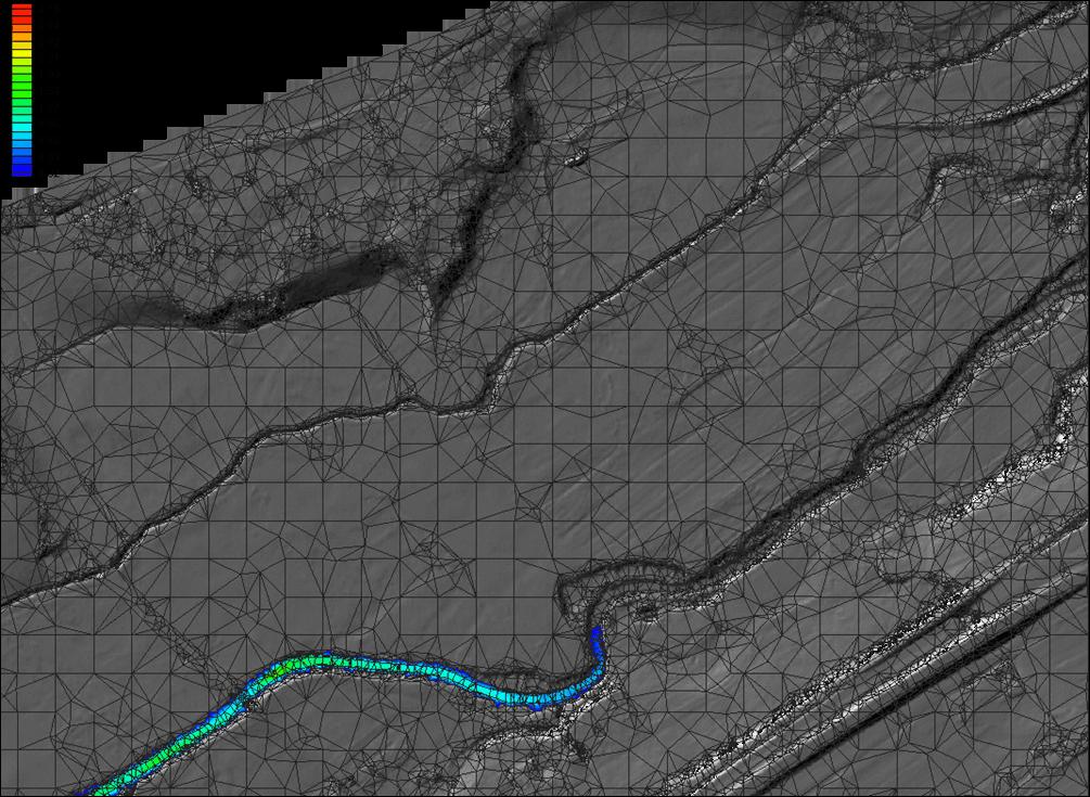
18 Cartography, Urban Planning, GDI Industry, Cultural Heritage New Applications Quantification Processes Geography, Geomorphology, Geology Biology, Ecology, Forestry Simon Buckley, Norway Vienna, July 4, 2010 Beyond the ISPRS Centenary 18


19 Sensors Methods Applications Feedback Feed Forward Loops be scientifically sustainable by persistent development of methods Vienna, July 4, 2010 Beyond the ISPRS Centenary 19
20 Conclusions Plenty of questions to be answered and problems to be solved ISPRS impact on development in sensors & methods Openness for applications & sensors essential Modeling of geo-physical (and geo-social!) processes Integration of geometry and physics 3D model global geo-physical 3D model


21 Happy birthday ISPRS! Vienna, July 4,
Challenges in Photogrammetry and Remote Sensing
 Challenges in Photogrammetry and Remote Sensing Norbert Pfeifer Vienna University of Technology Institute of Photogrammetry and Remote Sensing I.P.F. Statements Photogrammetry is finished Professor Rinner
EuroSDR (European Spatial Data Research)
") EuroSDR (European Spatial Data Research) ROLLING RESEARCH PLAN 2015-2018 EuroSDR Secretariat Public Governance Institute KU Leuven Parkstraat 45 bus 3609 3000 Leuven Belgium Tel.: +32 16 32 31 80 Fax:
EuroSDR (European Spatial Data Research) ROLLING RESEARCH PLAN 2015-2018 EuroSDR Secretariat Public Governance Institute KU Leuven Parkstraat 45 bus 3609 3000 Leuven Belgium Tel.: +32 16 32 31 80 Fax:
Challenges in data management during disasters
 Challenges in data management during disasters Sisi Zlatanova Associate Professor section GIST technology Leader Theme Group Geo-information for Crisis management OTB Research Institute for the built Environment
Themes for Geomatics Conference. Geodesy Themes
 Themes for Geomatics Conference Geodesy Themes Geodynamics o Modeling the Deformation of the Earth s Crust o Recent Advances in Geometric Approaches to Deformation Analysis o Monitoring Systems (Sensors
USING GIS CARTOGRAPHIC MODELING TO ANALYSIS SPATIAL DISTRIBUTION OF LANDSLIDE SENSITIVE AREAS IN YANGMINGSHAN NATIONAL PARK, TAIWAN
 CO-145 USING GIS CARTOGRAPHIC MODELING TO ANALYSIS SPATIAL DISTRIBUTION OF LANDSLIDE SENSITIVE AREAS IN YANGMINGSHAN NATIONAL PARK, TAIWAN DING Y.C. Chinese Culture University., TAIPEI, TAIWAN, PROVINCE
Cutting Edge Engineering for Modern Geospatial Systems Rear Admiral Dr. S Kulshrestha, retd
 Cutting Edge Engineering for Modern Geospatial Systems Rear Admiral Dr. S Kulshrestha, retd 11 Jun 2015 GeoIntelligence Asia 2015 The technology would become so pervasive that it becomes a part of you
Introduction. Elevation Data Strategy. Status and Next Steps
 1 2 Introduction Elevation Data Strategy Status and Next Steps 3 Canada is the 2nd largest country in the world - 9.9 million sq km Surrounded by 3 oceans with 202 000 km of coastline Population over 35
GEOMATICS. Shaping our world. A company of
 GEOMATICS Shaping our world A company of OUR EXPERTISE Geomatics Geomatics plays a mayor role in hydropower, land and water resources, urban development, transport & mobility, renewable energy, and infrastructure
Spanish national plan for land observation: new collaborative production system in Europe
 ADVANCE UNEDITED VERSION UNITED NATIONS E/CONF.103/5/Add.1 Economic and Social Affairs 9 July 2013 Tenth United Nations Regional Cartographic Conference for the Americas New York, 19-23, August 2013 Item
Remote Sensing and EO activities at the University of Turku
 Remote Sensing and EO activities at the University of Turku Niina Käyhkö Associate Professor Department of Geography and Geology GEO meeting/syke May 23rd, 2018 Geospatial competence at the University
Urban Geo-Informatics John W Z Shi
 Urban Geo-Informatics John W Z Shi Urban Geo-Informatics studies the regularity, structure, behavior and interaction of natural and artificial systems in the urban context, aiming at improving the living
Basics of GIS reviewed
 Basics of GIS reviewed Martin Breunig Karlsruhe Institute of Technology martin.breunig@kit.edu GEODETIC INSTITUTE, DEPARTMENT OF CIVIL ENGINEERING, GEO AND ENVIRONMENTAL SCIENCES, CHAIR IN GEOINFORMATICS
Sustainable and Harmonised Development for Smart Cities The Role of Geospatial Reference Data. Peter Creuzer
 Sustainable and Harmonised Development for Smart Cities The Role of Geospatial Reference Data Peter Creuzer 1. Introduction - Smart Cities and Geodata 2. Geodata in Germany 3. Examples 4. Data and Service
INTEGRATION OF HIGH RESOLUTION QUICKBIRD IMAGES TO GOOGLEEARTH
 INTEGRATION OF HIGH RESOLUTION QUICKBIRD IMAGES TO GOOGLEEARTH M. Alkan a, *, U.G. Sefercik a, M. Oruç a a ZKU, Engineering Faculty, 67100 Zonguldak, Turkey - (mehmetalkan44@yahoo.com) Interactive Sessions,
EuroGEOSS Protected Areas Pilot
 EuroGEOSS Protected Areas Pilot Max Craglia European Commission Joint Research Centre Part 1: the present MyNatura2000 Mobile app. Awareness raising & volunteered data collection. Natura2000 covers 18%
THE RESEARCH GOALS AND THE RESEARCH STRATEGY OF THE EuroSDR
 THE RESEARCH GOALS AND THE RESEARCH STRATEGY OF THE EuroSDR Martien Molenaar Vice President of EuroSDR International Institute for geo-information Science and Earth Observation (ITC) Enschede, The Netherlands
GEOGRAPHY (GE) Courses of Instruction
 Courses of Instruction") GEOGRAPHY (GE) GE 102. (3) World Regional Geography. The geographic method of inquiry is used to examine, describe, explain, and analyze the human and physical environments of the major regions of the
GEOGRAPHY (GE) GE 102. (3) World Regional Geography. The geographic method of inquiry is used to examine, describe, explain, and analyze the human and physical environments of the major regions of the
Land Use in the context of sustainable, smart and inclusive growth
 Land Use in the context of sustainable, smart and inclusive growth François Salgé Ministry of sustainable development France facilitator EUROGI vice president AFIGéO board member 1 Introduction e-content+
European Spatial Data Research. EuroSDR. Prof. Dr. Ir. Joep Crompvoets. General Assembly CLGE Tirana 18 March
 EuroSDR Prof. Dr. Ir. Joep Crompvoets General Assembly CLGE - 2016 Tirana 18 March 2016 INTRODUCTORY QUESTIONS Who knows what is EuroSDR? Who does NOT know what is EuroSDR? Who is employed at mapping agencies?
XXIII CONGRESS OF ISPRS RESOLUTIONS
 XXIII CONGRESS OF ISPRS RESOLUTIONS General Resolutions Resolution 0: Thanks to the Czech Society commends: To congratulate The Czech Society, its president and the Congress Director Lena Halounová, the
Belfairs Academy GEOGRAPHY Fundamentals Map
 YEAR 12 Fundamentals Unit 1 Contemporary Urban Places Urbanisation Urbanisation and its importance in human affairs. Global patterns of urbanisation since 1945. Urbanisation, suburbanisation, counter-urbanisation,
Virtual 3D Cities. Chapter VIII. Virtual 3D Cities. 8.1 Introduction. Components. Chapter VIII: Virtual 3D Cities 1
 Chapter VIII Virtual 3D Cities 8.1 Introduction 8.2 CityGML 8.3 Google Earth 8.4 Virtual Earth 8.5 Conclusions Virtual 3D Cities 8.1 Introduction 3D Visualization of cities Languages such as CityGML New
ESRI Survey Summit August Clint Brown Director of ESRI Software Products
 ESRI Survey Summit August 2006 Clint Brown Director of ESRI Software Products Cadastral Fabric How does Cadastral fit with Survey? Surveyors process raw field observations Survey measurements define high-order
GIS and Remote Sensing
 Spring School Land use and the vulnerability of socio-ecosystems to climate change: remote sensing and modelling techniques GIS and Remote Sensing Katerina Tzavella Project Researcher PhD candidate Technology
Maanmittauspäivät 2018 Helsinki Maanmittauspäivät 2018 The Danish initiatives regarding open and free basic data including effect studies
 Maanmittauspäivät 2018 The Danish initiatives regarding open and free basic data including effect studies 22.03.2018 Agenda 1. Intro overall frame / selfie 2. Data Infrastructure 3. The Danish Digital
Spatial Data Science. Soumya K Ghosh
 Workshop on Data Science and Machine Learning (DSML 17) ISI Kolkata, March 28-31, 2017 Spatial Data Science Soumya K Ghosh Professor Department of Computer Science and Engineering Indian Institute of Technology,
THE ESTABLISHMENT OF DIGITAL HIGH RESOLUTION GEODATABASES FOR WEBGIS: FROM DIGITAL CAMPUS TO DIGITAL NATIONAL PARK
 THE ESTABLISHMENT OF DIGITAL HIGH RESOLUTION GEODATABASES FOR WEBGIS: FROM DIGITAL CAMPUS TO DIGITAL NATIONAL PARK Y. C. Ding a, *, C. C. Huang a a Digital Earth Research Center (DERC), Chinese Culture
Georeferencing and Satellite Image Support: Lessons learned, Challenges and Opportunities
 Georeferencing and Satellite Image Support: Lessons learned, Challenges and Opportunities Shirish Ravan shirish.ravan@unoosa.org UN-SPIDER United Nations Office for Outer Space Affairs (UNOOSA) UN-SPIDER
G. I. Science Education: A Computing Perspective
 A Position Statement on G. I. Science Education: A Computing Perspective (A Panel Discussion in UCGIS Summer Assembly 2008) By Shashi Shekhar McKnight Distinguished University Professor Faculty of Computer
Urban land cover and land use extraction from Very High Resolution remote sensing imagery
 Urban land cover and land use extraction from Very High Resolution remote sensing imagery Mengmeng Li* 1, Alfred Stein 1, Wietske Bijker 1, Kirsten M.de Beurs 2 1 Faculty of Geo-Information Science and
History & Scope of Remote Sensing FOUNDATIONS
 History & Scope of Remote Sensing FOUNDATIONS Lecture Overview Introduction Overview of visual information Power of imagery Definition What is remote sensing? Definition standard for class History of Remote
Disaster Management & Recovery Framework: The Surveyors Response
 Disaster Management & Recovery Framework: The Surveyors Response Greg Scott Inter-Regional Advisor Global Geospatial Information Management United Nations Statistics Division Department of Economic and
SA Geospatial Analysis Platform (GAP) Methodology*, collaborators & data sources
 Methodology*, collaborators & data sources") SA Geospatial Analysis Platform (GAP) Methodology*, collaborators & data sources Mesoframe CSIR, dti, the Presidency & GTZ Demarcation of South Africa into a grid of 50 Km 2 mesozones, nested within important
SA Geospatial Analysis Platform (GAP) Methodology*, collaborators & data sources Mesoframe CSIR, dti, the Presidency & GTZ Demarcation of South Africa into a grid of 50 Km 2 mesozones, nested within important
Open spatial data infrastructure
 Open spatial data infrastructure a backbone for digital government Thorben Hansen Geomatikkdagene 2018 Stavanger 13.-15. mars Spatial Data Infrastructure definition the technology, policies, standards,
"GIS-Sofia" Ltd. geospatial data integration in SOFCAR geographic information system and providing services March 2018, Sofia
 "GIS-Sofia" Ltd. geospatial data integration in SOFCAR geographic information system and providing services Geographical Information System Sofia " Ltd....the beginning... Established in 1999, as a Sofia
Creating and Using 3D City Models
 Creating and Using 3D City Models Traditional 3D City Models vs. Google Earth and Virtual Earth Wolfgang Dokonal Graz University of Technology http://www.stdb.tugraz.at Dokonal@tugraz.at Abstract. City
INDONESIA S S UPDATE: GEOSPATIAL INFORMATION FOR SUSTAINABLE DEVELOPMENT RELATED TO INA SDI Dr. Asep Karsidi, M.Sc
 INDONESIA S S UPDATE: GEOSPATIAL INFORMATION FOR SUSTAINABLE DEVELOPMENT RELATED TO INA SDI Dr. Asep Karsidi, M.Sc GEOSPATIAL INFORMATION AGENCY 08 August, 2012 OUTLINE 1. Transformation Bakosurtanal into
A Broad View of Geospatial Technology & Systems
 A Broad View of Geospatial Technology & Systems Pete Large Vice President, Trimble On the shoulders of giants 1 Since their time, our ability to generate geospatial information has grown exponentially
Challenges and Potentials of Place Based Information Management in Nepal"
 Nineteenth United Nations Regional Cartographic Conference for Asia and the Pacific, Bangkok, Thailand, 29 October 1 November 2012 Challenges and Potentials of Place Based Information Management in Nepal"
Introduction To A New Geo-Referenced Street Level Content: 3D GEOPANO
 Free and Open Source Software for Geospatial (FOSS4G) Conference Proceedings Volume 15 Seoul, South Korea Article 10 2015 Introduction To A New Geo-Referenced Street Level Content: 3D GEOPANO Boram Yoon
3D BUILDING MODELS IN GIS ENVIRONMENTS
 A. N. Visan 3D Building models in GIS environments 3D BUILDING MODELS IN GIS ENVIRONMENTS Alexandru-Nicolae VISAN, PhD. student Faculty of Geodesy, TUCEB, alexvsn@yahoo.com Abstract: It is up to us to
State of Israel Ministry of Housing and Construction Survey of Israel. The Hydrological project case
 State of Israel Ministry of Housing and Construction Survey of Israel The Hydrological project case Survey of Israel Content Introduction To the Survey of Israel The operation assumptions The main responsibilities
1. Pass GE1101E Geographical Journeys: Exploring World Environments. This will be counted towards the Faculty Core or UE requirements.
 H Geography At the Department of Geography, students are encouraged to develop a deeper and more critical understanding of both physical and human environments. Students will acquire knowledge, skills
SPURRING NATION S ECONOMY THROUGH SmartKADASTER
 SPURRING NATION S ECONOMY THROUGH SmartKADASTER SR MOHAMAD KAMALI BIN ADIMIN DIVISION DIRECTOR (CADASTRE) DEPARTMENT OF SURVEY AND MAPPING MALAYSIA THE NEED TO TRANSFORM TRANSFORMATION AGENDA EMPOWERING
Building a Vibrant and Enduring Spatial Science John P. Wilson IWGIS2014 Beijing, China
 Building a Vibrant and Enduring Spatial Science John P. Wilson IWGIS2014 Beijing, China Outline Spatial roots o Geography o Landscape architecture o Computer science The (current) opportunity Guiding principles
Compact guides GISCO. Geographic information system of the Commission
 Compact guides GISCO Geographic information system of the Commission What is GISCO? GISCO, the Geographic Information System of the COmmission, is a permanent service of Eurostat that fulfils the requirements
Economic Benefit Study on Value of Spatial Information Australian Experience
 Economic Benefit Study on Value of Spatial Information Australian Experience Dr Zaffar Sadiq Mohamed-Ghouse Director, International Relations Cooperative Research Centre for Spatial Information zsadiq@crcsi.com.au
GENERATION OF 3D CITY MODELS FROM TERRESTRIAL LASER SCANNING AND AERIAL PHOTOGRAPHY: A CASE STUDY
 GENERATION OF 3D CITY MODELS FROM TERRESTRIAL LASER SCANNING AND AERIAL PHOTOGRAPHY: A CASE STUDY Hakan KARABORK 1, Fatih SARI 1 1 Selcuk University in Konya, Faculty of Engineering and Architecture Konya,
Land Accounts - The Canadian Experience
 Land Accounts - The Canadian Experience Development of a Geospatial database to measure the effect of human activity on the environment Who is doing Land Accounts Statistics Canada (national) Component
Better Topographic Map Production Using ArcGIS. A Comprehensive Solution for Mapping Organizations
 Better Topographic Map Production Using ArcGIS A Comprehensive Solution for Mapping Organizations The World Is Always Changing As a member of a national mapping organization, you know this is true. You
THE NEW CHALLENGES FOR THE HIGHER EDUCATION OF GEODESY IN UACEG SOFIA
 THE NEW CHALLENGES FOR THE HIGHER EDUCATION OF GEODESY IN UACEG SOFIA Ivan Kunchev University of Architecture, Civil Engineering and Geodesy, 1 Hristo Smirnenski Blvd., Sofia 1046, Bulgaria Abstract Report
Faculty of Science and Technology Parthenope University Napoli
 Faculty of Science and Technology Parthenope University Napoli First Level Degree Course in COMPUTER SCIENCE (class L-31 DM 17) Years I and II running Computer Architecture with laboratory INF/01 12 Mathematics
Research Group Cartography
 Research Group Cartography Research Group Cartography Towards supporting wayfinding LBS components 1. Mobile devices 2. Communication Network 3. Positioning Component 4. Service and Application Provider
DEPARTMENT OF GEOGRAPHY B.A. PROGRAMME COURSE DESCRIPTION
 DEPARTMENT OF GEOGRAPHY B.A. PROGRAMME COURSE DESCRIPTION (3 Cr. Hrs) (2340100) Geography of Jordan (University Requirement) This Course pursues the following objectives: - The study the physical geographical
Integration of Geo spatial and Statistical Information: The Nepelese Experience
 Integration of Geo spatial and Statistical Information: The Nepelese Experience Krishna Raj B.C. Joint Secretary Ministry of Land Reform and Management, Nepal 11 June, 2014 Presentation Outline The Country
Exploring the boundaries of your built and natural world. Geomatics
 Exploring the boundaries of your built and natural world Geomatics Before the Luxor brought magic to the Las Vegas strip and before the South LRT extension in Edmonton gave residents a new route to travel,
Cartographic and Geospatial Futures
 Cartographic and Geospatial Futures 1. Web Cartography, WebGIS, & Virtual Globes--New Roles for Maps, GIS, and GIS professionals 2. Map Mashups, the Neo Neo-geography Movement, & Crowd-sourcing Geospatial
8/28/2011. Contents. Lecture 1: Introduction to GIS. Dr. Bo Wu Learning Outcomes. Map A Geographic Language.
 Contents Lecture 1: Introduction to GIS Dr. Bo Wu lsbowu@polyu.edu.hk Department of Land Surveying & Geo-Informatics The Hong Kong Polytechnic University 1. Learning outcomes 2. GIS definition 3. GIS examples
ENVS S102 Earth and Environment (Cross-listed as GEOG 102) ENVS S110 Introduction to ArcGIS (Cross-listed as GEOG 110)
 ENVS S110 Introduction to ArcGIS (Cross-listed as GEOG 110)") ENVS S102 Earth and Environment (Cross-listed as GEOG 102) 1. Describe the fundamental workings of the atmospheric, hydrospheric, lithospheric, and oceanic systems of Earth 2. Explain the interactions
ENVS S102 Earth and Environment (Cross-listed as GEOG 102) 1. Describe the fundamental workings of the atmospheric, hydrospheric, lithospheric, and oceanic systems of Earth 2. Explain the interactions
Manual of Digital Earth
 V8.0 March 27, 2018 International Society for Digital Earth Manual of Digital Earth (Tentative Title) OUTLINE Foreword Chapter 1 Understanding Digital Earth 1.1 Origins and Precursors of Digital Earth
Disaster Management in Mongolia
 The Third UN-GGIM-AP Plenary Meeting Disaster Management in Mongolia ~Coordination among NGIA & Other Related Organizations and Recommendations~ Bali Indonesia 10 November 2014 Khurelshagai Ayurzana, Director
Dutch spatial planning: from implicit to explicit sustainable urban development
 Dutch spatial planning: from implicit to explicit sustainable urban development Jan Goedman (VROM*) Wim Heiko Houtsma (VROM) Wil Zonneveld (Delft University) *Dutch Ministry of Housing, Spatial Planning
The Relevance of Cartography. Dubai 2015, Georg Gartner
 The Relevance of Cartography Dubai 2015, Georg Gartner Where are we? Data! Data? We are not short of data Technologies! Technologies? We are not short of technologies Data-driven and technology-driven
United Nations International Conference on Spacebased Technologies for Disaster Risk Reduction
 United Nations International Conference on Spacebased Technologies for Disaster Risk Reduction Muti-resource data management and sustainable development indicators related to the monitoring of cultural
Labour Market Areas in Italy. Sandro Cruciani Istat, Italian National Statistical Institute Directorate for territorial and environmental statistics
 Labour Market Areas in Italy Sandro Cruciani Istat, Italian National Statistical Institute Directorate for territorial and environmental statistics Workshop on Developing European Labour Market Areas Nuremberg,
Report on the impact of open geographical data - Danish effect studies -
 Presented at the FIG Congress 2018, May 6-11, 2018 in Istanbul, Turkey Report on the impact of open geographical data - Danish effect studies - (Paper no 9603) Agenda 1. Intro teaser 2. Basic digital infrastructure
Pathways. Pathways through the Geography Major
 Pathways through the Major majors may structure their course selections around a sub-field of. Pathways are suggestions for classes in, in related disciplines, and skills training. Each pathway includes
What is special about geospatial? or A discipline in constant transition
 What is special about geospatial? or A discipline in constant transition Marinos Kavouras NTUA Ensuring the Rapid Response to Change, Ensuring the Surveyor of Tomorrow FIG 2015 Several paradigm shifts
3D MAPS SCALE, ACCURACY, LEVEL OF DETAIL
 26 th International Cartographic Conference August 25 30, 2013 Dresden, Germany 3D MAPS SCALE, ACCURACY, LEVEL OF DETAIL Prof. Dr. Temenoujka BANDROVA Eng. Stefan BONCHEV University of Architecture, Civil
Graduate Courses Meteorology / Atmospheric Science UNC Charlotte
 Graduate Courses Meteorology / Atmospheric Science UNC Charlotte In order to inform prospective M.S. Earth Science students as to what graduate-level courses are offered across the broad disciplines of
Excel Geomatics: Offering Excellence with Unique Consultancy & Services
 Excel Geomatics: Offering Excellence with Unique Consultancy & Services Providing consultancy and value Added Services using Remote Sensing, Photogrammetry and LiDAR in areas such as Agriculture, Forestry,
Urbanization and Sustainable Development of Cities: A Ready Engine to Promote Economic Growth and Cooperation
 Urbanization and Sustainable Development of Cities: A Ready Engine to Promote Economic Growth and Cooperation Wan Portia Hamzah Institute of Strategic and International Studies (ISIS) Malaysia 10 September
Data for Spatial Planning A Comparison of Three Cities
 Data for Spatial Planning A Comparison of Three Cities Dr. Gerhard Navratil1 Dr. Johannes Scholz1 DI Ladislav Danek2 Dr. Farid Karimipour3 1 TU Vienna, Institute of Geoinformation and Cartography, Austria
Molinaro Keyword: Geography. Associate Professors: Walasek, Ph.D.; (Chair), Wolf, Ph.D.
, Wolf, Ph.D.") 126 - Geography GENERAL INFO GRADUATE UNDREGRADUATE ADULT/NON-TRAD POLICIES STUDENT LIFE ADMISSIONS INTRODUCTION Degree Offered: Bachelor of Arts. Associate Professors: Walasek, Ph.D.; (Chair), Wolf, Ph.D.
126 - Geography GENERAL INFO GRADUATE UNDREGRADUATE ADULT/NON-TRAD POLICIES STUDENT LIFE ADMISSIONS INTRODUCTION Degree Offered: Bachelor of Arts. Associate Professors: Walasek, Ph.D.; (Chair), Wolf, Ph.D.
Planning in a Geospatially Enabled Society. Michael F. Goodchild University of California Santa Barbara
 Planning in a Geospatially Enabled Society Michael F. Goodchild University of California Santa Barbara What is a geospatially enabled society? Knowing the locations of all points of interest and their
SDG s and the role of Earth Observation
 SDG s and the role of Earth Observation Christian Heipke IPI - Institute for Photogrammetry and GeoInformation Leibniz Universität Hannover Germany Secretary General, ISPRS 1. No Poverty 2. Zero Hunger
Future Proofing the Provision of Geoinformation: Emerging Technologies
 Future Proofing the Provision of Geoinformation: Emerging Technologies An Exchange Forum with the Geospatial Industry William Cartwright Chair JBGIS Second High Level Forum on Global Geospatial Information
Geoinformation Science at TU Berlin
 Technische Universität Berlin Department of Geoinformation Science Geoinformation Science at TU Berlin Prof. Dr. Thomas H. Kolbe Institute for Geodesy and Geoinformation Science Berlin University of Technology
Spatially enabling e-government through geo-services
 Spatially enabling e-government through geo-services Mauro Salvemini EUROGI PRESIDENT Professor at Sapienza Università di Roma (IT) 1 About the presentation Few information about Eurogi ; Some essential
May 2011 Oracle Spatial User Conference
 May 2011 Oracle Spatial User Conference Oracle Spatial User Conference! May 19, 2011 Ronald Reagan Building and International Trade Center Washington, DC USA May 2011 Oracle Spatial User Conference Francois
Rethinking Urbanization in the 21 st Century
 Rethinking Urbanization in the 21 st Century Karen C. Seto Professor of Geography & Urbanization Science School of Forestry & Environmental Studies Yale University SESYNC April 13, 2016 From now until
REGULATIONS FOR THE POSTGRADUATE DIPLOMA IN GEOGRAPHIC INFORMATION SYSTEMS (PDipGIS)
") 182 REGULATIONS FOR THE POSTGRADUATE DIPLOMA IN GEOGRAPHIC INFORMATION SYSTEMS (PDipGIS) (See also General Regulations) PDGIS 1 Admission requirements To be eligible for admission to studies leading to
182 REGULATIONS FOR THE POSTGRADUATE DIPLOMA IN GEOGRAPHIC INFORMATION SYSTEMS (PDipGIS) (See also General Regulations) PDGIS 1 Admission requirements To be eligible for admission to studies leading to
Economic and Social Council 2 July 2015
 ADVANCE UNEDITED VERSION UNITED NATIONS E/C.20/2015/11/Add.1 Economic and Social Council 2 July 2015 Committee of Experts on Global Geospatial Information Management Fifth session New York, 5-7 August
STEREO ANALYST FOR ERDAS IMAGINE Stereo Feature Collection for the GIS Professional
 STEREO ANALYST FOR ERDAS IMAGINE Stereo Feature Collection for the GIS Professional STEREO ANALYST FOR ERDAS IMAGINE Has Your GIS Gone Flat? Hexagon Geospatial takes three-dimensional geographic imaging
CARTOGRAPHIC INFORMATION MANAGEMENT IN COLOMBIA REACH A LEVEL OF PERFECTION
 CARTOGRAPHIC INFORMATION MANAGEMENT IN COLOMBIA REACH A LEVEL OF PERFECTION Jaime Alberto Duarte Castro 1 Carrera 30 No. 48 51 Bogotá - Colombia, jduarte@igac.gov.co Claudia Inés Sepúlveda Fajardo 2 Carrera
Historical Assessment of Spatial Growth of Builtups in Metropolitan areas of Delhi and Mumbai in India and Dhaka in Bangladesh
 Historical Assessment of Spatial Growth of Builtups in Metropolitan areas of Delhi and Mumbai in India and Dhaka in Bangladesh Tomas Soukup, GISAT BBL session, World Bank HQ, Washington DC Date : 10 January
GEOGRAPHY, ENVIRONMENT, AND SUSTAINABILITY (GES)
") Geography, Environment, and Sustainability (GES) 1 GEOGRAPHY, ENVIRONMENT, AND SUSTAINABILITY (GES) GES 102 The Historical Geography of the Western World 3 A study of the geographical factors which combine
Geography, Environment, and Sustainability (GES) 1 GEOGRAPHY, ENVIRONMENT, AND SUSTAINABILITY (GES) GES 102 The Historical Geography of the Western World 3 A study of the geographical factors which combine
Faculty Environmental Sciences» Department Geosciences» Chair for Geoinformationsystems Developing Scientific GDI DGEO Workshop
 Faculty Environmental Sciences» Department Geosciences» Chair for Geoinformationsystems Developing Scientific GDI DGEO Workshop Lars Bernard, Stephan Mäs February 2013 TU Dresden GIS Team Chair Geoinformationsystems
Geography at Oxford Dr Lorraine Wild
 Open Day 2018 Geography at Oxford Geography at Oxford Dr Lorraine Wild Why is Oxford special? Why is Oxford special? The School of Geography and the Environment has been ranked 1 st in the 2018 QS World
ZRCSAZU. Remote sensing and Earth observation data at ZRC SAZU. dr. Tatjana Veljanovski Atrij ZRC Ljubljana
 ZRCSAZU Remote sensing and Earth observation data at ZRC SAZU dr. Tatjana Veljanovski 2016-06-08 Atrij ZRC Ljubljana Remote Sensing Department Remote Sensing Department 20 years of experience application,
Building a National Data Repository
 Building a National Data Repository Mladen Stojic, Vice President - Geospatial 1/30/2013 2012 Intergraph Corporation 1 Information has meaning and gives power only when shared and distributed. Information,
Smart Citizens. Maria Antonia Brovelli Politecnico di Milano, Italy
 Smart Citizens Maria Antonia Brovelli Politecnico di Milano, Italy UN-GGIM Academic Network Forum Secure Land Rights and Smart Cities: Making It Work for Sustainable Development New York, 31 July 2017
SDI DEVELOPMENT UPDATES OF INDONESIA
 SDI DEVELOPMENT UPDATES OF INDONESIA DR. ANTONIUS B. WIJANARTO Center For Management And Dissemination Of Geospatial Information GEOSPATIAL INFORMATION AUTHORITY GOVERNMENT OF THE REPUBLIC OF INDONESIA
Introduction of the Asia-Oceania Global Earth Observation System of Systems (AOGEOSS) GEO Initiative(GI-22 )
 GEO Initiative(GI-22 )") Introduction of the Asia-Oceania Global Earth Observation System of Systems (AOGEOSS) GEO Initiative(GI-22 ) Prof. Xiang ZHOU Institute of Remote Sensing and Digital Earth, CAS 11 May 2017 Kunming, China
Introduction of the Asia-Oceania Global Earth Observation System of Systems (AOGEOSS) GEO Initiative(GI-22 ) Prof. Xiang ZHOU Institute of Remote Sensing and Digital Earth, CAS 11 May 2017 Kunming, China
COURSE OUTLINE. GEO 101 Geography 3 Course Number Course Title Credits. Reference Liberal Arts Division Book List
 MERCER COUNTY COMMUNITY COLLEGE LIBERAL ARTS DIVISION COURSE OUTLINE GEO 101 Geography 3 Course Number Course Title Credits Required Materials: Catalog Description: Reference Liberal Arts Division Book
Building a validation database for land cover products from high spatial resolution images
 Building a validation database for land cover products from high spatial resolution images The Land Cover project of the ESA Climate Change Initiative Bontemps Sophie 1, Achard Frédéric 2, Lamarche Céline
Harmonizing spatial databases and services at local and regional level
 Harmonizing spatial databases and services at local and regional level A. Ionita 1, M. Caian 2, V. Vassilev 3, V. Craciunescu 2, I. Nedelcu 4 1 Research Institute for Artificial Intelligence, Bucuresti,
Exploit your geodata to enable smart cities and countries
 Exploit your geodata to enable smart cities and countries Carsten Rönsdorf, Head of Advisory Services Middle East Practice Manager Future Cities, standards and 3D 24 November 2014 Importance of Standards
KUNMING FORUM ON UNITED NATIONS GLOBAL GEOSPATIAL INFORMATION MANAGEMENT CITIES OF THE FUTURE: SMART, RESILIENT
 KUNMING FORUM ON UNITED NATIONS GLOBAL GEOSPATIAL INFORMATION MANAGEMENT CITIES OF THE FUTURE: SMART, RESILIENT and SUSTAINABLE Yunnan Zhenzhuang Guest House, Kunming, China 10 12 May 2017 BACKGROUND CONCEPT
Contemporary Data Collection and Spatial Information Management Techniques to support Good Land Policies
 Contemporary Data Collection and Spatial Information Management Techniques to support Good Land Policies Ch. Ioannidis Associate Professor FIG Commission 3 Workshop Paris, 25-28 October 2011 Introduction