EAGRE 2018 EAst GREenland caves Summer 2018
|
|
|
- Bethany Moore
- 6 years ago
- Views:
Transcription

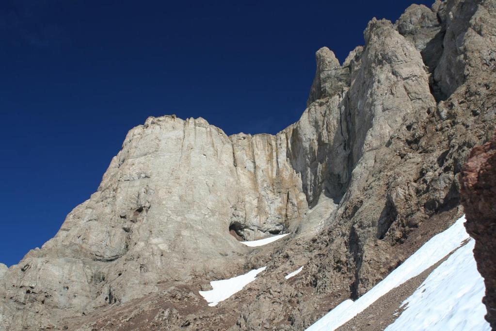
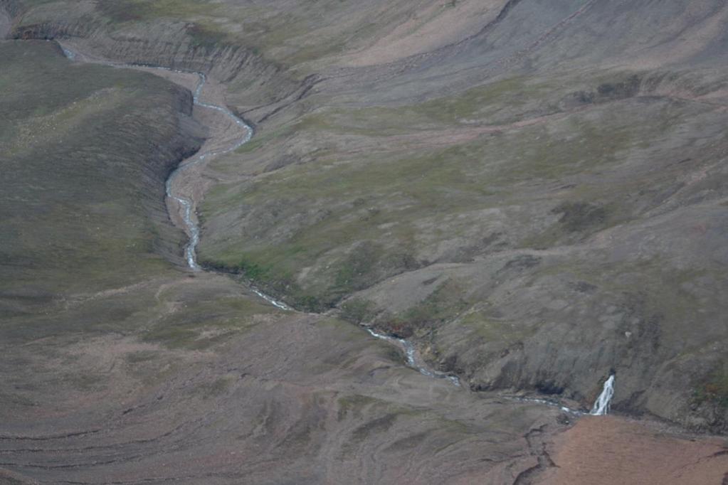
1 EAGRE 2018 EAst GREenland caves Summer 2018 An adventure-based climate research expedition to the Wegener Halvø Peninsula of East Greenland Scientific Importance The Arctic region is expected to experience some of the greatest climate and environmental changes in the next centuries as a result of climate change, and the consequences of these changes will be experienced worldwide. Improving understanding of how the Arctic responds to different forcing mechanisms is thus of paramount importance, but is hampered by a lack of available records that can provide this information. In particular, records of climate and environmental change for coastal areas of Greenland are sparse, thus (1) it is not possible to place the current warming trend in the context of past changes and natural variability, and (2) models that predict future changes cannot be validated against observational data in the past. Our Mission Building on a successful pioneering pilot study led by the project leader (Moseley, this project seeks to address this knowledge gap by constructing records of climate and environmental change from sediments in caves on the Wegener Halvø peninsula in EAst GREenland (EAGRE Project). Typically cave-based climate researchers use stalagmites to construct records of past climate change, but this project is unique in its approach as it will aim to use sediments instead. In doing so, we will apply the most up-to-date techniques that are normally used on deep-sea sediments. The project is expected to yield a Holocene (c. last 10,000 years) record of climate and environmental change for coastal Greenland, and thus will be complementary to the recently drilled RECAP ice core located 80 km away. Goals and Objectives The goals are highly ambitious, but if successful offer the potential for high gain! The objectives are to: (1) Explore the Wegener Halvø peninsula of East Greenland for caves, and to explore, map, document and photograph them where they are found. (2) Collect sedimentary samples from the caves. (3) Construct records of climate and environmental change from the samples. (4) Interpret the EAGRE records with respect to e.g., climate stability and abrupt events; synchronicity with the nearby RECAP ice core and marine records; and teleconnections with distant regions. (5) Undertake public outreach throughout the duration of the project to better inform people about the issues of climate change and cave-based science, exploration and adventure. (6) Engage local Inuit communities in outdoor activities such as rock climbing.
2 Expedition The expedition will take place during the summer of 2018 and will comprise the project leader Gina Moseley, adventure photographer Robbie Shone as documentary storyteller, Dario Schwoerer as an accomplished mountain guide, caver and climatologist, and one other person who has expertise in rope-access and/or karst and speleogenesis. The expedition will take place between early July to late August, 2018, but will need to be fully flexible because of yearly differences in pack-ice extent and timing. The boat will sail from Akureyri, Iceland, to Grimsey Island and on to Ittoqqortoormiit, Greenland, and then the Wegener Halvø Peninsula. Allowing for flexibility in weather and sea conditions, this journey could take up to one week. Whilst the main expedition is in the field, Schwoerer s family will remain in Ittoqqortoormiit, Greenland, engaging with the local community. Two weeks will be spent on the Wegener Halvø peninsula, giving the team ample time to fully explore the peninsula, before returning. Where possible, the boat may be used to move down the coast, but it is also possible that we may need to set up a base camp in a central location from which day trips will be made. Technical rope expertise may be required to enter the caves if located in a cliff face. All caves will be documented, photographed and sampled to a high standard. Following the research-based part of the expedition, team members will spend up to a week undertaking community engagement with Inuit communities along the east coast. This will build on prior work of ToptoTop during August 2017 in which Inuit children were taught rock climbing skills ( Adventure and Risk The expedition is not without risk. For a start, we are going back to the roots of exploration in travelling by boat. We will need to take account of weather and sea ice and be fully flexible with timing. The peninsula has never been properly explored for caves, so we don t know what we will find. A large part of the expedition will therefore be surface exploration, but this is exciting, as any caves we do find will involve first-time exploration. To support our quest, we do know that the area is karstified meaning the limestone has been dissolved by the action of water, thus the potential for caves is extremely high. We also have a number of leads in the form of potential cave entrances that have been photographed by a geologist of the Cambridge Arctic Shelf Project. Given our location, we must also be prepared for encounters with the local wildlife. When camping, we shall need to take it in turns to be on guard for any visitors. Dissemination We will provide the widest possible access to the work of the project for both the general public and the scientific community. The website and social media feeds (23k followers) of the Northeast Greenland Caves Project will be updated to reflect the EAGRE Project. Robbie Shone is a professional cave and adventure photographer with an impressive CV (e.g., National Geographic, GEO, European Space Agency) and 231k followers on social media that will additionally ensure good publicity of the project. Capacity Building Sedimentary deposits are an underused resource in cave-based climate studies. In using them, other researchers should be encouraged to also pursue similar research. The samples will be analysed in the newly established Austrian Core Facility (located in Innsbruck), which so far has concentrated on marine and lake sediments only, thus encouraging research expansion by this group. Analysis of the sediments will be undertaken as part of bachelor and master theses. Several students will thus benefit from the samples and develop analytical skills by working on them.

3 Google map of key points
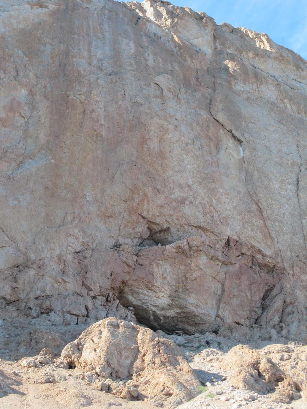
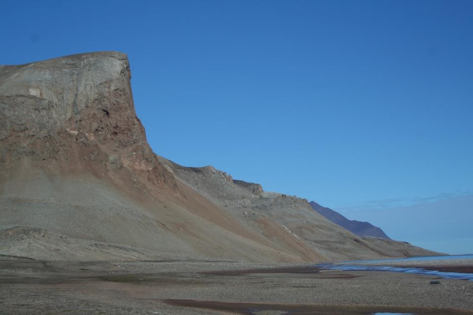
4 Cave entrances/features
5
Laura J. Crossey Bachelors Degree, Geology Masters Degree, Geology Ph.D., Geology
 Laura J. Crossey Bachelors Degree, Geology Masters Degree, Geology Ph.D., Geology BIO Laura Crossey has been at the University of New Mexico for seventeen years where she teaches Geology and does research.
MSc(Res) Polar and Alpine Change.
 Polar and Alpine Change.") Department Of Geography. MSc(Res) Polar and Alpine Change. MSc(Res) Polar and Alpine Change Our MSc(Res) Polar and Alpine Change programme provides a unique research experience that seeks to embed our
Department Of Geography. MSc(Res) Polar and Alpine Change. MSc(Res) Polar and Alpine Change Our MSc(Res) Polar and Alpine Change programme provides a unique research experience that seeks to embed our
EDUCATION PROGRAMS GUIDE
 EDUCATION PROGRAMS GUIDE Inner Space Center University of Rhode Island Graduate School of Oceanography innerspacecenter.org ABOUT THE ISC The Inner Space Center (ISC) is an international leader in ocean
Of topic specific knowledge and understanding To encourage progressive development in 'thinking geographically'
 [August 2012] Content exemplars 1. Broad description of the content: Single paragraph, written with technical precision Content rigour (avoiding generic statements) Identifying the core of essential knowledge
Subject Area: Geography
 Long Term Planning Overview Key Stage 3 Subject Area: Geography Academic : 08-9 7 Assessment Your Island Home the physical and human geography of the UK and will investigate weather patterns, population
Information Needs & Information Seeking in Internet Era: A Case Study of Geographers in Maharashtra
 International Journal of Research in Library Science ISSN: 2455-104X Indexed in: IIJIF, ijindex, SJIF,ISI Volume 2,Issue 1 (January-June) 2016,99-108 Received: 7 May 2016 ; Accepted: 12 May 2016 ; Published:
ANTARCTIC KAYAK SPONSORED BY: EXPEDITION
 ANTARCTIC KAYAK SPONSORED BY: EXPEDITION 8 FEB 2018 1000 KM 4 EXPLORER S 2 MONTHS 1 EPIC OVERVIEW A team of 4 (+2 filmmakers) will undertake a journey to navigate the Antarctic Peninsula by sea kayak for
Dalhousie University Advanced Field School 2017 SUMMARY REPORT
 Dalhousie University Advanced Field School 2017 SUMMARY REPORT Submitted to: Offshore Energy Research Association of Nova Scotia (OERA) to fulfill the requirements of the Student Research Travel Program
MEADOWS PRIMARY SCHOOL and NURSERY GEOGRAPHY POLICY
 MEADOWS PRIMARY SCHOOL and NURSERY GEOGRAPHY POLICY Purpose of study The teaching of Geography at Meadows is done by following the 2014 National Curriculum. The planning and teaching of the subject aims
A Level Geography Cambridge International Content Programme For teaching from September 2016
 A Level Geography Cambridge International Content Programme For teaching from September 2016 is located on the Start Bay coast in South Devon and is surrounded by Slapton Ley National Nature Reserve. The
Contents. Section 1: Climate Factors. Section 2: Climate Types. Section 3: Climate Effects
 Contents Section 1: Climate Factors 1. Weather or Climate?.... 2 2. Elements of Climate.... 4 3. Factors Affecting Climate.... 10 4. Comparing Climates.... 15 5. Quiz 1.... 20 Section 2: Climate Types
The North Atlantic Oscillation: Climatic Significance and Environmental Impact
 1 The North Atlantic Oscillation: Climatic Significance and Environmental Impact James W. Hurrell National Center for Atmospheric Research Climate and Global Dynamics Division, Climate Analysis Section
THE CANADIAN CENTRE FOR CLIMATE MODELLING AND ANALYSIS
 THE CANADIAN CENTRE FOR CLIMATE MODELLING AND ANALYSIS As Canada s climate changes, and weather patterns shift, Canadian climate models provide guidance in an uncertain future. CANADA S CLIMATE IS CHANGING
8UNIT. External dynamics of the Earth. What do you remember? Key language. Content objectives
 8UNIT External dynamics of the Earth What do you remember? Can you name the solids in the photograph? nd the liquid? Is the liquid moving? How does it move? What is the name of this formation of water?
DALHOUSIE ADVANCED FIELD SCHOOL SUMMARY REPORT
 DALHOUSIE ADVANCED FIELD SCHOOL SUMMARY REPORT Submitted to: Offshore Energy Research Association of Nova Scotia (OERA) to fulfill the requirements of the Student Research Travel Program Submitted by:
Currents THE MAGAZINE OF THE NORTH AMERICAN NATURE PHOTOGRAPHY ASSOCIATION. Spring 2013
 Currents THE MAGAZINE OF THE NORTH AMERICAN NATURE PHOTOGRAPHY ASSOCIATION Spring 2013 Portfolio: Arctic Documentary Project Photos by DaNIEl J. Cox / NaTUralExpOSUres.COM The Arctic Documentary Project
Use maps, atlases, globes and computer mapping to locate countries and describe features studied
 Roseberry Primary School Curriculum planning Lead Question: What s so amazing about America? National Curriculum driver: Geography Rationale statement: In this study about the amazing Americas, children
The Coast: Beaches and Shoreline Processes
 1 2 3 4 5 6 7 8 9 The Coast: es and Shoreline Processes Trujillo & Thurman, Chapter 10 Oceanography 101 Chapter Objectives Recognize the various landforms characteristic of beaches and coastal regions.
The Coast: Beaches and Shoreline Processes Trujillo & Thurman, Chapter 10
 The Coast: es and Shoreline Processes Trujillo & Thurman, Chapter 10 Oceanography 101 Chapter Objectives Recognize the various landforms characteristic of beaches and coastal regions. Identify seasonal
Grosvenor Teacher Fellowship: A Life-Changing Expedition to the Arctic By Jenny Bolch
 Grosvenor Teacher Fellowship: A Life-Changing Expedition to the Arctic By Jenny Bolch Hearing the thunderous crash of a glacier calving next to you, in the bright sunlight of midnight, isn't something
BIM FOR SURVEYORS. Survey Economics. Tracking Wildlife. Measuring a Meridian State of recovery. With a total station. Time in 1700s Philadelphia
 JUNE 2017 BIM FOR SURVEYORS Survey Economics Tracking Wildlife Measuring a Meridian State of recovery With a total station Time in 1700s Philadelphia hale Wa Using a Total Station to Track Marine Mammals
Gedney Church End and Lutton St Nicholas Federated Primary Schools. Geography Policy
 Gedney Church End and Lutton St Nicholas Federated Primary Schools Geography Policy Contents: Introduction Expectations in Key Stage 1 Expectations in Key Stage 2 Aims Teaching and Learning Key Skills
Inuit Circumpolar Council
 TRADITIONAL KNOWLEDGE OF THE LAST ICE AREA WWF Last Ice Area Workshop Iqaluit June 4 & 5, 2013 Pitsey Moss-Davies, Research Coordinator ICC Canada Circumpolar Inuit 160,000 Inuit live in the Arctic spread
Citizen Science and Arctic Observing: Using the Internet and Simple Technologies to Improve Understanding of Arctic Ecosystem Change
 Citizen Science and Arctic Observing: Using the Internet and Simple Technologies to Improve Understanding of Arctic Ecosystem Change Maribeth S. Murray 1, Phillip A. Loring 2, Howard Ferren 3 and Rebekka
Name Class Date. 2. What is the average weather condition in an area over a long period of time called? a. winter b. temperature c. climate d.
 Skills Worksheet Directed Reading B Section: What Is Climate? CLIMATE VS. WEATHER 1. What kind of conditions vary from day to day? a. climate b. weather c. latitude d. biome 2. What is the average weather
Your web browser (Safari 7) is out of date. For more security, comfort and. the best experience on this site: Update your browser Ignore
 is out of date. For more security, comfort and. the best experience on this site: Update your browser Ignore") Your web browser (Safari 7) is out of date. For more security, comfort and Activitydevelop the best experience on this site: Update your browser Ignore Extracting Gas from Shale How is natural gas extracted
Your web browser (Safari 7) is out of date. For more security, comfort and Activitydevelop the best experience on this site: Update your browser Ignore Extracting Gas from Shale How is natural gas extracted
BS degrees awarded by race/ethnicity 2014
 BS degrees awarded by race/ethnicity 2014 Race or Ethnicity % of population Ocean Science BS (%) Earth Science BS (%) White 62.1 80 80 Hispanic 17.4 6.8 7.7 Black 12.4 3.2 2.1 Asian 5.3 6.8 3.3 Am. Indian/
Assignment Discovery Online Curriculum. Lesson title: Unique Landforms. Grade level: 3-4. Duration: Two class periods
 Assignment Discovery Online Curriculum Lesson title: Unique Landforms Grade level: 3-4 Duration: Two class periods Objectives: Students will do the following: Learn how water and erosion affect the landscape
Geography Curriculum. Key Stage 1
 Geography Curriculum Key Stage 1 Year 1 In the first term, students explore a variety of maps of the local environment, including the Academy grounds. They use a paper location to plan a route. They also
Department of Geosciences. Geology Meteorology Oceanography
 Department of Geosciences Geology Meteorology Oceanography Geoscientists study the earth Rivers Soils Lake sediments Evidence of ancient oceans Maps Volcanoes Fence offset by San Andreas fault Water quality
90 N. exploring the arctic and the perspectives on climate change
 . 90 N POLE TRACK exploring the arctic and the perspectives on climate change 2 0 0 5 The drive to return to the North Pole once more for a scientific expedition is fueled by my desire to contribute to
Global Geoparks focus on developing their regions as Sustainable Tourism Destinations.
 The Burren & Cliffs of Moher region has achieved UNESCOsupported Global Geopark Status in recognition of the region s significant geological, ecological and cultural value, as well as its sustainable tourism
ACADEMIC YEAR New A level, first year, Linear
 ACADEMIC YEAR 2016-2017 Tutor s Name: Jerry Evans Subject: GEOGRAPHY New A level, first year, Linear Week/ Exam Module Topic Activities Homework Reports/ Autumn Half 1 Week 1 (7 th 9 th Sept) Physical
Arctic Climate Predictions: Pathways to Resilient, Sustainable Societies (ARCPATH) Leader: Yongqi Gao, NERSC Co-Leader: Astrid Ogilvie, SAI
 Leader: Yongqi Gao, NERSC Co-Leader: Astrid Ogilvie, SAI") Arctic Climate Predictions: Pathways to Resilient, Sustainable Societies (ARCPATH) Leader: Yongqi Gao, NERSC Co-Leader: Astrid Ogilvie, SAI Photo (Astrid Ogilvie): Western Iceland Partners 1. Nansen Environmental
Arctic Climate Predictions: Pathways to Resilient, Sustainable Societies (ARCPATH) Leader: Yongqi Gao, NERSC Co-Leader: Astrid Ogilvie, SAI Photo (Astrid Ogilvie): Western Iceland Partners 1. Nansen Environmental
Chapter 1: Climate and the Atmosphere
 Chapter 1: Climate and the Atmosphere ECC: 1.2.1 WARM-UP Students complete and discuss their responses to prompts in an Anticipation Guide. (10 min) Anticipation Guide. The expectation is that you will
Developing Cross-cultural Education Programs
 Developing Cross-cultural Education Programs Kathy Bertram Director, Education Outreach Office Geophysical Institute University of Alaska Fairbanks Communicating Science in Native Cultures Alaska Native
GCSE GEOGRAPHY. Your guide to GCSE St. Richard s Catholic College
 GCSE GEOGRAPHY Your guide to GCSE Geography @ St. Richard s Catholic College A Geographer s way of thinking Caring for the environment Understand cultural differences Understand and explore worldwide disasters
School Program Name: Name of Sanctuary: Grade Level: Grades 6 8 Location Options: Time:
 School Program Name: Name of Sanctuary: Grade Level: Grades 6 8 Location Options: Time: For more info: Landforms of New England Moose Hill Wildlife Sanctuary At the sanctuary 2 hours or combine with another
5. What is latitude and longitude? 6. What do we mean by the UK? 2 B: Africa 1. To identify the physical features of Africa
 Geography Year 7 Year 7 Coordinator Mr.LLoyd Topics of Study This Year: Students study a broad range of introductory units that cover key skills and themes that will be developed throughout KS3. Students
The Establishment of a Database on Current Research in UNESCO Biosphere Reserves: Limitations and Opportunities
 The Establishment of a Database on Current Research in UNESCO Biosphere Reserves: Limitations and Opportunities Pamela Shaw a* Martin F. Price b Taylor Alexander a Rushi Gadoya a Graham Sakaki a Lauren
Job Description. 1) To provide a range of meteorological services, including a forecaster consultancy service.
 To provide a range of meteorological services, including a forecaster consultancy service.") Job Description Job Title: Department: Division: Location: Grade: Responsible to: Trainee Meteorological Forecaster Department of Infrastructure Ports Division Isle of Man Airport Trainee Met Officer Senior
Job Description Job Title: Department: Division: Location: Grade: Responsible to: Trainee Meteorological Forecaster Department of Infrastructure Ports Division Isle of Man Airport Trainee Met Officer Senior
GEOGRAPHY POLICY. Date: March Signed: Review: March 2019
 GEOGRAPHY POLICY Date: March 2018 Signed: Review: March 2019 Aims At Hayton C of E Primary School we believe that Geography is an essential part of the curriculum and teachers ensure that the children
Sample file. Teacher Guide ... Before You Teach. Our resource has been created for ease of use by both TEACHERS and STUDENTS alike.
 8 7 9 10 12 13 14 11 Introduction T his resource provides ready-to-use information and activities for remedial students in grades five to eight. Written to grade and using simplified language and vocabulary,
Are tropical storm systems the most threatening natural hazard facing the future of the UK?
 The KING S Medium Term Plan Geography Year 9 Senior Programme Learning Cycle Five Module Weather Hazards Building on Prior Learning Overarching Subject Challenging question Students are beginning to cover
Exploring The Polar Connection to Sea Level Rise NGSS Disciplinary Core Ideas Science & Engineering Crosscutting Concepts
 Exploring The Polar Connection to Sea Level Rise NGSS Disciplinary Core Ideas Science & Engineering Crosscutting Concepts Practices MS - ESS: Earth & Space Science 1. Ask questions 2. Developing and using
4. Which effect does a decrease in sunlight have on a pond ecosystem? 1. Why do large trees have a difficult time living in a tundra?
 North arolina Testing Program 1. Why do large trees have a difficult time living in a tundra? 4. Which effect does a decrease in sunlight have on a pond ecosystem? tundra is too hot for trees to grow large.
GSC 107 Lab # 3 Calculating sea level changes
 GSC 107 Lab # 3 Calculating sea level changes Student name Student ID Background Glacial-Interglacial Cycles Climate-related sea-level changes of the last century are very minor compared with the large
4. Which effect does a decrease in sunlight have on a pond ecosystem? 1. Why do large trees have a difficult time living in a tundra?
 North arolina Testing Program 1. Why do large trees have a difficult time living in a tundra? 4. Which effect does a decrease in sunlight have on a pond ecosystem? tundra is too hot for trees to grow large.
Geofacets Seminar & Interactive Workshop
 Geofacets Seminar & Workshop University of Bergen Geofacets Seminar & Interactive Workshop UNIVERSITY OF BERGEN Sandra Merten Geofacets Product Manager University of Bergen, 22 March 2017 Geofacets Seminar
6. What has been the most effective erosive agent in the climate system? a. Water b. Ice c. Wind
 Multiple Choice. 1. Heinrich Events a. Show increased abundance of warm-water species of planktic foraminifera b. Show greater intensity since the last deglaciation c. Show increased accumulation of ice-rafted
1. Which type of climate has the greatest amount of rock weathering caused by frost action? A) a wet climate in which temperatures remain below
 a wet climate in which temperatures remain below") 1. Which type of climate has the greatest amount of rock weathering caused by frost action? A) a wet climate in which temperatures remain below freezing B) a wet climate in which temperatures alternate
1. Which type of climate has the greatest amount of rock weathering caused by frost action? A) a wet climate in which temperatures remain below freezing B) a wet climate in which temperatures alternate
Potentials for Mineral and Hydrocarbon Development in the Northern part of Greenland
 Potentials for Mineral and Hydrocarbon Development in the Northern part of Greenland WWF Seminar Iqaluit, 4-5 June 2013 Maja Sofie Burgaard Bureau of Minerals and Petroleum Agenda The Greenland Government
CHANGING LANDSCAPES AND CHANGING PLACES SAMPLE ASSESSMENT MATERIALS
 A LEVEL GEOGRAPHY Sample Assessment Materials 5 A LEVEL GEOGRAPHY COMPONENT 1 CHANGING LANDSCAPES AND CHANGING PLACES SAMPLE ASSESSMENT MATERIALS 1 hour 45 minutes ADDITIONAL MATERIALS In addition to this
The continent of Antarctica Resource N1
 The continent of Antarctica Resource N1 Prepared by Gillian Bunting Mapping and Geographic Information Centre, British Antarctic Survey February 1999 Equal area projection map of the world Resource N2
Name Date Class. As you read about sedimentary rocks, use the headings to complete the outline below. Sedimentary Rocks
 Sedimentary Rocks This section describes how sedimentary rocks form and how they are classified and used. Use Target Reading Skills As you read about sedimentary rocks, use the headings to complete the
The Nature of Sedimentary Rocks
 The Nature of Sedimentary Rocks Sedimentary rocks are composed of: Fragments of other rocks Chemical precipitates Organic matter or biochemically produced materials The Nature of Sedimentary Rocks Sedimentary
Higher National Unit specification. General information for centres. Geology and Geomorphology. Unit title: Unit code: F3SL 34
 Higher National Unit specification General information for centres Unit title: Geology and Geomorphology Unit code: F3SL 34 Unit purpose: This Unit provides an introduction to geology and geomorphology.
Chapter 1: America s Land Lesson 1: Land and Climate
 Chapter 1: America s Land Lesson 1: Land and Climate Geography: Describe landforms and other physical features of the United States. Geography: Explain how and why climate varies throughout the United
7 TH ANNUAL ESfS EXHIBITION GEO THEATER
 7 TH ANNUAL ESfS EXHIBITION GEO THEATER Family friendly geoscience presentations on Sunday March 19, 2017 Don Hladiuk Retired Geologist and Life Member of the Royal Astronomical Society of Canada Jon Dudley
Nursery. Reception. Year 1
 Nursery Geography Overview Autumn Spring Summer Notices detailed features of objects in their environment. Comments and asks questions about aspects of their familiar world such as the place where they
Honors Earth Science Summer Assignment
 Honors Earth Science Summer Assignment I. Video Review and Questions Choose 4 videos from list provided, as directed. Many are available online or at public libraries. Download questions for each video
Satellite photos reveal gigantic outburst floods 21 August 2017
 Satellite photos reveal gigantic outburst floods 21 August 2017 The outburst floods from Lake Catalina have a volume of 3 km3. That is six times the total volume of all humans. Credit: Aslak Grinsted Researchers
East Greenland Coming to Greenland it is all about the experience of the Arctic!
 East Greenland 2015 The heliski area is on the East Coast in a region named Angmagssalik. The mountain ranges are between large fiords coming off the Greenland ice cap. The highest peaks in the region
about GCC
 about GCC Bldg 234, Flat 11, Al Barakat Street, Hail Al Janaubiyah P.O Box: 94, Postal Code: 123, Al Khaudh, Sultante of Oman Fax : +968 24543188 Mobile :+968 96666445 info@gcc-oman.com www.gcc-oman.com
Earth Sciences (Geology) Information Sheet for entry in 2017
 Information Sheet for entry in 2017") Earth Sciences (Geology) Information Sheet for entry in 2017 The Earth Sciences are changing rapidly in scope and nature. The course at Oxford reflects these changes, and provides sound and broadly based
Earth Sciences (Geology) Information Sheet for entry in 2017 The Earth Sciences are changing rapidly in scope and nature. The course at Oxford reflects these changes, and provides sound and broadly based
A Natural History of our Local Park: Geology and Ecological Succession
 Overview This lesson provides an opportunity for students to apply foundational ecological and geological concepts to investigate the natural history of their own local environment. Using field investigation
Lesson Plans. Year 9 Science Chapter 6. Chemical Reactions II. Assessment. Content Description (5 weeks)
") Lesson Plans Year 9 Science Chapter 6 Chemical Reactions II Some general points about the following lesson plans: The lesson plans outline only one way of sequencing the learning material in this chapter
Lesson Plans Year 9 Science Chapter 6 Chemical Reactions II Some general points about the following lesson plans: The lesson plans outline only one way of sequencing the learning material in this chapter
STA4000 Final Report - Detailed Analysis Investigation on Iceland Population Growth and Climate Change
 STA4000 Final Report - Detailed Analysis Investigation on Iceland Population Growth and Climate Change CHEN Jian Supervisor: Professor Jeffrey S. Rosenthal December 16, 2009 1 Introduction This paper is
EDUCATION DAYS RIO DE JANEIRO AUGUST 2018 I RIO DE JANEIRO, BRAZIL.
 EDUCATION DAYS RIO DE JANEIRO 2018 27 31 AUGUST 2018 I RIO DE JANEIRO, BRAZIL www.learninggeoscience.org Welcome to Rio! EAGE is pleased to invite you to visit Rio de Janeiro for our Education Days Rio
Summer Programs 2017
 Summer Programs 2017 A t S t a r t u p S k o o l, w e r e f o c u s e d o n e d u c a t i n g y o u r c h i l d f o r t h e f u t u r e. Y o u t h w i l l l e a r n a b o u t e n t r e p r e n e u r s
OUR COASTAL FUTURES. A Strategy for the Sustainable Development of the World s Coasts.
 OUR COASTAL FUTURES A Strategy for the Sustainable Development of the World s Coasts www.futureearthcoasts.org Iqaluit, Nunavut, Canada. Photo by Don Forbes Coastal zones are the frontline in our global
Mammoth Cave National Park, Kentucky
 Mammoth Cave National Park, Kentucky Objectives of Today s Lecture Refresher on Sedimentary Depositional Systems and Rock Classifications Transgressive and Regressive Marine Environments Carbonate Depositional
Grade Four Content Overview
 Grade Four Content Overview Physical features Regions Contributions of the states Our Country: Geography and Regions Coastal and inland communities Famous landmarks Physical and human characteristics Local,
Lab 7: Sedimentary Structures
 Name: Lab 7: Sedimentary Structures Sedimentary rocks account for a negligibly small fraction of Earth s mass, yet they are commonly encountered because the processes that form them are ubiquitous in the
Coastal Evolution in Sedimentary Areas in Greenland
 Coastal Evolution in Sedimentary Areas in Greenland Mette Bendixen P h D s t u d e n t DANCORE Young Professionals Day Dias 1 Outline Motivation State of the art on Arctic coasts Purpose of my Phd Presentation
name and locate the world s seven continents and five oceans
 Subject: Geography Activities National Curriculum Objectives One Progression of Skills Name the 7 continents and 5 oceans 3D Jigsaw task to locate continents and seas name and locate the world s seven
What can I do with a major in Earth Information Science?
 Lewis-Clark State College offers a Bachelor of Arts or Science Degree in Earth Information Science through the Natural Sciences and Mathematics Division. You can learn more about the Natural Sciences and
Crossing the Atlantic: Then and Now
 Your web browser (Safari 7) is out of date. For more security, comfort and Activitydevelop the best experience on this site: Update your browser Ignore Crossing the Atlantic: Then and Now How has the amount
St John s Catholic Primary School. Geography Policy. Mission Statement
 St John s Catholic Primary School Geography Policy Mission Statement We at St John s strive for excellence in education by providing a safe, secure and caring family environment where individuals are valued
For an interactive flavour of the trip please see this short video I made:
 Weathering Crust hydrology of the SW Greenland Ice Sheet For an interactive flavour of the trip please see this short video I made: https://www.youtube.com/watch?v=aaarclbdjti Supraglacial streams, lakes,
SEA ICE AND GLOBAL WARMING
 jkjk SEA ICE AND GLOBAL WARMING Lesson plan for grades K- 3 By: Laura Sanders, Environmental Science Institute, March 2011 Length of lesson: two 30- minute class periods SOURCES AND RESOURCES: Atmospheric
Louis-François Guerre, Planet Action Coordinator Copenhagen, December Spot Image 2007
 Louis-François Guerre, Planet Action Coordinator Copenhagen, December 2009 1 Spot Image 2007 Spot Image, Earth Observation and geo-information services Satellite operator, imagery distributor SPOT4 SPOT5
Table G - 6. Mitigation Actions Identified for Implementation by the City of Kent ( ) (From Wilkin County Master Mitigation Action Chart)
 (From Wilkin County Master Mitigation Action Chart)") Table G - 6. Actions Identified by the () (From Master Action Chart) Multi-Hazard Plan, 2017 Action Comments 5 All-Hazards Local Planning & Regulations Update the Operations Plan on an annual basis. Work
Table G - 6. Actions Identified by the () (From Master Action Chart) Multi-Hazard Plan, 2017 Action Comments 5 All-Hazards Local Planning & Regulations Update the Operations Plan on an annual basis. Work
FEATURES OF TERRIGEN1C MATERIAL TRANSPORT BY ICE IN POLAR SEDIMENTATION
 G. A. Tar aso v Murmansk Marine Biological Institute of the Russian Academy of Sciences Robert Spielhagen GEO MOR, Kiel Hannes Grobe Alfred-Wegener-Institute for Polar and Marine Research, Bremerhaven
ULTIMATE WINTERY SVALBARD!
 ULTIMATE WINTERY SVALBARD! A TRIP TO Svalbard IS A DREAM COME TRUE. NATURE IS STILL VERY MUCH UNTOUCHED AND THE FAUNA IS UNIQUE. THIS IS PRECISELY WHY Svalbard HAS SUCH GREAT APPEAL FOR NATURE PHOTOGRAPHERS
IMA s ROLE IN COASTAL AND OCEAN GOVERNANCE IN TRINIDAD AND TOBAGO
 IMA s ROLE IN COASTAL AND OCEAN GOVERNANCE IN TRINIDAD AND TOBAGO Presented by Rahanna Juman, Deputy Director (Ag.) About the Institute of Marine Affairs Institute of Marine Affairs (IMA) was established,
4. The map below shows a meandering stream. Points A, B, C, and D represent locations along the stream bottom.
 1. Sediment is deposited as a river enters a lake because the A) velocity of the river decreases B) force of gravity decreases C) volume of water increases D) slope of the river increases 2. Which diagram
What the Science Tells Us & How Practitioners Can Use the Science
 What the Science Tells Us & How Practitioners Can Use the Science Presented at APTA Los Angeles, CA Presented by Dr. B. Tod Delaney President, First Environment, Inc. Wed. August 3, 2011 1 Agenda 1. What
Geography GCSE. Year 9 Term and Topic Unit Content Homework Opportunities
 Geography GCSE Year 9 Term and Topic Unit Content Homework Opportunities Autumn Term 1: Geographical Skills Autumn Term 2: Tectonic Hazards Spring Term 1: Ecosystems Rainforest Students are required to
Assessment Objectives Grid for Geography - G1. Summer Application Skills Total. (a) (b) (c) (a)
 (b) (c) (a)") Assessment Objectives Grid for Geography - G1 Summer 2014 Question 1 Knowledge and Understanding Application Skills Total Key Question (a) 0 2 3 5 1.5 (b) 8 2 10 1.3 (c) 7 3 10 1.4 15 7 3 25 Question 2
Assessment Objectives Grid for Geography - G1 Summer 2014 Question 1 Knowledge and Understanding Application Skills Total Key Question (a) 0 2 3 5 1.5 (b) 8 2 10 1.3 (c) 7 3 10 1.4 15 7 3 25 Question 2
The Arctic Cold War The battle to control resources while the future of the earth hangs in the balance.
 The Arctic Cold War The battle to control resources while the future of the earth hangs in the balance. 1 The Arctic Cold War The battle to control resources while the future of the earth hangs in the
Sample Header for slide
 Sample Header for slide Consultants in Geology and Engineering North Rim Strategic Sourcing Tabetha Stirrett, P. Geo. October 22, 2014 Outline Exploration Phases in the mining industry How North Rim is
SEA LIFE Sydney Aquarium. Penguin Expedition Self-Guided Resource Kit. Secondary 7-10
 SEA LIFE Sydney Aquarium Penguin Expedition Self-Guided Resource Kit Secondary 7-10 Introduction The following material has been developed by the SEA LIFE Sydney Aquarium Education Team to support our
NASA Images of Antarctica and the Arctic covered in both land and sea ice
 ICE SHELVES ACTIVITY 1: DECODING THE ROLE OF ANTARCTIC ICE IN GLOBAL CLIMATE Ice Shelves play a critical role in Antarctica, serving as a buffer between the ocean and the continental ice sheet covering
Resolution XIII.23. Wetlands in the Arctic and sub-arctic
 13th Meeting of the Conference of the Contracting Parties to the Ramsar Convention on Wetlands Wetlands for a Sustainable Urban Future Dubai, United Arab Emirates, 21-29 October 2018 Resolution XIII.23
You Might Also Like. Thanks. Connect
 Thanks Thank you for downloading my product. I truly appreciate your support and look forward to hearing your feedback. You can connect with me and find many free activities and strategies over at my blog
CAVES CAVES BAYS BEACHES CANYONS ISLANDS LAKES MOUNTAINS PENINSULAS PLAINS VALLEYS GLACIERS HILLS. Titles in This Series. Exploring.
 Caves Titles in This Series E M PL Melody S. Mis SA ROSEN / PowerKids Press ISBN 978-1-4358-2713-4 Geographical CAVES Melody S. Mis ISLANDS LAKES MOUNTAINS PENINSULAS PLAINS VALLEYS Exploring Exploring
WHAT IS THE EARTH MADE OF? LITHOSPHERE AND HYDROSPHERE
 UNIT 8 WHAT IS THE EARTH MADE OF? LITHOSPHERE AND HYDROSPHERE TABLE OF CONTENTS 1 THE STRUCTURE OF THE EARTH... 2 2 THE FORMATION OF THE RELIEF: INTERNAL AND EXTERNAL FORCES.... 2 2.1 Internal forces:
How Will Melting Ice Sheets Affect Us?
 PASSAGE 4 How Will Melting Ice Sheets Affect Us? Variation is normal. During the last ice age, for example, ice sheets also covered much of North America and Scandinavia. Why is what s happening now different
World Geography Name This Country 4 th Grade
 World Geography Name This Country 4 th Grade West Brooke Curriculum By: Susan Adams & Jennifer Westbrook World Geography Name This Country 4 th Grade West Brooke Curriculum 2014 Written by: Susan Adams