World Leaders in Ground Geophysics. Since 1986
|
|
|
- Hilda Kelley
- 5 years ago
- Views:
Transcription

1 World Leaders in Ground Geophysics Since 1986

2 Company Overview Las Vegas, USA Toronto, Canada Arequipa, Peru Australia Santiago, Chile Mendoza, Argentina


3 Three Key Markets Mineral exploration Grassroots & brownfield environments Geothermal exploration Evaluate potential geothermal resources Oil & Gas exploration Image through permafrost, heavy oil & volcanic cover Augment seismic in challenging environments with 3D resistivity


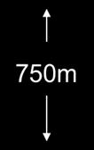
4 3 reasons to choose Quantec 1. Reliable Proven record of client successes Improved drill planning 2. Safe High standards and safe record 3. Accurate Most advanced technology Improved drill success 750m 750m depth is routine with Quantec

5 Reliable Multinational provider Advanced, deep exploration technologies: TITAN 24, ORION 3D and SPARTAN MT Gravity, magnetics, CSAMT, TDEM and VLF surveys Over 5,000 projects completed in over 50 countries


6 Committed to Safety Safety HSE management system Full-time HSE specialist Member of ISNetworld & GGSSA Insured with Chartis Pre-field risk assessment Training (First Aid, WHMIS, driving, ATV, worker HSE awareness training, etc.) Experience Our safe operations keep our most demanding clients happy. We operate safely for Junior Explorers and are approved operators for Major Mining companies like Rio Tinto, BHP and AREVA.
 3D Imaging complete 3D data acquisition for complex environments providing accurate surface to depth imaging of Resistivity, IP and MT Flexible 2D and 3D")
, TEM (surface and borehole), Max-Min,")
7 Accurate - Technology and Services World Leading Deep Exploration Technology 2D Deep earth imaging distributed data acquisition of multiparameter geophysics: Resistivity, IP and broad band magnetotellurics (MT resistivity) 3D Imaging complete 3D data acquisition for complex environments providing accurate surface to depth imaging of Resistivity, IP and MT Flexible 2D and 3D deep resistivity imaging utilizing high resolution 24-bit MT Broad Range of Expertise and Services Survey design, planning, acquisition, QA/QC, interpretation, data integration and consulting services Complete suite of conventional ground geophysical surveys including; gravity, magnetic, radiometric, IP (surface and borehole), TEM (surface and borehole), Max-Min, CSAMT and VLF
8 World Leaders in Ground Geophysics Deep Innovation Since 2002

9 Quantec Technology 2D Distributed Array DCIP & MT Deep high resolution imaging Full 3D Data Acquisition of DCIP & MT High Resolution MT Complex deep surface to depth environments Shallow to deep resistivity surveys Full Service Geophysics Multiple applications

10 TITAN 24 DCIP & MT


11 TITAN 24 Distributed multi-parameter data acquisition Penetrates deeper than conventional geophysics DC Resistivity, IP, MT Depth of investigation to 700-1,500 m Well-established in the industry 15 Years Over 400 surveys Effective for exploration in mine site environments 60 surveys


12 What is TITAN 24 DCIP & MT? A real-time distributed array system Multiple source-receiver combinations sampled simultaneously Multiple redundancy resulting in high density data sets Higher data density Current monitor, real time quality control Easily configured into standard DCIP source-receiver arrays (i.e. Pole- Dipole, Dipole-Dipole, Centre Pole, etc.) Time-series data acquisition: Application of digital signal processing software Full time series recorded, not discrete windows, therefore more complete data acquisition 24-bit sigma-delta filtering Accurately measure very small voltages


 > 5-10 km B y B x >20 km")
13 TITAN 24 distributed acquisition system layout - Typical station set up Multi channel acquisition module Battery Standard line length is 2400m Current electrode (mobile) Dipole variable from 50 to 400 metres 100m Cross-line potential electrode (fixed) In-line potential electrode (fixed) 100m LAN link to Data harvesting centre On line magnetometer site B y B x 100m 2 channel AM 1 channel AM This example: line length: 2400 m 24 E x 100m dipoles 12 E y 100m dipoles 25 current stations 2 B x /B y magnetometer sites Infinity current electrode (fixed) > 5-10 km B y B x >20 km from line Remote magnetometer site


14 The impact on exploration? Thorough, accurate imaging for improved drill planning Detection of deeper, more subtle geophysical responses Imaging through deep overburden conditions Surveying in high noise environments (active mining operations) Decreases the chance that the big one will be missed Decreases overall exploration cost by providing better targeting information Broad industry use: VMS, porphyry, gold, silver, copper Nickel, PGE s, IOCG, uranium, diamonds Minesite Geothermal and Hydrocarbons


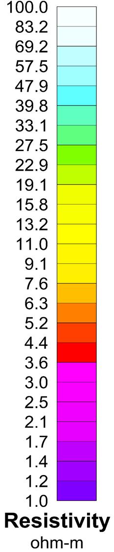
15 Deep multi-parameter information Top panel: MT Resistivity PW 2D inversion; Typically 1500 metres Middle panel: DC Resistivity UBC smooth inversion; Typically metres Bottom panel: Chargeability UBC smooth inversion.


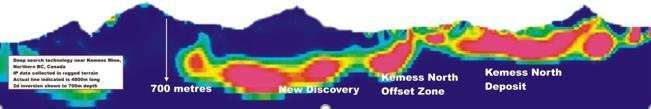
16 17 years of proven success Copper Mtn Kemess
17 Some TITAN clients Barrick Gold Corp. Noranda/Falconbridg e Inc. Placer Dome Inc. Tribute Minerals Inc. Barker Minerals Inc. The O.T. Mining Corporation Lionore Mining International Ltd. De Beers Consolidated Mines Limited Apollo Gold Corporation NADR Corporation Kennecott Exploration Company Cameco Corporation Ontzinc Corporation Goldcorp Inc. Newmont Mining Corporation Wallbridge Mining Company Limited Inco Limited Dept. of Energy (Nevada) FNX Mining Company Inc. Kennecott Exploration Company Cameco Corporation Ontzinc Corporation Goldcorp Inc. Newmont Mining Corporation Wallbridge Mining Company Limited Inco Limited Dept. of Energy (Nevada) FNX Mining Company Inc. Breakwater Resources New Gold MILPO Almaden Minerals New Nadina Explorations Mining Ventures Brazil Denison Mines Malbex Resources Areva Resources Northland Resources Inmet Mining Boxxer Gold Copper Mountain Mining Corp. Ormat Technologies Huckleberry Mines Castillian Resources Vale Argentina Romios Gold Resources Northern Freegold Xstrata Copper Rosemont Copper Regulus Resources Agnico-Eagle Mines Kazakhmys Exploration


18 Mine site applications with TITAN 24 Mine Planning Ground investigations pre tailings Ground condemnation Monitoring Delineate Resource mapping, extensions and discover new ore Explore At mine sites and near mine exploration

19 High volume data allows windowing: needed to minimize cultural noise


20 Experience at over 60 minesites Some of our mine site clients Copper Mountain Tenke Fungurume Kidd Creek Tati Nickel Raglan Ren Red Lake Gold Mine Geikle Voisey s Bay Levack San Nicolas Black Fox Gold Mine Fortitude Chelopech Borroo Red Chris
21 ORION 3D DCIP & MT World Leaders in Deep Innovation Since 2002


22 ORION 3D DCIP & MT surveys Accurate imaging for complex environments Depth of investigation to 1,500 m for Resistivity, 750m for IP Confidence in interpretation True 3D acquisition Omni-directional simultaneous sampling Multi-parameter DC Resistivity, IP, MT

23 ORION 3D layout Receiver dipole Data recorder Current injection Conceptual current path o o o True 3D DCIP measurement Simultaneous receiver sampling Omnidirectional data free from receiver geometry bias


24 ORION for best possible drill planning Survey flexibility Distributed acquisition allows for customization of the survey layout 3D geometry The survey samples local geology from all directions simultaneously High signal-to-noise ratio Low-noise electronics ensure high quality data Depth penetration Large-offset data acquisition ensures maximum depth penetration High resolution High data volume boosts the resolution of the survey and supports confident and accurate interpretations Yields best representation of the subsurface for drill planning Layout Planned Coverage Results Targets

25 Sampling everything (from all directions) 2D Data 3D Data More than 140,000 samples Omni-directional sampling for unparalleled definition in complex environments

 UC Model")

26 ORION results Looking North (Az 360 o Inc 25 o ) UC Model WS conductor with Phoenix drilling


27 ORION results Image Before drilling Save Money Survey says DON T DRILL HERE Mineralization inside geophysical target

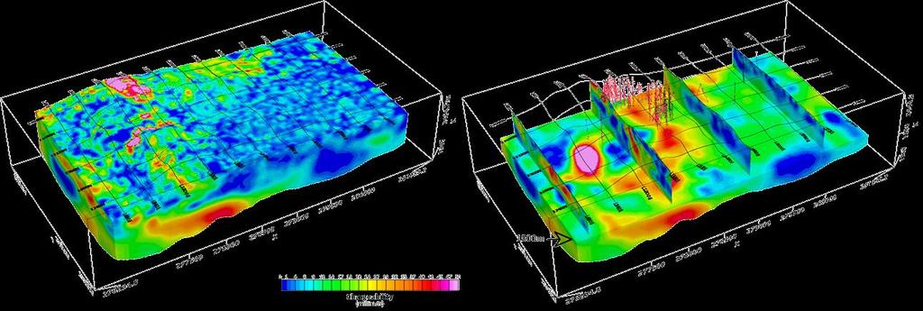
28 Orion 3D South Grid IP chargeability model
29 SPARTAN MT full tensor magnetotellurics

30 MT natural source fields Lower frequencies: f < 1 Hz Interaction of the solar wind with the earth s magnetic field Higher frequencies: f > 1 Hz Global lightning activity Thunderstorms

31 SPARTAN MT applications Deep terrain-scale structural mapping Regional potential target evaluation Targeting of TITAN surveys Basin mapping (depth of cover) Crustal studies Geothermal exploration- effective at mapping structures, cap rock, and reservoir morphology. Oil & gas exploration - augment ambiguous seismic results. Volcanic cover and permafrost can limit the effectiveness of seismic data. SPARTAN MT readily penetrates through this type of geology. For best results, SPARTAN data should be integrated with other data types to develop a whole earth model.


32 SPARTAN MT results Regional study, USA, depth to top 10 km Portable, excellent tool for remote imaging, example geothermal exploration (4km depth)


33 SPARTAN MT SURVEY PLAN 14 KM 12 KM

34 3D Resistivity Inversion Model


35 Iso shells depicting low resistivity (volcanics

36 2D Resistivity Section through 3D model

37 MT survey utilising nominal 700 metres Volcano


38 3D Inversion
39 Resistivity plan view at 200m depth
40 Geophysical services

41 Geophysical services - surveys
42 Consulting and interpretive services Registered Professional Geophysicists Enhancement of old data Reprocessing, reinversion, integration of different data sets Survey planning and design Integrated interpretations Geophysical Modelling Targeting

43 Thank you!
Quantec s ORION 3D System Application and Examples
 Quantec s ORION 3D System Application and Examples Warren W. Stanyer David Thomson Michele Tuomi Roger Sharpe*, Kevin Killin Nevada Sunrise Cerro Grande Mining Landore Resources Canada Quantec Geoscience
MT Prospecting. Map Resistivity. Determine Formations. Determine Structure. Targeted Drilling
 MT Prospecting Map Resistivity Determine Formations Determine Structure Targeted Drilling Cross-sectional interpretation before and after an MT survey of a mineral exploration prospect containing volcanic
CORPORATE PROFILE Airborne Geophysics for Mineral Exploration
 CORPORATE PROFILE Airborne Geophysics for Mineral Exploration Highlights Specialists in high resolution airborne geophysical surveys in mountainous terrain Precision GeoSurveys is a full-service airborne
EXTREMELY FAST IP USED TO DELINEATE BURIED LANDFILLS. Norman R. Carlson, Cris Mauldin Mayerle, and Kenneth L. Zonge
 EXTREMELY FAST IP USED TO DELINEATE BURIED LANDFILLS Norman R. Carlson, Cris Mauldin Mayerle, and Kenneth L. Zonge Zonge Engineering and Research Organization, Inc. 3322 East Fort Lowell Road Tucson, Arizona,
An Integrated 3D Approach to Deep Search Exploration
 Advances in 3D Visualization and Data Integration An Integrated 3D Approach to Deep Search Exploration 1. Geophysicist, Director of Marketing, Quantec Geoscience Ltd. Paper 38 Gordon, R. L. [1] ABSTRACT
Applied Geophysics for Environmental Site Characterization and Remediation
 Applied Geophysics for Environmental Site Characterization and Remediation MSECA Webinar September 24, 2015 John Mundell, P.E., L.P.G. Ryan Brumbaugh, L.P.G. MUNDELL & ASSOCIATES, INC. Webinar Objective
An Integrated 3D Approach to Deep Search Exploration
 An Integrated 3D Approach to Deep Search Exploration Gordon, R.L. [1] 1. R.L. Gordon, Geophysicist, Director of Marketing, Quantec Geoscience Ltd. ABSTRACT Advances in various technologies continue to
Our Services. What We Do. How We Can Help. Contact us today: January (0)
") Listening and Understanding to Optimize our Efficiency Our Experience and Knowledge to Work for You Tailor-made Solutions to Meet your Needs Our Challenge is You Success What We Do Our Services GeoViz
Listening and Understanding to Optimize our Efficiency Our Experience and Knowledge to Work for You Tailor-made Solutions to Meet your Needs Our Challenge is You Success What We Do Our Services GeoViz
GEOTECH: Airborne Geophysics and Its Possible Application in Bulgaria. Prof. Alexander Antonov, Canada
 GEOTECH: Airborne Geophysics and Its Possible Application in Bulgaria Prof. Alexander Antonov, Canada Geotech overview Geotech Ltd is a global leader in airborne geophysical survey, mapping, interpretation
Western EARS Geothermal Geophysics Context Mar-2016 William Cumming
 Western EARS Geothermal Geophysics Context Mar-2016 William Cumming Cumming Geoscience, Santa Rosa CA wcumming@wcumming.com Office: +1-707-546-1245 Mobile: +1-707-483-7959 Skype: wcumming.com Kibiro Geophysics
UTEM Electric Field Measurements
 UTEM Electric Field Measurements first measurements by Y. Lamontagne ~1975 (U of T) Ph.D. studies (U of T) by J. Macnae confirmed the method ISR evolved ~ 1986 for gold exploration (sillicification) clients
Geophysics Course Introduction to DC Resistivity
 NORAD supported project in MRRD covering Capacity Building and Institutional Cooperation in the field of Hydrogeology for Faryab Province Afghanistan Geophysics Course Introduction to DC Resistivity By
MOUNT POLLEY MINING CORPORATION TECHNICAL REPORT ON MULTI-ELECTRODE RESISTIVITY AND SEISMIC REFRACTION SURVEYS MOUNT POLLEY TAILINGS DAM PROJECT
 MOUNT PLEY MINING CORPORATION TECHNICAL REPORT ON MULTI-ELECTRODE RESISTIVITY AND SEISMIC REFRACTION SURVEYS MOUNT PLEY TAILINGS DAM PROJECT LIKELY, B.C. by Claudia Krumbiegel, M.Sc. Cliff Candy, P.Geo.
Geophysical Survey Interpretation Report
 116 Spadina Ave., Suite 400 Toronto, ON, M5V 2K6 Phone (416) 306 1941 Fax (416) 306 1949 Geophysical Survey Interpretation Report Quantec Titan-24 Distributed Acquisition System DC RESISTIVITY & INDUCED
Integrated Geophysical Model for Suswa Geothermal Prospect using Resistivity, Seismics and Gravity Survey Data in Kenya
 Proceedings World Geothermal Congress 2015 Melbourne, Australia, 19-25 April 2015 Integrated Geophysical Model for Suswa Geothermal Prospect using Resistivity, Seismics and Gravity Survey Data in Kenya
Geophysical Exploration in Water Resources Assessment. John Mundell, P.E., L.P.G., P.G. Ryan Brumbaugh, L.P.G. Mundell & Associates, Inc.
 Geophysical Exploration in Water Resources Assessment John Mundell, P.E., L.P.G., P.G. Ryan Brumbaugh, L.P.G. Mundell & Associates, Inc. Presentation Objective Introduce the use of geophysical survey methods
National Geophysical Survey Science Opportunities
 National Geophysical Survey Science Opportunities Anton Ziolkowski Professor of Petroleum Geoscience University of Edinburgh BGS Keyworth 4 April 2016 Outline Brief biography Science opportunities High
The Future is Under Cover
 The Future is Under Cover TSX.V: NGE OTCQX: NVDEF Disclaimer This Presentation contains certain "forward-looking statements" including, without limitation, expectations, beliefs, plans and objectives regarding
Introducing the Stratagem EH4. Electrical Conductivity Imaging System Hybrid-Source Magnetotellurics
 Introducing the Stratagem EH4 Electrical Conductivity Imaging System Hybrid-Source Magnetotellurics Stratagem EH4 Hybrid-Source Magnetotellurics Frequency range of 10 Hz to 90k Hz Approx. depth of investigation
GROUND ACOUSTIC PENETRATION
 GROUND ACOUSTIC PENETRATION Bronislav A. Koulmametiev and Boris V. Matveev InterGeoRAP Consulting. 8 Hartleap Lane, Beldon, WA 6027. E-mail: tchern@iinet.net.au 1. DESCRIPTION Ground Acoustic Penetration
IVANHOE MINES EXTENDS HUGO NORTH GEOPHYSICAL ANOMALY FOUR KILOMETRES NORTH ADDITIONAL GEOPHYSICAL TARGETS IDENTIFIED
 December 6, 2004 IVANHOE MINES EXTENDS HUGO NORTH GEOPHYSICAL ANOMALY FOUR KILOMETRES NORTH ADDITIONAL GEOPHYSICAL TARGETS IDENTIFIED ULAANBAATAR, MONGOLIA Ivanhoe Mines Chairman Robert Friedland, Deputy
Australia s Mineral Resources: A New Era of Exploration and Development
 Australia s Mineral Resources: A New Era of Exploration and Development Dr James Johnson Chief Onshore Energy and Minerals Division Geoscience Australia Australia s Mineral Production and Endowment Commodity
For personal use only
 22 April 2013 Drilling to commence at Majada, Copper-Gold Prospect, Chile. Red Gum Resources Limited (ASX: RGX, Red Gum or the Company ) is pleased to announce that drilling of its Majada Copper-Gold Prospect,
Melkior Drills Shallow Holes on Zam Zam and Jowsey Gold Zones and Intersects 33.1 g/t over 1.18 Metres
 Melkior Drills Shallow Holes on Zam Zam and Jowsey Gold Zones and Intersects 33.1 g/t over 1.18 Metres July 26, 2016 Trading Symbol: MKR TSX Venture Exchange Ottawa, Ontario. Melkior Resources Inc. ( Melkior
Wellsite Consulting Services Diversified Well Logging LLC. All Rights Reserved.
 Wellsite Consulting Services We are CUSTOMER FOCUSED: We seek to exceed customer expectations by providing solutions that improve their drilling, completions, and production economics OUR CORE VALUES DEFINE
Geophysical, Geological and Environmental Services
 Geophysical, Geological and Environmental Services Experience KAZAKHSTAN MOLDOVA CROATIA SERBIA ROMANIA MONTENEGRO BULGARIA F.Y.R.O.M. ALBANIA ARMENIA PORTUGAL GREECE TURKEY SYRIA IRAN AFGHANISTAN MOROCCO
Petroleum Exploration
 Petroleum Exploration Upstream Petroleum Exploration The role of exploration is to provide the information required to exploit the best opportunities presented in the choice of areas, and to manage research
The Discovery of the Phoenix: New High-Grade, Athabasca Basin Unconformity Uranium Deposits Saskatchewan, Canada
 The Discovery of the Phoenix: New High-Grade, Athabasca Basin Unconformity Uranium Deposits Saskatchewan, Canada FORWARD LOOKING STATEMENT Some disclosure included in this presentation respecting production,
Preliminary Mineral Exploration on the Pickett Mountain Property T6R6 WELS, Penobscot County, Maine. Public Information Session December 5, 2017
 Preliminary Mineral Exploration on the Pickett Mountain Property T6R6 WELS, Penobscot County, Maine Public Information Session December 5, 2017 Outline of Presentation Wolfden Resources Corporation Who
Geophysics foundations: Seeing underground: Introduction
 Introduction Outline This five page article was written for those involved in the earth sciences who have no background in geophysics. It is intended to explain very briefly how applied geophysics can
3D MAGNETOTELLURIC SURVEY AT THE YANAIZU-NISHIYAMA GEOTHERMAL FIELD, NORTHERN JAPAN
 3D MAGNETOTELLURIC SURVEY AT THE YANAIZU-NISHIYAMA GEOTHERMAL FIELD, NORTHERN JAPAN Toshihiro Uchida 1, Shinichi Takakura 1, Takumi Ueda 1, Masaho Adachi 2, Hitoshi Ozeki 2, Kunikazu Kamada 3, Tatsuya
High Resolution Seismic for Minerals
 High Resolution Seismic for Minerals Greg Turner HiSeis Pty Ltd MEGWA April 2013 WELCOME HiSeis Pty Ltd, Suite 4 Enterprise Unit 3, 9 DeLaeter Way, Bentley, WA 6102 Ph: +61 8 9470 9866 www.hiseis.com Used
Main Menu. Douglas Oldenburg University of British Columbia Vancouver, BC, Canada
 Using ERA low frequency E-field profiling and UBC 3D frequency-domain inversion to delineate and discover a mineralized zone in Porcupine district, Ontario, Canada. Vlad Kaminski* University of British
The Romero Copper-Gold Discovery Dominican Republic
 The Romero Copper-Gold Discovery Dominican Republic December 2012 1 GoldQuestCorp.com Forward Looking Statements Statements in this document, to the extent not based on historical events, constitute forward-looking
Geothermal Energy Resources Exploration using Gravity and magnetics. By Mariita, N.O. KenGen
 Geothermal Energy Resources Exploration using Gravity and magnetics By Mariita, N.O. KenGen What is Geothermal Energy? Geothermal Energy = heat from the Earth Transmitted by fluids via fractures and pores
Professional Geologist Wyoming PG-497 SME Registered Member Member--AIPG
 , PH.D., P.G. Institute for Mining Geology Principal Consulting Geologist ADDRESS 14492 West 70 th Place Arvada, CO 80004 303-423-6570 (Home) 303-868-7061 (cell) thomasbidgood@mininggeology.org EXPERTISE
TSX-V NNA
 New Nadina Explorations Limited 1215 Greenwood Street, Greenwood, BC V0H 1J0 Office: 250-445-2260 Ellen Clements: 250-444-1005 Feature Silver Queen Project 1 12S-05 Core from Vein intercept DDH 12S-05
Project 81. Drill Ready Geophysical Targets & Trends. Timmins-Cochrane Northern Ontario Canada
 Project 81 Drill Ready Geophysical Targets & Trends Timmins-Cochrane Northern Ontario Canada FORWARD-LOOKING STATEMENT Certain statements contained in this presentation that are forwardlooking in nature
CanAlaska Ventures Ltd
 www.canalaska.com This slide show presentation contains certain "Forward-Looking Statements" within the meaning of Section 21E of the United States Securities Exchange Act of 1934, as amended. All statements,
indigeo Consultants Pvt Ltd Geophysical Surveys Geological Surveys GIS & Data Solutions Image Processing indigeo Company Profile, Page 1
 indigeo Consultants Pvt Ltd Geophysical Surveys Geological Surveys GIS & Data Solutions Image Processing MM Corner, 3 rd Floor #58, Banaswadi Main Road Bangalore 560033 INDIA Ph: +91 80 41638310 Mob: +91
Marine Geophysical Methods: What Can and Cannot Be Done to Iden8fy Hazards to Dredging & Marine Construc8on
 Marine Geophysical Methods: What Can and Cannot Be Done to Iden8fy Hazards to Dredging & Marine Construc8on Marine Geophysics Sham or Savior? Seen alternatively as the silver bullet or snake oil, marine
Magnetotelluric (MT) Method
 Method") Magnetotelluric (MT) Method Dr. Hendra Grandis Graduate Program in Applied Geophysics Faculty of Mining and Petroleum Engineering ITB Geophysical Methods Techniques applying physical laws (or theory) to
Magnetotelluric (MT) Method Dr. Hendra Grandis Graduate Program in Applied Geophysics Faculty of Mining and Petroleum Engineering ITB Geophysical Methods Techniques applying physical laws (or theory) to
Identified a possible new offset location where the customer is currently exploring drill options.
 GroundMetrics was hired to conduct a Full-Field Resistivity Survey for an oil and gas producer that needed to make crucial decisions to drive profitability at the location. The results saved them hundreds
ASX Code: ORN Compelling Nickel-Copper Targets Defined at Fraser Range Project
 ASX Code: ORN www.oriongold.com.au Compelling Nickel-Copper Targets Defined at Fraser Range Project 1 Disclaimer and Forward-Looking Statements Certain statements contained in this presentation, including
ONGAVA POLY-METALLIC PROJECT
 27 April 2010 QUARTERLY ACTIVITIES REPORT for the period ended 31 March 2010 ONGAVA POLY-METALLIC PROJECT Diamond drilling is underway at Border. Extensive geophysical surveys were completed at Border
Exploration of Geothermal High Enthalpy Resources using Magnetotellurics an Example from Chile
 Exploration of Geothermal High Enthalpy Resources using Magnetotellurics an Example from Chile Ulrich Kalberkamp, Federal Institute for Geosciences and Natural Resources (BGR), Stilleweg 2, 30655 Hannover,
Discovering the Earth s Resources. Geophysical, Geological and Environmental Services
 Geophysical, Geological and Environmental Services Services Overview Prospectiuni SA is the leading geophysical and geological service company in South Eastern Europe with 60 years of experience of international
Alligator Energy Uranium Projects. 6 September 18 NT RESOURCES WEEK Greg Hall, CEO
 Alligator Energy Uranium Projects 6 September 18 NT RESOURCES WEEK Greg Hall, CEO Disclaimer & Competent Person s Statement 2 Disclaimer This presentation contains projections and forward looking information
ASX ANNOUNCEMENT 4 March 2019 VTEM SURVEY COMMENCED OVER LORRAINE AND ADZ PROJECT AREAS
 ASX ANNOUNCEMENT 4 March 2019 VTEM SURVEY COMMENCED OVER LORRAINE AND ADZ PROJECT AREAS The Company is pleased to announce the commencement of a detailed airborne electromagnetic geophysical survey over
In the past century, prospectors discovered
 FEATURE Instrumentation GDD Inc. s Beep Map Is prospecting dead? By Edwin Gaucher, Eng., Ph.D. and Pierre Gaucher, Eng., MBA In the past century, prospectors discovered many mines while examining shorelines
Valuation Early Stage Exploration Projects
 Valuation Early Stage Exploration Projects Presented By: Tracey Laight Date: 20 January 2016 Location: AMA London SRK Exploration Services Ltd 2016. All rights reserved. Everything has a value Every project
GEOMATICS SURVEYING AND MAPPING EXPERTS FOR OVER 35 YEARS
 GEOMATICS SURVEYING AND MAPPING EXPERTS FOR OVER 35 YEARS 2 GEOMATICS AND SURVEYING SOLUTIONS SPANNING THE ENTIRE PROJECT LIFECYCLE 1,000+ 250+ 24 Surveying professionals Active field crews Geomatics offices
ADVANCING A PROSPECTIVE PORTFOLIO TO DISCOVERY SUCCESS. Copper - Gold - Silver SAN VALENTINO. COPPER-GOLD-MOLY Northern Chile.
 ADVANCING A PROSPECTIVE PORTFOLIO TO DISCOVERY SUCCESS Copper - Gold - Silver SAN VALENTINO COPPER-GOLD-MOLY Northern Chile Project Summary March 2018 Cautionary Statement Certain statements contained
UPDATE ON DRILLING TO BE CONDUCTED AT AURORA TANK GOLD PROJECT
 ASX ANNOUNCEMENT 1 April 2015 UPDATE ON DRILLING TO BE CONDUCTED AT AURORA TANK GOLD PROJECT Attached for shareholders information, is an announcement made to the market by Apollo Minerals Limited (ASX:
Geophysics and Mapping. presented by: Stephen Brown
 Geophysics and Mapping presented by: Stephen Brown Recommended book for INIGEMM Geophysics for the mineral exploration geoscientist, by Michael Dentith and Stephen Mudge, Cambridge University Press, 2014.
HELIO RESOURCE CORP.
 HELIO RESOURCE CORP. Suite 800 625 Howe Street Vancouver, British Columbia V6C 2T6 Phone: (604) 668-8356 Fax: (604) 668-8366 (www.helioresource.com) NEWS RELEASE & SHAREHOLDER UPDATE September 12, 2005
Parkin Offset Properties. Sudbury, Ontario
 Parkin Offset Properties Sudbury, Ontario May 11, 2015 CAUTIONARY STATEMENT No regulatory authority has approved or disapproved the information contained in this presentation. This presentation includes
ITASCA Consulting Canada Inc.
 Forward Thinking Engineering World leaders in geomechanics, hydrogeology and microseismicity. Solving problems for clients in the mining industry. Itasca offers advanced, first-hand knowledge of mining
NexIndio. Exploring for Copper & Gold in South America Corporate Presentation
 NexIndio Exploring for Copper & Gold in South America Corporate Presentation Disclaimer NexIndio The company is focused on exploring for Copper and Gold in South America The first property is located in
Summary and status of the Reinfjord Exploration Project and other exploration targets within the Seiland Igneous Province
 Summary and status of the Reinfjord Exploration Project and other exploration targets within the Seiland Igneous Province By Nordic Mining s Exploration Manager Mona Schanche, 1 st of August 2013 Background
Revelo Defines Porphyry Copper Targets at its Calvario Project
 www.reveloresources.com NEWS RELEASE #01/2015 Revelo Defines Porphyry Copper Targets at its Calvario Project Vancouver - February 03, 2015 - Revelo Resources Corp. ( Revelo or the Company ) (TSX-V: RVL)
Northern Chile, 85 Km NE of La Serena 125 km S of Relincho (Nueva Union Teck-Goldcorp)
") July 2017 Mirador lies along the southern extensions of the highly productive Paleocene Mineral Belt in northern Chile that contains numerous important copper, gold and silver mines and projects. Mirador
July 2017 Mirador lies along the southern extensions of the highly productive Paleocene Mineral Belt in northern Chile that contains numerous important copper, gold and silver mines and projects. Mirador
LIST OF FIGURES APPENDICES
 RESISTIVITY / INDUCED POLARIZATION SURVEY EL PORVENIR PROJECT MUNICIPALITY OF REMEDIOS, ANTIOQUIA, COLOMBIA LOGISTICS REPORT M-17427 APRIL 2017 TABLE OF CONTENTS Abstract... 1 1. The Mandate... 2 2. El
Geophysics. Geotechnics. Geophysics. Earthworks. Environment. Groundwater. Rock Mechanics. Integrated Practical Solutions
 Geophysics Geotechnics Environment Groundwater Rock Mechanics Geophysics Earthworks Integrated Practical Solutions Geophysics Services Our 50 years of experience gained over 100,000 completed projects,
Mt Carlton Project Discovery of the Silver Hill Gold-Silver-Copper Deposit SMEDG Mines and Wines September 2007
 0 Mt Carlton Project Discovery of the Silver Hill Gold-Silver-Copper Deposit SMEDG Mines and Wines September 2007 Building and Growing a profitable Mining and Exploration Company within Australia. Mount
September 16, 2010 Magnetic surveying
 September 16, 2010 Magnetic surveying After today, you will be able to Sketch anomalies over objects at any location, and explain how you derived the pattern. Explain the relation between dipoles and real
For personal use only
 INTEGRATED RESOURCES GROUP LIMITED REPORT ON ACTIVITIES, MARCH 2012 QUARTER HIGHLIGHTS Announcement of company transforming Maryborough Basin project acquisition, expected to be completed in June 2012.
Silver City Minerals
 ABN 68 130 933 309 ASX Code: SCI Silver City Minerals Annual General Meeting 15 November 2016 1 Important Disclaimer This presentation is provided to you for the sole purpose of providing background technical,
Project Development in Argentina. For Wind Energy and Minerals Using Spatial Data Modelling
 Project Development in Argentina For Wind Energy and Minerals Using Spatial Data Modelling Introduction Development of New Business Opportunities in Argentina Key Project for Kenex Since Mining 2010. Based
MEMORANDUM. Interpretation of Magnetic and Volterra-3DIP survey MC Claims
 11966 95A Avenue, Delta, BC V4C 3W2 Canada Tel +1 (604) 582-1100 www.sjgeophysics.com MEMORANDUM Date: September 13, 2017 From: To: SUBJECT: E. Trent Pezzot Bonanza Mining Corporation Interpretation of
POTASH DRAGON CHILE GEOPHYSICAL SURVEY TRANSIENT ELECTROMAGNETIC (TEM) METHOD. LLAMARA and SOLIDA PROJECTS SALAR DE LLAMARA, IQUIQUE, REGION I, CHILE
 METHOD. LLAMARA and SOLIDA PROJECTS SALAR DE LLAMARA, IQUIQUE, REGION I, CHILE") POTASH DRAGON CHILE GEOPHYSICAL SURVEY TRANSIENT ELECTROMAGNETIC (TEM) METHOD LLAMARA and SOLIDA PROJECTS SALAR DE LLAMARA, IQUIQUE, REGION I, CHILE OCTOBER 2012 CONTENT Page I INTRODUCTION 1 II FIELD
POTASH DRAGON CHILE GEOPHYSICAL SURVEY TRANSIENT ELECTROMAGNETIC (TEM) METHOD LLAMARA and SOLIDA PROJECTS SALAR DE LLAMARA, IQUIQUE, REGION I, CHILE OCTOBER 2012 CONTENT Page I INTRODUCTION 1 II FIELD
First on the Ground. Geomatics
 First on the Ground Geomatics Surveying and mapping solutions spanning the entire project lifecycle Part art, part science, part technology, the Geomatics profession is constantly evolving. From the very
Mineral Discoveries Using Big Data Analytics: Azimut s Exploration Edge
 Mineral Discoveries Using Big Data Analytics: Azimut s Exploration Edge Jean-Marc Lulin, PhD, P.Geo. Sprott Natural Resource Symposium July 2017 Azimut: Big Data Analytics in Exploration 1) Why use Big
ASX Announcement. FLEM survey underway at Henrietta Cobalt Nickel Prospect, Tasmania ASX: AX8 HIGHLIGHTS. Market Data. Board and Management.
 FLEM survey underway at Henrietta Cobalt Nickel Prospect, Tasmania ASX Announcement Market Data ASX Code: AX8 Shares on Issue: 47,620,000 Board and Management Grant Mooney Non-Executive Chairman Andrew
APPENDIX A: Magnetotelluric Data in Relation to San Pedro Mesa Structural. The San Pedro Mesa structural high (discussed in main text of paper) was
 was") Page of DR for GSA Special Paper 9, Chapter, Geophysical constraints APPENDIX A: Magnetotelluric Data in Relation to San Pedro Mesa Structural High The San Pedro Mesa structural high (discussed in main
Page of DR for GSA Special Paper 9, Chapter, Geophysical constraints APPENDIX A: Magnetotelluric Data in Relation to San Pedro Mesa Structural High The San Pedro Mesa structural high (discussed in main
SUPPLEMENTARY INFORMATION
 SUPPLEMENTARY INFORMATION Supplementary online material for Bai et al., (2). EHS3D MT data collection Broadband magnetotelluric (MT) data were recorded on profiles P, P2 and P4 in the frequency band -.5
Kiska Metals Corporation Project Updates
 Kiska Metals Corporation Project Updates Minerals North Conference, Mackenzie BC May 28, 2015 Kelly Franz, P.Geo Manager, Lands and Corporate Social Responsibility Cautionary Note This presentation contains
Mirasol Outlines 1.4 km long Geophysical Anomaly at the Resolution Trend of the Nico Ag-Au Project, Santa Cruz, Argentina
 NEWS RELEASE Mirasol Outlines 1.4 km long Geophysical Anomaly at the Resolution Trend of the Nico Ag-Au Project, Santa Cruz, Argentina VANCOUVER, BC July 5, 2018 Mirasol Resources Ltd. (TSXV: MRZ), (OTCPK:
An Introduction to Geophysical Exploration
 An Introduction to Geophysical Exploration Philip Kearey Department of Earth Sciences University of Bristol Michael Brooks Ty Newydd, City Near Cowbridge Vale of Glamorgan Ian Hill Department of Geology
Corporate Presentation ORFORD MINING. March 2017
 Orford True North Mining Nickel Corporate Presentation ORFORD MINING March 2017 Cautionary Statements Concerning Forward-Looking Statements This presentation contains "forward-looking information" including
CONTENTS 1. INTRODUCTION. 2. THE D.C. RESISTIVITY METHOD 2.1 Equipment 2.2 Survey Procedure 2.3 Data Reduction
 (i) CONTENTS 1. INTRODUCTION page 1 2. THE D.C. RESISTIVITY METHOD 2.1 Equipment 2.2 Survey Procedure 2.3 Data Reduction 3 3 3 3 3. GEOPHYSICAL RESULTS 3.1 General 3.2 Discussion 4 4 4 4. LIMITATIONS 5
Yukon Presentation. October 2012
 Yukon Presentation October 2012 Disclaimer This presentation contains forward looking statements. All statements, other than statements of historical fact, included herein, including without limitation,
B7 Applications of DC resistivity exploration
 B7 Applications of DC resistivity exploration Modern DC resistivity surveys collect data for generating a 2-D or 3-D geoelectric model of the Earth. A simple 1-D analysis does not often yield results that
3,000 metre Diamond Drilling Program Underway at Big Ranch Copper Prospect
 10 October 2018 ASX RELEASE 3,000 metre Diamond Drilling Program Underway at Big Ranch Copper Prospect ASX: AGR Highlights: Initial drill program will take three months scout drilling to define best area
Landmark Farm-in and JV Agreement with Rio Tinto to Underpin Accelerated Nickel-Copper Exploration
 14 May 2018 Page 1 of 5 Kitgum Pader Base Metals Project, Northern Uganda Landmark Farm-in and JV Agreement with Rio Tinto to Underpin Accelerated Nickel-Copper Exploration Rio Tinto can fund up to US$57M
For Immediate Release May 21, 2002
 For Immediate Release May 21, 2002 IMPORTANT NEW COPPER AND GOLD DISCOVERY EXPANDS CENTRAL ZONE AT TURQUOISE HILL GOLD AND COPPER PROJECT IN MONGOLIA; CONTRACT SIGNED TO EXPAND DRILLING PROGRAM MONGOLIA
Peter Williams,Anton Kepic, and Milovan Urosevic. HiSeis Pty Ltd and Curtin University of Technology Western Australia
 Peter Williams,Anton Kepic, and Milovan Urosevic HiSeis Pty Ltd and Curtin University of Technology Western Australia Brownfields/In-Mine Geophysics? Theme 1: Using holes better (getting more relevant
Seismoelectric Ground-flow DC-4500 Locator
 Seismoelectric Ground-flow DC-4500 Locator Introduction The seismoelectric survey is a new technology combined the electro kinetic potential method and geophysical technology. It is applied directly to
November, Vulcan Minerals Overview
 November, 2018 Vulcan Minerals Overview Forward Looking Statements This presentation may include forward looking statements. All statements, other than statements of historical fact, included herein, including
Interpretation Report on Borehole TDEM Surveys
 Interpretation Report on Borehole TDEM Surveys Junior Lake Property, Armstrong, Ontario For Landore Resources Canada Inc. Alan R. King, M.Sc., P.Geo. January 25, 2016 Introduction Alan King of Geoscience
international geophysical services
 international geophysical services Prospectiuni Facts & Figures 65 years and still growing Experience in 38 countries, with operations in 8 to 10 countries each year No. 1 geological and geophysical services
Press kit Kartotrak 2014 June 2nd, 2014
 Press kit Kartotrak 2014 June 2nd, 2014 Worldwide leader in Geostatistics, Geovariances enables its clients involved with mapping, resource estimation or risk analysis to benefit from more than 25 years
Sabin Zn-Cu VMS Project. Sturgeon Lake Belt, Ontario
 Sabin Zn-Cu VMS Project Sturgeon Lake Belt, Ontario June 2017 CORPORATE DISCLOSURE Disclaimer The information contained herein, while obtained from sources which we believe are reliable, is not guaranteed
JAN FEB MAR APR MAY JUN JUL AUG SEP OCT NOV DEC DRILL CORE WEEKLY VOLUME 7. Wayne Hewgill, P. Geo Research Analyst
 JAN FEB MAR APR MAY JUN JUL AUG SEP OCT NOV DEC DRILL CORE WEEKLY VOLUME 7 01 02 03 04 05 06 07 08 09 10 11 12 13 14 15 16 17 18 19 20 21 22 23 24 25 26 27 28 29 30 31 Drill Core Weekly highlights drilling
With improved metal prices and utilizing new technology past producing copper gold mines are being re started by new owners
 With improved metal prices and utilizing new technology past producing copper gold mines are being re started by new owners Re starting the Phoenix copper gold mine British Columbia, Canada 1 Overview
July Exploring for Canadian Gold in the Rainy River District of Ontario
 July 2013 Exploring for Canadian Gold in the Rainy River District of Ontario 1 Forward Looking Statements Some of the statements in this document may be deemed to be "forward-looking statements". All statements
McElroy Bryan Geological Services. Consulting Geologists since 1970 CORPORATE PROFILE
 McElroy Bryan Geological Services Consulting Geologists since 1970 CORPORATE PROFILE WHO WE ARE McElroy Bryan Geological Services (MBGS) is a group of professional geologists providing specialist consulting
Early Exploration Plan Activity Information
 Early Exploration Plan Activity Information Activities That Require an Early Exploration Plan: Line cutting that is a width of 1.5 metres or less; Geophysical surveys on the ground requiring the use of
We are committed to providing accessible customer service. If you need accessible formats or communications supports, please contact us.
 We are committed to providing accessible customer service. If you need accessible formats or communications supports, please contact us. Nous tenons à améliorer l accessibilité des services à la clientèle.
For personal use only
 ASX RELEASE DATE 21 AUGUST 2018 TECHNICAL PRESENTATION Alice Queen Limited (the Company) advises that a recording of an investor webinar held today at 1pm (AEST) regarding the attached Technical Presentation