Western EARS Geothermal Geophysics Context Mar-2016 William Cumming
|
|
|
- Janis Crawford
- 5 years ago
- Views:
Transcription

1 Western EARS Geothermal Geophysics Context Mar-2016 William Cumming Cumming Geoscience, Santa Rosa CA Office: Mobile: Skype: wcumming.com
2 Kibiro Geophysics Geothermal Resource Assessment Requires Consistent Geoscience Context Context Issues Worldwide Sumatra and Philippines - arc andesite volcanics BUT oblique subduction so many fields at step-overs in strike-slip faults, NOT at big volcanoes AND most mapped faults boundaries NOT targets Eastern EARS trachyte and phonolite do not alter to smectite, modifying capping concept and MT resistivity interpretation Context Issues in Western EARS Growing Consensus: Volcanics from deep magma with little shallow residence. Heating regional not localized Growing Consensus: High CO 2 gas flux and deep structure Incomplete: Basin structure and localization of permeability Incomplete: Hydrology and permeability (+geochemistry, structure) Cumming (2016)
3 Kibiro Geophysics Mar-2016 William Cumming Cumming Geoscience, Santa Rosa CA Office: Mobile: Skype: wcumming.com
4 Kibiro Geophysics Kibiro Geophysics Review Geophysical Data Types and Results Reflection seismic illustrates structures in Lake Albert Basin adjacent to Kibiro that may source the hot water GIS and time-depth requested MT constrains 2D resistivity pattern consistent with upflow from sedimentary basin into shallow tabular onshore aquifer TEM follow up for shallow sediments and static MT Airborne gravity data available only from structural map which has been very helpful (but incomplete) Aeromagnetic survey detected intrusions younger than Proterozoic that provided important initial support for basin structure but too ambiguous in timing to infer heating Cumming (2016)
5 Kibiro Geophysics Kibiro Seismic Cross-section Reflection seismic surveys acquired for petroleum exploration 2D covers the offshore area near Kibiro. Profiles approach to within 500 m of shore. Conceptualization important but lack seismic trace locations to make specific correlations Cumming (2016) From Karpe et al (2012) 5
")
6 Kibiro Geophysics Oil Targets Tullow (2007) Kibiro 6
7 Kibiro Geophysics Seismic Structure of Albertine Basin Basin structure (red is high, blue is low) constrained by reflection seismic, gravity and aeromagnetic data Kibiro is located off structural highs and so was not covered with 3D seismic Sediments within structural blocks are dipping along strike more than across strike Details of structure and permeability unclear at Kibiro From Karpe et al (2012) Kibiro 7
8 Kibiro Geophysics Oil Trap Type Conceptual Cross-section Tullow (2007) 8

9 Kibiro Geophysics Kibiro Seismic Cross-section Cumming (2013) 9

10 Kibiro Geophysics Kibiro Seismic Cross-section Cumming (2013) 10
11 Kibiro Geophysics Seismic Structure of Albertine Basin Basin structure (red is high, blue is low) constrained by reflection seismic, gravity and aeromagnetic data Kibiro is located off structural highs and so was not covered with 3D seismic Sediments within structural blocks are dipping along strike more than across strike Details of structure and permeability unclear at Kibiro From Karpe et al (2012) Kibiro 11
12 Kibiro Geophysics Kibiro Seismic Cross-section Cumming (2013) 12
13 Kibiro Geophysics Seismic Structure of Albertine Basin Basin structure (red is high, blue is low) constrained by reflection seismic, gravity and aeromagnetic data Kibiro is located off structural highs and so was not covered with 3D seismic Sediments within structural blocks are dipping along strike more than across strike Details of structure and permeability unclear at Kibiro From Karpe et al (2012) Kibiro 13

14 Kibiro Geophysics Kibiro Seismic Cross-section Cumming (2013) 14

15 Kibiro Geophysics Lake Albert 3D Seismic Cross-section Cumming (2013) 15

16 Kibiro Geophysics Seismic Structure of Albertine Basin Basin structure (red is high, blue is low) constrained by reflection seismic, gravity and aeromagnetic data Kibiro is located off structural highs and so was not covered with 3D seismic Sediments within structural blocks are dipping along strike more than across strike Details of structure and permeability unclear at Kibiro From Karpe et al (2012) Kibiro 16
 17")
17 Kibiro Geophysics TEM detected mostly high resistivity with local low resistivity Conclusion based on gradient well results was that resistivity might indicate mineral resource targets Kibiro TEM 2007 Arnason and Gislason (2009) 17

18 Kibiro Geophysics Kibiro 2015 MT Data Quality Static distortion of the MT at Kibiro is usually minor Noise limits use of data below 10 s period, deeper than 20 km Static Cumming (2016) 18

19 MT resistivity at 1 Hz shows low resistivity clay rich sediments in yellow-red to NW and high resistivity Pre- Cambrian crystalline rocks in green-blue to SE Kibiro Geophysics Kibiro 2015 MT Cross-section 19

20 Kibiro Geophysics Kibiro 2015 MT Cross-section MT 2D resistivity from Profile 2 through the Kibiro chloride hot springs. Low resistivity sediments are yellowred, high resistivity Pre- Cambrian is blue. Green is ambiguous Because the aperture is limited, the profile resolution below -200 m is less reliable Cumming (2016) 20

21 Kibiro Geophysics Oil Trap Type Conceptual Cross-section Tullow (2007) 21

22 Gravity matches change in density from crystalline rocks to sediments but has insufficient scale to constrain a model Variations in gravity over Pre-Cambrian related to local soil and sediment accumulation Airborne gravity would help constrain offshore structure at Kibiro Kibiro Land Gravity Kibiro Geophysics Cumming (2016) 22

23 Kibiro Geophysics Airborne Gravity for Oil Exploration Gravity matches change in density from crystalline rocks to sediments Published map stops just northeast of Kibiro Tullow (2007) 23
24 Kibiro Geophysics Kibiro Geophysics Review Geophysical Data Types and Results Reflection seismic illustrates structures in Lake Albert Basin adjacent to Kibiro that may source the hot water GIS and time-depth requested MT constrains 2D resistivity pattern consistent with upflow from sedimentary basin into shallow tabular onshore aquifer TEM follow up for shallow sediments and static MT Airborne gravity data available only from structural map which has been very helpful (but incomplete) Aeromagnetic survey detected intrusions younger than Proterozoic that provided important initial support for basin structure but too ambiguous in timing to infer heating Cumming (2016)
25 Mar-2016 William Cumming Cumming Geoscience, Santa Rosa CA Office: Mobile: Skype: wcumming.com
26 Ngozi-Songwe Geophysics Review Geophysical Program 28 BGR MT and 32 TEM stations at Ngozi noisy and interpretations uncertain, so revised 96 TGDC-GDC MT-TEM less noisy and more extensive, resolving resistivity pattern at Songwe rift and Ngozi volcano TEM for MT static correction and reprocess BGR Gravity profiles along most easy access across graben at Songwe, Ngozi Volcano and regional structures Aeromagnetic data used to confirm structural continuity Ground magnetic data being acquired Cumming (2016)
")
27 Ngozi-Songwe MT Survey MT stations around Ngozi Volcano, access limited at crater MT stations in profiles across graben at Songwe Cumming (2016) 27
28 Ngozi BGR and GDC MT GDC ( 96) BGR (27) Cumming (2016) 28
29 MT Method Alteration Cumming (2013) Ex, Ey 2 dipoles ~100 m Hx, Hy, Hz 3 magnetometers EM signal from sun and lightening Solar signal sometimes low 1 Hz is about 1 km deep Shallow features like surface alteration result in different resistivity on Ex and Ey dipole. This is called static distortion.

30 MT Depth of Penetration Geophys.washington.edu

31 MT Signal Source > 1 Hz NOAA

32 MT Signal Source < 1 Hz scijinks.jpl.nasa.gov
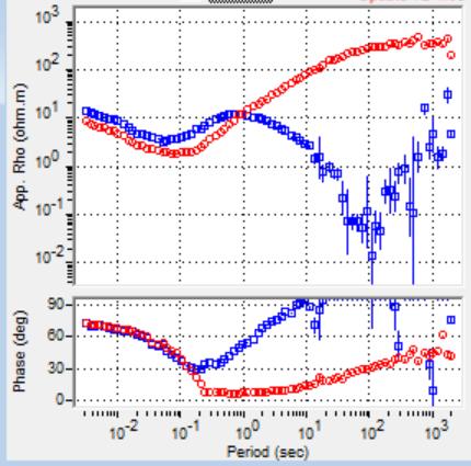
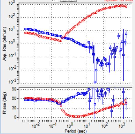
33 Phase Higher resistivity Standard MT Plot Ngozi-Songwe Geophysics Apparent Resistivity and Phase Spectra Basic MT display is apparent resistivity and phase versus frequency These must be inverted to rock resistivity versus depth (1D) or rock resistivity versus X-Y-Z (3D) At volcanic targets with a base of clay cap near 1000 m depth, xy and/or yx apparent resistivity is lowest near 1 Hz Phase and Apparent Resistivity are related and a mutual quality check Phase should usually vary like 1/slope of the apparent resistivity curve Mutual smooth constraints (like D+) are used to assess reliability Cumming (2013) 100 Hz 1 Hz.01 Hz Base of clay cap near 1 Hz Deeper Lower Frequency

34 More resistive Ngozi-Songwe Geophysics GOOD/BAD MT DATA Small Static Split Resistivity minimum near 1 Hz is response to resistivity increase below base of clay cap near 1000 m depth Electric Electric power power noise 0.05 noise to 2 Hz Deeper No resolution of base of clay cap due to noise Almost perfect MT data Base of the clay resolved MT demonstrates that a clay cap exists to >300 m depth Poor MT near 1 Hz implies base of the clay not resolved Cumming (2013)

35 Good/Bad MT From GIS/Google Earth Bad MT Site Good MT Site Cumming (2013)


36 Solving MT Equations With Remote Reference Gamble et al. (1979) Impedance tensor Local Remote Reference Impedance from cross-powers Dedicated Remote Reference Subscript r is remote reference Cumming (2013)
37 MT Time Series Processing Without and With Remote Reference Without remote reference Biased to low resistivity from 0.1 to 10 Hz due to magnetic noise With local remote reference Data very good, especially at 1 Hz Unsworth et al. (2007, Geophysics)

38 MT Static Distortion Alteration Cumming (2013) Ex, Ey 2 dipoles ~100 m Hx, Hy, Hz 3 magnetometers EM signal from sun and lightening Solar signal sometimes low 1 Hz is about 1 km deep Shallow features like surface alteration result in different resistivity on Ex and Ey dipole. This is called static distortion.


39 TDEM / TEM Cumming (2013) Pulse current in outer loop, measure signal in inner loop from smoke rings of current induced by magnetic field. TDEM depth often< 300 m, <<MT No electrodes so no static distortion Focused so less 2D/3D distortion Noisy data or no signal is sometimes misinterpreted

40 Quality assurance using voltage signal from detector Conductor causes voltage to decline more slowly. If no conductor, voltage declines to noise floor Data at later times is commonly incompletely edited, causing the noise after 10 msec to create a false low resistivity zone. Noise level separately recorded to help resolve this problem Cumming (2013) TEM Signal Recording of background noise Change in slope is response to low resistivity Change in slope is response to background noise

41 Non-Plane Wave Distortion Cumming (2013)


42 Non-Plane Wave (Near Field) Distortion Slope at 45 may be plane wave distortion CSAMT points with near field notch and 45 degree branch characteristic of near-field distortion MT with likely plane wave distortion at <0.1 Hz Cumming (2013)

 Cumming")
43 Ngozi BGR and GDC MT BGR (max 27) GDC (max 43) Cumming (2016) 43
44 Non-Plane Wave Distortion Slope >45 likely plane wave distortion from DC power line Apparent deep conductor Cumming (2013)

45 Non-Plane Wave Distortion Smoothed resistivity trend indicates increase below clay cap but no deep conductor Cumming (2013)
46 CSIMT (Coherent Source Interference MT) Guðni Rosenkjær, UBC (26-Feb- 2016) Research on use of the coherent power line noise as a signal Resistivity model with 4 ohm-m geothermal clay cap base at 700 m with magma at 9000 km Station 1500 m distance from power line Signal/Noise 0.1 Signal/Noise 0.5 Signal/Noise 1.0 Demonstrates serious distortion by power line at most signal/noise ratios
47 CSIMT Noise as Signal Guðni Rosenkjær, UBC (26-Feb- 2016) Research on use of the coherent power line noise as a signal Resistivity model with 4 ohm-m geothermal clay cap base at 700 m with magma at 9000 km Station 5000 m distance Demonstrates use of noise as signal for shallow cap at 5000 m distance with most signal/noise ratios Signal/Noise 0.1 Signal/Noise 0.5 Signal/Noise 1.0

48 Non-Plane Wave Distortion Songwe Cement Plant Cumming (2013)


49 Non-Plane Wave Distortion Mbeya Cumming (2013)

50 Ngozi-Songwe MT Survey MT conductance to 1000 m depth consistent with Songwe gravity MT conductor shows clay enclosing Ngozi Volcano, except to east Cumming (2016) 50
")
51 Ngozi MT Interpretation Cross-section 1 through Songwe to Ngozi Base of hydrothermal alteration locally 1000 m deep km (vertical exaggeration 4:1) Cumming (2016) 51
 Cumming (2016)")
52 Ngozi MT Interpretation Cross-section 1 through hot spring closest to Ngozi Base of hydrothermal alteration locally 1000 m deep Pattern consistent with distinct aquifers km (vertical exaggeration 1:1) Cumming (2016) 52
 km (vertical exaggeration 1:1) 53")
53 Songwe MT Interpretation Cross-section SO1 through hot spring with highest geothermometry Low-resistivity, clay-rich shallow volcanoclastics dip up from NE to SE consistent with half-graben Pattern consistent with upflow below low resistivity cap Cumming (2016) km (vertical exaggeration 1:1) 53
 Cumming (2016)")
54 Ngozi-Songwe Regional Gravity Data Usangu basin (Marobhe, 1989) for regional Awaiting regional data sets more relevant to Ngozi and Songwe (archiving issues) Cumming (2016) 54
")
55 Gravity at Ngozi is not diagnostic, except with regional trend At Songwe, gravity consistent with half graben dipping down to NE Integrate with regional and fit to Songwe MT cross-sections Ngozi-Songwe Geophysics Ngozi-Songwe Gravity Data Cumming (2016) 55
56 Depth to metamorphic basement in rift probably not feasible Need georectified gravity map with data points and preferably gravity principal facts Ngozi-Songwe Geophysics Ngozi-Songwe Gravity Data Cumming (2016) 56

57 Ngozi-Songwe Aeromagnetic Data Countrywide aeromagnetic survey from early 80 s Line spacing 1 km Flight height 120 m Of interest for structural implications Low relief northwest of Ngozi ambiguous since no shallow sulfate alteration Depth to metamorphic basement in rift probably not feasible Cumming (2016) 57
58 Ngozi-Songwe Geophysics Review Geophysical Program Low resistivity surrounding Ngozi Volcano consistent with apparently isolated chloride hydrology Some conduction or leakage to bicarbonate springs Gravity and MT consistent with Songwe half-graben MT consistent with upflow anywhere from graben center to vertical below springs Aeromagnetic data confirms structural continuity but interpretation in terms of sulfate alteration ambiguous Deep BGR TEM conductor disappears with revised editing Conceptual model review next week Cumming (2016)
59 Mar-2016 William Cumming Cumming Geoscience, Santa Rosa CA Office: Mobile: Skype: wcumming.com
Global occurrence of geothermal systems in different geologic settings: their identification and utilization
 Global occurrence of geothermal systems in different geologic settings: their identification and utilization Mar-2016 William Cumming Cumming Geoscience, Santa Rosa CA wcumming@wcumming.com Office: +1-707-546-1245
TECHNICAL REVIEW OF GEOTHERMAL POTENTIAL OF NGOZI AND SONGWE GEOTHERMAL PROSPECTS, TANZANIA.
 Proceedings, 6 th African Rift Geothermal Conference Addis Ababa, Ethiopia, 2 nd 4 th November 2016 TECHNICAL REVIEW OF GEOTHERMAL POTENTIAL OF NGOZI AND SONGWE GEOTHERMAL PROSPECTS, TANZANIA 1 Kenneth
MT Prospecting. Map Resistivity. Determine Formations. Determine Structure. Targeted Drilling
 MT Prospecting Map Resistivity Determine Formations Determine Structure Targeted Drilling Cross-sectional interpretation before and after an MT survey of a mineral exploration prospect containing volcanic
Exploration of Geothermal High Enthalpy Resources using Magnetotellurics an Example from Chile
 Exploration of Geothermal High Enthalpy Resources using Magnetotellurics an Example from Chile Ulrich Kalberkamp, Federal Institute for Geosciences and Natural Resources (BGR), Stilleweg 2, 30655 Hannover,
Application of Transient Electromagnetics for the Investigation of a Geothermal Site in Tanzania
 Application of Transient Electromagnetics for the Investigation of a Geothermal Site in Tanzania Gerlinde Schaumann, Federal Institute for Geosciences and Natural Resources (BGR), Stilleweg 2, 30655 Hannover,
Integrated Geophysical Model for Suswa Geothermal Prospect using Resistivity, Seismics and Gravity Survey Data in Kenya
 Proceedings World Geothermal Congress 2015 Melbourne, Australia, 19-25 April 2015 Integrated Geophysical Model for Suswa Geothermal Prospect using Resistivity, Seismics and Gravity Survey Data in Kenya
SUPPLEMENTARY INFORMATION
 SUPPLEMENTARY INFORMATION Supplementary online material for Bai et al., (2). EHS3D MT data collection Broadband magnetotelluric (MT) data were recorded on profiles P, P2 and P4 in the frequency band -.5
Gravity-Magnetic & Magneto-Telluric surveys in Purnea Onland Basin, India - A case history.
 P-281 Gravity-Magnetic & Magneto-Telluric surveys in Purnea Onland Basin, India - A case history. Summary A.K. Roy, D.P. Paine*, S. Sett, and H.N. Bhattacharya, ONGC This paper describes a case history
Geothermal Potential Assessment in Northern Rwanda
 Geothermal Potential Assessment in Northern Rwanda 2 nd African Rift Geothermal Conference Entebbe, Uganda Ngaruye, Jean-Claude 1) Jolie, Egbert 2) 1) Rwanda Geology and Mining Authority, OGMR 2) Federal
GEOTHERMAL RESOURCE CONCEPTUAL MODELS USING SURFACE EXPLORATION DATA
 PROCEEDINGS, Thirty-Fourth Workshop on Geothermal Reservoir Engineering Stanford University, Stanford, California, February 9-11, 2009 SGP-TR-187 GEOTHERMAL RESOURCE CONCEPTUAL MODELS USING SURFACE EXPLORATION
Geophysics for Geothermal Exploration
 Geophysics for Geothermal Exploration Dr. Hendra Grandis Geofisika - ITB Agenda Basic concept of Geophysics: : Review Geophysical signatures of a geothermal system Geophysical methods for geotermal exploration
. Slide 1. Geological Survey of Ethiopia, P.O.Box 2302, Addis Ababa, Ethiopia
 The electrical resistivity structure of the Southern Main Ethiopian Rift (around the Lake Abaya geothermal prospect) revealed by magneto-telluric telluric imaging Mohammednur Desissa and Yohanes Lema Geological
THREE DIMENSIONAL INVERSIONS OF MT RESISTIVITY DATA TO IMAGE GEOTHERMAL SYSTEMS: CASE STUDY, KOROSI GEOTHERMAL PROSPECT.
 Proceedings, 6 th African Rift Geothermal Conference Addis Ababa, Ethiopia, 2 nd 4 th November 2016 THREE DIMENSIONAL INVERSIONS OF MT RESISTIVITY DATA TO IMAGE GEOTHERMAL SYSTEMS: CASE STUDY, KOROSI GEOTHERMAL
Taller de Geotermica en Mexico Geothermal Energy Current Technologies
 Taller de Geotermica en Mexico Geothermal Energy Current Technologies presented by Paul Brophy, President/CEO EGS Inc. Mexico City October 10 th 2011 Presentation Topics General Geothermal Discussion Exploration
Topic 7: Geophysical and Remote Sensing Models. Presenter: Greg Ussher Organisation:SKM
 Topic 7: Geophysical and Remote Sensing Models Presenter: Greg Ussher Organisation:SKM Email: gussher@globalskm.com Overview Surface-based imaging of subsurface characteristics That indicate geothermal
The Role of Magnetotellurics in Geothermal Exploration
 The Role of Magnetotellurics in Geothermal Exploration Adele Manzella CNR - Via Moruzzi 1 56124 PISA, Italy manzella@igg.cnr.it Foreword MT is one of the most used geophysical methods for geothermal exploration.
Seismic Reflection Data and Conceptual Models for Geothermal Development in Nevada
 Proceedings World Geothermal Congress 2010 Bali, Indonesia, 25-29 April 2010 Seismic Reflection Data and Conceptual Models for Geothermal Development in Nevada Glenn Melosh 1, William Cumming 2, John Casteel
Three-dimensional geophysical modelling of the Alalobeda geothermal field
 Three-dimensional geophysical modelling of the Alalobeda geothermal field Daniele Rizzello 1, Egidio Armadillo 2, Claudio Pasqua 2,3, Massimo Verdoya 2, Solomon Kebede 4, Andarge Mengiste 4, Getenesh H/Giorgis
INTERGRATED GEOPHYSICAL METHODS USED TO SITE HIGH PRODUCER GEOTHERMAL WELLS
 Presented at Short Course VII on Exploration for Geothermal Resources, organized by UNU-GTP, GDC and KenGen, at Lake Bogoria and Lake Naivasha, Kenya, Oct. 27 Nov. 18, 2012. GEOTHERMAL TRAINING PROGRAMME
Geophysical Surveys of The Geothermal System of The Lakes District Rift, Ethiopia
 Geophysical Surveys of The Geothermal System of The Lakes District Rift, Ethiopia By: Befekadu Oluma By: Geophysics Department Geological Survey of Ethiopia The formation of the rift was preceded by a
GEOTHERMAL ENERGY DEVELOPMENT IN UGANDA - A COUNTRY UPDATE 2016
 GEOTHERMAL ENERGY DEVELOPMENT IN UGANDA - A COUNTRY UPDATE 2016 Godfrey Bahati Ministry of Energy and Mineral Development, P.O Box 7072, Kampala, Uganda. Presented at the Sixth African Rift Geothermal
Three Dimensional Inversions of MT Resistivity Data to Image Geothermal Systems: Case Study, Korosi Geothermal Prospect
 PROCEEDINGS, 42nd Workshop on Geothermal Reservoir Engineering Stanford University, Stanford, California, February 13-15, 2017 SGP-TR-212 Three Dimensional Inversions of MT Resistivity Data to Image Geothermal
Data Repository Comeau et al., (2015)
") Data Repository 2015087 Comeau et al., (2015) 1. Magnetotelluric data Owing to the remote location, and large distance from sources of electromagnetic noise, most stations were characterized by high quality
Data Repository 2015087 Comeau et al., (2015) 1. Magnetotelluric data Owing to the remote location, and large distance from sources of electromagnetic noise, most stations were characterized by high quality
PUBLISHED VERSION.
 PUBLISHED VERSION S. Thiel, J.R. Peacock, J. MacFarlane and G. Heinson Electromagnetic monitoring of fluid injection - lessons learned Proceedings of the 2012 Australian Geothermal Energy Conference, 2012
Overview of geophysical methods used in geophysical exploration
 Overview of geophysical methods used in geophysical exploration Lúdvík S. Georgsson United Nations University Geothermal Training Programme Orkustofnun Reykjavík ICELAND The role of the geophysicist Measuring
Magnetotelluric Survey in an Extremely Noisy Environment at the Pohang Low-Enthalpy Geothermal Area, Korea
 Proceedings World Geothermal Congress 2005 Antalya, Turkey, 24-29 April 2005 Magnetotelluric Survey in an Extremely Noisy Environment at the Pohang Low-Enthalpy Geothermal Area, Korea Toshihiro Uchida
Resistivity structure of Sumikawa geothermal field, northeastern Japan, obtained from magnetotelluric data. Toshihiro Uchida
 Resistivity structure of Sumikawa geothermal field, northeastern Japan, obtained from magnetotelluric data Toshihiro Geological Survey of Japan 1-1-3 Higashi, Tsukuba, Ibaraki 35, Japan ABSTRACT: Resistivity
STRUCTURAL CONTROL OF RUNGWE VOLCANIC PROVINCE AND ITS IMPLICATION ON GEOTHERMAL SYSTEM
 Proceedings, 6 th African Rift Geothermal Conference Addis Ababa, Ethiopia, 2 nd 4 th November 2016 STRUCTURAL CONTROL OF RUNGWE VOLCANIC PROVINCE AND ITS IMPLICATION ON GEOTHERMAL SYSTEM Albano Mahecha¹,
Marine Science and Oceanography
 Marine Science and Oceanography Marine geology- study of the ocean floor Physical oceanography- study of waves, currents, and tides Marine biology study of nature and distribution of marine organisms Chemical
Comparison of 1-D, 2-D and 3-D Inversion Approaches of Interpreting Electromagnetic Data of Silali Geothermal Area
 Proceedings World Geothermal Congress 2015 Melbourne, Australia, 19-25 April 2015 Comparison of 1-D, 2-D and 3-D Inversion Approaches of Interpreting Electromagnetic Data of Silali Geothermal Area Charles
Geophysical exploration methods at European sites
 Geophysical exploration methods at European sites David Bruhn, GFZ Potsdam, Section 5.2 Geothermics, 14473 Potsdam, Germany Most geophysical exploration methods have been developed for the oil and gas
Euler Deconvolution JAGST Vol. 15(1) 2013
 2013") Euler Deconvolution JAGST Vol. 15(1) 2013 2D-EULER DECONVOLUTION AND FORWARD MODELING OF GRAVITY DATA OF HOMA-HILLS GEOTHERMAL PROSPECT, KENYA A. Odek 1, A. B. Otieno 1, W. J. Ambusso 1 and J. G. Githiri
Euler Deconvolution JAGST Vol. 15(1) 2013 2D-EULER DECONVOLUTION AND FORWARD MODELING OF GRAVITY DATA OF HOMA-HILLS GEOTHERMAL PROSPECT, KENYA A. Odek 1, A. B. Otieno 1, W. J. Ambusso 1 and J. G. Githiri
RESISTIVITY IMAGING IN EASTERN NEVADA USING THE AUDIOMAGNETOTELLURIC METHOD FOR HYDROGEOLOGIC FRAMEWORK STUDIES. Abstract.
 RESISTIVITY IMAGING IN EASTERN NEVADA USING THE AUDIOMAGNETOTELLURIC METHOD FOR HYDROGEOLOGIC FRAMEWORK STUDIES Darcy K. McPhee, U.S. Geological Survey, Menlo Park, CA Louise Pellerin, Green Engineering,
APPENDIX C GEOLOGICAL CHANCE OF SUCCESS RYDER SCOTT COMPANY PETROLEUM CONSULTANTS
 APPENDIX C GEOLOGICAL CHANCE OF SUCCESS Page 2 The Geological Chance of Success is intended to evaluate the probability that a functioning petroleum system is in place for each prospective reservoir. The
Effective geochemical methods for identifying geothermal systems in the western branch of the EARS
 Technical Workshop on the Geologic Development and Geophysics of the Western Branch of the Greater East African Rift System with Emphasis on Factors that Control the Development of their Geothermal Systems
PART A: Short-answer questions (50%; each worth 2%)
") PART A: Short-answer questions (50%; each worth 2%) Your answers should be brief (just a few words) and may be written on these pages if you wish. Remember to hand these pages in with your other exam pages!
PART A: Short-answer questions (50%; each worth 2%) Your answers should be brief (just a few words) and may be written on these pages if you wish. Remember to hand these pages in with your other exam pages!
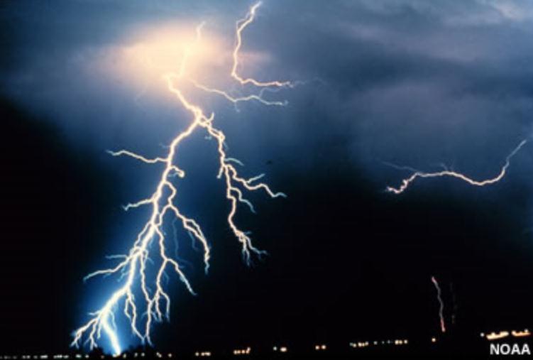
Mapping Faults With Lightning, Natural-Sourced Electromagnetics (NSEM) Louis J. Berent Dynamic Measurement, LLC
 Louis J. Berent Dynamic Measurement, LLC") Mapping Faults With Lightning, Natural-Sourced Electromagnetics (NM) Louis J. Berent Dynamic Measurement, LLC 23 June 2015 Validating NM with 2-D Resistivity Imaging Profiling & Ground Penetrating Radar
Mapping Faults With Lightning, Natural-Sourced Electromagnetics (NM) Louis J. Berent Dynamic Measurement, LLC 23 June 2015 Validating NM with 2-D Resistivity Imaging Profiling & Ground Penetrating Radar
Welcome to GEO 101 Introduction to Geology
 Welcome to GEO 101 Introduction to Geology so what is Geology? not just rocks! Geology is... study of Earth and planetary bodies processes responsible for formation processes that modify all areas of geology
The Cerattepe Massive Sulphide Property, Northeastern Turkey
 Integrated Exploration Case Histories Paper 139 Explor97 Master Page Explor97 Contents Previous Paper G O T O Author Index Section Contents The Cerattepe Massive Sulphide Property, Northeastern Turkey
Introducing the Stratagem EH4. Electrical Conductivity Imaging System Hybrid-Source Magnetotellurics
 Introducing the Stratagem EH4 Electrical Conductivity Imaging System Hybrid-Source Magnetotellurics Stratagem EH4 Hybrid-Source Magnetotellurics Frequency range of 10 Hz to 90k Hz Approx. depth of investigation
The Gulf of Mexico - From Various Vantage Points John E. Bain, Kenton J. Hamilton
 The Gulf of Mexico - From Various Vantage Points John E. Bain, Kenton J. Hamilton Oftentimes in exploration geophysics we tend to focus on specific near-term exploration prospects, as dictated by the current
Continental Margin Geology of Korea : Review and constraints on the opening of the East Sea (Japan Sea)
") Continental Margin Geology of Korea : Review and constraints on the opening of the East Sea (Japan Sea) Han-Joon Kim Marine Satellite & Observation Tech. Korea Ocean Research and Development Institute
Continental Margin Geology of Korea : Review and constraints on the opening of the East Sea (Japan Sea) Han-Joon Kim Marine Satellite & Observation Tech. Korea Ocean Research and Development Institute
A) B) C) D) 4. Which diagram below best represents the pattern of magnetic orientation in the seafloor on the west (left) side of the ocean ridge?
 B) C) D) 4. Which diagram below best represents the pattern of magnetic orientation in the seafloor on the west (left) side of the ocean ridge?") 1. Crustal formation, which may cause the widening of an ocean, is most likely occurring at the boundary between the A) African Plate and the Eurasian Plate B) Pacific Plate and the Philippine Plate C)
1. Crustal formation, which may cause the widening of an ocean, is most likely occurring at the boundary between the A) African Plate and the Eurasian Plate B) Pacific Plate and the Philippine Plate C)
SPECTRAL ANALYSIS OF GROUND MAGNETIC DATA IN MAGADI AREA, SOUTHERN KENYA RIFT
 SPECTRAL ANALYSIS OF GROUND MAGNETIC DATA IN MAGADI AREA, SOUTHERN KENYA RIFT 1 JG Githiri, 2 JP Patel, 3 JO Barongo and 4 PK Karanja 1 Jomo-Kenyatta University of Agriculture, Science and Technology,
Interpretation of Subsurface Geological Structure of Massepe Geothermal Area Using Resistivity Data
 Proceedings World Geothermal Congress 2010 Bali, Indonesia, 25-29 April 2010 Interpretation of Subsurface Geological Structure of Massepe Geothermal Area Using Resistivity Data Ahmad Zarkasyi and Yuanno
Chapter 02 The Sea Floor
 Chapter 02 The Sea Floor Multiple Choice Questions 1. One of the following is not one of the world's major ocean basins: A. Atlantic Ocean B. Arctic Ocean C. Indian Ocean D. Antarctic Ocean E. Pacific
BULLS-EYE! - SIMPLE RESISTIVITY IMAGING TO RELIABLY LOCATE THE GEOTHERMAL RESERVOIR
 BULLS-EYE! - SIMPLE RESISTIVITY IMAGING TO RELIABLY LOCATE THE GEOTHERMAL RESERVOIR Errol Anderson, Daryl Crosby and Greg Ussher PB Power GENZL Division, P O Box 3935, Auckland, New Zealand Key Words:
Characterizing a geothermal reservoir using broadband 2-D MT survey in Theistareykir, Iceland
 KMS Technologies KJT Enterprises Inc. An EMGS/RXT company Characterizing a geothermal reservoir using broadband 2-D MT survey in Theistareykir, Iceland Yu, G., Strack, K. M., Allegar, N., Gunnarsson, Á.
1D and 2D Inversion of the Magnetotelluric Data for Brine Bearing Structures Investigation
 1D and 2D Inversion of the Magnetotelluric Data for Brine Bearing Structures Investigation Behrooz Oskooi *, Isa Mansoori Kermanshahi * * Institute of Geophysics, University of Tehran, Tehran, Iran. boskooi@ut.ac.ir,
Geo-scientific Data Integration to Evaluate Geothermal Potential Using GIS (A Case for Korosi-Chepchuk Geothermal Prospects, Kenya)
") Geo-scientific Data Integration to Evaluate Geothermal Potential Using GIS (A Case for Korosi-Chepchuk Geothermal Prospects, Kenya) Levi Shako and Joseph Mutua Geothermal Development Company, P. O. Box
Geo-scientific Data Integration to Evaluate Geothermal Potential Using GIS (A Case for Korosi-Chepchuk Geothermal Prospects, Kenya) Levi Shako and Joseph Mutua Geothermal Development Company, P. O. Box
HYDROCARBON EXPLORATION IN THE ALBERTINE GRABEN OF THE EAST AFRICAN RIFT SYSTEM
 IN THE ALBERTINE GRABEN OF THE EAST AFRICAN RIFT SYSTEM GEOPRISM; EAST AFRICAN RIFT SYSTEM PLANNING WORKSHOP By: Dozith Abeinomugisha Ministry of Energy and Mineral Development, Entebbe, Uganda 1 BACKGROUND
Exploring for geothermal reservoirs using broadband 2-D MT and gravity in Hungary
 KMS Technologies KJT Enterprises Inc. An EMGS/RXT company Exploring for geothermal reservoirs using broadband 2-D MT and gravity in Hungary Tulinius, H., Adám, L., Halldórsdóttir, H.,Yu, G., Strack, K.
Structure of the Earth
 Structure of the Earth Compositional (Chemical) Layers Crust: Low density Moho: Density boundary between crust and mantle Mantle: Higher density High in Magnesium (Mg) and Iron (Fe) Core: High in Nickel
GEOTHERMAL ENERGY POTENTIAL FOR LONGONOT PROSPECT, KENYA. By Mariita N. O. Kenya Electricity Generating Company
 GEOTHERMAL ENERGY POTENTIAL FOR LONGONOT PROSPECT, KENYA By Mariita N. O. Kenya Electricity Generating Company PRESENTATION OUTLINE INTRODUCTION REGIONAL SETTING GEOLOGY GEOTHERMAL MANIFESTATIONS HYDROGEOLOGY
GEOTHERMAL ENERGY EXPLORATION IN UGANDA, COUNTRY UPDATE 2006
 GEOTHERMAL ENERGY EXPLORATION IN UGANDA, COUNTRY UPDATE 2006 Godfrey Bahati Department of Geological Survey and Mines, P.O Box 9, Entebbe, Uganda First East African Rift Geothermal Conference-ARGeo ARGeo-C1
3D MAGNETOTELLURIC CHARACTERIZATION OF THE COSO GEOTHERMAL FIELD
 PROCEEDINGS, Thirtieth Workshop on Geothermal Reservoir Engineering Stanford University, Stanford, California, January 31-February 2, 2005 SGP-TR-176 3D MAGNETOTELLURIC CHARACTERIZATION OF THE COSO GEOTHERMAL
Marine EM on Land: MT Measurements in Mono Lake. Steven Constable, UCSD/SIO Jared Peacock, USGS EMIW 2018
 Marine EM on Land: MT Measurements in Mono Lake Steven Constable, UCSD/SIO Jared Peacock, USGS EMIW 218 Mono Lake sits in the Mono Basin, where the Basin and Range meets the Sierra Nevada. The Sierra Nevada
Geology 300, Physical Geology Spring 2019 Quiz Ch 19, Plate Tectonics Name
 Geology 300, Physical Geology Spring 2019 Quiz Ch 19, Plate Tectonics Name MULTIPLE CHOICE. Choose the one alternative that best completes the statement or answers the question. 1) The portion of a fracture
Keywords: geophysics field camp, low to moderate, temperature, geothermal system, Mt Pancar, Indonesia
 Proceedings World Geothermal Congress 2015 Melbourne, Australia, 19-25 April 2015 Geophysics Field Camp (GFC): A Student Project Aimed to Investigate the Low to Moderate Temperature Geothermal System in
Late 20 th Century Tests of the Continental Drift Hypothesis
 Late 20 th Century Tests of the Continental Drift Hypothesis 5 Characteristics of the Ocean Trenches Unless otherwise noted the artwork and photographs in this slide show are original and by Burt Carter.
APPENDIX A: Magnetotelluric Data in Relation to San Pedro Mesa Structural. The San Pedro Mesa structural high (discussed in main text of paper) was
 was") Page of DR for GSA Special Paper 9, Chapter, Geophysical constraints APPENDIX A: Magnetotelluric Data in Relation to San Pedro Mesa Structural High The San Pedro Mesa structural high (discussed in main
Page of DR for GSA Special Paper 9, Chapter, Geophysical constraints APPENDIX A: Magnetotelluric Data in Relation to San Pedro Mesa Structural High The San Pedro Mesa structural high (discussed in main
POTASH DRAGON CHILE GEOPHYSICAL SURVEY TRANSIENT ELECTROMAGNETIC (TEM) METHOD. LLAMARA and SOLIDA PROJECTS SALAR DE LLAMARA, IQUIQUE, REGION I, CHILE
 METHOD. LLAMARA and SOLIDA PROJECTS SALAR DE LLAMARA, IQUIQUE, REGION I, CHILE") POTASH DRAGON CHILE GEOPHYSICAL SURVEY TRANSIENT ELECTROMAGNETIC (TEM) METHOD LLAMARA and SOLIDA PROJECTS SALAR DE LLAMARA, IQUIQUE, REGION I, CHILE OCTOBER 2012 CONTENT Page I INTRODUCTION 1 II FIELD
POTASH DRAGON CHILE GEOPHYSICAL SURVEY TRANSIENT ELECTROMAGNETIC (TEM) METHOD LLAMARA and SOLIDA PROJECTS SALAR DE LLAMARA, IQUIQUE, REGION I, CHILE OCTOBER 2012 CONTENT Page I INTRODUCTION 1 II FIELD
GEOCHEMISTRY OF RWENZORI HOT SPRINGS. Vincent Kato Department of Geological Survey and Mines, Entebbe, Uganda
 GEOCHEMISTRY OF RWENZORI HOT SPRINGS Vincent Kato Department of Geological Survey and Mines, Entebbe, Uganda RWENZORI Length of 115Km Width of central dome 48 64 km Highest peak >5105m SnowyMountain Lakes
Integrated interpretation of multimodal geophysical data for exploration of geothermal resources Case study: Yamagawa geothermal field in Japan
 Integrated interpretation of multimodal geophysical data for exploration of geothermal resources Case study: Yamagawa geothermal field in Japan Masashi Endo*(TechnoImaging), Alex Gribenko (TechnoImaging
Continental Landscapes
 Continental Landscapes Landscape influenced by tectonics, climate & differential weathering Most landforms developed within the last 2 million years System moves toward an equilibrium Continental Landscapes
Integrated Fracture Identification with Z-VSP and Borehole Images: A study from Cambay Basin
 P-124 Integrated Fracture Identification with Z-VSP and Borehole Images: A study from Cambay Basin Sattwati Dey, Jubilant Energy; Chandramani Shrivastva, Schlumberger; Sreemanti Gijare*, Schlumberger;
Assessing our untapped energy resources. Derek Reay Geological Survey of Northern Ireland
 Assessing our untapped energy resources Derek Reay Geological Survey of Northern Ireland Talk Outline Northern Ireland energy market Oil and Gas Exploration Description Exploration risks Application of
Earthquakes. Earthquakes are caused by a sudden release of energy
 Earthquakes Earthquakes are caused by a sudden release of energy The amount of energy released determines the magnitude of the earthquake Seismic waves carry the energy away from its origin Fig. 18.1 Origin
Earth. Temp. increases with depth, the thermal gradient is 25 o C/km. Pressure and density also increase with depth.
 Plate Tectonics Earth Earth overall average density = 5.5 g/cm 3. Temp. increases with depth, the thermal gradient is 25 o C/km. Pressure and density also increase with depth. Spheroid: with a longer major
Airborne Geophysics to Map Groundwater. Bill Brown
 Airborne Geophysics to Map Groundwater Bill Brown bb@skytem.com A 6 borehole represents 1 millionth of an acre Aquifer Materials An aquifer is an underground layer of water bearing permeable rock, rock
Characterization of Induced Seismicity in a Petroleum Reservoir: A Case Study
 Characterization of Induced Seismicity in a Petroleum Reservoir: A Case Study Edmond Sze, M. Nafi Toksöz, and Daniel R. Burns Earth Resources Laboratory Dept. of Earth, Atmospheric and Planetary Sciences
Status of geothermal energy exploration at Buranga geothermal prospect, Western Uganda
 Status of geothermal energy exploration at Buranga geothermal prospect, Western Uganda ARGeo-C6, Addis Ababa 2016 James Francis Natukunda and Godfrey Bahati Ministry of Energy and Mineral Development Directorate
Magnetotelluric (MT) Method
 Method") Magnetotelluric (MT) Method Dr. Hendra Grandis Graduate Program in Applied Geophysics Faculty of Mining and Petroleum Engineering ITB Geophysical Methods Techniques applying physical laws (or theory) to
Magnetotelluric (MT) Method Dr. Hendra Grandis Graduate Program in Applied Geophysics Faculty of Mining and Petroleum Engineering ITB Geophysical Methods Techniques applying physical laws (or theory) to
Lawrence Berkeley Laboratory, MS 74R316C, One Cyclotron Road, Berkeley CA 94720, USA.
 Proceedings World Geothermal Congress 2015 Melbourne, Australia, 19-25 April 2015 The Importance of Full Impedance Tensor Analysis for 3D Magnetotelluric Imaging the Roots of High Temperature Geothermal
Topic 5: The Dynamic Crust (workbook p ) Evidence that Earth s crust has shifted and changed in both the past and the present is shown by:
 Evidence that Earth s crust has shifted and changed in both the past and the present is shown by:") Topic 5: The Dynamic Crust (workbook p. 65-85) Evidence that Earth s crust has shifted and changed in both the past and the present is shown by: --sedimentary horizontal rock layers (strata) are found
Topic 5: The Dynamic Crust (workbook p. 65-85) Evidence that Earth s crust has shifted and changed in both the past and the present is shown by: --sedimentary horizontal rock layers (strata) are found
The Afar Rift Consortium
 The Afar Rift Consortium University of Bristol University of Oxford University of Cambridge British Geological Survey University of Rochester University of Auckland, NZ Opportunistic programme following
COPPER REEF Mining Corporation. July 18, 2018
 COPPER REEF Mining Corporation Analyses of Airborne South and West of Alberts Lake Anomalies July 18, 2018 R.W. Groom, PhD,BMath Petros Eikon Incorporated Orangeville, ON Stephen Masson, M.Sc., P.Geo.
GREATLAND GOLD PLC (AIM:GGP) ERNEST GILES PROJECT - EASTERN YILGARN
 ERNEST GILES PROJECT - EASTERN YILGARN") GREATLAND GOLD PLC (AIM:GGP) ERNEST GILES PROJECT - EASTERN YILGARN Ownership Greatland Pty Ltd 100% Area 1,800 square kilometres Licences E38/2204 Calanchini Granted E38/2882 Carnegie Granted E38/3183
GREATLAND GOLD PLC (AIM:GGP) ERNEST GILES PROJECT - EASTERN YILGARN Ownership Greatland Pty Ltd 100% Area 1,800 square kilometres Licences E38/2204 Calanchini Granted E38/2882 Carnegie Granted E38/3183
Conceptual model for non-volcanic geothermal resources - examples from Tohoku Japan
 Conceptual model for non-volcanic geothermal resources - examples from Tohoku Japan S. Tamanyu 1 and K. Sakaguchi 2 1, 2 Geological Survey of Japan, National Institute of Advanced Industrial Science and
Magnetic and Gravity Methods for Geothermal Exploration
 Magnetic and Gravity Methods for Geothermal Exploration Dr. Hendra Grandis Geophysics - ITB method and survey procedure Aero- or ground magnetic (covers a large area) Schlumberger resistivity mapping and
KS3 Chemistry. 8H The Rock Cycle. 8H The Rock Cycle. Sedimentary rocks. Metamorphic rocks. Igneous rocks. The rock cycle. Summary activities
 KS3 Chemistry 1of 20 38 12of 20 38 Examples of sedimentary rocks How can you describe sandstone? limestone chalk Sandstone is sandstone sandstone an orangey-coloured rock which looks like lots of sand
THREE DIMENSIONAL MODELING OF GEOELECTRICAL STRUCTURE BASED ON MT AND TDEM DATA IN MORI GEOTHERMAL FIELD, HOKKAIDO, JAPAN
 THREE DIMENSIONAL MODELING OF GEOELECTRICAL STRUCTURE BASED ON MT AND TDEM DATA IN MORI GEOTHERMAL FIELD, HOKKAIDO, JAPAN Tatsuya Kajiwara 1, Tohru Mogi 2, Elena Fomenko 3 and Sachio Ehara 4 1 JMC Geothermal
STATUS OF GEOTHERMAL ENERGY PROJECTS IN TANZANIA
 STATUS OF GEOTHERMAL ENERGY PROJECTS IN TANZANIA Regional Geothermal Stakeholders Workshop for East African Rift System Countries and Partners 15-17 March 2010 Nairobi - Kenya Gabriel Mbogoni (Geologist-GST)
GO ON. Directions: Use the diagram below to answer question 1.
 d i a g n o s t i c t e s t : e a r t h a n d s p a c e s c i e n c e question 1. 1. What is the correct order (starting from the surface) of Earth s layers? A crust, outer core, inner core, mantle B mantle,
MUHAMMAD S TAMANNAI, DOUGLAS WINSTONE, IAN DEIGHTON & PETER CONN, TGS Nopec Geological Products and Services, London, United Kingdom
 Geological and Geophysical Evaluation of Offshore Morondava Frontier Basin based on Satellite Gravity, Well and regional 2D Seismic Data Interpretation MUHAMMAD S TAMANNAI, DOUGLAS WINSTONE, IAN DEIGHTON
CONTENT. A. Changes in the Crust Facts Changes Construction and Destruction. B. Continental Drift What is it? Evidence
 Name Earth Science Date Period TOPIC THE DYNAMIC EARTH CONTENT A. Changes in the Crust Facts Changes Construction and Destruction B. Continental Drift What is it? Evidence C. Theory of Plate Tectonics
Figure 1 Extensional and Transform Fault Interaction, Influence on the Upper Cretaceous Hydrocarbon System, Equatorial Margin, West Africa.
 Figure 1 Extensional and Transform Fault Interaction, Influence on the Upper Cretaceous Hydrocarbon System, Equatorial Margin, West Africa. Presented to the 10th PESGB/HGS Conference on Africa E + P September
High Resolution Geophysics: A Better View of the Subsurface. By John Jansen, P.G., Ph.D., Aquifer Science and Technology
 High Resolution Geophysics: A Better View of the Subsurface By John Jansen, P.G., Ph.D., Aquifer Science and Technology Geologist Use Only Part of the Information Available To Them Most Geologist rely
Plates & Boundaries The earth's continents are constantly moving due to the motions of the tectonic plates.
 Plates & Boundaries The earth's continents are constantly moving due to the motions of the tectonic plates. As you can see, some of the plates contain continents and others are mostly under the ocean.
The Resistivity Structure of the Abaya Geothermal field,
 Geological Survey of Ethiopia Hydrogeology, Engineering geology and Geothermal Department The Resistivity Structure of the Abaya Geothermal field, Southern Main Ethiopian Rift, Revealed by Magneto-telluric
SANDER GEOPHYSICS LW 42D13SW ISLE ST. IGNACE RICHMONl
 SANDER GEOPHYSICS LW 42D13SW8363 83.1-117 ISLE ST. IGNACE 010 1305 RICHMONl REPORT ON THE HELICOPTER BORNE EM AND MAGNETOMETER SURVEY OFF ST. IGNACE ISLAND, LAKE SUPERIOR THUNDERBAY MINING DISTRICT, ONTARIO
GEOTHERMAL POTENTIAL OF ST. KITTS AND NEVIS ISLANDS
 GEOTHERMAL POTENTIAL OF ST. KITTS AND NEVIS ISLANDS By Gerald W. Huttrer Geothermal Management Company, Inc. For the Eastern Caribbean Geothermal Energy Project ( Geo- Caraibes ; G-C ) Presented Using
Composition of the earth, Geologic Time, and Plate Tectonics
 Composition of the earth, Geologic Time, and Plate Tectonics Layers of the earth Chemical vs. Mechanical Chemical : Mechanical: 1) Core: Ni and Fe 2) Mantle: Mostly Peridotite 3) Crust: Many different
C5 Magnetic exploration methods data analysis techniques
 C5 Magnetic exploration methods data analysis techniques C5.1 Data processing and corrections After magnetic field data have been collected a number of corrections are applied to simplify the interpretation.
INFRARED AND SATELLITE IMAGES, AERIAL PHOTOGRAPHY
 Presented at Short Course VI on Exploration for Geothermal Resources, organized by UNU-GTP, GDC and KenGen, at Lake Bogoria and Lake Naivasha, Kenya, Oct. 27 Nov. 18, 2011. GEOTHERMAL TRAINING PROGRAMME
Heat (& Mass) Transfer. conceptual models of heat transfer. large scale controls on fluid movement. distribution of vapor-saturated conditions
 Transfer. conceptual models of heat transfer. large scale controls on fluid movement. distribution of vapor-saturated conditions") Heat (& Mass) Transfer conceptual models of heat transfer temperature-pressure gradients large scale controls on fluid movement distribution of vapor-saturated conditions fluid flow paths surface manifestations
Heat (& Mass) Transfer conceptual models of heat transfer temperature-pressure gradients large scale controls on fluid movement distribution of vapor-saturated conditions fluid flow paths surface manifestations
Exploration results and resource conceptual model of the Tolhuaca Geothermal Field, Chile
 Proceedings World Geothermal Congress 2010 Bali, Indonesia, 25-29 April 2010 Exploration results and resource conceptual model of the Tolhuaca Geothermal Field, Chile Glenn Melosh 1, William Cumming 2,
3D MAGNETOTELLURIC SURVEY AT THE YANAIZU-NISHIYAMA GEOTHERMAL FIELD, NORTHERN JAPAN
 3D MAGNETOTELLURIC SURVEY AT THE YANAIZU-NISHIYAMA GEOTHERMAL FIELD, NORTHERN JAPAN Toshihiro Uchida 1, Shinichi Takakura 1, Takumi Ueda 1, Masaho Adachi 2, Hitoshi Ozeki 2, Kunikazu Kamada 3, Tatsuya
WAMUNYU EDWARD MUREITHI I13/2358/2007
 WAMUNYU EDWARD MUREITHI I13/2358/2007 Olkaria geothermal area is situated south of Lake Naivasha on the floor of the southern segment of the Kenya rift. The geology of the Olkaria Geothermal area is subdivided
Horizontal gradient and band-pass filter of aeromagnetic data image the subsurface structure; Example from Esh El Mellaha Area, Gulf of Suez, Egypt.
 Horizontal gradient and band-pass filter of aeromagnetic data image the subsurface structure; Example from Esh El Mellaha Area, Gulf of Suez, Egypt. Essam Aboud 1, Serguei Goussev 2, Hassan Hassan 2, Suparno