EL CAPITAN,MINERAL CLAIMS (Group mineral claims - BART, BART 1, TESS, TESS 1, TROY)
|
|
|
- Jerome O’Neal’
- 5 years ago
- Views:
Transcription
1 EL CAPITAN,MINERAL CLAIMS (Group mineral claims - BART, BART 1, TESS, TESS 1, TROY) Mining Division: Victoria, B.C. Lat: Long NTS 092C 16E Owners: D. Brouwer D. Herriott PROSPECTING REPORT Submitted on January 4th, 2005 By D. Brouwer and D. Herriott Resubmitted November 15,2005
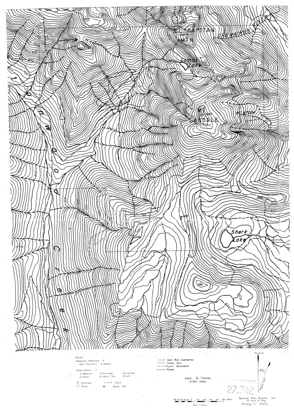
2 Table of Contents Introduction. Property Description. Location. and Access and History...p age 2 Map 1. General property location... page 3 Map 2. Claim location and topography... Page 4 History... page 5 Economic Setting... page 6... Map 3. Areas of interest for work proposed in 2005 Page 7 Prospecting... Page 9 Trail Construction. Proposed Field Work for page 10 Statements of Qualifications.....page 1 1 Statement of Assessment Work......p age 12 Appendix I 2004 El Capitan Study Area (fold out map)...p age 13...
3 1. Introduction Doug Heniott of 5968 Parkway Drive, Nanaimo B.C. and Doug Brouwer of 1686 Brierley Hill, Nanaimo, B.C. hold sole title of the El Capitan group of mineral claims located on Vancouver Island, near Cowichan Lake and north of the village of Youbou. 2. Property Description The El Capitan Claim consists of 5 mineral claims totalling 41 units as summarized below. Claim Name Tenure No. Anniversary Date Bart - 8 units, 2Nx4E January 17,2005 Bart 1-12 units, 3s x 4E January 17,2005 Tess - 6 units, 2N x 3 W January 17,2005 Tess 1-9 units, 3s x 3W January 17,2005 Troy - 6 units, 2s x 3E June 14,2005 T The common legal corner posts for the Bart, Bart 1, Tess and Tess 1 is situated at about 760 metres at latitude 48' 13' 49" W and longitude 48' 56' 52". From the legal corner post the claims extend as indicated above. 3. Location and Access The El Capitan claims are located on Vancouver Island in the Victoria Mining District (see map 1). The claims are about 7 kilometres north of Youbou on Cowichan Lake and 30 kilometres southwest of Nanaimo. The claims straddle the valley between Cottonwood Creek and Chemainus River and include Mount Landale, and El Capitan Mountain (see map 2). Access is by highway 18 along the north side of Cowichan Lake approximately 16 kilometres west fiom the village of Lake Cowichan to the mouth of Cottonwood Creek. Proceed north on a logging road for approximately 7 kilometres along Cottonwood Creek mainline. Turn east on a deactivated logging road that follows East Cottonwood Creek. After approximately 2 kilometres the road becomes impassable to vehicles due to deactivation. The LCP for the first four claims in the group is located about 1 kilometre fiom the terminus of the road on foot. The LCP for the Troy which makes up the last of the five claims is located on the southern boundary of the Tess I claim (see map 3). Access to the Troy claim is obtained by using the Widow Creek logging road located along the east side of Cottonwood creek. About 5 kilometres along this road, the LCP can be found about 50 meters below the north side of the road.
4 GENERAL PROPERTY LOCATION MAP


5 CLAIM LOCATIONS AND TOPGRAPHIC MAP
6 4. History The present El Capitan property, is composed of the El Captain, Cottonwood and Paint Pot showings and includes the old workings of these prospects. It encompasses both the Spaniard and Capitan claims which were under option to Omega Gold Corporation in The majority of past work has been done in the area of the El Captain prospect. Surface stripping and a 2 metre drift driven on a heavily oxidized 0.5 metre vein (Cottonwood showing) within an east west shear zone was done prior to In 1927, a 15mtre drift (no. 2 adit), was driven westward along a shear striking 100/80S. Samples collected in the drift returning values at the time of sampling of $15.00 /ton mainly in gold. Sulphide ribs were samples and assays were reported of $39.00/ton gold are reported. The drift extends for approximately 30 metres as is still reported to be in the oxidized zone. In 1935 the El Capitan was optioned by Lomass and Powell. Lomass and Powell drove a 65 metre adit on the west side of the summit of El Capitan(?). A well defined fault was encountered 7 metres south fiom the face continuing for 23 metres, Local rusty gouge in minor quartzites within a 20 cm grey gouge zone returned only traces of gold and silver. A 35 cm wide fissure was discovered below the adit. The fissure is reported to have contained abundant arsenopyrite it is not known if the fissure was sampled. Three major rock types are noted in the area of the adits and surrounding mountains. Dark green porphyritic andesite, (Karmutsen Formation basalt): porphyritic hornblende andesite dykes; and medium grained diorite reported to be in contact with porphyritic andesite dyke approximately 50 metres below the number 2 adit. The veins in two of the adits were sampled by DR. J.T. Fyles, geologist with the B.C. Department of Mines in B. McClay (Trans Pacific Ventures Ltd) work done the property fiom 1978 to During that time B. McClay sampled the number 1 adit and reported values of (13.6 ozlton) gold across 0.6 metres. A VLF-EM survey was conducted over the mineralized shear zone but appears to be of little use, possibly due to the rugged terrain (lorenzette, 1 988). M.L. Douglas staked the Cottonwood prospect (2 m vein) and through surface prospecting traced the vein up the hill for 165 metres. The vein strikes 45 degrees crosscutting porphyritic basalt it is thought to be a different shear then the El Capitan. Assays returned values of $1.60/ton gold, l.37@ton silver (0.04 odton) and 4.7% cobalt. In 1928 another adit was drifted for 15 metres below adit number 2 in an attempt to get below the oxide zone. A seam of ore 10 cm wide was uncovered on the footwall which
7 assayed 92.6 &on (2.7 ozlton) gold, 120 &on silver. A 15 cm section of chalcopyrite ore on the hanging wall assayed ghon (4.1 ozlton) gold, ghon silver(l.3 ozlton), and 13% copper separated by an approximately 1 metre interval of oxidized material. Between 1927 and 1929, Douglas, Lomass and Miller drove a 26 metre upper adit, a 16 metre lower adit, two small adits and two small crosscuts between the main adits. The lower cut at the Cottonwood prospect showed that the vein has a width of 2 metres of which 65 cm on the footwall is broken porphyritic basalt with minor mineralization, then 35 cm of smaltite, chalcopyrite and pyrrhotite ore, and then the hanging wall with quartz, sparsely mineralized with chalcopyrite and pyrrhotite. In 1930 Martin Smith staked the Paint Pot showing, a.65 metre oxidized chalcopyrite vein with a shear zone extending over 30 metres. Assay results returned values of $2.80/ton gold, 51 &on (1.5 odton) silver and 6.1 % copper. In 1979 J.F. McIntyre prepared a report for Pacer Exploration (?) (assess. report dated 1979). T In 1984, a report by J.F. McIntyre, prepared for Strongbow Resources Corporation, recommended bulk sampling and rehabilitation of the underground workings. This work was not performed and the property was left to lapse on February 12~, Since then exploration work has been canied out by Dayton Development Corporation (assess. Report dated 1987), and Omega Gold Corporation (assess. report dated 1988). Recommendations.based on these assessment reports were the basis for prospecting in 2005 (See map on page 7). 5. Economic Setting There are a number of noteworthy showings and deposits in the Cowichan Lake Valley as well as the Nanaimo Lake Watershed immediately to the North of the El Capitan. T The Twin J mine near Duncan is a volcanogenic massive sulphide (VMS) deposit approximately 45 kilometres to the southeast of the El Capitan. Historic reports on the property report two parallel ore bodies, 46 metres apart, containing pyrite, chalcopyrite, sphalerite, and minor galena in a barite quartz-calcite gangue and chacolpyrite in quartz which are thought to be derived form acidic volcanics (Myra Formation). Total production from1 898 to 1964 was 277,400 tons producing 1,383,893 g 944,491 oz) of gold, 298,066,440 g (934,522 oz) of silver, 9,549,590 kilograms of copper and 20,803,750 kilograms of zinc and approximately 164,590 kilograms of lead.

8 ? AREAS OF INTEREST FOR 200
9 The Lara property is also a polymetallic VMS deposit with a reported strike length of 1500 metres and a depth of 245 metres. Average grades are 5.1 g/ton gold, g/ton silver, 0.8l%copper, 1.32% lead, and 5.79% zinc over an average width of 3.9 metres. Mineralization is hosted by felsic volcanics of the Myra Formation. Near North Cowichan Lake are several mineral occurrences within a 5 kilometre radius of the El Capitan property. The Silver Leaf located in the in the Nanaimo Lakes Watershed is similar to the El Capitan showings. The showings are located just to the north of the El Capitan prospect (092C 019). The claims were staked in about Previous work consists of 3 adits, the first and main adit was driven in and the other two were driven in The area is underlain by massive basalt of the Upper Triassic Karmutsen Formation, Vancouver Group. The area is cut by east striking, steeply dipping shear zones which contain sulphide mineralization with gold values. Some zones are up to 610 metres in vertical distance, and 1.6 kilometres in length but these are not known to contain mineralization. The shorter, rusty zones are the best mineralized. The showings consist of 3 shear zones which strike 270 degrees and dip 65 degrees south. The shear zones contain massive sulphide pods in a quartz-calcite sheared basalt gangue, The sulphide-rich zone is up to 1.2 metres wide. Mineralization consists of pyrite, chalcopyrite, pyrrhotite and minor arsenopyrite. A sample, taken over 1.3 metres, assayed grams per tonne gold, grams per tonne silver, and 4.5 per cent copper (Bulletin 37 page 65). To the west the Paula showing also exhibits the same type of structures and geology as the El Capitan Property. The Paula vein is located on the Marathon claim which straddles McKay Creek, north of Cowichan Lake. The Amore 2 (092C 1 17) showing, which produced a small amount of ore in 1979, adjoins the Taurus claim which to date has no known mineralization. The area is underlain by granodiorite of the Early to Middle Jurassic Island Plutonic Suite and hornfelsed basalt, andesite and rhyolite tuff of the Upper Devonian McLaughlin Ridge Formation, Sicker Group. The granodiorite is cut by narrow aplite and basalt dykes. Mineralization occurs in a narrow discontinuous quartz vein which appears to lie at the contact between the volcanic and intrusive rocks hosted in a shear zone in the volcanics. The vein contains up to 30 per cent sulphides comprising pyrite, pyrrhotite and minor chalcopyrite. The vein, 1 to 15 centimetres wide, pinches out 5 metres to the south, strikes 35 to 60 degrees and dips 76 to 85 degrees east. T The average weighted assay of grab samples of "better material" taken over a 42 centimetre width of the vein and shear (MI-R to M3-R) was grams per tonne gold
10 (Assessment Report 18093). One sample contained 1.97 per cent copper and 50 grams per tonne silver (MI -R) (Assessment report 18093)- About 300 metres to the south, a shear zone approximately 15 metres wide, assayed low in gold from sub-shears and 0.93 per cent copper from an altered dyke (Assessment report 180%). Mineralization is related to the intrusive event and appears to favour structural zones developed along contact zones. The Amore showing is located on the Amore 2 claim 1 1 kilometres northwest of Youbou on Cowichan Lake. The area was originally prospected in the 1910's and 1920's. The area is underlain by sedimentary and volcaniclastic rocks of the Mississippian to Pennsylvanian Fourth Lake Formation, Buttle M e Group and basaltic rocks of the Upper Triassic Karmutsen Formation, Vancouver Group. These have been intruded by rocks of the Early to Middle Jurassic Island Plutonic Suite. The claim is underlain by chert, cherty argillite, cherty tuff, tuff and argillite of the Fourth Lake Formation in the northern portion and in the south by Karmutsen Formation volcanics intruded by diorite to quartz diorite. To the northeast of the claim, lenses of jasper a few metres thick dip steeply and strike north. T Mineralization occurs mainly in shears and quartz veins within cherty sediments in the northern portion of the claim. One sulphide- rich vein, 3 to 30 centimtres wide, lies in a shear zone in silicified and carbonatized rocks. Gold mineralization occurs with galena, sphalerite and arsenopyrite in quartz veins, stringers and lenses. Mineralization comprising pyrite, arsenopyrite, galena, molybdenite and chalcopyrite occurs as massive sulphide lenses and stringers in siliceous zones, quartz veins and altered tuffs. Mineralization appears to be structurally controlled. Drilling and trenching in 1978 traced the sulphide-rich vein for 30 metres (Assessment Report 7 187). A 1 ;8-tonne shipment of ore in 1978 to the Tacoma produced approximately grams per tonne gold (Assessment Report 71 87)- A sampling program on the northern portion of the claim resulted in a highest assay of 19.2 grams per tonne gold and 4.4 grams per tome silver from a 2 metre chip sample of cherty argillite (Assessment Report 16227, Sample 18205). 6. Prospecting Prospecting consisted of 2 phases in 2004: The first phase consisted of following up on some of the recommendations by G.M. Lorenzetti, B.Sc for Omega Gold Corporation (Assessment Report in 1988). - Follow up on Sheet Creek and Rap Creek where a broad zone of coincident anomalous gold and arsenic occur.
11 - Follow the strike projection of the sulphide rich limestone exposed in Rap, Sheet and Lomas Creek. The second phase consisted of prospecting on the Troy claim where a 1 meter wide quartz vein and a 2 meter wide fault zone were examined. Strike on both these zones are south, south-east. Time spent on the property in 2004 mounted to 16 man days of prospecting and exploration on the claims. 7. Trail Construction Access to the headwaters of Cottonwood Creek (east) is hampered due to logging road deactivation. While it is still possible to hike into showings some trail maintenance was required to make work easier. A total of 4 man days was spent brushing out trails and laying out routes to the various showings on the property. Approximately 900 metres of trail were constructed or rehabilitated to facilitate access to areas on the property. 8. Proposed Field Work for 2005 Prospecting in the central property where active logging prevented access to previous claim holders. (See map on page 7 for areas of interest). Locate showings described in previous assessment reports (7832, 15065, 18394). A priority will be to locate the Number 3 adit and include examination of the Cottonwood shear zone for a possible projection. Anomalous soil and rock samples where outlined in previous assessments will be followed in 2005 if time permits. Follow up prospecting in the Rap, Sheet, and Cal Creeks where arbmalous gold/copper/arsenic was identified and outlined in earlier assessment reports. Follow up prospecting on the east side of Mount Landale to determine the source of a number anomalous silt samples.
12 8. Statement of Qualifications I, Doug Brouwer of 1686 Brierley Hill, Nanaimo, B.C. do hereby declare the following: - I hold a valid Free Miner's Certificate - Have prospected in British Columbia for 2 years - Have completed the Mineral Titles Online course I, Doug Hemott of 5968 Parkway Drive, Nanaimo B.C. do hereby declare the following: - Worked as an Exploration Technician in British Columbia for 5 years ( ) - I have prospected in British Columbia for approximately 3 years since I am certified Blaster in both British Columbia and the Yukon Temtory
13 ASSESSMENT CLAIM FOR WORK COMPLETED DUNNG 2004 Invoice number Approved * ~VEM 7 400s305 ELECTRONIC ASSESSMENT January 14,2005 CLAM NAMES TENURE NUMBER ANNIVERSARY DATE Bart Bart 1 Tess Tess 1 Troy January 17,2005 January 17,2005 January 17,2005 January 17,2005 June 14,2005 TYPE OF WORK AMOUNT OF WORK ASSESSMENT VALUE Trail improvement 32 $3040/hr. $ (8 hours x 4 man days) Prospecting 128 $30.00/hr. $ (8 hours x E 6 man days) Travel and expenses 20% of $ Total Value of Assessment work Doug Brouwer FMC ' + /< zms dale Doug Herriott FMC / 4 /o//o date
14 Appendix I (Map fold out)
15
The Cobalt Rainbow. Airborne geophysical maps show that a north trending aeromagnetic high suggests further undiscovered mineralisation.
 The Cobalt Rainbow The property is located on Greenstone Creek, approximately 4.8 kilometres south west of the creek mouth. The property is located about 24 km due west of Campbell River, in the east-central
The MAPLE BAY PROJECT Copper Silver - Gold
 The MAPLE BAY PROJECT Copper Silver - Gold Good grade and tonnage potential within close proximity to Tidewater The Maple Bay Copper Silver Gold Project covers highly favourable geological host rocks of
PROSPECTING REPORT. Silver Dollar Property. EVENT # TENURE # Tenure Name: GPEX Silver Dollar
 2008-2009 PROSPECTING REPORT Silver Dollar Property EVENT # 4267989 TENURE # 555462 Tenure Name: GPEX Silver Dollar Similkameen Mining Division Map 092H Central Coordinate Reference 120 06 26.9 W Longitude
Location/Identification
 MINFILE Detail Report BC Geological Survey Ministry of Energy, Mines and Natural Gas and Responsible for Housing Location/Identification MINFILE Number: 092L 178 National Mineral Inventory Number: 092L14
n3a 92 C- /.I 4 tr November 6, 1979 J. F. MclNTYRE, P.ENG. CONSU LTlNG MINING ENGl NEER Map #92C-16 TRANS PACIFIC VENTURES LTD.
 TELEPHONE : 5 9 6-1331 J. F. MclNTYRE, P.ENG. CONSU LTlNG MINING ENGl NEER 6466 CAGELDU CRESCENT DELTA, B.C. CANADA TRANS PACIFIC VENTURES LTD. c i. SAMPLING AND GEOPHYSICAL REPORT CAP CLAIM, VICTORIA
Prospecting Report 'S Office i DB Property, B.C. -J Negro Creek Nelson Mining District NTS 82F.050. Operator: Kootenay Gold Inc.
 . '.' I"' i9 12 Prospecting Report 'S Office i DB Property, B.C. -J Negro Creek Nelson Mining District NTS 82F.050 Operator: Kootenay Gold Inc. Owner: Darlene Lavoie Work Performed Summer of 2007 Report
2013 GEOLOGICAL ASSESSMENT REPORT SHERIDAN HILL PROPERTY
 2013 GEOLOGICAL ASSESSMENT REPORT ON THE SHERIDAN HILL PROPERTY NEW WESTMINSTER MINING DIVISION BRITISH COLUMBIA NTS 092G07 49 16 31 NORTH LATITUDE, 122 39 48 WEST LONGITUDE PREPARED FOR Sheridan Hill
NEW HAZELTON, OMINECA M.D.,
 PROSPECTING REPORT JUDI 1 TO 6 MINERAL CLAIMS NEW HAZELTON, OMINECA M.D., B.C. MAP 93M/4E, LAT. SS014'N, LONG. 127'33'W OWNED BY: A. L'ORSA ANTHONY L'ORSA Smithers, B.C. 21 February, 1981 TABLE OF CONTENTS
PROSPECTORS ASSISTANCE PROGRAM MINISTRY OF ENERGY AND MINES
 BRITISH COLUMBIA PROSPECTORS ASSISTANCE PROGRAM MINISTRY OF ENERGY AND MINES GEOLOGICAL SURVEY BRANCH PROGRAM YEAR: 1999/2000 REPORT #: PAP 99-l 6 NAME: KIM ANSCHETZ PROSPECTORS TlEPORT on the 99 LOUIS
for the Greenwood Mining Division, B.C. NTS 82E/7W Latitude 49' 27' W, Longitude 118' 5 Prepared by a= D. Dylan Watt, B.Sc.
 t. b LOGnO: 37~ -08 m. ACTIO#: for the AMP AMP 2 AMP 3 t AMP 4 CLAIMS Greenwood Mining Division, B.C. NTS 82E/7W Latitude 49' 27' W, Longitude 8' 5 %E c,w zc *& a w Prepared by a= -4c. D. Dylan Watt, B.Sc.
12 tons of high-grade ore was mined from the No. 1 vein with an average grade of 13 g/t gold, 3,250 g/t silver and 23.3% lead.
 DUNWELL MINE GROUP The Dunwell Mine Group (Dunwell, Dunwell East, Bear River/MM and Silvershot properties), which includes the historic, past-producing Dunwell mine, is located 8 km northeast of Stewart
PROSPECTING REPORT. Medallion Property. EVENT # TENURE # Tenure Name: GPEX CLVIII Medallion
 2006-2007 PROSPECTING REPORT Medallion Property EVENT # 4167980 TENURE # 540362 Tenure Name: GPEX CLVIII Medallion Watson Bar Region Clinton Mining Division Map 092O Central Coordinate Reference Long.
ASSESSMENT REPORT GEOLOGICAL BRANCH. 50' 23 'North. GEOLOGICAL and GEOCHEMICAL SURVEYS ON THE. PUTNAM PROPERTY (Putnam Mineral Claim)
") GEOLOGICAL and GEOCHEMICAL SURVEYS ON THE PUTNAM PROPERTY (Putnam Mineral Claim) VERNON MINING DIVISION, B.C. GEOLOGICAL BRANCH ASSESSMENT REPORT NTS : Latitude: 82L17W 50' 23 'North LOCATION, ACCESS,
GEOLOGICAL and GEOCHEMICAL SURVEYS ON THE PUTNAM PROPERTY (Putnam Mineral Claim) VERNON MINING DIVISION, B.C. GEOLOGICAL BRANCH ASSESSMENT REPORT NTS : Latitude: 82L17W 50' 23 'North LOCATION, ACCESS,
ASSESSMENT REPORT ON THE PEAVINE PROJECT. DGW & Associates # Alberni Street, Vancouver, British Columbia, V6E 4V2
 ASSESSMENT REPORT ON THE PEAVINE PROJECT KAMLOOPS MINING DIVISION BRITISH COLUMBIA NTS 082M 12 Latitude 51 36' 19.0"North -- Longitude --119 47' 27.0"West UTM Zone 11, NAD 83 5720827N 306744E Prepared
1 FILMED 1. FILE NO:!..rsrru -* -. GRAND TWO CLAIM
 FILE NO:!..rsrru -* -. GRAND TWO CLAIM REPORT ON 1993 ASSESSMENT WORK GRAND TWO CLAIM REC. NO. 301849 NELSON MINING DIVISION NTS MAP SHEET 82F6/W 49 25'51" NORTH 117 18'08" WEST 1 FILMED 1 AUTHOR: R. Jordan,
UNION MINIERE EXPLORATIONS AND MINING CORPORATION LIMITED ASSESSMENT REPORT ON FITINAT MINERAL CLAIM. Alberni Mining Division Record No.
 M F )( UNION MINIERE EXPLORATIONS AND MINING CORPORATION LIMITED Suite 200, 4299 Canada Way, Burnaby, B.C. V5G 1 H4 Telephone (604) 437-9491 ASSESSMENT REPORT ON GEOCHEMICAL SOIL SURVEYS AND ROCKSAMPLING
lat ' N Long ' W
 305 7 ec1;, REPORT ON THE JERY CLAIMS OF POLA RESOURCES LTD. NTS 93L/16 0 0 lat. 54 45' N Long. 126 22' W BABIXE LAKE AREA OMINECA MINING DIVISION, B.C. PAUL PLICKA CONSULTING GEOLOGIST DECEMBER 30, 1981
CONTENTS. Location, Access and History...6. Tenure Status and Geology Regional Andy Property Geology Map...9
 TYPE OFWORK IN THIS REPORT EXTENT OF WORK (rn METRTC UNITS) ON WHICH CLAIMS PROJECT COSTS APPORTIONED (incl. support) GEOLOGICAL (scale, area) Ground, mapping Photo interpretation GEOPHYSICAL (line-kilometres)
Technical Report. Geochemical Sampling of Raymond Creek on Vancouver Island. Victoria Mining District 092C 15. UTM Co-ordinates N E
 Technical Report Geochemical Sampling of Raymond Creek on Vancouver Island Victoria Mining District 092C 15 UTM Co-ordinates 5414044N 389836E Owner of Claims is Dean Arbic(133434) Report Written by Dean
CARIBOO - GRIZZLY ZINC PROJECT
 CARIBOO - GRIZZLY ZINC PROJECT The Grizzly Lake or Cariboo Zinc property straddles the gravel Weldwood 8400 logging road in the Grizzly Lake area about 55 kilometres northeast of Likely. Roads constructed
GEOLOGICAL MAPPING REPORT ON THE ASH MINERAL CLAIM OSOYOOS MINING DIVISION ASHNOLA RIVER MAP SHEET NTS M092,H019 MCBRIDE CREEK AREA, ASHNOLA RIVER,
 GEOLOGICAL MAPPING REPORT ON THE ASH MINERAL CLAIM OSOYOOS MINING DIVISION ASHNOLA RIVER MAP SHEET NTS M092,H019 LATITUDE 49 o O6, LONGITUDE 120 o 22 MCBRIDE CREEK AREA, ASHNOLA RIVER, KEREMEOS, B.C. CANADA
for the Greenwood Mining Division, B.C. NTS 82E/7W 29' W, Longitude 118' 53' N Prepared by D. Dylan Watt, B.Sc.
 for the FltE NO: u VOLT 1, VOLT 2, VOLT 3, & VOLT 4 CLAIMS Greenwood Mining Division, B.C. NTS 82E/7W Latitude 49' 29' W, Longitude 118' 53' N Prepared by D. Dylan Watt, B.Sc. #309-1996 Trutch Street Vancouver,
VANCOUVER, B.C. Tri 082F/ F/059
 GEOCHEMCAL REPORT t MAY L, 2006 Whbpper Mineral Claims Ailsa Lake Area Gold comm~ss16fl8f"s Offim on Mining Division VANCOUVER, B.C. Tri 082F/058 082F/059 3792 E 5486438 N Operator Kootenay Gold nc. Suite
Compilation Report Hawke Hill South. Licence No M NTS 01N/06. Newfoundland and Labrador. Submitted by Gordon E. Cooper and Kevin P.
 Compilation Report 2010 Hawke Hill South Licence No. 017282M NTS 01N/06 Newfoundland and Labrador Submitted by Gordon E. Cooper and Kevin P. Ryan For Kevin P. Ryan (Licence holder) January, 2011 Work Year:
---.,- A.S. ASH'TON, P. ENG. Delta, B.C. REPORT AMORE GROUP VICTORIA MINING DIVISION 32 KM S.S.W. OF NANAIMO, B.C. N.T.S.
 REPORT ON AMORE GROUP VICTORIA MINING DIVISION 32 KM S.S.W. OF NANAIMO, B.C. LATITUDE 48O57' N LONGITUDE 124O18' W N.T.S. 92C/16 W FOR AQUARIUS RESOURCES LTD. 11450-124 Street, Edmonton, Alberta. T5M OK3
PROPERTY EXAMINATIONS VANCOUVER ISLAND AND LOWER MAINLAND
 PROPERTY EXAMINATIONS VANCOUVER ISLAND AND LOWER MAINLAND By K. E. Northcote During the 1975 field seasonseveral prospectors under the Prospectors Assistance Act were visited and a number of showings,
FIRST YEAR ASSESSMENT REPORT PROSPECTING LICENCE 16512M MARYSTOWN AREA, BURIN PENINSULA NTS 1M/3
 FIRST YEAR ASSESSMENT REPORT OF PROSPECTING ON LICENCE 16512M MARYSTOWN AREA, BURIN PENINSULA NTS 1M/3 BY NATHANIEL NOEL MSc. FOR E. MICHELE NOEL MINERAL LICENCES: 16512 M WORK CONDUCTED: MID-SEPTEMBER
NTS 082F03SW N W U E N
 Prospecting Report JOCELYN CLAIM NTS 082F03SW N49 09 51 W 117 14 04 11U 482906E 5445737N NELSON MINING DIVISION Martin Ross PO Box 323 Salmo BC V0G 1Z0 Jan 31, 2012 PROSPECTING REPORT JOCELYN MINERAL CLAIM
Reconnaissance. Of the. Denis mineral claims. Situated at Kilometer 844 of the Alaska Highway. Liard Mining Division. Northeastern British Columbia
 Reconnaissance Of the Denis mineral claims Situated at Kilometer 844 of the Alaska Highway Liard Mining Division Northeastern British Columbia N.T.S. 94M.075 Latitude 59 42 25 Longitude 127 13 12 Field
ASSESSMENT REPORT PROSPECTING PROGRAM ION/DIRTY JACK PROPERTY NELSON MINING DIVISION N.T.S. MAP SHEET 82F.023 UTM COORDINATES N E
 ASSESSMENT REPORT PROSPECTING PROGRAM ION/DIRTY JACK PROPERTY NELSON MINING DIVISION N.T.S. MAP SHEET 82F.023 UTM COORDINATES 5454800N - 0455235E Work Performed Summer 2007 OWNER >* ' Tom Kennedy >8 404-22
Geoloqv Assessment ReDort. Heather ProDertv. Victoria Mining Division NTS 92C/15, 16
 Litr NO: 03 04 ACTION: RO. FILE No: Geoloqv Assessment ReDort Heather ProDertv Victoria Mining Division NTS 92C/15, 16 48' 59' N Latitude 124' 30' W Longitude Owner: Minnova Inc. Operator: Minnova Inc.,
32?un North of Hope, B.C.,
 Geological Reconnaissance Assessment Report on portions of the Gilt Creek Group (Mike, C.G., Julie, and Gilt Mineral Claims) Situated 32?un North of Hope, B.C., New Westminster Mining Division N 'P 97H/11W
CERRO PRIETO PROJECT MINERAL CONCESSIONS LOCATION AND ACCESS
 Cerro Prieto CERRO PRIETO PROJECT MINERAL CONCESSIONS The Cerro Prieto Project is comprised of three mining exploitation concessions encompassing 2,723 hectares in northern Sonora, Mexico. Oroco holds
vox 1wo LOG NO: SEP 1 019% RD. &CTlON. JG-1, PILOT GOLD, PILOT GOLD 1 h 2. AND GOLD WING 1 TO 6 CLAIMS for HAROLD ADAMS Box 1329 Princeton, B.C.
 LOG NO: SEP 1 019% RD. &CTlON. JG-1, PLOT GOLD, PLOT GOLD 1 h 2. AND GOLD WNG 1 TO 6 CLAMS r Weyrnan Creek Area Kamloops Mining Division 82L-5W (50O22' N. Lat., 119O59' W. Long.) for HAROLD ADAMS Box 1329
MICHAELY (RED ROCK) PROJECT
 PROJECT") MICHAELY (RED ROCK) PROJECT ASSESSMENT REPORT on the Red Rock Claim Located in the Remac Mine Area SALMO BC Approximate Location UTM Coords: 474525E 5432535N NELSON MINING DIVISION BRITISH COLUMBIA BCGS
MICHAELY (RED ROCK) PROJECT ASSESSMENT REPORT on the Red Rock Claim Located in the Remac Mine Area SALMO BC Approximate Location UTM Coords: 474525E 5432535N NELSON MINING DIVISION BRITISH COLUMBIA BCGS
PROSPECTING REPORT THE WALLACE CLAIM OMENICA MINING DIVISION. 54" x6" 3.d d. for. Reako Exlorat ions Ltd. Wallace Rev. C.G.
 PROSPECTING REPORT ON THE WALLACE CLAIM OMENICA MINING DIVISION 54"44 14 1x6" 3.d d by David A. Howard P.Eng. for Reako Exlorat ions Ltd. Claim Locat ion Wallace Rev. C.G. #1560 Dome Mountain Area 9 3
GEOLOGY AND LITHOGEOCHEMISTRY OF THE CHILKO-TASEKO LAKES AREA* BY G.
 B Ministry of Energy, Mines and Petroleum Resources GEOLOGICAL BRANCH MINERAL RESOURCES DIVISION NOTES TO ACCOMPANY OPEN FILE - GEOLOGY AND LITHOGEOCHEMISTRY OF THE CHILKO-TASEKO LAKES AREA* BY G. P. McLAREN
entire 1.5 meter drift width
 GOLD HILL SUMMARY In 1864 gold fever struck in the south Kootenays east of Cranbrook, British Columbia as placer gold was discovered in the Wild Horse River. What followed was everything one can imagine
GEOLOGY OF THE NICOLA GROUP BETWEEN MISSEZULA LAKE AND ALLISON LAKE
 GEOLOGY OF THE NICOLA GROUP BETWEEN MISSEZULA LAKE AND ALLISON LAKE (92H/15E. 10E1 By V. A. Preto INTRODUCTION Mapping was continued southward from the area covered in 1973 and an additional 55 square
American Creek Resources is a precious metals exploration company with an impressive portfolio of high-potential gold
 American Creek Resources is a precious metals exploration company with an impressive portfolio of high-potential gold and silver projects in British Columbia. These include properties in B.C.'s prolific
ON THE LOST GOLD PROPERTY
 ON THE LOST GOLD PROPERTY NELSON MINING DIVISION BRITISH COLUMBIA Latitude: 49 18 North Longitude: 117 29.West TRIM MAPS: 82F1023,033 NTS: 8tF/5,6 By: Fred Critchlow . TABLE OF CONTENTS r PAGE lutroduction
4J)SESSMEN'I' REPORT BRANCH. cc" FILE No: ASSESSMENT REPORT VICTORIA MINING DIVISION. Latitude 123O SF' Longitude 48O S5'
SESSMEN'I' REPORT BRANCH. cc FILE No: ASSESSMENT REPORT VICTORIA MINING DIVISION. Latitude 123O SF' Longitude 48O S5'") ASSESSMENT REPORT - ON THE ORM 1 MINERAL CLAIM VICTORIA MINING DIVISION NTS 92B cc" Latitude 123O SF' Longitude 48O S5' 3-2. w N C FILE No: @&@LOGI.CAL BRANCH 4J)SESSMEN'I' REPORT Date : June 1, 1990 TABLE
ASSESSMENT REPORT - ON THE ORM 1 MINERAL CLAIM VICTORIA MINING DIVISION NTS 92B cc" Latitude 123O SF' Longitude 48O S5' 3-2. w N C FILE No: @&@LOGI.CAL BRANCH 4J)SESSMEN'I' REPORT Date : June 1, 1990 TABLE
Great Atlantic Rock Samples Return up to 5.8 oz. / ton Gold Golden Promise Property in Central Newfoundland
 Great Atlantic Rock Samples Return up to 5.8 oz. / ton Gold Golden Promise Property in Central Newfoundland FOCUSED ON EXPLORING ATLANTIC CANADA (TSXV : GR) (FRA: PH01) VANCOUVER, British Columbia August
The Gold Hill s Big Chief Showing. Cross Section Line A-A' (Pighin 2014)
") GOLD HILL SUMMARY In 1864 gold fever struck in the south Kootenays east of Cranbrook, British Columbia as placer gold was discovered in the Wild Horse River. What followed was everything one can imagine
GOLD HILL SUMMARY In 1864 gold fever struck in the south Kootenays east of Cranbrook, British Columbia as placer gold was discovered in the Wild Horse River. What followed was everything one can imagine
GPEX Mineral Property Portfolio. Coquihalla Gold Belt. ~ Ladner Suite ~
 GPEX Mineral Property Portfolio Coquihalla Gold Belt ~ Ladner Suite ~ GPEX s Ladner Suite consists of four properties, the Silver Salem, the Emancipation East, the Ladner Junction and West Hozameen claims.
Geological, Geochemical
 Geological, Geochemical 1 2 Table of Contents Front Page. 1 Table of Contents. 3 1. Introduction. 4 2. Results / Discussion. 9 3. Conclusion. 21 4. Recommendations. 22 5. References. 23 6. Appendix I Samples.
Negro Creek Fort Steele Minina Division. CRAIG KENNEDY Prospector
 AUG and SKAY Claims Negro Creek Fort Steele Minina Division NTS 82 F8/E Latitude 49O28 N Lonqi tude 116 Ol W BY CRAIG KENNEDY Prospector September 5, 1996 TABLE OF CONTENTS Page 1.00 INTRODUCTION 1.10
compietea since tnat date, and wnicn comprisea btage I ot tne recommended
 compietea since tnat date, and wnicn comprisea btage I ot tne recommended four-stage program. GEOLOGY & MINERALIZATION The property situate6 on the southeast slope of Nickel Plate Mtn., and within the
Structural Analysis Using Hillshade Imagery. on the. LLC Property
 Structural Analysis Using Hillshade Imagery on the LLC Property Liard Mining Division NTS 104F/16W Latitude: 57 53' 47'' N Longitude: 132 03' 06'' W Owner Garry John Payie 3714 Raymond Street South, Victoria,
Lat. 52' 43' N Long ' W
 &A exploration ltd MINING ENGINEERING GEOLOGY- GEOPHYSICS 4570 HOSKINS ROAD, NORTH VANCOUVER, 6. C. TELEPHONE (804) 985,7921 V7K 2R1 GEOLOGICAL AND GEOCHEMICAL REPORT on the BLUE CLAIMS Cariboo Mining
DSM SYNDICATE DISCOVERS POLYMETALLIC MINERALIZATION WITH TALUS GRAB SAMPLES CONTAINING UP TO PERCENT LEAD AND 18
 DSM SYNDICATE DISCOVERS POLYMETALLIC MINERALIZATION WITH TALUS GRAB SAMPLES CONTAINING UP TO 92.8 GRAMS PER TONNE GOLD, 13,643 GRAMS PER TONNE SILVER, 13.85 PERCENT LEAD AND 18.65 PERCENT COPPER FROM DIFFERENT
Lustdust Introduction
 Lustdust Introduction N 126º 18 W Kemess Cirque Akie 230kV POWER LINE BEAR LAKE 56º 22 N Sustut Williston Lake CN. RAIL Lorraine 29 Lustdust TAKLA LANDING Kwanika GERMANSEN LANDING MACKENZIE Bell Granisle
ASSESSMENT REPORT MAGNETOMETER SURVEY GOLDEN ROD, GOLDEN ROD #2. Long.: General Delivery, Vananda, B. C.
 ASSESSMENT REPORT MAGNETOMETER SURVEY GOLDEN ROD, GOLDEN ROD #2 t=/ NTS 92~110w Lat.: Long.: 49O 44' N 124O 34' W Owner: E. Johanson General Delivery, Vananda, B. C. Operator: Rhyolite Resources I nc.
A New Direction. Copper-Gold Deposit at Thor TSX.V:COL. August 11, May 2013
 A New Direction Copper-Gold Deposit at Thor August 11, 2016 May 2013 TSX.V:COL FORWARD LOOKING STATEMENTS This presentation includes certain forward-looking information or forward-looking statements for
twd$ yqsi+hca
 -t@~cl--t,i twd$ yqsi+hca C ASSESSMENT REPORT ON THE OR0 1-5 CLAIMS NEAR GOLDBRIDGE, B.C. Lillooet Mining Division N.T.S. 92 J / 15 W Long. 122 51.5 W. Lat. 50 47.5 N. Owned by Levon Resources Ltd. Optioned
REPORT. on the. Omineca Mining Division, British Columbia. Latitude N., Longitude W. NTS map sheet 93F/7E. James W. McLeod, P.Geo.
 REPORT on the CHU MOLYBDENUM PROPERTY Omineca Mining Division, British Columbia Latitude 53 21 N., Longitude 124 37 W. NTS map sheet 93F/7E James W. McLeod, P.Geo. on behalf of Mr. Chris Delorme TABLE
PROSPECTING REPORT. Broken Hill Property. EVENT # TENURE # Tenure Name: Broken Hill. New Westminster Mining Division Map 092H
 2009-2010 PROSPECTING REPORT Broken Hill Property EVENT # 4514071 TENURE # 600988 Tenure Name: Broken Hill New Westminster Mining Division Map 092H Central Coordinate Reference 121 24 26.2 W Longitude
Beekeeper Property The Geology South of Mint Lake. Cariboo Mining Division
 Beekeeper Property The Geology South of Mint Lake NTS: 93A/6 Cariboo Mining Division Claims: Beekeeper 1 #I2055 Beekeeper 2 #3892 Beekeeper 3 #7895 Beekeeper 4 #8503 Latitude: Longitude: 52 degrees 24
Geology 12 FINAL EXAM PREP. Possible Written Response Exam Questions
 Geology 12 FINAL EXAM PREP Possible Written Response Exam Questions Use this study guide to prepare for the written response portion of the final exam. Name FINAL EXAM - POSSIBLE WRITTEN RESPONSE QUESTIONS
High Grade Silver and Zinc intersected at the Plata Project, Yukon
 NEWS RELEASE TSX: SPD January 19, 2012 NR 01-12 www.silverpredator.com High Grade Silver and Zinc intersected at the Plata Project, Yukon Vancouver, British Columbia, January 19 th, 2012: Silver Predator
zccaw- d 4, I SUB- RECORDER 1 GEOLOGICAL IBIRANC)~ SEP ASSESSMENT REPORT FRENO: ACTION: 2[-;tc,u,eAAA RECEIVED M.R.#... $... VANCOUVER, B.C.
~ SEP ASSESSMENT REPORT FRENO: ACTION: 2[-;tc,u,eAAA RECEIVED M.R.#... $... VANCOUVER, B.C.") c ON THE LOGMI: /+dq(. m. BONBON MINERAL CLAIM ' ACTION: 2[-;tc,u,eAAA -- FRENO: h zccaw- d 4, FOR LUCIA SPECOGNA I SUB- RECORDER 1 RECEIVED SEP 25 1990 M.R.#... $... VANCOUVER, B.C. i BY MARINO SPECOGNA
c ON THE LOGMI: /+dq(. m. BONBON MINERAL CLAIM ' ACTION: 2[-;tc,u,eAAA -- FRENO: h zccaw- d 4, FOR LUCIA SPECOGNA I SUB- RECORDER 1 RECEIVED SEP 25 1990 M.R.#... $... VANCOUVER, B.C. i BY MARINO SPECOGNA
TABLE OF CONTENTS APPENDICES SUMMARY DRILL LOG STATEMENT OF QUALIFICATION STATEMENT OF EXPENDITURES LIST OF FIGURES
 ASSESSMENT WORK REPORT DIAMOND DRILLING PROGRAM AUGUST AND SEPTEMBER, 1980 ON CLAIMS Molly Tom 1-4 and 8 Omineca Mining Division NTS 93M/llU 55'35'N, 127"29'W by David A. Bending Owner: Operator: Texasgulf
Mishi Lake Gold Property Mishibishu Lake Area, Wawa
 Mishi Lake Gold Property Mishibishu Lake Area, Wawa Location, Accessibility, Infrastructure and Local Resources The property is located 40 km west of Wawa, Ontario, in the Mishibishu Lake Area, Sault Ste.
%+ '$# $) %, %*$ " $ $ ' %' !()'-!" %( %"%! " *'+ - % %$! $)! " $)!" !$ ' "! )( ! $ '%& ')- % % "!#( (( ((# $) ' ) ((* & *# ' % %"*# ( !!
 %, %*$ $ $ ' %' !()'-! %( %%! *'+ - % %$! $)! $)! !$ ' ! )( ! $ '%& ')- % % !#( (( ((# $) ' ) ((* & *# ' % %*# ( !!") 001L/14/0218 First Year Assessment Report of Prospecting, Rock and Stream Sediment Sampling On Licence 18880M, NTS 1L/14 Burin Peninsula Newfoundland and Labrador Submitted by: Keith Kelloway Work year:
001L/14/0218 First Year Assessment Report of Prospecting, Rock and Stream Sediment Sampling On Licence 18880M, NTS 1L/14 Burin Peninsula Newfoundland and Labrador Submitted by: Keith Kelloway Work year:
HOWE COPPER MINE PROJECT HIGH GRADE Cu-Ag with Au
 HOWE COPPER MINE PROJECT HIGH GRADE Cu-Ag with Au The Howe Copper Mine property is located approximately 55 kilometres northwest of Vancouver, BC. It is situated at 1431 metres elevation on the eastern
L FILMED I GEOLOGICAL BRANCH ASSESSMENT REPORT. on the. in the. A Geological Report. situated. Nelson Mining Division
 A Geological Report on the GOV 5 Claim situated 4 km north of Creston, B.C. in the Nelson Mining Division N.T.S. 82pF/7tEf Lat: 49m1 N Long: 116'4.5'W 24.8' Dates of Work: 11-1 September 1986 Date of Report:
Old BDQ Mine Claims 1,2,3,4 & Pat Creek Showings 1 & 2
 BC Geological Survey Assessment Report 35373 Technical Assessment Report Prospecting, Geophysical & Geochemistry Program. October 21 2014 to November 31 2014 On the Old BDQ Mine Claims 1,2,3,4 & Pat Creek
Lands Parcels in IOL CO-20
 Lands Parcels in IOL CO-20 1 CO-20 The Izok Corridor Lupin - multi-million ounce past gold production (3.6 million oz of gold at average grade of 9.3 g/t Au) Approximately 1 million ounces of undeveloped
Serengeti Resources Inc GEOCHEMICAL REPORT ON THE SHADOW PROPERTY a.
 Serengeti Resources Inc. 2004 GEOCHEMICAL REPORT ON THE SHADOW PROPERTY a. Located in the Johanson Lake Area Omenica Mining Division NTS 94D/9 6 degrees and 32 minutes North Latitude 126 degrees and 2
AiG ON THE EASTRIM mm. Record number KENNJZDY LAKE AREA - ALBERNI MINING DIVISION Map 92Fl3 W
 ON THE EASTRIM mm CLAIM Record number 3799 19 KENNJZDY LAKE AREA - ALBERNI MINING DIVISION Map 92Fl3 W 125" 23' West Lbngitude - 49" 09' North Latitude Walter GUPPY August ZO;i;! t I : AiG272002 TABLE
1985 GEOLOGICAL AND GEOCHEMICAL REPORT
 COMINCO LTD. EXPLORATION NTS: 92G/9W/16W WESTERN DISTRICT ASSESSMENT REPORT 1985 GEOLOGICAL AND GEOCHEMICAL REPORT ON THE SLO 1 AND 2 MINERAL CLAIMS SLOQUET CREEK AREA - NEW WESTMINSTER MINING DIVISION
EMPIRE DEVELOPMENT COMPANY LIMITED
 EMPIRE DEVELOPMENT COMPANY LIMITED 1017-736 Granville Street Vancouver 2, B.C. January 17, 1966 Chief Gold Commissioner, Department of Mines & Petroleum Reso,urces, Victoria, B.C. Dear Sir: The field work
Technical Report. Geochemical Sampling West of Raymond Creek on Vancouver Island. Victoria Mining District 092C 15. UTM Co-ordinates N E
 Technical Report Geochemical Sampling West of Raymond Creek on Vancouver Island Victoria Mining District RECEIVED MINERAL TITLES BRANCH VANCOUVER, B.C. JAN 2 3 /i)13 L.l.g 092C 15 FILI NO. UTM Co-ordinates
IVANHOE DISCOVERS IMPORTANT NEW GOLD-COPPER PORPHYRY DISTRICT IN SOUTHERN MONGOLIA NEW PORPHYRY DISTRICT NOW NAMED BRONZE FOX
 November 29, 2004 IVANHOE DISCOVERS IMPORTANT NEW GOLD-COPPER PORPHYRY DISTRICT IN SOUTHERN MONGOLIA NEW PORPHYRY DISTRICT NOW NAMED BRONZE FOX ULAANBAATAR, MONGOLIA Ivanhoe Mines Chairman Robert Friedland
SQUARE POST PROJECT CHARTERS TOWERS NORTH QUEENSLAND AUSTRALIA
 SQUARE POST PROJECT CHARTERS TOWERS NORTH QUEENSLAND AUSTRALIA Square Post - Summary PROJECT DETAILS - SQUARE POST The Square Post exploration permit (EPM 18510) contains two styles of mineralisation:
A Prospecting Report on the Leo d Or Mineral Claims
 A Prospecting Report on the Leo d Or Mineral Claims Hnvilah Gold Mines Ltd. John Devlin Ande Rychter Leo d Or Claims 2202 C63 NTS, 32 L/7NNippkish 1264 W W, 508) 23$J o f Owner: M.S. Madnri /nay 25, 1987
Amador Canyon Silver Mining Property Lander County, NV
 Amador Canyon Silver Mining Property Lander County, NV Over $1 million worth of exploration and evaluation work performed Favorable drill results including a return of 286 g/ton silver over 12.2 meters
ATON RETURNS 22.2 METRES OF 2.77 GRAMS PER TONNE GOLD EQUIVALENT FROM HAMAMA WEST; VISIBLE GOLD DISCOVERED AT BOHLOG
 FOR IMMEDIATE RELEASE: ATON RETURNS 22.2 METRES OF 2.77 GRAMS PER TONNE GOLD EQUIVALENT FROM HAMAMA WEST; VISIBLE GOLD DISCOVERED AT BOHLOG Vancouver, April XX, 2017: Aton Resources Inc. (AAN: TSX-V) (
Page 2 CRUCIBLE RESOURCES LIMITED
 Page 2 Hearn Creek Project Nelson Mining Division NTS 082F06 Project Location: UTM NAD 83: Zone 11, 479000 East 5451750 North Registered Owner: Doug Warkentin Operator: Crucible Resources Ltd. Northwest
on the Diamond Drilling done on the LAKESIOE GROUP of Mineral Claims SLOCAN MINING DIVISION 82-F-14-W Long ' Lat '
 Assessment Work Report on the Diamond Drilling done on the LAKESIOE GROUP of Mineral Claims SLOCAN MINING DIVISION 82-F-14-W Long 117 22' Lat. 49 58' ADRIAN KESLER SILVERTON, B.C. operator LEVON RESOURCES
PROSPECTING REPORT. Deneau Creek. EVENT # TENURE # Tenure Name: Deneau Creek. New Westminster Mining Division Map 092H
 2010-2011 PROSPECTING REPORT Deneau Creek EVENT # 4844921 TENURE # 578616 Tenure Name: Deneau Creek New Westminster Mining Division Map 092H Central Coordinate Reference 121 18 04.5 W Longitude 49 26 13.9
GEOCHEMICAL REPORT ON THE YEP CLAIMS, Clinton Mining Division. P.E. Fox, PhD. P.Eng.
 CLNTON 1 MNNG RECORDER GEOCHEMCAL REPORT ON THE YEP CLAMS, Clinton Mining Division P.E. Fox, PhD. P.Eng. Fox Geological Consultants Ltd 204-635 Victoria St. Kamloops, B. C. August 5, 1974 Work done: Juge
GEOPHYSICAL ASSESSMENT REPORT (TOP & BOTTOM CLAIMS) MCINTYRE LAKE. VERNON MINING DIVISION, B-Cm
 MCINTYRE LAKE. VERNON MINING DIVISION, B-Cm") GEOPHYSICAL ASSESSMENT REPORT on the TOP PROPERTY (TOP & BOTTOM CLAIMS) MCINTYRE LAKE VERNON MINING DIVISION, B-Cm NTS : Latitude: 50'04' North Longitude: Owner: Consultant : Author : 118'33 ' West Brican
GEOPHYSICAL ASSESSMENT REPORT on the TOP PROPERTY (TOP & BOTTOM CLAIMS) MCINTYRE LAKE VERNON MINING DIVISION, B-Cm NTS : Latitude: 50'04' North Longitude: Owner: Consultant : Author : 118'33 ' West Brican
003Y30RN W
 W ENGINEER CLAIMS REPORT ON PRELIMINARY GEOLOGICAL MAPPING AND GEOCHEMICAL SAMPLING ENGINEER 1,2,3, dt 4 CLAIMS LILLOOET MINING DIVISION NTS MAP SHEET 92511 E - ; 003Y30RN 123001 15 W I AND PETROLEUM RESOURCES
MINFILE DETAILS. Occurrence Number: 105D 203 Occurrence Name: GRUMPY Occurrence Type: Hard-rock Status: Drilled Prospect
 MINFILE DETAILS Occurrence Number: 105D 203 Occurrence Name: GRUMPY Occurrence Type: Hard-rock Status: Drilled Prospect Aliases: Les 2 Deposit Type(s): Vein Polymetallic Ag-Pb-Zn+/-Au Location(s): 60 54'17.87"
exploration I td. MINING ENGINEERING
 &A GEOLOGY GEOPHYSICS exploration I td. MINING ENGINEERING Suite 614-850 WEST HASTINGS STREET. VANCOUVER, B.C. TELEPHONE (604) 681-0191 V6C 1El GEOCHEMICAL AND GEOPHYSICAL REPORT on the SUMMIT PROPERTY
RECONNAISSANCE GEOCHEMICAL SURVEY
 RECONNAISSANCE GEOCHEMICAL SURVEY LEGAL, RITA, LOUISE FR. (CHAPLEAU GROUP) REVERTED CROWN GRANTS CHAPLEAU CREEK AREAJ, SLOC& MINING DIVISION 82 F/11W Lat: 49'44" Long: 117"22'W MINERAL RESOURCES BRANCH
GOLDCLIFF TULAMEEN PORPHYRY COPPER PROJECT COPPER MOUNTAIN CAMP, BRITISH COLUMBIA THE TROJAN-CONDOR COPPER TARGET HIGHLIGHTS
 Suite 350-885 Dunsmuir Street PF 250 764 8879 TF 866 769 4802 Vancouver, BC, Canada FX604 261 8994 info@goldcliff.com V6C 1N5 GCN.TSXV www.goldcliff.com GOLDCLIFF TULAMEEN PORPHYRY COPPER PROJECT COPPER
sq N & %%.& GEOPHYSICAL CONSULTING rr SERVICES LTD. $%& Long. 118o3OtW N.T.S. 82 E/15 -I- AUTROR: Glen E. Whi*e, B.Sc., P. %g.
 -\ GEOCHEMICAL EXPORT.,~.,~..'.. AMORE MINERALS 1NCORPOR;ITZC,' ~. 3rd fl5 Geo 3. and 2 mineral claims, Vernon- ~ $lining Division, B. C. Lat. 49 47'T?,,/ Long. 118o3OtW N.T.S. 82 E/15 -I- AUTROR: Glen
POTENTIAL OF THE DONGWE COPPER GOLD PROJECT
 POTENTIAL OF THE DONGWE COPPER GOLD PROJECT By Nathan Sabao, P.Geo. September 2015 1 TABLE OF CONTENTS Page 1.0 EXECUTIVE SUMMARY 1 2.0 LOCATION 2 3.0 ACCESS 2 4.0 GEOLOGY 3 5.0 PREVIOUS DRILLING 5 6.0
Eloro Outlines Major New Mineralized Trend on La Victoria Project, Peru; Sample Results Return Values To 33 Grams Gold Per Tonne
 20 Adelaide Street East, Suite 200, Toronto, Ontario CANADA M5C 2T6 Tel.: (416) 868-9168 Fax: (416) 361-1333 TSX.V Symbol: ELO www.elororesources.com Eloro Outlines Major New Mineralized Trend on La Victoria
GEOLOGICAL BRANCH ASSESSMENT REPORT 12. FItE NO: ACTION: THE GOLDEN MINING DIVISION, GOLDEN, Including THE NTS MAP; M82K/15W
 ACTION: FItE NO: Including 1990 GEO-CHEM SURVEY RESULTS -- THE AVD CLAIMS - THE GOLDEN MINING DIVISION, GOLDEN, B.C. NTS MAP; M82K/15W Lat. 50 deg. 55 Min. Long 116 deg. 55 min. For GEOLOGICAL BRANCH ASSESSMENT
Elephant Mountain, Alaska Intrusive Related Gold Project July Option to Earn 100%
 Elephant Mountain, Alaska Intrusive Related Gold Project July 2018 Option to Earn 100% CORPORATE Corporate DISCLOSURE Disclosure The information contained herein, while obtained from sources which we believe
Daiwan Engineering Ltd Granville strees V.ncouver, B. C. cuudr WY 1GS. M e : (604) PROSPECTING REPORT ON THE KING MINERAL CLAIMS
 PROSPECTING REPORT ON THE KING MINERAL CLAIMS") 1030-609 Granville strees V.ncouver, B. C. cuudr WY 1GS M e : (604) 688-1508 PROSPECTING REPORT ON THE KING MINERAL CLAIMS NORTH VANCOUVER ISLAND, BRITISH COLUMBIA NTS: 92Lj13E Latitude: 50" 47' Longitude:
1030-609 Granville strees V.ncouver, B. C. cuudr WY 1GS M e : (604) 688-1508 PROSPECTING REPORT ON THE KING MINERAL CLAIMS NORTH VANCOUVER ISLAND, BRITISH COLUMBIA NTS: 92Lj13E Latitude: 50" 47' Longitude:
on a portion (Close, Dibenedetto, Amore 1, 2, 4, 5, and Amore) Victoria Mining Division and Nanaimo Mining Division
 Victoria Mining Division and Nanaimo Mining Division") A Geochemical Geological Assessment Report on a portion of the SUMMIT GROUP (Close, Dibenedetto, Amore 1, 2, 4, 5, and Amore) Victoria Mining Division and Nanaimo Mining Division Latitude 48O57'N; Longitude
A Geochemical Geological Assessment Report on a portion of the SUMMIT GROUP (Close, Dibenedetto, Amore 1, 2, 4, 5, and Amore) Victoria Mining Division and Nanaimo Mining Division Latitude 48O57'N; Longitude
Mineral Claims. Aspen Grove Area Nicola Mining Division, British Columbia. Latitude N., Longitude W. NTS Map Sheet 92H/lSE
 Mineral Claims Aspen Grove Area Nicola Mining Division, British Columbia Latitude 49 51 N., Longitude 120 35 W. NTS Map Sheet 92H/lSE James P. Balmer, B.SC., P.Geo. on behalf of Gary Brown November 26,2003
GEOLOGICAL MAPPING OF SKARNS ON THE SHEEP AND EWE CLAIMS, TURNAGAIN RIVER, B.C. DURING THE 1979 SUMMER SEASON
 GEOLOGICAL MAPPING OF SKARNS ON THE SHEEP AND EWE CLAIMS, TURNAGAIN RIVER, B.C. DURING THE 1979 SUMMER SEASON CLAIMS: Sheep 1 to 4 Ewe 1, 3, 4 to 8 Lamb 12 Fraction Liard Mining Division, B.C. NTS 104
CONSULTING GEOLOGICAL 8: MINING ENGINEERS STINGS STREET DA V6E 2E9 GEOPHYSICAL SURVEY SILVER QUEEN 2 ZEBALLOS AREA. B.C.
 DOLMAGE CAMPBELL & ASSOCIATES (1 975) LTD. CONSULTING GEOLOGICAL 8: MINING ENGINEERS STINGS STREET DA V6E 2E9 '' 1E O L 0 G I C A.L B'x;&a:f2:#& 'SESSMENT REPObT 12, Assessment RESOURCES LTD. 111 ReDort
CSA Mine Observations Applied to the Development of Regional Exploration Models
 CSA Mine Observations Applied to the Development of Regional Exploration Models 1 Introduction Recent work completed by the geology team has resulted in an improved understanding of the CSA mine system
GEOPHYSICAL SURVEY ASSESSMENT REPORT FOR THE RHONE GROUP ROCK CREEK, B.C. AREA GREENWOOD MINING DIVISION, B.C. N.T.S.
 I ACTION: -I FILE NO:. -..J GEOPHYSICAL SURVEY ASSESSMENT REPORT FOR THE RHONE GROUP ROCK CREEK, B.C. AREA GREENWOOD MINING DIVISION, B.C. N.T.S. 82E/3E AND 82E/6E LATITUDE NORTH: 49O 15' LONGITUDE WEST: