CIESIN Overview: Human-Environment Research and Data Mark Becker Associate Director, Geospatial Applications Division
|
|
|
- Collin Harper
- 5 years ago
- Views:
Transcription


1 CIESIN Overview: Human-Environment Research and Data Mark Becker Associate Director, Geospatial Applications Division Center for International Earth Science Information Network The Earth Institute, Columbia University Palisades, New York, USA GDEST Conference Cape Town, South Africa March 16, 2008 World Data Center for Human Interactions in the Environment

2 CIESIN Background CIESIN founded in 1989 as a non-profit consortium based in Michigan In July 1998, CIESIN became a center within the Earth Institute CIESIN has more than 45 professional staff from the social and natural sciences, information technology & data management plus many students, postdocs, and visitors CIESIN has 4 divisions: Science Applications Information Services Information Technology Geospatial Applications Current Visitors: Dr. Rajendra Bose, UK Digital Curation Center Diana Dogaru, Fulbright Scholar from Romania
3 New Research and Data Activities NASA Urban and Suburban Detection and Classification (via JPL) New England Interstate Water Pollution Control Commission Identification of Coastal Parcels in New York Millennium Villages Project Data management and analysis National Intelligence Council Climate change and security implications Norwegian Geotechnical Institute Risk assessment of natural hazards and conflict in Asia (pending) USAID AIDS clinic mapping and visualization (ICAP) US National Science Foundation Social and Environmental Vulnerability in the Disaster Context: Spatial Analysis and Improved Information Management for Decision Making in Disaster Response (led by Johns Hopkins University) The Impact of Economic Globalization on Human Demography, Land Use, and Natural Systems in Latin America and Caribbean US National Institutes of Health Revitalizing Urban Population Projections: New Data, New Methods (with Baruch College & the Population Council)
 Data Management System for Sediment Geochemistry (SedDB)")
 Northeast")
4 Selected Recent CIESIN Programs & Collaborative Projects NASA Socioeconomic Data and Applications Center (SEDAC) Discovery, Access, and Delivery of Data for the International Polar Year (DADDI) NIEHS Health Effects & Geochemistry of Arsenic and Manganese NSF Human Dynamics of Emerging Diseases Petrologic Database of the Ocean Floor (PetDB) Data Management System for Sediment Geochemistry (SedDB) Integrated Data Management for Solid Earth Geochemistry (EarthChem) System for Earth Sample Registration (SESAR) Civil Conflict and Access to Water (with the University of New Hampshire) Pitney Bowes Disaster risk profiles for supply chain management UNEP Global Environmental Outlook-4 Report USAID Vulnerability indicators USGS National Biological Information Infrastructure (NBII) Northeast Information Node Metadata Training for Public Health Records Data World Bank Poverty Mapping Global Natural Disaster Risk Hotspots
 Focus on human")


5 Socioeconomic Data & Applications Center (SEDAC) Focus on human dimensions of environmental change Integration of social and Earth science data, especially with remote sensing Direct support to scientists, applied and operational users, decision makers, and policy communities Strong links to geospatial data community
 collection Projected Population Distribution, 2015 Population, Landscape, And")
 & Environmental")
 data Global")
6 Key SEDAC Global Environmental & Socioeconomic Datasets Gridded Population of the World, Version 3 (GPW) Global Rural-Urban Mapping Project (GRUMP) collection Projected Population Distribution, 2015 Population, Landscape, And Climate Estimates (PLACE) Ramsar Wetlands Data Gateway Low-Elevation Coastal Zone dataset Human Appropriation of Net Primary Productivity Human Footprint/Last of the Wild Environmental Sustainability Index (ESI) & Environmental Performance Index (EPI) Environmental Treaties & Resource Indicators (ENTRI) Global Distribution of Poverty Global Geographical Distribution of Vulnerability to Climate Change Special Report on Emission Scenarios (SRES) data Global Natural Disaster Hotspots


7 Example Users and Uses of SEDAC Data Millennium Ecosystem Assessment UN Millennium Project UN Geographic Information Support Team The World Bank National Geographic Earth & Sky The Times Atlas IPCC Fourth Assessment National Research Council
")
8 Gridded Population of the World (GPW)


9 Low-Elevation Coastal Zone Data Released in March in conjunction with publication of paper by McGranahan, Balk & Anderson in Environment and Urbanization Based on revised alpha GRUMP data in conjunction with SRTMbased elevations from Isciences at 1-km resolution 9


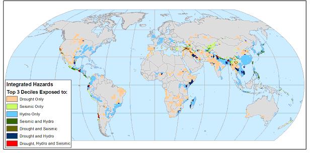

10 Natural Disasters Hotspots


11 Multi-Hazard Assessment of Urban Areas Utilized global database of major natural hazards to develop risk profiles faced by specific urban areas. Combined data of interest into an aggregated risk indicator to permit comparison of urban areas. Detailed risk maps and tabular data for key urban areas of interest A tool for comparing and ranking specific cities


12 Hotspots Analysis Used Extensively in World Bank IEG Report Hotspots becoming part of World Bank s terminology Used as basis for a major study of Bank s handling of assistance in disaster recovery and reconstruction Hotspots data suggested as basis for hazard planning of World Bank projects in high risk areas Hotspots report received IEG 2006 Good Practice Award as Initiative with Demonstrated Impact/Results When formulating country lending programs, the Bank needs to elevate the importance of disasters, especially for highly vulnerable countries. To do this efficiently, borrowing countries would have to be divided into categories according to their disaster risk levels. Using the list of hotspot countries in the Natural Disaster Hotspots study as a starting point, 35 countries have a high vulnerability, because 50 percent or more of their GDP is classed as being at risk from natural disasters in the report. Fifteen countries have a medium vulnerability to natural disasters because natural disasters could place between 30 and 50 percent of their GDP at risk


13 Poverty Mapping Data Global, national, and subnational data on poverty developed in collaboration with the World Bank Development Economics Data Group

14 Last of the Wild/Human Footprint


15 NASA HANPP Data Human Appropriation of Net Primary Productivity (HANPP) dataset developed by M. Imhoff et al. at GSFC 0.25 grid NPP, HANPP, and HANPP as percent of NPP Tabular dataset by country on total estimated consumption of NPP Originally published in Nature in
 data IS92")

16 IPCC Socioeconomic Data Distribution Centre Special Report on Emissions Scenarios (SRES) data IS92 scenarios Baseline socioeconomic datasets Possible new scenario data activities

17 Mapping Emerging Diseases


18 SEDAC Long-Term Archive Collaboration with Columbia University Library System Mission: The SEDAC Long-Term Archive acquires, preserves, and maintains the content of selected high-quality data, data products, documentation, and services relevant to human dimensions of global change in a digital form to support the discovery, access, and use of archived resources by scientific, educational, and decision-making communities for at least the next 50 years. Currently being implemented using Fedora, an open source digital object repository and asset management system


19 Data Management and Policy Lead role in developing guidelines for implementing the GEO Data Sharing Principles Working with CODATA, Creative Commons, GBIF, others on open access data policies & licensing approaches Working with libraries, NSF, WDCs, Digital Curation Center, and others on long-term data stewardship issues

20 World Data Center Portal Content for 9 thematic areas initially: Climate Conservation Hazards Health Population Poverty Sustainability Treaties Integrates data, maps, news, publications, links, etc. Links to other global data centers & networks

21 Desktop Mapping Application: TerraViva! SEDAC SEDAC version of TerraViva! Global Data Viewer now available Provides visualization of multiple SEDAC and remote sensing datasets in integrated desktop application
 to permit specific preset")

22 Interoperable Map Services Support for WMS, WFS, WCS Supports contexts (WMC) to permit specific preset thematic/regional views Advanced search permits addition of external layers, e.g., via CRS, plus filtering and other functions


")
23 The International Center for AIDS Care and Treatment Program (ICAP)

24 Unified Reporting System

25 Unified Reporting Table

26 Unified Reporting Tables

27 Interactive Mapping Tools for Health Care Management Systems

28 Mapping Themes

29 Site Census

30 Percent HIV tested

31 Context Files and OGC Layers
32 CIESIN Workshop Wednesday, March 19, 9:00 Developing Environmental Indicators Dr. Malanding Jaiteh & Mark Becker
33 SEDAC Mapping Client ICAP Map Viewer
Social Science Data for High Latitudes
 LCLUC Science Team Meeting High Latitudes in the Context of the International Polar Year Social Science Data for High Latitudes 2 May 2008 Dr. Robert S. Chen Director and Senior Research Scientist, CIESIN
SUPPORTS SUSTAINABLE GROWTH
 DDSS BBUUN NDDLLEE G E O S P AT I A L G O V E R N A N C E P A C K A G E SUPPORTS SUSTAINABLE GROWTH www.digitalglobe.com BRISBANE, AUSTRALIA WORLDVIEW-3 30 CM International Civil Government Programs US
Deborah Balk 1,2 Gordon McGranahan 3 Bridget Anderson 2
 Preference and Risks of Coastal Population Distribution: A systematic assessment of population and land area in urban and rural areas of coastal zones. Deborah Balk 1,2 Gordon McGranahan 3 Bridget Anderson
Gridded Population of the World Version 4 (GPWv4)
") Gridded Population of the World Version 4 (GPWv4) Greg Yetman Chris Small Erin Doxsey-Whitfield Kytt MacManus May 28, 2015 Global Urbanization Workshop http://sedac.ciesin.columbia.edu 1 Focus on applying
Gridded Population of the World Version 4 (GPWv4) Greg Yetman Chris Small Erin Doxsey-Whitfield Kytt MacManus May 28, 2015 Global Urbanization Workshop http://sedac.ciesin.columbia.edu 1 Focus on applying
What s new (or not so new) in Population and Poverty Data Initiatives
 in Population and Poverty Data Initiatives") What s new (or not so new) in Population and Poverty Data Initiatives Deborah Balk Global Spatial Data and Information User Workshop 21 September 2004 Evolution in global collection of population and poverty
What s new (or not so new) in Population and Poverty Data Initiatives Deborah Balk Global Spatial Data and Information User Workshop 21 September 2004 Evolution in global collection of population and poverty
Spatially Enabled Society
 International Seminar on Land Administration Trends and Issues in Asia and the Pacific Region Spatially Enabled Society Abbas Rajabifard Vice Chair PCGIAP-WG3 Vice-President (President Elect), GSDI Association
Economic and Social Council
 United Nations Economic and Social Council Distr.: General 18 July 2016 Original: English Committee of Experts on Global Geospatial Information Management Sixth session New York, 3-5 August 2016 Item 2
THE ROLE OF GEOSPATIAL AT THE WORLD BANK
 THE ROLE OF GEOSPATIAL AT THE WORLD BANK INSPIRE Conference Barcelona, Spain September 26, 2016 Kathrine Kelm Senior Land Administration Specialist Global Land and Geospatial Unit The World Bank Group
Compact guides GISCO. Geographic information system of the Commission
 Compact guides GISCO Geographic information system of the Commission What is GISCO? GISCO, the Geographic Information System of the COmmission, is a permanent service of Eurostat that fulfils the requirements
Roadmap to interoperability of geoinformation
 Roadmap to interoperability of geoinformation and services in Europe Paul Smits, Alessandro Annoni European Commission Joint Research Centre Institute for Environment and Sustainability paul.smits@jrc.it
Realizing benefits of Spatial Data Infrastructure A user s perspective from Environment Agency - Abu Dhabi
 Realizing benefits of Spatial Data Infrastructure A user s perspective from Environment Agency - Abu Dhabi Anil Kumar Director, Environment Information Management 26 April 2012 Geospatial World Forum,
Geographic Information Infrastructure and Policy Framework for Sustainable Mountain Development in the Hindu Kush-Himalayas
 Geo SMART ASIA 2017 22-24 August, Kualalampur Geographic Information Infrastructure and Policy Framework for Sustainable Mountain Development in the Hindu Kush-Himalayas Basanta Shrestha, Director Strategic
Foundation Geospatial Information to serve National and Global Priorities
 Foundation Geospatial Information to serve National and Global Priorities Greg Scott Inter-Regional Advisor Global Geospatial Information Management United Nations Statistics Division UN-GGIM: A global
I&CLC2000 in support to new policy initiatives (INSPIRE, GMES,..)
") I&CLC2000 in support to new policy initiatives (INSPIRE, GMES,..) Manfred Grasserbauer, Director Joint Research Centre Institute for Environment and Sustainability 1 IMAGE 2000 European mosaic of satellite
I&CLC2000 in support to new policy initiatives (INSPIRE, GMES,..) Manfred Grasserbauer, Director Joint Research Centre Institute for Environment and Sustainability 1 IMAGE 2000 European mosaic of satellite
Integrating Official Statistics and Geospatial Information NBS Experience
 Integrating Official Statistics and Geospatial Information NBS Experience Presented by Eng. Reda AL Sabbagh Director of IT Dept. Prepared by Eng. Adham Makky GIS Specialist Topics to be covered: Background
Lessons Learned from the production of Gridded Population of the World Version 4 (GPW4) Columbia University, CIESIN, USA EFGS October 2014
 Columbia University, CIESIN, USA EFGS October 2014") Lessons Learned from the production of Gridded Population of the World Version 4 (GPW4) Columbia University, CIESIN, USA EFGS October 2014 Gridded Population of the World Gridded (raster) data product
Lessons Learned from the production of Gridded Population of the World Version 4 (GPW4) Columbia University, CIESIN, USA EFGS October 2014 Gridded Population of the World Gridded (raster) data product
UNITED NATIONS E/CONF.96/CRP. 5
 UNITED NATIONS E/CONF.96/CRP. 5 ECONOMIC AND SOCIAL COUNCIL Eighth United Nations Regional Cartographic Conference for the Americas New York, 27 June -1 July 2005 Item 5 of the provisional agenda* COUNTRY
Climate Resilience Decision Making Framework in the Caribbean. A case of Spatial Data Management
 Climate Resilience Decision Making Framework in the Caribbean A case of Spatial Data Management Bishwa Pandey Sr. Data Management Specialist The World Bank Background The mission of The World Bank s Latin
Identifying Global Natural Disaster Hotspots
 Identifying Global Natural Disaster Hotspots Gregory Yetman and Robert S. Chen Center for International Earth Science Information Network (CIESIN), Columbia University Abstract The World Bank and Columbia
Norwegian spatial data infrastructure supporting disaster risk management Norwegian Mapping Authority
 Norwegian spatial data infrastructure supporting disaster risk management Norwegian Mapping Authority Arvid Lillethun, Norwegian Mapping Authority Land and Poverty 2018 Conference, World Bank 19.-23. March
Oman NSDI Supporting Economic Development. Saud Al-Nofli Director of Spatial Data Directorate General of NSDI, NCSI
 Oman NSDI Supporting Economic Development 2017 Saud Al-Nofli Director of Spatial Data Directorate General of NSDI, NCSI "It s critical to make correct decisions the first time to optimize the Investments
Georeferencing and Satellite Image Support: Lessons learned, Challenges and Opportunities
 Georeferencing and Satellite Image Support: Lessons learned, Challenges and Opportunities Shirish Ravan shirish.ravan@unoosa.org UN-SPIDER United Nations Office for Outer Space Affairs (UNOOSA) UN-SPIDER
Oman NSDI Business Values and Future Directions. Hassan Alawi Alghazali Acting Director General National Spatial Data Infrastructure
 Oman NSDI Business Values and Future Directions Hassan Alawi Alghazali Acting Director General National Spatial Data Infrastructure Presentation Outline Geospatial Maturity Current Challenges NCSI s Role
OCEANOGRAPHIC DATA MANAGEMENT
 OCEANOGRAPHIC DATA MANAGEMENT Presented to: Environmental Disaster Data Management Meeting Russ Beard Director, National Coastal Data Development Center Interim Science Coordinator, Gulf Restoration Council
LandScan Global Population Database
 LandScan Global Population Database The World s Finest Population Distribution Data Uncommon information. Extraordinary places. LandScan Global Population Database East View Cartographic is now offering
Land Accounts - The Canadian Experience
 Land Accounts - The Canadian Experience Development of a Geospatial database to measure the effect of human activity on the environment Who is doing Land Accounts Statistics Canada (national) Component
Oak Ridge Urban Dynamics Institute
 Oak Ridge Urban Dynamics Institute Presented to ORNL NEED Workshop Budhendra Bhaduri, Director Corporate Research Fellow July 30, 2014 Oak Ridge, TN Our societal challenges and solutions are often local
Geography (GEOG) Introduction to Geography Global Change and Natural Disasters and Environmental Change
 Introduction to Geography Global Change and Natural Disasters and Environmental Change") Geography (GEOG) Head of Department: Professor Jeffrey P. Osleeb Department Office: Room 422, Philip E. Austin Building For major requirements, see the College of Liberal Arts and Sciences section of this
Geography (GEOG) Head of Department: Professor Jeffrey P. Osleeb Department Office: Room 422, Philip E. Austin Building For major requirements, see the College of Liberal Arts and Sciences section of this
INDONESIA S S UPDATE: GEOSPATIAL INFORMATION FOR SUSTAINABLE DEVELOPMENT RELATED TO INA SDI Dr. Asep Karsidi, M.Sc
 INDONESIA S S UPDATE: GEOSPATIAL INFORMATION FOR SUSTAINABLE DEVELOPMENT RELATED TO INA SDI Dr. Asep Karsidi, M.Sc GEOSPATIAL INFORMATION AGENCY 08 August, 2012 OUTLINE 1. Transformation Bakosurtanal into
a national geological survey perspective François ROBIDA BRGM (French Geological Survey)
") a national geological survey perspective François ROBIDA BRGM (French Geological Survey) Pre-Conference Seminar on Socio-Economic Value of Geospatial for National and Regional Development 21 August 2017,
a national geological survey perspective François ROBIDA BRGM (French Geological Survey) Pre-Conference Seminar on Socio-Economic Value of Geospatial for National and Regional Development 21 August 2017,
Regional EGM on Community of Practice of Georeferenced Information System. for Disaster Risk Management (Geo-DRM) April 2014, Bangkok, Thailand
 April 2014, Bangkok, Thailand") Regional EGM on Community of Practice of Georeferenced Information System for Disaster Risk Management (Geo-DRM) 23-25 April 2014, Bangkok, Thailand Presented By Mukesh Kumar Keshari Ministry of Home Affairs
Regional EGM on Community of Practice of Georeferenced Information System for Disaster Risk Management (Geo-DRM) 23-25 April 2014, Bangkok, Thailand Presented By Mukesh Kumar Keshari Ministry of Home Affairs
Introducing the. a partnership of
 Introducing the a partnership of Background Need for online atlas identified by managers and researchers to make coastal data available Shoreline data Ocean and coastal resources Sea-level rise potential
DEPARTMENT OF GEOGRAPHY B.A. PROGRAMME COURSE DESCRIPTION
 DEPARTMENT OF GEOGRAPHY B.A. PROGRAMME COURSE DESCRIPTION (3 Cr. Hrs) (2340100) Geography of Jordan (University Requirement) This Course pursues the following objectives: - The study the physical geographical
Integration for Informed Decision Making
 Geospatial and Statistics Policy Intervention: Integration for Informed Decision Making Greg Scott Global Geospatial Information Management United Nations Statistics Division Department of Economic and
US National Spatial Data Infrastructure A Spatial Framework for Governance and Policy Development to Enable a Location-Based Digital Ecosystem
 GeoPlatform Workshop 7 Dec 2016, Department of the Interior Washington, D.C. US National Spatial Infrastructure A Spatial Framework for Governance and Policy Development to Enable a Location-Based Digital
Geological information for Europe : Towards a pan-european Geological Data Infrastructure
 Geological information for Europe : Towards a pan-european Geological Data Infrastructure Integrating geoscientific information for EU competitiveness Co-funded by the European Union European societal
ArcGIS for INSPIRE. Marten Hogeweg
 ArcGIS for INSPIRE Marten Hogeweg Please Take Our Survey on the App Download the Esri Events app and find your event Select the session you attended Scroll down to find the feedback section Complete answers
Economic and Social Council
 United Nations Economic and Social Council Distr.: General 2 July 2012 E/C.20/2012/10/Add.1 Original: English Committee of Experts on Global Geospatial Information Management Second session New York, 13-15
GIS (GEOGRAPHICAL INFORMATION SYSTEMS) AS A FACILITATION TOOL FOR SUSTAINABLE DEVELOPMENT IN AFRICA
 AS A FACILITATION TOOL FOR SUSTAINABLE DEVELOPMENT IN AFRICA") GIS (GEOGRAPHICAL INFORMATION SYSTEMS) AS A FACILITATION TOOL FOR SUSTAINABLE DEVELOPMENT IN AFRICA a presentation by Elizabeth Hicken GDEST Conference on Geospatial Sciences for Sustainable Development
GIS (GEOGRAPHICAL INFORMATION SYSTEMS) AS A FACILITATION TOOL FOR SUSTAINABLE DEVELOPMENT IN AFRICA a presentation by Elizabeth Hicken GDEST Conference on Geospatial Sciences for Sustainable Development
Geospatial Technologies for Resources Planning & Management
 Geospatial Technologies for Resources Planning & Management Lal Samarakoon, PhD Director, Geoinformatics Center Asian Institute of Technology, Thailand Content Geoinformatics for SDG Information Integration
Key Points Sharing fosters participation and collaboration Metadata has a big role in sharing Sharing is not always easy
 Sharing Resources Geoff Mortson esri, Inc. SDI Solutions Team Key Points Sharing fosters participation and collaboration Metadata has a big role in sharing Sharing is not always easy Data Sharing is Good
Spatial Data Infrastructure Concepts and Components. Douglas Nebert U.S. Federal Geographic Data Committee Secretariat
 Spatial Data Infrastructure Concepts and Components Douglas Nebert U.S. Federal Geographic Data Committee Secretariat August 2009 What is a Spatial Data Infrastructure (SDI)? The SDI provides a basis for
Discovery and Access of Geospatial Resources using the Geoportal Extension. Marten Hogeweg Geoportal Extension Product Manager
 Discovery and Access of Geospatial Resources using the Geoportal Extension Marten Hogeweg Geoportal Extension Product Manager DISCOVERY AND ACCESS USING THE GEOPORTAL EXTENSION Geospatial Data Is Very
UN-GGIM Arab States Meeting Welcome Address. Denise McKenzie Open Geospatial Consortium 21 February 2017 Doha, Qatar
 UN-GGIM Arab States Meeting Welcome Address Denise McKenzie Open Geospatial Consortium 21 February 2017 Doha, Qatar The Open Geospatial Consortium Not-for-profit, international voluntary consensus standards
Summary of Available Datasets that are Relevant to Flood Risk Characterization
 Inter-Agency Characterization Workshop February 25-27, 2014 USACE Institute for Water Resources, Alexandria, VA, IWR Classroom Summary of Available Datasets that are Relevant to Characterization National
Disaster Prevention and Management in Asia: The Context of Human Security and Its Relevance to Infrastructure Planning and Management
 Disaster Prevention and Management in Asia: The Context of Human Security and Its Relevance to Infrastructure Planning and Management Rajib Shaw http://www.iedm.ges.kyoto-u.ac.jp/ Contents Background and
Marine Spatial Planning, a Norwegian user case NSHC33
 Marine Spatial Planning, a Norwegian user case NSHC33 Marine Spatial Management Tool Support the marine spatial planning process with updated and reliable geospatial information Marine management is important
A Framework for the Study of Urban Health. Abdullah Baqui, DrPH, MPH, MBBS Johns Hopkins University
 This work is licensed under a Creative Commons Attribution-NonCommercial-ShareAlike License. Your use of this material constitutes acceptance of that license and the conditions of use of materials on this
Overview. Gulf of Mexico Alliance Ocean and Coastal Mapping Regional Ecosystem Data Management (REDM) Q2O (QARTOD to OGC) Things to Consider
 Q2O (QARTOD to OGC) Things to Consider") 1 Overview Gulf of Mexico Alliance Ocean and Coastal Mapping Regional Ecosystem Data Management (REDM) Q2O (QARTOD to OGC) Things to Consider 2 Gulf Of Mexico Alliance Partnership of the states of Alabama,
1 Overview Gulf of Mexico Alliance Ocean and Coastal Mapping Regional Ecosystem Data Management (REDM) Q2O (QARTOD to OGC) Things to Consider 2 Gulf Of Mexico Alliance Partnership of the states of Alabama,
What s new in GIS. RAL Retreat Oct 5, 2005
 What s new in GIS RAL Retreat Oct 5, 2005 Overview GIS Initiative milestones Major activities in 2004-2005 GALEON UNIDATA OGC project New functionality in ESRI software GIS Initiative Team Olga Wilhelmi
2018/1 The integration of statistical and geospatial information. The Regional Committee of UN-GGIM: Americas:
 The following are the conclusions and recommendations of the Regional Committee of the United Nations on Global Geospatial Information Management for the Americas, during its Fifth Session, Thursday 8
SDI DEVELOPMENT UPDATES OF INDONESIA
 SDI DEVELOPMENT UPDATES OF INDONESIA DR. ANTONIUS B. WIJANARTO Center For Management And Dissemination Of Geospatial Information GEOSPATIAL INFORMATION AUTHORITY GOVERNMENT OF THE REPUBLIC OF INDONESIA
Cooperating Organization Report of Circum Pacific Council for Energy and Mineral Resources (CPC)
") CCOP-41AS/6.2-29 Coordinating Committee for Geoscience Programmes in East and Southeast Asia (CCOP) 41 st CCOP Annual Session 15 18 November 2004 Tsukuba, Japan Cooperating Organization Report of Circum
CCOP-41AS/6.2-29 Coordinating Committee for Geoscience Programmes in East and Southeast Asia (CCOP) 41 st CCOP Annual Session 15 18 November 2004 Tsukuba, Japan Cooperating Organization Report of Circum
Geospatial Information and Services for Disasters (GIS4D)
") Geospatial Information and Services for Disasters (GIS4D) 31 July 2017 Tae Hyung KIM ICT and Disaster Risk Reduction Division (IDD) UNESCAP 1 About ESCAP Who is ESCAP? United Nations Economic and Social
Geospatial Information and Services for Disasters (GIS4D) 31 July 2017 Tae Hyung KIM ICT and Disaster Risk Reduction Division (IDD) UNESCAP 1 About ESCAP Who is ESCAP? United Nations Economic and Social
Disaster Management & Recovery Framework: The Surveyors Response
 Disaster Management & Recovery Framework: The Surveyors Response Greg Scott Inter-Regional Advisor Global Geospatial Information Management United Nations Statistics Division Department of Economic and
SDI and Beyond The Importance of Standards and Interoperability For Good Governance; Selected Examples
 SDI and Beyond The Importance of Standards and Interoperability For Good Governance; Selected Examples Trevor Taylor, Director, Member Services, Asia and the Americas Sao Paulo May 7 th, 2014 Why is Geospatial
GIS Visualization: A Library s Pursuit Towards Creative and Innovative Research
 GIS Visualization: A Library s Pursuit Towards Creative and Innovative Research Justin B. Sorensen J. Willard Marriott Library University of Utah justin.sorensen@utah.edu Abstract As emerging technologies
Jim Fox. copyright UNC Asheville's NEMAC
 Decisions and System Thinking Jim Fox November, 2012 1 UNC Asheville s s NEMAC National Environmental Modeling and Analysis Center Applied Research and technology development on integration of environmental
Spatial decision making in Armenia based on multidisciplinary environmental research
 EU FP7 EcoArm2ERA Integration into ERA Integration of spatial decision support systems and evidence based modeling in National/Regional Policy applications and regulatory systems: scientific and policy
The Efforts of Building GIS Infrastructure in a Newly Independent State: The case of Timor Leste *
 UNITED NATIONS E/CONF.100/IP.12 ECONOMIC AND SOCIAL COUNCIL Eighteenth United Nations Regional Cartographic Conference for Asia and the Pacific Bangkok, 26-29 October 2009 Item 7(b) of the provisional
Introduction: The Gulf of Mexico Alliance. The Gulf GAME project MERMAid and PHINS Results & Conclusions What s next? Examples
 AAG Las Vegas March 25, 2009 Introduction: Ocean governance and Ecosystem-Based Management The Gulf of Mexico Alliance Habitat Identification and Characterization The Gulf GAME project MERMAid and PHINS
UNIVERSITY OF SPATIAL ENGINEERING. PROF. DR. VICTOR JETTEN DRS. TINY LUITEN MBA
 UNIVERSITY OF SPATIAL ENGINEERING. PROF. DR. VICTOR JETTEN DRS. TINY LUITEN MBA 5. PRACTICAL INFO 1. WHY ON EARTH SPATIAL ENGINEERING? 4. WHAT IS THERE AFTER YOU FINISH? 2. WHAT CAN YOU DO? 3. HOW TO BECOME
African Coastal Atlas developments. 10 July 2008 EEA Copenhagen, Denmark
 African Coastal Atlas developments 10 July 2008 EEA Copenhagen, Denmark Africa Overview Africa has approximately 40 000 km of coast across 32 mainland countries and four island states. Africa's coastal
Imagery and the Location-enabled Platform in State and Local Government
 Imagery and the Location-enabled Platform in State and Local Government Fred Limp, Director, CAST Jim Farley, Vice President, Leica Geosystems Oracle Spatial Users Group Denver, March 10, 2005 TM TM Discussion
Use of geo-referenced data for DRM in Central Asia, problems and prospective
 Use of geo-referenced data for DRM in Central Asia, problems and prospective Dr. Akylbek Chymyrov Director, Kyrgyz Center of Geoinformation Systems Member of the Public Supervisory Board MES KR KSUCTA,
Liana Talaue McManus. Division of Marine Affairs and Policy Rosenstiel School of Marine & Atmospheric Science University of Miami
 Liana Talaue McManus Division of Marine Affairs and Policy Rosenstiel School of Marine & Atmospheric Science University of Miami Outline 1. Coasts as vulnerable & resilient social ecological systems 2.
Study on Data Integration and Sharing Standard and Specification System for Earth System Science
 Study on Data Integration and Sharing Standard and Specification System for Earth System Science Juanle Wang and Jiulin Sun Information Sharing Center for Earth System Science Institute of Geographic Sciences
Digital Map of Mexico Platform and MxSIG. March 2017
 Digital Map of Mexico Platform and MxSIG March 2017 1 I. Digital Map of Mexico Platform Concept Evolution II. Digital Map of Mexico online Concept Capabilities Information available Other state units information
Proposal for a DIRECTIVE OF THE EUROPEAN PARLIAMENT AND OF THE COUNCIL. establishing an infrastructure for spatial information in the Community
 Proposal for a DIRECTIVE OF THE EUROPEAN PARLIAMENT AND OF THE COUNCIL establishing an infrastructure for spatial information in the Community INSPIRE http://inspire.jrc.it/ Alessandro Annoni 1 EU Commission
The PREVIEW Global Risk Data Platform: a geoportal to serve and share global data on risk to natural hazards
 The PREVIEW Global Risk Data Platform: a geoportal to serve and share global data on risk to natural hazards Gregory Giuliani (UNEP/GRID-Geneva & University of Geneva/enviroSPACE ) http://www.grid.unep.ch
The UN-GGIM: Europe core data initiative to encourage Geographic information supporting Sustainable Development Goals Dominique Laurent, France
 INSPIRE conference Strasbourg 6 September 2017 The UN-GGIM: Europe core data initiative to encourage Geographic information supporting Sustainable Development Goals Dominique Laurent, France Introduction
Egypt Public DSS. the right of access to information. Mohamed Ramadan, Ph.D. [R&D Advisor to the president of CAPMAS]
![Egypt Public DSS. the right of access to information. Mohamed Ramadan, Ph.D. [R&D Advisor to the president of CAPMAS]](/thumbs/89/98483713.jpg "Egypt Public DSS. the right of access to information. Mohamed Ramadan, Ph.D. [R&D Advisor to the president of CAPMAS]") Egypt Public DSS ì the right of access to information Central Agency for Public Mobilization and Statistics Arab Republic of Egypt Mohamed Ramadan, Ph.D. [R&D Advisor to the president of CAPMAS] Egypt
Egypt Public DSS ì the right of access to information Central Agency for Public Mobilization and Statistics Arab Republic of Egypt Mohamed Ramadan, Ph.D. [R&D Advisor to the president of CAPMAS] Egypt
THE USE OF GEOSPATIAL DATA TO SUPPORT VULNERABILITY MAPPING OF THE OREGON COAST. Kelvin Raiford MS Candidate Geography Department of Geosciences
 THE USE OF GEOSPATIAL DATA TO SUPPORT VULNERABILITY MAPPING OF THE OREGON COAST Kelvin Raiford MS Candidate Geography Department of Geosciences INTRODUCTION This study is an outcome of the project Geospatial
EuroGEOSS Protected Areas Pilot
 EuroGEOSS Protected Areas Pilot Max Craglia European Commission Joint Research Centre Part 1: the present MyNatura2000 Mobile app. Awareness raising & volunteered data collection. Natura2000 covers 18%
Copernicus Overview. Major Emergency Management Conference Athlone 2017
 Copernicus Overview Major Emergency Management Conference Athlone 2017 Copernicus is a European programme implemented by the European Commission. The services address six thematic areas: land, marine,
Systems (GIS) - with a focus on.
 - with a focus on.") Introduction to Geographic Information Systems (GIS) - with a focus on localizing the MDGs Carmelle J. Terborgh, Ph.D. ESRI www.esri.com Flying Blind Jul 24th 2003 The Economist We Live in Two Worlds Natural
Introduction to Geographic Information Systems (GIS) - with a focus on localizing the MDGs Carmelle J. Terborgh, Ph.D. ESRI www.esri.com Flying Blind Jul 24th 2003 The Economist We Live in Two Worlds Natural
Progress on the Development of the Strategic Framework on Geospatial Information and Services for Disasters
 Progress on the Development of the Strategic Framework on Geospatial Information and Services for Disasters Dr. Peter N. Tiangco Administrator, NAMRIA, Philippines Co-chair, Working Group on Geospatial
We recommend you cite the published version. The publisher s URL is:
 Ludlow, D. and Khan, Z. (2011) GMES and INSPIRE: Harmonising cross-thematic environmental data for integrated intelligence. In: 2nd GMES Operational Workshop, Sofia, Bulgaria, 17th - 18th March 2011. Available
Introduction. Elevation Data Strategy. Status and Next Steps
 1 2 Introduction Elevation Data Strategy Status and Next Steps 3 Canada is the 2nd largest country in the world - 9.9 million sq km Surrounded by 3 oceans with 202 000 km of coastline Population over 35
Applied Geoscience and Technology Division SOPAC. Joy Papao, Risk Information Systems Officer
 Joy Papao, Risk Information Systems Officer Secretariat of the Pacific Community SPC 22 Pacific Island States Head office in Noumea, New Caledonia 2 Regional offices (Pohnpei and Honiara) 600 staff 9 Technical
DEPARTMENT OF GEOLOGY AND MINERAL INDUSTRIES WAYS & MEANS SUBCOMMITTEE ON NATURAL RESOURCES MARCH 2, 2017
 DEPARTMENT OF GEOLOGY AND MINERAL INDUSTRIES WAYS & MEANS SUBCOMMITTEE ON NATURAL RESOURCES MARCH 2, 2017 1 ABOUT DOGAMI AGENCY MISSION, VISION & GOALS 2 Lidar image of a stream network along the Umpqua
TOWARDS CLIMATE-RESILIENT COASTAL MANAGEMENT: OPPORTUNITIES FOR IMPROVED ICZM IN BELIZE
 TOWARDS CLIMATE-RESILIENT COASTAL MANAGEMENT: OPPORTUNITIES FOR IMPROVED ICZM IN BELIZE CHANTALLE SAMUELS Coastal Zone Management Authority and Institute The Caribbean Community Climate Change Centre VULNERABILITY
Observation (EO) & Geomatics in Canada
 & Geomatics in Canada") Innovating to Increase the Impact of Earth Observation (EO) & Geomatics in Canada Natural Resources Canada February 25, 2014 Prashant Shukle, Director General Canada Centre for Mapping and Earth Observation
Innovating to Increase the Impact of Earth Observation (EO) & Geomatics in Canada Natural Resources Canada February 25, 2014 Prashant Shukle, Director General Canada Centre for Mapping and Earth Observation
Using OGC standards to improve the common
 Using OGC standards to improve the common operational picture Abstract A "Common Operational Picture", or a, is a single identical display of relevant operational information shared by many users. The
Prairie Climate Centre Prairie Climate Atlas. Visualizing Climate Change Projections for the Canadian Prairie Provinces
 Prairie Climate Centre Prairie Climate Atlas Visualizing Climate Change Projections for the Canadian Prairie Provinces Acknowledgements About Us Dr. Danny Blair Dr. Ian Mauro Ryan Smith, MSc Dr. Hank Venema
Major Opportunities in Spatial Data Infrastructure Communities
 Major Opportunities in Spatial Data Infrastructure Communities Bas Kok President GSDI June 17 th 2008 FIG Working Week: Integrating Generations 14-19 June 2008 Stockholm, Sweden http://www.gsdi.org 1 GSDI
Institute of Statistical and Geographical Information of Jalisco State Subnational Statistical and Geographical System India.
 Institute of Statistical and Geographical Information of Jalisco State Subnational Statistical and Geographical System India. January 2017 Subnational Statistical and Geographical System National Statistical
Plenary Session 2, part 2 A European shared information system
 3 rd GMES Forum 5 6 June 2003 Athens Plenary Session 2, part 2 A European shared information system Gordon McInnes Deputy Director European Environment Agency 1 I keep six honest serving men. They taught
INSPIRing Geospatial Framework For Local Administrations
 This project is financed by the European Union and the Republic of Turkey Presented at the FIG Congress 2018, May 6-11, 2018 in Istanbul, Turkey National Programme for Turkey 2010 Instrument for Pre-Accession
Copernicus Overview and Emergency Management Service
 Copernicus Overview and Emergency Management Service Frédéric BASTIDE European Commission Open informal session of the United Nations Inter-Agency Meeting on Outer Space Activities 12 March 2013, Geneva
GMES Service for Geospatial Reference Data Access (RDA) Covering Areas Outside Europe
 Covering Areas Outside Europe") INSPIRE Conference 2011 Edinburgh 27 June - 1 July GMES Service for Geospatial Reference Data Access (RDA) Covering Areas Outside Europe Andrea Ajmar, Simone Balbo, Piero Boccardo, Simone Dalmasso, Anna
INSPIRE Conference 2011 Edinburgh 27 June - 1 July GMES Service for Geospatial Reference Data Access (RDA) Covering Areas Outside Europe Andrea Ajmar, Simone Balbo, Piero Boccardo, Simone Dalmasso, Anna
From the Venice Lagoon Atlas towards a collaborative federated system
 From the Venice Lagoon Atlas towards a collaborative federated system City of Venice Alessandro Mulazzani CORILA Consortium for Coordination of Research Activities Concerning the Venice Lagoon System ISMAR-CNR
Advancing Geoscientific Capability. Geological Survey of Finland
 Advancing Geoscientific Capability Geological Survey of Finland GTK in brief The Geological Survey of Finland (GTK) is one of the largest European centres of excellence in assessment, research and the
Supporting GPSC Cities with Satellite Earth Observation for Sustainable Urban Development
 Supporting GPSC Cities with Satellite Earth Observation for Sustainable Urban Development Global Platform for Sustainable Cities African Regional Workshop 14 May 2018 AfDB Headquarters Abidjan, Côte d'ivoire
Geospatial Information Management in the Americas: Lessons for the Post-2015 development agenda
 Geospatial Information Management in the Americas: Lessons for the Post-2015 development agenda Rolando Ocampo President, UN-GGIM: Americas October 2014 The integration of statistical and geographical
Kentucky Collaborates in GeoMAPP Project: The Advantages and Challenges of Archiving in a State with a Centralized GIS
 Kentucky Collaborates in GeoMAPP Project: The Advantages and Challenges of Archiving in a State with a Centralized GIS Geospatial Multistate Archive and Preservation Partnership By Glen McAninch Best Practices
Work Group A «Core Data» Report and Update François Chirié, Dominique Laurent, France
 JOINT UN-GGIM: EUROPE ESS MEETING ON THE INTEGRATION OF STATISTICAL AND GEOSPATIAL INFORMATION LUXEMBOURG 11 MARCH 2016 Work Group A «Core Data» Report and Update François Chirié, Dominique Laurent, France
THE DATA REVOLUTION HAS BEGUN On the front lines with geospatial data and tools
 THE DATA REVOLUTION HAS BEGUN On the front lines with geospatial data and tools Slidedoc of presentation for MEASURE Evaluation End of Project Meeting Washington DC May 22, 2014 John Spencer Geospatial
By Lillian Ntshwarisang Department of Meteorological Services Phone:
 By Lillian Ntshwarisang Department of Meteorological Services Phone: +267 3612200 Email: lntshwarisang@gov.bw/ lntshwarisang@gmail.com Introduction Mandate of DMS Function of the Department Services to
Module 3 Indicator Land Consumption Rate to Population Growth Rate
 Regional Training Workshop on Human Settlement Indicators Module 3 Indicator 11.3.1 Land Consumption Rate to Population Growth Rate Dennis Mwaniki Global Urban Observatory, Research and Capacity Development