Gridded Population of the World Version 4 (GPWv4)
|
|
|
- Allen McDonald
- 6 years ago
- Views:
Transcription

1 Gridded Population of the World Version 4 (GPWv4) Greg Yetman Chris Small Erin Doxsey-Whitfield Kytt MacManus May 28, 2015 Global Urbanization Workshop 1


2 Focus on applying information technology to pressing interdisciplinary data, information, and research problems related to human interactions in the environment
")


3 Socioeconomic Data & Applications Center (SEDAC) Focus on human dimensions of environmental change Integration of social and earth science data, especially with remote sensing Direct support to scientists, applied and operational users, decision makers, and policy communities 3


4 Gridded Population of the World Gridded (raster) data product developed to provide a spatially-disaggregated population surface that is compatible with data sets from social, economic, and Earth science fields. Census population data are transformed from their native spatial units to a global grid of quadrilateral latitude-longitude cells (Balk et al. 2010) Free and openly available GPW version 3, 2000 population density Transforming census units to a grid

5 History of GPW GPWv1 was an outgrowth of a Global Demography Workshop held at CIESIN in 1994 Consensus that a consistent global database of population totals in raster format would be invaluable for interdisciplinary study (Deichmann et al., 2001) Produced by Waldo Tobler, Uwe Deichmann, Jon Gottsegen, and Kelly Maloy at the UC Santa Barbara


6 Development of GPW Publication Year Years of Estimation Grid Resolution Number of Input Units (subnational geographic units) Census variables Population Density Grid GPWv arc-minutes 19,000 Total Population 1994 GPWv , arc-minutes 127,000 Total Population 1995 GPWv , 1995, arc-minutes ~ 400,000 Total Population 2000 GPWv , 2005, 2010, 2015, arc-seconds (1 km) ~ 12,500,000 Total Population, Sex, Age, Urban/Rural status 2010
7 Basic Workflow Diagram Find tabular population counts and geographic boundaries Proportionally allocate population to 1 km grids using an areal-weighting method Match to geographic boundaries (census or administrative) Adjust estimates to UN World Population Prospects for target years Adjust boundaries to global framework and mask inland water Estimate the population for target years (2000, 2005, 2010, 2015, 2020)
8 Census Statistics Although tabular census data is available in most countries, the format and structure of the data varies. Primary method of census data dissemination Percent of respondents (121 countries) Acquisition Methods in GPW v4 1. Many countries were acquired through basic web research Paper publications 52% Static web pages (html, excel, PDF) Interactive online databases 28% 14% CD/DVD 4% Other 2% Source: 2011/2012 survey for the review of the 2010 World Programme on Population and Housing Censuses; UN Statistics Division, Other countries required more intensive personal communications ( , phone) 3. Still others could not be acquired without the assistance of in-country contacts and networks 4. In some other cases the data were licensed through purchase agreements
9 Evaluation of Census Data Quality GPWv4 will include national level metadata and other qualitative indicators which will inform users of: 1. The currency of the population data 2. Whether the data is from estimate, preliminary, or final census 3. Coverage errors evaluated in post-enumeration surveys Coherence Interpretability Relevance Census Quality Accuracy Timeliness Accessibility

10 Boundary Matching GADMv2 BRA Level 5 Boundaries From IGBE Santana do Livramento Rivera URY Level 3 Boundaries from INE
 and pixels that also contain land (Partial Water")
11 Data Quality Indicators: Water Mask Distinguishes between pixels that are completely water and/or ice (Total Water Pixels) and pixels that also contain land (Partial Water Pixels).

12 Data Quality Indicators: Data Context Categorizes pixels with a 0 population estimate in the population count and density grids, based on information included in the census documents.
13 Additional data sets Data Quality Indicators: Mean Admin Unit Area The mean unit area data provides a quantitative surface that indicates the size of the input unit(s) from which population count and density grids are derived. State/Territory Identifier Grid The identifier boundary data are derived from the pixels as polygons and thus have rectilinear boundaries at large scale. Centroids Estimates of human population counts and densities for the years 2000, 2005, 2010, 2015, and 2020 by administrative unit centroid location.
14 Number of Countries Increased resolution of input census units Frequency of Administrative Level Used GPWv3 GPWv4 # of countries at Level 3 or higher: GPWv3: 47 GPWv4: Administrative Level Used As of Oct 2014 Country Census block

15 Improvements in Input Data Resolution As of Oct countries 132 countries 98 countries
16 Addition of gridded census variables Demand to include demographic information in global population grids GPWv4 will include detailed global grids for: Sex Age 5-year age groups Urban/Rural status


17 Addition of gridded census variables % Rural population, 2010, Panama % Urban population, 2010, Panama


18 SEDAC Population Estimation Service Web-based tool for estimating population totals and related statistics from a user-defined region Uses GPWv3 dataset for the year 2005; will be updated with GPWv4

19 GPWv4: Population Density
20 Additional Modeling: GHSL Integration with GHSL via a joint project with JRC Details to follow in 2016
21 Additional Modeling: VIIRS Day-Night band from the joint NASA-JAXA Suomi NPP satellite Detects lights with greater sensitivity than DMSP at a finer resolution (~300m) Working with beta lights composites Final annual composites of stable lights scheduled for October 2015 Relationship between high resolution census data (population density) and emitted lights
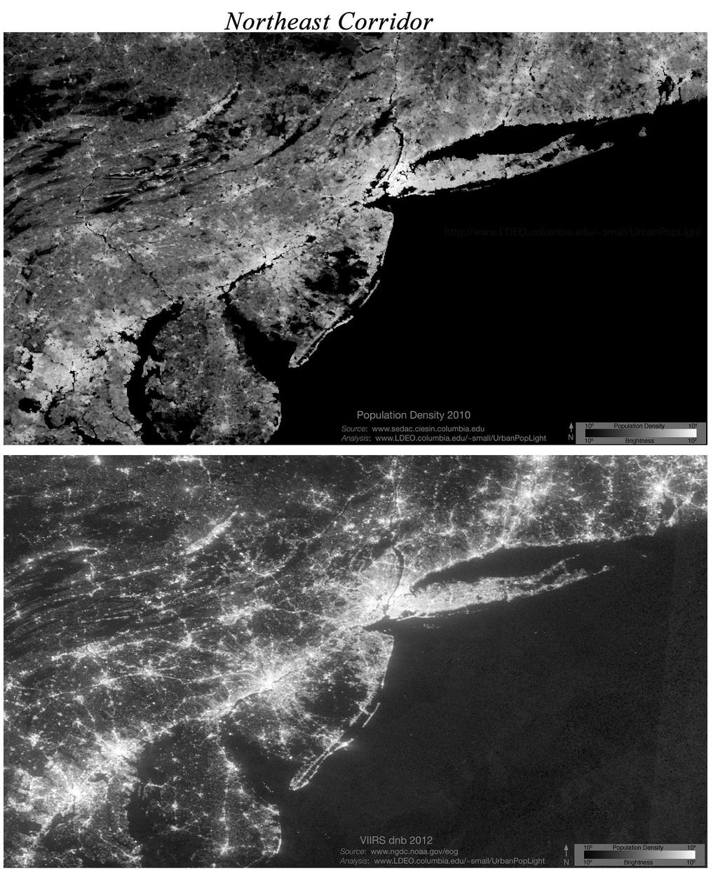
22
23
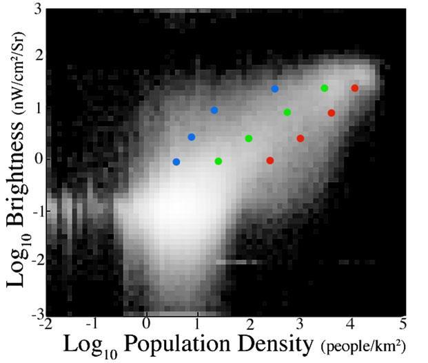
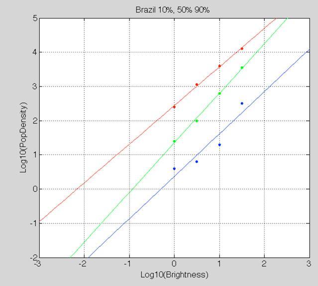
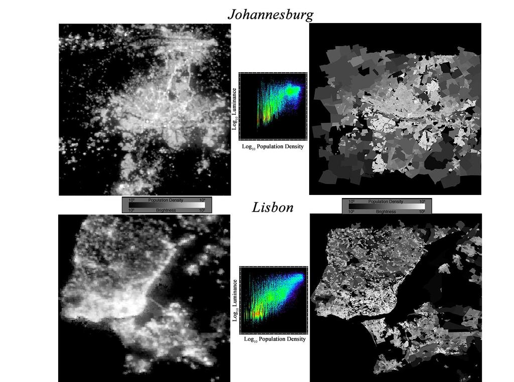
24 Population-Light Relationship

25 Test Case: Guinea VIIRS Reallocation Proportional Allocation

26 Proportional Allocation Height Proportional to Population Counts

27 VIIRS Reallocation Height Proportional to Population Counts
28 GPW is a census-based global population grid that is: Free and open source Well-documented Transparent Highly used Widely applicable How to access data: GPWv3: GPWv4: gpw@ciesin.columbia.edu to request alpha data Greg Yetman gyetman@ciesin.columbia.edu
Lessons Learned from the production of Gridded Population of the World Version 4 (GPW4) Columbia University, CIESIN, USA EFGS October 2014
 Columbia University, CIESIN, USA EFGS October 2014") Lessons Learned from the production of Gridded Population of the World Version 4 (GPW4) Columbia University, CIESIN, USA EFGS October 2014 Gridded Population of the World Gridded (raster) data product
Lessons Learned from the production of Gridded Population of the World Version 4 (GPW4) Columbia University, CIESIN, USA EFGS October 2014 Gridded Population of the World Gridded (raster) data product
Globally Estimating the Population Characteristics of Small Geographic Areas. Tom Fitzwater
 Globally Estimating the Population Characteristics of Small Geographic Areas Tom Fitzwater U.S. Census Bureau Population Division What we know 2 Where do people live? Difficult to measure and quantify.
BASE FOR. New York CIES. in this paper Nations or
 UNITED NATIONS N EXPERT GROUP MEETING ON STRENGTHENING THE DEMOGRAPHIC EVIDENCE BASE FOR THE POST-2015 DEVELOPMENT AGENDA Population Division Department of Economic and Social Affairs United Nations Secretariat
Documentation for the Gridded Population of the World, Version 4 (GPWv4), Revision 10 Data Sets
, Revision 10 Data Sets") Abstract Documentation for the Gridded Population of the World, Version 4 (GPWv4), Revision 10 Data Sets November 2017 Center for International Earth Science Information Network (CIESIN) Columbia University
Abstract Documentation for the Gridded Population of the World, Version 4 (GPWv4), Revision 10 Data Sets November 2017 Center for International Earth Science Information Network (CIESIN) Columbia University
GEOGRAPHIC INFORMATION SYSTEMS Session 8
 GEOGRAPHIC INFORMATION SYSTEMS Session 8 Introduction Geography underpins all activities associated with a census Census geography is essential to plan and manage fieldwork as well as to report results
MODELING THE DISTRIBUTION OF HUMAN POPULATION WITH NIGHT-TIME SATELLITE IMAGERY AND GRIDDED POPULATION OF THE WORLD INTRODUCTION
 MODELING THE DISTRIBUTION OF HUMAN POPULATION WITH NIGHT-TIME SATELLITE IMAGERY AND GRIDDED POPULATION OF THE WORLD Francesca Pozzi, CIESIN Christopher Small, Lamont-Doherty Earth Observatory Gregory Yetman,
GIS Methodology in Determining Population Centers and Distances to Nuclear Power Plants
 GIS Methodology in Determining Population Centers and Distances to Nuclear Power Plants Tine Ningal & Finbarr Brereton The methods used to determine the population centres are described below. The default
LandScan Global Population Database
 LandScan Global Population Database The World s Finest Population Distribution Data Uncommon information. Extraordinary places. LandScan Global Population Database East View Cartographic is now offering
CIESIN Overview: Human-Environment Research and Data Mark Becker Associate Director, Geospatial Applications Division
 CIESIN Overview: Human-Environment Research and Data Mark Becker Associate Director, Geospatial Applications Division Center for International Earth Science Information Network The Earth Institute, Columbia
An Introduction to China and US Map Library. Shuming Bao Spatial Data Center & China Data Center University of Michigan
 An Introduction to China and US Map Library Shuming Bao Spatial Data Center & China Data Center University of Michigan Current Spatial Data Services http://chinadataonline.org China Geo-Explorer http://chinageoexplorer.org
What s new (or not so new) in Population and Poverty Data Initiatives
 in Population and Poverty Data Initiatives") What s new (or not so new) in Population and Poverty Data Initiatives Deborah Balk Global Spatial Data and Information User Workshop 21 September 2004 Evolution in global collection of population and poverty
What s new (or not so new) in Population and Poverty Data Initiatives Deborah Balk Global Spatial Data and Information User Workshop 21 September 2004 Evolution in global collection of population and poverty
Integrating Official Statistics and Geospatial Information NBS Experience
 Integrating Official Statistics and Geospatial Information NBS Experience Presented by Eng. Reda AL Sabbagh Director of IT Dept. Prepared by Eng. Adham Makky GIS Specialist Topics to be covered: Background
Understanding China Census Data with GIS By Shuming Bao and Susan Haynie China Data Center, University of Michigan
 Understanding China Census Data with GIS By Shuming Bao and Susan Haynie China Data Center, University of Michigan The Census data for China provides comprehensive demographic and business information
Brazil Paper for the. Second Preparatory Meeting of the Proposed United Nations Committee of Experts on Global Geographic Information Management
 Brazil Paper for the Second Preparatory Meeting of the Proposed United Nations Committee of Experts on Global Geographic Information Management on Data Integration Introduction The quick development of
TOWARDS POPULATION DENSITY RETRIEVAL USING GAS-FLARE CORRECTED DMSP- OLS NIGH-TIME LIGHT OBSERVATIONS
 TOWARDS POPULATION DENSITY RETRIEVAL USING GAS-FLARE CORRECTED DMSP- OLS NIGH-TIME LIGHT OBSERVATIONS ANDI MAYA PURNAMASARI February, 2017 SUPERVISORS: Valentijn Venus, M.Sc.Ing Dr. A.G Toxopeus TOWARDS
Dr. Robert S. Chen Director and Senior Research Scientist
 Human Planet Forum University of Twente, Enschede, The Netherlands, 13-15 September 2017 Dr. Robert S. Chen Director and Senior Research Scientist CIESIN, The Earth Institute, Columbia University NASA
From Census to Grids: Comparing Gridded Population of the World with Swedish Census Records
 The Open Geography Journal, 2012, 5, 1-5 1 Open Access From Census to Grids: Comparing Gridded Population of the World with Swedish Census Records Ola Hall *,1, Emilie Stroh 2 and Fredy Paya 3 1 Department
Techniques for Science Teachers: Using GIS in Science Classrooms.
 Techniques for Science Teachers: Using GIS in Science Classrooms. After ESRI, 2008 GIS A Geographic Information System A collection of computer hardware, software, and geographic data used together for
CountrySTAT REGIONAL BASIC ADMINISTRATOR TRAINING for GCC MEMBER STATES. CountrySTAT STATISTICS COMPONENT
 CountrySTAT REGIONAL BASIC ADMINISTRATOR TRAINING for GCC MEMBER STATES Abu Dhabi, United Arab Emirates (UAE), 26 30 January 2014 CountrySTAT STATISTICS COMPONENT (Concepts, Definitions, Classification,
Vol112, No11 Feb1, 2010 JOURNAL OF GEO2INFORMATION SC IENCE , CBERS IRS - P5, ;, : ; : E2mail: lreis1ac1cn [ 6-13 ]
![Vol112, No11 Feb1, 2010 JOURNAL OF GEO2INFORMATION SC IENCE , CBERS IRS - P5, ;, : ; : E2mail: lreis1ac1cn [ 6-13 ]](/thumbs/91/105645535.jpg "Vol112, No11 Feb1, 2010 JOURNAL OF GEO2INFORMATION SC IENCE , CBERS IRS - P5, ;, : ; : E2mail: lreis1ac1cn [ 6-13 ]") 12 1 2010 2 JOURNAL OF GEO2INFORMATION SC IENCE Vol112, No11 Feb1, 2010, 3, (, 100101) :,,,,,, CBERS IRS - P5, ;,, 20m 1km ;,, CBERS, 200m, 76% ; P5, 100m, 84% : ; ; ; 1 [ 4-5 ], GIS, [ 6-13 ], ( 1995
12 1 2010 2 JOURNAL OF GEO2INFORMATION SC IENCE Vol112, No11 Feb1, 2010, 3, (, 100101) :,,,,,, CBERS IRS - P5, ;,, 20m 1km ;,, CBERS, 200m, 76% ; P5, 100m, 84% : ; ; ; 1 [ 4-5 ], GIS, [ 6-13 ], ( 1995
What are we like? Population characteristics from UK censuses. Justin Hayes & Richard Wiseman UK Data Service Census Support
 What are we like? Population characteristics from UK censuses Justin Hayes & Richard Wiseman UK Data Service Census Support Who are we? Richard Wiseman UK Data Service / Jisc Justin Hayes UK Data Service
Low Elevation Coastal Zone Urban-Rural Population and Land Area Estimates (1990, 2000, 2010, 2100)
") Low Elevation Coastal Zone Urban-Rural Population and Land Area Estimates (1990, 2000, 2010, 2100) Version 2 December 2013 Socioeconomic Data and Applications Center (SEDAC) Center for International Earth
Low Elevation Coastal Zone Urban-Rural Population and Land Area Estimates (1990, 2000, 2010, 2100) Version 2 December 2013 Socioeconomic Data and Applications Center (SEDAC) Center for International Earth
Hennig, B.D. and Dorling, D. (2014) Mapping Inequalities in London, Bulletin of the Society of Cartographers, 47, 1&2,
 Mapping Inequalities in London, Bulletin of the Society of Cartographers, 47, 1&2,") Hennig, B.D. and Dorling, D. (2014) Mapping Inequalities in London, Bulletin of the Society of Cartographers, 47, 1&2, 21-28. Pre- publication draft without figures Mapping London using cartograms The
Hennig, B.D. and Dorling, D. (2014) Mapping Inequalities in London, Bulletin of the Society of Cartographers, 47, 1&2, 21-28. Pre- publication draft without figures Mapping London using cartograms The
Module 3 Indicator Land Consumption Rate to Population Growth Rate
 Regional Training Workshop on Human Settlement Indicators Module 3 Indicator 11.3.1 Land Consumption Rate to Population Growth Rate Dennis Mwaniki Global Urban Observatory, Research and Capacity Development
Digitization in a Census
 Topics Connectivity of Geographic Data Sketch Maps Data Organization and Geodatabases Managing a Digitization Project Quality and Control Topology Metadata 1 Topics (continued) Interactive Selection Snapping
Exploring the Potential of Integrated Cadastral and Building Data for Evaluation of Remote-Sensing based Multi-Temporal Built-up Land Layers
 Exploring the Potential of Integrated Cadastral and Building Data for Evaluation of Remote-Sensing based Multi-Temporal Built-up Land Layers Johannes H. Uhl, Stefan Leyk, Aneta J. Florczyk, Martino Pesaresi,
Improving rural statistics. Defining rural territories and key indicators of rural development
 Improving rural statistics Defining rural territories and key indicators of rural development Improving rural statistics Improving Rural Statistics In 2016, the Global Strategy to improve Agricultural
Emergent Geospatial Data & Measurement Issues
 CUNY Institute for Demographic Research Emergent Geospatial Data & Measurement Issues Deborah Balk CUNY Institute for Demographic Research (CIDR) & School of Public Affairs, Baruch College City University
Frontier and Remote (FAR) Area Codes: A Preliminary View of Upcoming Changes John Cromartie Economic Research Service, USDA
 Area Codes: A Preliminary View of Upcoming Changes John Cromartie Economic Research Service, USDA") National Center for Frontier Communities webinar, January 27, 2015 Frontier and Remote (FAR) Area Codes: A Preliminary View of Upcoming Changes John Cromartie Economic Research Service, USDA The views
National Center for Frontier Communities webinar, January 27, 2015 Frontier and Remote (FAR) Area Codes: A Preliminary View of Upcoming Changes John Cromartie Economic Research Service, USDA The views
Boundary and Annexation Survey (BAS)
") Boundary and Annexation Survey (BAS) New Mexico SDC Meeting Chris Wingate Geography Division U.S. Census Bureau 1 Agenda Boundary and Annexation Survey (BAS) BAS Overview American Community Survey (ACS)
Boundary and Annexation Survey (BAS) New Mexico SDC Meeting Chris Wingate Geography Division U.S. Census Bureau 1 Agenda Boundary and Annexation Survey (BAS) BAS Overview American Community Survey (ACS)
Remote Sensing and Gridded Population Data: Considerations for the Population-Environment Research Community
 Remote Sensing and Gridded Population Data: Considerations for the Population-Environment Research Community Panel contribution to the Population-Environment Research Network Cyberseminar, People and Pixels
Identifying Global Natural Disaster Hotspots
 Identifying Global Natural Disaster Hotspots Gregory Yetman and Robert S. Chen Center for International Earth Science Information Network (CIESIN), Columbia University Abstract The World Bank and Columbia
Integration for Informed Decision Making
 Geospatial and Statistics Policy Intervention: Integration for Informed Decision Making Greg Scott Global Geospatial Information Management United Nations Statistics Division Department of Economic and
Demographic Data in ArcGIS. Harry J. Moore IV
 Demographic Data in ArcGIS Harry J. Moore IV Outline What is demographic data? Esri Demographic data - Real world examples with GIS - Redistricting - Emergency Preparedness - Economic Development Next
Compact guides GISCO. Geographic information system of the Commission
 Compact guides GISCO Geographic information system of the Commission What is GISCO? GISCO, the Geographic Information System of the COmmission, is a permanent service of Eurostat that fulfils the requirements
Gridded population data for the UK redistribution models and applications
 Gridded population data for the UK redistribution models and applications David Martin 1 1 School of Geography, University of Southampton, Southampton, SO17 1BJ, UK e- mail: D.J.Martin@soton.ac.uk Abstract
Integration of Geo spatial and Statistical Information: The Nepelese Experience
 Integration of Geo spatial and Statistical Information: The Nepelese Experience Krishna Raj B.C. Joint Secretary Ministry of Land Reform and Management, Nepal 11 June, 2014 Presentation Outline The Country
Environmentally-induced Population Displacements: Conclusions from PERN s Online Seminar
 Environment, Forced Migration & Social Vulnerability International Conference 9-11 October 2008 Bonn, Germany www.efmsv2008.org Environmentally-induced Population Displacements: Conclusions from PERN s
Constructing Global-Scale Spatial Population Scenarios. Bryan Jones, CGD-IAM, NCAR Boulder, CO August 19, 2013
 Constructing Global-Scale Spatial Population Scenarios Bryan Jones, CGD-IAM, NCAR Boulder, CO August 19, 2013 NCAR Community Demographic Model (CDM) Urbanization Projection (National) Household Projection
Second High Level Forum on GGIM Seminar on Regional Cooperation in Geospatial Information Management Doha, Qatar, 7 February 2013
 Second High Level Forum on GGIM Seminar on Regional Cooperation in Geospatial Information Management Doha, Qatar, 7 February 2013 Overview on Geospatial Activities in Egypt BY : Eng.Nahla Seddik Mohamed
Sharthi Laldaparsad Statistics South Africa, Policy Research & Analysis. Sub-regional workshop on integration of administrative data,
 Sub-regional workshop on integration of administrative data, big data and geospatial information for the compilation of SDG indicators and International Workshop on Global Fundamental Geospatial Data Themes
Spanish national plan for land observation: new collaborative production system in Europe
 ADVANCE UNEDITED VERSION UNITED NATIONS E/CONF.103/5/Add.1 Economic and Social Affairs 9 July 2013 Tenth United Nations Regional Cartographic Conference for the Americas New York, 19-23, August 2013 Item
Documentation for the Global Rural-Urban Mapping Project, Version 1 (GRUMPv1): Urban Extent Polygons, Revision 01
: Urban Extent Polygons, Revision 01") Documentation for the Global Rural-Urban Mapping Project, Version 1 (GRUMPv1): Urban Extent Polygons, Revision 01 Abstract July 2017 Center for International Earth Science Information Network (CIESIN),
Documentation for the Global Rural-Urban Mapping Project, Version 1 (GRUMPv1): Urban Extent Polygons, Revision 01 Abstract July 2017 Center for International Earth Science Information Network (CIESIN),
Swedish examples on , and
 Swedish examples on 11.2.1, 11.3.1 and 11.7.1 Marie Haldorson, Director Seminar in Nairobi 7 Dec 2018 SDG Indicator Tests by Countries in Europe GEOSTAT 3: ESS Project with a purpose to guide countries
Institute of Statistical and Geographical Information of Jalisco State Geospatial Technologies, platforms and services at a subnational level
 Institute of Statistical and Geographical Information of Jalisco State Geospatial Technologies, platforms and services at a subnational level México, November 2017 Unique organization in its type SDG 17.18:
USING DOWNSCALED POPULATION IN LOCAL DATA GENERATION
 USING DOWNSCALED POPULATION IN LOCAL DATA GENERATION A COUNTRY-LEVEL EXAMINATION CONTENT Research Context and Approach. This part outlines the background to and methodology of the examination of downscaled
Presented to Sub-regional workshop on integration of administrative data, big data and geospatial information for the compilation of SDG indicators
 Presented to Sub-regional workshop on integration of administrative data, big data and geospatial information for the compilation of SDG indicators 23-25 April,2018 Addis Ababa, Ethiopia By: Deogratius
Introduction to GIS. Dr. M.S. Ganesh Prasad
 Introduction to GIS Dr. M.S. Ganesh Prasad Department of Civil Engineering The National Institute of Engineering, MYSORE ganeshprasad.nie@gmail.com 9449153758 Geographic Information System (GIS) Information
High resolution population grid for the entire United States
 High resolution population grid for the entire United States A. Dmowska, T. F. Stepinski Space Informatics Lab, Department of Geography, University of Cincinnati, Cincinnati, OH 45221-0131, USA Telephone:
Quality and Coverage of Data Sources
 Quality and Coverage of Data Sources Objectives Selecting an appropriate source for each item of information to be stored in the GIS database is very important for GIS Data Capture. Selection of quality
EuroGEOSS Protected Areas Pilot
 EuroGEOSS Protected Areas Pilot Max Craglia European Commission Joint Research Centre Part 1: the present MyNatura2000 Mobile app. Awareness raising & volunteered data collection. Natura2000 covers 18%
Data-Sharing Agreement
 Data-Sharing Agreement Contributions to LandMark: The Global Platform of Indigenous and Community Lands This Data-Sharing Agreement provides the standards for contributing data to the LandMark: The Global
Developing Database and GIS (First Phase)
") 13.3 Developing Database and GIS (First Phase) 13.3.1 Unifying GIS Coordinate System There are several data sources which have X, Y coordinate. In one study, UTM is used, in the other study, geographic
13.3 Developing Database and GIS (First Phase) 13.3.1 Unifying GIS Coordinate System There are several data sources which have X, Y coordinate. In one study, UTM is used, in the other study, geographic
Louisiana Transportation Engineering Conference. Monday, February 12, 2007
 Louisiana Transportation Engineering Conference Monday, February 12, 2007 Agenda Project Background Goal of EIS Why Use GIS? What is GIS? How used on this Project Other site selection tools I-69 Corridor
Data-Sharing Agreement
 Data-Sharing Agreement Contributions to LandMark: The Global Platform of Indigenous and Community Lands This Data-Sharing Agreement provides the standards for contributing data to the LandMark: The Global
Social Science Data for High Latitudes
 LCLUC Science Team Meeting High Latitudes in the Context of the International Polar Year Social Science Data for High Latitudes 2 May 2008 Dr. Robert S. Chen Director and Senior Research Scientist, CIESIN
KUNMING FORUM ON UNITED NATIONS GLOBAL GEOSPATIAL INFORMATION MANAGEMENT CITIES OF THE FUTURE: SMART, RESILIENT
 KUNMING FORUM ON UNITED NATIONS GLOBAL GEOSPATIAL INFORMATION MANAGEMENT CITIES OF THE FUTURE: SMART, RESILIENT and SUSTAINABLE Yunnan Zhenzhuang Guest House, Kunming, China 10 12 May 2017 BACKGROUND CONCEPT
The Global Demography Project
 The Global Demography Project Waldo Tobler, Uwe Deichmann, Jon Gottsegen, and Kelly Maloy National Center for Geographic Information and Analysis Department of Geography University of California Santa
Merging statistics and geospatial information
 Merging statistics and geospatial information Demography / Commuting / Spatial planning / Registers Mirosław Migacz Chief GIS Specialist Janusz Dygaszewicz Director Central Statistical Office of Poland
Global Analysis of Urban Population Distributions and the Physical Environment
 Global Analysis of Urban Population Distributions and the Physical Environment Christopher Small Lamont Doherty Earth Observatory Columbia University Palisades, NY 10964 USA small@ldeo.columbia.edu Urbanization
Foundation Geospatial Information to serve National and Global Priorities
 Foundation Geospatial Information to serve National and Global Priorities Greg Scott Inter-Regional Advisor Global Geospatial Information Management United Nations Statistics Division UN-GGIM: A global
Economic and Social Council
 United Nations Economic and Social Council Distr.: General 2 July 2012 E/C.20/2012/10/Add.1 Original: English Committee of Experts on Global Geospatial Information Management Second session New York, 13-15
Typical information required from the data collection can be grouped into four categories, enumerated as below.
 Chapter 6 Data Collection 6.1 Overview The four-stage modeling, an important tool for forecasting future demand and performance of a transportation system, was developed for evaluating large-scale infrastructure
ENVIRONMENTAL VULNERABILITY INDICATORS OF THE COASTAL SLOPES OF SÃO PAULO, BRAZIL *
 ENVIRONMENTAL VULNERABILITY INDICATORS OF THE COASTAL SLOPES OF SÃO PAULO, BRAZIL * D ANTONA, Álvaro de O. (FCA, NEPO-Unicamp, Brazil) BUENO, Maria do Carmo D. (IBGE; IFCH-Unicamp, Brazil) IWAMA, Allan
Spatial Statistical Information Services in KOSTAT
 Distr. GENERAL WP.30 12 April 2010 ENGLISH ONLY UNITED NATIONS ECONOMIC COMMISSION FOR EUROPE (UNECE) CONFERENCE OF EUROPEAN STATISTICIANS EUROPEAN COMMISSION STATISTICAL OFFICE OF THE EUROPEAN UNION (EUROSTAT)
ZFL, Center of Remote Sensing of Land Surfaces, University of Bonn, Germany. Geographical Institute, University of Bonn, Germany
 Communication of Research Results The IMPETUS Atlas H.-P. Thamm 1, M. Judex 1, O.Schultz 2, S.Krüger 1 & M. Christoph 3 1 ZFL, Center of Remote Sensing of Land Surfaces, University of Bonn, Germany 2 Geographical
The contents of the full book can be found here: This pdf was downloaded from
 This pdf contains: Balk, D., M.R. Montgomery, G. McGranahan and M. Todd 2009. Understanding the Impacts of Climate Change: Linking Satellite and Other Spatial Data with Population Data. Pp 206 217 in:
Working with Census Operations Case Study from KSA
 Working with Census Operations Case Study from KSA International Workshop on Integrating Geospatial and Statistical Information Beijing 9 12 June 2014 Abdullah M.Alhamlan Kingdom of Saudi Arabia Central
Geospatial Information and Services for Disasters (GIS4D)
") Geospatial Information and Services for Disasters (GIS4D) 31 July 2017 Tae Hyung KIM ICT and Disaster Risk Reduction Division (IDD) UNESCAP 1 About ESCAP Who is ESCAP? United Nations Economic and Social
Geospatial Information and Services for Disasters (GIS4D) 31 July 2017 Tae Hyung KIM ICT and Disaster Risk Reduction Division (IDD) UNESCAP 1 About ESCAP Who is ESCAP? United Nations Economic and Social
Population Research Center (PRC) Oregon Population Forecast Program
 Oregon Population Forecast Program") Population Research Center (PRC) Oregon Population Forecast Program 2013 Oregon League of Cities Conference Risa S. Proehl Jason R. Jurjevich, Ph.D. Population Research Center (PRC) Population Research
Population Research Center (PRC) Oregon Population Forecast Program 2013 Oregon League of Cities Conference Risa S. Proehl Jason R. Jurjevich, Ph.D. Population Research Center (PRC) Population Research
An Internet-Based Integrated Resource Management System (IRMS)
") An Internet-Based Integrated Resource Management System (IRMS) Third Quarter Report, Year II 4/1/2000 6/30/2000 Prepared for Missouri Department of Natural Resources Missouri Department of Conservation
An Internet-Based Integrated Resource Management System (IRMS) Third Quarter Report, Year II 4/1/2000 6/30/2000 Prepared for Missouri Department of Natural Resources Missouri Department of Conservation
The Global Statistical Geospatial Framework and the Global Fundamental Geospatial Themes
 The Global Statistical Geospatial Framework and the Global Fundamental Geospatial Themes Sub-regional workshop on integration of administrative data, big data and geospatial information for the compilation
Lessons From the Trenches: using Mobile Phone Data for Official Statistics
 Lessons From the Trenches: using Mobile Phone Data for Official Statistics Maarten Vanhoof Orange Labs/Newcastle University M.vanhoof1@newcastle.ac.uk @Metti Hoof MaartenVanhoof.com Mobile Phone Data (Call
I&CLC2000 in support to new policy initiatives (INSPIRE, GMES,..)
") I&CLC2000 in support to new policy initiatives (INSPIRE, GMES,..) Manfred Grasserbauer, Director Joint Research Centre Institute for Environment and Sustainability 1 IMAGE 2000 European mosaic of satellite
I&CLC2000 in support to new policy initiatives (INSPIRE, GMES,..) Manfred Grasserbauer, Director Joint Research Centre Institute for Environment and Sustainability 1 IMAGE 2000 European mosaic of satellite
Introduction. Elevation Data Strategy. Status and Next Steps
 1 2 Introduction Elevation Data Strategy Status and Next Steps 3 Canada is the 2nd largest country in the world - 9.9 million sq km Surrounded by 3 oceans with 202 000 km of coastline Population over 35
Rio Santa Geodatabase Project
 Rio Santa Geodatabase Project Amanda Cuellar December 7, 2012 Introduction The McKinney research group (of which I am a part) collaborates with international and onsite researchers to evaluate the risks
Egyptian E-Census 2017
 Egyptian E-Census 2017 Central Agency for Public Mobilization And Statistics An Integration between Spatial and Statistical information Prepared by: Nahla Seddik Mohamed General Director Mennat-Allah Anwar
Census Geography, Geographic Standards, and Geographic Information
 Census Geography, Geographic Standards, and Geographic Information Michael Ratcliffe Geography Division US Census Bureau New Mexico State Data Center Data Users Conference November 19, 2015 Today s Presentation
Department of Statistics Malaysia
 Department of Statistics Malaysia 1 2 1 2 3 4 5 Introduction Geographic Information Systems (GIS) Geospatial activities for 2020 Modernisation Way Forward 3 Malaysia Population (Millions) Census 2010 2018
GIS ADMINISTRATOR / WEB DEVELOPER EVANSVILLE-VANDERBURGH COUNTY AREA PLAN COMMISSION
 GIS ADMINISTRATOR / WEB DEVELOPER EVANSVILLE-VANDERBURGH COUNTY AREA PLAN COMMISSION SALARY RANGE INITIATION $43,277 SIX MONTHS $45,367 POSITION GRADE PAT VI The Evansville-Vanderburgh County Area Plan
GRID map of Household and Population data in Kosovo. European Forum for Geostatistics, 5 7 October 2009, in The Hague, Netherlands
 GRID map of Household and Population data in Kosovo European Forum for Geostatistics, 5 7 October 2009, in The Hague, Netherlands SUMMARY Introduction Data sources Methods Results, & Maps WebGIS Description
Challenges and Successes in Sharing Geospatial Data in Africa
 Challenges and Successes in Sharing Geospatial Data in Africa 2018 GeoNode Summit Torino, Italy March 26-28, 2018 Bernard Justus Muhwezi Manager, Geo-Information Services Uganda Bureau of Statistics, Kampala,
GIS Based Dissemination of Census Data in Trinidad and Tobago: a Caribbean experience * Prepared by
 UNITED NATIONS SECRETARIAT ESA/STAT/AC.115/18 Department of Economic and Social Affairs May 2007 Statistics Division English only United Nations Expert Group Meeting on Contemporary Practices in Census
sensors ISSN
 Sensors 2009, 9, 1128-1140; doi:10.3390/s90201128 Article OPEN ACCESS sensors ISSN 1424-8220 www.mdpi.com/journal/sensors An Updating System for the Gridded Population Database of China Based on Remote
GIS Workshop Data Collection Techniques
 GIS Workshop Data Collection Techniques NOFNEC Conference 2016 Presented by: Matawa First Nations Management Jennifer Duncan and Charlene Wagenaar, Geomatics Technicians, Four Rivers Department QA #: FRG
Data Collection. Lecture Notes in Transportation Systems Engineering. Prof. Tom V. Mathew. 1 Overview 1
 Data Collection Lecture Notes in Transportation Systems Engineering Prof. Tom V. Mathew Contents 1 Overview 1 2 Survey design 2 2.1 Information needed................................. 2 2.2 Study area.....................................
A Web Service based U.S. Cropland Visualization, Dissemination and Querying System
 A Web Service based U.S. Cropland Visualization, Dissemination and Querying System Rick Mueller and Zhengwei Yang USDA/National Agricultural Statistics Service Weiguo Han and Liping Di GMU/Center for Spatial
CENSUS MAPPING WITH GIS IN NAMIBIA. BY Mrs. Ottilie Mwazi Central Bureau of Statistics Tel: October 2007
 CENSUS MAPPING WITH GIS IN NAMIBIA BY Mrs. Ottilie Mwazi Central Bureau of Statistics E-mail: omwazi@npc.gov.na Tel: + 264 61 283 4060 October 2007 Content of Presentation HISTORICAL BACKGROUND OF CENSUS
NESDIS Global Automated Satellite Snow Product: Current Status and Planned Upgrades Peter Romanov
 NESDIS Global Automated Satellite Snow Product: Current Status and Planned Upgrades Peter Romanov NOAA-CREST, City University of New York (CUNY) Center for Satellite Applications and Research (STAR), NOAA/NESDIS
Administrative Data Research Facility Linked HMDA and ACS Database
 University of Pennsylvania ScholarlyCommons 2017 ADRF Network Research Conference Presentations ADRF Network Research Conference Presentations 11-2017 Administrative Data Research Facility Linked HMDA
Final report for the Expert Group on the Integration of Statistical and Geospatial Information, May 2015
 Final report for the Expert Group on the Integration of Statistical and Geospatial Information, May 2015 Global geographic classification and geocoding practices Executive summary This final report was
Introducing the WISERD Geoportal. WISERD DATA TEAM Dr Robert Berry & Dr Richard Fry, University of Glamorgan Dr Scott Orford, Cardiff University
 Introducing the WISERD Geoportal WISERD DATA TEAM Dr Robert Berry & Dr Richard Fry, University of Glamorgan Dr Scott Orford, Cardiff University WISERD What is WISERD? Wales Institute of Social and Economic
C o p e r n i c u s L a n d M o n i t o r i n g S e r v i c e
 C o p e r n i c u s L a n d M o n i t o r i n g S e r v i c e Integration into existing Snow and Ice Services and draft product specifications Annett BARTSCH b.geos Copernicus High Resolution Snow and
A Basic Introduction to Geographic Information Systems (GIS) ~~~~~~~~~~
 ~~~~~~~~~~") A Basic Introduction to Geographic Information Systems (GIS) ~~~~~~~~~~ Rev. Ronald J. Wasowski, C.S.C. Associate Professor of Environmental Science University of Portland Portland, Oregon 3 September
A Basic Introduction to Geographic Information Systems (GIS) ~~~~~~~~~~ Rev. Ronald J. Wasowski, C.S.C. Associate Professor of Environmental Science University of Portland Portland, Oregon 3 September
Display data in a map-like format so that geographic patterns and interrelationships are visible
 Vilmaliz Rodríguez Guzmán M.S. Student, Department of Geology University of Puerto Rico at Mayagüez Remote Sensing and Geographic Information Systems (GIS) Reference: James B. Campbell. Introduction to
Geospatial Enabling Resilient Development. Latin America Geospatial Forum Río de Janeiro September 2013
 Geospatial Enabling Resilient Development Latin America Geospatial Forum Río de Janeiro September 2013 Presentation Index INEGI /SNIEG Geostatistical Frame - Georeferenciation Issues Legal Framework Mexican
DATA DISAGGREGATION BY GEOGRAPHIC
 PROGRAM CYCLE ADS 201 Additional Help DATA DISAGGREGATION BY GEOGRAPHIC LOCATION Introduction This document provides supplemental guidance to ADS 201.3.5.7.G Indicator Disaggregation, and discusses concepts
THE FUTURE OF FORECASTING AT METROPOLITAN COUNCIL. CTS Research Conference May 23, 2012
 THE FUTURE OF FORECASTING AT METROPOLITAN COUNCIL CTS Research Conference May 23, 2012 Metropolitan Council forecasts Regional planning agency and MPO for Twin Cities metropolitan area Operates regional
Bengt Kjellson Chair of the Executive Committee UN-GGIM: Europe. 2 nd Joint UN-GGIM: Europe ESS Meeting 11 th March 2016, Luxembourg
 Bengt Kjellson Chair of the Executive Committee UN-GGIM: Europe 2 nd Joint UN-GGIM: Europe ESS Meeting 11 th March 2016, Luxembourg A global geospatial mandate At its 47th plenary in July 2011, ECOSOC,
Principle 3: Common geographies for dissemination of statistics Poland & Canada. Janusz Dygaszewicz Statistics Poland
 Principle 3: Common geographies for dissemination of statistics Poland & Canada Janusz Dygaszewicz Statistics Poland Reference materials Primary: Ortophotomap, Cadastral Data, Administrative division borders,