Environmental Noise & Vibration Assessment
|
|
|
- Violet Henderson
- 5 years ago
- Views:
Transcription
1 Environmental Noise & Vibration Assessment City Park Redevelopment Phase 2 Ottawa, Ontario REPORT: GWE Noise & Vibration Phase 2 November 13, 2018 PREPARED FOR Stuart Craig RioTrin Prop (Gloucester 3) Inc. (RioCan REIT) 2300 Yonge Street, Suite 500 Toronto, Ontario M4P 1E4 PREPARED BY Michael Lafortune, C.E.T., Environmental Scientist Joshua Foster, P.Eng., Principal
2 EXECUTIVE SUMMARY This document describes an environmental noise & vibration assessment performed for Phase 2 of a proposed mixed-use multi-phase redevelopment located at 2280 City Park Drive in Ottawa, Ontario. The master concept plan contains three adjacent residential towers with individual podia, Phase 2 is the center of these towers. The east tower (Phase 1) is currently under construction. The major sources of noise in the area are Highway 174 and City Park Drive, with potential influence from the future light rail transit (LRT) line currently under construction. The assessment is based on: (i) theoretical noise prediction methods that conform to the Ministry of the Environment (MECP) and City of Ottawa requirements; (ii) noise level criteria as specified by the City of Ottawa s Environmental Noise Control Guidelines (ENCG); (iii) future vehicular traffic volumes based on the City of Ottawa s Official Plan roadway classifications; and (iv) architectural drawings received from Hobin Architects, dated October 31, The results of the current analysis indicate that noise levels will range between 54 and 75 dba during the daytime period (07:00-23:00) and between 47 and 68 dba during the nighttime period (23:00-07:00). The highest noise levels (i.e. 75 dba) occur along the south façade of Tower B, as well as the podium, which is nearest and most exposed to Highway 174. Building components on Phase 2 with a higher Sound Transmission Class (STC) rating will be required where exterior noise levels exceed 65 dba, as indicated on Figure 3. It is anticipated that Phase 3 to 5 will also require upgraded building components but will be confirmed when these phases progress to detailed design. Results of the calculations also indicate that Phase 2 will require central air conditioning, which will allow occupants to keep windows closed and maintain a comfortable living environment. It is anticipated that Phase 3 to 5 will also require air conditioning. A Warning Clause will also be required be placed on all Lease, Purchase and Sale Agreements, as summarized in Section 6. Noise levels calculated using STAMSON at the podium terrace (Receptor 15), exceed the ENCG criteria for outdoor living areas. Gradient Wind investigated mitigation options using the software program Predictor- Lima, which incorporates the United States Federal Highway Administration s (FHWA) Transportation Noise Model (TNM) 2.5. This model is more suited to calculate rooftop terrace noise levels, which is i
3 outside the intended functionality of STAMPSON 1. Our investigation of noise control at the podium terrace showed noise levels can be reduced to 60 dba with the use of 1.1 m high planters acting as a noise barrier, as indicated on the architectural site plan. As noise levels can be reduced to 60 dba but are more than 55 dba, a warning clause as indicated in Section 6 will be required. There are no significant stationary sources in operation in the area. The existing commercial building and new LRT station are at a sufficient distance to be considered insignificant in terms of noise levels produced by traffic. Based on the Phase 1 study, vibration levels due to railway activity in the area are expected be fall below the criterion of 0.14 mm/s at the nearest residences to the track. As a result, mitigation for vibrations is not required. 1 According to ORNAMENT the prediction accuracy deceases in cases of irregular topography ii
4 TABLE OF CONTENTS 1. INTRODUCTION TERMS OF REFERENCE OBJECTIVES METHODOLOGY Background Roadway Traffic Noise Criteria for Roadway and LRT Traffic Noise Theoretical Roadway and LRT Noise Predictions Roadway and LRT Traffic Volumes Indoor Noise Calculations Ground Vibration & Ground-borne Noise Vibration Criteria Theoretical Ground Vibration Prediction Procedure RESULTS AND DISCUSSION Roadway Traffic Noise Levels Noise Control Measures Impacts of Existing Stationary Noise Ground Vibrations & Ground-borne Noise Levels CONCLUSIONS AND RECOMMENDATIONS FIGURES APPENDICES Appendix A STAMSON 5.04 Input and Output Data and Supporting Information Appendix B FTA Vibration Calculations iii
5 1. INTRODUCTION Gradient Wind Engineering Inc. (GWE) was retained by RioTrin Prop (Gloucester 3) Inc. (RioCan REIT) to undertake an environmental noise and vibration study of Phase 2 of a proposed mixed-use multi-phase development located at 2280 City Park Drive in Ottawa, Ontario. This report summarizes the methodology, results and recommendations related to an environmental noise and ground vibration assessment. GWE s scope of work involved assessing exterior and interior noise levels, as well as ground vibration generated by local roadway traffic and stationary sources. The assessment was performed on the basis of theoretical noise calculation methods conforming to the City of Ottawa 2 and Ministry of the Environment NPC guidelines. Noise calculations were based on architectural drawings received from Hobin Architects, dated October 31, 2018, with future traffic volumes corresponding to the City of Ottawa s Official Plan (OP) roadway classifications. 2. TERMS OF REFERENCE The focus of this environmental noise and vibration assessment is Phase 2 of a proposed mixed-use multiphase development. The master concept plan contains three adjacent residential towers with individual podia, Phase 2 is the center of these towers. Surrounding this are stand-alone buildings, part of future phases of development. The development is located between Highway 174 and City Park Drive, just west of Blair Transit Station. For the purposes of clarity within this report, we have assigned each building a letter. Starting from the southeast corner of the site going clockwise, they are labelled as Phase 5 Building (18 storeys), Phase 1 Tower A (24 storeys), Phase 2 Tower B (20 storeys), Phase 3 Tower C (20 storeys), Phase 4 Building (16 storeys). Tower A is currently under construction and was addressed in a previous report prepared by Gradient Wind, it is therefore not a subject of this study. The major sources of transportation noise are Highway 174 and City Park Drive, with potential influence from the future light rail transit (LRT) line currently under construction. The site is surrounded on all sides with mixed-use land, specifically commercial, residential, transit-oriented development and parks & open space zones. Figure 1 illustrates a complete site plan with surrounding context. The development will contain residential suites 2 City of Ottawa Environmental Noise Control Guidelines, January Ministry of the Environment Publication NPC-300 1
6 and common areas throughout. Outdoor amenity space will be provided at grade, north of the building, as well as atop the podium. 3. OBJECTIVES The main goals of this work are to: (i) calculate the future noise levels on the study building produced by local roadway traffic, and (ii) ensure that interior and exterior noise levels do not exceed the allowable limits specified by the City of Ottawa s Environmental Noise Control Guidelines as outlined in Section 4 of this report. 4. METHODOLOGY 4.1 Background Noise can be defined as any obtrusive sound. It is created at a source, transmitted through a medium, such as air, and intercepted by a receiver. Noise may be characterized in terms of the power of the source or the sound pressure at a specific distance. While the power of a source is characteristic of that particular source, the sound pressure depends on the location of the receiver and the path that the noise takes to reach the receiver. Measurement of noise is based on the decibel unit, dba, which is a logarithmic ratio referenced to a standard noise level ( Pascals). The A suffix refers to a weighting scale, which better represents how the noise is perceived by the human ear. With this scale, a doubling of power results in a 3 dba increase in measured noise levels and is just perceptible to most people. An increase of 10 dba is often perceived to be twice as loud. 4.2 Roadway Traffic Noise Criteria for Roadway and LRT Traffic Noise For surface roadway traffic noise, the equivalent sound energy level, L eq, provides a measure of the time varying noise levels, which is well correlated with the annoyance of sound. It is defined as the continuous sound level, which has the same energy as a time varying noise level over a period of time. For roadways, the L eq is commonly calculated on the basis of a 16-hour (L eq16) daytime (07:00-23:00) / 8-hour (L eq8) nighttime (23:00-07:00) split to assess its impact on residential buildings. The City of Ottawa s Environmental Noise Control Guidelines (ENCG) specifies that the recommended indoor noise limit range 2
7 (that is relevant to this study) is 45 and 40 dba for living rooms and sleeping quarters respectively for roadway as listed in Table 1. TABLE 1: INDOOR SOUND LEVEL CRITERIA (ROAD) 4 Type of Space Time Period Leq (dba) General offices, reception areas, retail stores, etc. 07:00 23:00 50 Living/dining/den areas of residences, hospitals, schools, nursing/retirement homes, day-care centres, theatres, places of worship, libraries, individual or semi-private offices, conference rooms, etc. 07:00 23:00 45 Sleeping quarters of hotels/motels 23:00 07:00 45 Sleeping quarters of residences, hospitals, nursing/retirement homes, etc. 23:00 07:00 40 Predicted noise levels at the plane of window (POW) dictate the action required to achieve the recommended sound levels. An open window is considered to provide a 10 dba reduction in noise, while a standard closed window is capable of providing a minimum 20 dba noise reduction 5. A closed window due to a ventilation requirement will bring noise levels down to achieve an acceptable indoor environment 6. Therefore, where noise levels exceed 55 dba daytime and 50 dba nighttime, the ventilation for the building should consider the need for having windows and doors closed, which normally triggers the need for central air conditioning. Where noise levels exceed 65 dba daytime and 60 dba nighttime, building components will require higher levels of sound attenuation 7. The sound level criterion for outdoor living areas is 55 dba, which applies during the daytime (07:00 to 23:00). When noise levels exceed 55 dba, mitigation must be provided to reduce noise levels where technically and administratively feasible to acceptable levels at or below the criterion. 4 Adapted from ENCG 2016 Tables 2.2b and 2.2c 5 Burberry, P.B. (2014). Mitchell s Environment and Services. Routledge, Page MOECP, Environmental Noise Guidelines, NPC 300 Part C, Section MOECP, Environmental Noise Guidelines, NPC 300 Part C, Section
8 4.2.2 Theoretical Roadway and LRT Noise Predictions Noise predictions were performed with the aid of the MOECP computerized noise assessment program, STAMSON 5.04, for road analysis. Appendix A includes the STAMSON 5.04 input and output data. Roadway traffic noise calculations were performed by treating each roadway segment as separate line sources of noise. In addition to the traffic volumes summarized in Table 2, theoretical noise predictions were based on the following parameters: Truck traffic on all roadways was taken to comprise 5% heavy trucks and 7% medium trucks, as per ENCG requirements for noise level predictions. The day/night split for all streets was taken to be 92%/8%, respectively. Ground surfaces were taken to be reflective due to the presence of hard (paved) ground. Topography was assumed to be a flat/gentle slope surrounding the study building. Surrounding buildings included as barriers for some receptors. Noise receptors were strategically placed at 15 locations around the study area (see Figure 2). Receptor distances and exposure angles are illustrated for a sample of receptors in Figure Roadway and LRT Traffic Volumes The ENCG dictates that noise calculations should consider future sound levels based on a roadway s classification at the mature state of development. Therefore, traffic volumes are based on the roadway classifications outlined in the City of Ottawa s Official Plan (OP) and Transportation Master Plan 8 which provide additional details on future roadway expansions. Average Annual Daily Traffic (AADT) volumes are then based on data in Table B1 of the ENCG for each roadway classification. Table 2 (below) summarizes the AADT values used for each roadway included in this assessment. Future LRT volumes were obtained through a representative of the Rail Implementation Office. 8 City of Ottawa Transportation Master Plan, November
9 Segment TABLE 2: ROADWAY AND LRT TRAFFIC DATA Roadway Traffic Data Speed Limit (km/h) Traffic Volumes Highway 174 WB 6-Freeway ,000 Highway 174 EB 6-Freeway ,000 City Park Drive 2-UCU 50 8,000 Confederation Line LRT Indoor Noise Calculations 540 Day / 60 Night The difference between outdoor and indoor noise levels is the noise attenuation provided by the building envelope. According to common industry practice, complete walls and individual wall elements are rated according to the Sound Transmission Class (STC). The STC ratings of common residential walls built in conformance with the Ontario Building Code (2012) typically exceed STC 35, depending on exterior cladding, thickness and interior finish details. For example, brick veneer walls can achieve STC 50 or more. Standard commercially sided exterior metal stud walls have around STC 45. Standard good quality doubleglazed non-operable windows can have STC ratings ranging from 25 to 40, depending on the window manufacturer, pane thickness and inter-pane spacing. As previously mentioned, the windows are the known weak point in a partition. As per Section 4.2, when daytime noise levels (from road and rail sources) at the plane of the window exceed 65 dba, calculations must be performed to evaluate the sound transmission quality of the building components to ensure acceptable indoor noise levels. The calculation procedure 9 considers: Window type and total area as a percentage of total room floor area Exterior wall type and total area as a percentage of the total room floor area Acoustic absorption characteristics of the room Outdoor noise source type and approach geometry Indoor sound level criteria, which varies according to the intended use of a space 9 Building Practice Note: Controlling Sound Transmission into Buildings by J.D. Quirt, National Research Council of Canada, September
10 Based on published research 10, exterior walls possess specific sound attenuation characteristics that are used as a basis for calculating the required STC ratings of windows in the same partition. Due to the limited information available at the time of the study, which was prepared for site plan approval, detailed floor layouts and building elevations have not been finalized; therefore, detailed STC calculations could not be performed at this time. As a guideline, the anticipated STC requirements for windows have been estimated based on the overall noise reduction required for each intended use of space (STC = outdoor noise level targeted indoor noise levels). 4.4 Ground Vibration & Ground-borne Noise Transit systems and heavy vehicles on roadways can produce perceptible levels of ground vibrations, especially when they are in close proximity to residential neighbourhoods or vibration sensitive buildings. Similar to sound waves in air, vibrations in solids are generated at a source, propagated through the medium, and intercepted by a receiver. In the case of ground vibrations, the medium can be uniform, or more often, a complex layering of soils and rock strata. Also, similar to sound waves in air, ground vibrations produce perceptible motions and regenerated noise known as ground-borne noise when the vibrations encounter a hollow structure such as a building. Ground-borne noise and vibrations are generated when there is excitation of the ground, from a train for instance. Repetitive motion of the wheels on the track or rubber tires passing over an uneven surface causes vibration to propagate through the soil. When they encounter a building, vibrations pass along the structure of the building beginning at the foundation and propagating to all floors. Air inside the building excited by the vibrating walls and floors represents regenerated airborne noise. Characteristics of the soil and the building are imparted to the noise, thereby creating a unique noise signature. Human response to ground vibrations is dependent on the magnitude of the vibrations, which is measured by the root mean square (RMS) of the movement of a particle on a surface. Typical units of ground vibration measures are millimeters per second (mm/s), or inch per second (in/s). Since vibrations can vary over a wide range, it is also convenient to represent them in decibel units, or dbv. In North America, it is common practice to use the reference value of one micro-inch per second (μin/s) to represent vibration levels for this purpose. The threshold level of human perception to vibrations is about 0.10 mm/s RMS or 10 CMHC, Road & Rail Noise: Effects on Housing 6
11 about 72 dbv. Although somewhat variable, the threshold of annoyance for continuous vibrations is (1.0 mm/s RMS or 92 dbv), ten times higher than the perception threshold, whereas the threshold for significant structural damage is (10 mm/s RMS or 112 dbv) at least one hundred times higher than the annoyance threshold level Vibration Criteria In the United States, the Federal Transportation Authority (FTA) has set vibration criteria for sensitive land use next to Transit corridors. Similar standards have been developed by a partnership between the MECP and the Toronto Transit Commission 11. These standards indicate that the appropriate criteria for residential buildings are 0.1 mm/s RMS for vibrations. For main line railways, a document titled Guidelines for New Development in Proximity to Railway Operations 12, indicates that vibration conditions should not exceed 0.14 mm/s RMS averaged over a one second time period at the first floor and above of the proposed building. As the main vibration source is due to a LRT, the 0.1 mm/s RMS (72 dbv) vibration criteria and 35 dba ground borne noise criteria were adopted for this study Theoretical Ground Vibration Prediction Procedure Potential vibration impacts of the existing LRT rail line were predicted using the FTA s Transit Noise and Vibration Impact Assessment 13 protocol. The FTA general vibration assessment is based on an upper bound generic set of curves that show vibration level attenuation with distance. These curves, illustrated in the figure below, are based on ground vibration measurements at various transit systems throughout North America. Vibration levels at points of reception are adjusted by various factors to incorporate known characteristics of the system being analyzed; such as operating speed of vehicles, conditions of the track, construction of the track and geology; as well as the structural type of the impacted building structures. Based on the setback distance of the closest building, initial vibration levels were deduced from a curve for light rail trains at 50 miles per hour (mph) and applying an adjustment factor of -1 dbv to account for an 11 MOEE/TTC Protocol for Noise and Vibration Assessment for the Proposed Yonge-Spadina Subway Loop, June 16, Dialog and J.E. Coulter Associates Limited, prepared for The Federation of Canadian Municipalities and The Railway Associated of Canada, May C. E. Hanson; D. A. Towers; and L. D. Meister, Transit Noise and Vibration Impact Assessment, Federal Transit Administration, May
12 operational speed of 70 km/h (44 mph). Other factors considered; the track was assumed to be have welded joints. Details of the vibration calculations are presented in Appendix B. FTA GENERALIZED CURVES OF VIBRATION LEVELS VERSUS DISTANCE (ADOPTED FROM FIGURE 10-1, FTA TRANSIT NOISE AND VIBRATION IMPACT ASSESSMENT) 8
13 5. RESULTS AND DISCUSSION 5.1 Roadway Traffic Noise Levels The results of the roadway traffic noise calculations are summarized in Table 3 below. A complete set of input and output data from all STAMSON 5.04 calculations are available in Appendix A. Receptor Number TABLE 3: EXTERIOR NOISE LEVELS DUE TO ROAD AND LRT TRAFFIC Receptor Height Above Grade (m) Receptor Location STAMSON 5.04 Noise Level (dba) POW Tower B Podium 6 th Floor South Façade POW Tower B Podium 6 th Floor West Façade POW Tower C Podium 6 th Floor East Façade POW Tower C Podium 6 th Floor North Façade POW Building D 4 th Floor West Façade POW Building D 4 th Floor South Façade POW Tower C 13 th Floor North Façade POW Tower C 13 th Floor East Façade POW Tower B 16 th Floor North Façade POW Tower B 16 th Floor South Façade POW Tower B 16 th Floor West Façade POW Tower C 20 th Floor North Façade POW Tower C 20 th Floor East Façade OLA Amenity Space Ground Level OLA Amenity Space Podium Day Night The results of the current analysis indicate that noise levels will range between 54 and 75 dba during the daytime period (07:00-23:00) and between 47 and 68 dba during the nighttime period (23:00-07:00). The highest noise levels (i.e. 75 dba) occur along the south façade of Tower B, as well as the podium, which is nearest and most exposed to Highway
14 5.2 Noise Control Measures The noise levels predicted due to road traffic exceed the criteria listed in the ENCG for building components. As discussed in Section 4.3 the anticipated STC requirements for windows have been estimated based on the overall noise reduction required for each intended use of space (STC = outdoor noise level targeted indoor noise levels). As per city of Ottawa requirements, detailed STC calculations will be required to be completed prior to building permit application for each unit type. The STC requirements for the windows are summarized below for various units within the development (see Figures 4-6): Bedroom Windows (i) Bedroom windows facing south on Tower B and Podium will require a minimum STC of 38 (ii) Bedroom windows facing east or west on Tower B and Podium will require a minimum STC of 35 (iii) All other bedroom windows are to satisfy Ontario Building Code (OBC 2012) requirements Living Room Windows (i) Living room windows facing south on Tower B and Podium will require a minimum STC of 33 (ii) Living room windows facing east or west on Tower B and Podium will require a minimum STC of 30 (iii) All other living room windows are to satisfy Ontario Building Code (OBC 2012) requirements Exterior Walls (i) Exterior wall components facing east, south or west on Tower B and Podium require a minimum STC of 45 which will be achieved with brick cladding or an acoustical equivalent according to NRC test data 14 The STC requirements would apply to windows, doors, spandrel panels and curtainwall elements. Exterior wall components on these façades are recommended to have a minimum STC of 45, where a window/wall system is used. A review of window supplier literature indicates that the specified STC ratings can be achieved by a variety of window systems having a combination of glass thickness and inter-pane spacing. 14 J.S. Bradley and J.A. Birta. Laboratory Measurements of the Sound Insulation of Building Façade Elements, National Research Council October
15 Although we have specified an example window configuration, several manufacturers and various combinations of window components, such as those proposed, will offer the necessary sound attenuation rating. It is the responsibility of the manufacturer to ensure that the specified window achieves the required STC. This can only be assured by using window configurations that have been certified by laboratory testing. The requirements for STC ratings assume that the remaining components of the building are constructed and installed according to the minimum standards of the Ontario Building Code. The specified STC requirements also apply to swinging and/or sliding patio doors. Results of the calculations also indicate that the development will require central air conditioning, which will allow occupants to keep windows closed and maintain a comfortable living environment. In addition to ventilation requirements, Warning Clauses will also be required be placed on all Lease, Purchase and Sale Agreements, as summarized in Section 6. Noise levels calculated using STAMSON at the podium terrace (Receptor 15), exceed the ENCG criteria for outdoor living areas. Gradient Wind investigated mitigation options using the software program Predictor- Lima, which incorporates the United States Federal Highway Administration s (FHWA) Transportation Noise Model (TNM) 2.5. This model is more suited to calculate rooftop terrace noise levels, which is outside the intended functionality of STAMPSON 15. Our investigation of noise control at the podium terrace showed noise levels can be reduced to 60 dba with the use of 1.1 m high planters acting as a noise barrier, as indicated on the architectural site plan. As noise levels can be reduced to 60 dba but are more than 55 dba, a warning clause as indicated in Section 6 will be required. 5.3 Impacts of Existing Stationary Noise A site visit was conducted on October 16, It was observed the dominant source of noise across the site at grade level was roadway traffic from Highway 174 and City Park Drive. An OC Transpo station is located just east of the development; however, there was no audible noise from the facility. No other major industrial land uses are within 300 m of the development. HVAC equipment on the adjacent mall consists of small rooftop units. Given the separation distances to the new residential towers and the size of the equipment, noise from the HVAC equipment is unlikely to be audible over roadway traffic noise at the plane of window of residences. 15 According to ORNAMENT the prediction accuracy deceases in cases of irregular topography 11
16 5.4 Ground Vibrations & Ground-borne Noise Levels Based on an offset distance of 34 meters between the railway centerline and the nearest foundation, the estimated vibration levels at the nearest residence façade are expected to be mm/s RMS (60 dbv) based on the FTA protocol. Details of the calculation are provided in Appendix B. Since predicted vibration levels are below the criterion of 0.10 mm/s RMS, vibration mitigation will not be required. According to the United States Federal Transit Authority s vibration assessment protocol, ground borne noise can be estimated by subtracting 35 db from the velocity vibration level in dbv. Since measured vibration levels were found to be 60 dbv, ground borne noise levels are expected to be 25 dba. This is below the ground borne noise criteria of 35 dba. 6. CONCLUSIONS AND RECOMMENDATIONS The results of the current analysis indicate that noise levels will range between 54 and 75 dba during the daytime period (07:00-23:00) and between 47 and 68 dba during the nighttime period (23:00-07:00). The highest noise levels (i.e. 75 dba) occur along the south façade of Tower B, as well as the podium, which is nearest and most exposed to Highway 174. Building components on Phase 2 with a higher Sound Transmission Class (STC) rating will be required where exterior noise levels exceed 65 dba, as indicated on Figure 3. It is anticipated that Phase 3 to 5 will also require upgraded building components. Results of the calculations also indicate that Phase 2 will require central air conditioning, which will allow occupants to keep windows closed and maintain a comfortable living environment. It is anticipated that Phase 3 and 4 will also require air conditioning. The park area to the north of the building will be sufficiently sheltered from road and LRT noise, and sound levels are not expected to be under 55 dba. The podium amenity space to the west of Tower B will have 1.1 m tall planters as indicated on architectural site plan. These planters will act as noise barriers to protect the outdoor living area. As noise levels will be above 55 dba, but cannot be technically reduced any further, the following Warning Clause 16 will be required be placed on all Lease, Purchase and Sale Agreements, as summarized below: 16 City of Ottawa Environmental Noise Control Guidelines, January
17 Purchasers/tenants are advised that despite the inclusion of noise control features in the development and within the building units, sound levels due to increasing roadway traffic may, on occasion, interfere with some activities of the dwelling occupants as the sound levels exceed the sound level limits of the City and the Ministry of the Environment, Conservation and Parks. To help address the need for sound attenuation, this development includes: STC rated multi-pane glazing elements and spandrel panels o East and west façade bedroom/living room: STC 35/30 o South façade bedroom/living room: STC 38/33 STC rated exterior walls o East, south and west façade: STC 45 A planter acting as a sound barrier is provided for the amenity area atop the podium This dwelling unit has also been designed with air conditioning. Air conditioning will allow windows and exterior doors to remain closed, thereby ensuring that the indoor sound levels are within the sound level limits of the City and the Ministry of the Environment, Conservation and Parks. To ensure that provincial sound level limits are not exceeded, it is important to maintain these sound attenuation features. There are no significant stationary sources in operation in the area. The existing commercial building and new LRT station are at a sufficient distance to be considered insignificant in terms of noise levels produced by traffic. Vibration levels due to railway activity in the area are expected be fall below the criterion of 0.10 mm/s at the nearest residences to the track. As a result, mitigation for vibrations is not required. 13
18
19 CITY PARK DRIVE PHASE 5 BUILDING TOWER A PHASE 4 BUILDING TOWER B STUDY AREA TOWER C LRT LINE (FORMER TRANSITWAY) HIGHWAY 417 WB HIGHWAY 417 EB EXISTING BUILDING STUDY BUILDING FUTURE PHASE BUILDING 127 WALGREEN ROAD, OTTAWA, ON GRADIENTWIND.COM PROJECT SCALE DATE CITY PARK PHASE 2 - TRANSPORTATION NOISE & VIBRATION STUDY 1:2000 (APPROX.) NOVEMBER 12, 2018 DRAWING NO. DRAWN BY GWE M.L DESCRIPTION FIGURE 1: SITE PLAN AND SURROUNDING CONTEXT
20 CITY PARK DRIVE PHASE 5 BUILDING TOWER A 14 PHASE 4 BUILDING TOWER B TH FLOOR RECEPTOR 1 6TH FLOOR RECEPTOR 1 13TH FLOOR RECEPTOR 1 16TH FLOOR RECEPTOR 1 20TH FLOOR RECEPTOR TOWER C LRT LINE (FORMER TRANSITWAY) HIGHWAY 417 WB HIGHWAY 417 EB 1 OLA RECEPTOR 127 WALGREEN ROAD, OTTAWA, ON GRADIENTWIND.COM PROJECT SCALE DATE CITY PARK PHASE 2 - TRANSPORTATION NOISE & VIBRATION STUDY 1:1250 (APPROX.) NOVEMBER 12, 2018 DRAWING NO. DRAWN BY GWE M.L DESCRIPTION FIGURE 2: RECEPTOR LOCATIONS
21 CITY PARK DRIVE PHASE 5 BUILDING TOWER A PHASE 4 BUILDING TOWER B BEDROOM/LIVING ROOM STC 38/33 BEDROOM/LIVING ROOM STC 35/30 TOWER C LRT LINE (FORMER TRANSITWAY) HIGHWAY 417 WB HIGHWAY 417 EB OBC CONSTRUCTION REQUIRED FOR ALL GLAZING ELEMENTS WHERE NOT OTHERWISE SPECIFIED 127 WALGREEN ROAD, OTTAWA, ON GRADIENTWIND.COM PROJECT SCALE DATE CITY PARK PHASE 2 - TRANSPORTATION NOISE & VIBRATION STUDY 1:1250 (APPROX.) NOVEMBER 12, 2018 DRAWING NO. DRAWN BY GWE M.L DESCRIPTION FIGURE 3: WINDOW STC REQUIREMENTS
22 CITY PARK DRIVE PHASE 5 BUILDING TOWER A 14 PHASE 4 BUILDING TOWER B TOWER C LRT LINE (FORMER TRANSITWAY) HIGHWAY 417 WB HIGHWAY 417 EB 127 WALGREEN ROAD, OTTAWA, ON GRADIENTWIND.COM PROJECT SCALE DATE CITY PARK PHASE 2 - TRANSPORTATION NOISE & VIBRATION STUDY 1:1250 (APPROX.) NOVEMBER 12, 2018 DRAWING NO. DRAWN BY GWE M.L DESCRIPTION FIGURE 4: STAMSON INPUT SAMPLE - RECEPTOR 14
23 CITY PARK DRIVE PHASE 5 BUILDING TOWER A 14 PHASE 4 BUILDING TOWER B TOWER C LRT LINE (FORMER TRANSITWAY) HIGHWAY 417 WB HIGHWAY 417 EB 127 WALGREEN ROAD, OTTAWA, ON GRADIENTWIND.COM PROJECT SCALE DATE CITY PARK PHASE 2 - TRANSPORTATION NOISE & VIBRATION STUDY 1:1250 (APPROX.) NOVEMBER 12, 2018 DRAWING NO. DRAWN BY GWE M.L DESCRIPTION FIGURE 5: STAMSON INPUT SAMPLE - RECEPTOR 15
24 APPENDIX A STAMSON 5.04 INPUT AND OUTPUT DATA
25 STAMSON 5.0 NORMAL REPORT Date: :21:26 MINISTRY OF ENVIRONMENT AND ENERGY / NOISE ASSESSMENT Filename: r1.te Description: Time Period: Day/Night 16/8 hours Road data, segment # 1: 417WB (day/night) - Car traffic volume : 44528/3872 veh/timeperiod * Medium truck volume : 3542/308 veh/timeperiod * Heavy truck volume : 2530/220 veh/timeperiod * Posted speed limit : 100 km/h Road gradient : 0 % Road pavement : 1 (Typical asphalt or concrete) * Refers to calculated road volumes based on the following input: 24 hr Traffic Volume (AADT or SADT): Percentage of Annual Growth : 0.00 Number of Years of Growth : 0.00 Medium Truck % of Total Volume : 7.00 Heavy Truck % of Total Volume : 5.00 Day (16 hrs) % of Total Volume : Data for Segment # 1: 417WB (day/night) - Angle1 Angle2 : deg deg Wood depth : 0 (No woods.) No of house rows : 0 / 0 Surface : 2 (Reflective ground surface) Receiver source distance : / m Receiver height : / m Topography : 1 (Flat/gentle slope; no barrier) Reference angle : 0.00 A1
26 Road data, segment # 2: 417EB (day/night) - Car traffic volume : 44528/3872 veh/timeperiod * Medium truck volume : 3542/308 veh/timeperiod * Heavy truck volume : 2530/220 veh/timeperiod * Posted speed limit : 100 km/h Road gradient : 0 % Road pavement : 1 (Typical asphalt or concrete) * Refers to calculated road volumes based on the following input: 24 hr Traffic Volume (AADT or SADT): Percentage of Annual Growth : 0.00 Number of Years of Growth : 0.00 Medium Truck % of Total Volume : 7.00 Heavy Truck % of Total Volume : 5.00 Day (16 hrs) % of Total Volume : Data for Segment # 2: 417EB (day/night) - Angle1 Angle2 : deg deg Wood depth : 0 (No woods.) No of house rows : 0 / 0 Surface : 2 (Reflective ground surface) Receiver source distance : / m Receiver height : / m Topography : 1 (Flat/gentle slope; no barrier) Reference angle : 0.00 A2
27 Results segment # 1: 417WB (day) ROAD ( ) = dba Segment Leq : dba Results segment # 2: 417EB (day) ROAD ( ) = dba Segment Leq : dba Total Leq All Segments: dba A3
28 Results segment # 1: 417WB (night) ROAD ( ) = dba Segment Leq : dba Results segment # 2: 417EB (night) ROAD ( ) = dba Segment Leq : dba Total Leq All Segments: dba A4
29 RT/Custom data, segment # 1: LRT (day/night) 1-4-car SRT: Traffic volume : 540/60 veh/timeperiod Speed : 70 km/h Data for Segment # 1: LRT (day/night) - Angle1 Angle2 : deg deg Wood depth : 0 (No woods.) No of house rows : 0 / 0 Surface : 2 (Reflective ground surface) Receiver source distance : / m Receiver height : / m Topography : 1 (Flat/gentle slope; no barrier) Reference angle : 0.00 A5
30 Results segment # 1: LRT (day) Source height = 0.50 m RT/Custom ( ) = dba Angle1 Angle2 Alpha RefLeq D.Adj F.Adj W.Adj H.Adj B.Adj Segment Leq : dba Total Leq All Segments: dba Results segment # 1: LRT (night) Source height = 0.50 m RT/Custom ( ) = dba Angle1 Angle2 Alpha RefLeq D.Adj F.Adj W.Adj H.Adj B.Adj Segment Leq : dba Total Leq All Segments: dba TOTAL Leq FROM ALL SOURCES (DAY): (NIGHT): A6
31 STAMSON 5.0 NORMAL REPORT Date: :22:35 MINISTRY OF ENVIRONMENT AND ENERGY / NOISE ASSESSMENT Filename: r2.te Description: Time Period: Day/Night 16/8 hours Road data, segment # 1: 417WB (day/night) - Car traffic volume : 44528/3872 veh/timeperiod * Medium truck volume : 3542/308 veh/timeperiod * Heavy truck volume : 2530/220 veh/timeperiod * Posted speed limit : 100 km/h Road gradient : 0 % Road pavement : 1 (Typical asphalt or concrete) * Refers to calculated road volumes based on the following input: 24 hr Traffic Volume (AADT or SADT): Percentage of Annual Growth : 0.00 Number of Years of Growth : 0.00 Medium Truck % of Total Volume : 7.00 Heavy Truck % of Total Volume : 5.00 Day (16 hrs) % of Total Volume : Data for Segment # 1: 417WB (day/night) - Angle1 Angle2 : 0.00 deg deg Wood depth : 0 (No woods.) No of house rows : 0 / 0 Surface : 2 (Reflective ground surface) Receiver source distance : / m Receiver height : / m Topography : 1 (Flat/gentle slope; no barrier) Reference angle : 0.00 A7
32 Road data, segment # 2: 417EB (day/night) - Car traffic volume : 44528/3872 veh/timeperiod * Medium truck volume : 3542/308 veh/timeperiod * Heavy truck volume : 2530/220 veh/timeperiod * Posted speed limit : 100 km/h Road gradient : 0 % Road pavement : 1 (Typical asphalt or concrete) * Refers to calculated road volumes based on the following input: 24 hr Traffic Volume (AADT or SADT): Percentage of Annual Growth : 0.00 Number of Years of Growth : 0.00 Medium Truck % of Total Volume : 7.00 Heavy Truck % of Total Volume : 5.00 Day (16 hrs) % of Total Volume : Data for Segment # 2: 417EB (day/night) - Angle1 Angle2 : 0.00 deg deg Wood depth : 0 (No woods.) No of house rows : 0 / 0 Surface : 2 (Reflective ground surface) Receiver source distance : / m Receiver height : / m Topography : 1 (Flat/gentle slope; no barrier) Reference angle : 0.00 A8
33 Results segment # 1: 417WB (day) ROAD ( ) = dba Segment Leq : dba Results segment # 2: 417EB (day) ROAD ( ) = dba Segment Leq : dba Total Leq All Segments: dba A9
34 Results segment # 1: 417WB (night) ROAD ( ) = dba Segment Leq : dba Results segment # 2: 417EB (night) ROAD ( ) = dba Segment Leq : dba Total Leq All Segments: dba A10
35 RT/Custom data, segment # 1: LRT (day/night) 1-4-car SRT: Traffic volume : 540/60 veh/timeperiod Speed : 70 km/h Data for Segment # 1: LRT (day/night) - Angle1 Angle2 : 0.00 deg deg Wood depth : 0 (No woods.) No of house rows : 0 / 0 Surface : 2 (Reflective ground surface) Receiver source distance : / m Receiver height : / m Topography : 1 (Flat/gentle slope; no barrier) Reference angle : 0.00 A11
36 Results segment # 1: LRT (day) Source height = 0.50 m RT/Custom ( ) = dba Angle1 Angle2 Alpha RefLeq D.Adj F.Adj W.Adj H.Adj B.Adj Segment Leq : dba Total Leq All Segments: dba Results segment # 1: LRT (night) Source height = 0.50 m RT/Custom ( ) = dba Angle1 Angle2 Alpha RefLeq D.Adj F.Adj W.Adj H.Adj B.Adj Segment Leq : dba Total Leq All Segments: dba TOTAL Leq FROM ALL SOURCES (DAY): (NIGHT): A12
37 STAMSON 5.0 NORMAL REPORT Date: :22:44 MINISTRY OF ENVIRONMENT AND ENERGY / NOISE ASSESSMENT Filename: r3.te Description: Time Period: Day/Night 16/8 hours Road data, segment # 1: 417WB (day/night) - Car traffic volume : 44528/3872 veh/timeperiod * Medium truck volume : 3542/308 veh/timeperiod * Heavy truck volume : 2530/220 veh/timeperiod * Posted speed limit : 100 km/h Road gradient : 0 % Road pavement : 1 (Typical asphalt or concrete) * Refers to calculated road volumes based on the following input: 24 hr Traffic Volume (AADT or SADT): Percentage of Annual Growth : 0.00 Number of Years of Growth : 0.00 Medium Truck % of Total Volume : 7.00 Heavy Truck % of Total Volume : 5.00 Day (16 hrs) % of Total Volume : Data for Segment # 1: 417WB (day/night) - Angle1 Angle2 : deg 0.00 deg Wood depth : 0 (No woods.) No of house rows : 0 / 0 Surface : 2 (Reflective ground surface) Receiver source distance : / m Receiver height : / m Topography : 1 (Flat/gentle slope; no barrier) Reference angle : 0.00 A13
38 Road data, segment # 2: 417EB (day/night) - Car traffic volume : 44528/3872 veh/timeperiod * Medium truck volume : 3542/308 veh/timeperiod * Heavy truck volume : 2530/220 veh/timeperiod * Posted speed limit : 100 km/h Road gradient : 0 % Road pavement : 1 (Typical asphalt or concrete) * Refers to calculated road volumes based on the following input: 24 hr Traffic Volume (AADT or SADT): Percentage of Annual Growth : 0.00 Number of Years of Growth : 0.00 Medium Truck % of Total Volume : 7.00 Heavy Truck % of Total Volume : 5.00 Day (16 hrs) % of Total Volume : Data for Segment # 2: 417EB (day/night) - Angle1 Angle2 : deg 0.00 deg Wood depth : 0 (No woods.) No of house rows : 0 / 0 Surface : 2 (Reflective ground surface) Receiver source distance : / m Receiver height : / m Topography : 1 (Flat/gentle slope; no barrier) Reference angle : 0.00 A14
39 Results segment # 1: 417WB (day) ROAD ( ) = dba Segment Leq : dba Results segment # 2: 417EB (day) ROAD ( ) = dba Segment Leq : dba Total Leq All Segments: dba A15
40 Results segment # 1: 417WB (night) ROAD ( ) = dba Segment Leq : dba Results segment # 2: 417EB (night) ROAD ( ) = dba Segment Leq : dba Total Leq All Segments: dba A16
41 RT/Custom data, segment # 1: LRT (day/night) 1-4-car SRT: Traffic volume : 540/60 veh/timeperiod Speed : 70 km/h Data for Segment # 1: LRT (day/night) - Angle1 Angle2 : deg 0.00 deg Wood depth : 0 (No woods.) No of house rows : 0 / 0 Surface : 2 (Reflective ground surface) Receiver source distance : / m Receiver height : / m Topography : 2 (Flat/gentle slope; with barrier) Barrier angle1 : deg Angle2 : deg Barrier height : m Barrier receiver distance : 6.00 / 6.00 m Source elevation : 0.00 m Receiver elevation : 0.00 m Barrier elevation : 0.00 m Reference angle : 0.00 A17
42 Results segment # 1: LRT (day) Source height = 0.50 m ! 16.50! 14.21! RT/Custom ( ) = dba Angle1 Angle2 Alpha RefLeq D.Adj F.Adj W.Adj H.Adj B.Adj Segment Leq : dba Total Leq All Segments: dba Results segment # 1: LRT (night) Source height = 0.50 m ! 16.50! 14.21! RT/Custom ( ) = dba Angle1 Angle2 Alpha RefLeq D.Adj F.Adj W.Adj H.Adj B.Adj Segment Leq : dba Total Leq All Segments: dba TOTAL Leq FROM ALL SOURCES (DAY): (NIGHT): A18
43 STAMSON 5.0 NORMAL REPORT Date: :22:48 MINISTRY OF ENVIRONMENT AND ENERGY / NOISE ASSESSMENT Filename: r4.te Description: Time Period: Day/Night 16/8 hours Road data, segment # 1: 417WB (day/night) - Car traffic volume : 44528/3872 veh/timeperiod * Medium truck volume : 3542/308 veh/timeperiod * Heavy truck volume : 2530/220 veh/timeperiod * Posted speed limit : 100 km/h Road gradient : 0 % Road pavement : 1 (Typical asphalt or concrete) * Refers to calculated road volumes based on the following input: 24 hr Traffic Volume (AADT or SADT): Percentage of Annual Growth : 0.00 Number of Years of Growth : 0.00 Medium Truck % of Total Volume : 7.00 Heavy Truck % of Total Volume : 5.00 Day (16 hrs) % of Total Volume : Data for Segment # 1: 417WB (day/night) - Angle1 Angle2 : deg deg Wood depth : 0 (No woods.) No of house rows : 0 / 0 Surface : 2 (Reflective ground surface) Receiver source distance : / m Receiver height : / m Topography : 2 (Flat/gentle slope; with barrier) Barrier angle1 : deg Angle2 : deg Barrier height : m Barrier receiver distance : 1.00 / 1.00 m Source elevation : 0.00 m Receiver elevation : 0.00 m Barrier elevation : 0.00 m Reference angle : 0.00 A19
44 Road data, segment # 2: 417EB (day/night) - Car traffic volume : 44528/3872 veh/timeperiod * Medium truck volume : 3542/308 veh/timeperiod * Heavy truck volume : 2530/220 veh/timeperiod * Posted speed limit : 100 km/h Road gradient : 0 % Road pavement : 1 (Typical asphalt or concrete) * Refers to calculated road volumes based on the following input: 24 hr Traffic Volume (AADT or SADT): Percentage of Annual Growth : 0.00 Number of Years of Growth : 0.00 Medium Truck % of Total Volume : 7.00 Heavy Truck % of Total Volume : 5.00 Day (16 hrs) % of Total Volume : Data for Segment # 2: 417EB (day/night) - Angle1 Angle2 : deg deg Wood depth : 0 (No woods.) No of house rows : 0 / 0 Surface : 2 (Reflective ground surface) Receiver source distance : / m Receiver height : / m Topography : 2 (Flat/gentle slope; with barrier) Barrier angle1 : deg Angle2 : deg Barrier height : m Barrier receiver distance : 1.00 / 1.00 m Source elevation : 0.00 m Receiver elevation : 0.00 m Barrier elevation : 0.00 m Reference angle : 0.00 A20
45 Road data, segment # 3: CityParkR (day/night) - Car traffic volume : 6477/563 veh/timeperiod * Medium truck volume : 515/45 veh/timeperiod * Heavy truck volume : 368/32 veh/timeperiod * Posted speed limit : 50 km/h Road gradient : 0 % Road pavement : 1 (Typical asphalt or concrete) * Refers to calculated road volumes based on the following input: 24 hr Traffic Volume (AADT or SADT): 8000 Percentage of Annual Growth : 0.00 Number of Years of Growth : 0.00 Medium Truck % of Total Volume : 7.00 Heavy Truck % of Total Volume : 5.00 Day (16 hrs) % of Total Volume : Data for Segment # 3: CityParkR (day/night) - Angle1 Angle2 : deg deg Wood depth : 0 (No woods.) No of house rows : 0 / 0 Surface : 2 (Reflective ground surface) Receiver source distance : / m Receiver height : / m Topography : 2 (Flat/gentle slope; with barrier) Barrier angle1 : deg Angle2 : deg Barrier height : m Barrier receiver distance : / m Source elevation : 0.00 m Receiver elevation : 0.00 m Barrier elevation : 0.00 m Reference angle : 0.00 A21
46 Road data, segment # 4: CityParkL (day/night) - Car traffic volume : 6477/563 veh/timeperiod * Medium truck volume : 515/45 veh/timeperiod * Heavy truck volume : 368/32 veh/timeperiod * Posted speed limit : 50 km/h Road gradient : 0 % Road pavement : 1 (Typical asphalt or concrete) * Refers to calculated road volumes based on the following input: 24 hr Traffic Volume (AADT or SADT): 8000 Percentage of Annual Growth : 0.00 Number of Years of Growth : 0.00 Medium Truck % of Total Volume : 7.00 Heavy Truck % of Total Volume : 5.00 Day (16 hrs) % of Total Volume : Data for Segment # 4: CityParkL (day/night) - Angle1 Angle2 : deg deg Wood depth : 0 (No woods.) No of house rows : 0 / 0 Surface : 2 (Reflective ground surface) Receiver source distance : / m Receiver height : / m Topography : 2 (Flat/gentle slope; with barrier) Barrier angle1 : deg Angle2 : deg Barrier height : 5.60 m Barrier receiver distance : / m Source elevation : 0.00 m Receiver elevation : 0.00 m Barrier elevation : 0.00 m Reference angle : 0.00 A22
47 Results segment # 1: 417WB (day) ! 16.50! 16.38! ROAD ( ) = dba Segment Leq : dba Results segment # 2: 417EB (day) ! 16.50! 16.39! ROAD ( ) = dba Segment Leq : dba A23
48 Results segment # 3: CityParkR (day) ! 16.50! 4.68! 4.68 ROAD ( ) = dba Segment Leq : dba A24
49 Results segment # 4: CityParkL (day) ! 16.50! 10.87! ROAD ( ) = dba * * Bright Zone! Segment Leq : dba Total Leq All Segments: dba A25
50 Results segment # 1: 417WB (night) ! 16.50! 16.38! ROAD ( ) = dba Segment Leq : dba Results segment # 2: 417EB (night) ! 16.50! 16.39! ROAD ( ) = dba Segment Leq : dba A26
51 Results segment # 3: CityParkR (night) ! 16.50! 4.68! 4.68 ROAD ( ) = dba Segment Leq : dba A27
52 Results segment # 4: CityParkL (night) ! 16.50! 10.87! ROAD ( ) = dba * * Bright Zone! Segment Leq : dba Total Leq All Segments: dba TOTAL Leq FROM ALL SOURCES (DAY): (NIGHT): A28
53 STAMSON 5.0 NORMAL REPORT Date: :22:53 MINISTRY OF ENVIRONMENT AND ENERGY / NOISE ASSESSMENT Filename: r5.te Description: Time Period: Day/Night 16/8 hours Road data, segment # 1: 417WBL (day/night) Car traffic volume : 44528/3872 veh/timeperiod * Medium truck volume : 3542/308 veh/timeperiod * Heavy truck volume : 2530/220 veh/timeperiod * Posted speed limit : 100 km/h Road gradient : 0 % Road pavement : 1 (Typical asphalt or concrete) * Refers to calculated road volumes based on the following input: 24 hr Traffic Volume (AADT or SADT): Percentage of Annual Growth : 0.00 Number of Years of Growth : 0.00 Medium Truck % of Total Volume : 7.00 Heavy Truck % of Total Volume : 5.00 Day (16 hrs) % of Total Volume : Data for Segment # 1: 417WBL (day/night) Angle1 Angle2 : deg deg Wood depth : 0 (No woods.) No of house rows : 0 / 0 Surface : 2 (Reflective ground surface) Receiver source distance : / m Receiver height : / m Topography : 2 (Flat/gentle slope; with barrier) Barrier angle1 : deg Angle2 : deg Barrier height : m Barrier receiver distance : / m Source elevation : 0.00 m Receiver elevation : 0.00 m Barrier elevation : 0.00 m Reference angle : 0.00 A29
54 Road data, segment # 2: 417EBL (day/night) Car traffic volume : 44528/3872 veh/timeperiod * Medium truck volume : 3542/308 veh/timeperiod * Heavy truck volume : 2530/220 veh/timeperiod * Posted speed limit : 100 km/h Road gradient : 0 % Road pavement : 1 (Typical asphalt or concrete) * Refers to calculated road volumes based on the following input: 24 hr Traffic Volume (AADT or SADT): Percentage of Annual Growth : 0.00 Number of Years of Growth : 0.00 Medium Truck % of Total Volume : 7.00 Heavy Truck % of Total Volume : 5.00 Day (16 hrs) % of Total Volume : Data for Segment # 2: 417EBL (day/night) Angle1 Angle2 : deg deg Wood depth : 0 (No woods.) No of house rows : 0 / 0 Surface : 2 (Reflective ground surface) Receiver source distance : / m Receiver height : / m Topography : 2 (Flat/gentle slope; with barrier) Barrier angle1 : deg Angle2 : deg Barrier height : m Barrier receiver distance : / m Source elevation : 0.00 m Receiver elevation : 0.00 m Barrier elevation : 0.00 m Reference angle : 0.00 A30
55 Road data, segment # 3: 417WBR (day/night) Car traffic volume : 44528/3872 veh/timeperiod * Medium truck volume : 3542/308 veh/timeperiod * Heavy truck volume : 2530/220 veh/timeperiod * Posted speed limit : 100 km/h Road gradient : 0 % Road pavement : 1 (Typical asphalt or concrete) * Refers to calculated road volumes based on the following input: 24 hr Traffic Volume (AADT or SADT): Percentage of Annual Growth : 0.00 Number of Years of Growth : 0.00 Medium Truck % of Total Volume : 7.00 Heavy Truck % of Total Volume : 5.00 Day (16 hrs) % of Total Volume : Data for Segment # 3: 417WBR (day/night) Angle1 Angle2 : deg deg Wood depth : 0 (No woods.) No of house rows : 0 / 0 Surface : 2 (Reflective ground surface) Receiver source distance : / m Receiver height : / m Topography : 2 (Flat/gentle slope; with barrier) Barrier angle1 : deg Angle2 : deg Barrier height : 5.60 m Barrier receiver distance : / m Source elevation : 0.00 m Receiver elevation : 0.00 m Barrier elevation : 0.00 m Reference angle : 0.00 A31
56 Road data, segment # 4: 417EBR (day/night) Car traffic volume : 44528/3872 veh/timeperiod * Medium truck volume : 3542/308 veh/timeperiod * Heavy truck volume : 2530/220 veh/timeperiod * Posted speed limit : 100 km/h Road gradient : 0 % Road pavement : 1 (Typical asphalt or concrete) * Refers to calculated road volumes based on the following input: 24 hr Traffic Volume (AADT or SADT): Percentage of Annual Growth : 0.00 Number of Years of Growth : 0.00 Medium Truck % of Total Volume : 7.00 Heavy Truck % of Total Volume : 5.00 Day (16 hrs) % of Total Volume : Data for Segment # 4: 417EBR (day/night) Angle1 Angle2 : deg deg Wood depth : 0 (No woods.) No of house rows : 0 / 0 Surface : 2 (Reflective ground surface) Receiver source distance : / m Receiver height : / m Topography : 2 (Flat/gentle slope; with barrier) Barrier angle1 : deg Angle2 : deg Barrier height : 5.60 m Barrier receiver distance : / m Source elevation : 0.00 m Receiver elevation : 0.00 m Barrier elevation : 0.00 m Reference angle : 0.00 A32
57 Road data, segment # 5: CityPark (day/night) Car traffic volume : 6477/563 veh/timeperiod * Medium truck volume : 515/45 veh/timeperiod * Heavy truck volume : 368/32 veh/timeperiod * Posted speed limit : 50 km/h Road gradient : 0 % Road pavement : 1 (Typical asphalt or concrete) * Refers to calculated road volumes based on the following input: 24 hr Traffic Volume (AADT or SADT): 8000 Percentage of Annual Growth : 0.00 Number of Years of Growth : 0.00 Medium Truck % of Total Volume : 7.00 Heavy Truck % of Total Volume : 5.00 Day (16 hrs) % of Total Volume : Data for Segment # 5: CityPark (day/night) Angle1 Angle2 : deg 0.00 deg Wood depth : 0 (No woods.) No of house rows : 0 / 0 Surface : 2 (Reflective ground surface) Receiver source distance : / m Receiver height : / m Topography : 1 (Flat/gentle slope; no barrier) Reference angle : 0.00 A33
58 Results segment # 1: 417WBL (day) ! 10.50! 6.00! 6.00 ROAD ( ) = dba Segment Leq : dba Results segment # 2: 417EBL (day) ! 10.50! 6.37! 6.37 ROAD ( ) = dba Segment Leq : dba A34
59 Results segment # 3: 417WBR (day) ! 10.50! 9.24! 9.24 ROAD ( ) = dba * * Bright Zone! Segment Leq : dba A35
60 Results segment # 4: 417EBR (day) ! 10.50! 9.34! 9.34 ROAD ( ) = dba * * Bright Zone! Segment Leq : dba A36
61 Results segment # 5: CityPark (day) - ROAD ( ) = dba Segment Leq : dba Total Leq All Segments: dba Results segment # 1: 417WBL (night) ! 10.50! 6.00! 6.00 ROAD ( ) = dba Segment Leq : dba A37
62 Results segment # 2: 417EBL (night) ! 10.50! 6.37! 6.37 ROAD ( ) = dba Segment Leq : dba A38
63 Results segment # 3: 417WBR (night) ! 10.50! 9.24! 9.24 ROAD ( ) = dba * * Bright Zone! Segment Leq : dba A39
64 Results segment # 4: 417EBR (night) ! 10.50! 9.34! 9.34 ROAD ( ) = dba * * Bright Zone! Segment Leq : dba A40
65 Results segment # 5: CityPark (night) - ROAD ( ) = dba Segment Leq : dba Total Leq All Segments: dba A41
66 RT/Custom data, segment # 1: LRTL (day/night) car SRT: Traffic volume : 540/60 veh/timeperiod Speed : 70 km/h Data for Segment # 1: LRTL (day/night) Angle1 Angle2 : deg deg Wood depth : 0 (No woods.) No of house rows : 0 / 0 Surface : 2 (Reflective ground surface) Receiver source distance : / m Receiver height : / m Topography : 2 (Flat/gentle slope; with barrier) Barrier angle1 : deg Angle2 : deg Barrier height : m Barrier receiver distance : / m Source elevation : 0.00 m Receiver elevation : 0.00 m Barrier elevation : 0.00 m Reference angle : 0.00 A42
67 RT/Custom data, segment # 2: LRTR (day/night) car SRT: Traffic volume : 540/60 veh/timeperiod Speed : 70 km/h Data for Segment # 2: LRTR (day/night) Angle1 Angle2 : deg deg Wood depth : 0 (No woods.) No of house rows : 0 / 0 Surface : 2 (Reflective ground surface) Receiver source distance : / m Receiver height : / m Topography : 2 (Flat/gentle slope; with barrier) Barrier angle1 : deg Angle2 : deg Barrier height : 5.60 m Barrier receiver distance : / m Source elevation : 0.00 m Receiver elevation : 0.00 m Barrier elevation : 0.00 m Reference angle : 0.00 A43
68 Results segment # 1: LRTL (day) - Source height = 0.50 m ! 10.50! 3.86! 3.86 RT/Custom ( ) = dba Angle1 Angle2 Alpha RefLeq D.Adj F.Adj W.Adj H.Adj B.Adj Segment Leq : dba Results segment # 2: LRTR (day) - Source height = 0.50 m ! 10.50! 8.63! 8.63 RT/Custom ( ) = dba Angle1 Angle2 Alpha RefLeq D.Adj F.Adj W.Adj H.Adj B.Adj * * Bright Zone! Segment Leq : dba Total Leq All Segments: dba A44
69 Results segment # 1: LRTL (night) - Source height = 0.50 m ! 10.50! 3.86! 3.86 RT/Custom ( ) = dba Angle1 Angle2 Alpha RefLeq D.Adj F.Adj W.Adj H.Adj B.Adj Segment Leq : dba Results segment # 2: LRTR (night) - Source height = 0.50 m ! 10.50! 8.63! 8.63 RT/Custom ( ) = dba Angle1 Angle2 Alpha RefLeq D.Adj F.Adj W.Adj H.Adj B.Adj * * Bright Zone! Segment Leq : dba Total Leq All Segments: dba TOTAL Leq FROM ALL SOURCES (DAY): (NIGHT): A45
70 STAMSON 5.0 NORMAL REPORT Date: :22:59 MINISTRY OF ENVIRONMENT AND ENERGY / NOISE ASSESSMENT Filename: r6.te Description: Time Period: Day/Night 16/8 hours Road data, segment # 1: 417WBL (day/night) Car traffic volume : 44528/3872 veh/timeperiod * Medium truck volume : 3542/308 veh/timeperiod * Heavy truck volume : 2530/220 veh/timeperiod * Posted speed limit : 100 km/h Road gradient : 0 % Road pavement : 1 (Typical asphalt or concrete) * Refers to calculated road volumes based on the following input: 24 hr Traffic Volume (AADT or SADT): Percentage of Annual Growth : 0.00 Number of Years of Growth : 0.00 Medium Truck % of Total Volume : 7.00 Heavy Truck % of Total Volume : 5.00 Day (16 hrs) % of Total Volume : Data for Segment # 1: 417WBL (day/night) Angle1 Angle2 : deg deg Wood depth : 0 (No woods.) No of house rows : 0 / 0 Surface : 2 (Reflective ground surface) Receiver source distance : / m Receiver height : / m Topography : 2 (Flat/gentle slope; with barrier) Barrier angle1 : deg Angle2 : deg Barrier height : m Barrier receiver distance : / m Source elevation : 0.00 m Receiver elevation : 0.00 m Barrier elevation : 0.00 m Reference angle : 0.00 A46
71 Road data, segment # 2: 417EBL (day/night) Car traffic volume : 44528/3872 veh/timeperiod * Medium truck volume : 3542/308 veh/timeperiod * Heavy truck volume : 2530/220 veh/timeperiod * Posted speed limit : 100 km/h Road gradient : 0 % Road pavement : 1 (Typical asphalt or concrete) * Refers to calculated road volumes based on the following input: 24 hr Traffic Volume (AADT or SADT): Percentage of Annual Growth : 0.00 Number of Years of Growth : 0.00 Medium Truck % of Total Volume : 7.00 Heavy Truck % of Total Volume : 5.00 Day (16 hrs) % of Total Volume : Data for Segment # 2: 417EBL (day/night) Angle1 Angle2 : deg deg Wood depth : 0 (No woods.) No of house rows : 0 / 0 Surface : 2 (Reflective ground surface) Receiver source distance : / m Receiver height : / m Topography : 2 (Flat/gentle slope; with barrier) Barrier angle1 : deg Angle2 : deg Barrier height : m Barrier receiver distance : / m Source elevation : 0.00 m Receiver elevation : 0.00 m Barrier elevation : 0.00 m Reference angle : 0.00 A47
72 Road data, segment # 3: 417WBR (day/night) Car traffic volume : 44528/3872 veh/timeperiod * Medium truck volume : 3542/308 veh/timeperiod * Heavy truck volume : 2530/220 veh/timeperiod * Posted speed limit : 100 km/h Road gradient : 0 % Road pavement : 1 (Typical asphalt or concrete) * Refers to calculated road volumes based on the following input: 24 hr Traffic Volume (AADT or SADT): Percentage of Annual Growth : 0.00 Number of Years of Growth : 0.00 Medium Truck % of Total Volume : 7.00 Heavy Truck % of Total Volume : 5.00 Day (16 hrs) % of Total Volume : Data for Segment # 3: 417WBR (day/night) Angle1 Angle2 : deg deg Wood depth : 0 (No woods.) No of house rows : 0 / 0 Surface : 2 (Reflective ground surface) Receiver source distance : / m Receiver height : / m Topography : 2 (Flat/gentle slope; with barrier) Barrier angle1 : deg Angle2 : deg Barrier height : 5.60 m Barrier receiver distance : / m Source elevation : 0.00 m Receiver elevation : 0.00 m Barrier elevation : 0.00 m Reference angle : 0.00 A48
73 Road data, segment # 4: 417EBR (day/night) Car traffic volume : 44528/3872 veh/timeperiod * Medium truck volume : 3542/308 veh/timeperiod * Heavy truck volume : 2530/220 veh/timeperiod * Posted speed limit : 100 km/h Road gradient : 0 % Road pavement : 1 (Typical asphalt or concrete) * Refers to calculated road volumes based on the following input: 24 hr Traffic Volume (AADT or SADT): Percentage of Annual Growth : 0.00 Number of Years of Growth : 0.00 Medium Truck % of Total Volume : 7.00 Heavy Truck % of Total Volume : 5.00 Day (16 hrs) % of Total Volume : Data for Segment # 4: 417EBR (day/night) Angle1 Angle2 : deg deg Wood depth : 0 (No woods.) No of house rows : 0 / 0 Surface : 2 (Reflective ground surface) Receiver source distance : / m Receiver height : / m Topography : 2 (Flat/gentle slope; with barrier) Barrier angle1 : deg Angle2 : deg Barrier height : 5.60 m Barrier receiver distance : / m Source elevation : 0.00 m Receiver elevation : 0.00 m Barrier elevation : 0.00 m Reference angle : 0.00 A49
74 Results segment # 1: 417WBL (day) ! 10.50! 6.38! 6.38 ROAD ( ) = dba Segment Leq : dba Results segment # 2: 417EBL (day) ! 10.50! 6.75! 6.75 ROAD ( ) = dba Segment Leq : dba A50
75 Results segment # 3: 417WBR (day) ! 10.50! 5.78! 5.78 ROAD ( ) = dba * * Bright Zone! Segment Leq : dba A51
76 Results segment # 4: 417EBR (day) ! 10.50! 6.20! 6.20 ROAD ( ) = dba * * Bright Zone! Segment Leq : dba Total Leq All Segments: dba A52
77 Results segment # 1: 417WBL (night) ! 10.50! 6.38! 6.38 ROAD ( ) = dba Segment Leq : dba Results segment # 2: 417EBL (night) ! 10.50! 6.75! 6.75 ROAD ( ) = dba Segment Leq : dba A53
78 Results segment # 3: 417WBR (night) ! 10.50! 5.78! 5.78 ROAD ( ) = dba * * Bright Zone! Segment Leq : dba A54
79 Results segment # 4: 417EBR (night) ! 10.50! 6.20! 6.20 ROAD ( ) = dba * * Bright Zone! Segment Leq : dba Total Leq All Segments: dba A55
80 RT/Custom data, segment # 1: LRTL (day/night) car SRT: Traffic volume : 540/60 veh/timeperiod Speed : 70 km/h Data for Segment # 1: LRTL (day/night) Angle1 Angle2 : deg deg Wood depth : 0 (No woods.) No of house rows : 0 / 0 Surface : 2 (Reflective ground surface) Receiver source distance : / m Receiver height : / m Topography : 2 (Flat/gentle slope; with barrier) Barrier angle1 : deg Angle2 : deg Barrier height : m Barrier receiver distance : / m Source elevation : 0.00 m Receiver elevation : 0.00 m Barrier elevation : 0.00 m Reference angle : 0.00 A56
81 RT/Custom data, segment # 2: LRTR (day/night) car SRT: Traffic volume : 540/60 veh/timeperiod Speed : 70 km/h Data for Segment # 2: LRTR (day/night) Angle1 Angle2 : deg deg Wood depth : 0 (No woods.) No of house rows : 0 / 0 Surface : 2 (Reflective ground surface) Receiver source distance : / m Receiver height : / m Topography : 2 (Flat/gentle slope; with barrier) Barrier angle1 : deg Angle2 : deg Barrier height : 5.60 m Barrier receiver distance : / m Source elevation : 0.00 m Receiver elevation : 0.00 m Barrier elevation : 0.00 m Reference angle : 0.00 A57
82 Results segment # 1: LRTL (day) - Source height = 0.50 m ! 10.50! 4.25! 4.25 RT/Custom ( ) = dba Angle1 Angle2 Alpha RefLeq D.Adj F.Adj W.Adj H.Adj B.Adj Segment Leq : dba Results segment # 2: LRTR (day) - Source height = 0.50 m ! 10.50! 3.33! 3.33 RT/Custom ( ) = dba Angle1 Angle2 Alpha RefLeq D.Adj F.Adj W.Adj H.Adj B.Adj Segment Leq : dba Total Leq All Segments: dba A58
83 Results segment # 1: LRTL (night) - Source height = 0.50 m ! 10.50! 4.25! 4.25 RT/Custom ( ) = dba Angle1 Angle2 Alpha RefLeq D.Adj F.Adj W.Adj H.Adj B.Adj Segment Leq : dba Results segment # 2: LRTR (night) - Source height = 0.50 m ! 10.50! 3.33! 3.33 RT/Custom ( ) = dba Angle1 Angle2 Alpha RefLeq D.Adj F.Adj W.Adj H.Adj B.Adj Segment Leq : dba Total Leq All Segments: dba TOTAL Leq FROM ALL SOURCES (DAY): (NIGHT): A59
84 STAMSON 5.0 NORMAL REPORT Date: :23:04 MINISTRY OF ENVIRONMENT AND ENERGY / NOISE ASSESSMENT Filename: r7.te Description: Time Period: Day/Night 16/8 hours Road data, segment # 1: 417WB (day/night) - Car traffic volume : 44528/3872 veh/timeperiod * Medium truck volume : 3542/308 veh/timeperiod * Heavy truck volume : 2530/220 veh/timeperiod * Posted speed limit : 100 km/h Road gradient : 0 % Road pavement : 1 (Typical asphalt or concrete) * Refers to calculated road volumes based on the following input: 24 hr Traffic Volume (AADT or SADT): Percentage of Annual Growth : 0.00 Number of Years of Growth : 0.00 Medium Truck % of Total Volume : 7.00 Heavy Truck % of Total Volume : 5.00 Day (16 hrs) % of Total Volume : Data for Segment # 1: 417WB (day/night) - Angle1 Angle2 : deg deg Wood depth : 0 (No woods.) No of house rows : 0 / 0 Surface : 2 (Reflective ground surface) Receiver source distance : / m Receiver height : / m Topography : 2 (Flat/gentle slope; with barrier) Barrier angle1 : deg Angle2 : deg Barrier height : m Barrier receiver distance : 1.00 / 1.00 m Source elevation : 0.00 m Receiver elevation : 0.00 m Barrier elevation : 0.00 m Reference angle : 0.00 A60
85 Road data, segment # 2: 417EB (day/night) - Car traffic volume : 44528/3872 veh/timeperiod * Medium truck volume : 3542/308 veh/timeperiod * Heavy truck volume : 2530/220 veh/timeperiod * Posted speed limit : 100 km/h Road gradient : 0 % Road pavement : 1 (Typical asphalt or concrete) * Refers to calculated road volumes based on the following input: 24 hr Traffic Volume (AADT or SADT): Percentage of Annual Growth : 0.00 Number of Years of Growth : 0.00 Medium Truck % of Total Volume : 7.00 Heavy Truck % of Total Volume : 5.00 Day (16 hrs) % of Total Volume : Data for Segment # 2: 417EB (day/night) - Angle1 Angle2 : deg deg Wood depth : 0 (No woods.) No of house rows : 0 / 0 Surface : 2 (Reflective ground surface) Receiver source distance : / m Receiver height : / m Topography : 2 (Flat/gentle slope; with barrier) Barrier angle1 : deg Angle2 : deg Barrier height : m Barrier receiver distance : 1.00 / 1.00 m Source elevation : 0.00 m Receiver elevation : 0.00 m Barrier elevation : 0.00 m Reference angle : 0.00 A61
86 Road data, segment # 3: CityParkL (day/night) - Car traffic volume : 6477/563 veh/timeperiod * Medium truck volume : 515/45 veh/timeperiod * Heavy truck volume : 368/32 veh/timeperiod * Posted speed limit : 50 km/h Road gradient : 0 % Road pavement : 1 (Typical asphalt or concrete) * Refers to calculated road volumes based on the following input: 24 hr Traffic Volume (AADT or SADT): 8000 Percentage of Annual Growth : 0.00 Number of Years of Growth : 0.00 Medium Truck % of Total Volume : 7.00 Heavy Truck % of Total Volume : 5.00 Day (16 hrs) % of Total Volume : Data for Segment # 3: CityParkL (day/night) - Angle1 Angle2 : deg deg Wood depth : 0 (No woods.) No of house rows : 0 / 0 Surface : 2 (Reflective ground surface) Receiver source distance : / m Receiver height : / m Topography : 2 (Flat/gentle slope; with barrier) Barrier angle1 : deg Angle2 : deg Barrier height : 5.60 m Barrier receiver distance : / m Source elevation : 0.00 m Receiver elevation : 0.00 m Barrier elevation : 0.00 m Reference angle : 0.00 A62
87 Road data, segment # 4: CityParkR (day/night) - Car traffic volume : 6477/563 veh/timeperiod * Medium truck volume : 515/45 veh/timeperiod * Heavy truck volume : 368/32 veh/timeperiod * Posted speed limit : 50 km/h Road gradient : 0 % Road pavement : 1 (Typical asphalt or concrete) * Refers to calculated road volumes based on the following input: 24 hr Traffic Volume (AADT or SADT): 8000 Percentage of Annual Growth : 0.00 Number of Years of Growth : 0.00 Medium Truck % of Total Volume : 7.00 Heavy Truck % of Total Volume : 5.00 Day (16 hrs) % of Total Volume : Data for Segment # 4: CityParkR (day/night) - Angle1 Angle2 : deg deg Wood depth : 0 (No woods.) No of house rows : 0 / 0 Surface : 2 (Reflective ground surface) Receiver source distance : / m Receiver height : / m Topography : 2 (Flat/gentle slope; with barrier) Barrier angle1 : deg Angle2 : deg Barrier height : m Barrier receiver distance : / m Source elevation : 0.00 m Receiver elevation : 0.00 m Barrier elevation : 0.00 m Reference angle : 0.00 A63
88 Results segment # 1: 417WB (day) ! 40.00! 39.68! ROAD ( ) = dba Segment Leq : dba Results segment # 2: 417EB (day) ! 40.00! 39.72! ROAD ( ) = dba Segment Leq : dba A64
89 Results segment # 3: CityParkL (day) ! 40.00! 23.88! ROAD ( ) = dba * * Bright Zone! Segment Leq : dba A65
90 Results segment # 4: CityParkR (day) ! 40.00! 9.11! 9.11 ROAD ( ) = dba Segment Leq : dba Total Leq All Segments: dba A66
91 Results segment # 1: 417WB (night) ! 40.00! 39.68! ROAD ( ) = dba Segment Leq : dba Results segment # 2: 417EB (night) ! 40.00! 39.72! ROAD ( ) = dba Segment Leq : dba A67
92 Results segment # 3: CityParkL (night) ! 40.00! 23.88! ROAD ( ) = dba * * Bright Zone! Segment Leq : dba A68
93 Results segment # 4: CityParkR (night) ! 40.00! 9.11! 9.11 ROAD ( ) = dba Segment Leq : dba Total Leq All Segments: dba TOTAL Leq FROM ALL SOURCES (DAY): (NIGHT): A69
94 STAMSON 5.0 NORMAL REPORT Date: :23:09 MINISTRY OF ENVIRONMENT AND ENERGY / NOISE ASSESSMENT Filename: r8.te Description: Time Period: Day/Night 16/8 hours Road data, segment # 1: 417WB (day/night) - Car traffic volume : 44528/3872 veh/timeperiod * Medium truck volume : 3542/308 veh/timeperiod * Heavy truck volume : 2530/220 veh/timeperiod * Posted speed limit : 100 km/h Road gradient : 0 % Road pavement : 1 (Typical asphalt or concrete) * Refers to calculated road volumes based on the following input: 24 hr Traffic Volume (AADT or SADT): Percentage of Annual Growth : 0.00 Number of Years of Growth : 0.00 Medium Truck % of Total Volume : 7.00 Heavy Truck % of Total Volume : 5.00 Day (16 hrs) % of Total Volume : Data for Segment # 1: 417WB (day/night) - Angle1 Angle2 : deg 0.00 deg Wood depth : 0 (No woods.) No of house rows : 0 / 0 Surface : 2 (Reflective ground surface) Receiver source distance : / m Receiver height : / m Topography : 2 (Flat/gentle slope; with barrier) Barrier angle1 : deg Angle2 : deg Barrier height : m Barrier receiver distance : / m Source elevation : 0.00 m Receiver elevation : 0.00 m Barrier elevation : 0.00 m Reference angle : 0.00 A70
95 Road data, segment # 2: 417EB (day/night) - Car traffic volume : 44528/3872 veh/timeperiod * Medium truck volume : 3542/308 veh/timeperiod * Heavy truck volume : 2530/220 veh/timeperiod * Posted speed limit : 100 km/h Road gradient : 0 % Road pavement : 1 (Typical asphalt or concrete) * Refers to calculated road volumes based on the following input: 24 hr Traffic Volume (AADT or SADT): Percentage of Annual Growth : 0.00 Number of Years of Growth : 0.00 Medium Truck % of Total Volume : 7.00 Heavy Truck % of Total Volume : 5.00 Day (16 hrs) % of Total Volume : Data for Segment # 2: 417EB (day/night) - Angle1 Angle2 : deg 0.00 deg Wood depth : 0 (No woods.) No of house rows : 0 / 0 Surface : 2 (Reflective ground surface) Receiver source distance : / m Receiver height : / m Topography : 2 (Flat/gentle slope; with barrier) Barrier angle1 : deg Angle2 : deg Barrier height : m Barrier receiver distance : / m Source elevation : 0.00 m Receiver elevation : 0.00 m Barrier elevation : 0.00 m Reference angle : 0.00 A71
96 Results segment # 1: 417WB (day) ! 40.00! 35.29! ROAD ( ) = dba Segment Leq : dba A72
97 Results segment # 2: 417EB (day) ! 40.00! 36.00! ROAD ( ) = dba Segment Leq : dba Total Leq All Segments: dba A73
98 Results segment # 1: 417WB (night) ! 40.00! 35.29! ROAD ( ) = dba Segment Leq : dba A74
99 Results segment # 2: 417EB (night) ! 40.00! 36.00! ROAD ( ) = dba Segment Leq : dba Total Leq All Segments: dba A75
100 RT/Custom data, segment # 1: LRT (day/night) 1-4-car SRT: Traffic volume : 540/60 veh/timeperiod Speed : 70 km/h Data for Segment # 1: LRT (day/night) - Angle1 Angle2 : deg 0.00 deg Wood depth : 0 (No woods.) No of house rows : 0 / 0 Surface : 2 (Reflective ground surface) Receiver source distance : / m Receiver height : / m Topography : 2 (Flat/gentle slope; with barrier) Barrier angle1 : deg Angle2 : 0.00 deg Barrier height : m Barrier receiver distance : / m Source elevation : 0.00 m Receiver elevation : 0.00 m Barrier elevation : 0.00 m Reference angle : 0.00 A76
101 Results segment # 1: LRT (day) Source height = 0.50 m ! 40.00! 30.55! RT/Custom ( ) = dba Angle1 Angle2 Alpha RefLeq D.Adj F.Adj W.Adj H.Adj B.Adj Segment Leq : dba Total Leq All Segments: dba Results segment # 1: LRT (night) Source height = 0.50 m ! 40.00! 30.55! RT/Custom ( ) = dba Angle1 Angle2 Alpha RefLeq D.Adj F.Adj W.Adj H.Adj B.Adj Segment Leq : dba Total Leq All Segments: dba TOTAL Leq FROM ALL SOURCES (DAY): (NIGHT): A77
102 STAMSON 5.0 NORMAL REPORT Date: :23:15 MINISTRY OF ENVIRONMENT AND ENERGY / NOISE ASSESSMENT Filename: r9.te Description: Time Period: Day/Night 16/8 hours Road data, segment # 1: 417WB (day/night) - Car traffic volume : 44528/3872 veh/timeperiod * Medium truck volume : 3542/308 veh/timeperiod * Heavy truck volume : 2530/220 veh/timeperiod * Posted speed limit : 100 km/h Road gradient : 0 % Road pavement : 1 (Typical asphalt or concrete) * Refers to calculated road volumes based on the following input: 24 hr Traffic Volume (AADT or SADT): Percentage of Annual Growth : 0.00 Number of Years of Growth : 0.00 Medium Truck % of Total Volume : 7.00 Heavy Truck % of Total Volume : 5.00 Day (16 hrs) % of Total Volume : Data for Segment # 1: 417WB (day/night) - Angle1 Angle2 : deg deg Wood depth : 0 (No woods.) No of house rows : 0 / 0 Surface : 2 (Reflective ground surface) Receiver source distance : / m Receiver height : / m Topography : 2 (Flat/gentle slope; with barrier) Barrier angle1 : deg Angle2 : deg Barrier height : m Barrier receiver distance : 1.00 / 1.00 m Source elevation : 0.00 m Receiver elevation : 0.00 m Barrier elevation : 0.00 m Reference angle : 0.00 A78
103 Road data, segment # 2: 417EB (day/night) - Car traffic volume : 44528/3872 veh/timeperiod * Medium truck volume : 3542/308 veh/timeperiod * Heavy truck volume : 2530/220 veh/timeperiod * Posted speed limit : 100 km/h Road gradient : 0 % Road pavement : 1 (Typical asphalt or concrete) * Refers to calculated road volumes based on the following input: 24 hr Traffic Volume (AADT or SADT): Percentage of Annual Growth : 0.00 Number of Years of Growth : 0.00 Medium Truck % of Total Volume : 7.00 Heavy Truck % of Total Volume : 5.00 Day (16 hrs) % of Total Volume : Data for Segment # 2: 417EB (day/night) - Angle1 Angle2 : deg deg Wood depth : 0 (No woods.) No of house rows : 0 / 0 Surface : 2 (Reflective ground surface) Receiver source distance : / m Receiver height : / m Topography : 2 (Flat/gentle slope; with barrier) Barrier angle1 : deg Angle2 : deg Barrier height : m Barrier receiver distance : 1.00 / 1.00 m Source elevation : 0.00 m Receiver elevation : 0.00 m Barrier elevation : 0.00 m Reference angle : 0.00 A79
104 Road data, segment # 3: CityParkL (day/night) - Car traffic volume : 6477/563 veh/timeperiod * Medium truck volume : 515/45 veh/timeperiod * Heavy truck volume : 368/32 veh/timeperiod * Posted speed limit : 50 km/h Road gradient : 0 % Road pavement : 1 (Typical asphalt or concrete) * Refers to calculated road volumes based on the following input: 24 hr Traffic Volume (AADT or SADT): 8000 Percentage of Annual Growth : 0.00 Number of Years of Growth : 0.00 Medium Truck % of Total Volume : 7.00 Heavy Truck % of Total Volume : 5.00 Day (16 hrs) % of Total Volume : Data for Segment # 3: CityParkL (day/night) - Angle1 Angle2 : deg deg Wood depth : 0 (No woods.) No of house rows : 0 / 0 Surface : 2 (Reflective ground surface) Receiver source distance : / m Receiver height : / m Topography : 2 (Flat/gentle slope; with barrier) Barrier angle1 : deg Angle2 : deg Barrier height : m Barrier receiver distance : / m Source elevation : 0.00 m Receiver elevation : 0.00 m Barrier elevation : 0.00 m Reference angle : 0.00 A80
105 Road data, segment # 4: CityParkR (day/night) - Car traffic volume : 6477/563 veh/timeperiod * Medium truck volume : 515/45 veh/timeperiod * Heavy truck volume : 368/32 veh/timeperiod * Posted speed limit : 50 km/h Road gradient : 0 % Road pavement : 1 (Typical asphalt or concrete) * Refers to calculated road volumes based on the following input: 24 hr Traffic Volume (AADT or SADT): 8000 Percentage of Annual Growth : 0.00 Number of Years of Growth : 0.00 Medium Truck % of Total Volume : 7.00 Heavy Truck % of Total Volume : 5.00 Day (16 hrs) % of Total Volume : Data for Segment # 4: CityParkR (day/night) - Angle1 Angle2 : deg deg Wood depth : 0 (No woods.) No of house rows : 0 / 0 Surface : 2 (Reflective ground surface) Receiver source distance : / m Receiver height : / m Topography : 2 (Flat/gentle slope; with barrier) Barrier angle1 : 1.00 deg Angle2 : deg Barrier height : m Barrier receiver distance : / m Source elevation : 0.00 m Receiver elevation : 0.00 m Barrier elevation : 0.00 m Reference angle : 0.00 A81
106 Results segment # 1: 417WB (day) ! 47.50! 47.06! ROAD ( ) = dba Segment Leq : dba Results segment # 2: 417EB (day) ! 47.50! 47.12! ROAD ( ) = dba Segment Leq : dba A82
107 Results segment # 3: CityParkL (day) ! 47.50! 7.91! 7.91 ROAD ( ) = dba Segment Leq : dba A83
108 Results segment # 4: CityParkR (day) ! 47.50! 7.91! 7.91 ROAD ( ) = dba Segment Leq : dba Total Leq All Segments: dba A84
109 Results segment # 1: 417WB (night) ! 47.50! 47.06! ROAD ( ) = dba Segment Leq : dba A85
110 Results segment # 2: 417EB (night) ! 47.50! 47.12! ROAD ( ) = dba Segment Leq : dba A86
111 Results segment # 3: CityParkL (night) ! 47.50! 7.91! 7.91 ROAD ( ) = dba Segment Leq : dba A87
112 Results segment # 4: CityParkR (night) ! 47.50! 7.91! 7.91 ROAD ( ) = dba Segment Leq : dba Total Leq All Segments: dba TOTAL Leq FROM ALL SOURCES (DAY): (NIGHT): A88
113 STAMSON 5.0 NORMAL REPORT Date: :21:50 MINISTRY OF ENVIRONMENT AND ENERGY / NOISE ASSESSMENT Filename: r10.te Description: Time Period: Day/Night 16/8 hours Road data, segment # 1: 417WB (day/night) - Car traffic volume : 44528/3872 veh/timeperiod * Medium truck volume : 3542/308 veh/timeperiod * Heavy truck volume : 2530/220 veh/timeperiod * Posted speed limit : 100 km/h Road gradient : 0 % Road pavement : 1 (Typical asphalt or concrete) * Refers to calculated road volumes based on the following input: 24 hr Traffic Volume (AADT or SADT): Percentage of Annual Growth : 0.00 Number of Years of Growth : 0.00 Medium Truck % of Total Volume : 7.00 Heavy Truck % of Total Volume : 5.00 Day (16 hrs) % of Total Volume : Data for Segment # 1: 417WB (day/night) - Angle1 Angle2 : deg deg Wood depth : 0 (No woods.) No of house rows : 0 / 0 Surface : 2 (Reflective ground surface) Receiver source distance : / m Receiver height : / m Topography : 1 (Flat/gentle slope; no barrier) Reference angle : 0.00 A89
114 Road data, segment # 2: 417EB (day/night) - Car traffic volume : 44528/3872 veh/timeperiod * Medium truck volume : 3542/308 veh/timeperiod * Heavy truck volume : 2530/220 veh/timeperiod * Posted speed limit : 100 km/h Road gradient : 0 % Road pavement : 1 (Typical asphalt or concrete) * Refers to calculated road volumes based on the following input: 24 hr Traffic Volume (AADT or SADT): Percentage of Annual Growth : 0.00 Number of Years of Growth : 0.00 Medium Truck % of Total Volume : 7.00 Heavy Truck % of Total Volume : 5.00 Day (16 hrs) % of Total Volume : Data for Segment # 2: 417EB (day/night) - Angle1 Angle2 : deg deg Wood depth : 0 (No woods.) No of house rows : 0 / 0 Surface : 2 (Reflective ground surface) Receiver source distance : / m Receiver height : / m Topography : 1 (Flat/gentle slope; no barrier) Reference angle : 0.00 A90
115 Results segment # 1: 417WB (day) ROAD ( ) = dba Segment Leq : dba Results segment # 2: 417EB (day) ROAD ( ) = dba Segment Leq : dba Total Leq All Segments: dba A91
116 Results segment # 1: 417WB (night) ROAD ( ) = dba Segment Leq : dba Results segment # 2: 417EB (night) ROAD ( ) = dba Segment Leq : dba Total Leq All Segments: dba A92
117 RT/Custom data, segment # 1: LRT (day/night) 1-4-car SRT: Traffic volume : 540/60 veh/timeperiod Speed : 70 km/h Data for Segment # 1: LRT (day/night) - Angle1 Angle2 : deg deg Wood depth : 0 (No woods.) No of house rows : 0 / 0 Surface : 2 (Reflective ground surface) Receiver source distance : / m Receiver height : / m Topography : 1 (Flat/gentle slope; no barrier) Reference angle : 0.00 A93
118 Results segment # 1: LRT (day) Source height = 0.50 m RT/Custom ( ) = dba Angle1 Angle2 Alpha RefLeq D.Adj F.Adj W.Adj H.Adj B.Adj Segment Leq : dba Total Leq All Segments: dba Results segment # 1: LRT (night) Source height = 0.50 m RT/Custom ( ) = dba Angle1 Angle2 Alpha RefLeq D.Adj F.Adj W.Adj H.Adj B.Adj Segment Leq : dba Total Leq All Segments: dba TOTAL Leq FROM ALL SOURCES (DAY): (NIGHT): A94
119 STAMSON 5.0 NORMAL REPORT Date: :21:57 MINISTRY OF ENVIRONMENT AND ENERGY / NOISE ASSESSMENT Filename: r11.te Description: Time Period: Day/Night 16/8 hours Road data, segment # 1: 417WB (day/night) - Car traffic volume : 44528/3872 veh/timeperiod * Medium truck volume : 3542/308 veh/timeperiod * Heavy truck volume : 2530/220 veh/timeperiod * Posted speed limit : 100 km/h Road gradient : 0 % Road pavement : 1 (Typical asphalt or concrete) * Refers to calculated road volumes based on the following input: 24 hr Traffic Volume (AADT or SADT): Percentage of Annual Growth : 0.00 Number of Years of Growth : 0.00 Medium Truck % of Total Volume : 7.00 Heavy Truck % of Total Volume : 5.00 Day (16 hrs) % of Total Volume : Data for Segment # 1: 417WB (day/night) - Angle1 Angle2 : 0.00 deg deg Wood depth : 0 (No woods.) No of house rows : 0 / 0 Surface : 2 (Reflective ground surface) Receiver source distance : / m Receiver height : / m Topography : 1 (Flat/gentle slope; no barrier) Reference angle : 0.00 A95
120 Road data, segment # 2: 417EB (day/night) - Car traffic volume : 44528/3872 veh/timeperiod * Medium truck volume : 3542/308 veh/timeperiod * Heavy truck volume : 2530/220 veh/timeperiod * Posted speed limit : 100 km/h Road gradient : 0 % Road pavement : 1 (Typical asphalt or concrete) * Refers to calculated road volumes based on the following input: 24 hr Traffic Volume (AADT or SADT): Percentage of Annual Growth : 0.00 Number of Years of Growth : 0.00 Medium Truck % of Total Volume : 7.00 Heavy Truck % of Total Volume : 5.00 Day (16 hrs) % of Total Volume : Data for Segment # 2: 417EB (day/night) - Angle1 Angle2 : 0.00 deg deg Wood depth : 0 (No woods.) No of house rows : 0 / 0 Surface : 2 (Reflective ground surface) Receiver source distance : / m Receiver height : / m Topography : 1 (Flat/gentle slope; no barrier) Reference angle : 0.00 A96
121 Results segment # 1: 417WB (day) ROAD ( ) = dba Segment Leq : dba Results segment # 2: 417EB (day) ROAD ( ) = dba Segment Leq : dba Total Leq All Segments: dba A97
122 Results segment # 1: 417WB (night) ROAD ( ) = dba Segment Leq : dba Results segment # 2: 417EB (night) ROAD ( ) = dba Segment Leq : dba Total Leq All Segments: dba A98
123 RT/Custom data, segment # 1: LRT (day/night) 1-4-car SRT: Traffic volume : 540/60 veh/timeperiod Speed : 70 km/h Data for Segment # 1: LRT (day/night) - Angle1 Angle2 : 0.00 deg deg Wood depth : 0 (No woods.) No of house rows : 0 / 0 Surface : 2 (Reflective ground surface) Receiver source distance : / m Receiver height : / m Topography : 1 (Flat/gentle slope; no barrier) Reference angle : 0.00 A99
124 Results segment # 1: LRT (day) Source height = 0.50 m RT/Custom ( ) = dba Angle1 Angle2 Alpha RefLeq D.Adj F.Adj W.Adj H.Adj B.Adj Segment Leq : dba Total Leq All Segments: dba Results segment # 1: LRT (night) Source height = 0.50 m RT/Custom ( ) = dba Angle1 Angle2 Alpha RefLeq D.Adj F.Adj W.Adj H.Adj B.Adj Segment Leq : dba Total Leq All Segments: dba TOTAL Leq FROM ALL SOURCES (DAY): (NIGHT): A100
125 STAMSON 5.0 NORMAL REPORT Date: :22:01 MINISTRY OF ENVIRONMENT AND ENERGY / NOISE ASSESSMENT Filename: r12.te Description: Time Period: Day/Night 16/8 hours Road data, segment # 1: 417WB (day/night) - Car traffic volume : 44528/3872 veh/timeperiod * Medium truck volume : 3542/308 veh/timeperiod * Heavy truck volume : 2530/220 veh/timeperiod * Posted speed limit : 100 km/h Road gradient : 0 % Road pavement : 1 (Typical asphalt or concrete) * Refers to calculated road volumes based on the following input: 24 hr Traffic Volume (AADT or SADT): Percentage of Annual Growth : 0.00 Number of Years of Growth : 0.00 Medium Truck % of Total Volume : 7.00 Heavy Truck % of Total Volume : 5.00 Day (16 hrs) % of Total Volume : Data for Segment # 1: 417WB (day/night) - Angle1 Angle2 : deg deg Wood depth : 0 (No woods.) No of house rows : 0 / 0 Surface : 2 (Reflective ground surface) Receiver source distance : / m Receiver height : / m Topography : 2 (Flat/gentle slope; with barrier) Barrier angle1 : deg Angle2 : deg Barrier height : m Barrier receiver distance : 1.00 / 1.00 m Source elevation : 0.00 m Receiver elevation : 0.00 m Barrier elevation : 0.00 m Reference angle : 0.00 A101
126 Road data, segment # 2: 417EB (day/night) - Car traffic volume : 44528/3872 veh/timeperiod * Medium truck volume : 3542/308 veh/timeperiod * Heavy truck volume : 2530/220 veh/timeperiod * Posted speed limit : 100 km/h Road gradient : 0 % Road pavement : 1 (Typical asphalt or concrete) * Refers to calculated road volumes based on the following input: 24 hr Traffic Volume (AADT or SADT): Percentage of Annual Growth : 0.00 Number of Years of Growth : 0.00 Medium Truck % of Total Volume : 7.00 Heavy Truck % of Total Volume : 5.00 Day (16 hrs) % of Total Volume : Data for Segment # 2: 417EB (day/night) - Angle1 Angle2 : deg deg Wood depth : 0 (No woods.) No of house rows : 0 / 0 Surface : 2 (Reflective ground surface) Receiver source distance : / m Receiver height : / m Topography : 2 (Flat/gentle slope; with barrier) Barrier angle1 : deg Angle2 : deg Barrier height : m Barrier receiver distance : 1.00 / 1.00 m Source elevation : 0.00 m Receiver elevation : 0.00 m Barrier elevation : 0.00 m Reference angle : 0.00 A102
127 Road data, segment # 3: CityParkL (day/night) - Car traffic volume : 6477/563 veh/timeperiod * Medium truck volume : 515/45 veh/timeperiod * Heavy truck volume : 368/32 veh/timeperiod * Posted speed limit : 50 km/h Road gradient : 0 % Road pavement : 1 (Typical asphalt or concrete) * Refers to calculated road volumes based on the following input: 24 hr Traffic Volume (AADT or SADT): 8000 Percentage of Annual Growth : 0.00 Number of Years of Growth : 0.00 Medium Truck % of Total Volume : 7.00 Heavy Truck % of Total Volume : 5.00 Day (16 hrs) % of Total Volume : Data for Segment # 3: CityParkL (day/night) - Angle1 Angle2 : deg deg Wood depth : 0 (No woods.) No of house rows : 0 / 0 Surface : 2 (Reflective ground surface) Receiver source distance : / m Receiver height : / m Topography : 2 (Flat/gentle slope; with barrier) Barrier angle1 : deg Angle2 : deg Barrier height : 5.60 m Barrier receiver distance : / m Source elevation : 0.00 m Receiver elevation : 0.00 m Barrier elevation : 0.00 m Reference angle : 0.00 A103
128 Road data, segment # 4: CityParkR (day/night) - Car traffic volume : 6477/563 veh/timeperiod * Medium truck volume : 515/45 veh/timeperiod * Heavy truck volume : 368/32 veh/timeperiod * Posted speed limit : 50 km/h Road gradient : 0 % Road pavement : 1 (Typical asphalt or concrete) * Refers to calculated road volumes based on the following input: 24 hr Traffic Volume (AADT or SADT): 8000 Percentage of Annual Growth : 0.00 Number of Years of Growth : 0.00 Medium Truck % of Total Volume : 7.00 Heavy Truck % of Total Volume : 5.00 Day (16 hrs) % of Total Volume : Data for Segment # 4: CityParkR (day/night) - Angle1 Angle2 : deg deg Wood depth : 0 (No woods.) No of house rows : 0 / 0 Surface : 2 (Reflective ground surface) Receiver source distance : / m Receiver height : / m Topography : 2 (Flat/gentle slope; with barrier) Barrier angle1 : deg Angle2 : deg Barrier height : m Barrier receiver distance : / m Source elevation : 0.00 m Receiver elevation : 0.00 m Barrier elevation : 0.00 m Reference angle : 0.00 A104
129 Results segment # 1: 417WB (day) ! 63.50! 62.99! ROAD ( ) = dba Segment Leq : dba Results segment # 2: 417EB (day) ! 63.50! 63.05! ROAD ( ) = dba Segment Leq : dba A105
130 Results segment # 3: CityParkL (day) ! 63.50! 37.54! ROAD ( ) = dba * * Bright Zone! Segment Leq : dba A106
131 Results segment # 4: CityParkR (day) ! 63.50! 13.75! ROAD ( ) = dba Segment Leq : dba Total Leq All Segments: dba A107
132 Results segment # 1: 417WB (night) ! 63.50! 62.99! ROAD ( ) = dba Segment Leq : dba A108
133 Results segment # 2: 417EB (night) ! 63.50! 63.05! ROAD ( ) = dba Segment Leq : dba A109
134 Results segment # 3: CityParkL (night) ! 63.50! 37.54! ROAD ( ) = dba * * Bright Zone! Segment Leq : dba A110
135 Results segment # 4: CityParkR (night) ! 63.50! 13.75! ROAD ( ) = dba Segment Leq : dba Total Leq All Segments: dba TOTAL Leq FROM ALL SOURCES (DAY): (NIGHT): A111
136 STAMSON 5.0 NORMAL REPORT Date: :22:06 MINISTRY OF ENVIRONMENT AND ENERGY / NOISE ASSESSMENT Filename: r13.te Description: Time Period: Day/Night 16/8 hours Road data, segment # 1: 417WB (day/night) - Car traffic volume : 44528/3872 veh/timeperiod * Medium truck volume : 3542/308 veh/timeperiod * Heavy truck volume : 2530/220 veh/timeperiod * Posted speed limit : 100 km/h Road gradient : 0 % Road pavement : 1 (Typical asphalt or concrete) * Refers to calculated road volumes based on the following input: 24 hr Traffic Volume (AADT or SADT): Percentage of Annual Growth : 0.00 Number of Years of Growth : 0.00 Medium Truck % of Total Volume : 7.00 Heavy Truck % of Total Volume : 5.00 Day (16 hrs) % of Total Volume : Data for Segment # 1: 417WB (day/night) - Angle1 Angle2 : deg 0.00 deg Wood depth : 0 (No woods.) No of house rows : 0 / 0 Surface : 2 (Reflective ground surface) Receiver source distance : / m Receiver height : / m Topography : 2 (Flat/gentle slope; with barrier) Barrier angle1 : deg Angle2 : deg Barrier height : m Barrier receiver distance : / m Source elevation : 0.00 m Receiver elevation : 0.00 m Barrier elevation : 0.00 m Reference angle : 0.00 A112
137 Road data, segment # 2: 417EB (day/night) - Car traffic volume : 44528/3872 veh/timeperiod * Medium truck volume : 3542/308 veh/timeperiod * Heavy truck volume : 2530/220 veh/timeperiod * Posted speed limit : 100 km/h Road gradient : 0 % Road pavement : 1 (Typical asphalt or concrete) * Refers to calculated road volumes based on the following input: 24 hr Traffic Volume (AADT or SADT): Percentage of Annual Growth : 0.00 Number of Years of Growth : 0.00 Medium Truck % of Total Volume : 7.00 Heavy Truck % of Total Volume : 5.00 Day (16 hrs) % of Total Volume : Data for Segment # 2: 417EB (day/night) - Angle1 Angle2 : deg 0.00 deg Wood depth : 0 (No woods.) No of house rows : 0 / 0 Surface : 2 (Reflective ground surface) Receiver source distance : / m Receiver height : / m Topography : 2 (Flat/gentle slope; with barrier) Barrier angle1 : deg Angle2 : deg Barrier height : m Barrier receiver distance : / m Source elevation : 0.00 m Receiver elevation : 0.00 m Barrier elevation : 0.00 m Reference angle : 0.00 A113
138 Results segment # 1: 417WB (day) ! 63.50! 55.92! ROAD ( ) = dba Segment Leq : dba A114
139 Results segment # 2: 417EB (day) ! 63.50! 57.07! ROAD ( ) = dba Segment Leq : dba Total Leq All Segments: dba A115
140 Results segment # 1: 417WB (night) ! 63.50! 55.92! ROAD ( ) = dba Segment Leq : dba A116
141 Results segment # 2: 417EB (night) ! 63.50! 57.07! ROAD ( ) = dba Segment Leq : dba Total Leq All Segments: dba A117
142 RT/Custom data, segment # 1: LRT (day/night) 1-4-car SRT: Traffic volume : 540/60 veh/timeperiod Speed : 70 km/h Data for Segment # 1: LRT (day/night) - Angle1 Angle2 : deg 0.00 deg Wood depth : 0 (No woods.) No of house rows : 0 / 0 Surface : 2 (Reflective ground surface) Receiver source distance : / m Receiver height : / m Topography : 2 (Flat/gentle slope; with barrier) Barrier angle1 : deg Angle2 : 0.00 deg Barrier height : m Barrier receiver distance : / m Source elevation : 0.00 m Receiver elevation : 0.00 m Barrier elevation : 0.00 m Reference angle : 0.00 A118
143 Results segment # 1: LRT (day) Source height = 0.50 m ! 63.50! 48.43! RT/Custom ( ) = dba Angle1 Angle2 Alpha RefLeq D.Adj F.Adj W.Adj H.Adj B.Adj Segment Leq : dba Total Leq All Segments: dba Results segment # 1: LRT (night) Source height = 0.50 m ! 63.50! 48.43! RT/Custom ( ) = dba Angle1 Angle2 Alpha RefLeq D.Adj F.Adj W.Adj H.Adj B.Adj Segment Leq : dba Total Leq All Segments: dba TOTAL Leq FROM ALL SOURCES (DAY): (NIGHT): A119
144 STAMSON 5.0 NORMAL REPORT Date: :22:11 MINISTRY OF ENVIRONMENT AND ENERGY / NOISE ASSESSMENT Filename: r14.te Description: Time Period: Day/Night 16/8 hours Road data, segment # 1: 417WB1 (day/night) Car traffic volume : 44528/3872 veh/timeperiod * Medium truck volume : 3542/308 veh/timeperiod * Heavy truck volume : 2530/220 veh/timeperiod * Posted speed limit : 100 km/h Road gradient : 0 % Road pavement : 1 (Typical asphalt or concrete) * Refers to calculated road volumes based on the following input: 24 hr Traffic Volume (AADT or SADT): Percentage of Annual Growth : 0.00 Number of Years of Growth : 0.00 Medium Truck % of Total Volume : 7.00 Heavy Truck % of Total Volume : 5.00 Day (16 hrs) % of Total Volume : Data for Segment # 1: 417WB1 (day/night) Angle1 Angle2 : deg deg Wood depth : 0 (No woods.) No of house rows : 0 / 0 Surface : 1 (Absorptive ground surface) Receiver source distance : / m Receiver height : 1.50 / 1.50 m Topography : 2 (Flat/gentle slope; with barrier) Barrier angle1 : deg Angle2 : deg Barrier height : m Barrier receiver distance : / m Source elevation : 0.00 m Receiver elevation : 0.00 m Barrier elevation : 0.00 m Reference angle : 0.00 A120
145 Road data, segment # 2: 417WB2 (day/night) Car traffic volume : 44528/3872 veh/timeperiod * Medium truck volume : 3542/308 veh/timeperiod * Heavy truck volume : 2530/220 veh/timeperiod * Posted speed limit : 100 km/h Road gradient : 0 % Road pavement : 1 (Typical asphalt or concrete) * Refers to calculated road volumes based on the following input: 24 hr Traffic Volume (AADT or SADT): Percentage of Annual Growth : 0.00 Number of Years of Growth : 0.00 Medium Truck % of Total Volume : 7.00 Heavy Truck % of Total Volume : 5.00 Day (16 hrs) % of Total Volume : Data for Segment # 2: 417WB2 (day/night) Angle1 Angle2 : deg deg Wood depth : 0 (No woods.) No of house rows : 0 / 0 Surface : 1 (Absorptive ground surface) Receiver source distance : / m Receiver height : 1.50 / 1.50 m Topography : 2 (Flat/gentle slope; with barrier) Barrier angle1 : deg Angle2 : deg Barrier height : 4.50 m Barrier receiver distance : / m Source elevation : 0.00 m Receiver elevation : 0.00 m Barrier elevation : 0.00 m Reference angle : 0.00 A121
146 Road data, segment # 3: 417WB3 (day/night) Car traffic volume : 44528/3872 veh/timeperiod * Medium truck volume : 3542/308 veh/timeperiod * Heavy truck volume : 2530/220 veh/timeperiod * Posted speed limit : 100 km/h Road gradient : 0 % Road pavement : 1 (Typical asphalt or concrete) * Refers to calculated road volumes based on the following input: 24 hr Traffic Volume (AADT or SADT): Percentage of Annual Growth : 0.00 Number of Years of Growth : 0.00 Medium Truck % of Total Volume : 7.00 Heavy Truck % of Total Volume : 5.00 Day (16 hrs) % of Total Volume : Data for Segment # 3: 417WB3 (day/night) Angle1 Angle2 : deg deg Wood depth : 0 (No woods.) No of house rows : 0 / 0 Surface : 1 (Absorptive ground surface) Receiver source distance : / m Receiver height : 1.50 / 1.50 m Topography : 2 (Flat/gentle slope; with barrier) Barrier angle1 : deg Angle2 : deg Barrier height : m Barrier receiver distance : / m Source elevation : 0.00 m Receiver elevation : 0.00 m Barrier elevation : 0.00 m Reference angle : 0.00 A122
147 Road data, segment # 4: 417WB4 (day/night) Car traffic volume : 44528/3872 veh/timeperiod * Medium truck volume : 3542/308 veh/timeperiod * Heavy truck volume : 2530/220 veh/timeperiod * Posted speed limit : 100 km/h Road gradient : 0 % Road pavement : 1 (Typical asphalt or concrete) * Refers to calculated road volumes based on the following input: 24 hr Traffic Volume (AADT or SADT): Percentage of Annual Growth : 0.00 Number of Years of Growth : 0.00 Medium Truck % of Total Volume : 7.00 Heavy Truck % of Total Volume : 5.00 Day (16 hrs) % of Total Volume : Data for Segment # 4: 417WB4 (day/night) Angle1 Angle2 : deg deg Wood depth : 0 (No woods.) No of house rows : 0 / 0 Surface : 1 (Absorptive ground surface) Receiver source distance : / m Receiver height : 1.50 / 1.50 m Topography : 2 (Flat/gentle slope; with barrier) Barrier angle1 : deg Angle2 : deg Barrier height : 4.50 m Barrier receiver distance : / m Source elevation : 0.00 m Receiver elevation : 0.00 m Barrier elevation : 0.00 m Reference angle : 0.00 A123
148 Road data, segment # 5: 417EB1 (day/night) Car traffic volume : 44528/3872 veh/timeperiod * Medium truck volume : 3542/308 veh/timeperiod * Heavy truck volume : 2530/220 veh/timeperiod * Posted speed limit : 100 km/h Road gradient : 0 % Road pavement : 1 (Typical asphalt or concrete) * Refers to calculated road volumes based on the following input: 24 hr Traffic Volume (AADT or SADT): Percentage of Annual Growth : 0.00 Number of Years of Growth : 0.00 Medium Truck % of Total Volume : 7.00 Heavy Truck % of Total Volume : 5.00 Day (16 hrs) % of Total Volume : Data for Segment # 5: 417EB1 (day/night) Angle1 Angle2 : deg deg Wood depth : 0 (No woods.) No of house rows : 0 / 0 Surface : 1 (Absorptive ground surface) Receiver source distance : / m Receiver height : 1.50 / 1.50 m Topography : 2 (Flat/gentle slope; with barrier) Barrier angle1 : deg Angle2 : deg Barrier height : m Barrier receiver distance : / m Source elevation : 0.00 m Receiver elevation : 0.00 m Barrier elevation : 0.00 m Reference angle : 0.00 A124
149 Road data, segment # 6: 417EB2 (day/night) Car traffic volume : 44528/3872 veh/timeperiod * Medium truck volume : 3542/308 veh/timeperiod * Heavy truck volume : 2530/220 veh/timeperiod * Posted speed limit : 100 km/h Road gradient : 0 % Road pavement : 1 (Typical asphalt or concrete) * Refers to calculated road volumes based on the following input: 24 hr Traffic Volume (AADT or SADT): Percentage of Annual Growth : 0.00 Number of Years of Growth : 0.00 Medium Truck % of Total Volume : 7.00 Heavy Truck % of Total Volume : 5.00 Day (16 hrs) % of Total Volume : Data for Segment # 6: 417EB2 (day/night) Angle1 Angle2 : deg deg Wood depth : 0 (No woods.) No of house rows : 0 / 0 Surface : 1 (Absorptive ground surface) Receiver source distance : / m Receiver height : 1.50 / 1.50 m Topography : 2 (Flat/gentle slope; with barrier) Barrier angle1 : deg Angle2 : deg Barrier height : 4.50 m Barrier receiver distance : / m Source elevation : 0.00 m Receiver elevation : 0.00 m Barrier elevation : 0.00 m Reference angle : 0.00 A125
150 Road data, segment # 7: 417EB3 (day/night) Car traffic volume : 1600/800 veh/timeperiod Medium truck volume : 320/160 veh/timeperiod Heavy truck volume : 160/80 veh/timeperiod Posted speed limit : 100 km/h Road gradient : 0 % Road pavement : 1 (Typical asphalt or concrete) Data for Segment # 7: 417EB3 (day/night) Angle1 Angle2 : deg deg Wood depth : 0 (No woods.) No of house rows : 0 / 0 Surface : 1 (Absorptive ground surface) Receiver source distance : / m Receiver height : 1.50 / 1.50 m Topography : 2 (Flat/gentle slope; with barrier) Barrier angle1 : deg Angle2 : deg Barrier height : m Barrier receiver distance : / m Source elevation : 0.00 m Receiver elevation : 0.00 m Barrier elevation : 0.00 m Reference angle : 0.00 A126
151 Road data, segment # 8: 417EB4 (day/night) Car traffic volume : 1600/800 veh/timeperiod Medium truck volume : 320/160 veh/timeperiod Heavy truck volume : 160/80 veh/timeperiod Posted speed limit : 100 km/h Road gradient : 0 % Road pavement : 1 (Typical asphalt or concrete) Data for Segment # 8: 417EB4 (day/night) Angle1 Angle2 : deg deg Wood depth : 0 (No woods.) No of house rows : 0 / 0 Surface : 1 (Absorptive ground surface) Receiver source distance : / m Receiver height : 1.50 / 1.50 m Topography : 2 (Flat/gentle slope; with barrier) Barrier angle1 : deg Angle2 : deg Barrier height : 4.50 m Barrier receiver distance : / m Source elevation : 0.00 m Receiver elevation : 0.00 m Barrier elevation : 0.00 m Reference angle : 0.00 A127
152 Results segment # 1: 417WB1 (day) ! 1.50! 1.50! 1.50 ROAD ( ) = dba Segment Leq : dba Results segment # 2: 417WB2 (day) ! 1.50! 1.50! 1.50 ROAD ( ) = dba Segment Leq : dba A128
153 Results segment # 3: 417WB3 (day) ! 1.50! 1.50! 1.50 ROAD ( ) = dba Segment Leq : dba Results segment # 4: 417WB4 (day) ! 1.50! 1.50! 1.50 ROAD ( ) = dba Segment Leq : dba A129
154 Results segment # 5: 417EB1 (day) ! 1.50! 1.50! 1.50 ROAD ( ) = dba Segment Leq : dba Results segment # 6: 417EB2 (day) ! 1.50! 1.50! 1.50 ROAD ( ) = dba Segment Leq : dba A130
155 Results segment # 7: 417EB3 (day) - Source height = 1.67 m ! 1.50! 1.53! 1.53 ROAD ( ) = dba Segment Leq : dba Results segment # 8: 417EB4 (day) - Source height = 1.67 m ! 1.50! 1.52! 1.52 ROAD ( ) = dba Segment Leq : dba Total Leq All Segments: dba A131
156 Results segment # 1: 417WB1 (night) ! 1.50! 1.50! 1.50 ROAD ( ) = dba Segment Leq : dba Results segment # 2: 417WB2 (night) ! 1.50! 1.50! 1.50 ROAD ( ) = dba Segment Leq : dba A132
157 Results segment # 3: 417WB3 (night) ! 1.50! 1.50! 1.50 ROAD ( ) = dba Segment Leq : dba Results segment # 4: 417WB4 (night) ! 1.50! 1.50! 1.50 ROAD ( ) = dba Segment Leq : dba A133
158 Results segment # 5: 417EB1 (night) ! 1.50! 1.50! 1.50 ROAD ( ) = dba Segment Leq : dba Results segment # 6: 417EB2 (night) ! 1.50! 1.50! 1.50 ROAD ( ) = dba Segment Leq : dba A134
159 Results segment # 7: 417EB3 (night) - Source height = 1.67 m ! 1.50! 1.53! 1.53 ROAD ( ) = dba Segment Leq : dba Results segment # 8: 417EB4 (night) - Source height = 1.67 m ! 1.50! 1.52! 1.52 ROAD ( ) = dba Segment Leq : dba Total Leq All Segments: dba A135
160 RT/Custom data, segment # 1: LRT1 (day/night) car SRT: Traffic volume : 540/60 veh/timeperiod Speed : 70 km/h Data for Segment # 1: LRT1 (day/night) Angle1 Angle2 : deg deg Wood depth : 0 (No woods.) No of house rows : 0 / 0 Surface : 1 (Absorptive ground surface) Receiver source distance : / m Receiver height : 1.50 / 1.50 m Topography : 2 (Flat/gentle slope; with barrier) Barrier angle1 : deg Angle2 : deg Barrier height : m Barrier receiver distance : / m Source elevation : 0.00 m Receiver elevation : 0.00 m Barrier elevation : 0.00 m Reference angle : 0.00 A136
161 RT/Custom data, segment # 2: LRT2 (day/night) car SRT: Traffic volume : 540/60 veh/timeperiod Speed : 70 km/h Data for Segment # 2: LRT2 (day/night) Angle1 Angle2 : deg deg Wood depth : 0 (No woods.) No of house rows : 0 / 0 Surface : 1 (Absorptive ground surface) Receiver source distance : / m Receiver height : 1.50 / 1.50 m Topography : 2 (Flat/gentle slope; with barrier) Barrier angle1 : deg Angle2 : deg Barrier height : 4.50 m Barrier receiver distance : / m Source elevation : 0.00 m Receiver elevation : 0.00 m Barrier elevation : 0.00 m Reference angle : 0.00 A137
162 RT/Custom data, segment # 3: LRT3 (day/night) car SRT: Traffic volume : 540/60 veh/timeperiod Speed : 70 km/h Data for Segment # 3: LRT3 (day/night) Angle1 Angle2 : deg deg Wood depth : 0 (No woods.) No of house rows : 0 / 0 Surface : 1 (Absorptive ground surface) Receiver source distance : / m Receiver height : 1.50 / 1.50 m Topography : 2 (Flat/gentle slope; with barrier) Barrier angle1 : deg Angle2 : deg Barrier height : m Barrier receiver distance : / m Source elevation : 0.00 m Receiver elevation : 0.00 m Barrier elevation : 0.00 m Reference angle : 0.00 A138
163 RT/Custom data, segment # 4: LRT4 (day/night) car SRT: Traffic volume : 540/60 veh/timeperiod Speed : 70 km/h Data for Segment # 4: LRT4 (day/night) Angle1 Angle2 : deg deg Wood depth : 0 (No woods.) No of house rows : 0 / 0 Surface : 1 (Absorptive ground surface) Receiver source distance : / m Receiver height : 1.50 / 1.50 m Topography : 2 (Flat/gentle slope; with barrier) Barrier angle1 : deg Angle2 : deg Barrier height : 4.50 m Barrier receiver distance : / m Source elevation : 0.00 m Receiver elevation : 0.00 m Barrier elevation : 0.00 m Reference angle : 0.00 A139
164 Results segment # 1: LRT1 (day) - Source height = 0.50 m ! 1.50! 1.04! 1.04 RT/Custom ( ) = dba Angle1 Angle2 Alpha RefLeq D.Adj F.Adj W.Adj H.Adj B.Adj Segment Leq : dba Results segment # 2: LRT2 (day) - Source height = 0.50 m ! 1.50! 1.29! 1.29 RT/Custom ( ) = dba Angle1 Angle2 Alpha RefLeq D.Adj F.Adj W.Adj H.Adj B.Adj Segment Leq : dba A140
165 Results segment # 3: LRT3 (day) - Source height = 0.50 m ! 1.50! 1.19! 1.19 RT/Custom ( ) = dba Angle1 Angle2 Alpha RefLeq D.Adj F.Adj W.Adj H.Adj B.Adj Segment Leq : dba Results segment # 4: LRT4 (day) - Source height = 0.50 m ! 1.50! 1.29! 1.29 RT/Custom ( ) = dba Angle1 Angle2 Alpha RefLeq D.Adj F.Adj W.Adj H.Adj B.Adj Segment Leq : dba Total Leq All Segments: dba A141
166 Results segment # 1: LRT1 (night) - Source height = 0.50 m ! 1.50! 1.04! 1.04 RT/Custom ( ) = dba Angle1 Angle2 Alpha RefLeq D.Adj F.Adj W.Adj H.Adj B.Adj Segment Leq : dba Results segment # 2: LRT2 (night) - Source height = 0.50 m ! 1.50! 1.29! 1.29 RT/Custom ( ) = dba Angle1 Angle2 Alpha RefLeq D.Adj F.Adj W.Adj H.Adj B.Adj Segment Leq : dba A142
167 Results segment # 3: LRT3 (night) - Source height = 0.50 m ! 1.50! 1.19! 1.19 RT/Custom ( ) = dba Angle1 Angle2 Alpha RefLeq D.Adj F.Adj W.Adj H.Adj B.Adj Segment Leq : dba Results segment # 4: LRT4 (night) - Source height = 0.50 m ! 1.50! 1.29! 1.29 RT/Custom ( ) = dba Angle1 Angle2 Alpha RefLeq D.Adj F.Adj W.Adj H.Adj B.Adj Segment Leq : dba Total Leq All Segments: dba TOTAL Leq FROM ALL SOURCES (DAY): (NIGHT): A143
168 STAMSON 5.0 NORMAL REPORT Date: :22:17 MINISTRY OF ENVIRONMENT AND ENERGY / NOISE ASSESSMENT Filename: r15.te Description: Time Period: Day/Night 16/8 hours Road data, segment # 1: 417WB1 (day/night) Car traffic volume : 44528/3872 veh/timeperiod * Medium truck volume : 3542/308 veh/timeperiod * Heavy truck volume : 2530/220 veh/timeperiod * Posted speed limit : 100 km/h Road gradient : 0 % Road pavement : 1 (Typical asphalt or concrete) * Refers to calculated road volumes based on the following input: 24 hr Traffic Volume (AADT or SADT): Percentage of Annual Growth : 0.00 Number of Years of Growth : 0.00 Medium Truck % of Total Volume : 7.00 Heavy Truck % of Total Volume : 5.00 Day (16 hrs) % of Total Volume : Data for Segment # 1: 417WB1 (day/night) Angle1 Angle2 : deg deg Wood depth : 0 (No woods.) No of house rows : 0 / 0 Surface : 2 (Reflective ground surface) Receiver source distance : / m Receiver height : 6.00 / 6.00 m Topography : 2 (Flat/gentle slope; with barrier) Barrier angle1 : deg Angle2 : deg Barrier height : m Barrier receiver distance : / m Source elevation : 0.00 m Receiver elevation : 0.00 m Barrier elevation : 0.00 m Reference angle : 0.00 A144
169 Road data, segment # 2: 417WB2 (day/night) Car traffic volume : 44528/3872 veh/timeperiod * Medium truck volume : 3542/308 veh/timeperiod * Heavy truck volume : 2530/220 veh/timeperiod * Posted speed limit : 100 km/h Road gradient : 0 % Road pavement : 1 (Typical asphalt or concrete) * Refers to calculated road volumes based on the following input: 24 hr Traffic Volume (AADT or SADT): Percentage of Annual Growth : 0.00 Number of Years of Growth : 0.00 Medium Truck % of Total Volume : 7.00 Heavy Truck % of Total Volume : 5.00 Day (16 hrs) % of Total Volume : Data for Segment # 2: 417WB2 (day/night) Angle1 Angle2 : deg deg Wood depth : 0 (No woods.) No of house rows : 0 / 0 Surface : 2 (Reflective ground surface) Receiver source distance : / m Receiver height : 6.00 / 6.00 m Topography : 2 (Flat/gentle slope; with barrier) Barrier angle1 : deg Angle2 : deg Barrier height : 5.60 m Barrier receiver distance : / m Source elevation : 0.00 m Receiver elevation : 0.00 m Barrier elevation : 0.00 m Reference angle : 0.00 A145
170 Road data, segment # 3: 417EB1 (day/night) Car traffic volume : 44528/3872 veh/timeperiod * Medium truck volume : 3542/308 veh/timeperiod * Heavy truck volume : 2530/220 veh/timeperiod * Posted speed limit : 100 km/h Road gradient : 0 % Road pavement : 1 (Typical asphalt or concrete) * Refers to calculated road volumes based on the following input: 24 hr Traffic Volume (AADT or SADT): Percentage of Annual Growth : 0.00 Number of Years of Growth : 0.00 Medium Truck % of Total Volume : 7.00 Heavy Truck % of Total Volume : 5.00 Day (16 hrs) % of Total Volume : Data for Segment # 3: 417EB1 (day/night) Angle1 Angle2 : deg deg Wood depth : 0 (No woods.) No of house rows : 0 / 0 Surface : 2 (Reflective ground surface) Receiver source distance : / m Receiver height : 6.00 / 6.00 m Topography : 2 (Flat/gentle slope; with barrier) Barrier angle1 : deg Angle2 : deg Barrier height : m Barrier receiver distance : / m Source elevation : 0.00 m Receiver elevation : 0.00 m Barrier elevation : 0.00 m Reference angle : 0.00 A146
171 Road data, segment # 4: 417EB2 (day/night) Car traffic volume : 44528/3872 veh/timeperiod * Medium truck volume : 3542/308 veh/timeperiod * Heavy truck volume : 2530/220 veh/timeperiod * Posted speed limit : 100 km/h Road gradient : 0 % Road pavement : 1 (Typical asphalt or concrete) * Refers to calculated road volumes based on the following input: 24 hr Traffic Volume (AADT or SADT): Percentage of Annual Growth : 0.00 Number of Years of Growth : 0.00 Medium Truck % of Total Volume : 7.00 Heavy Truck % of Total Volume : 5.00 Day (16 hrs) % of Total Volume : Data for Segment # 4: 417EB2 (day/night) Angle1 Angle2 : deg deg Wood depth : 0 (No woods.) No of house rows : 0 / 0 Surface : 2 (Reflective ground surface) Receiver source distance : / m Receiver height : 6.00 / 6.00 m Topography : 2 (Flat/gentle slope; with barrier) Barrier angle1 : deg Angle2 : deg Barrier height : 5.60 m Barrier receiver distance : / m Source elevation : 0.00 m Receiver elevation : 0.00 m Barrier elevation : 0.00 m Reference angle : 0.00 A147
172 Results segment # 1: 417WB1 (day) ! 6.00! 5.20! 5.20 ROAD ( ) = dba Segment Leq : dba Results segment # 2: 417WB2 (day) ! 6.00! 5.20! 5.20 ROAD ( ) = dba Segment Leq : dba A148
173 Results segment # 3: 417EB1 (day) ! 6.00! 5.32! 5.32 ROAD ( ) = dba Segment Leq : dba Results segment # 4: 417EB2 (day) ! 6.00! 5.32! 5.32 ROAD ( ) = dba Segment Leq : dba Total Leq All Segments: dba A149
174 Results segment # 1: 417WB1 (night) ! 6.00! 5.20! 5.20 ROAD ( ) = dba Segment Leq : dba Results segment # 2: 417WB2 (night) ! 6.00! 5.20! 5.20 ROAD ( ) = dba Segment Leq : dba A150
175 Results segment # 3: 417EB1 (night) ! 6.00! 5.32! 5.32 ROAD ( ) = dba Segment Leq : dba Results segment # 4: 417EB2 (night) ! 6.00! 5.32! 5.32 ROAD ( ) = dba Segment Leq : dba Total Leq All Segments: dba A151
176 RT/Custom data, segment # 1: LRT1 (day/night) car SRT: Traffic volume : 540/60 veh/timeperiod Speed : 70 km/h Data for Segment # 1: LRT1 (day/night) Angle1 Angle2 : deg deg Wood depth : 0 (No woods.) No of house rows : 0 / 0 Surface : 2 (Reflective ground surface) Receiver source distance : / m Receiver height : 6.00 / 6.00 m Topography : 2 (Flat/gentle slope; with barrier) Barrier angle1 : deg Angle2 : deg Barrier height : m Barrier receiver distance : / m Source elevation : 0.00 m Receiver elevation : 0.00 m Barrier elevation : 0.00 m Reference angle : 0.00 A152
177 RT/Custom data, segment # 2: LRT2 (day/night) car SRT: Traffic volume : 540/60 veh/timeperiod Speed : 70 km/h Data for Segment # 2: LRT2 (day/night) Angle1 Angle2 : deg deg Wood depth : 0 (No woods.) No of house rows : 0 / 0 Surface : 2 (Reflective ground surface) Receiver source distance : / m Receiver height : 6.00 / 6.00 m Topography : 2 (Flat/gentle slope; with barrier) Barrier angle1 : deg Angle2 : deg Barrier height : 5.60 m Barrier receiver distance : / m Source elevation : 0.00 m Receiver elevation : 0.00 m Barrier elevation : 0.00 m Reference angle : 0.00 A153
178 Results segment # 1: LRT1 (day) - Source height = 0.50 m ! 6.00! 4.20! 4.20 RT/Custom ( ) = dba Angle1 Angle2 Alpha RefLeq D.Adj F.Adj W.Adj H.Adj B.Adj Segment Leq : dba Results segment # 2: LRT2 (day) - Source height = 0.50 m ! 6.00! 4.20! 4.20 RT/Custom ( ) = dba Angle1 Angle2 Alpha RefLeq D.Adj F.Adj W.Adj H.Adj B.Adj Segment Leq : dba Total Leq All Segments: dba A154
179 Results segment # 1: LRT1 (night) - Source height = 0.50 m ! 6.00! 4.20! 4.20 RT/Custom ( ) = dba Angle1 Angle2 Alpha RefLeq D.Adj F.Adj W.Adj H.Adj B.Adj Segment Leq : dba Results segment # 2: LRT2 (night) - Source height = 0.50 m ! 6.00! 4.20! 4.20 RT/Custom ( ) = dba Angle1 Angle2 Alpha RefLeq D.Adj F.Adj W.Adj H.Adj B.Adj Segment Leq : dba Total Leq All Segments: dba TOTAL Leq FROM ALL SOURCES (DAY): (NIGHT): A155
180 APPENDIX B FTA VIBRATION CALCULATIONS
181 GME Oct-15 Possible Vibration Impacts on Lot 11 to 41 Perdicted using FTA General Assesment Train Speed 70 km/h 43.5 mph Distance from C/L (m) (ft) LRT Vibration From FTA Manual Fig 10-1 Vibration Levels at distance from track 67.5 dbv re 1 micro in/sec Adjustment Factors FTA Table 10-1 Speed reference 50 mph -1 Speed Limit of 70 km/h (43.5 mph) Vehicle Parameters 0 Assume Soft primary suspension, Weels run true Track Condition 0 Worn or Corrugated Track Track Treatments 0 None Type of Transit Structure 0 Station Efficient vibration Propagation 0 Propagation through rock Vibration Levels at Fdn 66 Coupling to Building Foundation -10 Large masonry on piles Floor to Floor Attenuation -2.0 Ground Floor Ocupied Amplification of Floor and Walls 6 Total Vibration Level 60.3 dbv or mm/s Noise Level in dba 25.3 dba B1
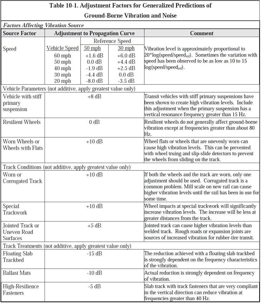
182 B2
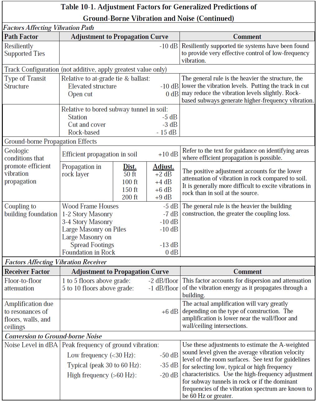
183 B3
Roadway Traffic Noise Assessment. 407 Nelson Street Ottawa, Ontario
 407 Nelson Street Ottawa, Ontario REPORT: GWE17-042 Traffic Noise Prepared For: Tony Kazarian AK Global Management Inc. 680 Eagleson Road Ottawa, Ontario K2M 2G9 Canada Prepared By: Omar Daher, B.Eng.,
Transportation Noise Assessment. 560 Rideau Street. Ottawa, Ontario
 Transportation Noise Assessment 560 Rideau Street Ottawa, Ontario REPORT: GWE13-034 Transportation Noise Prepared For: Kevin Yemm Richcraft Group of Companies 2280 St. Laurent Boulevard, Suite 201 Ottawa,
Transportation Noise Assessment. 590 Rideau Street. Ottawa, Ontario
 Transportation Noise Assessment 590 Rideau Street Ottawa, Ontario REPORT: GWE16-019 Transportation Noise Prepared For: Kevin Yemm Richcraft Group of Companies 2280 St. Laurent Boulevard, Suite 201 Ottawa,
Feasibility Noise Assessment. Westgate Shopping Centre Redevelopment. Ottawa, Ontario
 Feasibility Noise Assessment Westgate Shopping Centre Redevelopment Ottawa, Ontario REPORT: GWE15-067 - Feasibility Noise Prepared For: Stuart Craig 2300 Yonge Street, Suite 500 Toronto, Ontario M4P 1E4
Roadway Traffic Noise Feasibility Assessment. 315 Chapel Street. Ottawa, Ontario
 Roadway Traffic Noise Feasibility Assessment 315 Chapel Street Ottawa, Ontario REPORT: GWE17-002 - Traffic Noise Prepared For: Leanne Moussa Allsaints 10 Blackburn Avenue K1N 6P8 Ottawa, Ontario Prepared
Transportation Noise Assessment. 121 Parkdale Avenue. Ottawa, Ontario
 Transportation Noise Assessment 121 Parkdale Avenue Ottawa, Ontario REPORT: GWE 14-010 - Traffic Noise Prepared For: Michel Gagnon 98 Rue Lois Gatineau, Québec J8Y 3R7 Prepared By: Thomas Couper, B.A.Sc.,
Transportation Noise Assessment. 809 Richmond Road. Ottawa, Ontario
 Transportation Noise Assessment 809 Richmond Road Ottawa, Ontario REPORT: GWE16-024 - Transportation Noise Prepared For: Walter Boyce OCEF Corp 200-368 Slater Street Ottawa, Ontario K1R 5C1 Prepared By:
Traffic Noise Impact Study. 383 Slater Street / 400 Albert Street. Ottawa, Ontario
 383 Slater Street / 400 Albert Street Ottawa, Ontario REPORT: GWE16-104 - Prepared For: Anand Aggarwal 2507701 Ontario Inc. Manor Park Management 231 Brittany Drive, Suite D Ottawa, Ontario K1K 0R8 Prepared
Transportation Noise & Vibration Feasibility Assessment. 383 Albert Street & 340 Queen Street Ottawa, Ontario
 383 Albert Street & 340 Queen Street Ottawa, Ontario REPORT: GWE18-111 Noise & Vibration Prepared For: Neil Malhotra Claridge Homes 2001-210 Gladstone Avenue Ottawa, ON K2P 0Y6 Prepared By: Michael Lafortune,
Transportation Noise Assessment. 370 Queen Elizabeth Drive. Ottawa, Ontario
 Transportation Noise Assessment 370 Queen Elizabeth Drive Ottawa, Ontario REPORT: GWE14-121 - Traffic Noise REV 1 Prepared For: 2253664 Ontario Inc. Roberto Campagna 24 George Street West Ottawa, Ontario
Transportation Noise Assessment Prince of Wales Residential Development Ottawa, Ontario
 Transportation Noise Assessment 1003 Prince of Wales Residential Development Ottawa, Ontario REPORT: GWE13-031 - Traffic Noise Prepared For: Kent Bugatsch Inc. 63 Pamilla Street Ottawa, Ontario K1S 3K7
Roadway Traffic Noise Feasibility Assessment. Conservancy Subdivision. Ottawa, Ontario
 Conservancy Subdivision Ottawa, Ontario REPORT: GWE17 151 Traffic Noise Prepared For: Andrew Finnson Barrhaven Conservancy East Inc. Ottawa, Ontario Prepared By: Joshua Foster, P.Eng., Principal Omar Daher,
Roadway Traffic Noise Feasibility Assessment. Conservancy Subdivision. Ottawa, Ontario
 Conservancy Subdivision Ottawa, Ontario REPORT: GWE17 151 Traffic Noise Prepared For: Andrew Finnson Barrhaven Conservancy East Inc. Ottawa, Ontario Prepared By: Joshua Foster, P.Eng., Principal Omar Daher,
Environmental Noise Assessment. St-Charles Market. Ottawa, Ontario
 Environmental Noise Assessment St-Charles Market Ottawa, Ontario REPORT: GWE15-120 - Noise Prepared For: Jenna Maw LineBox Studio Inc. 126 York Street, Suite 502 Ottawa, Ontario K1N 5T2 Prepared By: Michael
Transportation Noise Feasibility Assessment & 3930 Riverside Drive Ottawa, Ontario
 Transportation Noise Feasibility Assessment 3960 & 3930 Riverside Drive Ottawa, Ontario REPORT: GWE18 039 Transportation Noise Prepared For: Alex Turner 225 Metcalfe Street, Suite 708 Ottawa, Ontario K2P
Environmental Noise and Vibration Assessments Place D Orleans Drive. Ottawa, Ontario
 s 1220-1226 Place D Orleans Drive Ottawa, Ontario REPORT: GWE17-154 Noise & Vibration Prepared For: Choice Properties REIT 22 St. Clair Avenue East, Suite 500 Toronto, ON M4T 2S5 c/o Pamela Whyte Parsons
3443 INNES ROAD NOISE IMPACT ASSESSMENT REPORT
 3443 INNES ROAD NOISE IMPACT ASSESSMENT REPORT Prepared By: NOVATECH Suite 200, 240 Michael Cowpland Drive Kanata, Ontario K2M 1P6 December 2017 Novatech File No. 117077 Ref No.: R-2017-192 December 19,
Noise Feasibility Study Proposed Residential Development (Infill) 747 Liverpool Road Pickering, Ontario
 747 Liverpool Road Pickering, Ontario") Noise Feasibility Study Proposed Residential Development (Infill) 747 Liverpool Road Pickering, Ontario Prepared for: Madison Liverpool Limited 369 Rimrock Road Toronto, Ontario, M3J 3G2 Prepared by Victor
Noise Feasibility Study Proposed Residential Development (Infill) 747 Liverpool Road Pickering, Ontario Prepared for: Madison Liverpool Limited 369 Rimrock Road Toronto, Ontario, M3J 3G2 Prepared by Victor
patersongroup Environmental Noise Control Study Proposed Multi-Storey Building 1088 Maritime Way - Ottawa Prepared For
 Geotechnical Engineering patersongroup Environmental Engineering Hydrogeology Geological Engineering Materials Testing Building Science Archaeological Services Environmental Noise Control Study Proposed
Transportation Noise Assessment. Salvation Army Multi Purpose Building 102 Bill Leathem Drive. Ottawa, Ontario
 Transportation Noise Assessment Salvation Army Multi Purpose Building 102 Bill Leathem Drive Ottawa, Ontario REPORT: GWE15-009 - Transportation Noise Prepared For: Michaela Jones The Salvation Army 2 Overlea
NOISE IMPACT ASSESSMENT 114 ISABELLA STREET RESIDENTIAL DEVELOPMENT OTTAWA, ONTARIO
 Smart Property Advisors Ltd. 802-500 Laurier Avenue West Ottawa, ON NOISE IMPACT ASSESSMENT 114 ISABELLA STREET RESIDENTIAL DEVELOPMENT OTTAWA, ONTARIO Prepared by: SMART PROPERTY ADVISORS LTD. 802 500
115 ECHO DRIVE CITY OF OTTAWA DETAILED NOISE STUDY
 Dix B 115 ECHO DRIVE CITY OF OTTAWA DETAILED NOISE STUDY Prepared for: UNIFORM URBAN DEVELOPMENTS Suite 300, 117 Centrepointe Drive Ottawa, Ontario K2G 5X3 Prepared by: NOVATECH Suite 200, 240 Michael
patersongroup Environmental Noise Control Study Proposed Multi-Storey Building 1136 Martime Way - Ottawa Prepared For
 Geotechnical Engineering patersongroup Environmental Engineering Hydrogeology Geological Engineering Materials Testing Building Science Archaeological Services Environmental Noise Control Study Proposed
HABITAT FOR HUMANITY 2129 Nantes Street Detailed Noise Study
 HABITAT FOR HUMANITY 2129 Nantes Street Detailed Noise Study HABITAT FOR HUMANITY 2129 Nantes Street DETAILED NOISE STUDY Prepared by: NOVATECH ENGINEERING CONSULTANTS LTD. 240 Michael Cowpland Drive,
Transportation Noise Assessment. Salvation Army Multi Purpose Building 102 Bill Leathem Drive. Ottawa, Ontario
 Transportation Noise Assessment Salvation Army Multi Purpose Building 102 Bill Leathem Drive Ottawa, Ontario REPORT: GWE15-009 - Transportation Noise R2 Prepared For: Michaela Jones The Salvation Army
J. E. COULTER ASSOCIATES LIMITED -ii- APPENDIX B: GUIDELINES
 J. E. COULTER ASSOCIATES LIMITED -ii- APPENDIX B: GUIDELINES NPC-115 NPC-115 Construction Equipment 1. Scope This Publication sets sound emission standards for various items of new construction
REP Taggart 1140 Wellington Noise Control Study Page 1 of 18
 REP Taggart 1140 Wellington Noise Control Study Page 1 of 18 2013-10-15 Simon Taggart Project Coordinator The Taggart Group 3187 Albion Road South Ottawa, Ontario K1V 8Y3 T: 613.526.2400 ext 320 C: 613.857.0353
Transportation Noise Assessment. Salvation Army Multi-Purpose Building 102 Bill Leathem Drive. Ottawa, Ontario
 Transportation Noise Assessment Salvation Army Multi-Purpose Building 102 Bill Leathem Drive Ottawa, Ontario REPORT: GWE15-009 - Transportation Noise R3 Prepared For: Michaela Jones The Salvation Army
DETAILED NOISE CONTROL STUDY PROPOSED TOWNHOUSE AND APARTMENT BUILDINGS BRONTE ROAD DEVELOPMENT TOWN OF OAKVILLE
 SS WILSON ASSOCIATES Consulting Engineers REPORT NO. WA10-93 REVISION 3 DETAILED NOISE CONTROL STUDY PROPOSED TOWNHOUSE AND APARTMENT BUILDINGS BRONTE ROAD DEVELOPMENT TOWN OF OAKVILLE SUBMITTED TO: BALLANTRY
1 INTRODUCTION 4 2 NOISE DESCRIPTORS 5 3 NOISE SENSITIVE POINTS OF RECEPTION 5 4 PROPOSED LAND USE 7 5 GUIDELINES AND CRITERIA 8
 Durham Live Tourist Destination Page 2 of 24 29 May 2014 1 INTRODUCTION 4 2 NOISE DESCRIPTORS 5 3 NOISE SENSITIVE POINTS OF RECEPTION 5 4 PROPOSED LAND USE 7 5 GUIDELINES AND CRITERIA 8 5.1 ROAD & RAIL
Yorkdale Development Master Plan Environmental Noise and Vibration Feasibility Study Toronto, ON
 ASSESSMENT REPORT - Project: 16419 Yorkdale Development Master Plan Environmental Noise and Vibration Feasibility Study Toronto, ON Prepared for: Oxford Properties Group Royal Bank Plaza North Tower 200
Appendix C STAMSON Noise Model Output File for Tunnel Alternative (Alternative 3)
") Appendix C STAMSON Noise Model Output File for Tunnel Alternative (Alternative 3) Detroit River International Crossing Study STAMSON 5.0 NORMAL REPORT Date: 21-02-2007 01:14:41 MINISTRY OF ENVIRONMENT
Appendix C STAMSON Noise Model Output File for Tunnel Alternative (Alternative 3) Detroit River International Crossing Study STAMSON 5.0 NORMAL REPORT Date: 21-02-2007 01:14:41 MINISTRY OF ENVIRONMENT
MAY 5, Noise Barrier Presentation SE Quadrant Noyes Street and Lincoln Street NOISE BARRIER ABUTTER MEETING. Tech Environmental, Inc.
 MAY 5, 2011 Noise Barrier Presentation SE Quadrant Noyes Street and Lincoln Street Jacobs Engineering Group Group Inc. Inc. 1 Introductions Agenda Overview of Interchange Project Overview of noise barrier
Appendix G Noise Modeling Files
 Appendix G Noise Modeling Files County of Butte Rio d Oro Specific Plan Noise Study July 2014 Rio d Oro Specific Plan Noise Study Prepared for: JKB Development 2370 West Monte Vista Ave. Turlock, CA 95381
Noise Maps, Report & Statistics, Dublin City Council Noise Mapping Project Roads and Traffic Department
 Noise Maps, Report & Statistics, Dublin City Council Noise Mapping Project Roads and Traffic Department Produced by Traffic Noise & Air Quality Unit November 2007 Contact: brian.mcmanus@dublincity.ie Ph;
Dubai Municipality LRT Noise and Vibration Impact Stage 2
 Dubai Municipality LRT Noise and Vibration Impact Stage 2 Environmental Impact 11 th of April, 2004 Environmental Impact Report According to the PS007 Agreement, Environmental Impact Report Based on Noise
Directive on the Assessment and Management of Environmental Noise
 Directive on the Assessment and Management of Environmental Noise This Directive has been ratified by the European Parliament and is awaiting publication in the Official Journal.( around 23/5/02) The Directive
GIS-BASED VISUALISATION OF TRAFFIC NOISE
 Proceedings of the 9 th International Conference on Environmental Science and Technology Rhodes island, Greece, 1 3 September 2005 GIS-BASED VISUALISATION OF TRAFFIC NOISE A. KONSTANTINIDIS 1, K. EVANGELIDIS
Noise from Oil & Gas Facilities Acoustics 101 and Best Practices for Noise Control. Rob Stevens, HGC Engineering
 Noise from Oil & Gas Facilities Acoustics 101 and Best Practices for Noise Control Rob Stevens, HGC Engineering Noise From Oil & Gas Facilities Acoustics 101 and Best Practices for Noise Control Rob Stevens
APPENDIXD. Traffic Noise Technical Report
 APPENDIXD Traffic Noise Technical Report Environmental Assessment - Lincoln County, SD 85 th Street: Sundowner Avenue to Louise Avenue November 2017 F I N A L R E P O R T TRAFFIC NOISE TECHNICAL REPORT
MINISTRY OF TRANSPORTATION HIGHWAY 404 EXTENSION FINAL NOISE STUDY. Assignment Number: 2013-E-0017 #3
 MINISTRY OF TRANSPORTATION HIGHWAY 404 EXTENSION FINAL NOISE STUDY Assignment Number: 2013-E-0017 #3 Submitted to: The Ministry of Transportation 1201 Wilson Avenue Downsview, Ontario M3M 1J8 Submitted
Answer - SAQ 1. The intensity, I, is given by: Back
 Answer - SAQ 1 The intensity, I, is given by: Noise Control. Edited by Shahram Taherzadeh. 2014 The Open University. Published 2014 by John Wiley & Sons Ltd. 142 Answer - SAQ 2 It shows that the human
ENVIRONMENTAL NOISE IMPACT ASSESSMENT
 REPORT REFERENCE: SA 4968 rev 1 ENVIRONMENTAL NOISE IMPACT ASSESSMENT British Standard 8233: 2014. CLIENT: MJ Gleeson SITE: Berengrave Nursery, 61 Berengrave Road, Rainham, Kent, ME 7NL SURVEY DATES: Noise
Assessment & Specifications for Noise Controls
 Project 772600 Rev 1 Cargill North Vancouver Grain Terminal Assessment & Specifications for Noise Controls TABLE OF CONTENTS 1. INTRODUCTION...1 1.1 Background...1 1.2 Site Description...1 2. SOUND LEVEL
1 Wind Turbine Acoustics. Wind turbines generate sound by both mechanical and aerodynamic
 Wind Turbine Acoustics 1 1 Wind Turbine Acoustics Wind turbines generate sound by both mechanical and aerodynamic sources. Sound remains an important criterion used in the siting of wind farms. Sound emission
Pedestrian Level Wind Study. West Village 70 Mississauga Road South & 181 Lakeshore Road West. Mississauga, Ontario
 Pedestrian Level Wind Study West Village 70 Mississauga Road South & 181 Lakeshore Road West Mississauga, Ontario REPORT: GWE17-112-PLW Prepared For: c/o Emily Rosen Diamondcorp 22 St. Clair Avenue East,
Appendix E FTA NOISE MODELING WORKSHEETS AND DETAILED METHODOLOGY
 Appendix E FTA NOISE MODELING WORKSHEETS AND DETAILED METHODOLOGY APPENDIX E General Noise Assessment The FTA General Noise Assessment procedure was used for calculating noise from transit sources associated
APPENDIX IV MODELLING
 APPENDIX IV MODELLING Kingston Transportation Master Plan Final Report, July 2004 Appendix IV: Modelling i TABLE OF CONTENTS Page 1.0 INTRODUCTION... 1 2.0 OBJECTIVE... 1 3.0 URBAN TRANSPORTATION MODELLING
COULD THE GUNSHOT BE HEARD?
 COULD THE GUNSHOT BE HEARD? October 9, 2003 Paul D. Schomer Schomer & Associates Champaign, IL 61821 INTRODUCTION Statement of Problem On the evening of November 21, 1991, a NJ State Trooper gave chase
Fundamentals of Sound
 Sound is an important consideration in the selection of mechanical equipment. The purpose of this article is to present a procedure for evaluating the sound levels created by evaporative cooling equipment
APPENDIX B. Noise Primer
 APPENDIX B Noise Primer NOISE PRIMER TABLE OF CONTENTS 1. INTRODUCTION...1 2. BASIC SOUND PRINCIPLES...1 2.1. SOUND AS A WAVE...1 2.2. SOUND PRESSURE LEVEL...2 2.2.1. Decibel Math...4 2.2.2. Descriptive
Paine Field Airport Existing and Future Environmental Assessment, Initiation of Commercial Service Noise Analysis
 Paine Field Airport Existing and Future Environmental Assessment, Initiation of Commercial Service Noise Analysis July 2012 Prepared by: BridgeNet International 3151 Airway Avenue Building I-2 Costa Mesa,
Chapter 11. Noise Impacts of Transportation Systems. Transportation Decision-making Principles of Project Evaluation and Programming
 Transportation Decision-making Principles of Project Evaluation and Programming Chapter 11 Noise Impacts of Transportation Systems Kumares Sinha and Samuel Labi 1 2 Real Experiences of Transportation Noise
WEST VALLEY BOULEVARD MIXED USE PROJECT NOISE IMPACT ANALYSIS. January 9, 2015
 400-420 WEST VALLEY BOULEVARD MIXED USE PROJECT NOISE IMPACT ANALYSIS January 9, 2015 Kunzman Associates, Inc. 400-420 WEST VALLEY BOULEVARD MIXED USE PROJECT NOISE IMPACT ANALYSIS January 9, 2015 Prepared
CERTIFIED RESOLUTION. introduction: and dated May 29, 2017, as attached, as appropriate
 15322 Buena Vista Avenue, White Rock BC, Canada V4B 1Y6 www.whiterockcity.ca City of White Rock P: 604.541.22121 F: 604.541.9348 /2tC% City Clerk s Office IT E ROC K June 13,2017 Stephanie Lam, Deputy
Appendixx C Travel Demand Model Development and Forecasting Lubbock Outer Route Study June 2014
 Appendix C Travel Demand Model Development and Forecasting Lubbock Outer Route Study June 2014 CONTENTS List of Figures-... 3 List of Tables... 4 Introduction... 1 Application of the Lubbock Travel Demand
Acoustic spaces: comfort and social sustainability
 European congress Eco-Technologies for the future 9 June 2010 Acoustic materials and spaces for sustainability Professor Jian Kang School of Architecture, University of Sheffield, UK Outline Acoustics
Published in: Proceeding of 9th SENVAR / 2nd ISESEE, Shah Alam, Malaysia, December 2008
 Evaluation on Lighting Condition and Visual Legibility of Road Surfaces and Traffic Signs in Bandung City Mangkuto, R.A.; Soelami, F.X.N.; Soegijanto, R.M. Published in: Proceeding of 9th SENVAR / 2nd
APPENDIX Q BLASTING IMPACT ASSESSMENT REPORT
 APPENDIX Q BLASTING IMPACT ASSESSMENT REPORT BLASTING IMPACT ASSESSMENT: FUTURE BLASTING OPERATIONS AT THE MOOSE RIVER OPEN PIT GOLD MINE DEVELOPMENT SITE TOUQUOY GOLD PROJECT MOOSE RIVER, HALIFAX COUNTY,
1600 Prairie Drive , FAX
 Hennepin County Transportation Department Transportation Department 612-596-0300, Phone 1600 Prairie Drive 612-321-3410, FAX Medina, MN 55340-5421 www.hennepin.us December 30, 2015 Subject: Bottineau Boulevard
research highlight Wind-Rain Relationships in Southwestern British Columbia Introduction Methodology Figure 2 Lower Mainland meteorological stations
 research highlight June 2007 Technical Series 07-114 Introduction Building envelope failures in southwestern British Columbia has brought to light the strong influence of wind-driven rain on building envelopes.
WEBER ROAD RESIDENTIAL DEVELOPMENT Single Family Residential Project
 WEBER ROAD RESIDENTIAL DEVELOPMENT Single Family Residential Project WEBER ROAD RESIDENTIAL DEVELOPMENT TRAFFIC IMPACT STUDY TABLE OF CONTENTS 1.0 Executive Summary Page 2.0 Introduction 2.1 DEVELOPMENT
MEMORANDUM. The study area of the analysis was discussed with City staff and includes the following intersections:
 MEMORANDUM DATE: JULY 6, 2012 TO: FROM: RE: CC: MELANIE KNIGHT BRAD BYVELDS/ JENNIFER LUONG 1050 SOMERSET STREET PRELIMINARY TRAFFIC ANALYSIS OUR FILE NO. 111152 NEIL MALHOTRA The purpose of this memo
JEP John E. Jack Pflum, P.E. Consulting Engineering 7541 Hosbrook Road, Cincinnati, OH Telephone:
 JEP John E. Jack Pflum, P.E. Consulting Engineering 7541 Hosbrook Road, Cincinnati, OH 45243 Email: jackpflum1@gmail.com Telephone: 513.919.7814 MEMORANDUM REPORT Traffic Impact Analysis Proposed Soccer
Appendix 2. Extracts from Ministry for the Environment Active Fault Guidelines 2003
 Extracts from Ministry for the Environment Active Fault Guidelines 2003 Published in July 2003 by the Ministry for the Environment Manatu Mo Te Taiao PO Box 10-362, Wellington, New Zealand ISBN: 0-478-18901
STAFF REPORT ACTION REQUIRED. Extreme Cold Weather Alerts in Toronto SUMMARY. Date: April 13, Board of Health. To: Medical Officer of Health
 HL3.6 STAFF REPORT ACTION REQUIRED Extreme Cold Weather Alerts in Toronto Date: April 13, 2015 To: From: Wards: Board of Health Medical Officer of Health All Reference Number: SUMMARY Cold weather can
Regal House #CREATESOMETHING. ALL ENQUIRIES 53,647 sq.ft. RE-DEVELOPMENT OPPORTUNITY SUITABLE FOR A VARIETY OF USES OFFICE HOTEL RESIDENTIAL
 SK1 3AA #CREATESOMETHING RE-DEVELOPMENT OPPORTUNITY OFFICE HOTEL RESIDENTIAL Stockport has everything Excellent motorway access First class rail links Efficient local bus services Easy access to Manchester
PW 001 SNOW REMOVAL AND SANDING FOR ROADWAYS AND SIDEWALKS October 6, 2014 (#223-14) Original October 19, 2015; October 15, 2018 Public Works
 Original October 19, 2015; October 15, 2018 Public Works") Policy Statement: The Village of Kitscoty will provide snow and ice control on municipal streets and sidewalks according to determined priorities. Purpose: To provide direction and information to employees
Policy Statement: The Village of Kitscoty will provide snow and ice control on municipal streets and sidewalks according to determined priorities. Purpose: To provide direction and information to employees
FINAL REPORT. On Project Supplemental Guidance on the Application of FHWA s Traffic Noise Model (TNM) APPENDIX J Wind and Temperature Gradients
 APPENDIX J Wind and Temperature Gradients") FINAL REPORT On Project 25-34 Supplemental Guidance on the Application of FHWA s Traffic Noise Model (TNM) APPENDIX J Wind and Temperature Gradients Prepared for: National Cooperative Highway Research
FINAL REPORT On Project 25-34 Supplemental Guidance on the Application of FHWA s Traffic Noise Model (TNM) APPENDIX J Wind and Temperature Gradients Prepared for: National Cooperative Highway Research
Effect of Environmental Factors on Free-Flow Speed
 Effect of Environmental Factors on Free-Flow Speed MICHAEL KYTE ZAHER KHATIB University of Idaho, USA PATRICK SHANNON Boise State University, USA FRED KITCHENER Meyer Mohaddes Associates, USA ABSTRACT
STAFF REPORT ACTION REQUIRED
 STAFF REPORT ACTION REQUIRED Appeal by Fast Signs of the Decision of the Chief Building Official for One Variance Respecting a Proposed First Party Wall Sign 10-21 Four Seasons Place Date: January 18,
LIST OF PUBLISHED STANDARDS
 Report : 08-06- Page o : Of 9 LST OF PUBLSHED STDRDS Total Count: 9 umber SS umber nt pproved mendment SBS/TC 076 SS 40-:997/SO 40-:997 coustics - Measurement of sound insulation in buildings and of building
EVALUATION OF NOISE LEVELS PRODUCED BY OP- ERATION AND MAINTENANCE ACTIVITIES OF A CON- TINUOUS MOVEMENT FUNICULAR
 EVALUATION OF NOISE LEVELS PRODUCED BY OP- ERATION AND MAINTENANCE ACTIVITIES OF A CON- TINUOUS MOVEMENT FUNICULAR Andrea Nicolini, Mirko Filipponi University of Perugia, via G. Duranti 67, 06125 Perugia,
Special edition paper
 Study on Conventional Railway Line in High Spaces Satoshi Ishikawa* Ryo Shiraga* Kenichi Yaginuma* Toru Masuda* In this study, we carried out noise measurement in different environments including high
COUNCIL POLICY MANUAL
 COUNCIL POLICY MANUAL SECTION: PUBLIC WORKS SUBJECT: SNOW & ICE CONTROL POLICY 2012/2013 GOAL: Pages: 1 of 10 Approval Date: Dec. 3, 2012 Res. # 1001/2012 To annually identify the winter maintenance costs
Zoning Ordinance. Requirements Used Districts R1 R2 R2.6 R3 R4 R5 B1 B2 B3 B4 M1 M2 RH Density Low Low Med Med High High Gen Local CBD Local LT Hvy Ag
 The ordinance shall be known as the Zoning Ordinance of Wetumpka, Alabama, and the map herein referred to as the Zoning Map of Wetumpka, Alabama. The map and all explanatory matter thereon are hereby adopted
FIRST, MORE ABOUT SOUND
 FIRST, MORE ABOUT SOUND www.fullbhuna.co.uk/images/ www.privateline.com/telephonehistory/ ways of describing sound in architectural acoustics Ball State Architecture ENVIRONMENTAL SYSTEMS 1 Grondzik 1
HURRICANE MARIA PUERTO RICO ASSESSMENT FOUR & SIX MONTHS POST LANDFALL. January & March 2018
 HURRICANE MARIA PUERTO RICO ASSESSMENT FOUR & SIX MONTHS POST LANDFALL January & March 2018 CONCLUSIONS OF FIELD RECON JANUARY AND MARCH 2018 JLT Re conducted an island wide damage survey four month after
NOISE PREDICTION, CALCULATION AND MAPPING USING SPECIALIZED SOFTWARE
 Journal of Engineering Studies and Research Volume 21 (2015) No. 3 59 NOISE PREDICTION, CALCULATION AND MAPPING USING SPECIALIZED SOFTWARE ALINA PETROVICI 1, CLAUDIA TOMOZEI 1, RICARDO GEY FLORES 2, FLORIN
High Speed / Commuter Rail Suitability Analysis For Central And Southern Arizona
 High Speed / Commuter Rail Suitability Analysis For Central And Southern Arizona Item Type Reports (Electronic) Authors Deveney, Matthew R. Publisher The University of Arizona. Rights Copyright is held
Subject: Desert Palisades Specific Plan - Tram Way Access Sight Distance
 Endo Engineering Traffic Engineering Air Quality Studies Noise Assessments July 13, 2015 Mr. Ed Freeman Pinnacle View, LLC P.O. Box 1754 Lake Oswego, OR 97035-0579 Subject: Desert Palisades Specific Plan
III. FORECASTED GROWTH
 III. FORECASTED GROWTH In order to properly identify potential improvement projects that will be required for the transportation system in Milliken, it is important to first understand the nature and volume
October 16, Dear Mr. Hawkins:
 IBI GROUP 101 410 Albert Street Waterloo ON N2L 3V3 Canada tel 519 585 2255 fax 519 585 2269 October 16, 2017 Mr. Trevor Hawkins Manager of Applications and Implementation Integrated Planning and Public
April 10, Mr. Curt Van De Walle, City Manager City of Castle Hills 209 Lemonwood Drive Castle Hills, Texas 78213
 Mr. Curt Van De Walle, City Manager City of Castle Hills 209 Lemonwood Drive Castle Hills, Texas 78213 Subject: Revised Castle Hills BASIS Charter School Traffic Impact Analysis Review City of Castle Hills,
SUSTAINABLE BUILT ENVIRONMENT - Vol. I Acoustics in the Built Environment - Richard Guy
 ACOUSTICS IN THE BUILT ENVIRONMENT Richard Guy Department of Building, Civil and Environmental Engineering, Concordia University, Montreal, Quebec H3G M8, Canada Keywords: Sound; Community Noise; Road,
SHADOW STUDY REPORT REGARDING
 SHADOW STUDY REPORT REGARDING an APPLICATION TO REDEVELOP Three 6 Storey Condominiums Regional Road 25 (Ontario Street) and Britannia Road Milton, Ontario KNYMH FILE # 17030 Prepared by: Krista Lilley
Re: Draft OPA 320 Recommended Amendments to Various Neighbourhood Policies Statutory Public Meeting to be held on Monday 16 November 2015
 PG8.5.5 ANALOGICA George S. Belza Partner 9 Madeline Road Toronto, Ontario Canada M2N 2S7 T: 416 223 9584 F: 416 223 5665 E: belana@axxent.ca E-Mailed to: pgmc@toronto.ca Wednesday 04 November 2015 Planning
ISO INTERNATIONAL STANDARD
 INTERNATIONAL STANDARD ISO 140-6 Second edition 1998-08-15 Acoustics Measurement of sound insulation in buildings and of building elements Part 6: Laboratory measurements of impact sound insulation of
 Material sobre SOM e db Fonte: http://www.engineeringtoolbox.com/decibel27_59.html Sound Pressure The Sound Pressure is the force of sound on a surface area perpendicular to the direction of the sound.
Neighborhood Locations and Amenities
 University of Maryland School of Architecture, Planning and Preservation Fall, 2014 Neighborhood Locations and Amenities Authors: Cole Greene Jacob Johnson Maha Tariq Under the Supervision of: Dr. Chao
Building Envelope Requirements Overview Page 3-4
 Building Envelope Requirements Overview Page 3-4 The benefit of a high reflectance surface is obvious: while dark surfaces absorb the sun s energy (visible light, invisible infrared. and ultraviolet radiation)
Traffic Impact Study
 Traffic Impact Study Statham DRI One University Parkway Prepared for: Barrow County Prepared by: October 2012 Table of Contents Executive Summary i Section 1. Introduction 1 Project Description 1 Methodology
KEY: R-1 Low Density Residential. R-2 Medium Density Residential. R-3 High Density Residential. S-C Service Commercial. D-C Downtown Commercial
 KEY: R-1 Low Density Residential R-2 Medium Density Residential R-3 High Density Residential S-C Service Commercial D-C Downtown Commercial M-C Medical Commercial H-I Heavy Industrial PARKING MATRIX A
Appendix N Noise Study
 Appendix N Noise Study NOTICE The information contained in this Appendix was developed strictly for the purpose of evaluating the environmental impacts associated with the Ambassador Bridge Enhancement
Turbines and turbine sets Measurement of emitted airborne noise Engineering/survey method
 INTERNATIONAL STANDARD ISO 10494 Second edition 2018-04 Turbines and turbine sets Measurement of emitted airborne noise Engineering/survey method Turbines et groupes de turbines Mesurage du bruit aérien
Date: March 31, 2014 PATE; fyril 2.3,2 >H
 aj BRAMPTON fifs Rower City XH-l-f r.t "»* City Council The Corporation of the City of Brampton SRAMPTON CITY COUNCIL Date: March 31, 2014 PATE; fyril 2.3,2 >H File: POO GR VisWhtoJed ^t'th-meeh'^a Subject:
APPENDIX 11A: BASELINE NOISE MONITORING RESULTS
 appendix 11a APPENDIX 11A: BASELINE NOISE MONITORING RESULTS Table 11.A.1: Summary of daytime noise measurements Location Time Measured Noise Levels (db re. 2x10⁻⁵ Pa) LAeq LA10 LA90 12:59 13:14 64 67
East Bay BRT. Planning for Bus Rapid Transit
 East Bay BRT Planning for Bus Rapid Transit Regional Vision Draper Prison The Bottleneck is a State-Level issue, Salt Lake County 2050 Population: 1.5M Draper Prison hopefully with some State-Level funding!
SHADOW IMPACT STUDY REPORT
 SHADOW IMPACT STUDY REPORT 175 Zoo Park Road Town of Wasaga Beach Date: September 2017 Prepared for: Simcoe County Housing Corporation Prepared by: MacNaughton Hermsen Britton Clarkson Planning Limited
City of Hermosa Beach Beach Access and Parking Study. Submitted by. 600 Wilshire Blvd., Suite 1050 Los Angeles, CA
 City of Hermosa Beach Beach Access and Parking Study Submitted by 600 Wilshire Blvd., Suite 1050 Los Angeles, CA 90017 213.261.3050 January 2015 TABLE OF CONTENTS Introduction to the Beach Access and Parking