Transportation Noise & Vibration Feasibility Assessment. 383 Albert Street & 340 Queen Street Ottawa, Ontario
|
|
|
- Dustin Wilkins
- 5 years ago
- Views:
Transcription
 836-0934 www.gradientwind.")
1 383 Albert Street & 340 Queen Street Ottawa, Ontario REPORT: GWE Noise & Vibration Prepared For: Neil Malhotra Claridge Homes Gladstone Avenue Ottawa, ON K2P 0Y6 Prepared By: Michael Lafortune, C.E.T., Environmental Scientist Joshua Foster, P.Eng., Principal August 7, Walgreen Road, Ottawa, Ontario, Canada K0A 1L0 (613)
2 EXECUTIVE SUMMARY This document describes a transportation noise and vibration feasibility assessment performed for a proposed mixed-use development located at 383 Albert Street & 340 Queen Street in Ottawa, Ontario. The proposed development comprises three building components, referred to as Tower A Condo (26 storeys), Tower B Hotel (9 storeys), and Tower C Rental (26 storeys), which are connected by an L - shaped 2-storey podium. Towers A, B, and C are situated clockwise beginning at the northeast corner of the site, respectively. Retail space is located at grade with hotel and residential amenity space and suites located on the remaining floors. Outdoor amenity space is provided atop the common podium, as well a atop Tower B as common terraces. The Confederation Line LRT will run underground along Queen street, just north of the site, which is a source of ground vibration. Major sources of transportation noise include roadway traffic along Lyon Street and Albert Street. Figure 1 illustrates a complete site plan with surrounding context. The assessment is based on: (i) theoretical noise prediction methods that conform to the Ministry of the Environment, Conservation and Parks (MOECP) and City of Ottawa requirements; (ii) noise level criteria as specified by the City of Ottawa s Environmental Noise Control Guidelines (ENCG); and (iii) architectural drawings received from Neuf Architects, dated July 13, The results of the current analysis indicate that noise levels will range between 39 and 70 dba during the daytime period (07:00-23:00) and between 31 and 63 dba during the nighttime period (23:00-07:00). The highest noise levels (i.e. 70 dba) occur near the corner of Lyon Street and Albert Street. The noise levels predicted due to roadway and LRT traffic exceed the criteria listed in Section 4.2 for building components. Upgraded building components, including STC rated glazing elements and exterior walls, will be required where noise levels exceed 65 dba, as discussed in Section Results of the calculations also indicate that the development will require air conditioning, which will allow occupants to keep windows closed and maintain a comfortable living environment. In addition to ventilation requirements, Warning Clauses will also be required be placed on all Lease, Purchase and Sale Agreements. Specific noise control measures can be developed once the design of the building has progressed sufficiently, these are typically identified at the time of site plan control. i
3 With regards to stationary noise impacts from roof top mechanical units, generators and other stationary sources associated with the development, on the proposed building and on surrounding noise-sensitive areas, once the mechanical plans for the proposed building become available, a stationary noise study will be performed. This study will include recommendations for any noise control measures that may be necessary to ensure noise levels at the proposed building and noise levels at the surrounding noisesensitive buildings are below the City of Ottawa s Noise Guidelines. For this development potential equipment includes generators, roof top air-handling equipment, cooling towers or dry coolers, as well as refrigeration equipment for a possible grocery store tenant, located on the podium roof. Noise control for these units can be achieved by placing units away from noise-sensitive windows, judicious selection of quieter units, and introduction of silencers and noise screens. Estimated vibration levels at the nearest property line to the LRT corridor are expected to be 0.06 mm/s RMS (67 dbv), based on the FTA protocol and a conservative offset distance of 13 m to the nearest track centerline. Details of the calculation are provided in Appendix B. Since predicted vibration levels do not exceed the criterion of 0.1 mm/s RMS at the property line, vibration mitigation would not be required. As vibration levels are acceptable, correspondingly regenerated noise levels are also expected to be acceptable. ii
4 TABLE OF CONTENTS 1. INTRODUCTION 1 2. TERMS OF REFERENCE 1 3. OBJECTIVES 2 4. METHODOLOGY Background Roadway Traffic Noise Criteria for Roadway Traffic Noise Roadway Traffic Volumes Theoretical Roadway Traffic Noise Predictions Ground Vibrations Ground Vibrations Background Ground Vibrations Criteria Theoretical Ground Vibration Predictions 6 5. RESULTS AND DISCUSSION Roadway Traffic Noise Levels Ground Vibrations & Ground-Borne Noise Levels 9 6. CONCLUSIONS AND RECOMMENDATIONS 9 FIGURES APPENDICES Appendix A STAMSON 5.04 Input and Output Data Appendix B FTA Vibration Calculations iii
5 1. INTRODUCTION Gradient Wind Engineering Inc. (GWE) was retained by Claridge Homes to undertake a transportation noise and vibration feasibility assessment for a proposed mixed-use development located at 383 Albert Street & 340 Queen Street in Ottawa, Ontario. This report summarizes the methodology, results, and recommendations related to a transportation noise and vibration feasibility assessment, prepared in support of a rezoning application. GWE s scope of work involved assessing exterior noise and vibration levels generated by local roadway and railway traffic. The assessment was performed based on theoretical noise calculation methods conforming to the City of Ottawa 1 and Ministry of the Environment and Climate Change (MOECC) 2 guidelines. Noise calculations were based on architectural drawings received from Neuf Architects, dated July 13, 2018, with future roadway traffic volumes based on the City of Ottawa s Official Plan (OP) roadway classifications. 2. TERMS OF REFERENCE The focus of this transportation noise and vibration feasibility assessment is the proposed mixed-use development located at 383 Albert Street & 340 Queen Street in Ottawa, Ontario. The study site is situated on a parcel of land bounded by Queen Street to the north, Lyon Street to the east, and Albert Street to the South. The Confederation Line LRT will run underground along Queen street, just north of the site, which is a source of ground vibration. Major sources of transportation noise include roadway traffic along Lyon Street and Albert Street. Figure 1 illustrates a site plan with surrounding context. The proposed development comprises three building components, referred to as Tower A Condo (26 storeys), Tower B Hotel (9 storeys), and Tower C Rental (26 storeys), which are connected by an L - shaped 2-storey podium. Towers A, B, and C are situated clockwise beginning at the northeast corner of the site, respectively. Retail space is located at grade with hotel and residential amenity space and suites located on the remaining floors. Outdoor amenity space is provided atop the common podium, as well a atop Tower B as common terraces. Private balconies are not considered to be noise sensitive unless they are greater than 4 metres in depth according to provincial noise guidelines. 1 City of Ottawa Environmental Noise Control Guidelines, January Ontario Ministry of the Environment and Climate Change Environmental Noise Guidelines, Publication NPC-300, Queens Printer for Ontario, Toronto,
6 3. OBJECTIVES The main goals of this work are to: (i) calculate the future noise and vibration levels on the study building produced by local roadway and railway traffic, and (ii) determine whether noise and vibration levels exceed the allowable limits specified by the MOECP Noise Control Guidelines NPC-300 as outlined in Section 4 of this report. 4. METHODOLOGY 4.1 Background Noise can be defined as any obtrusive sound. It is created at a source, transmitted through a medium, such as air, and intercepted by a receiver. Noise may be characterized in terms of the power of the source or the sound pressure at a specific distance. While the power of a source is characteristic of that particular source, the sound pressure depends on the location of the receiver and the path that the noise takes to reach the receiver. Measurement of noise is based on the decibel unit, dba, which is a logarithmic ratio referenced to a standard noise level ( Pascals). The A suffix refers to a weighting scale, which better represents how the noise is perceived by the human ear. With this scale, a doubling of power results in a 3 dba increase in measured noise levels and is just perceptible to most people. An increase of 10 dba is often perceived to be twice as loud. 4.2 Roadway Traffic Noise Criteria for Roadway Traffic Noise For vehicle traffic, the equivalent sound energy level, L eq, provides a measure of the time varying noise levels, which is well correlated with the annoyance of sound. It is defined as the continuous sound level, which has the same energy as a time varying noise level over a period of time. For roadways, the L eq is commonly calculated on the basis of a 16-hour (L eq16) daytime (07:00-23:00) / 8-hour (L eq8) nighttime (23:00-07:00) split to assess its impact on residential buildings. The NPC-300 guidelines specify that the recommended indoor noise limit range (that is relevant to this study) is 50, 45 and 40 dba for office space, residence living rooms/hotel sleeping quarters, and residence sleeping quarters respectively, as listed in Table 1. To account for deficiencies in building construction, theses levels should be targeted toward 47, 42 and 37 dba. 2
7 TABLE 1: INDOOR SOUND LEVEL CRITERIA 3 Type of Space Time Period Road L eq (dba) General offices, reception areas, retail stores, etc. 07:00 23: Living/dining/den areas of residences, hospitals, schools, nursing/retirement homes, day-care centres, theatres, places of worship, libraries, individual or semi-private offices, conference rooms, etc. Rail 07:00 23: Sleeping quarters of hotels/motels 23:00 07: Sleeping quarters of residences, hospitals, nursing/retirement homes, etc. 23:00 07: Predicted noise levels at the plane of window (POW) dictate the action required to achieve the recommended sound levels. An open window is considered to provide a 10 dba reduction in noise, while a standard closed window is capable of providing a minimum 20 dba noise reduction 4. A closed window due to a ventilation requirement will bring noise levels down to achieve an acceptable indoor environment 5. Therefore, where noise levels exceed 55 dba daytime and 50 dba nighttime, the ventilation for the building should consider the need for having windows and doors closed, which normally triggers the need for central air conditioning. Where noise levels exceed 65 dba daytime and 60 dba nighttime, building components will require higher levels of sound attenuation 6. For designated Outdoor Living Areas the sound level limit is 55 dba during the daytime period. Only in cases were the required noise control measures are not feasible for technical, economic, or administrative reasons should an excess above the limit be acceptable. 3 Adapted from Table C-2, Part C, Section of NPC Burberry, P.B. (2014). Mitchell s Environment and Services. Routledge, Page MOECC, Environmental Noise Guidelines, NPC 300 Part C, Section MOECC, Environmental Noise Guidelines, NPC 300 Part C, Section
8 4.2.2 Roadway Traffic Volumes The ENCG dictates that noise calculations should consider future sound levels based on a roadway s classification at the mature state of development. Therefore, traffic volumes are based on the roadway classifications outlined in the City of Ottawa s Official Plan (OP) and Transportation Master Plan 7 which provide additional details on future roadway expansions. Average Annual Daily Traffic (AADT) volumes are then based on data in Table B1 of the ENCG for each roadway classification. Table 2 (below) summarizes the AADT values used for each roadway included in this assessment. TABLE 2: ROADWAY TRAFFIC DATA Segment Roadway Class Speed Limit (km/h) ENCG AADT Count Lyon Street 2-UAU 50 15,000 Albert Street 2-UAU 50 15, Theoretical Roadway Traffic Noise Predictions Noise predictions were performed with the aid of the MOECC computerized noise assessment program, STAMSON 5.04, for road and rail analysis. Roadway noise calculations were performed by treating each road segment as separate line sources of noise, and by using existing building locations as noise barriers. In addition to the traffic volumes summarized in Table 2 below, theoretical noise predictions were based on the following parameters: Truck traffic on all roadways was taken to comprise 5% heavy trucks and 7% medium trucks, as per ENCG requirements for noise level predictions. Reflective intermediate ground surfaces used. Receptor heights placed at 1.5, 16, 32.5, 42.5 and 79.5 m for ground floor, 3 rd Floor, 9 th Floor, 13 th Floor and 26 th Floor respectively. Surrounding buildings used as noise barriers. The study site was treated as having flat/gently slopping topography. Noise receptors were strategically placed at 20 locations around the study area as illustrated in Figure 2. 7 City of Ottawa Transportation Master Plan, November
9 4.3 Ground Vibrations Ground Vibrations Background Rail lines and transit systems can produce perceptible levels of ground vibrations, especially when they are in close proximity to residential neighbourhoods. Similar to sound waves in air, ground vibrations are generated at a source, propagated through a medium, and intercepted by a receiver. In the case of ground vibrations, the medium can be uniform, or more often, a complex layering of soils and rock strata. Also, similar to sound waves in air, ground vibrations produce perceptible motions and regenerated noise known as ground-borne noise when the vibrations encounter a hollow structure such as a building. Ground-borne noise and vibrations are generated when there is excitation of the ground (from a train for instance). Repetitive motion of steel wheels on uneven rail cause vibrations to propagate through the soil until they encounter a building. The vibrations travel along the structure of the building, beginning at the foundation, and propagate to all floor levels. Air inside the building is also excited by the vibrating walls and floors and creates regenerated airborne noise. Characteristics of the soil and the building dictate the tone and intensity of the noise, thereby creating a noise signature that is unique to that structure and soil combination. Human response to ground vibrations is dependent on the magnitude of the vibrations, which is measured by the root mean square (RMS) of the movement of a particle on a surface. Typical units of ground vibration measures are millimetres per second (mm/s), or inches per second (in/s). The threshold level of human perception to vibrations is approximately 0.10 mm/s RMS. Although somewhat variable among humans, the threshold of annoyance for continuous vibrations is 1.0 mm/s RMS; this is ten times higher than the perception threshold. The threshold for cosmetic building damage is greater than 30 mm/s, at least three hundred times higher than the perception threshold level Ground Vibrations Criteria In the United States, the Federal Transportation Authority (FTA) has set vibration criteria for sensitive land use next to Transit corridors. Similar standards have been developed by a partnership between the 8 C.H. Dowding, Blast Vibration Monitoring & Control, Prentice Hall,
10 MOECP and the Toronto Transit Commission 9. These standards indicate that the appropriate criteria for residential buildings is 0.10 mm/s RMS for vibrations. For main line railways, a document titled Guidelines for New Development in Proximity to Railway Operations 10 indicates that vibration conditions should not exceed 0.14 mm/s RMS averaged over a one second time-period at the first floor and above of the proposed building. As the main vibration source is due to the LRT lines, which will have frequent events, the 0.10 mm/s RMS (72 dbv) vibration criteria and 35 dba ground borne noise criteria were adopted for this study Theoretical Ground Vibration Predictions Potential vibration impacts of trains were predicted using the FTA s Transit Noise and Vibration Impact Assessment 11 protocol. The FTA general vibration assessment is based on an upper bound generic set of curves that show vibration level attenuation with distance. These curves, illustrated in the figure on page 11, are based on ground vibration measurements at various transit systems throughout North America. Vibration levels at points of reception are adjusted by various factors to incorporate known characteristics of the system being analyzed, such as operating speed of vehicle, conditions of the track, construction of the track and/or tunnel; depth and geology; as well as the structural type of the impacted building structures. The vibration impact on the building was determined using a set of curves for LRT at a speed of 70 km/h. Adjustment factors were considered based on the following information: The maximum operating speed of the LRT near the study area is 70 km/h (43 mph) The distance between the development and the closest track is 13 m The vehicles are assumed to have soft primary suspensions Tracks are not welded though in otherwise good condition Soil conditions do not efficiently propagate vibrations The building s foundation is large masonry on piles 9 MOECC/TTC Protocol for Noise and Vibration Assessment for the Proposed Yonge-Spadina Subway Loop, June 16, Dialog and J.E. Coulter Associates Limited, prepared for The Federation of Canadian Municipalities and The Railway Associated of Canada, May C. E. Hanson; D. A. Towers; and L. D. Meister, Transit Noise and Vibration Impact Assessment, Federal Transit Administration, May
11 FTA GENERALIZED CURVES OF VIBRATION LEVELS VERSES DISTANCE (ADOPTED FROM FIGURE 10-1, FTA TRANSIT NOISE AND VIBRATION IMPACT ASSESSMENT) 5. RESULTS AND DISCUSSION 5.1 Roadway Traffic Noise Levels The results of the roadway traffic noise calculations are summarized in Table 3 below. A complete set of input and output data from all STAMSON 5.04 calculations are available in Appendix A. 7
12 TABLE 3: EXTERIOR NOISE LEVELS DUE TO TRANSPORTATION SOURCES Receptor Number Receptor Location Roadway Noise Levels (dba) Day Night 1 Ground Floor Podium East Façade Ground Floor Podium South Façade th Floor Tower A North Façade th Floor Tower A East Façade th Floor Tower A South Façade th Floor Tower A West Façade th Floor Tower C North Façade th Floor Tower C East Façade th Floor Tower C South Façade th Floor Tower C West Façade th Floor Tower A North Façade th Floor Tower A East Façade th Floor Tower A South Façade th Floor Tower A West Façade th Floor Tower C North Façade th Floor Tower C East Façade th Floor Tower C South Façade th Floor Tower C West Façade rd Floor Podium Rooftop Terrace th Floor Tower B Rooftop Terrace The results of the current analysis indicate that noise levels will range between 39 and 70 dba during the daytime period (07:00-23:00) and between 31 and 63 dba during the nighttime period (23:00-07:00). The highest noise levels (i.e. 70 dba) occur near the corner of Lyon Street and Albert Street. The noise levels predicted due to roadway and railway traffic exceed the criteria listed in Section 4.2 for building components. Upgraded building components, including STC rated glazing elements and exterior walls, will be required where noise levels exceed 65 dba, as discussed in Section Results of the 8
13 calculations also indicate that the development will require air conditioning, which will allow occupants to keep windows closed and maintain a comfortable living environment. In addition to ventilation requirements, Warning Clauses will also be required be placed on all Lease, Purchase and Sale Agreements. Specific noise control measures can be developed once the design of the building has progressed sufficiently, these are typically identified at the time of site plan control. 5.2 Ground Vibrations & Ground-Borne Noise Levels Estimated vibration levels at the nearest property line to the LRT corridor are expected to be 0.06 mm/s RMS (67 dbv), based on the FTA protocol and a conservative offset distance of 13 m to the nearest railway track centerline. Details of the calculation are provided in Appendix B. Since predicted vibration levels do not exceed the criterion of 0.1 mm/s RMS at the property line, vibration mitigation would not be required. As vibration levels are acceptable, correspondingly regenerated noise levels are also expected to be acceptable. 6. CONCLUSIONS AND RECOMMENDATIONS The results of the current analysis indicate that noise levels will range between 39 and 70 dba during the daytime period (07:00-23:00) and between 31 and 63 dba during the nighttime period (23:00-07:00). The highest noise levels (i.e. 70 dba) occur near the corner of Lyon Street and Albert Street. The noise levels predicted due to roadway and railway traffic exceed the criteria listed in Section 4.2 for building components. Upgraded building components, including STC rated glazing elements and exterior walls, will be required where noise levels exceed 65 dba, as discussed in Section Results of the calculations also indicate that the development will require air conditioning, which will allow occupants to keep windows closed and maintain a comfortable living environment. In addition to ventilation requirements, Warning Clauses will also be required be placed on all Lease, Purchase and Sale Agreements. Specific noise control measures can be developed once the design of the building has progressed sufficiently, these are typically identified at the time of site plan control. With regards to stationary noise impacts from roof top mechanical units, generators and other stationary sources associated with the development, on the proposed building and on surrounding noise-sensitive areas, once the mechanical plans for the proposed building become available, a stationary noise study will be performed. This study will include recommendations for any noise control measures that may be 9

14 necessary to ensure noise levels at the proposed building and noise levels at the surrounding noisesensitive buildings are below the City of Ottawa s Noise Guidelines. For this development potential equipment includes generators, roof top air-handling equipment, cooling towers or dry coolers, as well as refrigeration equipment for a possible grocery store tenant, located on the podium roof. Noise control for these units can be achieved by placing units away from noise-sensitive windows, judicious selection of quieter units, and introduction of silencers and noise screens. Estimated vibration levels at the nearest property line to the LRT corridor are expected to be 0.06 mm/s RMS (67 dbv), based on the FTA protocol and a conservative offset distance of 13 m to the nearest railway track centerline. Details of the calculation are provided in Appendix B. Since predicted vibration levels do not exceed the criterion of 0.14 mm/s RMS at the property line, vibration mitigation would not be required. As vibration levels are acceptable, correspondingly regenerated noise levels are also expected to be acceptable. This concludes our assessment and report. If you have any questions or wish to discuss our findings please advise us. In the interim, we thank you for the opportunity to be of service. Sincerely, Gradient Wind Engineering Inc. Michael Lafortune, C.E.T. Environmental Scientist GWE Noise & Vibration Joshua Foster, P.Eng. Principal 10
15 QUEEN STREET LYON STREET STUDY AREA ALBERT STREET 127 Walgreen Road Ottawa, Ontario (613) PROJECT SCALE DATE 383 ALBERT STREET & 340 QUEEN STREET TRANSPORTATION NOISE & VIBRATION FEASIBILITY ASSESSMENT 1:1000 (APPROX.) JULY 18, 2018 DRAWING NO. DRAWN BY GWE M.L. DESCRIPTION FIGURE 1: SITE PLAN AND SURROUNDING CONTEXT
16 QUEEN STREET 3 11 LYON STREET 12 4 TOWER A TOWER B TOWER C ALBERT STREET GROUND LEVEL RECEPTOR 1 13TH FLOOR RECEPTOR 1 26TH FLOOR RECEPTOR 1 OLA RECEPTOR 127 Walgreen Road Ottawa, Ontario (613) PROJECT SCALE DATE 383 ALBERT STREET & 340 QUEEN STREET TRANSPORTATION NOISE & VIBRATION FEASIBILITY ASSESSMENT 1:500 (APPROX.) JULY 18, 2018 DRAWING NO. DRAWN BY GWE M.L. DESCRIPTION FIGURE 2: RECEPTOR LOCATIONS
17 75 M 15 QUEEN STREET 3 11 LYON STREET M M M M ALBERT STREET Walgreen Road Ottawa, Ontario (613) PROJECT SCALE DATE 383 ALBERT STREET & 340 QUEEN STREET TRANSPORTATION NOISE & VIBRATION FEASIBILITY ASSESSMENT 1:500 (APPROX.) JULY 18, 2018 DRAWING NO. DRAWN BY GWE M.L. DESCRIPTION FIGURE 3: STAMSON INPUT - RECEPTOR 1, 2, 3, 10, 11, 18
18 75 M QUEEN STREET LYON STREET M M M M ALBERT STREET Walgreen Road Ottawa, Ontario (613) PROJECT SCALE DATE 383 ALBERT STREET & 340 QUEEN STREET TRANSPORTATION NOISE & VIBRATION FEASIBILITY ASSESSMENT 1:500 (APPROX.) JULY 18, 2018 DRAWING NO. DRAWN BY GWE M.L. DESCRIPTION FIGURE 4: STAMSON INPUT - RECEPTOR 4, 6, 8, 12, 14, 16
19 75 M QUEEN STREET LYON STREET 81 M M M M ALBERT STREET Walgreen Road Ottawa, Ontario (613) PROJECT SCALE DATE 383 ALBERT STREET & 340 QUEEN STREET TRANSPORTATION NOISE & VIBRATION FEASIBILITY ASSESSMENT 1:500 (APPROX.) JULY 18, 2018 DRAWING NO. DRAWN BY GWE M.L. DESCRIPTION FIGURE 5: STAMSON INPUT - RECEPTOR 5, 9, 13, 17
20 75 M QUEEN STREET LYON STREET M M M M ALBERT STREET Walgreen Road Ottawa, Ontario (613) PROJECT SCALE DATE 383 ALBERT STREET & 340 QUEEN STREET TRANSPORTATION NOISE & VIBRATION FEASIBILITY ASSESSMENT 1:500 (APPROX.) JULY 18, 2018 DRAWING NO. DRAWN BY GWE M.L. DESCRIPTION FIGURE 6: STAMSON INPUT - RECEPTOR 7, 15, 19, 20
21 APPENDIX A STAMSON 5.04 INPUT AND OUTPUT DATA A1
22 STAMSON 5.0 NORMAL REPORT Date: :36:13 MINISTRY OF ENVIRONMENT AND ENERGY / NOISE ASSESSMENT Filename: r1.te Description: Time Period: Day/Night 16/8 hours Road data, segment # 1: Lyon (day/night) Car traffic volume : 12144/1056 veh/timeperiod * Medium truck volume : 966/84 veh/timeperiod * Heavy truck volume : 690/60 veh/timeperiod * Posted speed limit : 50 km/h Road gradient : 0 % Road pavement : 1 (Typical asphalt or concrete) * Refers to calculated road volumes based on the following input: 24 hr Traffic Volume (AADT or SADT): Percentage of Annual Growth : 0.00 Number of Years of Growth : 0.00 Medium Truck % of Total Volume : 7.00 Heavy Truck % of Total Volume : 5.00 Day (16 hrs) % of Total Volume : Data for Segment # 1: Lyon (day/night) Angle1 Angle2 : deg deg Wood depth : 0 (No woods.) No of house rows : 0 / 0 Surface : 2 (Reflective ground surface) Receiver source distance : / m Receiver height : 1.50 / 1.50 m Topography : 1 (Flat/gentle slope; no barrier) Reference angle : 0.00 A2
23 Road data, segment # 2: Albert (day/night) Car traffic volume : 12144/1056 veh/timeperiod * Medium truck volume : 966/84 veh/timeperiod * Heavy truck volume : 690/60 veh/timeperiod * Posted speed limit : 50 km/h Road gradient : 0 % Road pavement : 1 (Typical asphalt or concrete) * Refers to calculated road volumes based on the following input: 24 hr Traffic Volume (AADT or SADT): Percentage of Annual Growth : 0.00 Number of Years of Growth : 0.00 Medium Truck % of Total Volume : 7.00 Heavy Truck % of Total Volume : 5.00 Day (16 hrs) % of Total Volume : Data for Segment # 2: Albert (day/night) Angle1 Angle2 : deg 0.00 deg Wood depth : 0 (No woods.) No of house rows : 0 / 0 Surface : 2 (Reflective ground surface) Receiver source distance : / m Receiver height : 1.50 / 1.50 m Topography : 1 (Flat/gentle slope; no barrier) Reference angle : 0.00 A3
24 Results segment # 1: Lyon (day) - Source height = 1.50 m ROAD ( ) = dba Angle1 Angle2 Alpha RefLeq P.Adj D.Adj F.Adj W.Adj H.Adj B.Adj SubLeq Segment Leq : dba A4
25 Results segment # 2: Albert (day) - Source height = 1.50 m ROAD ( ) = dba Angle1 Angle2 Alpha RefLeq P.Adj D.Adj F.Adj W.Adj H.Adj B.Adj SubLeq Segment Leq : dba Total Leq All Segments: dba A5
26 Results segment # 1: Lyon (night) - Source height = 1.50 m ROAD ( ) = dba Angle1 Angle2 Alpha RefLeq P.Adj D.Adj F.Adj W.Adj H.Adj B.Adj SubLeq Segment Leq : dba A6
27 Results segment # 2: Albert (night) - Source height = 1.50 m ROAD ( ) = dba Angle1 Angle2 Alpha RefLeq P.Adj D.Adj F.Adj W.Adj H.Adj B.Adj SubLeq Segment Leq : dba Total Leq All Segments: dba A7
28 TOTAL Leq FROM ALL SOURCES (DAY): (NIGHT): A8
29 A9
30 STAMSON 5.0 NORMAL REPORT Date: :09:17 MINISTRY OF ENVIRONMENT AND ENERGY / NOISE ASSESSMENT Filename: r2.te Description: Time Period: Day/Night 16/8 hours Road data, segment # 1: Lyon (day/night) Car traffic volume : 12144/1056 veh/timeperiod * Medium truck volume : 966/84 veh/timeperiod * Heavy truck volume : 690/60 veh/timeperiod * Posted speed limit : 50 km/h Road gradient : 0 % Road pavement : 1 (Typical asphalt or concrete) * Refers to calculated road volumes based on the following input: 24 hr Traffic Volume (AADT or SADT): Percentage of Annual Growth : 0.00 Number of Years of Growth : 0.00 Medium Truck % of Total Volume : 7.00 Heavy Truck % of Total Volume : 5.00 Day (16 hrs) % of Total Volume : Data for Segment # 1: Lyon (day/night) Angle1 Angle2 : 0.00 deg deg Wood depth : 0 (No woods.) No of house rows : 0 / 0 Surface : 2 (Reflective ground surface) Receiver source distance : / m Receiver height : 1.50 / 1.50 m Topography : 1 (Flat/gentle slope; no barrier) Reference angle : 0.00 A10
31 Road data, segment # 2: Albert (day/night) Car traffic volume : 12144/1056 veh/timeperiod * Medium truck volume : 966/84 veh/timeperiod * Heavy truck volume : 690/60 veh/timeperiod * Posted speed limit : 50 km/h Road gradient : 0 % Road pavement : 1 (Typical asphalt or concrete) * Refers to calculated road volumes based on the following input: 24 hr Traffic Volume (AADT or SADT): Percentage of Annual Growth : 0.00 Number of Years of Growth : 0.00 Medium Truck % of Total Volume : 7.00 Heavy Truck % of Total Volume : 5.00 Day (16 hrs) % of Total Volume : Data for Segment # 2: Albert (day/night) Angle1 Angle2 : deg deg Wood depth : 0 (No woods.) No of house rows : 0 / 0 Surface : 2 (Reflective ground surface) Receiver source distance : / m Receiver height : 1.50 / 1.50 m Topography : 1 (Flat/gentle slope; no barrier) Reference angle : 0.00 A11
32 Results segment # 1: Lyon (day) - Source height = 1.50 m ROAD ( ) = dba Angle1 Angle2 Alpha RefLeq P.Adj D.Adj F.Adj W.Adj H.Adj B.Adj SubLeq Segment Leq : dba A12
33 Results segment # 2: Albert (day) - Source height = 1.50 m ROAD ( ) = dba Angle1 Angle2 Alpha RefLeq P.Adj D.Adj F.Adj W.Adj H.Adj B.Adj SubLeq Segment Leq : dba Total Leq All Segments: dba A13
34 Results segment # 1: Lyon (night) - Source height = 1.50 m ROAD ( ) = dba Angle1 Angle2 Alpha RefLeq P.Adj D.Adj F.Adj W.Adj H.Adj B.Adj SubLeq Segment Leq : dba A14
35 Results segment # 2: Albert (night) - Source height = 1.50 m ROAD ( ) = dba Angle1 Angle2 Alpha RefLeq P.Adj D.Adj F.Adj W.Adj H.Adj B.Adj SubLeq Segment Leq : dba Total Leq All Segments: dba A15
36 TOTAL Leq FROM ALL SOURCES (DAY): (NIGHT): A16
37 A17
38 STAMSON 5.0 NORMAL REPORT Date: :09:57 MINISTRY OF ENVIRONMENT AND ENERGY / NOISE ASSESSMENT Filename: r3.te Description: Time Period: Day/Night 16/8 hours Road data, segment # 1: Lyon (day/night) Car traffic volume : 12144/1056 veh/timeperiod * Medium truck volume : 966/84 veh/timeperiod * Heavy truck volume : 690/60 veh/timeperiod * Posted speed limit : 50 km/h Road gradient : 0 % Road pavement : 1 (Typical asphalt or concrete) * Refers to calculated road volumes based on the following input: 24 hr Traffic Volume (AADT or SADT): Percentage of Annual Growth : 0.00 Number of Years of Growth : 0.00 Medium Truck % of Total Volume : 7.00 Heavy Truck % of Total Volume : 5.00 Day (16 hrs) % of Total Volume : Data for Segment # 1: Lyon (day/night) Angle1 Angle2 : deg 0.00 deg Wood depth : 0 (No woods.) No of house rows : 0 / 0 Surface : 2 (Reflective ground surface) Receiver source distance : / m Receiver height : / m Topography : 1 (Flat/gentle slope; no barrier) Reference angle : 0.00 A18
39 Results segment # 1: Lyon (day) - Source height = 1.50 m ROAD ( ) = dba Angle1 Angle2 Alpha RefLeq P.Adj D.Adj F.Adj W.Adj H.Adj B.Adj SubLeq Segment Leq : dba Total Leq All Segments: dba A19
40 Results segment # 1: Lyon (night) - Source height = 1.50 m ROAD ( ) = dba Angle1 Angle2 Alpha RefLeq P.Adj D.Adj F.Adj W.Adj H.Adj B.Adj SubLeq Segment Leq : dba Total Leq All Segments: dba A20
41 TOTAL Leq FROM ALL SOURCES (DAY): (NIGHT): A21
42 A22
43 STAMSON 5.0 NORMAL REPORT Date: :10:01 MINISTRY OF ENVIRONMENT AND ENERGY / NOISE ASSESSMENT Filename: r4.te Description: Time Period: Day/Night 16/8 hours Road data, segment # 1: Lyon (day/night) Car traffic volume : 12144/1056 veh/timeperiod * Medium truck volume : 966/84 veh/timeperiod * Heavy truck volume : 690/60 veh/timeperiod * Posted speed limit : 50 km/h Road gradient : 0 % Road pavement : 1 (Typical asphalt or concrete) * Refers to calculated road volumes based on the following input: 24 hr Traffic Volume (AADT or SADT): Percentage of Annual Growth : 0.00 Number of Years of Growth : 0.00 Medium Truck % of Total Volume : 7.00 Heavy Truck % of Total Volume : 5.00 Day (16 hrs) % of Total Volume : Data for Segment # 1: Lyon (day/night) Angle1 Angle2 : deg deg Wood depth : 0 (No woods.) No of house rows : 0 / 0 Surface : 2 (Reflective ground surface) Receiver source distance : / m Receiver height : / m Topography : 1 (Flat/gentle slope; no barrier) Reference angle : 0.00 A23
44 Road data, segment # 2: Albert (day/night) Car traffic volume : 12144/1056 veh/timeperiod * Medium truck volume : 966/84 veh/timeperiod * Heavy truck volume : 690/60 veh/timeperiod * Posted speed limit : 50 km/h Road gradient : 0 % Road pavement : 1 (Typical asphalt or concrete) * Refers to calculated road volumes based on the following input: 24 hr Traffic Volume (AADT or SADT): Percentage of Annual Growth : 0.00 Number of Years of Growth : 0.00 Medium Truck % of Total Volume : 7.00 Heavy Truck % of Total Volume : 5.00 Day (16 hrs) % of Total Volume : Data for Segment # 2: Albert (day/night) Angle1 Angle2 : deg 0.00 deg Wood depth : 0 (No woods.) No of house rows : 0 / 0 Surface : 2 (Reflective ground surface) Receiver source distance : / m Receiver height : / m Topography : 2 (Flat/gentle slope; with barrier) Barrier angle1 : deg Angle2 : deg Barrier height : m Barrier receiver distance : / m Source elevation : 0.00 m Receiver elevation : 0.00 m Barrier elevation : 0.00 m Reference angle : 0.00 A24
45 Results segment # 1: Lyon (day) - Source height = 1.50 m ROAD ( ) = dba Angle1 Angle2 Alpha RefLeq P.Adj D.Adj F.Adj W.Adj H.Adj B.Adj SubLeq Segment Leq : dba A25
46 Results segment # 2: Albert (day) - Source height = 1.50 m Barrier height for grazing incidence Source! Receiver! Barrier! Elevation of Height (m)! Height (m)! Height (m)! Barrier Top (m) ! 42.50! 12.75! ROAD ( ) = dba Angle1 Angle2 Alpha RefLeq P.Adj D.Adj F.Adj W.Adj H.Adj B.Adj SubLeq Segment Leq : dba Total Leq All Segments: dba A26
47 Results segment # 1: Lyon (night) - Source height = 1.50 m ROAD ( ) = dba Angle1 Angle2 Alpha RefLeq P.Adj D.Adj F.Adj W.Adj H.Adj B.Adj SubLeq Segment Leq : dba A27
48 Results segment # 2: Albert (night) - Source height = 1.50 m Barrier height for grazing incidence Source! Receiver! Barrier! Elevation of Height (m)! Height (m)! Height (m)! Barrier Top (m) ! 42.50! 12.75! ROAD ( ) = dba Angle1 Angle2 Alpha RefLeq P.Adj D.Adj F.Adj W.Adj H.Adj B.Adj SubLeq Segment Leq : dba Total Leq All Segments: dba A28
49 TOTAL Leq FROM ALL SOURCES (DAY): (NIGHT): A29
50 A30
51 STAMSON 5.0 NORMAL REPORT Date: :10:06 MINISTRY OF ENVIRONMENT AND ENERGY / NOISE ASSESSMENT Filename: r5.te Description: Time Period: Day/Night 16/8 hours Road data, segment # 1: Lyon (day/night) Car traffic volume : 12144/1056 veh/timeperiod * Medium truck volume : 966/84 veh/timeperiod * Heavy truck volume : 690/60 veh/timeperiod * Posted speed limit : 50 km/h Road gradient : 0 % Road pavement : 1 (Typical asphalt or concrete) * Refers to calculated road volumes based on the following input: 24 hr Traffic Volume (AADT or SADT): Percentage of Annual Growth : 0.00 Number of Years of Growth : 0.00 Medium Truck % of Total Volume : 7.00 Heavy Truck % of Total Volume : 5.00 Day (16 hrs) % of Total Volume : Data for Segment # 1: Lyon (day/night) Angle1 Angle2 : 0.00 deg deg Wood depth : 0 (No woods.) No of house rows : 0 / 0 Surface : 2 (Reflective ground surface) Receiver source distance : / m Receiver height : / m Topography : 2 (Flat/gentle slope; with barrier) Barrier angle1 : deg Angle2 : deg Barrier height : m Barrier receiver distance : 4.00 / 4.00 m Source elevation : 0.00 m Receiver elevation : 0.00 m Barrier elevation : 0.00 m Reference angle : 0.00 A31
52 Road data, segment # 2: Albert1 (day/night) - Car traffic volume : 12144/1056 veh/timeperiod * Medium truck volume : 966/84 veh/timeperiod * Heavy truck volume : 690/60 veh/timeperiod * Posted speed limit : 50 km/h Road gradient : 0 % Road pavement : 1 (Typical asphalt or concrete) * Refers to calculated road volumes based on the following input: 24 hr Traffic Volume (AADT or SADT): Percentage of Annual Growth : 0.00 Number of Years of Growth : 0.00 Medium Truck % of Total Volume : 7.00 Heavy Truck % of Total Volume : 5.00 Day (16 hrs) % of Total Volume : Data for Segment # 2: Albert1 (day/night) - Angle1 Angle2 : deg deg Wood depth : 0 (No woods.) No of house rows : 0 / 0 Surface : 2 (Reflective ground surface) Receiver source distance : / m Receiver height : / m Topography : 2 (Flat/gentle slope; with barrier) Barrier angle1 : deg Angle2 : deg Barrier height : m Barrier receiver distance : / m Source elevation : 0.00 m Receiver elevation : 0.00 m Barrier elevation : 0.00 m Reference angle : 0.00 A32
53 Road data, segment # 3: Albert2 (day/night) - Car traffic volume : 12144/1056 veh/timeperiod * Medium truck volume : 966/84 veh/timeperiod * Heavy truck volume : 690/60 veh/timeperiod * Posted speed limit : 50 km/h Road gradient : 0 % Road pavement : 1 (Typical asphalt or concrete) * Refers to calculated road volumes based on the following input: 24 hr Traffic Volume (AADT or SADT): Percentage of Annual Growth : 0.00 Number of Years of Growth : 0.00 Medium Truck % of Total Volume : 7.00 Heavy Truck % of Total Volume : 5.00 Day (16 hrs) % of Total Volume : Data for Segment # 3: Albert2 (day/night) - Angle1 Angle2 : deg deg Wood depth : 0 (No woods.) No of house rows : 0 / 0 Surface : 2 (Reflective ground surface) Receiver source distance : / m Receiver height : / m Topography : 2 (Flat/gentle slope; with barrier) Barrier angle1 : deg Angle2 : deg Barrier height : m Barrier receiver distance : / m Source elevation : 0.00 m Receiver elevation : 0.00 m Barrier elevation : 0.00 m Reference angle : 0.00 A33
54 Road data, segment # 4: Albert3 (day/night) - Car traffic volume : 12144/1056 veh/timeperiod * Medium truck volume : 966/84 veh/timeperiod * Heavy truck volume : 690/60 veh/timeperiod * Posted speed limit : 50 km/h Road gradient : 0 % Road pavement : 1 (Typical asphalt or concrete) * Refers to calculated road volumes based on the following input: 24 hr Traffic Volume (AADT or SADT): Percentage of Annual Growth : 0.00 Number of Years of Growth : 0.00 Medium Truck % of Total Volume : 7.00 Heavy Truck % of Total Volume : 5.00 Day (16 hrs) % of Total Volume : Data for Segment # 4: Albert3 (day/night) - Angle1 Angle2 : deg deg Wood depth : 0 (No woods.) No of house rows : 0 / 0 Surface : 2 (Reflective ground surface) Receiver source distance : / m Receiver height : / m Topography : 2 (Flat/gentle slope; with barrier) Barrier angle1 : deg Angle2 : deg Barrier height : m Barrier receiver distance : / m Source elevation : 0.00 m Receiver elevation : 0.00 m Barrier elevation : 0.00 m Reference angle : 0.00 A34
55 Results segment # 1: Lyon (day) - Source height = 1.50 m Barrier height for grazing incidence Source! Receiver! Barrier! Elevation of Height (m)! Height (m)! Height (m)! Barrier Top (m) ! 42.50! 32.25! ROAD ( ) = dba Angle1 Angle2 Alpha RefLeq P.Adj D.Adj F.Adj W.Adj H.Adj B.Adj SubLeq Segment Leq : dba A35
56 Results segment # 2: Albert1 (day) Source height = 1.50 m Barrier height for grazing incidence Source! Receiver! Barrier! Elevation of Height (m)! Height (m)! Height (m)! Barrier Top (m) ! 42.50! 14.58! ROAD ( ) = dba Angle1 Angle2 Alpha RefLeq P.Adj D.Adj F.Adj W.Adj H.Adj B.Adj SubLeq Segment Leq : dba A36
57 Results segment # 3: Albert2 (day) Source height = 1.50 m Barrier height for grazing incidence Source! Receiver! Barrier! Elevation of Height (m)! Height (m)! Height (m)! Barrier Top (m) ! 42.50! 14.58! ROAD ( ) = dba Angle1 Angle2 Alpha RefLeq P.Adj D.Adj F.Adj W.Adj H.Adj B.Adj SubLeq Segment Leq : dba A37
58 Results segment # 4: Albert3 (day) Source height = 1.50 m Barrier height for grazing incidence Source! Receiver! Barrier! Elevation of Height (m)! Height (m)! Height (m)! Barrier Top (m) ! 42.50! 14.58! ROAD ( ) = dba Angle1 Angle2 Alpha RefLeq P.Adj D.Adj F.Adj W.Adj H.Adj B.Adj SubLeq Segment Leq : dba Total Leq All Segments: dba A38
59 Results segment # 1: Lyon (night) - Source height = 1.50 m Barrier height for grazing incidence Source! Receiver! Barrier! Elevation of Height (m)! Height (m)! Height (m)! Barrier Top (m) ! 42.50! 32.25! ROAD ( ) = dba Angle1 Angle2 Alpha RefLeq P.Adj D.Adj F.Adj W.Adj H.Adj B.Adj SubLeq Segment Leq : dba A39
60 Results segment # 2: Albert1 (night) Source height = 1.50 m Barrier height for grazing incidence Source! Receiver! Barrier! Elevation of Height (m)! Height (m)! Height (m)! Barrier Top (m) ! 42.50! 14.58! ROAD ( ) = dba Angle1 Angle2 Alpha RefLeq P.Adj D.Adj F.Adj W.Adj H.Adj B.Adj SubLeq Segment Leq : dba A40
61 Results segment # 3: Albert2 (night) Source height = 1.50 m Barrier height for grazing incidence Source! Receiver! Barrier! Elevation of Height (m)! Height (m)! Height (m)! Barrier Top (m) ! 42.50! 14.58! ROAD ( ) = dba Angle1 Angle2 Alpha RefLeq P.Adj D.Adj F.Adj W.Adj H.Adj B.Adj SubLeq Segment Leq : dba A41
62 Results segment # 4: Albert3 (night) Source height = 1.50 m Barrier height for grazing incidence Source! Receiver! Barrier! Elevation of Height (m)! Height (m)! Height (m)! Barrier Top (m) ! 42.50! 14.58! ROAD ( ) = dba Angle1 Angle2 Alpha RefLeq P.Adj D.Adj F.Adj W.Adj H.Adj B.Adj SubLeq Segment Leq : dba Total Leq All Segments: dba A42
63 TOTAL Leq FROM ALL SOURCES (DAY): (NIGHT): A43
64 A44
65 STAMSON 5.0 NORMAL REPORT Date: :10:14 MINISTRY OF ENVIRONMENT AND ENERGY / NOISE ASSESSMENT Filename: r6.te Description: Time Period: Day/Night 16/8 hours Road data, segment # 1: Albert (day/night) Car traffic volume : 12144/1056 veh/timeperiod * Medium truck volume : 966/84 veh/timeperiod * Heavy truck volume : 690/60 veh/timeperiod * Posted speed limit : 50 km/h Road gradient : 0 % Road pavement : 1 (Typical asphalt or concrete) * Refers to calculated road volumes based on the following input: 24 hr Traffic Volume (AADT or SADT): Percentage of Annual Growth : 0.00 Number of Years of Growth : 0.00 Medium Truck % of Total Volume : 7.00 Heavy Truck % of Total Volume : 5.00 Day (16 hrs) % of Total Volume : Data for Segment # 1: Albert (day/night) Angle1 Angle2 : 0.00 deg deg Wood depth : 0 (No woods.) No of house rows : 0 / 0 Surface : 2 (Reflective ground surface) Receiver source distance : / m Receiver height : / m Topography : 2 (Flat/gentle slope; with barrier) Barrier angle1 : 0.00 deg Angle2 : deg Barrier height : m Barrier receiver distance : / m Source elevation : 0.00 m Receiver elevation : 0.00 m Barrier elevation : 0.00 m Reference angle : 0.00 A45
66 Results segment # 1: Albert (day) - Source height = 1.50 m Barrier height for grazing incidence Source! Receiver! Barrier! Elevation of Height (m)! Height (m)! Height (m)! Barrier Top (m) ! 42.50! 27.74! ROAD ( ) = dba Angle1 Angle2 Alpha RefLeq P.Adj D.Adj F.Adj W.Adj H.Adj B.Adj SubLeq Segment Leq : dba Total Leq All Segments: dba A46
67 Results segment # 1: Albert (night) - Source height = 1.50 m Barrier height for grazing incidence Source! Receiver! Barrier! Elevation of Height (m)! Height (m)! Height (m)! Barrier Top (m) ! 42.50! 27.74! ROAD ( ) = dba Angle1 Angle2 Alpha RefLeq P.Adj D.Adj F.Adj W.Adj H.Adj B.Adj SubLeq Segment Leq : dba Total Leq All Segments: dba A47
68 TOTAL Leq FROM ALL SOURCES (DAY): (NIGHT): A48
69 A49
70 STAMSON 5.0 NORMAL REPORT Date: :10:19 MINISTRY OF ENVIRONMENT AND ENERGY / NOISE ASSESSMENT Filename: r7.te Description: Time Period: Day/Night 16/8 hours Road data, segment # 1: Lyon1 (day/night) - Car traffic volume : 12144/1056 veh/timeperiod * Medium truck volume : 966/84 veh/timeperiod * Heavy truck volume : 690/60 veh/timeperiod * Posted speed limit : 50 km/h Road gradient : 0 % Road pavement : 1 (Typical asphalt or concrete) * Refers to calculated road volumes based on the following input: 24 hr Traffic Volume (AADT or SADT): Percentage of Annual Growth : 0.00 Number of Years of Growth : 0.00 Medium Truck % of Total Volume : 7.00 Heavy Truck % of Total Volume : 5.00 Day (16 hrs) % of Total Volume : Data for Segment # 1: Lyon1 (day/night) - Angle1 Angle2 : deg deg Wood depth : 0 (No woods.) No of house rows : 0 / 0 Surface : 2 (Reflective ground surface) Receiver source distance : / m Receiver height : / m Topography : 2 (Flat/gentle slope; with barrier) Barrier angle1 : deg Angle2 : deg Barrier height : m Barrier receiver distance : / m Source elevation : 0.00 m Receiver elevation : 0.00 m Barrier elevation : 0.00 m Reference angle : 0.00 A50
71 Road data, segment # 2: Lyon1 (day/night) - Car traffic volume : 12144/1056 veh/timeperiod * Medium truck volume : 966/84 veh/timeperiod * Heavy truck volume : 690/60 veh/timeperiod * Posted speed limit : 50 km/h Road gradient : 0 % Road pavement : 1 (Typical asphalt or concrete) * Refers to calculated road volumes based on the following input: 24 hr Traffic Volume (AADT or SADT): Percentage of Annual Growth : 0.00 Number of Years of Growth : 0.00 Medium Truck % of Total Volume : 7.00 Heavy Truck % of Total Volume : 5.00 Day (16 hrs) % of Total Volume : Data for Segment # 2: Lyon1 (day/night) - Angle1 Angle2 : deg 0.00 deg Wood depth : 0 (No woods.) No of house rows : 0 / 0 Surface : 2 (Reflective ground surface) Receiver source distance : / m Receiver height : / m Topography : 2 (Flat/gentle slope; with barrier) Barrier angle1 : deg Angle2 : 0.00 deg Barrier height : m Barrier receiver distance : / m Source elevation : 0.00 m Receiver elevation : 0.00 m Barrier elevation : 0.00 m Reference angle : 0.00 A51
72 Results segment # 1: Lyon1 (day) Source height = 1.50 m Barrier height for grazing incidence Source! Receiver! Barrier! Elevation of Height (m)! Height (m)! Height (m)! Barrier Top (m) ! 42.50! 10.17! ROAD ( ) = dba Angle1 Angle2 Alpha RefLeq P.Adj D.Adj F.Adj W.Adj H.Adj B.Adj SubLeq Segment Leq : dba A52
73 Results segment # 2: Lyon1 (day) Source height = 1.50 m Barrier height for grazing incidence Source! Receiver! Barrier! Elevation of Height (m)! Height (m)! Height (m)! Barrier Top (m) ! 42.50! 10.17! ROAD ( ) = dba Angle1 Angle2 Alpha RefLeq P.Adj D.Adj F.Adj W.Adj H.Adj B.Adj SubLeq Segment Leq : dba Total Leq All Segments: dba A53
74 Results segment # 1: Lyon1 (night) Source height = 1.50 m Barrier height for grazing incidence Source! Receiver! Barrier! Elevation of Height (m)! Height (m)! Height (m)! Barrier Top (m) ! 42.50! 10.17! ROAD ( ) = dba Angle1 Angle2 Alpha RefLeq P.Adj D.Adj F.Adj W.Adj H.Adj B.Adj SubLeq Segment Leq : dba A54
75 Results segment # 2: Lyon1 (night) Source height = 1.50 m Barrier height for grazing incidence Source! Receiver! Barrier! Elevation of Height (m)! Height (m)! Height (m)! Barrier Top (m) ! 42.50! 10.17! ROAD ( ) = dba Angle1 Angle2 Alpha RefLeq P.Adj D.Adj F.Adj W.Adj H.Adj B.Adj SubLeq Segment Leq : dba Total Leq All Segments: dba A55
76 TOTAL Leq FROM ALL SOURCES (DAY): (NIGHT): A56
77 A57
78 STAMSON 5.0 NORMAL REPORT Date: :10:25 MINISTRY OF ENVIRONMENT AND ENERGY / NOISE ASSESSMENT Filename: r8.te Description: Time Period: Day/Night 16/8 hours Road data, segment # 1: Lyon (day/night) Car traffic volume : 12144/1056 veh/timeperiod * Medium truck volume : 966/84 veh/timeperiod * Heavy truck volume : 690/60 veh/timeperiod * Posted speed limit : 50 km/h Road gradient : 0 % Road pavement : 1 (Typical asphalt or concrete) * Refers to calculated road volumes based on the following input: 24 hr Traffic Volume (AADT or SADT): Percentage of Annual Growth : 0.00 Number of Years of Growth : 0.00 Medium Truck % of Total Volume : 7.00 Heavy Truck % of Total Volume : 5.00 Day (16 hrs) % of Total Volume : Data for Segment # 1: Lyon (day/night) Angle1 Angle2 : deg deg Wood depth : 0 (No woods.) No of house rows : 0 / 0 Surface : 2 (Reflective ground surface) Receiver source distance : / m Receiver height : / m Topography : 2 (Flat/gentle slope; with barrier) Barrier angle1 : deg Angle2 : deg Barrier height : m Barrier receiver distance : / m Source elevation : 0.00 m Receiver elevation : 0.00 m Barrier elevation : 0.00 m Reference angle : 0.00 A58
79 Road data, segment # 2: Albert (day/night) Car traffic volume : 12144/1056 veh/timeperiod * Medium truck volume : 966/84 veh/timeperiod * Heavy truck volume : 690/60 veh/timeperiod * Posted speed limit : 50 km/h Road gradient : 0 % Road pavement : 1 (Typical asphalt or concrete) * Refers to calculated road volumes based on the following input: 24 hr Traffic Volume (AADT or SADT): Percentage of Annual Growth : 0.00 Number of Years of Growth : 0.00 Medium Truck % of Total Volume : 7.00 Heavy Truck % of Total Volume : 5.00 Day (16 hrs) % of Total Volume : Data for Segment # 2: Albert (day/night) Angle1 Angle2 : deg 0.00 deg Wood depth : 0 (No woods.) No of house rows : 0 / 0 Surface : 2 (Reflective ground surface) Receiver source distance : / m Receiver height : / m Topography : 1 (Flat/gentle slope; no barrier) Reference angle : 0.00 A59
80 Results segment # 1: Lyon (day) - Source height = 1.50 m Barrier height for grazing incidence Source! Receiver! Barrier! Elevation of Height (m)! Height (m)! Height (m)! Barrier Top (m) ! 42.50! 23.64! ROAD ( ) = dba Angle1 Angle2 Alpha RefLeq P.Adj D.Adj F.Adj W.Adj H.Adj B.Adj SubLeq Segment Leq : dba A60
81 Results segment # 2: Albert (day) - Source height = 1.50 m ROAD ( ) = dba Angle1 Angle2 Alpha RefLeq P.Adj D.Adj F.Adj W.Adj H.Adj B.Adj SubLeq Segment Leq : dba Total Leq All Segments: dba A61
82 Results segment # 1: Lyon (night) - Source height = 1.50 m Barrier height for grazing incidence Source! Receiver! Barrier! Elevation of Height (m)! Height (m)! Height (m)! Barrier Top (m) ! 42.50! 23.64! ROAD ( ) = dba Angle1 Angle2 Alpha RefLeq P.Adj D.Adj F.Adj W.Adj H.Adj B.Adj SubLeq Segment Leq : dba A62
83 Results segment # 2: Albert (night) - Source height = 1.50 m ROAD ( ) = dba Angle1 Angle2 Alpha RefLeq P.Adj D.Adj F.Adj W.Adj H.Adj B.Adj SubLeq Segment Leq : dba Total Leq All Segments: dba A63
84 TOTAL Leq FROM ALL SOURCES (DAY): (NIGHT): A64
85 A65
86 STAMSON 5.0 NORMAL REPORT Date: :10:30 MINISTRY OF ENVIRONMENT AND ENERGY / NOISE ASSESSMENT Filename: r9.te Description: Time Period: Day/Night 16/8 hours Road data, segment # 1: Lyon (day/night) Car traffic volume : 12144/1056 veh/timeperiod * Medium truck volume : 966/84 veh/timeperiod * Heavy truck volume : 690/60 veh/timeperiod * Posted speed limit : 50 km/h Road gradient : 0 % Road pavement : 1 (Typical asphalt or concrete) * Refers to calculated road volumes based on the following input: 24 hr Traffic Volume (AADT or SADT): Percentage of Annual Growth : 0.00 Number of Years of Growth : 0.00 Medium Truck % of Total Volume : 7.00 Heavy Truck % of Total Volume : 5.00 Day (16 hrs) % of Total Volume : Data for Segment # 1: Lyon (day/night) Angle1 Angle2 : 0.00 deg deg Wood depth : 0 (No woods.) No of house rows : 0 / 0 Surface : 2 (Reflective ground surface) Receiver source distance : / m Receiver height : / m Topography : 1 (Flat/gentle slope; no barrier) Reference angle : 0.00 A66
87 Road data, segment # 2: Albert (day/night) Car traffic volume : 12144/1056 veh/timeperiod * Medium truck volume : 966/84 veh/timeperiod * Heavy truck volume : 690/60 veh/timeperiod * Posted speed limit : 50 km/h Road gradient : 0 % Road pavement : 1 (Typical asphalt or concrete) * Refers to calculated road volumes based on the following input: 24 hr Traffic Volume (AADT or SADT): Percentage of Annual Growth : 0.00 Number of Years of Growth : 0.00 Medium Truck % of Total Volume : 7.00 Heavy Truck % of Total Volume : 5.00 Day (16 hrs) % of Total Volume : Data for Segment # 2: Albert (day/night) Angle1 Angle2 : deg deg Wood depth : 0 (No woods.) No of house rows : 0 / 0 Surface : 2 (Reflective ground surface) Receiver source distance : / m Receiver height : / m Topography : 1 (Flat/gentle slope; no barrier) Reference angle : 0.00 A67
88 Results segment # 1: Lyon (day) - Source height = 1.50 m ROAD ( ) = dba Angle1 Angle2 Alpha RefLeq P.Adj D.Adj F.Adj W.Adj H.Adj B.Adj SubLeq Segment Leq : dba A68
89 Results segment # 2: Albert (day) - Source height = 1.50 m ROAD ( ) = dba Angle1 Angle2 Alpha RefLeq P.Adj D.Adj F.Adj W.Adj H.Adj B.Adj SubLeq Segment Leq : dba Total Leq All Segments: dba A69
90 Results segment # 1: Lyon (night) - Source height = 1.50 m ROAD ( ) = dba Angle1 Angle2 Alpha RefLeq P.Adj D.Adj F.Adj W.Adj H.Adj B.Adj SubLeq Segment Leq : dba A70
91 Results segment # 2: Albert (night) - Source height = 1.50 m ROAD ( ) = dba Angle1 Angle2 Alpha RefLeq P.Adj D.Adj F.Adj W.Adj H.Adj B.Adj SubLeq Segment Leq : dba Total Leq All Segments: dba A71
92 TOTAL Leq FROM ALL SOURCES (DAY): (NIGHT): A72
93 A73
94 STAMSON 5.0 NORMAL REPORT Date: :36:41 MINISTRY OF ENVIRONMENT AND ENERGY / NOISE ASSESSMENT Filename: r10.te Description: Time Period: Day/Night 16/8 hours Road data, segment # 1: Albert (day/night) Car traffic volume : 12144/1056 veh/timeperiod * Medium truck volume : 966/84 veh/timeperiod * Heavy truck volume : 690/60 veh/timeperiod * Posted speed limit : 50 km/h Road gradient : 0 % Road pavement : 1 (Typical asphalt or concrete) * Refers to calculated road volumes based on the following input: 24 hr Traffic Volume (AADT or SADT): Percentage of Annual Growth : 0.00 Number of Years of Growth : 0.00 Medium Truck % of Total Volume : 7.00 Heavy Truck % of Total Volume : 5.00 Day (16 hrs) % of Total Volume : Data for Segment # 1: Albert (day/night) Angle1 Angle2 : 0.00 deg deg Wood depth : 0 (No woods.) No of house rows : 0 / 0 Surface : 2 (Reflective ground surface) Receiver source distance : / m Receiver height : / m Topography : 1 (Flat/gentle slope; no barrier) Reference angle : 0.00 A74
95 Results segment # 1: Albert (day) - Source height = 1.50 m ROAD ( ) = dba Angle1 Angle2 Alpha RefLeq P.Adj D.Adj F.Adj W.Adj H.Adj B.Adj SubLeq Segment Leq : dba Total Leq All Segments: dba A75
96 Results segment # 1: Albert (night) - Source height = 1.50 m ROAD ( ) = dba Angle1 Angle2 Alpha RefLeq P.Adj D.Adj F.Adj W.Adj H.Adj B.Adj SubLeq Segment Leq : dba Total Leq All Segments: dba A76
97 TOTAL Leq FROM ALL SOURCES (DAY): (NIGHT): A77
98 A78
99 STAMSON 5.0 NORMAL REPORT Date: :48:21 MINISTRY OF ENVIRONMENT AND ENERGY / NOISE ASSESSMENT Filename: r11.te Description: Time Period: Day/Night 16/8 hours Road data, segment # 1: Lyon (day/night) Car traffic volume : 12144/1056 veh/timeperiod * Medium truck volume : 966/84 veh/timeperiod * Heavy truck volume : 690/60 veh/timeperiod * Posted speed limit : 50 km/h Road gradient : 0 % Road pavement : 1 (Typical asphalt or concrete) * Refers to calculated road volumes based on the following input: 24 hr Traffic Volume (AADT or SADT): Percentage of Annual Growth : 0.00 Number of Years of Growth : 0.00 Medium Truck % of Total Volume : 7.00 Heavy Truck % of Total Volume : 5.00 Day (16 hrs) % of Total Volume : Data for Segment # 1: Lyon (day/night) Angle1 Angle2 : deg 0.00 deg Wood depth : 0 (No woods.) No of house rows : 0 / 0 Surface : 2 (Reflective ground surface) Receiver source distance : / m Receiver height : / m Topography : 1 (Flat/gentle slope; no barrier) Reference angle : 0.00 A79
100 Results segment # 1: Lyon (day) - Source height = 1.50 m ROAD ( ) = dba Angle1 Angle2 Alpha RefLeq P.Adj D.Adj F.Adj W.Adj H.Adj B.Adj SubLeq Segment Leq : dba Total Leq All Segments: dba A80
101 Results segment # 1: Lyon (night) - Source height = 1.50 m ROAD ( ) = dba Angle1 Angle2 Alpha RefLeq P.Adj D.Adj F.Adj W.Adj H.Adj B.Adj SubLeq Segment Leq : dba Total Leq All Segments: dba A81
102 TOTAL Leq FROM ALL SOURCES (DAY): (NIGHT): A82
103 A83
104 STAMSON 5.0 NORMAL REPORT Date: :48:27 MINISTRY OF ENVIRONMENT AND ENERGY / NOISE ASSESSMENT Filename: r12.te Description: Time Period: Day/Night 16/8 hours Road data, segment # 1: Lyon (day/night) Car traffic volume : 12144/1056 veh/timeperiod * Medium truck volume : 966/84 veh/timeperiod * Heavy truck volume : 690/60 veh/timeperiod * Posted speed limit : 50 km/h Road gradient : 0 % Road pavement : 1 (Typical asphalt or concrete) * Refers to calculated road volumes based on the following input: 24 hr Traffic Volume (AADT or SADT): Percentage of Annual Growth : 0.00 Number of Years of Growth : 0.00 Medium Truck % of Total Volume : 7.00 Heavy Truck % of Total Volume : 5.00 Day (16 hrs) % of Total Volume : Data for Segment # 1: Lyon (day/night) Angle1 Angle2 : deg deg Wood depth : 0 (No woods.) No of house rows : 0 / 0 Surface : 2 (Reflective ground surface) Receiver source distance : / m Receiver height : / m Topography : 1 (Flat/gentle slope; no barrier) Reference angle : 0.00 A84
105 Road data, segment # 2: Albert (day/night) Car traffic volume : 12144/1056 veh/timeperiod * Medium truck volume : 966/84 veh/timeperiod * Heavy truck volume : 690/60 veh/timeperiod * Posted speed limit : 50 km/h Road gradient : 0 % Road pavement : 1 (Typical asphalt or concrete) * Refers to calculated road volumes based on the following input: 24 hr Traffic Volume (AADT or SADT): Percentage of Annual Growth : 0.00 Number of Years of Growth : 0.00 Medium Truck % of Total Volume : 7.00 Heavy Truck % of Total Volume : 5.00 Day (16 hrs) % of Total Volume : Data for Segment # 2: Albert (day/night) Angle1 Angle2 : deg 0.00 deg Wood depth : 0 (No woods.) No of house rows : 0 / 0 Surface : 2 (Reflective ground surface) Receiver source distance : / m Receiver height : / m Topography : 2 (Flat/gentle slope; with barrier) Barrier angle1 : deg Angle2 : deg Barrier height : m Barrier receiver distance : / m Source elevation : 0.00 m Receiver elevation : 0.00 m Barrier elevation : 0.00 m Reference angle : 0.00 A85
106 Results segment # 1: Lyon (day) - Source height = 1.50 m ROAD ( ) = dba Angle1 Angle2 Alpha RefLeq P.Adj D.Adj F.Adj W.Adj H.Adj B.Adj SubLeq Segment Leq : dba A86
107 Results segment # 2: Albert (day) - Source height = 1.50 m Barrier height for grazing incidence Source! Receiver! Barrier! Elevation of Height (m)! Height (m)! Height (m)! Barrier Top (m) ! 79.50! 22.91! ROAD ( ) = dba Angle1 Angle2 Alpha RefLeq P.Adj D.Adj F.Adj W.Adj H.Adj B.Adj SubLeq Segment Leq : dba Total Leq All Segments: dba A87
108 Results segment # 1: Lyon (night) - Source height = 1.50 m ROAD ( ) = dba Angle1 Angle2 Alpha RefLeq P.Adj D.Adj F.Adj W.Adj H.Adj B.Adj SubLeq Segment Leq : dba A88
109 Results segment # 2: Albert (night) - Source height = 1.50 m Barrier height for grazing incidence Source! Receiver! Barrier! Elevation of Height (m)! Height (m)! Height (m)! Barrier Top (m) ! 79.50! 22.91! ROAD ( ) = dba Angle1 Angle2 Alpha RefLeq P.Adj D.Adj F.Adj W.Adj H.Adj B.Adj SubLeq Segment Leq : dba Total Leq All Segments: dba A89
110 TOTAL Leq FROM ALL SOURCES (DAY): (NIGHT): A90
111 A91
112 STAMSON 5.0 NORMAL REPORT Date: :48:32 MINISTRY OF ENVIRONMENT AND ENERGY / NOISE ASSESSMENT Filename: r13.te Description: Time Period: Day/Night 16/8 hours Road data, segment # 1: Lyon (day/night) Car traffic volume : 12144/1056 veh/timeperiod * Medium truck volume : 966/84 veh/timeperiod * Heavy truck volume : 690/60 veh/timeperiod * Posted speed limit : 50 km/h Road gradient : 0 % Road pavement : 1 (Typical asphalt or concrete) * Refers to calculated road volumes based on the following input: 24 hr Traffic Volume (AADT or SADT): Percentage of Annual Growth : 0.00 Number of Years of Growth : 0.00 Medium Truck % of Total Volume : 7.00 Heavy Truck % of Total Volume : 5.00 Day (16 hrs) % of Total Volume : Data for Segment # 1: Lyon (day/night) Angle1 Angle2 : 0.00 deg deg Wood depth : 0 (No woods.) No of house rows : 0 / 0 Surface : 2 (Reflective ground surface) Receiver source distance : / m Receiver height : / m Topography : 2 (Flat/gentle slope; with barrier) Barrier angle1 : deg Angle2 : deg Barrier height : m Barrier receiver distance : 4.00 / 4.00 m Source elevation : 0.00 m Receiver elevation : 0.00 m Barrier elevation : 0.00 m Reference angle : 0.00 A92
113 Road data, segment # 2: Albert1 (day/night) - Car traffic volume : 12144/1056 veh/timeperiod * Medium truck volume : 966/84 veh/timeperiod * Heavy truck volume : 690/60 veh/timeperiod * Posted speed limit : 50 km/h Road gradient : 0 % Road pavement : 1 (Typical asphalt or concrete) * Refers to calculated road volumes based on the following input: 24 hr Traffic Volume (AADT or SADT): Percentage of Annual Growth : 0.00 Number of Years of Growth : 0.00 Medium Truck % of Total Volume : 7.00 Heavy Truck % of Total Volume : 5.00 Day (16 hrs) % of Total Volume : Data for Segment # 2: Albert1 (day/night) - Angle1 Angle2 : deg deg Wood depth : 0 (No woods.) No of house rows : 0 / 0 Surface : 2 (Reflective ground surface) Receiver source distance : / m Receiver height : / m Topography : 2 (Flat/gentle slope; with barrier) Barrier angle1 : deg Angle2 : deg Barrier height : m Barrier receiver distance : / m Source elevation : 0.00 m Receiver elevation : 0.00 m Barrier elevation : 0.00 m Reference angle : 0.00 A93
114 Road data, segment # 3: Albert2 (day/night) - Car traffic volume : 12144/1056 veh/timeperiod * Medium truck volume : 966/84 veh/timeperiod * Heavy truck volume : 690/60 veh/timeperiod * Posted speed limit : 50 km/h Road gradient : 0 % Road pavement : 1 (Typical asphalt or concrete) * Refers to calculated road volumes based on the following input: 24 hr Traffic Volume (AADT or SADT): Percentage of Annual Growth : 0.00 Number of Years of Growth : 0.00 Medium Truck % of Total Volume : 7.00 Heavy Truck % of Total Volume : 5.00 Day (16 hrs) % of Total Volume : Data for Segment # 3: Albert2 (day/night) - Angle1 Angle2 : deg deg Wood depth : 0 (No woods.) No of house rows : 0 / 0 Surface : 2 (Reflective ground surface) Receiver source distance : / m Receiver height : / m Topography : 2 (Flat/gentle slope; with barrier) Barrier angle1 : deg Angle2 : deg Barrier height : m Barrier receiver distance : / m Source elevation : 0.00 m Receiver elevation : 0.00 m Barrier elevation : 0.00 m Reference angle : 0.00 A94
115 Road data, segment # 4: Albert3 (day/night) - Car traffic volume : 12144/1056 veh/timeperiod * Medium truck volume : 966/84 veh/timeperiod * Heavy truck volume : 690/60 veh/timeperiod * Posted speed limit : 50 km/h Road gradient : 0 % Road pavement : 1 (Typical asphalt or concrete) * Refers to calculated road volumes based on the following input: 24 hr Traffic Volume (AADT or SADT): Percentage of Annual Growth : 0.00 Number of Years of Growth : 0.00 Medium Truck % of Total Volume : 7.00 Heavy Truck % of Total Volume : 5.00 Day (16 hrs) % of Total Volume : Data for Segment # 4: Albert3 (day/night) - Angle1 Angle2 : deg deg Wood depth : 0 (No woods.) No of house rows : 0 / 0 Surface : 2 (Reflective ground surface) Receiver source distance : / m Receiver height : / m Topography : 2 (Flat/gentle slope; with barrier) Barrier angle1 : deg Angle2 : deg Barrier height : m Barrier receiver distance : / m Source elevation : 0.00 m Receiver elevation : 0.00 m Barrier elevation : 0.00 m Reference angle : 0.00 A95
116 Results segment # 1: Lyon (day) - Source height = 1.50 m Barrier height for grazing incidence Source! Receiver! Barrier! Elevation of Height (m)! Height (m)! Height (m)! Barrier Top (m) ! 79.50! 60.00! ROAD ( ) = dba Angle1 Angle2 Alpha RefLeq P.Adj D.Adj F.Adj W.Adj H.Adj B.Adj SubLeq * * Bright Zone! Segment Leq : dba A96
117 Results segment # 2: Albert1 (day) Source height = 1.50 m Barrier height for grazing incidence Source! Receiver! Barrier! Elevation of Height (m)! Height (m)! Height (m)! Barrier Top (m) ! 79.50! 26.39! ROAD ( ) = dba Angle1 Angle2 Alpha RefLeq P.Adj D.Adj F.Adj W.Adj H.Adj B.Adj SubLeq Segment Leq : dba A97
118 Results segment # 3: Albert2 (day) Source height = 1.50 m Barrier height for grazing incidence Source! Receiver! Barrier! Elevation of Height (m)! Height (m)! Height (m)! Barrier Top (m) ! 79.50! 26.39! ROAD ( ) = dba Angle1 Angle2 Alpha RefLeq P.Adj D.Adj F.Adj W.Adj H.Adj B.Adj SubLeq Segment Leq : dba A98
119 Results segment # 4: Albert3 (day) Source height = 1.50 m Barrier height for grazing incidence Source! Receiver! Barrier! Elevation of Height (m)! Height (m)! Height (m)! Barrier Top (m) ! 79.50! 26.39! ROAD ( ) = dba Angle1 Angle2 Alpha RefLeq P.Adj D.Adj F.Adj W.Adj H.Adj B.Adj SubLeq Segment Leq : dba Total Leq All Segments: dba A99
120 Results segment # 1: Lyon (night) - Source height = 1.50 m Barrier height for grazing incidence Source! Receiver! Barrier! Elevation of Height (m)! Height (m)! Height (m)! Barrier Top (m) ! 79.50! 60.00! ROAD ( ) = dba Angle1 Angle2 Alpha RefLeq P.Adj D.Adj F.Adj W.Adj H.Adj B.Adj SubLeq * * Bright Zone! Segment Leq : dba A100
121 Results segment # 2: Albert1 (night) Source height = 1.50 m Barrier height for grazing incidence Source! Receiver! Barrier! Elevation of Height (m)! Height (m)! Height (m)! Barrier Top (m) ! 79.50! 26.39! ROAD ( ) = dba Angle1 Angle2 Alpha RefLeq P.Adj D.Adj F.Adj W.Adj H.Adj B.Adj SubLeq Segment Leq : dba A101
122 Results segment # 3: Albert2 (night) Source height = 1.50 m Barrier height for grazing incidence Source! Receiver! Barrier! Elevation of Height (m)! Height (m)! Height (m)! Barrier Top (m) ! 79.50! 26.39! ROAD ( ) = dba Angle1 Angle2 Alpha RefLeq P.Adj D.Adj F.Adj W.Adj H.Adj B.Adj SubLeq Segment Leq : dba A102
123 Results segment # 4: Albert3 (night) Source height = 1.50 m Barrier height for grazing incidence Source! Receiver! Barrier! Elevation of Height (m)! Height (m)! Height (m)! Barrier Top (m) ! 79.50! 26.39! ROAD ( ) = dba Angle1 Angle2 Alpha RefLeq P.Adj D.Adj F.Adj W.Adj H.Adj B.Adj SubLeq Segment Leq : dba Total Leq All Segments: dba A103
124 TOTAL Leq FROM ALL SOURCES (DAY): (NIGHT): A104
125 A105
126 STAMSON 5.0 NORMAL REPORT Date: :08:43 MINISTRY OF ENVIRONMENT AND ENERGY / NOISE ASSESSMENT Filename: r14.te Description: Time Period: Day/Night 16/8 hours Road data, segment # 1: Albert (day/night) Car traffic volume : 12144/1056 veh/timeperiod * Medium truck volume : 966/84 veh/timeperiod * Heavy truck volume : 690/60 veh/timeperiod * Posted speed limit : 50 km/h Road gradient : 0 % Road pavement : 1 (Typical asphalt or concrete) * Refers to calculated road volumes based on the following input: 24 hr Traffic Volume (AADT or SADT): Percentage of Annual Growth : 0.00 Number of Years of Growth : 0.00 Medium Truck % of Total Volume : 7.00 Heavy Truck % of Total Volume : 5.00 Day (16 hrs) % of Total Volume : Data for Segment # 1: Albert (day/night) Angle1 Angle2 : 0.00 deg deg Wood depth : 0 (No woods.) No of house rows : 0 / 0 Surface : 2 (Reflective ground surface) Receiver source distance : / m Receiver height : / m Topography : 2 (Flat/gentle slope; with barrier) Barrier angle1 : 0.00 deg Angle2 : deg Barrier height : m Barrier receiver distance : / m Source elevation : 0.00 m Receiver elevation : 0.00 m Barrier elevation : 0.00 m Reference angle : 0.00 A106
127 Results segment # 1: Albert (day) - Source height = 1.50 m Barrier height for grazing incidence Source! Receiver! Barrier! Elevation of Height (m)! Height (m)! Height (m)! Barrier Top (m) ! 79.50! 51.42! ROAD ( ) = dba Angle1 Angle2 Alpha RefLeq P.Adj D.Adj F.Adj W.Adj H.Adj B.Adj SubLeq Segment Leq : dba Total Leq All Segments: dba A107
128 Results segment # 1: Albert (night) - Source height = 1.50 m Barrier height for grazing incidence Source! Receiver! Barrier! Elevation of Height (m)! Height (m)! Height (m)! Barrier Top (m) ! 79.50! 51.42! ROAD ( ) = dba Angle1 Angle2 Alpha RefLeq P.Adj D.Adj F.Adj W.Adj H.Adj B.Adj SubLeq Segment Leq : dba Total Leq All Segments: dba A108
129 TOTAL Leq FROM ALL SOURCES (DAY): (NIGHT): A109
130 A110
131 STAMSON 5.0 NORMAL REPORT Date: :08:51 MINISTRY OF ENVIRONMENT AND ENERGY / NOISE ASSESSMENT Filename: r15.te Description: Time Period: Day/Night 16/8 hours Road data, segment # 1: Lyon1 (day/night) - Car traffic volume : 12144/1056 veh/timeperiod * Medium truck volume : 966/84 veh/timeperiod * Heavy truck volume : 690/60 veh/timeperiod * Posted speed limit : 50 km/h Road gradient : 0 % Road pavement : 1 (Typical asphalt or concrete) * Refers to calculated road volumes based on the following input: 24 hr Traffic Volume (AADT or SADT): Percentage of Annual Growth : 0.00 Number of Years of Growth : 0.00 Medium Truck % of Total Volume : 7.00 Heavy Truck % of Total Volume : 5.00 Day (16 hrs) % of Total Volume : Data for Segment # 1: Lyon1 (day/night) - Angle1 Angle2 : deg deg Wood depth : 0 (No woods.) No of house rows : 0 / 0 Surface : 2 (Reflective ground surface) Receiver source distance : / m Receiver height : / m Topography : 2 (Flat/gentle slope; with barrier) Barrier angle1 : deg Angle2 : deg Barrier height : m Barrier receiver distance : / m Source elevation : 0.00 m Receiver elevation : 0.00 m Barrier elevation : 0.00 m Reference angle : 0.00 A111
132 Road data, segment # 2: Lyon1 (day/night) - Car traffic volume : 12144/1056 veh/timeperiod * Medium truck volume : 966/84 veh/timeperiod * Heavy truck volume : 690/60 veh/timeperiod * Posted speed limit : 50 km/h Road gradient : 0 % Road pavement : 1 (Typical asphalt or concrete) * Refers to calculated road volumes based on the following input: 24 hr Traffic Volume (AADT or SADT): Percentage of Annual Growth : 0.00 Number of Years of Growth : 0.00 Medium Truck % of Total Volume : 7.00 Heavy Truck % of Total Volume : 5.00 Day (16 hrs) % of Total Volume : Data for Segment # 2: Lyon1 (day/night) - Angle1 Angle2 : deg 0.00 deg Wood depth : 0 (No woods.) No of house rows : 0 / 0 Surface : 2 (Reflective ground surface) Receiver source distance : / m Receiver height : / m Topography : 2 (Flat/gentle slope; with barrier) Barrier angle1 : deg Angle2 : 0.00 deg Barrier height : m Barrier receiver distance : / m Source elevation : 0.00 m Receiver elevation : 0.00 m Barrier elevation : 0.00 m Reference angle : 0.00 A112
133 Results segment # 1: Lyon1 (day) Source height = 1.50 m Barrier height for grazing incidence Source! Receiver! Barrier! Elevation of Height (m)! Height (m)! Height (m)! Barrier Top (m) ! 79.50! 18.00! ROAD ( ) = dba Angle1 Angle2 Alpha RefLeq P.Adj D.Adj F.Adj W.Adj H.Adj B.Adj SubLeq Segment Leq : dba A113
134 Results segment # 2: Lyon1 (day) Source height = 1.50 m Barrier height for grazing incidence Source! Receiver! Barrier! Elevation of Height (m)! Height (m)! Height (m)! Barrier Top (m) ! 79.50! 18.00! ROAD ( ) = dba Angle1 Angle2 Alpha RefLeq P.Adj D.Adj F.Adj W.Adj H.Adj B.Adj SubLeq Segment Leq : dba Total Leq All Segments: dba A114
135 Results segment # 1: Lyon1 (night) Source height = 1.50 m Barrier height for grazing incidence Source! Receiver! Barrier! Elevation of Height (m)! Height (m)! Height (m)! Barrier Top (m) ! 79.50! 18.00! ROAD ( ) = dba Angle1 Angle2 Alpha RefLeq P.Adj D.Adj F.Adj W.Adj H.Adj B.Adj SubLeq Segment Leq : dba A115
136 Results segment # 2: Lyon1 (night) Source height = 1.50 m Barrier height for grazing incidence Source! Receiver! Barrier! Elevation of Height (m)! Height (m)! Height (m)! Barrier Top (m) ! 79.50! 18.00! ROAD ( ) = dba Angle1 Angle2 Alpha RefLeq P.Adj D.Adj F.Adj W.Adj H.Adj B.Adj SubLeq Segment Leq : dba Total Leq All Segments: dba A116
137 TOTAL Leq FROM ALL SOURCES (DAY): (NIGHT): A117
138 A118
139 STAMSON 5.0 NORMAL REPORT Date: :08:56 MINISTRY OF ENVIRONMENT AND ENERGY / NOISE ASSESSMENT Filename: r16.te Description: Time Period: Day/Night 16/8 hours Road data, segment # 1: Lyon (day/night) Car traffic volume : 12144/1056 veh/timeperiod * Medium truck volume : 966/84 veh/timeperiod * Heavy truck volume : 690/60 veh/timeperiod * Posted speed limit : 50 km/h Road gradient : 0 % Road pavement : 1 (Typical asphalt or concrete) * Refers to calculated road volumes based on the following input: 24 hr Traffic Volume (AADT or SADT): Percentage of Annual Growth : 0.00 Number of Years of Growth : 0.00 Medium Truck % of Total Volume : 7.00 Heavy Truck % of Total Volume : 5.00 Day (16 hrs) % of Total Volume : Data for Segment # 1: Lyon (day/night) Angle1 Angle2 : deg deg Wood depth : 0 (No woods.) No of house rows : 0 / 0 Surface : 2 (Reflective ground surface) Receiver source distance : / m Receiver height : / m Topography : 2 (Flat/gentle slope; with barrier) Barrier angle1 : deg Angle2 : deg Barrier height : m Barrier receiver distance : / m Source elevation : 0.00 m Receiver elevation : 0.00 m Barrier elevation : 0.00 m Reference angle : 0.00 A119
140 Road data, segment # 2: Albert (day/night) Car traffic volume : 12144/1056 veh/timeperiod * Medium truck volume : 966/84 veh/timeperiod * Heavy truck volume : 690/60 veh/timeperiod * Posted speed limit : 50 km/h Road gradient : 0 % Road pavement : 1 (Typical asphalt or concrete) * Refers to calculated road volumes based on the following input: 24 hr Traffic Volume (AADT or SADT): Percentage of Annual Growth : 0.00 Number of Years of Growth : 0.00 Medium Truck % of Total Volume : 7.00 Heavy Truck % of Total Volume : 5.00 Day (16 hrs) % of Total Volume : Data for Segment # 2: Albert (day/night) Angle1 Angle2 : deg 0.00 deg Wood depth : 0 (No woods.) No of house rows : 0 / 0 Surface : 2 (Reflective ground surface) Receiver source distance : / m Receiver height : / m Topography : 1 (Flat/gentle slope; no barrier) Reference angle : 0.00 A120
141 Results segment # 1: Lyon (day) - Source height = 1.50 m Barrier height for grazing incidence Source! Receiver! Barrier! Elevation of Height (m)! Height (m)! Height (m)! Barrier Top (m) ! 79.50! 43.62! ROAD ( ) = dba Angle1 Angle2 Alpha RefLeq P.Adj D.Adj F.Adj W.Adj H.Adj B.Adj SubLeq * * Bright Zone! Segment Leq : dba A121
142 Results segment # 2: Albert (day) - Source height = 1.50 m ROAD ( ) = dba Angle1 Angle2 Alpha RefLeq P.Adj D.Adj F.Adj W.Adj H.Adj B.Adj SubLeq Segment Leq : dba Total Leq All Segments: dba A122
143 Results segment # 1: Lyon (night) - Source height = 1.50 m Barrier height for grazing incidence Source! Receiver! Barrier! Elevation of Height (m)! Height (m)! Height (m)! Barrier Top (m) ! 79.50! 43.62! ROAD ( ) = dba Angle1 Angle2 Alpha RefLeq P.Adj D.Adj F.Adj W.Adj H.Adj B.Adj SubLeq * * Bright Zone! Segment Leq : dba A123
144 Results segment # 2: Albert (night) - Source height = 1.50 m ROAD ( ) = dba Angle1 Angle2 Alpha RefLeq P.Adj D.Adj F.Adj W.Adj H.Adj B.Adj SubLeq Segment Leq : dba Total Leq All Segments: dba A124
145 TOTAL Leq FROM ALL SOURCES (DAY): (NIGHT): A125
146 A126
147 STAMSON 5.0 NORMAL REPORT Date: :09:01 MINISTRY OF ENVIRONMENT AND ENERGY / NOISE ASSESSMENT Filename: r17.te Description: Time Period: Day/Night 16/8 hours Road data, segment # 1: Lyon (day/night) Car traffic volume : 12144/1056 veh/timeperiod * Medium truck volume : 966/84 veh/timeperiod * Heavy truck volume : 690/60 veh/timeperiod * Posted speed limit : 50 km/h Road gradient : 0 % Road pavement : 1 (Typical asphalt or concrete) * Refers to calculated road volumes based on the following input: 24 hr Traffic Volume (AADT or SADT): Percentage of Annual Growth : 0.00 Number of Years of Growth : 0.00 Medium Truck % of Total Volume : 7.00 Heavy Truck % of Total Volume : 5.00 Day (16 hrs) % of Total Volume : Data for Segment # 1: Lyon (day/night) Angle1 Angle2 : 0.00 deg deg Wood depth : 0 (No woods.) No of house rows : 0 / 0 Surface : 2 (Reflective ground surface) Receiver source distance : / m Receiver height : / m Topography : 1 (Flat/gentle slope; no barrier) Reference angle : 0.00 A127
148 Road data, segment # 2: Albert (day/night) Car traffic volume : 12144/1056 veh/timeperiod * Medium truck volume : 966/84 veh/timeperiod * Heavy truck volume : 690/60 veh/timeperiod * Posted speed limit : 50 km/h Road gradient : 0 % Road pavement : 1 (Typical asphalt or concrete) * Refers to calculated road volumes based on the following input: 24 hr Traffic Volume (AADT or SADT): Percentage of Annual Growth : 0.00 Number of Years of Growth : 0.00 Medium Truck % of Total Volume : 7.00 Heavy Truck % of Total Volume : 5.00 Day (16 hrs) % of Total Volume : Data for Segment # 2: Albert (day/night) Angle1 Angle2 : deg deg Wood depth : 0 (No woods.) No of house rows : 0 / 0 Surface : 2 (Reflective ground surface) Receiver source distance : / m Receiver height : / m Topography : 1 (Flat/gentle slope; no barrier) Reference angle : 0.00 A128
149 Results segment # 1: Lyon (day) - Source height = 1.50 m ROAD ( ) = dba Angle1 Angle2 Alpha RefLeq P.Adj D.Adj F.Adj W.Adj H.Adj B.Adj SubLeq Segment Leq : dba A129
150 Results segment # 2: Albert (day) - Source height = 1.50 m ROAD ( ) = dba Angle1 Angle2 Alpha RefLeq P.Adj D.Adj F.Adj W.Adj H.Adj B.Adj SubLeq Segment Leq : dba Total Leq All Segments: dba A130
151 Results segment # 1: Lyon (night) - Source height = 1.50 m ROAD ( ) = dba Angle1 Angle2 Alpha RefLeq P.Adj D.Adj F.Adj W.Adj H.Adj B.Adj SubLeq Segment Leq : dba A131
152 Results segment # 2: Albert (night) - Source height = 1.50 m ROAD ( ) = dba Angle1 Angle2 Alpha RefLeq P.Adj D.Adj F.Adj W.Adj H.Adj B.Adj SubLeq Segment Leq : dba Total Leq All Segments: dba A132
153 TOTAL Leq FROM ALL SOURCES (DAY): (NIGHT): A133
154 A134
155 STAMSON 5.0 NORMAL REPORT Date: :09:06 MINISTRY OF ENVIRONMENT AND ENERGY / NOISE ASSESSMENT Filename: r18.te Description: Time Period: Day/Night 16/8 hours Road data, segment # 1: Albert (day/night) Car traffic volume : 12144/1056 veh/timeperiod * Medium truck volume : 966/84 veh/timeperiod * Heavy truck volume : 690/60 veh/timeperiod * Posted speed limit : 50 km/h Road gradient : 0 % Road pavement : 1 (Typical asphalt or concrete) * Refers to calculated road volumes based on the following input: 24 hr Traffic Volume (AADT or SADT): Percentage of Annual Growth : 0.00 Number of Years of Growth : 0.00 Medium Truck % of Total Volume : 7.00 Heavy Truck % of Total Volume : 5.00 Day (16 hrs) % of Total Volume : Data for Segment # 1: Albert (day/night) Angle1 Angle2 : 0.00 deg deg Wood depth : 0 (No woods.) No of house rows : 0 / 0 Surface : 2 (Reflective ground surface) Receiver source distance : / m Receiver height : / m Topography : 1 (Flat/gentle slope; no barrier) Reference angle : 0.00 A135
156 Results segment # 1: Albert (day) - Source height = 1.50 m ROAD ( ) = dba Angle1 Angle2 Alpha RefLeq P.Adj D.Adj F.Adj W.Adj H.Adj B.Adj SubLeq Segment Leq : dba Total Leq All Segments: dba A136
157 Results segment # 1: Albert (night) - Source height = 1.50 m ROAD ( ) = dba Angle1 Angle2 Alpha RefLeq P.Adj D.Adj F.Adj W.Adj H.Adj B.Adj SubLeq Segment Leq : dba Total Leq All Segments: dba A137
158 TOTAL Leq FROM ALL SOURCES (DAY): (NIGHT): A138
159 A139
160 STAMSON 5.0 NORMAL REPORT Date: :09:12 MINISTRY OF ENVIRONMENT AND ENERGY / NOISE ASSESSMENT Filename: r19.te Description: Time Period: Day/Night 16/8 hours Road data, segment # 1: Lyon (day/night) Car traffic volume : 12144/1056 veh/timeperiod * Medium truck volume : 966/84 veh/timeperiod * Heavy truck volume : 690/60 veh/timeperiod * Posted speed limit : 50 km/h Road gradient : 0 % Road pavement : 1 (Typical asphalt or concrete) * Refers to calculated road volumes based on the following input: 24 hr Traffic Volume (AADT or SADT): Percentage of Annual Growth : 0.00 Number of Years of Growth : 0.00 Medium Truck % of Total Volume : 7.00 Heavy Truck % of Total Volume : 5.00 Day (16 hrs) % of Total Volume : Data for Segment # 1: Lyon (day/night) Angle1 Angle2 : deg deg Wood depth : 0 (No woods.) No of house rows : 0 / 0 Surface : 2 (Reflective ground surface) Receiver source distance : / m Receiver height : / m Topography : 2 (Flat/gentle slope; with barrier) Barrier angle1 : deg Angle2 : deg Barrier height : m Barrier receiver distance : / m Source elevation : 0.00 m Receiver elevation : 0.00 m Barrier elevation : 0.00 m Reference angle : 0.00 A140
161 Road data, segment # 2: Albert (day/night) Car traffic volume : 12144/1056 veh/timeperiod * Medium truck volume : 966/84 veh/timeperiod * Heavy truck volume : 690/60 veh/timeperiod * Posted speed limit : 50 km/h Road gradient : 0 % Road pavement : 1 (Typical asphalt or concrete) * Refers to calculated road volumes based on the following input: 24 hr Traffic Volume (AADT or SADT): Percentage of Annual Growth : 0.00 Number of Years of Growth : 0.00 Medium Truck % of Total Volume : 7.00 Heavy Truck % of Total Volume : 5.00 Day (16 hrs) % of Total Volume : Data for Segment # 2: Albert (day/night) Angle1 Angle2 : deg deg Wood depth : 0 (No woods.) No of house rows : 0 / 0 Surface : 2 (Reflective ground surface) Receiver source distance : / m Receiver height : / m Topography : 2 (Flat/gentle slope; with barrier) Barrier angle1 : deg Angle2 : deg Barrier height : m Barrier receiver distance : / m Source elevation : 0.00 m Receiver elevation : 0.00 m Barrier elevation : 0.00 m Reference angle : 0.00 A141
162 Results segment # 1: Lyon (day) - Source height = 1.50 m Barrier height for grazing incidence Source! Receiver! Barrier! Elevation of Height (m)! Height (m)! Height (m)! Barrier Top (m) ! 16.00! 5.74! 5.74 ROAD ( ) = dba Angle1 Angle2 Alpha RefLeq P.Adj D.Adj F.Adj W.Adj H.Adj B.Adj SubLeq Segment Leq : dba A142
163 Results segment # 2: Albert (day) - Source height = 1.50 m Barrier height for grazing incidence Source! Receiver! Barrier! Elevation of Height (m)! Height (m)! Height (m)! Barrier Top (m) ! 16.00! 5.59! 5.59 ROAD ( ) = dba Angle1 Angle2 Alpha RefLeq P.Adj D.Adj F.Adj W.Adj H.Adj B.Adj SubLeq Segment Leq : dba Total Leq All Segments: dba A143
164 Results segment # 1: Lyon (night) - Source height = 1.50 m Barrier height for grazing incidence Source! Receiver! Barrier! Elevation of Height (m)! Height (m)! Height (m)! Barrier Top (m) ! 16.00! 5.74! 5.74 ROAD ( ) = dba Angle1 Angle2 Alpha RefLeq P.Adj D.Adj F.Adj W.Adj H.Adj B.Adj SubLeq Segment Leq : dba A144
165 Results segment # 2: Albert (night) - Source height = 1.50 m Barrier height for grazing incidence Source! Receiver! Barrier! Elevation of Height (m)! Height (m)! Height (m)! Barrier Top (m) ! 16.00! 5.59! 5.59 ROAD ( ) = dba Angle1 Angle2 Alpha RefLeq P.Adj D.Adj F.Adj W.Adj H.Adj B.Adj SubLeq Segment Leq : dba Total Leq All Segments: dba A145
166 TOTAL Leq FROM ALL SOURCES (DAY): (NIGHT): A146
167 A147
168 STAMSON 5.0 NORMAL REPORT Date: :09:49 MINISTRY OF ENVIRONMENT AND ENERGY / NOISE ASSESSMENT Filename: r20.te Description: Time Period: Day/Night 16/8 hours Road data, segment # 1: Lyon (day/night) Car traffic volume : 12144/1056 veh/timeperiod * Medium truck volume : 966/84 veh/timeperiod * Heavy truck volume : 690/60 veh/timeperiod * Posted speed limit : 50 km/h Road gradient : 0 % Road pavement : 1 (Typical asphalt or concrete) * Refers to calculated road volumes based on the following input: 24 hr Traffic Volume (AADT or SADT): Percentage of Annual Growth : 0.00 Number of Years of Growth : 0.00 Medium Truck % of Total Volume : 7.00 Heavy Truck % of Total Volume : 5.00 Day (16 hrs) % of Total Volume : Data for Segment # 1: Lyon (day/night) Angle1 Angle2 : deg deg Wood depth : 0 (No woods.) No of house rows : 0 / 0 Surface : 2 (Reflective ground surface) Receiver source distance : / m Receiver height : / m Topography : 2 (Flat/gentle slope; with barrier) Barrier angle1 : deg Angle2 : deg Barrier height : m Barrier receiver distance : 5.00 / 5.00 m Source elevation : 0.00 m Receiver elevation : 0.00 m Barrier elevation : 0.00 m Reference angle : 0.00 A148
169 Road data, segment # 2: Albert (day/night) Car traffic volume : 12144/1056 veh/timeperiod * Medium truck volume : 966/84 veh/timeperiod * Heavy truck volume : 690/60 veh/timeperiod * Posted speed limit : 50 km/h Road gradient : 0 % Road pavement : 1 (Typical asphalt or concrete) * Refers to calculated road volumes based on the following input: 24 hr Traffic Volume (AADT or SADT): Percentage of Annual Growth : 0.00 Number of Years of Growth : 0.00 Medium Truck % of Total Volume : 7.00 Heavy Truck % of Total Volume : 5.00 Day (16 hrs) % of Total Volume : Data for Segment # 2: Albert (day/night) Angle1 Angle2 : deg deg Wood depth : 0 (No woods.) No of house rows : 0 / 0 Surface : 2 (Reflective ground surface) Receiver source distance : / m Receiver height : / m Topography : 2 (Flat/gentle slope; with barrier) Barrier angle1 : deg Angle2 : deg Barrier height : m Barrier receiver distance : / m Source elevation : 0.00 m Receiver elevation : 0.00 m Barrier elevation : 0.00 m Reference angle : 0.00 A149
170 Results segment # 1: Lyon (day) - Source height = 1.50 m Barrier height for grazing incidence Source! Receiver! Barrier! Elevation of Height (m)! Height (m)! Height (m)! Barrier Top (m) ! 32.50! 22.81! ROAD ( ) = dba Angle1 Angle2 Alpha RefLeq P.Adj D.Adj F.Adj W.Adj H.Adj B.Adj SubLeq Segment Leq : dba A150
171 Results segment # 2: Albert (day) - Source height = 1.50 m Barrier height for grazing incidence Source! Receiver! Barrier! Elevation of Height (m)! Height (m)! Height (m)! Barrier Top (m) ! 32.50! 17.74! ROAD ( ) = dba Angle1 Angle2 Alpha RefLeq P.Adj D.Adj F.Adj W.Adj H.Adj B.Adj SubLeq Segment Leq : dba Total Leq All Segments: dba A151
172 Results segment # 1: Lyon (night) - Source height = 1.50 m Barrier height for grazing incidence Source! Receiver! Barrier! Elevation of Height (m)! Height (m)! Height (m)! Barrier Top (m) ! 32.50! 22.81! ROAD ( ) = dba Angle1 Angle2 Alpha RefLeq P.Adj D.Adj F.Adj W.Adj H.Adj B.Adj SubLeq Segment Leq : dba A152
173 Results segment # 2: Albert (night) - Source height = 1.50 m Barrier height for grazing incidence Source! Receiver! Barrier! Elevation of Height (m)! Height (m)! Height (m)! Barrier Top (m) ! 32.50! 17.74! ROAD ( ) = dba Angle1 Angle2 Alpha RefLeq P.Adj D.Adj F.Adj W.Adj H.Adj B.Adj SubLeq Segment Leq : dba Total Leq All Segments: dba A153
174 TOTAL Leq FROM ALL SOURCES (DAY): (NIGHT): A154
175 APPENDIX B FTA VIBRATION CALCULATIONS B1
176 GWE Jul-18 Possible Vibration Impacts on 383 Albert Street & 340 Queen Street Perdicted using FTA General Assesment Train Speed 70 km/h 43.4 mph Distance from C/L (m) (ft) Confederation Vibration From FTA Manual Fig 10-1 Vibration Levels at distance from track 74 dbv re 1 micro in/sec Adjustment Factors FTA Table 10-1 Speed reference 50 mph -1 Speed Limit of 70 km/h (43.4 mph) Vehicle Parameters 0 Assume Soft primary suspension, Weels run true Track Condition 0 None Track Treatments 0 None Type of Transit Structure 0 None Efficient vibration Propagation 0 Propagation through rock Vibration Levels at Fdn Coupling to Building Foundation -10 Large Massonry on Piles Floor to Floor Attenuation -2.0 Ground Floor Ocupied Amplification of Floor and Walls 6 Total Vibration Level 66.8 dbv or mm/s Noise Level in dba 31.8 dba B2
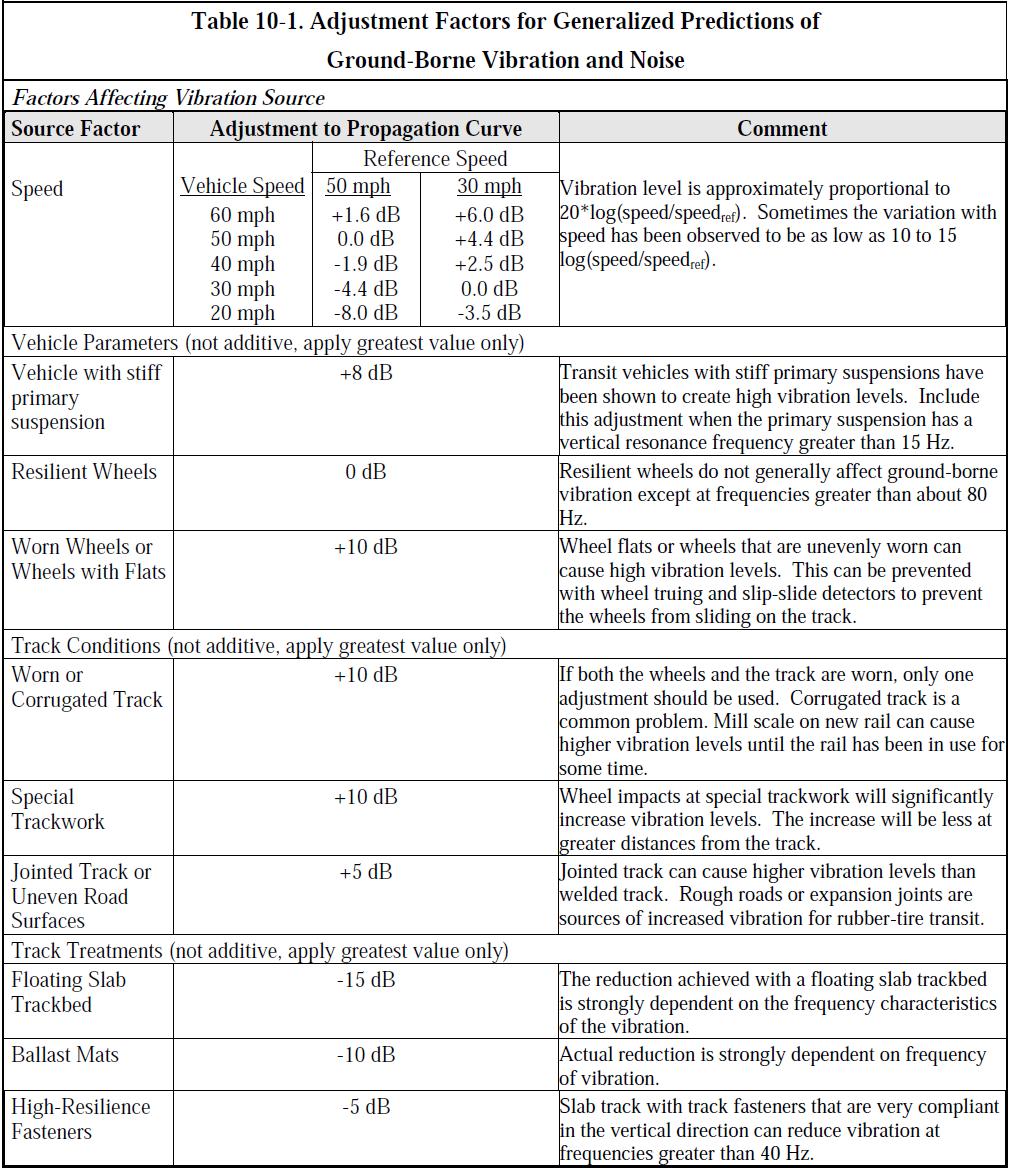
177 B3
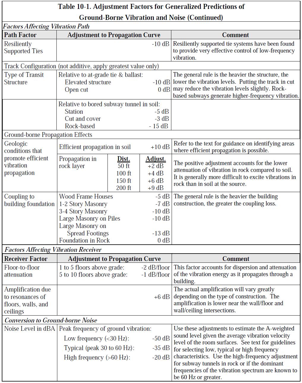
178 B4
Roadway Traffic Noise Assessment. 407 Nelson Street Ottawa, Ontario
 407 Nelson Street Ottawa, Ontario REPORT: GWE17-042 Traffic Noise Prepared For: Tony Kazarian AK Global Management Inc. 680 Eagleson Road Ottawa, Ontario K2M 2G9 Canada Prepared By: Omar Daher, B.Eng.,
Roadway Traffic Noise Feasibility Assessment. 315 Chapel Street. Ottawa, Ontario
 Roadway Traffic Noise Feasibility Assessment 315 Chapel Street Ottawa, Ontario REPORT: GWE17-002 - Traffic Noise Prepared For: Leanne Moussa Allsaints 10 Blackburn Avenue K1N 6P8 Ottawa, Ontario Prepared
Feasibility Noise Assessment. Westgate Shopping Centre Redevelopment. Ottawa, Ontario
 Feasibility Noise Assessment Westgate Shopping Centre Redevelopment Ottawa, Ontario REPORT: GWE15-067 - Feasibility Noise Prepared For: Stuart Craig 2300 Yonge Street, Suite 500 Toronto, Ontario M4P 1E4
Traffic Noise Impact Study. 383 Slater Street / 400 Albert Street. Ottawa, Ontario
 383 Slater Street / 400 Albert Street Ottawa, Ontario REPORT: GWE16-104 - Prepared For: Anand Aggarwal 2507701 Ontario Inc. Manor Park Management 231 Brittany Drive, Suite D Ottawa, Ontario K1K 0R8 Prepared
Transportation Noise Assessment. 590 Rideau Street. Ottawa, Ontario
 Transportation Noise Assessment 590 Rideau Street Ottawa, Ontario REPORT: GWE16-019 Transportation Noise Prepared For: Kevin Yemm Richcraft Group of Companies 2280 St. Laurent Boulevard, Suite 201 Ottawa,
Roadway Traffic Noise Feasibility Assessment. Conservancy Subdivision. Ottawa, Ontario
 Conservancy Subdivision Ottawa, Ontario REPORT: GWE17 151 Traffic Noise Prepared For: Andrew Finnson Barrhaven Conservancy East Inc. Ottawa, Ontario Prepared By: Joshua Foster, P.Eng., Principal Omar Daher,
Transportation Noise Assessment. 809 Richmond Road. Ottawa, Ontario
 Transportation Noise Assessment 809 Richmond Road Ottawa, Ontario REPORT: GWE16-024 - Transportation Noise Prepared For: Walter Boyce OCEF Corp 200-368 Slater Street Ottawa, Ontario K1R 5C1 Prepared By:
Transportation Noise Assessment. 560 Rideau Street. Ottawa, Ontario
 Transportation Noise Assessment 560 Rideau Street Ottawa, Ontario REPORT: GWE13-034 Transportation Noise Prepared For: Kevin Yemm Richcraft Group of Companies 2280 St. Laurent Boulevard, Suite 201 Ottawa,
Roadway Traffic Noise Feasibility Assessment. Conservancy Subdivision. Ottawa, Ontario
 Conservancy Subdivision Ottawa, Ontario REPORT: GWE17 151 Traffic Noise Prepared For: Andrew Finnson Barrhaven Conservancy East Inc. Ottawa, Ontario Prepared By: Joshua Foster, P.Eng., Principal Omar Daher,
Environmental Noise & Vibration Assessment
 Environmental Noise & Vibration Assessment City Park Redevelopment Phase 2 Ottawa, Ontario REPORT: GWE15-068 Noise & Vibration Phase 2 November 13, 2018 PREPARED FOR Stuart Craig RioTrin Prop (Gloucester
Transportation Noise Assessment. 121 Parkdale Avenue. Ottawa, Ontario
 Transportation Noise Assessment 121 Parkdale Avenue Ottawa, Ontario REPORT: GWE 14-010 - Traffic Noise Prepared For: Michel Gagnon 98 Rue Lois Gatineau, Québec J8Y 3R7 Prepared By: Thomas Couper, B.A.Sc.,
Transportation Noise Feasibility Assessment & 3930 Riverside Drive Ottawa, Ontario
 Transportation Noise Feasibility Assessment 3960 & 3930 Riverside Drive Ottawa, Ontario REPORT: GWE18 039 Transportation Noise Prepared For: Alex Turner 225 Metcalfe Street, Suite 708 Ottawa, Ontario K2P
Transportation Noise Assessment. 370 Queen Elizabeth Drive. Ottawa, Ontario
 Transportation Noise Assessment 370 Queen Elizabeth Drive Ottawa, Ontario REPORT: GWE14-121 - Traffic Noise REV 1 Prepared For: 2253664 Ontario Inc. Roberto Campagna 24 George Street West Ottawa, Ontario
Environmental Noise Assessment. St-Charles Market. Ottawa, Ontario
 Environmental Noise Assessment St-Charles Market Ottawa, Ontario REPORT: GWE15-120 - Noise Prepared For: Jenna Maw LineBox Studio Inc. 126 York Street, Suite 502 Ottawa, Ontario K1N 5T2 Prepared By: Michael
Environmental Noise and Vibration Assessments Place D Orleans Drive. Ottawa, Ontario
 s 1220-1226 Place D Orleans Drive Ottawa, Ontario REPORT: GWE17-154 Noise & Vibration Prepared For: Choice Properties REIT 22 St. Clair Avenue East, Suite 500 Toronto, ON M4T 2S5 c/o Pamela Whyte Parsons
Transportation Noise Assessment Prince of Wales Residential Development Ottawa, Ontario
 Transportation Noise Assessment 1003 Prince of Wales Residential Development Ottawa, Ontario REPORT: GWE13-031 - Traffic Noise Prepared For: Kent Bugatsch Inc. 63 Pamilla Street Ottawa, Ontario K1S 3K7
Noise Feasibility Study Proposed Residential Development (Infill) 747 Liverpool Road Pickering, Ontario
 747 Liverpool Road Pickering, Ontario") Noise Feasibility Study Proposed Residential Development (Infill) 747 Liverpool Road Pickering, Ontario Prepared for: Madison Liverpool Limited 369 Rimrock Road Toronto, Ontario, M3J 3G2 Prepared by Victor
Noise Feasibility Study Proposed Residential Development (Infill) 747 Liverpool Road Pickering, Ontario Prepared for: Madison Liverpool Limited 369 Rimrock Road Toronto, Ontario, M3J 3G2 Prepared by Victor
NOISE IMPACT ASSESSMENT 114 ISABELLA STREET RESIDENTIAL DEVELOPMENT OTTAWA, ONTARIO
 Smart Property Advisors Ltd. 802-500 Laurier Avenue West Ottawa, ON NOISE IMPACT ASSESSMENT 114 ISABELLA STREET RESIDENTIAL DEVELOPMENT OTTAWA, ONTARIO Prepared by: SMART PROPERTY ADVISORS LTD. 802 500
3443 INNES ROAD NOISE IMPACT ASSESSMENT REPORT
 3443 INNES ROAD NOISE IMPACT ASSESSMENT REPORT Prepared By: NOVATECH Suite 200, 240 Michael Cowpland Drive Kanata, Ontario K2M 1P6 December 2017 Novatech File No. 117077 Ref No.: R-2017-192 December 19,
J. E. COULTER ASSOCIATES LIMITED -ii- APPENDIX B: GUIDELINES
 J. E. COULTER ASSOCIATES LIMITED -ii- APPENDIX B: GUIDELINES NPC-115 NPC-115 Construction Equipment 1. Scope This Publication sets sound emission standards for various items of new construction
Transportation Noise Assessment. Salvation Army Multi Purpose Building 102 Bill Leathem Drive. Ottawa, Ontario
 Transportation Noise Assessment Salvation Army Multi Purpose Building 102 Bill Leathem Drive Ottawa, Ontario REPORT: GWE15-009 - Transportation Noise Prepared For: Michaela Jones The Salvation Army 2 Overlea
patersongroup Environmental Noise Control Study Proposed Multi-Storey Building 1088 Maritime Way - Ottawa Prepared For
 Geotechnical Engineering patersongroup Environmental Engineering Hydrogeology Geological Engineering Materials Testing Building Science Archaeological Services Environmental Noise Control Study Proposed
HABITAT FOR HUMANITY 2129 Nantes Street Detailed Noise Study
 HABITAT FOR HUMANITY 2129 Nantes Street Detailed Noise Study HABITAT FOR HUMANITY 2129 Nantes Street DETAILED NOISE STUDY Prepared by: NOVATECH ENGINEERING CONSULTANTS LTD. 240 Michael Cowpland Drive,
Transportation Noise Assessment. Salvation Army Multi Purpose Building 102 Bill Leathem Drive. Ottawa, Ontario
 Transportation Noise Assessment Salvation Army Multi Purpose Building 102 Bill Leathem Drive Ottawa, Ontario REPORT: GWE15-009 - Transportation Noise R2 Prepared For: Michaela Jones The Salvation Army
115 ECHO DRIVE CITY OF OTTAWA DETAILED NOISE STUDY
 Dix B 115 ECHO DRIVE CITY OF OTTAWA DETAILED NOISE STUDY Prepared for: UNIFORM URBAN DEVELOPMENTS Suite 300, 117 Centrepointe Drive Ottawa, Ontario K2G 5X3 Prepared by: NOVATECH Suite 200, 240 Michael
Transportation Noise Assessment. Salvation Army Multi-Purpose Building 102 Bill Leathem Drive. Ottawa, Ontario
 Transportation Noise Assessment Salvation Army Multi-Purpose Building 102 Bill Leathem Drive Ottawa, Ontario REPORT: GWE15-009 - Transportation Noise R3 Prepared For: Michaela Jones The Salvation Army
patersongroup Environmental Noise Control Study Proposed Multi-Storey Building 1136 Martime Way - Ottawa Prepared For
 Geotechnical Engineering patersongroup Environmental Engineering Hydrogeology Geological Engineering Materials Testing Building Science Archaeological Services Environmental Noise Control Study Proposed
REP Taggart 1140 Wellington Noise Control Study Page 1 of 18
 REP Taggart 1140 Wellington Noise Control Study Page 1 of 18 2013-10-15 Simon Taggart Project Coordinator The Taggart Group 3187 Albion Road South Ottawa, Ontario K1V 8Y3 T: 613.526.2400 ext 320 C: 613.857.0353
Appendix C STAMSON Noise Model Output File for Tunnel Alternative (Alternative 3)
") Appendix C STAMSON Noise Model Output File for Tunnel Alternative (Alternative 3) Detroit River International Crossing Study STAMSON 5.0 NORMAL REPORT Date: 21-02-2007 01:14:41 MINISTRY OF ENVIRONMENT
Appendix C STAMSON Noise Model Output File for Tunnel Alternative (Alternative 3) Detroit River International Crossing Study STAMSON 5.0 NORMAL REPORT Date: 21-02-2007 01:14:41 MINISTRY OF ENVIRONMENT
1 INTRODUCTION 4 2 NOISE DESCRIPTORS 5 3 NOISE SENSITIVE POINTS OF RECEPTION 5 4 PROPOSED LAND USE 7 5 GUIDELINES AND CRITERIA 8
 Durham Live Tourist Destination Page 2 of 24 29 May 2014 1 INTRODUCTION 4 2 NOISE DESCRIPTORS 5 3 NOISE SENSITIVE POINTS OF RECEPTION 5 4 PROPOSED LAND USE 7 5 GUIDELINES AND CRITERIA 8 5.1 ROAD & RAIL
DETAILED NOISE CONTROL STUDY PROPOSED TOWNHOUSE AND APARTMENT BUILDINGS BRONTE ROAD DEVELOPMENT TOWN OF OAKVILLE
 SS WILSON ASSOCIATES Consulting Engineers REPORT NO. WA10-93 REVISION 3 DETAILED NOISE CONTROL STUDY PROPOSED TOWNHOUSE AND APARTMENT BUILDINGS BRONTE ROAD DEVELOPMENT TOWN OF OAKVILLE SUBMITTED TO: BALLANTRY
Yorkdale Development Master Plan Environmental Noise and Vibration Feasibility Study Toronto, ON
 ASSESSMENT REPORT - Project: 16419 Yorkdale Development Master Plan Environmental Noise and Vibration Feasibility Study Toronto, ON Prepared for: Oxford Properties Group Royal Bank Plaza North Tower 200
MINISTRY OF TRANSPORTATION HIGHWAY 404 EXTENSION FINAL NOISE STUDY. Assignment Number: 2013-E-0017 #3
 MINISTRY OF TRANSPORTATION HIGHWAY 404 EXTENSION FINAL NOISE STUDY Assignment Number: 2013-E-0017 #3 Submitted to: The Ministry of Transportation 1201 Wilson Avenue Downsview, Ontario M3M 1J8 Submitted
Dubai Municipality LRT Noise and Vibration Impact Stage 2
 Dubai Municipality LRT Noise and Vibration Impact Stage 2 Environmental Impact 11 th of April, 2004 Environmental Impact Report According to the PS007 Agreement, Environmental Impact Report Based on Noise
APPENDIXD. Traffic Noise Technical Report
 APPENDIXD Traffic Noise Technical Report Environmental Assessment - Lincoln County, SD 85 th Street: Sundowner Avenue to Louise Avenue November 2017 F I N A L R E P O R T TRAFFIC NOISE TECHNICAL REPORT
Appendix E FTA NOISE MODELING WORKSHEETS AND DETAILED METHODOLOGY
 Appendix E FTA NOISE MODELING WORKSHEETS AND DETAILED METHODOLOGY APPENDIX E General Noise Assessment The FTA General Noise Assessment procedure was used for calculating noise from transit sources associated
APPENDIX IV MODELLING
 APPENDIX IV MODELLING Kingston Transportation Master Plan Final Report, July 2004 Appendix IV: Modelling i TABLE OF CONTENTS Page 1.0 INTRODUCTION... 1 2.0 OBJECTIVE... 1 3.0 URBAN TRANSPORTATION MODELLING
MEMORANDUM. The study area of the analysis was discussed with City staff and includes the following intersections:
 MEMORANDUM DATE: JULY 6, 2012 TO: FROM: RE: CC: MELANIE KNIGHT BRAD BYVELDS/ JENNIFER LUONG 1050 SOMERSET STREET PRELIMINARY TRAFFIC ANALYSIS OUR FILE NO. 111152 NEIL MALHOTRA The purpose of this memo
APPENDIX B. Noise Primer
 APPENDIX B Noise Primer NOISE PRIMER TABLE OF CONTENTS 1. INTRODUCTION...1 2. BASIC SOUND PRINCIPLES...1 2.1. SOUND AS A WAVE...1 2.2. SOUND PRESSURE LEVEL...2 2.2.1. Decibel Math...4 2.2.2. Descriptive
MAY 5, Noise Barrier Presentation SE Quadrant Noyes Street and Lincoln Street NOISE BARRIER ABUTTER MEETING. Tech Environmental, Inc.
 MAY 5, 2011 Noise Barrier Presentation SE Quadrant Noyes Street and Lincoln Street Jacobs Engineering Group Group Inc. Inc. 1 Introductions Agenda Overview of Interchange Project Overview of noise barrier
Noise Maps, Report & Statistics, Dublin City Council Noise Mapping Project Roads and Traffic Department
 Noise Maps, Report & Statistics, Dublin City Council Noise Mapping Project Roads and Traffic Department Produced by Traffic Noise & Air Quality Unit November 2007 Contact: brian.mcmanus@dublincity.ie Ph;
Pedestrian Level Wind Study. West Village 70 Mississauga Road South & 181 Lakeshore Road West. Mississauga, Ontario
 Pedestrian Level Wind Study West Village 70 Mississauga Road South & 181 Lakeshore Road West Mississauga, Ontario REPORT: GWE17-112-PLW Prepared For: c/o Emily Rosen Diamondcorp 22 St. Clair Avenue East,
1 Wind Turbine Acoustics. Wind turbines generate sound by both mechanical and aerodynamic
 Wind Turbine Acoustics 1 1 Wind Turbine Acoustics Wind turbines generate sound by both mechanical and aerodynamic sources. Sound remains an important criterion used in the siting of wind farms. Sound emission
Noise from Oil & Gas Facilities Acoustics 101 and Best Practices for Noise Control. Rob Stevens, HGC Engineering
 Noise from Oil & Gas Facilities Acoustics 101 and Best Practices for Noise Control Rob Stevens, HGC Engineering Noise From Oil & Gas Facilities Acoustics 101 and Best Practices for Noise Control Rob Stevens
Appendix G Noise Modeling Files
 Appendix G Noise Modeling Files County of Butte Rio d Oro Specific Plan Noise Study July 2014 Rio d Oro Specific Plan Noise Study Prepared for: JKB Development 2370 West Monte Vista Ave. Turlock, CA 95381
COULD THE GUNSHOT BE HEARD?
 COULD THE GUNSHOT BE HEARD? October 9, 2003 Paul D. Schomer Schomer & Associates Champaign, IL 61821 INTRODUCTION Statement of Problem On the evening of November 21, 1991, a NJ State Trooper gave chase
Paine Field Airport Existing and Future Environmental Assessment, Initiation of Commercial Service Noise Analysis
 Paine Field Airport Existing and Future Environmental Assessment, Initiation of Commercial Service Noise Analysis July 2012 Prepared by: BridgeNet International 3151 Airway Avenue Building I-2 Costa Mesa,
Re: Draft OPA 320 Recommended Amendments to Various Neighbourhood Policies Statutory Public Meeting to be held on Monday 16 November 2015
 PG8.5.5 ANALOGICA George S. Belza Partner 9 Madeline Road Toronto, Ontario Canada M2N 2S7 T: 416 223 9584 F: 416 223 5665 E: belana@axxent.ca E-Mailed to: pgmc@toronto.ca Wednesday 04 November 2015 Planning
APPENDIX 11A: BASELINE NOISE MONITORING RESULTS
 appendix 11a APPENDIX 11A: BASELINE NOISE MONITORING RESULTS Table 11.A.1: Summary of daytime noise measurements Location Time Measured Noise Levels (db re. 2x10⁻⁵ Pa) LAeq LA10 LA90 12:59 13:14 64 67
Answer - SAQ 1. The intensity, I, is given by: Back
 Answer - SAQ 1 The intensity, I, is given by: Noise Control. Edited by Shahram Taherzadeh. 2014 The Open University. Published 2014 by John Wiley & Sons Ltd. 142 Answer - SAQ 2 It shows that the human
1600 Prairie Drive , FAX
 Hennepin County Transportation Department Transportation Department 612-596-0300, Phone 1600 Prairie Drive 612-321-3410, FAX Medina, MN 55340-5421 www.hennepin.us December 30, 2015 Subject: Bottineau Boulevard
APPENDIX Q BLASTING IMPACT ASSESSMENT REPORT
 APPENDIX Q BLASTING IMPACT ASSESSMENT REPORT BLASTING IMPACT ASSESSMENT: FUTURE BLASTING OPERATIONS AT THE MOOSE RIVER OPEN PIT GOLD MINE DEVELOPMENT SITE TOUQUOY GOLD PROJECT MOOSE RIVER, HALIFAX COUNTY,
Fundamentals of Sound
 Sound is an important consideration in the selection of mechanical equipment. The purpose of this article is to present a procedure for evaluating the sound levels created by evaporative cooling equipment
WEST VALLEY BOULEVARD MIXED USE PROJECT NOISE IMPACT ANALYSIS. January 9, 2015
 400-420 WEST VALLEY BOULEVARD MIXED USE PROJECT NOISE IMPACT ANALYSIS January 9, 2015 Kunzman Associates, Inc. 400-420 WEST VALLEY BOULEVARD MIXED USE PROJECT NOISE IMPACT ANALYSIS January 9, 2015 Prepared
Assessment & Specifications for Noise Controls
 Project 772600 Rev 1 Cargill North Vancouver Grain Terminal Assessment & Specifications for Noise Controls TABLE OF CONTENTS 1. INTRODUCTION...1 1.1 Background...1 1.2 Site Description...1 2. SOUND LEVEL
Directive on the Assessment and Management of Environmental Noise
 Directive on the Assessment and Management of Environmental Noise This Directive has been ratified by the European Parliament and is awaiting publication in the Official Journal.( around 23/5/02) The Directive
ENVIRONMENTAL NOISE IMPACT ASSESSMENT
 REPORT REFERENCE: SA 4968 rev 1 ENVIRONMENTAL NOISE IMPACT ASSESSMENT British Standard 8233: 2014. CLIENT: MJ Gleeson SITE: Berengrave Nursery, 61 Berengrave Road, Rainham, Kent, ME 7NL SURVEY DATES: Noise
GIS-BASED VISUALISATION OF TRAFFIC NOISE
 Proceedings of the 9 th International Conference on Environmental Science and Technology Rhodes island, Greece, 1 3 September 2005 GIS-BASED VISUALISATION OF TRAFFIC NOISE A. KONSTANTINIDIS 1, K. EVANGELIDIS
Forecasts for the Reston/Dulles Rail Corridor and Route 28 Corridor 2010 to 2050
 George Mason University Center for Regional Analysis Forecasts for the Reston/Dulles Rail Corridor and Route 28 Corridor 21 to 25 Prepared for the Fairfax County Department of Planning and Zoning Lisa
Regal House #CREATESOMETHING. ALL ENQUIRIES 53,647 sq.ft. RE-DEVELOPMENT OPPORTUNITY SUITABLE FOR A VARIETY OF USES OFFICE HOTEL RESIDENTIAL
 SK1 3AA #CREATESOMETHING RE-DEVELOPMENT OPPORTUNITY OFFICE HOTEL RESIDENTIAL Stockport has everything Excellent motorway access First class rail links Efficient local bus services Easy access to Manchester
Rio Tinto- Compagnie minière IOC
 Rio Tinto- Compagnie minière IOC Noise and Vibration Impact Assessment, Wabush 3 Pit, West Labrador Prepared For: Iron Ore Company of Canada/Standard Consulting 2 Avalon Drive, Labrador City Newfoundland
CERTIFIED RESOLUTION. introduction: and dated May 29, 2017, as attached, as appropriate
 15322 Buena Vista Avenue, White Rock BC, Canada V4B 1Y6 www.whiterockcity.ca City of White Rock P: 604.541.22121 F: 604.541.9348 /2tC% City Clerk s Office IT E ROC K June 13,2017 Stephanie Lam, Deputy
III. FORECASTED GROWTH
 III. FORECASTED GROWTH In order to properly identify potential improvement projects that will be required for the transportation system in Milliken, it is important to first understand the nature and volume
Snow and Ice Control POLICY NO. P-01/2015. CITY OF AIRDRIE Snow and Ice Control Policy
 Page 1 CITY OF AIRDRIE Snow and Ice Control Effective Date: Approved By: Approved On: March 17, 2015 City Council March 16, 2015 Revision Date: Resolution #: ------ PURPOSE: The City of Airdrie is responsible
METRO Blue Line LRT Extension (BLRT) 5514 West Broadway Avenue, Suite 200, Crystal, MN
 5514 West Broadway Avenue, Suite 200, Crystal, MN") Robbinsdale Open House July 28, 2015 *All comments are recorded verbatim from comment cards and discussion worksheets. No grammatical, word choice changes or spelling has been corrected. If handwriting
Robbinsdale Open House July 28, 2015 *All comments are recorded verbatim from comment cards and discussion worksheets. No grammatical, word choice changes or spelling has been corrected. If handwriting
PW 001 SNOW REMOVAL AND SANDING FOR ROADWAYS AND SIDEWALKS October 6, 2014 (#223-14) Original October 19, 2015; October 15, 2018 Public Works
 Original October 19, 2015; October 15, 2018 Public Works") Policy Statement: The Village of Kitscoty will provide snow and ice control on municipal streets and sidewalks according to determined priorities. Purpose: To provide direction and information to employees
Policy Statement: The Village of Kitscoty will provide snow and ice control on municipal streets and sidewalks according to determined priorities. Purpose: To provide direction and information to employees
High Speed / Commuter Rail Suitability Analysis For Central And Southern Arizona
 High Speed / Commuter Rail Suitability Analysis For Central And Southern Arizona Item Type Reports (Electronic) Authors Deveney, Matthew R. Publisher The University of Arizona. Rights Copyright is held
COUNCIL POLICY MANUAL
 COUNCIL POLICY MANUAL SECTION: PUBLIC WORKS SUBJECT: SNOW & ICE CONTROL POLICY 2012/2013 GOAL: Pages: 1 of 10 Approval Date: Dec. 3, 2012 Res. # 1001/2012 To annually identify the winter maintenance costs
Chapter 11. Noise Impacts of Transportation Systems. Transportation Decision-making Principles of Project Evaluation and Programming
 Transportation Decision-making Principles of Project Evaluation and Programming Chapter 11 Noise Impacts of Transportation Systems Kumares Sinha and Samuel Labi 1 2 Real Experiences of Transportation Noise
FINAL REPORT. On Project Supplemental Guidance on the Application of FHWA s Traffic Noise Model (TNM) APPENDIX J Wind and Temperature Gradients
 APPENDIX J Wind and Temperature Gradients") FINAL REPORT On Project 25-34 Supplemental Guidance on the Application of FHWA s Traffic Noise Model (TNM) APPENDIX J Wind and Temperature Gradients Prepared for: National Cooperative Highway Research
FINAL REPORT On Project 25-34 Supplemental Guidance on the Application of FHWA s Traffic Noise Model (TNM) APPENDIX J Wind and Temperature Gradients Prepared for: National Cooperative Highway Research
Appendixx C Travel Demand Model Development and Forecasting Lubbock Outer Route Study June 2014
 Appendix C Travel Demand Model Development and Forecasting Lubbock Outer Route Study June 2014 CONTENTS List of Figures-... 3 List of Tables... 4 Introduction... 1 Application of the Lubbock Travel Demand
Monitoring Survey in the Vicinity of St. Marys Cement: Interim Report
 Technical Memorandum 2017-2018 Monitoring Survey in the Vicinity of St. Marys Cement: Interim Report Ontario Ministry of the Environment & Climate Change Report Prepared by: Terrestrial Assessment and
SHADOW STUDY REPORT REGARDING
 SHADOW STUDY REPORT REGARDING an APPLICATION TO REDEVELOP Three 6 Storey Condominiums Regional Road 25 (Ontario Street) and Britannia Road Milton, Ontario KNYMH FILE # 17030 Prepared by: Krista Lilley
East Bay BRT. Planning for Bus Rapid Transit
 East Bay BRT Planning for Bus Rapid Transit Regional Vision Draper Prison The Bottleneck is a State-Level issue, Salt Lake County 2050 Population: 1.5M Draper Prison hopefully with some State-Level funding!
research highlight Wind-Rain Relationships in Southwestern British Columbia Introduction Methodology Figure 2 Lower Mainland meteorological stations
 research highlight June 2007 Technical Series 07-114 Introduction Building envelope failures in southwestern British Columbia has brought to light the strong influence of wind-driven rain on building envelopes.
conceptdesigns C0NCEPTDESIGNSARCHITETURE.CO.NZ architecture S t a g e Gisborne Beach House
 C0NCEPTDESIGNSARCHITETURE.CO.NZ conceptdesigns architecture S t a g e 2 A Gisborne Beach House GISBORNE BEACH BRIEF HOUSE conceptdesigns architecture Beth and Chris want to design and build their forever
Neighborhood Locations and Amenities
 University of Maryland School of Architecture, Planning and Preservation Fall, 2014 Neighborhood Locations and Amenities Authors: Cole Greene Jacob Johnson Maha Tariq Under the Supervision of: Dr. Chao
Effect of Environmental Factors on Free-Flow Speed
 Effect of Environmental Factors on Free-Flow Speed MICHAEL KYTE ZAHER KHATIB University of Idaho, USA PATRICK SHANNON Boise State University, USA FRED KITCHENER Meyer Mohaddes Associates, USA ABSTRACT
The Governance of Land Use
 The planning system The Governance of Land Use United Kingdom Levels of government and their responsibilities The United Kingdom is a unitary state with three devolved governments in Northern Ireland,
Experimental validation of a numerical model for the ground vibration from trains in tunnels
 Experimental validation of a numerical model for the ground vibration from trains in tunnels Qiyun Jin; David Thompson; Daniel Lurcock; Martin Toward; Evangelos Ntotsios; Samuel Koroma Institute of Sound
Appendix N Noise Study
 Appendix N Noise Study NOTICE The information contained in this Appendix was developed strictly for the purpose of evaluating the environmental impacts associated with the Ambassador Bridge Enhancement
1.0 BACKGROUND. January 6, 2006 Proj #
 January 6, 2006 Proj # 4565-01 Mr. Eugene Wat Director of Engineering City of Port Moody 100 Newport Drive Box 36 Port Moody, BC V3H 3E1 Dear Mr. Wat: RE: ALDERSIDE ROAD & IOCO ROAD PEDESTRIAN CROSSING
Tornadoes. Be able to define what a tornado is. Be able to list several facts about tornadoes.
 Tornadoes Be able to define what a tornado is. Be able to list several facts about tornadoes. 1. Where do tornadoes most U.S. is # 1 occur in the world? Tornadoes are most common in Tornado Alley. Tornado
ARCHITECTURE IN THE DAYLIGHT
 ARCHITECTURE IN THE DAYLIGHT Site Location MANUS LEUNG HARVARD GSD FALL 2015 The house is located in Jl. Intern Corn Kebun Jeruk Blok U3 No.18, Kembangan District of Jakarta 11640 Indonesia. 01 OBJECTIVES
Risk Assessment and Mitigation. Hurricane Checklist
 Risk Assessment and Mitigation Hurricane Checklist Hurricane Checklist Hurricanes are severe tropical storms with sustained winds of at least 74 miles per hour. Hurricane winds can reach 160 miles per
Parking Regulations Dundas Street West, from Bathurst Street to Dovercourt Road
 STAFF REPORT ACTION REQUIRED Parking Regulations Dundas Street West, from Bathurst Street to Dovercourt Road Date: October 28, 2008 To: From: Toronto and East York Community Council Director, Transportation
Building Envelope Requirements Overview Page 3-4
 Building Envelope Requirements Overview Page 3-4 The benefit of a high reflectance surface is obvious: while dark surfaces absorb the sun s energy (visible light, invisible infrared. and ultraviolet radiation)
Mitigation of Gypsum Mine Voids Under SR-2 in Ottawa County, Ohio
 Subsurface Investigation and Conceptual Alternatives Mitigation of Gypsum Mine Voids Under SR-2 in Ottawa County, Ohio Presented By: Ohio Department of Transportation CH2M HILL CTL Engineering Technos,
STAFF REPORT ACTION REQUIRED
 STAFF REPORT ACTION REQUIRED Appeal by Fast Signs of the Decision of the Chief Building Official for One Variance Respecting a Proposed First Party Wall Sign 10-21 Four Seasons Place Date: January 18,
Published in: Proceeding of 9th SENVAR / 2nd ISESEE, Shah Alam, Malaysia, December 2008
 Evaluation on Lighting Condition and Visual Legibility of Road Surfaces and Traffic Signs in Bandung City Mangkuto, R.A.; Soelami, F.X.N.; Soegijanto, R.M. Published in: Proceeding of 9th SENVAR / 2nd
FIRST, MORE ABOUT SOUND
 FIRST, MORE ABOUT SOUND www.fullbhuna.co.uk/images/ www.privateline.com/telephonehistory/ ways of describing sound in architectural acoustics Ball State Architecture ENVIRONMENTAL SYSTEMS 1 Grondzik 1
The LakeFront Collection
 The LakeFront Collection I l l u s t r at i o n s a re a r t i s t s i m p re s s i o n s. S p e cifi c at i o n s a re s u b j e c t to c h a n ge w i t h o u t n ot i ce. E. & O. E. The LakeFront Collection
4.A.3 SHADE/SHADOW 1. INTRODUCTION. 2. ENVIRONMENTAL SETTING a. Existing Conditions. (1) Project Vicinity 4.A.3 1
 Project Vicinity 4.A.3 1") 4.A.3 SHADE/SHADOW 1. INTRODUCTION This section describes the potential for the Project to result in shade/shadow impacts. New construction has the potential to block sunlight from land uses that are sensitive
4.A.3 SHADE/SHADOW 1. INTRODUCTION This section describes the potential for the Project to result in shade/shadow impacts. New construction has the potential to block sunlight from land uses that are sensitive
HOTEL KANATA 160 HEARST WAY KANATA, ONTARIO SERVICING REPORT. Prepared for: David Johnston Architect. Prepared By:
 HOTEL KANATA 160 HEARST WAY KANATA, ONTARIO SERVICING REPORT Prepared for: David Johnston Architect Prepared By: BaseTech Consulting Inc. 309 Roywood Crescent Newmarket, Ontario L3Y 1A6 BCI Project No.
Town of Bowden Province of Alberta Policy Document ( ) SNOW REMOVAL POLICY
 SNOW REMOVAL POLICY") Town of Bowden Box 338, 2101 20 th Ave Bowden, Alberta, T0M 0K0 Town of Bowden Province of Alberta Policy Document (2019-01) SNOW REMOVAL POLICY 1 INTRODUCTION The purpose of this policy is to establish
Town of Bowden Box 338, 2101 20 th Ave Bowden, Alberta, T0M 0K0 Town of Bowden Province of Alberta Policy Document (2019-01) SNOW REMOVAL POLICY 1 INTRODUCTION The purpose of this policy is to establish
POLICY MANUAL. Hamlets/Residential named hamlets within the County of Grande Prairie whose roads are hard surfaced.
 POLICY MANUAL Legal References: Policy department: Public Works Department Cross References: N7 Adoption Date: January 19, 2005 Revision Date: June 20, 2005 Motion# 06/662/2005 October 20, 2014 Motion#
IV. ENVIRONMENTAL IMPACT ANALYSIS B. AESTHETICS SHADE/SHADOW
 IV. ENVIRONMENTAL IMPACT ANALYSIS B. AESTHETICS SHADE/SHADOW 1. INTRODUCTION Potential effects of the Proposed Project related to visual character, views and light/glare are addressed in Section IV.A,
October 16, Dear Mr. Hawkins:
 IBI GROUP 101 410 Albert Street Waterloo ON N2L 3V3 Canada tel 519 585 2255 fax 519 585 2269 October 16, 2017 Mr. Trevor Hawkins Manager of Applications and Implementation Integrated Planning and Public
Appendix 8I. Population and Community Use Analysis. December 2010
 Appendix 8I Population and Community Use Analysis December 2010 APPENDIX 8I Population and Community Use Analysis December 2010 Prepared for: Prepared by: 20 Bay Street, Suite 901 Toronto ON M5J 2N8 In
HAZUS-MH: Earthquake Event Report
 HAZUS-MH: Earthquake Event Report Region Name: El Paso County Earthquake Scenario: El Paso County Random EQ Print Date: February 08, 2006 Disclaimer: The estimates of social and economic impacts contained