12"CMP DIA. ELEV. PVC CI DI CMP VCP RCP RCAP LRCP LCPP STA. LA LB BM-2 ROW PI POT LF TH PVC
|
|
|
- Magnus Scott
- 5 years ago
- Views:
Transcription


1 PLANS FOR X-REFS: FILE PATH: Z:\WEST BRANCH 3682 MAIN STREET SIDEWALK IMPROVEMENTS - PHASE 3\DRAWINGS\_PRODUCTION DRAWINGS\TITLE & INDEX PLOTTED: Thursday, May 26, 216 4:7:42 PM MAIN STREET SIDEWALK PHASE - 3 a W psinonoc Creek LOCATION 8 CITY OF WEST BRANCH VICINITY MAP NOT TO 8"S 18"ST 8"W 6"FM 4"G UE OHE T CTV FO OR OR OR GENERAL LEGEND SURVEY LINE & STATION INDICATOR CONCRETE SURFACE ASPHALT SURFACE CONCRETE W/ASPHALT OVERLAY LOW GRADE ASPHALT SURFACE GRANULAR SURFACE DIRT SURFACE BRICK SURFACE SURFACING REMOVAL/REPLACEMENT EARTH SECTION NEW SEWER/MANHOLE NEW SEWER/INTAKE NEW WATER MAIN NEW FORCE MAIN NEW HYDRANT NEW WATER VALVE EXISTING SANITARY SEWER AND SIZE EXISTING STORM SEWER AND SIZE EXISTING WATER MAIN AND SIZE EXISTING FORCE MAIN AND SIZE GAS MAIN AND SIZE UNDERGROUND POWER LINE OVERHEAD POWER LINE UNDERGROUND TELEPHONE LINE CABLE TELEVISION LINE FIBER OPTICS TOP OF EMBANKMENT TOE OF EMBANKMENT DRAINAGE COURSE SANITARY MANHOLE STORM WATER MANHOLE ELECTRIC MANHOLE TELEPHONE MANHOLE WATER MANHOLE CURB INTAKE AREA OR BEEHIVE INTAKE EXISTING HYDRANT EXISTING WATER VALVE GAS VALVE UTILITY POLE GUY ANCHOR STREET LIGHT SIGN TELEPHONE CABLE JUNCTION BOX TRAFFIC SIGNALS PEDESTRIAN CONTROL LIGHT RAILROAD CONTROL LIGHT RAILROAD SIGN UTILITY ACCESS COVER PARKING METER TREE EVERGREEN STUMP BUSH, SHRUB OR HE 12"CMP CULVERT; SIZE AND TYPE FLARED END SECTION RAILROAD MAILBOX FENCE (MISC.) SECURITY FENCE WOOD FENCE SILT FENCE CHAIN LINK FENCE PROPERTY LINE PROPERTY PIN SECTION CORNER PLAT BOUNDARY BUILDING ELEVATION MARKER CENTERLINE DIAMETER ELEVATION POLYVINYLCHLORIDE PIPE CAST IRON PIPE DUCTILE IRON PIPE CORRUGATED METAL PIPE VITRIFIED CLAY PIPE REINFORCED CONCRETE PIPE REINFORCED CONCRETE ARCH PIPE LINED REINFORCED CONCRETE PIPE LINED CONCRETE PRESSURE PIPE STATION LINE AHEAD LINE BACK BENCH MARK AND NUMBER RIGHT-OF-WAY POINT OF INTERSECTION POINT ON TANGENT LINEAR FEET TACKED HUB SOIL BORING AND NUMBER POINT OF VERTICAL CURVATURE POINT OF VERTICAL TANGENCY VERTICAL CURVE POINT OF CURVATURE POINT OF TANGENCY MIDDLE ORDINATE DRAWING CONTROL POINT AND NUMBER TYPICAL HIGH PRESSURE GAS INTERMEDIATE PRESSURE GAS INVERT EACH WAY, EACH FACE EACH WAY AT DRAWING NUMBER NOTE: THIS IS A GENERAL LEGEND. ITEMS MAY OR MAY NOT APPEAR ON DRAWINGS. OR SF PL C L DIA. ELEV. PVC CI DI CMP VCP RCP RCAP LRCP LCPP STA. LA LB BM-2 ROW PI POT LF TH * SB-2 PVC PVT VC PC PT MO DWG. CP-1 (TYP.) HPG IPG INV. E.W.,E.F. 3 NO. DRAWING TITLE 1 INDEX AND TITLE SHEET DRAWING INDEX DETAILS SHEETS QUANTITIES & ESTIMATE REFERENCE DEMOLITION PLAN SITE PLAN CONTROL SIDEWALK STAKING GENERAL NOTES 1. ALL ELEVATIONS ARE TO CITY OF WEST BRANCH DATUM. 2. REMOVE AND REPLACE ALL STREET SIGNS AS DIRECTED BY ENGINEER. COST IS INCIDENTAL TO. 3. SHAPE ALL DITCHES TO DRAIN AFTER. 4. CONFIRM LOCATION AND DEPTH OF ALL EXISTING UNDERGROUND UTILITIES AS REQUIRED TO ELIMINATE CONFLICTS PRIOR TO. ALLOW UTILITY PERSONNEL TO RELOCATE UTILITIES WHERE CONFLICTS OCCUR. 5. DO NOT INTERRUPT EXISTING UTILITIES OR INDIVIDUAL SERVICES UNLESS DIRECTED BY ENGINEER. 6. LOCATIONS OF LIMIT LINES SHOWN ON PLANS ARE APPROXIMATE. ENGINEER WILL LOCATE LIMITS IN FIELD. CONFINE ALL OPERATIONS, INCLUDING ACCESS TO WORK, TO LIMITS. 7. SET MANHOLE COVERS FLUSH WITH PROPOSED GRADES UNLESS OTHERWISE NOTED. 8. STATIONING IS ALONG E OF SIDEWALK, UNLESS OTHERWISE NOTED. 9. PROTECT UTILITY POLES, LINES AND APPURTENANCES NOT SHOWN FOR RELOCATION. 1. RESET ALL PROPERTY PINS DISTURBED BY ; PINS RESET BY REGISTERED LAND SURVEYOR; COST IS INCIDENTAL TO. 11. PROTECT ALL SURFACING, NOT INDICATED BY SHADING FOR REMOVAL AND REPLACEMENT FROM DAMAGE DURING. PROTECTION OF VEGETATION TREES AND OTHER VEGETATION WHICH MAY BE REMOVED ARE MARKED WITH AN "X" OVER THE APPROPRIATE SYMBOL. FOR EXAMPLE 12" INDICATES THE REMOVAL OF A 12" TREE. REPLACEMENT, BY CONTRACTOR, OF THESE ITEMS IS NOT REQUIRED. TUNNEL, INSTALL TIGHT SHEETING, HAND EXCAVATE OR EMPLOY OTHER MEANS BY ENGINEER TO PROTECT EXPOSED PORTIONS AND ROOT SYSTEMS OF TREES AND OTHER VEGETATION NOT SCHEDULED FOR REMOVAL. IF TREES AND OTHER VEGETATION NOT SCHEDULED FOR REMOVAL ARE DAMAGED DURING, REPLACE IN KIND AND SIZE AT NO COST TO CITY OR PROPERTY OWNER. TITLE AND INDEX SHEET


2 PLOTTED: Thursday, May 26, 216 4:7:49 PM FILE PATH: Z:\WEST BRANCH 3682 MAIN STREET SIDEWALK IMPROVEMENTS - PHASE 3\DRAWINGS\_PRODUCTION DRAWINGS\DETAILS X-REFS: DETAILS


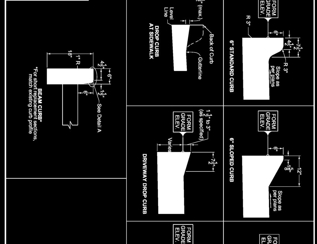

3 PLOTTED: Thursday, May 26, 216 4:7:54 PM FILE PATH: Z:\WEST BRANCH 3682 MAIN STREET SIDEWALK IMPROVEMENTS - PHASE 3\DRAWINGS\_PRODUCTION DRAWINGS\DETAILS X-REFS: DETAILS
4 TABULATION OF UTILITIES X-REFS: FILE PATH: Z:\WEST BRANCH 3682 MAIN STREET SIDEWALK IMPROVEMENTS - PHASE 3\DRAWINGS\_PRODUCTION DRAWINGS\QUANTITIES PLOTTED: Thursday, May 26, 216 4:8:3 PM ESTIMATED ROADWAY QUANTITIES ITEM NO. ITEM UNIT TOTAL AS BUILT QUAN. 1 MOBILIZATION LS 1 2 STAKING LS 1 3 TRAFFIC CONTROL LS 1 4 PAVEMENT REMOVAL 4.1 HMA PAVEMENT SY PCC CURB LF SIDEWALK SY MILL 2" HMA SY FIXTURE ADJUSTMENT 6.1 CURB STOPS EA MANHOLE EA 2 7 MODIFIED SUBBASE CY 1 8 HMA 1M PAVEMENT TONS " PCC SIDEWALK SY CURB & GUTTER LF DETECTABLE RAMPS SF 28 ESTIMATE REFERENCE INFORMATION ITEM NO. ITEM CODE DESCRIPTION 1 MOBILIZATION LUMP SUM 2 STAKING LUMP SUM 3 TRAFFIC CONTROL LUMP SUM 4 PAVEMENT REMOVAL 4.1 HMA PAVEMENT SEE DEMOLITION SHEET, REMOVE 7" HMA PAVEMENT 2 FEET FROM CURB FOR NEW CURB FORMS. 4.2 PCC CURB SEE DEMOLITION SHEET 4.3 SIDEWALK SEE DEMOLITION SHEET, PROTECT PRIVATE PROPERTY 5 MILL 2" HMA SEE DEMOLITION SHEET MILL 2" TO APPLY NEW HMA TO BLEND ROAD TO NEW 6 FIXTURE ADJUSTMENT 6.1 CURB STOPS SEE PLAN SHEET RAISE AS NEEDED, NOTIFY PROPERTY OWNERS 6.2 MANHOLE SEE PLAN SHEET RAISE AS NEEDED 7 MODIFIED SUBBASE AS NEEDED UNDER NEW 8 HMA 1M PAVEMENT SEE PLAN SHEET APPLY TO BLEND ROAD TO NEW 9 6" PCC SIDEWALK SEE PLAN & SIDEWALK SHEET 1 CURB & GUTTER SEE PLAN & SIDEWALK SHEETS 11 DETECTABLE RAMPS SEE PLAN SHEET QUANTITIES & ESTIMATE REFERENCE

5 X-REFS: 3682 Topo & Aerial FILE PATH: Z:\WEST BRANCH 3682 MAIN STREET SIDEWALK IMPROVEMENTS - PHASE 3\DRAWINGS\_PRODUCTION DRAWINGS\DEMOLITION PLOTTED: Thursday, May 26, 216 4:8:16 PM ' 1' 2' DEMOLITION PLAN

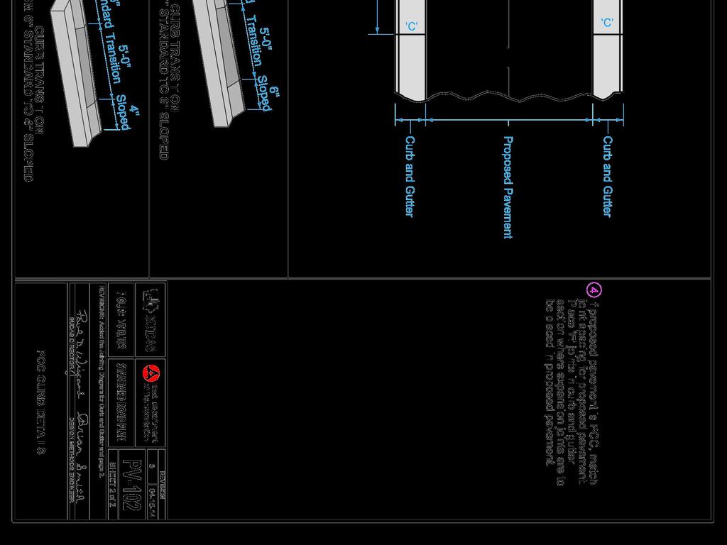
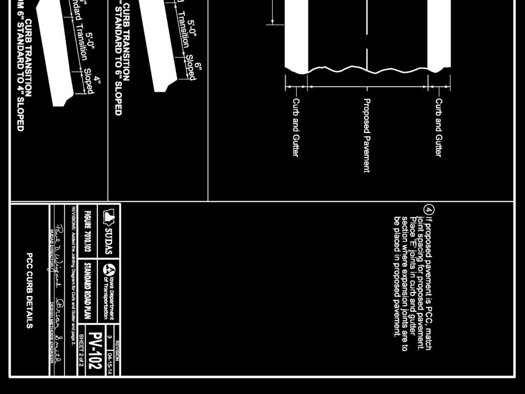
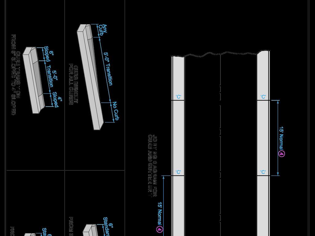
6 X-REFS: Aerial & 3682 Topo FILE PATH: Z:\WEST BRANCH 3682 MAIN STREET SIDEWALK IMPROVEMENTS - PHASE 3\DRAWINGS\_PRODUCTION DRAWINGS\PLAN PLOTTED: Thursday, May 26, 216 4:8:29 PM NOTES: ' 1' 2' 1. CONTRACTOR TO CONSTRUCT CURB ALONG BUILDING FACE IN CONJUNCTION WITH CONSTRUCTING SIDEWALK. CURB SHALL BE BUILT WITH VARYING DEGREE OF HEIGHT AND SLOPE TO MASK BUILDING FACE. COST IS INCIDENTAL TO SIDEWALK COST. 2. CONTRACTOR TO CONSTRUCT 6" SLOPED CURB PER IOWA STANDARD ROAD PLAN PV CITY WILL HAVE ELECTRICAL CONTRACTOR INSTALL CONDUIT TO LIGHT POLES ONCE PAVEMENT IS REMOVED. COORDINATE WITH CITY TO PROVIDE 1 WEEK NOTICE PRIOR TO REMOVAL. 4. INSTALL EXPANSION JOINT MATERIAL AROUND LIGHT POLE BASE. SITE PLAN

7 X-REFS: Topo & Arieal 2 FILE PATH: Z:\WEST BRANCH 3682 MAIN STREET SIDEWALK IMPROVEMENTS - PHASE 3\DRAWINGS\_PRODUCTION DRAWINGS\CONTROL PLOTTED: Thursday, May 26, 216 4:8:42 PM ' 2' 4' CONTROL POINT TABLE Control # Description Northing Easting Elevation CONTROL
8 Point # Raw Description Northing Easting Elevation Point # Raw Description Northing Easting Elevation Point # Raw Description Northing Easting Elevation X-REFS: Aerial & 3682 Topo & Design FILE PATH: Z:\WEST BRANCH 3682 MAIN STREET SIDEWALK IMPROVEMENTS - PHASE 3\DRAWINGS\_PRODUCTION DRAWINGS\SIDEWALK PLOTTED: Thursday, May 26, 216 4:8:59 PM ' 5' 1' SIDEWALK STAKING
9 X-REFS: Aerial & 3682 Topo & Design FILE PATH: Z:\WEST BRANCH 3682 MAIN STREET SIDEWALK IMPROVEMENTS - PHASE 3\DRAWINGS\_PRODUCTION DRAWINGS\SIDEWALK PLOTTED: Thursday, May 26, 216 4:9:4 PM Point # Raw Description Northing Easting Elevation ' 5' 1' Point # Raw Description Northing Easting Elevation Point # Raw Description Northing Easting Elevation SIDEWALK STAKING
20217 CLEAR STONE TON $14.20 $5, $ $ $ %
 ACCOUNT NO: 10332-84-174-84300: 54250(91223) ACCOUNT NO: 10529-403-172: 54440 (91226) ACCOUNT NO: 10463-51-130: 54250 (91223) ACCOUNT NO: 10332-84-174-84300: 54250 (91223) 20217 CLEAR STONE 375.00 TON
10701 TRAFFIC CONTROL 1.00 LUMP SUM $4, $4, $ $4, $4, %
 ACCOUNT NO. 10154-403-172 ACCOUNT NO. 10154-403-174 ACCOUNT NO. 11712-84-174-84600 ACCOUNT NO. 10154-403-172 10701 TRAFFIC CONTROL 1.00 LUMP SUM $4,000.00 $4,000.00 0.00 $0.00 1.00 $4,000.00 1.00 $4,000.00
20217 CLEAR STONE TON $14.20 $5, $ $ $ %
 ACCOUNT NO: 10332-84-174-84300: 54250(91223) ACCOUNT NO: 10529-403-172: 54440 (91226) ACCOUNT NO: 10463-51-130: 54250 (91223) ACCOUNT NO: 10332-84-174-84300: 54250 (91223) 20217 CLEAR STONE 375.00 TON
Addendum No: 1 THE FOLLOWING IS BEING ISSUED AS ADDENDUM NO. 1 PLEASE REVIEW THE FOLLOWING PAGES. Firm: Address
 CITY OF WACO Purchasing Services Post Office Box 2570 Waco, Texas 76702-2570 254 / 750-6640 Fax: 254 / 750-8063 www.waco-texas.com Date: 11/6/17 RFB No: 2017-066 Commodity: Sidewalk Improvement Plans Closing
Franklin County Engineer's Office - Highway Design Dublin Road And Fishinger Road Improvements Rebid Bid Tabulation
 2/20/2015 Page 1 of 16 Strawser Paving Co., Inc. Double Z Construction Co Decker Construction Company Shelly & Sands, Inc. 1595 Frank Road 2550 Harrison Road 3040 McKinley Avenue P.O.Box 2469 Columbus,
 ORIGINATOR: CITY OF MADISON STREETS DIVISION REV. DATE: _ PLOT NAME: _ PLOT SCALE: _ SHORELINE TREATMENT SCHEDULE PROJECT NO. 10332/10529 U-10 SHORELINE TREATMENT SCHEDULE MAINLAND CITY OF MADISON MAINLAND
ISSUED FOR CONSTRUCTION
 PAGE No. DESCRIPTION 1 Cover Page 2 Overview Map 3 Western Road Plan View 4 Eastern Road Plan View West Road Profiles & Cross Sections 6-7 East Road Profiles 8- East Road Cross Sections 11-14 Campsite
New Jersey Department of Transportation DATE : 04/10/12 PAGE : TABULATION OF BIDS
 PAGE : 421-1 CONTRACT TIME : 12/15/12 COMPLETION DATE CONTRACT DESCRIPTION : PROJECT(S) : 100% STATE MAINTENANCE ROADWAY REPAIR CONTRACT CENTRAL, CONTRACT NO. C204, DP 11421 ROUTES US 1 NB & SB, 18 NB
BACKGROUND AND PROJECT DESCRIPTION
 June 7, 2017 Applicant: Murdock Builders Location: Approximately 600 West 1200 North Prepared by: Brian Tucker Public Hearing Item: Yes Zone: A-2, RA-2 ATTACHMENTS 1. Findings for Decision. 2. Resolution
SAN ANTONIO WATER SYSTEM
 G:\TXC\Projects\SAWS\SAWS - Glad\03_CADD\01_Sheets\Glad_Water\01_Sheets\1 GLAD WATR CVR.dwg Sep 13, 2017-1:44pm acalderon SAN ANTONIO WATER SYSTEM SAWS WATER JOB NO. 17-5025 2017 SMP GLAD FROM PIEDMONT
Average Bid Prices for Awarded Contracts Page 1 State Aid Projects Not Included 1/1/2016 to 12/31/2016
 Average Bid Prices for Awarded s Page 1 Number Description Units Quantity Dollars (000S) Average Price 2011 2011601/00003 CONSTRUCTION SURVEYING LS 28.00 1241.85 $44,351.96 28 2011 2011601/00010 VIBRATION
PRELIMINARY ENGINEERING REPORT FOR SANITARY SEWER COLLECTION SYSTEM OSKALOOSA, IOWA 2017
 PRELIMINARY ENGINEERING REPORT FOR SANITARY SEWER COLLECTION SYSTEM OSKALOOSA, IOWA 2017 PRELIMINARY ENGINEERING REPORT FOR SANITARY SEWER COLLECTION SYSTEM OSKALOOSA, IOWA 2017 I hereby certify that this
DOCUMENTATION WORKBOOK FY 2018
 DOCUMENTATION WORKBOOK SPECIFIC TASK TRAINING PROGRAM Conducted by the ILLINOIS CENTER FOR TRANSPORTATION (ICT) AND IDOT BUREAU OF CONSTRUCTION FY 2018 WORKBOOK TABLE OF CONTENTS Workbook Page 1... Maximum
Materials. Use materials meeting the following.
 208.01 Section 208. SOIL EROSION AND SEDIMENTATION CONTROL 208.01 Description. Install and maintain erosion and sedimentation controls to minimize soil erosion and to control sedimentation from affecting
CITY OF CAPE CORAL STORMWATER MASTER PLAN PHASE II - PART 1 BASINS 4, 10, & 14 SUB-BASIN DRAINAGE IMPROVEMENTS HYDRAULIC ANALYSIS SUMMARY
 CITY OF CAPE CORAL STORMWATER MASTER PLAN PHASE II - PART 1 BASINS 4, 10, & 14 SUB-BASIN DRAINAGE IMPROVEMENTS HYDRAULIC ANALYSIS SUMMARY Cape Coral, FL Prepared for: The City of Cape Coral Public Works
ROCK EXCAVATION (GRADING) OPSS 206 INDEX
 OPSS 206 INDEX") 206-2 - OPSS 206 INDEX 206-2.1 GENERAL 206-2.1.1 Classification of Rock Materials 206-2.1.2 Tender Items 206-2.1.3 Other Excavation Tender Items 206-2.1.4 Specifications 206-2.1.5 Special Provisions 206-2.1.6
206-2 - OPSS 206 INDEX 206-2.1 GENERAL 206-2.1.1 Classification of Rock Materials 206-2.1.2 Tender Items 206-2.1.3 Other Excavation Tender Items 206-2.1.4 Specifications 206-2.1.5 Special Provisions 206-2.1.6
Appendix C Benchmarking Cost Estimates
 REPORT Appendix C Benchmarking Cost Estimates C-1 Table C-1 Permits, Notifications & Location Services Notes: Costs associated with delays in construction have not been included in this estimate OneCall
Franklin County Engineer's Office Riggins Road Extension Avery To Wilcox Bid Tabulation
 5/09/2016 Page 1 of 50 George J. Igel Co., Inc. Trucco Construction Co., Inc. Shelly & Sands, Inc. Elite Excavating Co. Of Ohio, Inc. 2040 Alum Creek Dr 3531 Airport Rd P.O.Box 2469 4500 Snodgrass Road
LOGAN
 21 LOGAN MILL 201+00 Legend Salina Power Pole Existing Stream Existing Survey Building Footprint Centerline Permanent Easement Temporary Easement Existing Right-of-Way Property Line Edge of Roadway Guardrail
DESIGN BULLETIN No. 39/2006 (Revised June 2007) June 2007 Amendment to Design Bulletin #39/2006
 June 2007 Amendment to Design Bulletin #39/2006") Design Bulletin 39 - Revised Tender Submission Requirements DESIGN BULLETIN No. 39/2006 (Revised June 2007) TENDER SUBMISSION REQUIREMENTS June 2007 Amendment to Design Bulletin #39/2006 This amendment
Design Bulletin 39 - Revised Tender Submission Requirements DESIGN BULLETIN No. 39/2006 (Revised June 2007) TENDER SUBMISSION REQUIREMENTS June 2007 Amendment to Design Bulletin #39/2006 This amendment
Approve or disapprove Concept Plan as presented. (II A)
") TO: Planning and Zoning Commission FROM: Ben White, City Manager DATE: May 28, 2015 SUBJECT: Consider, discuss and act upon a Concept Plan for development of a cemetery situated in the James Innerarity
TO: Planning and Zoning Commission FROM: Ben White, City Manager DATE: May 28, 2015 SUBJECT: Consider, discuss and act upon a Concept Plan for development of a cemetery situated in the James Innerarity
TOWN OF GARDEN CITY 150 SOUTH STREET BEACH ACCESS PARKING
 TOWN OF GARDEN CITY 150 SOUTH STREET BEACH ACCESS PARKING GARDEN CITY, UTAH Sheet Number Sheet List Table Sheet Title PROJECT NO. 57-14-017:003 February 20, 2015 NOTICE AND DISCLAIMER The plans and/or
Exhibit "A" Date: 1/27/2011
 Exhibit "A" Date: 1/27/2011 To: Bentley Communities Contact: Doug Knox Address: 1595 Paoli Pike Phone: 610-430-3700 West Chester, PA 19380 Fax: 610-430-3228 Project Name: Culbertson Village (Eastern Quadrent)(Phase
 401 PLANTMIX BITUMINOUS PAVEMENTS GENERAL Rev. June 10, 2004 401.03.16 SURFACING MISCELLANEOUS AREAS: Surfacing of road approaches and connections, street intersection areas, frontage roads, island areas,
ROAD DISTRICT RESIDENT HANDBOOK
 ROAD DISTRICT RESIDENT HANDBOOK REV. 2 12-11-15 A Message From the Road District Dear Resident: The Wheatland Township Road District is pleased to provide this resident handbook. The handbook addresses
CASE STUDIES. Introduction
 Introduction The City of Winston-Salem faces the challenge of maintaining public infrastructure (e.g., water and sewer lines, storm drains, roads, culverts and bridges) while minimizing the potential impacts
Summary of Bids Received For
 Summary of Bids Received For Mt. Carmel Road, Vicbarb Lane & Apple Blossom Lane Local Sewer MSD ID: 10370045 Firm Name Bid Total $ $1,074,100.00 Howell Contractors Inc. $1,083,694.00 Sunesis Construction
Specifications Whitcomb Elementary School Demolition January 15, 2016
 SECTION 31 2500 - EROSION CONTROL PART 1 - GENERAL 1.1 RELATED DOCUMENTS: A. The provisions of the Contract Documents apply to the work of this Section. B. The Virginia Erosion and Sediment Control Handbook,
FOR PROJECTS INITIATED AFTER NOVEMBER 1, 2008 ITEM 716 EMBANKMENT EARTH OUTLET SEDIMENT TRAP
 AFTER NOVEMBER 1, 2008 ITEM 716 EMBANKMENT EARTH OUTLET SEDIMENT TRAP 716.1 Description. This work shall consist of furnishing, installing, maintaining, and removing temporary erosion protection and sediment
CONTRACTOR'S ESTIMATE PACKAGE REPORT DATE: 10/10/18 HIGHWAY: FM 373 COUNTY: 05/02/2018 ESTIMATE PAID: AWARD DATE: 05/24/2018 ESTIMATE PERIOD:
 CONTRACTOR'S ESTIMATE PACKAGE REPORT DATE: 10/10/18 22 CONTRACT ID: 082301029 PROJECT: STP 2018(824) CONTRACT: 05183218 AWARD : $2,899,372.26 PROJECTED : $2,911,372.26 ADJ. PROJECTED : $2,911,372.26 CONTRACT:
Owatonna Planning Commission Agenda
 Owatonna Planning Commission Agenda Tuesday, September 11, 2018 5:30 PM City Council Chambers Roll Call: Jessop, Meneguzzo, Kain, Meillier, Linders, Steckelberg, Meier 1. Approve minutes of the August
APPENDIX B DRAINAGE REPORT
 APPENDIX B DRAINAGE REPORT B-1 South Lamar Blvd. Transportation Corridor Study Drainage Report Prepared for: City of Austin and HDR, Inc. Prepared by: and Services, Inc. Final 07-09-2015 Michael C. Meriwether,
Construction Project Data Management
 Construction Project Data Management Establishing Foundations for an Asset Database Scot Twining Project Activities Supported by GIS Cadastral Mapping Proposed Pipeline Route Selection Right Of Way Acquisition
SHORT NIGHTTIME WATER SHUTDOWN TO OCCUR IN EARLY HOURS OF MAY 29
 Thank you for your interest in the Center City Connector Streetcar. In this weekly update, you ll find information about ongoing construction for the 1st phase of utility work in Pioneer Square. UPDATES
UA SURVEY CONTROL MONUMENT UA #1 CLEVELAND STREET GARLAND AVENUE. Northing / Easting / Elevation
 #1 Northing 640586.689 / Easting 669419.281 / Elevation 1443.178 Center of bronze cap with UA seal. Located in sidewalk approx. 10 W of curb on Garland Ave. Approx. 24.5 SE of traffic signal post. UA #1
CONTRACTOR'S ESTIMATE PACKAGE REPORT DATE: 12/07/18 HIGHWAY: US 83 COUNTY: 12/02/2014 ESTIMATE PAID: AWARD DATE: 12/18/2014 ESTIMATE PERIOD:
 295,531.64 CONTRACTOR'S ESTIMATE PACKAGE REPORT DATE: 12/07/18 393-153.00 CONTRACT ID: 003605033 PROJECT: STP 2015(350) CONTRACT: 12143021 AWARD : $6,989,144.86 PROJECTED : $6,989,144.86 ADJ. PROJECTED
HILLSIDE DEVELOPMENT APPLICATION CHECKLIST C (Proposal to create lots as of 9/12/2007)
") HILLSIDE DEVELOPMENT APPLICATION CHECKLIST C (Proposal to create lots as of 9/12/2007) Applicability for lands to be partitioned and/or divided, without ultimate building construction proposed. Submittal
HILLSIDE DEVELOPMENT APPLICATION CHECKLIST C (Proposal to create lots as of 9/12/2007) Applicability for lands to be partitioned and/or divided, without ultimate building construction proposed. Submittal
NRCS - THUNDER ROAD #2, TRIBUTARY TO QUILEUTE RIVER CULVERT REMOVAL AND REPLACEMENT PLAN CLALLAM COUNTY, WA., WRIA: 20, SITE:
 WDFW CONTROL POINT #1 Re-Bar, Elevation 100.00 Northing 10004.441 Easting 8002.5905 WDFW CONTROL POINT #2 Re-Bar, Elevation 101.36 Northing 10031.6683 Easting 846.0623 WDFW TBM #1 Spike in Tree Elevation
FIG. A1 TODDY THOMAS SCHOOL - NORTH SAFE ROUTES TO SCHOOL CONCEPTUAL LAYOUT CITY OF FORTUNA TODDY THOMAS SCHOOL - NORTH GENERAL NOTES KEYNOTES
 GENERAL NOTES. NEW & RELOCATED ROADWAY SIGNS NOT SHOWN FOR CLARITY BUT, ARE INCLUDING IN CONCEPTUAL DESIGN COST ESTIMATE. KEYNOTES E X I S T I N G D E V E L O P M E N T. NEW 5' WIDE CONCRETE SIDEWALK.
APPENDIX B WORKSHEETS & EXHIBITS
 APPENDIX B WORKSHEETS & EXHIBITS A worksheet provides the designer a representation of a measure that allows for input of specific design criteria. The plan designer will be required to assess field conditions
DESIGN DRAWINGS FOR NON-POTABLE WATERLINE REPLACEMENT MONUMENT CREEK CROSSING
 APPROVED DESIGN DRAINGS FOR NON-POTABLE CREEK CROSSING COORDINATION DATE SIGNATURE OFFICE ENGINEERING PROGRAMS OPERATIONS ENVIRONMENTAL AFA PM AE PM FIRE DEPARTMENT BIO-ENVIRONMENTAL COMMUNICATIONS SAFETY
Critchfield Rd / SR-129
 NOVEMBER 27, 2017 Critchfield Rd / SR-129 Intersection Safety Study Alternatives Report CRITCHFIELD INTERSECTION SAFETY STUDY Contents Introduction...1 Purpose...2 Existing Conditions...2 Proposed Alternatives...2
City of Marquette. Geographic Information Systems (GIS) Global Positioning Systems (GPS)
 Global Positioning Systems (GPS)") City of Marquette Geographic Information Systems (GIS) Global Positioning Systems (GPS) Presented by: Matthew Koss GIS Engineering Technician Email- makoss@mqtcty.org The main focus of my job at the City
City of Marquette Geographic Information Systems (GIS) Global Positioning Systems (GPS) Presented by: Matthew Koss GIS Engineering Technician Email- makoss@mqtcty.org The main focus of my job at the City
TRAFFIC ALERT FOR WEEK OF February 4 8, 2008
 TRAFFIC ALERT FOR WEEK OF February 4 8, 2008 Highway work zones in the Staunton District The following is a list of highway work that might affect traffic in the Staunton transportation district during
Hydrology Study Report
 Hafeez Consulting www.hafeezconsulting.com Civil/ Structural Engineering, Design & Construction 1451 S. Hacienda St. Anaheim CA 92804 (714) 225-4565 Fax (714)917-2977 engineer@hafeezconsulting.com Hydrology
Pressure Head: Pressure head is the height of a column of water that would exert a unit pressure equal to the pressure of the water.
 Design Manual Chapter - Stormwater D - Storm Sewer Design D- Storm Sewer Sizing A. Introduction The purpose of this section is to outline the basic hydraulic principles in order to determine the storm
NRCS - THUNDER ROAD #3, TRIBUTARY TO QUILEUTE RIVER CULVERT REMOVAL AND REPLACEMENT PLAN CLALLAM COUNTY, WA., WRIA: 20, SITE:
 WDFW CONTROL POINT #1 Re-Bar, Elevation Northing 10004.441 Easting 8002.5905 WDFW CONTROL POINT #2 Re-Bar, Elevation 101.36 Northing 10031.6683 Easting 846.0623 Spike in Tree Elevation = 102.95 Elevation
MAPPS 2012 Geospatial Products and Services Excellence Awards Awards Entry Form
 MAPPS 2012 Geospatial Products and Services Excellence Awards 2012 Awards Entry Form Please include a copy of this document with the project/product submission Entry Information Submission Number: 1741558
PENNSYLVANIA DEPARTMENT OF TRANSPORTATION ENGINEERING DISTRICT 3-0
 PENNSYLVANIA DEPARTMENT OF TRANSPORTATION ENGINEERING DISTRICT 3-0 LYCOMING COUNTY S.R.15, SECTION C41 FINAL HYDROLOGIC AND HYDRAULIC REPORT STEAM VALLEY RUN STREAM RELOCATION DATE: June, 2006 REVISED:
CONTRACTOR'S ESTIMATE PACKAGE REPORT DATE: 11/09/17 HIGHWAY: FM 532 COUNTY: 02/10/2016 ESTIMATE PAID: AWARD DATE: 02/25/2016 ESTIMATE PERIOD:
 29,097.60 CONTRACTOR'S ESTIMATE PACKAGE REPORT DATE: 11/09/17 126 CONTRACT ID: 100703021 PROJECT: STP 2016(509) CONTRACT: 02163245 AWARD : 2,844,207.34 PROJECTED : 2,915,909.34 ADJ. PROJECTED : 2,945,006.94
CCR Rule Annual Inspection Report (cont.) 2
 2") The inspection findings consisted of maintenance items and items that were not observed to be signs or potential signs of significant structural weakness. No deficiencies or disrupting conditions that
The inspection findings consisted of maintenance items and items that were not observed to be signs or potential signs of significant structural weakness. No deficiencies or disrupting conditions that
Horizontal Alignment Review Report
 Project: Default Description: Report Created: 3/5/2014 Time: 5:50pm File Name: F:\PROJECT\5114076 SR 76 Design\42264145201\roadway\SS3\DSGNRDMC.dgn Last Revised: 3/5/2014 17:10:26 Note: All units in this
Engineer's Report. Main Street Business Area. Festoon Lighting and Sidewalk Cleaning Assessment District (Fiscal Year )
") Engineer's Report for the Main Street Business Area Festoon Lighting and Sidewalk Cleaning Assessment District (Fiscal Year 2008-09) Prepared under the provisions of the Benefit Assessment Act of 1982
Engineer's Report for the Main Street Business Area Festoon Lighting and Sidewalk Cleaning Assessment District (Fiscal Year 2008-09) Prepared under the provisions of the Benefit Assessment Act of 1982
SNOW REMOVAL GUIDE. City Of Orange Township. Public Works Snow Removal Hotline: (973) My Orange Hotline: (973)
 My Orange Hotline: (973)") Mayor Dwayne D. Warren, Esq. And The Orange Municipal Council MOVING ORANGE FORWARD City Of Orange Township SNOW REMOVAL GUIDE Public Works Snow Removal Hotline: (973) 266-4030 My Orange Hotline: (973)
Mayor Dwayne D. Warren, Esq. And The Orange Municipal Council MOVING ORANGE FORWARD City Of Orange Township SNOW REMOVAL GUIDE Public Works Snow Removal Hotline: (973) 266-4030 My Orange Hotline: (973)
CONTRACTOR'S ESTIMATE PACKAGE REPORT DATE: 01/09/19 HIGHWAY: IH 20 COUNTY: 04/07/2015 ESTIMATE PAID: AWARD DATE: 04/30/2015 ESTIMATE PERIOD:
 462,346.70 CONTRACTOR'S ESTIMATE PACKAGE REPORT DATE: 01/09/19 332 13 CONTRACT ID: 000514080 PROJECT: IM 0201(189) CONTRACT: 04153049 AWARD : $11,801,426.99 PROJECTED : $12,168,144.19 ADJ. PROJECTED :
CITY OF PERRIS FLOOD CONTROL MAINTENANCE DISTRICT NO. 1. ANNUAL ENGINEER S REPORT FISCAL YEAR 2015/2016 May 12, 2015
 CITY OF PERRIS FLOOD CONTROL MAINTENANCE DISTRICT NO. 1 ANNUAL ENGINEER S REPORT FISCAL YEAR 2015/2016 May 12, 2015 AGENCY: City of Perris PROJECT: Flood Control Maintenance District No. 1 TO: City Council
ALLEGHENY COUNTY AIRPORT AUTHORITY PITTSBURGH INTERNATIONAL AIRPORT
 ALLEGHENY COUNTY AIRPORT AUTHORITY PITTSBURGH INTERNATIONAL AIRPORT SURVEYING STANDARDS AND RECOVERY NOTES Prepared by: BSC Group, Inc. 15 Elkins Street Boston, Massachusetts 02127 August 2003 Survey Standards
A regular meeting of the Village of Victor Planning Board was held on Wednesday, July 26, 2017, at the Village Hall, 60 East Main Street.
 A regular meeting of the Village of Victor Planning Board was held on Wednesday, July 26, 2017, at the Village Hall, 60 East Main Street. MEMBERS PRESENT: Chairperson Meg CHaides Vice Chairperson Peter
Jp2g Consultants Inc.
 Jp2g Consultants Inc. ENGINEERS PLANNERS PROJECT MANAGERS 1150 Morrison Drive, Suite 410 Ottawa, ON K2H 8S9 T 613-828-7800, F 613-828-2600, www.jp2g.com September 20, 2018 City of Ottawa Development Review
Print Date Wed 16 January 2013 U.S. Army Corps of Engineers Time 07:48:43. Cost Estimate Report
 Cost Estimate Report Title Page Plan J. without trails Springfield, Missouri Flood Risk Management Feasibility Study Class 4 Cost Estimate P2 Number 354082 Estimated by Designed by Prepared by Cost Engineering
NEEDLES S STREET LEVEE SYSTEM SAN BERNARDINO COUNTY, CALIFORNIA NLD SYSTEM ID #
 SAN BERNARDINO COUNTY, CALIFORNIA NLD SYSTEM ID # 3805030008 PERIODIC INSPECTION REPORT NO. 1 GENERALIZED EXECUTIVE SUMMARY FINAL SYSTEM RATING: MINIMALLY ACCEPTABLE FINAL RATING DATE: AUGUST 2014 PERIODIC
Request Applicant Owner Zoning Location Attachments Site and Surrounding Area Direction Surrounding Zoning Surrounding Land Use Access
 Planning & Zoning Commissionn Planning & Development Department September, 0 Preliminary/Final Plat Westwood, Section, Phase Request Applicant Owner Zoning Location Attachments Subdivision of approximately.
Saganashkee Slough - McMahon Woods Section 506 Great Lakes Fishery & Ecosystem Restoration Study
 2015 Saganashkee Slough - McMahon Woods Section 506 Great Lakes Fishery & Ecosystem Restoration Study Appendix B Civil Design USACE Chicago District August 2015 TABLE OF CONTENTS INTRODUCTION... 3 General...
TCHARTIERS TOWNSHIP BOARD OF SUPERVISORS SPECIAL MEETING March 11, :30 p.m. Allison Hollow Road Reconstruction Project
 TCHARTIERS TOWNSHIP BOARD OF SUPERVISORS SPECIAL MEETING March 11, 2014 5:30 p.m. Allison Hollow Road Reconstruction Project A. William Kiehl called the Special Meeting of Tuesday March 11, 2014, at 5:30
5J Minimum Technical Standards: Definitions. As used in this chapter, the following terms have the following meanings: (1) Benchmark: a
 Benchmark: a") 5J-17.050 Minimum Technical Standards: Definitions. As used in this chapter, the following terms have the following meanings: (1) Benchmark: a relatively permanent material object, natural or artificial,
5J-17.050 Minimum Technical Standards: Definitions. As used in this chapter, the following terms have the following meanings: (1) Benchmark: a relatively permanent material object, natural or artificial,
B805 TEMPORARY EROSION AND SEDIMENT CONTROL MEASURES - OPSS 805
 B805 MEASURES - OPSS 805 805.1 GENERAL Construction activities frequently remove protective cover and expose soil to accelerated rates of erosion. Sediments generated thereby can be conveyed via runoff
Wellsgate Terrace SPECIFICATIONS.
 GRADING NOTES: 1. LOT GRADING SHALL BE COMPLETED TO PROVE SUFFICIENT DIRT ON EACH PAD TO ACHIEVE THE CRITICAL PAD GRADES AND SPOT GRADES ON EACH LOT. AFTER ACHIEVING CRITICAL PAD GRADES INDICATED ON THIS
College of Engineering Tutorial Note 3: Chapter 7
 1 King Saud University CE 431: Highway Engineering College of Engineering Tutorial Note 3: Chapter 7 Civil Engineering Department 7.1 Given Δ = 35, R = 1,350 ft, and the PI station 75 + 8.10, compute the
NCEES FS Practice Exam
 NCEES FS Practice Exam Terrametra Resources Lynn Patten 1. One corner of a 60-ft. 120-ft. lot, otherwise rectangular, is a curve with a radius of 20 ft. and a central angle of 90. The area (ft. 2 ) of
Woodford County Erosion Prevention Plan and Permit. Application #
 Woodford County Erosion Prevention Plan and Permit Application # Date Instructions: Applicant will complete Parts A and B, and attach a proposed site diagram. This diagram must be completed in accordance
SERVICING BRIEF & STORMWATER MANAGEMENT REPORT Colonial Road Sarsfield (Ottawa), Ontario. Report No June 15, 2017
, Ontario. Report No June 15, 2017") SERVICING BRIEF & STORMWATER MANAGEMENT REPORT 2980 Colonial Road Sarsfield (Ottawa), Ontario Report No. 16033 June 15, 2017 D. B. G R A Y E N G I N E E R I N G I N C. Stormwater Management - Grading &
SERVICING BRIEF & STORMWATER MANAGEMENT REPORT 2980 Colonial Road Sarsfield (Ottawa), Ontario Report No. 16033 June 15, 2017 D. B. G R A Y E N G I N E E R I N G I N C. Stormwater Management - Grading &
MINNESOTA DEPARTMENT OF TRANSPORTATION OFFICE OF LAND MANAGEMENT SURVEYING AND MAPPING SECTION PHOTOGRAMMETRY UNIT
 JULY 1, 2001 MINNESOTA DEPARTMENT OF TRANSPORTATION OFFICE OF LAND MANAGEMENT SURVEYING AND MAPPING SECTION PHOTOGRAMMETRY UNIT SPECIAL PROVISIONS FOR: GROUP 3: DIGITAL TERRAIN MODEL/DIGITAL ELEVATION
This report was prepared by Klohn Crippen Consultants Ltd. for Alberta Transportation Central Region under Contract No. CE053/2000.
 Alberta Transportation Central Region #401, 4902 51 Street Red Deer, Alberta T4N 6K8 June 7, 2002 Mr. Melvin Mayfield, P.Eng. Project Engineer Dear Mr. Mayfield: Central Region Landslide Assessment Site
WHITE POINT LANDSLIDE GEOTECHNICAL INVESTIGATION November 29, 2012 Status Report
 Gary Lee Moore, P.E., City Engineer Vince Jones, P.E., Deputy City Engineer WHITE POINT LANDSLIDE GEOTECHNICAL INVESTIGATION November 29, 2012 Status Report White Point Landslide Geotechnical Investigation
Eastlake Assited Living & Memory Care
 UTILITY REPORT FOR Eastlake Assited Living & Memory Care 1 st Submittal January 23, 2016 2 nd Submittal March 04, 2016 June 7, 2016 Final Submittal August 08, 2016 Prepared for: 3301 E. 120 th Ave, LLC.
Allo Fiber City Checklist
 Allo Fiber City Checklist Experience Fiber Internet + TV + Phone Like Never Before. Gigabit Internet speeds have the power to move communities forward by contributing to economic development and heightening
City of Saginaw Right of Way Division Snow and Ice Removal Policy January 18, 2016
 Snow and Ice Removal Policy January 18, 2016 It is the policy of the to provide snowplowing and ice removal services in order to: Provide safe traveling conditions for motorists and pedestrians Assist
THE MINISTRY OF ENERGY AND ENERGY INDUSTRIES MINERALS DIVISION MINE DESIGN TEMPLATE OPERATOR NAME: OPERATOR ADDRESS: PHONE NUMBER: FACSIMILE:
 THE MINISTRY OF ENERGY AND ENERGY INDUSTRIES MINERALS DIVISION MINE DESIGN TEMPLATE 1.0 GENERAL INFORMATION OPERATOR NAME: OPERATOR ADDRESS: PHONE NUMBER: FACSIMILE: NAME OF CONTACT: CELLULAR PHONE: EMAIL
Trainee Manual C02 CITY OF SASKATOON. Water and Sewer Section. Severe Storm Response Trainee Manual. Version # 1-0-3
 Trainee Manual C02 CITY OF SASKATOON Water and Sewer Section Severe Storm Response Trainee Manual CITY OF SASKATOON Severe Storm Response Trainee Manual City of Saskatoon Severe Storm Response Trainees
CONTRACTOR'S ESTIMATE PACKAGE REPORT DATE: 09/08/17 HIGHWAY: RM 2721 COUNTY: 09/07/2012 ESTIMATE PAID: AWARD DATE: 09/27/2012 ESTIMATE PERIOD:
 -58,265.40 CONTRACTOR'S ESTIMATE PACKAGE REPORT DATE: 09/08/17 517-7.00 8 CONTRACT ID: 271901008 PROJECT: STP 2013(029)HES CONTRACT: 09123212 AWARD AMOUNT: $2,899,581.31 PROJECTED AMOUNT: $2,928,572.31
January 17, 2008 File:
 January 17, 2008 File: 15-85-73 Alberta Infrastructure and Transportation Room 301, Provincial Building 9621-96 Avenue Peace River, Alberta T8S 1T4 Attention: Mr. Ed Szmata PEACE REGION (SWAN HILLS AREA)
APPENDIX E GREATER SPRINGFIELD RELIABILTIY PROJECT DRAINAGE ANALYSIS FOR THE NEWGATE/PHELPS ROAD AND THE HATCHETT HILL ROAD AREAS
 APPENDIX E GREATER SPRINGFIELD RELIABILTIY PROJECT DRAINAGE ANALYSIS FOR THE NEWGATE/PHELPS ROAD AND THE HATCHETT HILL ROAD AREAS New England East-West Solution (NEEWS) Greater Springfield Reliability
Orica Australia Pty Ltd Ammonium Nitrate Facility Upgrade
 Orica Australia Pty Ltd Ammonium Nitrate Facility Upgrade January 2010 Revision 0 Contents 1. Introduction 1 1.1 Purpose 1 1.2 Objectives 1 1.3 Relevant Environmental Legislation, Guidelines and Policies
CONTRACTOR'S ESTIMATE PACKAGE REPORT DATE: 01/09/19 HIGHWAY: COUNTY: 06/06/2018 ESTIMATE PAID: AWARD DATE: 06/28/2018 ESTIMATE PERIOD:
 CONTRACTOR'S ESTIMATE PACKAGE REPORT DATE: 01/09/19 147 CONTRACT ID: 632428001 PROJECT: RMC - 632428001 CONTRACT: 06184221 AWARD AMOUNT: $359,81 PROJECTED AMOUNT: $359,818.00 ADJ. PROJECTED AMOUNT: $359,818.00
MINUTES OF THE BOARD OF PUBLIC WORKS MEETING HELD AT GREENFIELD CITY HALL, COMMON COUNCIL CHAMBERS, ROOM 100, ON TUESDAY, MARCH 27, 2018 AT 6:30 P.M.
 MINUTES OF THE BOARD OF PUBLIC WORKS MEETING HELD AT GREENFIELD CITY HALL, COMMON COUNCIL CHAMBERS, ROOM 100, ON TUESDAY, MARCH 27, 2018 AT 6:30 P.M. 1. Ald. Lubotsky called the meeting to order at 6:33
August 10, 2007 File:
 August 10, 2007 File: 15-85-72 Alberta Infrastructure and Transportation Room 301, Provincial Building 9621-96 Avenue Peace River, AB T8S 1T4 Attention: Mr. Ed Szmata PEACE REGION (PEACE HIGH LEVEL AREA)
HISTORY OF CONSTRUCTION FOR EXISTING CCR SURFACE IMPOUNDMENT PLANT GASTON ASH POND 40 CFR (c)(1)(i) (xii)
(1)(i) (xii)") HISTORY OF CONSTRUCTION FOR EXISTING CCR SURFACE IMPOUNDMENT PLANT GASTON ASH POND 40 CFR 257.73(c)(1)(i) (xii) (i) Site Name and Ownership Information: Site Name: E.C. Gaston Steam Plant Site Location:
HISTORY OF CONSTRUCTION FOR EXISTING CCR SURFACE IMPOUNDMENT PLANT GASTON ASH POND 40 CFR 257.73(c)(1)(i) (xii) (i) Site Name and Ownership Information: Site Name: E.C. Gaston Steam Plant Site Location:
Mapping a Nation in 3D Singapore s Journey. Bryan Chew Registrar of Titles Assistant Chief Executive Singapore Land Authority
 Mapping a Nation in 3D Singapore s Journey Bryan Chew Registrar of Titles Assistant Chief Executive Singapore Land Authority Singapore Size - 719 sq km Population - 5.5 million Density 7,600/sq km Singapore
CITY OF NEW LONDON WINTER ROAD & SIDEWALK MAINTENANCE POLICY
 CITY OF NEW LONDON WINTER ROAD & SIDEWALK MAINTENANCE POLICY GENERAL The purpose of this policy is to set up acceptable procedures and policies for the winter maintenance of public areas in the City of
3301 East 120 th Avenue Assited Living & Memory Care
 UTILITY REPORT FOR 3301 East 120 th Avenue Assited Living & Memory Care 1 st Submittal January 23, 2016 2 nd Submittal March 04, 2016 Prepared for: 3301 E. 120 th Ave, LLC. 8200 E. Maplewood Ave., Suite
Rock & Aggregate Drop Inlet Protection
 Rock & Aggregate Drop Inlet Protection SEDIMENT CONTROL TECHNIQUE Type 1 System Sheet Flow Sandy Soils Type 2 System [1] Concentrated Flow Clayey Soils Type 3 System Supplementary Trap Dispersive Soils
CITY OF PUYALLUP TOSCANOS SINKHOLE EVALUATION
 CITY OF PUYALLUP PIERCE COUNTY WASHINGTON TOSCANOS SINKHOLE EVALUATION G&O #15470 OCTOBER 2015 TABLE OF CONTENTS BACKGROUND...1 EXISTING SYSTEM...1 Stormwater Conveyance System...1 Video Inspection...2
Preliminary Geotechnical Evaluation Gooseberry Point Pedestrian Improvements Whatcom County, Washington SITE AND PROJECT DESCRIPTION
 File No. 12-100 Geotechnical & Earthquake Engineering Consultants Mr. Kevin Brown, P.E. Gray & Osborne, Inc. 3710 168 th Street NE, Suite B210 Arlington, Washington 98223 Subject: Draft Report Preliminary
APPENDIX B DESIGN CRITERIA FOR TEMPORARY WATER QUALITY BMPS USED DURING CONSTRUCTION
 APPENDIX B DESIGN CRITERIA FOR TEMPORARY WATER QUALITY BMPS USED DURING CONSTRUCTION This Appendix presents design criteria and example calculations for the following temporary water quality BMPs for use
1. PROJECT BACKGROUND. July 18, Alberta Infrastructure & Transportation Central Region #401, Street Red Deer, Alberta T4N 6K8
 July 18, 2005 Alberta Infrastructure & Transportation Central Region #401, 4902 51 Street Red Deer, Alberta T4N 6K8 Mr. Alain Momedi, P.Eng. Project Engineer Dear Mr. Momedi: H11:04 km 11.1 Erosion along
SNOW AND ICE CONTROL GUIDELINES
 SNOW AND ICE CONTROL GUIDELINES 2017-2018 I. PERSONNEL All Department of Public Works and Parks and Recreation personnel shall be available for snow and ice control operations. The City may also utilize
SAN JACINTO RIVER / BAUTISTA CREEK LEVEE SYSTEM RIVERSIDE COUNTY, CALIFORNIA NLD ID #
 SAN JACINTO RIVER / BAUTISTA CREEK LEVEE SYSTEM RIVERSIDE COUNTY, CALIFORNIA NLD ID # 3805010019 PERIODIC INSPECTION REPORT NO 1 GENERALIZED EXECUTIVE SUMMARY FEBRUARY 2013 FINAL RATING: MINIMALLY ACCEPTABLE
225 Bush Street Suite 1700 San Francisco, CA phone fax
 225 Bush Street Suite 1700 San Francisco, CA 94104 415.896.5900 phone 415.896.0332 fax www.esassoc.com memorandum date July 29, 2009 to from subject Craig Nikitas, San Francisco Planning Department Daniel
IC ARTICLE LAND SURVEYORS
 IC 25-21.5 ARTICLE 21.5. LAND SURVEYORS IC 25-21.5-1 Chapter 1. Definitions IC 25-21.5-1-1 Application of chapter Sec. 1. The definitions in this chapter apply throughout this article. As added by P.L.23-1991,
City of Brainerd, Minnesota Snowplowing Policy
 City of Brainerd, Minnesota Snowplowing Policy 1. Introduction The city of Brainerd, Minnesota, finds that it is in the best interest of the residents of the city to assume basic responsibility for control