Inner West Council Parramatta Road Corridor and Camperdown Precinct Parking Management Study
|
|
|
- Malcolm Watkins
- 6 years ago
- Views:
Transcription
1 Parramatta Road Corridor and Camperdown Precinct Issue 22 July 2016 This report takes into account the particular instructions and requirements of our client. It is not intended for and should not be relied upon by any third party and no responsibility is undertaken to any third party. Job number Arup Arup Pty Ltd ABN Arup Level Kent Street PO Box 76 Millers Point Sydney 2000 Australia
2 Executive Summary The Parramatta Road Corridor and Camperdown Parking Study was commissioned by Inner West Council in order to review the parking policy and management strategy within the precinct. The study identifies the extent and utilisation of parking in the precinct, establishes community opinion and concerns and proposes a strategy for parking in the area based on the collected data. The objective of the study is to: Review the existing documentation, previous parking studies, strategies and survey data for the area Identify the extent and nature of the existing on-street and off-street public car parking demand, utilisation and inventory Undertake community consultations to identify existing issues and aspirations in relation to parking in the Parramatta Road Corridor and Camperdown precinct Develop a parking management strategy that will help optimise the amount of parking available for road users. Community opinions were collected by a questionnaire survey to establish how residents and workers view the parking arrangements for their given area. A process was established whereby comments could be mapped to specific locations which allowed issues to be grouped throughout the study area. Typically residents of the precinct found it more difficult to locate a parking space nearby to their residence at the eastern end of the precinct (near Camperdown Park) and towards the western end near the TAFE. Parking surveys were undertaken to establish the number of available spaces and the demand for parking within the study area. The surveys recorded the number of potential parking spaces and their utilisation, with 4,251 on-street parking spaces surveyed across the study area. The surveys were conducted on an hourly basis during the week and during the weekend, and would provide an indication of the busiest streets during these periods to provide guidance towards implementing a fair and reasonable strategy. The data collection showed opinions throughout the study area aligned areas of high community concern and areas with a high demand for parking. Notable areas where parking occupancy was high included to at the eastern end of the precinct (north of Camperdown Park) and towards the western end of the precinct near Petersham TAFE and Parramatta Road retail strip.
3 Following community feedback and review of parking survey data, a suite of recommendations have been developed. The aim of the parking recommendations is to provide where possible an improved management system for parking for the area. The recommendations proposed takes into consideration: The current transport environment and conditions in the Parramatta Road / Camperdown precinct; Existing parking controls in neighbouring areas Feedback received during the community and stakeholder engagement process; and Results of the parking surveys conducted in the precinct A summary of the recommendations contained within the report is outlined in the table below. Table 1 Parking strategy recommendations Recommendation Recommendation 1: Australia Street Recommendation 2: Hopetoun Street, Roberts Street and Northwood Street Recommendation 3: Federation Road Recommendation 4: Australia Street Recommendation 5: Salisbury Road north side Recommendation 6: Standardisation of parking restrictions within the M5 area Recommendation 7: Margaret Street north side Recommendation Description Modify existing time restrictions on the eastern side of Australia Street (between Federation Road and Salisbury Street) to 2P 8:00am-10pm (Monday to Sunday, M1 permit holders excepted) Modify existing time restrictions on the western side of Hopetoun Street, Roberts Street and Northwood Street to 2P 8:00am-10pm (Monday to Sunday, M1 permit holders excepted). A review should be conducted within two years of the introduction of the amended parking controls to ensure compliance has not reduced as a result of the changes. Convert the existing unrestricted parking spaces on the southern side of Federation Road to 4 hour time restricted parking, 6pm-6am Monday to Sunday Monitor the occupancy and turnover of the western side of Australia Street (between Lennox Street and Federation Road) following the implementing 4P parking along the south side of Federation Road Conversion of the existing 19 unrestricted spaces on the northern side of Salisbury Road (between Kingston Lane and St Mary s Lane) to time restricted parking (2P 8am-10pm Mon-Fri, M1 permit holders excepted) Standardisation of time limits within the M5 parking area, to 2P 8am-10pm (Mon-Fri) M5 permit holders excepted Convert the existing 33 unrestricted spaces on the northern side of Margaret Street (between Charles Street and Margaret Lane) to time restricted parking (2P 8am-10pm Mon-Fri, M5 permit holders excepted)
4 Recommendation Recommendation 8: Margaret Street south side Recommendation 9: Corunna Road, east of Charles Street Recommendation 10: Corunna Road, west of Charles Street Recommendation 11: Westbourne Street Recommendation 12: Fort Street Recommendation 13: Railway Street and Croydon Street Recommendation 14: Number of parking permits within M5 area Recommendation 15: Bridge Road Recommendation 16: Availability of parking permits for residents of multi-unit developments Recommendation Description Convert the existing 15 time restricted parking spaces on the southern side of Margaret Street (between Charles Street and Crystal Street) to unrestricted parking Convert the existing 35 unrestricted spaces on the northern side of Corunna Road (between Charles Street and Cannon Street) to time restricted parking (2P 8am- 10pm Mon-Fri, M5 permit holders excepted) Convert the existing 27 time restricted parking spaces on the southern side of Corunna Road (between Charles Street and Crystal Street) to unrestricted parking Convert the 42 spaces on the northern side of Westbourne Street (between Charles Street and Crystal Street) to time restricted parking (2P 8am-10pm Mon- Fri, M5 permit holders excepted) Convert the 43 unrestricted spaces on the northern side of Fort Street (between Palace Street and Crystal Street) to time restricted parking (2P 8am-10pm Mon- Fri, M5 permit holders excepted) Convert the 24 unrestricted spaces on the eastern side of Railway Street (between Elswick Street and Croydon Street) and the 20 spaces on the northern side of Croydon Street (between Railway Street and Crystal Street) to time restricted parking (2P 8am-10pm Mon- Fri, M5 permit holders excepted) Retain existing entitlement of two permits per household as per current scheme Eight existing parking spaces on Bridge Road be converted to short stay (one hour) parking to provide greater parking opportunities for customers of nearby businesses. The recommended spaces to be converted are as follows: Two spaces along the eastern side of Bridge Road (between Salisbury Road and the driveway entrance to the site at Bridge Road); Two spaces along the eastern side of Bridge Road (outside Bridge Road); Four spaces along the western side of Bridge Road (between Macaulay Road and Albany Lane) Maintain the current Council policy of imposing conditions of development consent limiting new multi unit development resident s access to RPS permits
5 Recommendation Recommendation 17: Enforcement Recommendation 18: Reducing parking demand Recommendation 19: Laneway parking Recommendation 20: Motorbike parking Recommendation 21: No stopping zones Recommendation Description Increase patrols by Council parking officers/ rangers, particularly targeting main streets/ car parks where overstaying is highest. Continue to lobby Transport for NSW to ensure that the best possible public transport facilities are provided for users of the precinct and continue to look for opportunities to increase the provision of car share throughout the precinct. Implement No Parking in the following laneways to ensure access and egress based on site specific analysis and resident demand. Macaulay Lane Bridge Road to Northumberland Lane East implement No Parking on both sides Northumberland Lane East to Northumberland Lane West retain existing restrictions Northumberland Lane West to Percival Road implement No Parking on both sides Percival Lane West to Cannon Street implement No Parking on both sides Salisbury Lane Bridge Road to Northumberland Lane East (northern side) retain existing restrictions Extend existing No Parking (southern side) to Northumberland Lane East Northumberland Lane East Corunna Lane to Salisbury Road implement No Parking both sides Northumberland Lane West Corunna Lane to Clarendon Road implement No Parking both sides Implement a dedicated motorbike parking area on the western side of Australia Street, immediately south of Gantry Lane. Statutory No Stopping zones be put in place where required as part of the recommended parking changes
6 The streets subject to the proposed changes to parking restrictions, and the number of car parking spaces impacted, are summarised in Table 2. Table 2 Overview of parking restriction changes Location Between Proposed Changes Australia Street (east) Hopetoun Street (west) Roberts Street (west) Northwood Street (west) Federation Road (south) Salisbury Road (north) Margaret Street (north) Margaret Street (south) Corunna Road (north) Corunna Road (south) Westbourne Street (north) Fort Street (north) Railway Street (east) Croydon Street (north) Bridge Road (east) Bridge Road (east) Bridge Road (west) Federation Road and Salisbury Street Federation Road and Salisbury Street Federation Road and Salisbury Street Federation Road and Salisbury Street Australia Street and Church Street Kingston Lane and St Marys Lane Charles Street and Margaret Lane Charles Street and Crystal Street Charles Street and Cannon Street Charles Street and Crystal Street Charles Street and Crystal Street Palace Street and Crystal Street Elswick Street and Croydon Street Railway Street and Crystal Street Bridge Road Salisbury Road and Bridge Rd Macaulay Road and Albany Lane 1P (Permit Excepted, Mon to Fri) 2P (Permit Excepted - Mon to Fri) 2P (Permit Excepted - Mon to Sun) No restrictions P 4P Total
7 Macaulay Rd Albany Ln Albany Rd Bridge Rd Salisbury Ln Salisbury Rd Salisbury Ln Denison St Australia St Gibbens St Salisbury Rd Kingston Ln St Mary Ln Roberts St Northwood Ln Northwood St Church St Roberts Ln Australia St Hopetoun Ln Hopetoun St Federation Rd Summary of Recommendations 2P 8am - 10pm Mon-Sun (M1 permit holders excepted) 1P 8.30am-6pm Mon-Fri 1P 8.30am-12.30pm Sat 4P 6pm - 6am restrictions Mon- Sun Monitor parking demand
8 Parramatta Rd Queen St Crystal St Charles St Margaret St Corunna Ln Elswick Palace St Railway St Fort St Croydon St Robert St Corunna Rd Westbourne St Westbourne Ln Albany Rd Cannon St Brighton St Summary of Recommendations for M5 Area 2P 8am-10pm Mon-Fri (M5 permit holders excepted) Amend existing permit spaces to 2P 8am-10pm Mon-Fri (M5 permit holders excepted) Conversion of parking to unrestricted parking
9 Contents Executive Summary 1 1 Introduction Objectives Report Structure 1 2 Study Background Appreciation of Study 2 3 Study Area and Planning Context Location Planning context Parking permit charges Parramatta Road Urban Transformation Strategy 7 4 Existing Conditions Existing land uses Population Vehicle Ownership Travel Patterns Road classification Public transport 15 5 Parking Survey Overview Theoretical parking capacity Parking supply Parking occupancy Parking occupancy maps 23 6 Community and Stakeholder Consultation Questionnaire Survey Public Exhibition 46 7 Parking Management Recommendations Overview Key Principles Resident Parking Scheme M1 Parking Area Recommendations M5 Parking Area Recommendations 56 Page
10 7.6 Short Term Parking Future Changes to Land Uses in the Area Parking Enforcement Reducing Parking Demand Laneway Parking Motorbike Parking 69 8 Summary 70 Tables Table 1 Parking strategy recommendations Table 2 Overview of parking restriction changes Table 3 Car Parking Provision Rates in Marrickville DCP Table 4 Council Parking Fees 2015/16 Table 5: Sydney Buses - Bus Routes on Parramatta Road, Camperdown Table 6: Summary of On-Street Parking Table 7: Permit holder areas Table 8: Changes to draft recommendations following document exhibition Table 9 Laneway investigations Table 10: Parking Strategy Recommendations Figures Figure 1: Integrated Approach to Reducing Car Dependency Figure 2: parking strategy study area Figure 3: Camperdown structure plan Figure 4: 2011 Land Use Map for the Parramatta Road/Camperdown Study Area Figure 5: Total number of residents by household size for Camperdown and the Sydney Urban Centre/Locality (UCL) Figure 6 Age Profile of Residents in Camperdown and Sydney UCL Figure 7: Car ownership per dwelling rates Figure 8: Comparison of vehicle ownership per dwelling Figure 9: Journey to work mode share Figure 10: Classified roads around the study area Figure 11 Sydney Light Rail network Figure 12: Permit holder areas - Average hourly occupancy Figure 13: Short term parking - Average hourly occupancy Figure 14: Unrestricted parking - Average hourly occupancy Figure 15: Average duration of stay study area wide
11 Figure 16: Average occupancy Tuesday Figure 17: Average occupancy Thursday Figure 18: Average occupancy Saturday Figure 19: Peak occupancy Tuesday Figure 20: Peak occupancy Thursday Figure 21: Peak occupancy Saturday Figure 22: 85% or higher occupancy for 3 or more hours Tuesday Figure 23: 85% or higher occupancy for 3 or more hours Thursday Figure 24: 85% or higher occupancy for 3 or more hours Saturday Figure 25: Survey response locations Figure 26: How far residents park from their homes Figure 27 How far away do you park from your residence Figure 28: Proportion of residents with off-street parking at their residence Figure 29: Main parking issues Figure 30: Preference for a parking scheme Figure 31: Preferred parking policy Figure 32: Location of respondents to public exhibition period Figure 33 Support for strategy Figure 34 Summary of recommendations M1 Parking Area Figure 35 Summary of recommendations M5 Parking Area Figure 36 GoGet parking locations Figure 37 Laneway Parking Requirements
12 1 Introduction Arup has been engaged by Inner West Council to prepare a parking study for the Parramatta Road Corridor and Camperdown precinct. The study investigates and reviews on-street and off-street parking policy and management strategies in the precinct. 1.1 Objectives The objective of the study is to: Review the existing documentation, previous parking studies, strategies and survey data for the area Identify the extent and nature of the existing on-street and off-street public car parking demand, utilisation and inventory Undertake community consultations to identify existing issues and aspirations in relation to parking in the Parramatta Road Corridor and Camperdown precinct Develop a parking management strategy that will help optimise the amount of parking available for road users. 1.2 Report Structure The structure of the study is as follows: Chapter 1 Introduction Chapter 2 Study Background Chapter 3 Study Area Chapter 4 Existing Conditions Chapter 5 - Parking Survey Chapter 6 - Community and Stakeholder Consultation Chapter 7 Parking Management Recommendations Chapter 8 - Summary 1


13 2 Study Background 2.1 Appreciation of Study The Parramatta Road Corridor and Camperdown precinct is a primarily residential area characterised by a variety of different surrounding competing land uses, including, retail, entertainment and recreational. Each of these land uses has specific parking requirements. Peak parking demand often exceeds capacity, particularly on weekdays where high numbers of employees, students and commuters are attracted to the study area. Key transport and parking issues for the Parramatta Road Corridor and Camperdown precinct include: Future urban densification associated with Parramatta Road corridor strategy Competing parking demands from residents and visitors in key retail corridors, including Newtown shops Overnight parking along Federation Road Proximity to Newtown railway station leading to demands for commuter parking Measures to reduce the dependence on and use of the private car need to be coordinated with a range of transport system investments and stakeholders, and integrated with broader travel demand and behaviour change programs. It is identified that policies and strategies need to address initiatives that require modification to the built environment ( hard infrastructure) as well as those that are related to the modification of use behaviour ( soft infrastructure). It is recognised that these hard and soft infrastructure initiatives are mutually exclusive and support one another to result in integrated and efficient transport alternatives see Figure 1. reducing parking demand support strategies Reduced car dependency increased parking efficiency Figure 1: Integrated Approach to Reducing Car Dependency 2
14 3 Study Area and Planning Context 3.1 Location The study area is shown in Figure 2. This area is bound by Parramatta Road to the north, Mallett Street and Church Street to the east, Brighton Street and Albany Road to the south, and Petersham Park to the west. 3
15 WENTWORTH ST ANDREAS ST STATION ST PALACE ST FORT ST CROYDON ST BRIGHTON ST QUEEN ST ELSWICK ST CRYSTAL LA W CRYSTAL ST CHARLES ST MARGARET ST WESTBOURNE ST WESTBOURNE LA CANNON ST CANNON LA PERCIVAL LA W PERCIVAL RD PERCIVAL LA E CORUNNA LA MACAULAY LA MACAULAY RD ALBANY LA BRIDGE RD CARDIGAN ST KILNER LA CARDIGAN PL CARDIGAN LA SALISBURY LA DENISON ST SALISBURY RD VICTORY LA PIDCOCK ST ETON LA AUSTRALIA ST MALLETT ST GIBBENS ST TOOTH LA HOPETOUN ST ROBERTS LA ROBERTS ST CHURCH ST NORTHWOOD ST Petersham Stanmore BROOKS LA km Newtown Parramata Road Corridor and Camperdown Parking Study - Figure 2
16 3.2 Planning context Marrickville Local Environmental Plan (LEP) 2011 was introduced in December 2011 in accordance with the NSW Standard Template. The Marrickville Council Development Control Plan 2011 (DCP 2011), identifies three ranks of parking controls for the LGA. The tiers are classified based on the level of accessibility to each zone. The objective of the DCP parking rates are To balance the need to meet car parking demand on-site to avoid excessive spill over on to streets, with the need to constrain parking to maintain Marrickville LGA s compact urban form and promote sustainable transport. The majority of the area of the Parramatta Road/Camperdown Parking Strategy 2013 is situated within the DCP s Area 2 where car parking is limited. The central part of the study area is within Area 3 where parking is generally less constrained. Table 3 Car Parking Provision Rates in Marrickville DCP Land use Car spaces: Parking Area 1 Car spaces: Parking Area 2 Car spaces: Parking Area 3 Residential Dwelling houses (incl. attached, semidetached and secondary dwellings) 1 per dwelling house or 1 per principal dwelling and secondary dwelling combined 1 per dwelling house or 1 per principal dwelling and secondary dwelling combined 1 per dwelling house or 1 per principal dwelling and secondary dwelling combined All residential flat buildings and shoptop housing with 7 or more units non-adaptable units 0.2 per studio per 1br unit per 2br unit per 3+br unit for residents 0.4 per studio per 1br unit per 2br unit per 3+br unit for residents per unit for visitors 0.6 per studio per 1br unit per 2br unit per 3+br unit for residents per unit for visitors All residential flat buildings and shoptop housing with 7 or more units - adaptable units 1 mobility space per studio, 1br, 2br or 3+br unit for residents 1 mobility space per studio, 1br, 2br or 3+br unit for residents visitor mobility spaces per unit 1 mobility space per studio, 1br, 2br or 3+br unit for residents visitor mobility spaces per unit Business and Retail Up to 500m2 1 per 100m2 GFA for customers & staff m per 65m2 GFA over 500m2 GFA for customers & staff 750-1,000m2 Over 1,000m per 45m2 GFA over 750m2 GFA for customers & staff per 35m2 GFA over 1000m2 GFA for customers & staff 1 per 80m2 GFA for customers & staff per 45m2 GFA over 500m2 GFA for customers & staff per 35m2 GFA over 750m2 GFA for customers & staff per 30m2 GFA over 1,000m2 GFA for customers & staff 1 per 50m2 GFA for customers & staff per 30m2 GFA over 500m2 GFA for customers & staff per 25m2 GFA over 750m2 GFA for customers & staff per 20m2 GFA over 1000m2 GFA for customers & staff 5
17 3.3 Parking permit charges Existing fees and charges for parking permits for all areas (excluding the Newtown-Enmore area) are outlined below in Table 4. Table 4 Council Parking Fees 2015/16 Permit Type Resident Parking Permit Business Parking Permit Replacement Parking Permit Residents Visitor Parking Permit Mobility Parking Space Permit Cost (including GST) 1st Permit 2nd Permit Pensioner permit Free $99.90 First permit - Free Second Permit - $50.10 $ Not Permissible $26.90 $53.50 (where permitted) $23.30 for 10 Permits $11.80 for 10 Permits Free of Charge Major Condition For vehicles less than 3 tonnes tare For company vehicles written authorisation is required from the company - Max 1 permit per business For businesses which have no on-street parking and no unrestricted parking close to the business $13.60 Residents who do not have any off-street/ unrestricted parking at the vicinity Only for residents genuine visitors e.g. families, friends, carers or trade persons. Limit of 30 permits per year for every household RMS mobility permit required Doctors certificate may be required Rates are correct as of December Note that rates are reviewed on the 1 July every year. 6

18 3.4 Parramatta Road Urban Transformation Strategy In September 2015 UrbanGrowth NSW released the draft Parramatta Road Urban Transformation Strategy. This strategy outlines the process to transform the Parramatta Road corridor to bring new life to local communities living and working along the corridor. The draft strategy proposes that renewal will be focused in precincts that are suitable for long term growth and change. Relevant to this study, the strategy proposes densification within the Camperdown area with the vision for the precinct as follows: An attractive highly urbanised precinct with high-quality amenity for housing and workplaces, well connected to the surrounding city and parklands, and focused on a busy and active local centre Within the Council area, the corridor strategy proposes residential intensification to the west of Australia Street as shown in Figure 3 below. Figure 3: Camperdown structure plan Source: Draft Parramatta Road Urban Transformation Strategy (UrbanGrowth NSW, September 2015) 7
19 4 Existing Conditions 4.1 Existing land uses The Parramatta Road Corridor and Camperdown study area is located approximately on the northern border of the Council area. The existing land uses in the study area are primarily residential with five educational institutions and 6 public parks as illustrated in Figure 4. The area is primarily served by buses along Parramatta Road. The Stanmore and Lewisham railway stations are located within 400 metres from the southern border of the LGA. The precinct contains the Leichhardt local centre along Parramatta Road and primarily low density residential land uses. The University of Sydney campus is situated to the east of the Mallett Street border. The study area is characterised by a primary mix of residential land uses to the southern aspect of Parramatta Road. The town centre along Parramatta road service the residents in the area. Figure 4 shows an overview of the land uses within the precinct. 8
20 WENTWORTH ST ANDREAS ST STATION ST PALACE ST FORT ST CROYDON ST BRIGHTON ST QUEEN ST ELSWICK ST CRYSTAL LA W CRYSTAL ST CHARLES ST MARGARET ST WESTBOURNE ST WESTBOURNE LA CANNON ST CANNON LA PERCIVAL LA W PERCIVAL RD PERCIVAL LA E CORUNNA LA MACAULAY LA MACAULAY RD ALBANY LA BRIDGE RD CARDIGAN ST KILNER LA CARDIGAN PL CARDIGAN LA SALISBURY LA DENISON ST SALISBURY RD VICTORY LA PIDCOCK ST ETON LA AUSTRALIA ST MALLETT ST GIBBENS ST TOOTH LA HOPETOUN ST ROBERTS LA ROBERTS ST CHURCH ST NORTHWOOD ST Petersham Stanmore BROOKS LA km Parramata Road Corridor and Camperdown Parking Study - Figure 4 Land Zoning B1 - Neighbourhood Center B2 - Local Center B3 - Commercial Core B4 - Mixed Use B5 - Business Development B7 - Business Park IN1 - General Industrial IN2 - Light Industrial R1 - General Residential R2 - Low Density Residential Newtown R3 - Medium Density Residential R4 - High Density Residential RU4 - Rural Small Holdings SP1 - Special Activities SP2 - Infrastructure
21 4.2 Population 2011 Census Data for the suburb of Camperdown encompassing the majority of the study area, surveyed 7,866 residents across the 1.5 square kilometres. There are approximately 3,200 occupied households across Camperdown Census Data for the suburb of Camperdown indicates an average household occupancy of 1.9 people per dwelling. The household size for the Camperdown suburb is summarised in Figure 5. There is a trend in the preference of smaller households with approximately 39% and 42% occupied by one- and two-bedroom dwellings respectively. This correlates with the high density nature of the areas with close proximity to the Sydney Central Business District (CBD). The Sydney Urban Centre/Locality (UCL) was used as a basis for statistical comparison to Camperdown. The study area is within close proximity to the Sydney CBD and therefore 45% Number of residents in each household Percentage of population 40% 35% 30% 25% 20% 15% 10% 5% 0% One Two Three Four Five Six or more Camperdown Sydney UCL Figure 5: Total number of residents by household size for Camperdown and the Sydney Urban Centre/Locality (UCL) (Source: 2011 Census Data) 10
22 In the suburb of Camperdown, the 2011 Census indicates 67% of residents over the age of fifteen are employed, accounting for a total of 4,853 persons. The rate is relatively high compared to the surveyed 59% across Sydney. The high rate may correlate to the workers within the Sydney CBD residing within suburbs in close proximity including the Camperdown study area. The following figure outlines the age profile of Camperdown compared to that of the Sydney Urban Centre/Locality (UCL). There is a significantly higher percentage of residents between the ages of compared to that across Sydney. As a result, there is a significantly lower number of persons over the age of 55 and under the age of % Percentage of population by age profile 25% Percentage of population 20% 15% 10% 5% 0% Age (years) Camperdown Sydney UCL Figure 6 Age Profile of Residents in Camperdown and Sydney UCL (Source: 2011 Census Data) 11
23 4.3 Vehicle Ownership Car ownership in the Camperdown area has remained relatively static over the past ten years - decreasing from 0.94 vehicles per dwelling in 2001 to 0.93 in 2011 (1% decrease) is shown in Figure 7. Vehicle ownership per dwelling Vehicle ownership per dwelling Year Camperdown Sydney UCL Figure 7: Car ownership per dwelling rates 2011 Census data shows that 26% of households have no vehicles in comparison to a Sydney average of 13%. In Camperdown, less than 20% of households own more than one vehicle. The comparison of vehicle ownership between Stanmore and the Sydney average is shown in Figure 8. Vehicles per Dwelling Percentage of all dwellings 60% 50% 40% 30% 20% 10% 0% 26% 13% 57% 40% 15% 34% 2% 13% 0 Vehicles 1 Vehicles 2 Vehicles 3 Vehicles or more Number of vehicles per dwelling Camperdown Sydney UCL Figure 8: Comparison of vehicle ownership per dwelling (Source: 2011 Census Data) 12
24 4.4 Travel Patterns Journey to Work travel characteristics for people working in the Camperdown area are presented in Figure 9, over the three census periods. The data shows that approximately 32% of workers drive themselves to work from the area significantly lower than the Sydney average of 69% in Journey to work by private vehicles Workforce driving to work 80% 70% 60% 50% 40% 30% 20% 10% 66% 34% 36% 69% 69% 32% Camperdown Sydney UCL 0% Year Figure 9: Journey to work mode share The Bureau of Transport Statistics 2011 approximates 3,519 journey to work trips destined to the Stanmore precinct, and 6,307 trips originating. The origin and destination of the trips are summarised based on a spatial aggregation of Australia, a SA3 Level (Statistical Area Level 3) 1. Of the trips destined to Camperdown by private vehicles only, the highest majority of these drivers live in: Strathfield (10%) Marrickville (9%) Sydney Inner City (9%) This indicates that a high proportion of private vehicle users who work in the study area, live within some 10km from the study area. The key trend to emerge from the 2011 Census data is the decreasing usage of private vehicle usage despite the relatively equal level of private vehicle ownership (as shown in Figure 7). Since 2006, the level of car usage has been steadily decreasing with these journeys replaced with public transport, walking and cycling trips


25 4.5 Road classification To manage the extensive network of roads for which council is responsible under the Roads Act 1993, RMS in partnership with local government established an administrative framework of State, Regional, and Local Road categories. State Roads are managed and financed by RMS and Regional and Local Roads are managed and financed by councils. Regional Roads perform an intermediate function between the main arterial network of State Roads and council controlled Local Roads. Due to their network significance RMS provides financial assistance to councils for the management of their Regional Roads. The classified roads in the study area are illustrated in Figure 10. State Roads Parramatta Road runs along the northern border of the study area and is classified as a state road. Parramatta Road provides access to small retail spaces within the vicinity of the study area. Bus lanes can be found on both sides of the road. Clearways and bus lanes make parking restrictive along the road. Regional Roads Regional roads in the study area include Crystal Street, Bridge Road, Mallet Street and Salisbury Road. Local Roads The remaining roads within the corridor are local roads. Figure 10: Classified roads around the study area 14
26 4.6 Public transport Trains The Camperdown study area is served by Stanmore Railway Station and Newtown Railway Station. Newtown is served by the Airport, Inner West and South and the North Shore, Northern and Western train lines. The Airport, Inner West and South Line operates between the Sydney CBD and Campbelltown, and the North Shore, Northern and Western operates between Richmond and the CBD. Newtown Station has a train frequency of approximately every 15 minutes during the day, with peak period arrivals in each direction increasing to approximately every 7 minutes Buses Parramatta Road is a major route for buses travelling to and from the Sydney CBD. The bus routes travelling along Parramatta Road are detailed in Table 5 below. Table 5: Sydney Buses - Bus Routes on Parramatta Road, Camperdown Bus Number Route 413 Campsie to City 436 Chiswick to City 438 Abbotsford to City 439 Mortlake to City 440 Bronte to Rozelle 461 Burwood to Domain 480 Strathfield and Burwood to City 483 Strathfield to Ashfield L38 L39 M10 Abbotsford to City Mortlake to City Maroubra Junction to Leichhardt 15

27 4.6.3 Light rail The light rail services between Central and Dulwich Hill. Figure 11 shows the study area relative to the Inner West Light Rail. Taverners Hill Light Rail Station is situated within 600 metres from the western border of the study area. Services operating between 6am to 11pm, frequent every minutes during the weekday and up to 25 minutes on weekends. Figure 11 Sydney Light Rail network 16
28 5 Parking Survey 5.1 Overview Parking surveys were undertaken by Matrix Traffic and Transport Data to establish the number of available spaces and the demand for parking within the study area. The surveys, undertaken at hourly intervals, recorded the number of potential parking spaces and their utilisation. The surveys were conducted at the following dates: Weekday Tuesday 8am to 6pm and Thursday 8am to 8pm This survey aimed to determine the parking situation on a typical weekday with residents vacating parking spaces when driving to work in the morning, spaces being occupied by visitors, TAFE students, to the area during the daytime and residents occupying parking spaces when returning from work in the evening. Saturday 10am to 6pm The weekend survey aimed to determine the parking situation on a typical weekend. Survey data indicated that residents who had issues with parking, found it the most difficult to find on-street parking during the afternoon, on weekends, which was discussed in section 0. The surveys would provide an indication of the busiest streets during these periods, and provide guidance towards implementing a fair and reasonable strategy Survey methodology Occupancy In order to maintain consistency throughout the survey data, surveyors assumed the number of parking spaces on a street was the maximum number of spaces which could legally fit within the area. In practice, vehicles are often parked with gaps greater than required for pulling out of a parking space. Therefore it can be assumed that full capacity is reached when parking occupancy is over 85%. Duration of stay To gain an understanding of the duration of stay, number plates were recorded on an hourly basis. An average duration of each street section is then calculated based on the number of vehicles. This information would provide an estimate of the proportion of residents and visitors using the on-street parking space. 17
29 5.2 Theoretical parking capacity 5.3 Parking supply The survey recorded 4,251 on-street parking spaces across the study area. Private commercial car parks were not considered as part of the study area On-street parking supply A summary of the on-street parking supply by area surveyed is summarised in Table 6. Table 6: Summary of On-Street Parking Parking control Total supply (number of spaces) Proportion of total supply P 5 min % P 10 min % 1/2P % 1/4P 5 0.1% 1P % 2P % Unrestricted 2, % Bus zone 5 0.1% Disabled % Loading zone 5 0.1% Mail zone 4 0.1% Motorbikes only 0 0.0% M1 Permit Holders % M3 Permit Holders % M5 Permit Holders % M15 Permit Holders % Total 4, % 18
30 5.4 Parking occupancy Permit holder areas Areas with time restricted parking (permit holders excepted) i.e. a resident parking scheme (RPS), were investigated. A total capacity of some 961 spaces were estimated had these enforcements, with the average occupancy profile shown in Figure 12. The data was collected for the following areas, shown in Table 7. Table 7: Permit holder areas Permit type M1 (Camperdown) 577 M3 (Newtown-Enmore) 70 M5 (Petersham) 207 M Total 961 Number of spaces Data shows that occupancy rates in permit areas are higher during weekends, when parking restrictions are not enforced. During the weekdays, occupancy rates were found to be lower when compared to short term and unrestricted parking areas. This shows that the implemented resident parking schemes are relatively effective in discouraging long term usage. Figure 12: Permit holder areas - Average hourly occupancy As no parking restrictions are currently in force for these streets on weekends, special consideration was given to the weekend survey results. A number of streets in the eastern end of the precinct, within the M1 area, were found to exhibit occupancy levels of 85% or greater for three or more hours of the day. Occupancy levels on Queen Street and Charles Street within the M5 area were also recorded to exceed 85% for three or more hours of the day. 19
31 5.4.2 Time Restricted Parking Areas The occupancy profile for short term parking with time restrictions between 5 minutes and 2 hours is presented below in Figure 13. These areas have typical parking restrictions enforced during the following peridos: 8:30am-6pm (Mon-Fri) 8:30am-12:30pm (Sat). The analysis was based on a total of 373 available short term parking spaces. The occupancy rates for short term parking is higher during weekdays, with a peak occupancy rate of around 85% occurring between 12pm to 1pm. The occupancy rate during weekends are relatively constant, peaking at 50%. Figure 13: Short term parking - Average hourly occupancy 20
32 5.4.3 Unrestricted parking areas Unrestricted parking across the study area have a relatively flat occupancy profile throughout the day, indicating that these spaces are used for long term parking. Occupancy rates, shown in Figure 14 are higher during weekdays, with a peak of around 70% at 3pm. This gradually decreases after 5pm to 60%, and is indicative of employees leaving the study area. This suggests that the remaining 60% of utilised spaces are occupied by residents or long term parkers. This is further justified by Saturday s occupancy profile remaining constant at 60% in the morning. Figure 14: Unrestricted parking - Average hourly occupancy 21
33 5.4.4 Duration of stay Car parking occupancy and duration of stay surveys were conducted to assess the demand and the length of stay of the parking spaces within the study area. A comparison of the duration of stay between unrestricted and permit holders parking areas is shown in Figure 15. In unrestricted parking areas, data indicates that vehicles are parked for an average duration of seven hours during the weekdays, suggesting that these spaces may be used by employees or students of the TAFE. Duration of stay during weekends were found to be lower than weekdays, suggesting a higher turnover. This is reflective of the reduced extent of employee/commuter parking on weekends as compared to weekdays. An overall longer duration of stay is observed in unrestricted areas, indicating that permit holder policies are generally effective during the weekdays. Figure 15: Average duration of stay study area wide 22
34 5.5 Parking occupancy maps Parking occupancy maps, which are presented in section 5.5.5, have been produced based on the survey data gathered, to gain an accurate understanding of the occupancy in each street. Together with the feedback from stakeholder surveys, busier streets were identified to be considered in guiding policy making. Each set of maps show the parking occupancy rates of various sections of the street, over the Tuesday, Thursday and Saturday periods Average occupancy The average occupancy of each section of a street, over the entire survey period is shown in these maps. This data provides a high level analysis of existing streets that are at or above the theoretical parking capacity of 85%. However, this does not provide a refined indication of peak period occupancies, being an occupancy analysis over the entire survey period, this. For example a street might be over an 85% occupancy from 12pm to 3pm, but may have an average occupancy of less than 85% over the survey period. The following bands have been identified on a colour scale: The following streets were found to have an occupancy over 85% throughout the period of the survey, during the weekdays: Fort Street Margaret Street Charles Street Westbourne Street Corunna Road Albany Road Salisbury Road Australia Street Mallet Street Federation Road Lennox Street Peak occupancy The peak occupancy for each survey period is shown in these maps, with similar bands used described in section This provides an indication of the busiest period of the day, for each street during the survey period. 23
35 % or higher occupancy for 3 or more hours Streets with 85% or higher occupancy, for three or more hours (both consecutive and non-consecutive), over the survey period are shown in these maps. This provides a clear indication of streets that need further investigations and possible policy implementations. The following do not have a resident parking scheme on either side of the street, and were found to fit this criteria during the weekdays: Australia Street Petersham Street Margaret Street Westbourne Street Corunna Road Fort Street Cannon Street Railway Street Average occupancy at key time periods Hourly occupancy rates throughout the survey periods are shown in Appendix A. Key time periods include: During the Thursday survey period, a general trend was observed that parking occupancy increased from 10am and reached a peak at 1pm. Streets located near parks tended to have an increase in occupancy at 3pm, while it decreased in other streets. Occupancy was the lowest at 8pm, with the following streets remaining at capacity between 8pm to 9pm: Margaret Street Westbourne Street Corunna Road Fort Street Macaulay Road Federation Road Salisbury Road Mallet Street 24
36 5.5.5 Occupancy map catalogue Average Occupancy Figure 16: Average occupancy Tuesday Figure 17: Average occupancy Thursday Figure 18: Average occupancy Saturday Figure 19: Peak occupancy Tuesday Figure 20: Peak occupancy Thursday Figure 21: Peak occupancy Saturday Figure 22: 85% or higher occupancy for 3 or more hours Tuesday Figure 23: 85% or higher occupancy for 3 or more hours Thursday Figure 24: 85% or higher occupancy for 3 or more hours Saturday Appendix A. Average hourly occupancy at throughout the survey period 25
37 WENTWORTH ST ANDREAS ST STATION ST PALACE ST FORT ST PALACE LA RAILWAY ST QUEEN ST CROYDON LA BRIGHTON ST CRYSTAL ST ROBERT ST MARGARET ST WESTBOURNE ST WESTBOURNE LA CANNON ST CANNON LA PERCIVAL LA W PERCIVAL RD PERCIVAL LA E CORUNNA LA MACAULAY LA MACAULAY RD ALBANY LA BRIDGE RD CARDIGAN ST KILNER LA CARDIGAN LA SALISBURY LA DENISON ST SALISBURY RD VICTORY LA PIDCOCK ST AUSTRALIA ST MALLETT ST TOOTH LA FOWLER ST GIBBENS LA ROBERTS LA NORTHWOOD LA CHURCH ST Petersham Stanmore BROOKS LA Newtown Meters Tuesday Average Occupancy Occupancy <50% 50-75% 75-85% Parrmatta Road and Camperdown Parking Study - Figure 16 >=85%
38 WENTWORTH ST ANDREAS ST STATION ST PALACE ST FORT ST PALACE LA RAILWAY ST QUEEN ST CROYDON LA BRIGHTON ST CRYSTAL ST ROBERT ST MARGARET ST WESTBOURNE ST WESTBOURNE LA CANNON ST CANNON LA PERCIVAL LA W PERCIVAL RD PERCIVAL LA E CORUNNA LA MACAULAY LA MACAULAY RD ALBANY LA BRIDGE RD CARDIGAN ST KILNER LA CARDIGAN LA SALISBURY LA DENISON ST SALISBURY RD VICTORY LA PIDCOCK ST AUSTRALIA ST MALLETT ST TOOTH LA FOWLER ST GIBBENS LA ROBERTS LA NORTHWOOD LA CHURCH ST Petersham Stanmore BROOKS LA Newtown Meters Thursday Average Occupancy Occupancy <50% 50-75% 75-85% Parrmatta Road and Camperdown Parking Study - Figure 17 >=85%
39 WENTWORTH ST ANDREAS ST STATION ST PALACE ST FORT ST PALACE LA RAILWAY ST QUEEN ST CROYDON LA BRIGHTON ST CRYSTAL ST ROBERT ST MARGARET ST WESTBOURNE ST WESTBOURNE LA CANNON ST CANNON LA PERCIVAL LA W PERCIVAL RD PERCIVAL LA E CORUNNA LA MACAULAY LA MACAULAY RD ALBANY LA BRIDGE RD CARDIGAN ST KILNER LA CARDIGAN LA SALISBURY LA DENISON ST SALISBURY RD VICTORY LA PIDCOCK ST AUSTRALIA ST MALLETT ST TOOTH LA FOWLER ST GIBBENS LA ROBERTS LA NORTHWOOD LA CHURCH ST Petersham Stanmore BROOKS LA Newtown Meters Sunday Average Occupancy Occupancy <50% 50-75% 75-85% Parrmatta Road and Camperdown Parking Study - Figure 18 >=85%
40 WENTWORTH ST ANDREAS ST STATION ST PALACE ST FORT ST PALACE LA RAILWAY ST QUEEN ST CROYDON LA BRIGHTON ST CRYSTAL ST ROBERT ST MARGARET ST WESTBOURNE ST WESTBOURNE LA CANNON ST CANNON LA PERCIVAL LA W PERCIVAL RD PERCIVAL LA E CORUNNA LA MACAULAY LA MACAULAY RD ALBANY LA BRIDGE RD CARDIGAN ST KILNER LA CARDIGAN LA SALISBURY LA DENISON ST SALISBURY RD VICTORY LA PIDCOCK ST AUSTRALIA ST MALLETT ST TOOTH LA FOWLER ST GIBBENS LA ROBERTS LA NORTHWOOD LA CHURCH ST Petersham Stanmore BROOKS LA Newtown Meters Tuesday Peak Occupancy Peak Occupancy <50% 50-75% 75-85% Parrmatta Road and Camperdown Parking Study - Figure 19 >=85%
41 WENTWORTH ST ANDREAS ST STATION ST PALACE ST FORT ST PALACE LA RAILWAY ST QUEEN ST CROYDON LA BRIGHTON ST CRYSTAL ST ROBERT ST MARGARET ST WESTBOURNE ST WESTBOURNE LA CANNON ST CANNON LA PERCIVAL LA W PERCIVAL RD PERCIVAL LA E CORUNNA LA MACAULAY LA MACAULAY RD ALBANY LA BRIDGE RD CARDIGAN ST KILNER LA CARDIGAN LA SALISBURY LA DENISON ST SALISBURY RD VICTORY LA PIDCOCK ST AUSTRALIA ST MALLETT ST TOOTH LA FOWLER ST GIBBENS LA ROBERTS LA NORTHWOOD LA CHURCH ST Petersham Stanmore BROOKS LA Newtown Meters Thursday Peak Occupancy Peak Occupancy <50% 50-75% 75-85% Parrmatta Road and Camperdown Parking Study - Figure 20 >=85%
42 WENTWORTH ST ANDREAS ST STATION ST PALACE ST FORT ST PALACE LA RAILWAY ST QUEEN ST CROYDON LA BRIGHTON ST CRYSTAL ST ROBERT ST MARGARET ST WESTBOURNE ST WESTBOURNE LA CANNON ST CANNON LA PERCIVAL LA W PERCIVAL RD PERCIVAL LA E CORUNNA LA MACAULAY LA MACAULAY RD ALBANY LA BRIDGE RD CARDIGAN ST KILNER LA CARDIGAN LA SALISBURY LA DENISON ST SALISBURY RD VICTORY LA PIDCOCK ST AUSTRALIA ST MALLETT ST TOOTH LA FOWLER ST GIBBENS LA ROBERTS LA NORTHWOOD LA CHURCH ST Petersham Stanmore BROOKS LA Newtown Meters Sunday Peak Occupancy Peak Occupancy <50% 50-75% 75-85% Parrmatta Road and Camperdown Parking Study - Figure 21 >=85%
43 WENTWORTH ST ANDREAS ST STATION ST PALACE ST FORT ST PALACE LA RAILWAY ST QUEEN ST CROYDON LA BRIGHTON ST CRYSTAL ST ROBERT ST MARGARET ST WESTBOURNE ST WESTBOURNE LA CANNON ST CANNON LA PERCIVAL LA W PERCIVAL RD PERCIVAL LA E CORUNNA LA MACAULAY LA MACAULAY RD ALBANY LA BRIDGE RD CARDIGAN ST KILNER LA CARDIGAN LA SALISBURY LA DENISON ST SALISBURY RD VICTORY LA PIDCOCK ST AUSTRALIA ST MALLETT ST TOOTH LA FOWLER ST GIBBENS LA ROBERTS LA NORTHWOOD LA CHURCH ST Petersham Stanmore BROOKS LA Newtown Meters Tuesday Over Capacity 3 hours above 85% Parrmatta Road and Camperdown Parking Study - Figure 22
44 WENTWORTH ST ANDREAS ST STATION ST PALACE ST FORT ST PALACE LA RAILWAY ST QUEEN ST CROYDON LA BRIGHTON ST CRYSTAL ST ROBERT ST MARGARET ST WESTBOURNE ST WESTBOURNE LA CANNON ST CANNON LA PERCIVAL LA W PERCIVAL RD PERCIVAL LA E CORUNNA LA MACAULAY LA MACAULAY RD ALBANY LA BRIDGE RD CARDIGAN ST KILNER LA CARDIGAN LA SALISBURY LA DENISON ST SALISBURY RD VICTORY LA PIDCOCK ST AUSTRALIA ST MALLETT ST TOOTH LA FOWLER ST GIBBENS LA ROBERTS LA NORTHWOOD LA CHURCH ST Petersham Stanmore BROOKS LA Newtown Meters Thursday Over Capacity 3 hours above 85% Parrmatta Road and Camperdown Parking Study - Figure 23
45 WENTWORTH ST ANDREAS ST STATION ST PALACE ST FORT ST PALACE LA RAILWAY ST QUEEN ST CROYDON LA BRIGHTON ST CRYSTAL ST ROBERT ST MARGARET ST WESTBOURNE ST WESTBOURNE LA CANNON ST CANNON LA PERCIVAL LA W PERCIVAL RD PERCIVAL LA E CORUNNA LA MACAULAY LA MACAULAY RD ALBANY LA BRIDGE RD CARDIGAN ST KILNER LA CARDIGAN LA SALISBURY LA DENISON ST SALISBURY RD VICTORY LA PIDCOCK ST AUSTRALIA ST MALLETT ST TOOTH LA FOWLER ST GIBBENS LA ROBERTS LA NORTHWOOD LA CHURCH ST Petersham Stanmore BROOKS LA Newtown Meters Saturday Over Capacity 3 hours above 85% Parrmatta Road and Camperdown Parking Study - Figure 24

46 6 Community and Stakeholder Consultation The parking strategy involved an extensive community consultation process to understand specific local issues which are currently in place within the study areas. Arup has utilised the feedback received during the consultation period to inform the recommendations of the parking strategy. 6.1 Questionnaire Survey Making parking fairer was a questionnaire survey distributed by the Council. The survey went to all dwellings within the study area and a total of 264 responses were received. Residents had a choice of submitting the surveys online or submitting by Australia Post Results summary The questions were designed to establish how residents and workers view the parking arrangements for their given area. The key findings were: Residents found that the most common issues in the study area were local employees taking up parking spaces, and the lack of monitoring /enforcement. A majority (60%) of the residents are able to park within of their residence, while the significant majority (95%) are able to park within 200 metres of their residence. Residents found that it was most difficult to find a convenient parking space at their residence during weekend afternoons Many respondents located at the eastern end of the precinct noted the parking impacts associated with staff and visitors attending Royal Prince Alfred Hospital, limiting available parking opportunities for both residents and customers of nearby businesses on Parramatta Road. 6% of the respondents had complaints about TAFE students and employees parking along the streets largely focused around Crystal Street 3% of the respondents raised concerns of people parking near train stations on a long term basis focused in the east of the study area near Newtown Station 4% of the respondents raised concerns about boat trailers being permanently parked along the streets which took up parking space More than 90% of those working in the precinct noted they found it difficult to find a parking space nearby to their place of employment. 35
47 WENTWORTH ST ANDREAS ST STATION ST PALACE ST FORT ST CROYDON ST BRIGHTON ST QUEEN ST ELSWICK ST CRYSTAL LA W CRYSTAL ST CHARLES ST MARGARET ST WESTBOURNE ST WESTBOURNE LA CANNON ST CANNON LA PERCIVAL LA W PERCIVAL RD PERCIVAL LA E CORUNNA LA MACAULAY LA MACAULAY RD ALBANY LA BRIDGE RD CARDIGAN ST KILNER LA CARDIGAN PL CARDIGAN LA SALISBURY LA DENISON ST SALISBURY RD VICTORY LA PIDCOCK ST ETON LA AUSTRALIA ST MALLETT ST GIBBENS ST TOOTH LA HOPETOUN ST ROBERTS LA ROBERTS ST CHURCH ST NORTHWOOD ST Petersham Stanmore BROOKS LA km! Newtown Survey Response Locations Parrmatta Road and Camperdown Parking Study - Figure 25
 parked more than 200 metres from their residence.")
48 6.1.2 Parking for residents Parking distances Survey results indicate that respondents (60%) find parking spaces within one block of their place of residence, however others (35%) park some 100 metres to 200 metres away. A small proportion of residents (5%) parked more than 200 metres from their residence. A total of 167 residents responded to this question with the results shown in Figure 26. Typically residents of the precinct found it more difficult to locate a parking space nearby to their residence at the eastern end of the precinct (near Camperdown Park) and towards the western end near the TAFE. The area around Australia Street (near King Street) was also raised as a concern during the consultation process, as drivers are attracted to this area as they attempt to avoid the paid options on King Street and Lennox Street. This limits the available parking opportunities for residents and visitors of the nearby businesses. Railway Street near Parramatta Road was also raised as a concern during the community consultation. It was noted this street attracts overflow parking generated by the restaurants along the nearby Norton Street, on the northern side of Parramatta Road. This high parking demand is generally evident in the evenings and on weekends. The distance residents in the study area park from their homes are shown in Figure 27. Figure 26: How far residents park from their homes 37
49 WENTWORTH ST ANDREAS ST STATION ST PALACE ST FORT ST CROYDON ST BRIGHTON ST QUEEN ST ELSWICK ST CRYSTAL LA W CRYSTAL ST CHARLES ST MARGARET ST WESTBOURNE ST WESTBOURNE LA CANNON ST CANNON LA PERCIVAL LA W PERCIVAL RD PERCIVAL LA E CORUNNA LA MACAULAY LA MACAULAY RD ALBANY LA BRIDGE RD CARDIGAN ST KILNER LA CARDIGAN PL CARDIGAN LA SALISBURY LA DENISON ST SALISBURY RD VICTORY LA PIDCOCK ST ETON LA AUSTRALIA ST MALLETT ST GIBBENS ST TOOTH LA HOPETOUN ST ROBERTS LA ROBERTS ST CHURCH ST NORTHWOOD ST Petersham Stanmore BROOKS LA km Newtown How far away do you usually park from your residence?! Less than 100m! 100m to 200m! More than 200m Parrmatta Road and Camperdown Parking Study - Figure 27
50 Off-street parking 63% of the respondents indicated that they had off-street parking spaces, such as garages at their residence. The majority of these residents who had such facilities used them. However, 18 respondents indicated that they did not use them, with the most common reasons being: They had more than one car Their vehicle was too big to fit in the off-street car park It was more convenient for them to park along the street Figure 28: Proportion of residents with off-street parking at their residence 39
51 On-street parking availability Survey data indicated that residents who had issues with parking, found it the most difficult to find on-street parking during the afternoon, on weekends. Residents found that the most common issues in the study area were local employees taking up parking spaces, and the lack of monitoring. Residents living at the western end of the precinct (e.g. Railway Street) and the eastern end (e.g. Denison Street) noted issues with local employees taking up parking spaces. This reflects the proximity of the TAFE, Parramatta Road businesses and Royal Prince Alfred Hospital to these areas. A number of responses were received regarding the unrestricted nature of parking near both Camperdown Park (bounded by Fowler Street, Mallet Street and Australia Street) and Camperdown Memorial Rest Park (bounded by Australia Street, Federation Road and Church Street). The responses noted that these parking spaces are sometimes occupied by campervans for long periods. A number of respondents, particularly those living along Roberts Street near Camperdown Park, raised concerns of insufficient monitoring and enforcement of parking restrictions. The location of the responses received are illustrated in Figure
52 WENTWORTH ST ANDREAS ST STATION ST PALACE ST FORT ST CROYDON ST BRIGHTON ST QUEEN ST ELSWICK ST CRYSTAL LA W CRYSTAL ST CHARLES ST MARGARET ST WESTBOURNE ST WESTBOURNE LA CANNON ST CANNON LA PERCIVAL LA W PERCIVAL RD PERCIVAL LA E CORUNNA LA MACAULAY LA MACAULAY RD ALBANY LA BRIDGE RD CARDIGAN ST KILNER LA CARDIGAN PL CARDIGAN LA SALISBURY LA DENISON ST SALISBURY RD VICTORY LA PIDCOCK ST ETON LA AUSTRALIA ST MALLETT ST GIBBENS ST TOOTH LA HOPETOUN ST ROBERTS LA ROBERTS ST CHURCH ST NORTHWOOD ST Petersham Stanmore BROOKS LA km Newtown!!! Not enough time restricted parking Insufficient monitoring / enforcement Local employees parking on streets Parrmatta Road and Camperdown Parking Study - Figure 29
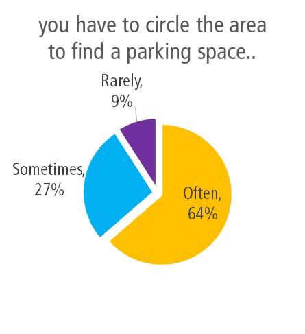
53 6.1.3 Travel to work The questionnaire survey included questions to gain an understanding of how residents got to work, and any difficulties they might face with parking issues. Residents who do not have off-street parking at their workplace within the area, generally find it difficult to park on-street. Of the 259 respondents, 20 (8%) worked within the precinct. This sample size is an accurate representation of the proportion of local workers, as suggested by the journey to work data in section 4.4, where 9% were found to work in the precinct. A majority of the residents who worked locally (13 people), did not have off street parking facilities at their workplace. Of these, only 9% find parking spaces at their workplace easily along the streets. 64% indicated that they often had to circle the area to find a parking space. This indicates the difficulties employees face in the precinct finding a parking space nearby to their place of work. 42
54 43
55 6.1.4 Parking policies The questionnaire survey included questions to gain an understanding of how residents felt about the existing parking schemes and what could be done to improve it. A summary of these responses are provided in Figure 30, with the location of these responses illustrated in Figure 31. Over 80% of respondents noted they would prefer some type of resident parking scheme. Demand for an expanded resident parking scheme was greatest at the eastern end of the corridor near Camperdown Oval and the western end near Crystal Street, the TAFE and Parramatta Road. Issues raised during the community engagement process with respect to current parking policies include: Inconsistency between the current M1 (Camperdown) and M3 (Newtown- Enmore) zones in terms of times of restrictions. This is an issue for residents at the eastern end of the Parramatta Road / Camperdown precinct which have reduced time restricted parking compared with the adjacent M3 zone. Streets within the M1 zone have time restricted parking on both sides of the street, while those in the adjacent M3 zone only have restrictions on one side of the street. There is a scattered resident parking scheme in Area M5 (Petersham) largely driven by demand from the TAFE. Residents noted that they would like to see this area widened due to parking impacts associated with the TAFE. Parking near the Fanny Durack Aquatic Centre and Petersham Oval at the western end of the precinct is a common concern. Residents of the eastern end of Station Street (opposite Petersham Oval) are entitled to a resident parking permit as they are within the M16 (Lewisham) parking area, however those at the western end of the street are not. Figure 30: Preference for a parking scheme 44
56 WENTWORTH ST ANDREAS ST STATION ST PALACE ST FORT ST CROYDON ST BRIGHTON ST QUEEN ST ELSWICK ST CRYSTAL LA W CRYSTAL ST CHARLES ST MARGARET ST WESTBOURNE ST WESTBOURNE LA CANNON ST CANNON LA PERCIVAL LA W PERCIVAL RD PERCIVAL LA E CORUNNA LA MACAULAY LA MACAULAY RD ALBANY LA BRIDGE RD CARDIGAN ST KILNER LA CARDIGAN PL CARDIGAN LA SALISBURY LA DENISON ST SALISBURY RD VICTORY LA PIDCOCK ST ETON LA AUSTRALIA ST MALLETT ST GIBBENS ST TOOTH LA HOPETOUN ST ROBERTS LA ROBERTS ST CHURCH ST NORTHWOOD ST Petersham NEW CANTERBURY ROAD Stanmore BROOKS LA km Newtown Preference for parking permits and restrictions! resident permit parking scheme! a combination of restricted and unrestricted parking! no restricted parking Parrmatta Road and Camperdown Parking Study - Figure 31

57 6.2 Public Exhibition The draft Parramatta Road corridor and Camperdown precinct parking strategy was placed on public exhibition between 5 May 2016 and 13 June The document was placed on Council s website and was visited 2,180 times. A total of 168 responses, including s, were collected from unique addresses. These responses were from residents or stakeholders, in the study area. Common issues that were raised during the public exhibition period on the draft report included: Lack of available parking for residents close to their homes. Removal of resident parking controls on certain streets, particularly Corunna Road and Margaret Street Request for extension of resident parking proposed in the strategy, particularly from residents of Fort Street (west of Railway Street) Proposal for time restricted parking on Federation Road Number of available parking permits for residents Parking for business and their visitors A map illustrating the locations of respondents, including their level of support for the strategy recommendations, is provided in Figure 32 below. Support strategy, with changes proposed Do not support strategy Supports strategy Figure 32: Location of respondents to public exhibition period 46
58 The feedback received during the public exhibition phase of the project helped inform the final strategy recommendations. Changes to the recommendations proposed in the draft strategy following the public exhibition period were as follows: Table 8: Changes to draft recommendations following document exhibition Location Draft Strategy Recommendation Final Strategy Recommendation Federation Road (south) between Australia Street and Church Street Fort Street (north) between Railway Street and Palace Street Hopetoun Street, Roberts Street and Northwood Street (western side) Bridge Road outside Bridge Road Australia Street, south of Gantry Lane Convert the existing unrestricted parking spaces to 10 hour time restricted parking, Monday to Sunday No changes to existing parking controls (unrestricted parking to be retained) Introduce time restricted parking (2P 8am-10pm Mon-Fri, M5 permit holders excepted) No changes to existing parking controls (unrestricted parking to be retained) No changes to existing parking controls (unrestricted parking to be retained) Convert the existing unrestricted parking spaces to 4 hour time restricted parking, 6pm-6am Monday to Sunday Introduce time restricted parking (2P 8am-10pm Mon-Fri, M5 permit holders excepted) As per draft recommendation - however a review should be conducted within two years of the introduction of the amended parking controls to ensure compliance has not reduced as a result of the changes. Two spaces outside Bridge Road be signposted as 1P 8:30am- 6pm (Mon-Fri) & 8:30am- 12:30pm (Sat). Implement a dedicated motorbike parking area on the western side of Australia Street, immediately south of Gantry Lane. A summary of the key issues raised during the exhibition period are summarised in the sections below. 47
 were agreeable to the proposed recommendations, although 56% of all respondents suggested further changes to the recommended measures.")
59 6.2.1 Support for Strategy Respondents were given the opportunity to provide feedback on the parking study, through a survey. A majority of the responses gathered (64%) were agreeable to the proposed recommendations, although 56% of all respondents suggested further changes to the recommended measures. 37% of respondents opposed the recommendations. Figure 33 Support for strategy Resident Parking Scheme A key issue raised in the submissions was the existing and proposed resident parking scheme. The majority of respondents were supportive of the proposed resident parking scheme, however some wanted the scheme extended to adjacent streets. In particular, a number of residents on Fort Street (west of Railway Street), Northumberland Street and Macaulay Road (west of Northumberland Street) responded noting the likely parking spillover impacts that would be generated from the draft proposals. Some residents on Macaulay Road, between Cannon Street and Northumberland Avenue, requested a RPS be introduced. Most of the respondents had small children and found difficulties parking on-street. Some residents on streets were new parking controls were proposed noted their opposition to the draft strategy, noting that current parking demand did not warrant restrictions. Locations where these responses were received included Westbourne Street and Fort Street (east of Railway Street). Some residents of Margaret Street and Corunna Road did not support the strategy to remove resident parking controls from one side of their street. They noted that the existing controls should remain on both sides of their street. 48
60 Residents of the M1 parking area were generally supportive of the changes proposed in the strategy to extend parking controls on one side of the street to seven days a week. A number of these residents requested that consistent parking controls be provided on both sides of the street, so that restrictions were in place 8am-10pm Monday through Sunday. 16 responses were received from residents of a multi-dwelling residential development on Australia Street (near Derby Place) requesting resident parking be implemented. The wording of each response was identical and appears to be a result of a notice distributed to residents in the building by the strata managers Parking Permits The allocation of parking permits was another issue raised in the public submissions. Some residents with existing on-site car parking space felt that they should also be entitled to receive a permit. A small number of submissions requested that residents be entitled to a second permit in the precinct, particularly where they are already entitled to two permits Time Restricted Parking The feedback relating to time restricted parking provided during the public exhibition period largely centred on the proposal to implement 10P restrictions on the southern side of Federation Road. Most people were generally supportive of this measure, however some residents noted that this still may not discourage people from parking overnight. Tenants of the business along Bridge Road have expressed concerns of insufficient on street car parking spaces, due to long term parking from residents and commuters Laneway Parking A number of residents commented during the public exhibition period in relation to parking in laneways. Comments typically related to residents finding it difficult to access driveways to their properties due to vehicles parked in their laneway. The following laneways within the Parramatta Road / Camperdown precinct were noted during the exhibition period: Macaulay Lane Northumberland Lane east Salisbury Lane Northumberland Lane west Motorbike Parking A number of submissions from residents of Australia Street were received requesting a designated motorbike parking area be provided near Gantry Lane. 49
61 7 Parking Management Recommendations 7.1 Overview Following community feedback and review of parking survey data, a suite of recommendations have been developed. The aim of the parking recommendations is to provide where possible an improved management system for parking for the area. The recommendations proposed takes into consideration: The current transport environment and conditions in the Parramatta Road / Camperdown precinct; Existing parking controls in neighbouring areas both in the Council area and City of Sydney Local Government Areas Feedback received during the community and stakeholder engagement process; and Results of the parking surveys conducted in the precinct 7.2 Key Principles There is a high demand for parking in sections of the Parramatta Road / Camperdown precinct due to the convenient inner city location of both residential and business areas. Based on the community consultation and parking occupancy surveys which have been undertaken for this study, it is evident that parking demand can exceed supply during the peak times. On many occasions residents have to compete with visitors and all day commuters for a suitable parking space within reasonable walking distance from their home. Typically, car parking occupancy levels greater than 85% are often considered to represent the theoretical capacity. A utilisation rate higher than 85% defines the limit of constraint in the on-street parking network. This occupancy level represents a good utilisation of car parking and provides the ability for drivers arriving to an area to find a car parking without excessive circulation. Streets where the parking utilisation was found to be 85% or greater for three or more hours of the day were considered to be of greatest significance when considering new or increased parking restrictions. In certain areas, particularly at the eastern end of the corridor and near the TAFE campus on Crystal Street, the current supply of parking is insufficient to accommodate the unconstrained peak car parking demand from all sources in the study area. However building large new carparks is very expensive, will create amenity impacts and will attract additional vehicles and traffic to the study area which is also not a desirable outcome. The only equitable way to give both residents and visitors access to parking is to place additional parking time restrictions to help manage the limited available parking capacity in the area. 50
62 It is without doubt that local businesses in the area do generate jobs and contribute significantly to the local economy in the area. It is important that the parking strategy supports the needs of small businesses especially to ensure the dynamic and eccentric character of the area is supported and promoted. Therefore the overall philosophy of the parking management must maintain an appropriate balance between the car parking needs of the residents and the businesses in the area. The optimum outcome is to ensure that all the available parking is well utilised, while still retaining some free space to facilitate parking turnover i.e. by achieving parking occupancy rates in the order of 85%. 7.3 Resident Parking Scheme Modifications to the existing resident parking scheme (RPS) is proposed for the study area. A resident parking scheme has the following advantages: It allows a more consistent approach to address parking issues It enables resident parking scheme permits to be used in the whole area so if the street where the resident lives is fully parked for any reason, there are opportunities to park in other nearby parallel streets It simplifies parking enforcement The extent of the RPS needs to be large enough to provide residents with a good opportunity to find a convenient parking space whilst not too big to encourage residents in one area to drive between land uses. The size of the area is generally dependant on the competing land uses within each zone. Areas should also be logical and ideally border on main streets. One of the disadvantages with an area wide parking scheme occurs for residential properties that are located on border of the area. A limited amount of parking permit overlap should be allowed within the border streets in future enforcement of the RPS restrictions. In order for Council to implement a residential parking permit scheme, a number of criteria are required to be met by RMS. The complete set of criteria is specified in RMS guidelines, RMS Permit Parking November The requirements must be satisfied before the issue of residential parking permits: The resident has no on-site parking or limited on-site parking and also has no unrestricted on-street parking available near their residence. The place of residence could not be reasonably modified to provide onsite parking space(s). The vehicle is not a truck, bus, tram, trailer (boats and caravans) or tractor. The number of permits to be issued for an area should not exceed the number of available on-street parking spaces in the area. Based on the community consultation and traffic engineering analysis which was undertaken for this study, Arup developed a number of recommendations relating to the existing RPS in the Parramatta Road / Camperdown study area. These recommendations are outlined in the sections below. 51
63 7.4 M1 Parking Area Recommendations Federation Road and Salisbury Road area The existing resident parking restrictions on streets in the area bounded by Salisbury Road, Federation Road, Northwood Street and Australia Street was considered for modification in this parking strategy. Most streets within this area have two hour parking restrictions between 8:30am-6pm (Monday to Friday) with permit holders of area M1 excepted on both sides of the street. Resident parking permits around this area proves to be effective during the weekdays with surveys indicating average occupancy rates in these areas ranging from 50% to 70%. However on weekends, survey data and community comments show that parking demand is high, where parking restrictions are no longer in effect. These spaces are predominantly used by visitors to the Newtown-Enmore retail / entertainment area on weekends particularly during the evening when restaurant activity is higher and events are held at the Enmore theatre. Residents have expressed concerns of parking spaces outside their residence being occupied at these times. Parking surveys indicate many of the streets within this area were at 85% occupancy (or above) on the weekend. The issue is exacerbated in this area by the proximity to the adjacent M3 (Newtown-Enmore) parking area, where controls are in place which limit parking to two hours (residents excepted) between 8am and 10pm Monday to Sunday. These same parking restrictions are in place on streets to the east in the City of Sydney Council area. Recommendation 1: Australia Street eastern side It is recommended that the time restrictions along the eastern side of Australia Street (between Federation Road and Salisbury Street) be modified 2P 8:00am- 10pm (Monday to Sunday, M1 permit holders excepted). This provides consistency with the time restrictions in the adjacent M3 parking area and provides for resident parking on weekends as well as weekdays. Recommendation 2: Hopetoun Street, Roberts Street and Northwood Street These streets have two hour parking restrictions on weekdays (M1 permit holder excepted), on both sides of the street. It is recommended that the time restrictions along the western side of these streets (between Salisbury Road and Federation Road) be modified to 2P 8:00am-10pm (Monday to Sunday, M1 permit holders excepted). This provides consistency with the time restrictions in the adjacent M3 parking area and the restrictions in place to the east on City of Sydney Council controlled streets, and provides for resident parking on weekends as well as weekdays. Implementing this modification on only one side of the street would ensure that parking would still be provided for visitors to the area on weekends wishing to stay longer than two hours. This recommendation would provide an appropriate balance for accommodating visitors to the nearby the Newtown-Enmore retail / entertainment area while also ensuring spaces are available for residents. 52
64 It is acknowledged that the revised parking arrangements, whereby different controls are in place on either side of the street, may initially lead in some confusion to those parking in the area. Therefore it is recommended that a review of the revised parking controls be undertaken no more than two years following their introduction. This review is to confirm that the changed parking controls has not resulted in a reduced level of compliance Federation Road Federation Road is located north of the Camperdown Memorial Rest Park, with M1 permit parking restrictions on the north side between Hopetoun Lane and Northwood Lane. Survey data indicated that average occupancy in permit areas were generally low, showing existing permit parking schemes in the area are effective. 81 unrestricted parking spaces can be found on the southern side of the road. Survey data and community comments show that parking demand for these spaces is high consistently above 85% throughout the day and on weekends. These spaces are predominantly used by commuters, visitors and businesses. Community feedback received for this study noted a number of vehicles utilise the southern side of Federation Road for long stay parking including trailers and campervans. This restricts available opportunities for visitors to the precinct including users of the adjacent park. Recommendation 3: Federation Road Converting the existing unrestricted parking spaces on the southern side of Federation Road (between Australia Street and Church Street) to 4 hour time restricted parking, from 6pm to 6am Monday to Sunday, is proposed in this strategy. This initiative would discourage long term parking but still ensure parking for nearby businesses and visitors is maintained. This initiative would provide more opportunities for all users to utilise these parking spaces, and also still provide sufficient time for people visiting the King Street / Enmore Road area in evenings Australia Street The western side of Australia Street is not currently subject to any parking restrictions. Survey data indicates parking demand can be high on both weekdays and weekends area. Should the 10P restriction be implemented along Federation Road south (Recommendation 3), Australia Street may experience a spill over effect for vehicles parking for extended periods of time. Recommendation 4: Australia Street western side Monitor the occupancy and turnover of the western side of Australia Street (between Lennox Street and Federation Road) following the implementing 4P parking along the south side of Federation Road as recommended in this strategy. 53
65 7.4.4 Salisbury Road The southern side of Salisbury Road between St Marys Lane and Kingston Lane is already subject to time restricted parking (M3 permit holders excepted). The north side contains 19 unrestricted parking spaces. Parking survey data indicated that average occupancy during peak hours were at 85% in M3 zone and 100% in the unrestricted areas. Community feedback also indicates that residents find difficulties finding a convenient parking space during peak hours. Recommendation 5: Salisbury Road north side Conversion of the existing 19 unrestricted spaces on the northern side of Salisbury Road (between Kingston Lane and St Mary s Street) to time restricted parking (2P 8am-10pm, M1 permit holders excepted) is recommended. Implementation of a resident parking scheme along the north side of Salisbury Street would ensure that residents can obtain a parking space where survey data indicates demand for parking is high along this street, and responds to community feedback received during this study Available Parking Permits M1 Within the existing M1 (Camperdown) area, where resident parking is provided on both sides of the street in most areas, the number of parking spaces exceeds the number of parking permits available for residents. Therefore no change is proposed to the current arrangement whereby residents are entitled to apply for up to two parking permits. 54
66 Salisbury Rd Salisbury Ln Denison St Australia St Gibbens St Salisbury Rd Kingston Ln St Mary Ln Roberts St Northwood Ln Northwood St Church St Roberts Ln Australia St Hopetoun Ln Hopetoun St Federation Rd Summary of Recommendations for M1 Area 2P 8am - 10pm Mon-Sun (M1 permit holders excepted) 4P 6pm - 6am restrictions Mon- Sun Monitor parking demand
67 7.5 M5 Parking Area Recommendations Time Restrictions for Resident Parking Currently a mix of time restrictions are provided across the precinct. Examples of existing parking restrictions within the current M5 (Petersham) area include: 1P 8:30am-6pm (Mon-Fri) and 8.30am-12.30pm (Sat) residents excepted 1P 8:30am-8pm (Mon-Fri) residents excepted 2P 8:30am-8pm (Mon-Fri) residents excepted 1P 8:30am-9pm (Mon-Fri) residents excepted 2P 8:30am-9pm (Mon-Fri) residents excepted 2P 8:30am-10pm (Mon-Fri) residents excepted Applying consistency with respect to the time periods where resident parking restrictions are in force is a key element of this parking strategy. The current inconsistency creates confusion amongst drivers and limits enforcement opportunities. Recommendation 6: Standardisation of parking restrictions within the M5 area To create consistency throughout the M5 area and reduce confusion it is recommended that the existing parking restrictions be modified to the following: 2P - 8:00am-10pm (Mon-Fri) M5 permit holders excepted These changes would apply to all streets with parking restrictions within the M5 area with the exception of Queen Street, where the existing 1 hour restrictions on weekdays and Saturdays would remain in place Margaret Street The south side of Margaret Street, west of Charles Street has seven unrestricted parking spaces and 15 parking spaces subject to one hour parking restrictions between 8:30am-8pm (Mon-Fri), with M5 permit holders excepted. Margaret Street, east of Charles Street has 33 unrestricted spaces on the north side and 25 unrestricted spaces on the south side Parking survey data indicated that average occupancy on Margaret Street in areas subject to time restricted parking were generally low, demonstrating availability of spaces for residents of the precinct. The south side of Margaret Street, west of Charles Street was found to be relatively underutilised, with an average occupancy rate of 36% on weekdays. However the 58 unrestricted spaces along Margaret Street, east of Charles Street were found to have high demands during both weekday and weekends, with occupancy rates above 85% for more than three hours observed. Residents in the area have also expressed interests in having a resident parking scheme implemented. 56
68 Recommendation 7: Margaret Street north side Conversion of the existing 33 unrestricted spaces on the northern side of Margaret Street (between Charles Street and Margaret Lane) to time restricted parking (2P 8am-10pm Mon-Fri, M5 permit holders excepted) is recommended. Implementation of a resident parking scheme along the north side of Margaret Street would ensure that residents can obtain a parking space on weekdays where survey data indicates demand for parking is high along this street, and responds to community feedback received during this study. Retaining unrestricted parking on the southern side of the street will continue to accommodate visitors to the area. Recommendation 8: Margaret Street south side Conversion of the existing 15 time restricted parking spaces on the southern side of Margaret Street (between Charles Street and Crystal Street) to unrestricted parking is recommended. Given that this section of parking is underutilised, conversion of these spaces to unrestricted parking zones would provide a more efficient utilisation of the parking spaces. This would accommodate visitors to the precinct in particular those travelling to/from the retail precinct on Parramatta Road. Existing residents would not be disadvantaged given the retention of time restrictions on the northern side of the street. Parking survey data indicates that average occupancy on the north side of Margaret Street is at 37% on weekdays, and could accommodate additional residents to park in this area. Further, Recommendation 7 provides for additional resident parking in the precinct. 57
69 7.5.3 Corunna Road Corruna Road, west of Charles Street, has time restricted parking on both sides of the road (M5 permit holders excepted). Survey data indicates parking demand is generally low in these areas, with an average occupancy of 55% on weekdays. The section of Corruna Road east of Charles Street has unrestricted parking on both sides of the street, with roughly nine resident permit parking spaces on the south side of the road. Survey data indicates parking demand on the east section of Corruna Road is low, averaging 35% on weekdays. Recommendation 9: Corunna Road, east of Charles Street Conversion of the existing 35 unrestricted spaces on the northern side of Corunna Road (between Charles Street and Cannon Street) to time restricted parking (2P 8am-10pm Mon-Fri, M5 permit holders excepted) is recommended. Implementation of a resident parking scheme along the north side of Corunna Road would ensure that residents can obtain a parking space on weekdays where survey data indicates demand for parking is high along this street, and responds to community feedback received during this study. Retaining unrestricted parking on the southern side of the street will continue to accommodate visitors to the area. Recommendation 10: Corunna Road, west of Charles Street Conversion of the existing 27 time restricted parking spaces on the southern side of Corunna Road (between Charles Street and Crystal Street) to unrestricted parking is recommended. Given that this section of parking is underutilised, conversion of these spaces to unrestricted parking zones would provide a more efficient utilisation of the parking spaces. This would accommodate visitors to the precinct in particular those travelling to/from the retail precinct on Parramatta Road. Existing residents would not be disadvantaged given the retention of time restrictions on the northern side of the street. Parking survey data indicates that average occupancy on the north side of Corunna Road is at 54% on weekdays, and could accommodate additional residents to park in this area. Further, Recommendation 9 provides for additional resident parking in the precinct Westbourne Street Westbourne Street, between Charles Street and Crystal Street, is located some 200 metres south of Petersham TAFE. The street has 42 unrestricted parking spaces on both sides of the street (84 total) and is a convenient area for TAFE students and staff to park. Westbourne Street may also be used by commuters, being just 350 metres north of Petersham railway station. Survey data shows that parking demand is high during the weekdays, with average occupancy levels after midday being 92% for both sides of the street. Recommendation 11: Westbourne Street Conversion of the 42 spaces on the northern side of Westbourne Street (between Charles Street and Crystal Street) to time restricted parking (2P 8am-10pm Mon- Fri, M5 permit holders excepted) is recommended. Implementation of a resident 58
70 parking scheme along this street responds to any spillover effects generated by the expansion of the M5 parking area to the north as recommended in this study. It would ensure that residents can obtain a parking space on weekdays where survey data indicates demand for parking is high along this street, and responds to community feedback received during this study. Retaining unrestricted parking on the southern side of the street will continue to accommodate visitors to the area including the nearby TAFE and Petersham railway station Fort Street Fort Street, between Crystal Street and Palace Street, is located adjacent to Petersham TAFE. Unrestricted parking is provided on both the northern and southern sides of the street. Survey data and community comments shows that parking demand is high during both weekdays and weekends, with average occupancy levels of 85% which is the theoretical capacity for on-street parking. The unrestricted spaces on both sides of the street is typically used by residents, TAFE students and staff as well as visitors to businesses along Parramatta Road. In the evenings parking demand is high given Fort Street s proximity to the restaurant precinct along Norton Street north of Parramatta Road. Recommendation 12: Fort Street Conversion of the 43 unrestricted spaces on the northern side of Fort Street (between Palace Street and Crystal Street) to time restricted parking (2P 8am- 10pm Mon-Fri, M5 permit holders excepted) is recommended. Implementation of a resident parking scheme along this street responds to any spillover effects generated by the expansion of the M5 parking area as recommended in this study. It would ensure that residents can obtain a parking space on weekdays where survey data indicates demand for parking is high along this street, and responds to community feedback received during this study. Retaining unrestricted parking on the southern side of the street will continue to accommodate visitors to the area including the nearby TAFE and Norton Street restaurant precinct. Further, the two hour parking limit would discourage commuters and long term stays, but still provide adequate time for TAFE students to attend classes. 59
71 7.5.6 Railway Street and Croydon Street Railway Street (between Elswick Street and Croydon Street) and Croydon Street (between Railway Street and Crystal Street) are not currently subject to any parking restrictions. Railway Street has an average parking occupancy approaching 85% on weekdays, while Croydon Street has an average parking occupancy of approximately 70% on weekdays. With the expansion of the M5 parking area as proposed in this strategy, there is the potential for spillover of parking to occur on these streets. Recommendation 13: Railway Street and Croydon Street Conversion of the 24 unrestricted spaces on the eastern side of Railway Street (between Elswick Street and Croydon Street) and the 20 spaces on the northern side of Croydon Street (between Railway Street and Crystal Street) to time restricted parking (2P 8am-10pm Mon-Fri, M5 permit holders excepted) is recommended. Implementation of a resident parking scheme along this street responds to any spillover effects generated by the expansion of the M5 parking area as recommended in this study. The proposals will ensure an equitable distribution of spaces between the residents, visitors and employees in the area. Residents should normally be able to obtain a parking space within reasonable walking distance of their home. On the other hand, many visitors and local business employees in the area will still continue to be able to park on the unrestricted side of the streets in the area Available Parking Permits M5 This strategy proposes a number of modifications to the existing RPS in the M5 (Petersham) area, including: Extension of resident parking controls to adjacent streets Amendments to the existing time restrictions to provide better consistency across the precinct; and Changes in parking controls where resident parking is currently in force on both sides of the street, providing additional unrestricted parking in these areas. Recommendation 14: Number of parking permits within M5 area Despite the above points, no change is proposed to the current arrangement whereby residents are entitled to apply for up to two parking permits. Visitor parking permits may be obtained as per the existing arrangements for resident parking areas. 60
72 Parramatta Rd Queen St Crystal St Charles St Margaret St Corunna Ln Elswick Palace St Railway St Fort St Croydon St Robert St Corunna Rd Westbourne St Westbourne Ln Albany Rd Cannon St Brighton St Summary of Draft Recommendations for M5 Area 2P 8am-10pm Mon-Fri (M5 permit holders excepted) Amend existing permit spaces to 2P 8am-10pm Mon-Fri (M5 permit holders excepted) Conversion of parking to unrestricted parking
73 7.6 Short Term Parking As previously noted, it is important that the parking strategy supports the needs of small businesses especially to ensure the dynamic and eccentric character of the area is supported and promoted. The policy to generally provide resident parking on one side of the road, with unrestricted parking on the other side, aligns with this objective. In addition to this, an area of parking along Bridge Road has been identified as suitable for providing short term parking to increased turnover of parking adjacent to businesses. The parking spaces Bridge Road (between Corunna Road and Salisbury Road) are not currently subject to any parking restrictions during daytime hours. As a result some of these spaces are occupied by all day parkers (e.g. commuters) which limits opportunities for visitors to the local businesses to the area requiring only short stay parking. Several businesses along Bridge Road do not have access to short term parking for customers. Recommendation 15: Bridge Road It is recommended that eight existing parking spaces on Bridge Road be converted to short stay parking to provide greater parking opportunities for customers of nearby businesses. The recommended spaces to be converted are as follows: Two spaces along the eastern side of Bridge Road (between Salisbury Road and the driveway entrance to the site at Bridge Road); Two spaces along the eastern side of Bridge Road (outside Bridge Road); and Four spaces along the western side of Bridge Road (between Macaulay Road and Albany Lane) It is recommended these spaces be signposted as 1P 8:30am-6pm (Mon-Fri) & 8:30am-12:30pm (Sat). The current no stopping restrictions between 9pm and 5am would remain in force for these spaces. 62
74 7.7 Future Changes to Land Uses in the Area Potential future changes in land use will impact on the demand for on-street parking within the study area. The current situation parking surveys have provided a snapshot of parking demand at the current time. It is nevertheless also important to consider how this might change in the future when determining strategic transport planning and car parking strategy objectives for the area. The future developments which are most likely to generate significant additional parking demand in the study area are: Restaurants, clubs and hotels High density residential flat buildings The Marrickville Local Environmental Plan (LEP) 2011 (in section 3.2 of this report) illustrates the current Council off-street car parking requirements for new developments, which are able to be reduced / waived in an areas such as Camperdown with good access to services and public transport. However, a major challenge in the future is how to tackle the likely increased demand for on street car parking in the area from additional residents and visitors in new residential and commercial developments if insufficient on-site parking is provided. It is understood that development applications for a number of high density residential flat developments are currently being considered by Council. In the Parramatta Road / Camperdown precinct, the potential for new high density residential development is significant given UrbanGrowth NSW s plans for future urban densification associated with their Parramatta Road urban transformation program as previously described in Section 3.4 of this report. Recommendation 16: Availability of parking permits for residents of multi-unit developments As the capacity of kerbside parking spaces is relatively fixed, to prevent new commercial and residential developments from applying further pressure on residential parking in the precinct, the current Council policy of imposing conditions of development consent limiting new multi unit development resident s access to RPS permits should be maintained. This policy is similar to the adjacent City of Sydney Council policy whereby. In the City East and City South precincts, residents of multi-unit developments approved after 8 May 1996 are not eligible to participate in the resident permit parking schemes. In the CBD precinct, residents of all developments approved after 1 May 2000 are not eligible to participate in the resident permit parking schemes. 63
75 7.8 Parking Enforcement It is essential that the recommended modifications to the current parking restrictions in the area must be accompanied by an increased level of parking enforcement. Motorists must have a perception that they are likely to be fined if they overstay parking time restrictions. Council s community traffic officers currently undertake patrols of the area as labour resources allow and demand requires. An increase in patrols in the evening hours may result in a higher compliance with parking restrictions. Any increase in evening patrols would require an increase in labour, with the cost being offset by revenue from penalty infringements. A relatively small increase in the current level of parking enforcement may be sufficient to eliminate most overstaying of parking time limits and therefore even higher levels of enforcement, such as regular patrols every day, should be unnecessary. However, it should be noted that any increase in parking enforcement in the area will require a Council commitment to meet the following additional costs: Parking officers salaries; Parking officers uniforms; Equipment purchase (vehicles, hand held device, digital cameras etc.); and Legal cost (while required). Recommendation 17: Enforcement Parking enforcement can effectively be improved by increasing patrols by Council parking officers/ rangers, particularly targeting main streets/ car parks where overstaying is highest. This measure would increase parking availability by increasing turnover. 7.9 Reducing Parking Demand It is apparent from this study that many residents in the study area are currently experiencing significant parking problems. It is also likely that residents and visitors are currently circulating local streets to find a parking space, creating unnecessary traffic congestion and associated pollution at times of peak parking demand. There are various ways to address the parking issues in the study area. Construction of a major new parking station is not considered an economically or environmentally feasible option, and encouraging of the use of sustainable transport (i.e. walking, cycling, public transport and taxi) is the best option to reduce the future parking demand. The then Marrickville Council Integrated Transport Strategy addresses various ways to reduce the future parking demand in all areas of the municipality by increased walking, public transport initiatives, bike plans, car share etc. Council is currently implementing these strategies as part of an ongoing project. 64
76 The following matters have been identified as the major current barriers to the promoting of sustainable public transport based travel patterns in the study area: Inadequate train frequency at Newtown and Petersham during weekend evenings Current availability of unrestricted parking; and Low cost of parking generally in the study area. Council will need to work with the State Government and Public Transport operators to ensure that transport services in the study area are comprehensive, interlinked and cater for the needs of both the local community and the visitors. Council will also need to ensure that alternatives to car use are well promoted and supported. For a future reliable, accessible and sustainable transport system, Council needs to: Incorporate true environmental and social costs in the transport planning (e.g. congestion, air and noise pollution); Pursue improvement of the frequency, quality and diversity of sustainable transport options (e.g. negation with Transport for NSW); Ensure that public transport is attractive and cost effective compared to driving (e.g. supported by the introduction of pay parking); Ensure that transport management is coordinated at a regional level; Ensure that the pedestrians and cyclists enjoy easy and safe access throughout the study area; Ensure that equity of available parking spaces is achieved; Ensure that effective compliance of the restricted parking spaces is reached over 75% of the time; and Ensure that access to the precinct by taxi, particularly at night, is encouraged and facilitated by pick-up and drop-off areas and taxi information. GoGet car share has been successfully operating in the area for several years (refer to Figure 36). Car sharing is a proven means of reducing the number of car journeys generated by a development. A recent study on the effectiveness of car sharing schemes across Sydney found that every car share space replaces the need for 12 private vehicle spaces 2. The then Marrickville Council introduced a car share policy in May 2014 to support car share activity within the LGA as part of its approach to supporting sustainable transport options. 2 SGS Economics & Planning (2012), Benefit-Cost Analysis of Car Share within the City of Sydney 65

77 Figure 36 GoGet parking locations Recommendation 18: Reducing parking demand Continue to lobby Transport for NSW to ensure that the best possible public transport facilities are provided for users of the precinct and continue to look for opportunities to increase the provision of car share throughout the precinct. 66
.")
78 7.10 Laneway Parking Parking in laneways was a common issue that was raised during the community consultation period of this study. It was noted parking was occurring in many laneways where there was insufficient width for vehicles to safely enter and exit off-street car parking areas (typically into private properties). Effectively managed laneways allow for adequate access while providing the maximum amount of onstreet parking. Marrickville Council has developed draft Laneway Parking Guidelines to address community concerns about accessing, using and parking in narrow laneways in the Marrickville local government area. The guidelines acknowledge that the preferable arrangement is for residents to negotiate with each other and avoid the unnecessary implementation of parking bans. Ideally, consideration of controls for individual laneways should be decided on a case by case basis for specific laneways. To establish guidelines on the required distance of restricted parking from a driveway, recommendations have been developed based on the width of the laneway. The ability to access and egress to a lane or driveway depends on the width of the access lane and the thoroughfare laneway. These parking requirements are outlined in Figure 37. Figure 37 Laneway Parking Requirements 67
City of Hermosa Beach Beach Access and Parking Study. Submitted by. 600 Wilshire Blvd., Suite 1050 Los Angeles, CA
 City of Hermosa Beach Beach Access and Parking Study Submitted by 600 Wilshire Blvd., Suite 1050 Los Angeles, CA 90017 213.261.3050 January 2015 TABLE OF CONTENTS Introduction to the Beach Access and Parking
Assessing spatial distribution and variability of destinations in inner-city Sydney from travel diary and smartphone location data
 Assessing spatial distribution and variability of destinations in inner-city Sydney from travel diary and smartphone location data Richard B. Ellison 1, Adrian B. Ellison 1 and Stephen P. Greaves 1 1 Institute
Local Area Key Issues Paper No. 13: Southern Hinterland townships growth opportunities
 Draft Sunshine Coast Planning Scheme Review of Submissions Local Area Key Issues Paper No. 13: Southern Hinterland townships growth opportunities Key Issue: Growth opportunities for Southern Hinterland
Trip Generation Model Development for Albany
 Trip Generation Model Development for Albany Hui (Clare) Yu Department for Planning and Infrastructure Email: hui.yu@dpi.wa.gov.au and Peter Lawrence Department for Planning and Infrastructure Email: lawrence.peter@dpi.wa.gov.au
Transport Planning in Large Scale Housing Developments. David Knight
 Transport Planning in Large Scale Housing Developments David Knight Large Scale Housing Developments No longer creating great urban spaces in the UK (Hall 2014) Transport Planning Transport planning processes
BROOKINGS May
 Appendix 1. Technical Methodology This study combines detailed data on transit systems, demographics, and employment to determine the accessibility of jobs via transit within and across the country s 100
Date: June 19, 2013 Meeting Date: July 5, Consideration of the City of Vancouver s Regional Context Statement
 Section E 1.5 To: From: Regional Planning and Agriculture Committee Lee-Ann Garnett, Senior Regional Planner Planning, Policy and Environment Department Date: June 19, 2013 Meeting Date: July 5, 2013 Subject:
Data Collection. Lecture Notes in Transportation Systems Engineering. Prof. Tom V. Mathew. 1 Overview 1
 Data Collection Lecture Notes in Transportation Systems Engineering Prof. Tom V. Mathew Contents 1 Overview 1 2 Survey design 2 2.1 Information needed................................. 2 2.2 Study area.....................................
I. M. Schoeman North West University, South Africa. Abstract
 Urban Transport XX 607 Land use and transportation integration within the greater area of the North West University (Potchefstroom Campus), South Africa: problems, prospects and solutions I. M. Schoeman
930 Old Northern Rd & 4 Post Office Rd, Glenorie
 Proposed Mixed Use Development 930 Old Northern & 4, Glenorie TRAFFIC AND PARKING ASSESSMENT REPORT 13 December 2016 Ref 16264 Suite 6, 20 Young Street, Neutral Bay NSW 2089 - PO Box 1868, Neutral Bay
Measuring connectivity in London
 Measuring connectivity in London OECD, Paris 30 th October 2017 Simon Cooper TfL City Planning 1 Overview TfL Connectivity measures in TfL PTALs Travel time mapping Catchment analysis WebCAT Current and
submission to plan melbourne
 submission to plan melbourne prepared by hansen partnership pty ltd december 2013 submission to plan melbourne hansen partnership pty ltd contents 1 introduction... 2 2 key issues facing melbourne...
Foreword. Vision and Strategy
 GREATER MANCHESTER SPATIAL FRAMEWORK Friends of Walkden Station Consultation Response January 2017 Foreword Friends of Walkden Station are a group of dedicated volunteers seeking to raise the status and
Typical information required from the data collection can be grouped into four categories, enumerated as below.
 Chapter 6 Data Collection 6.1 Overview The four-stage modeling, an important tool for forecasting future demand and performance of a transportation system, was developed for evaluating large-scale infrastructure
Parking Study MAIN ST
 Parking Study This parking study was initiated to help understand parking supply and parking demand within Oneida City Center. The parking study was performed and analyzed by the Madison County Planning
Trip Generation Study: A 7-Eleven Gas Station with a Convenience Store Land Use Code: 945
 Trip Generation Study: A 7-Eleven Gas Station with a Convenience Store Land Use Code: 945 Introduction The Brigham Young University Institute of Transportation Engineers student chapter (BYU ITE) completed
COUNCIL POLICY MANUAL
 COUNCIL POLICY MANUAL SECTION: PUBLIC WORKS SUBJECT: SNOW & ICE CONTROL POLICY 2012/2013 GOAL: Pages: 1 of 10 Approval Date: Dec. 3, 2012 Res. # 1001/2012 To annually identify the winter maintenance costs
NATHAN HALE HIGH SCHOOL PARKING AND TRAFFIC ANALYSIS. Table of Contents
 Parking and Traffic Analysis Seattle, WA Prepared for: URS Corporation 1501 4th Avenue, Suite 1400 Seattle, WA 98101-1616 Prepared by: Mirai Transportation Planning & Engineering 11410 NE 122nd Way, Suite
East Bay BRT. Planning for Bus Rapid Transit
 East Bay BRT Planning for Bus Rapid Transit Regional Vision Draper Prison The Bottleneck is a State-Level issue, Salt Lake County 2050 Population: 1.5M Draper Prison hopefully with some State-Level funding!
WOODRUFF ROAD CORRIDOR ORIGIN-DESTINATION ANALYSIS
 2018 WOODRUFF ROAD CORRIDOR ORIGIN-DESTINATION ANALYSIS Introduction Woodruff Road is the main road to and through the commercial area in Greenville, South Carolina. Businesses along the corridor have
Data driven approaches to Urban Planning Experience from Derry/Londonderry
 Data driven approaches to Urban Planning Experience from Derry/Londonderry Anna Rose RTPI Belfast 11 th of September 1 June 26 07:47AM 2 The value of the City The space of the city is a theatre: playing
Forecasts from the Strategy Planning Model
 Forecasts from the Strategy Planning Model Appendix A A12.1 As reported in Chapter 4, we used the Greater Manchester Strategy Planning Model (SPM) to test our long-term transport strategy. A12.2 The origins
Neighborhood Locations and Amenities
 University of Maryland School of Architecture, Planning and Preservation Fall, 2014 Neighborhood Locations and Amenities Authors: Cole Greene Jacob Johnson Maha Tariq Under the Supervision of: Dr. Chao
Attachment 3. Updating UBC s Regional Context Statement. University of British Columbia CONSIDERATION MEMORANDUM OF CONSULTATION INPUT
 Attachment 3 University of British Columbia Updating UBC s Regional Context Statement CONSIDERATION MEMORANDUM OF CONSULTATION INPUT Campus and Community Planning February 24, 2014 1 CONSIDERATION MEMORANDUM
Economic Activity Economic A ctivity
 5 Economic Economic Activity Activity ECONOMIC ACTIVITY 5.1 EMPLOYMENT... 5-7 5.1.1 OBJECTIVE... 5-7 5.1.2 POLICIES... 5-7 5.2 PROTECTING THE AREA OF EMPLOYMENT... 5-9 5.2.1 OBJECTIVE... 5-9 5.2.2 POLICIES...
CLAREMONT MASTER PLAN 2017: LAND USE COMMUNITY INPUT
 Planning and Development Department 14 North Street Claremont, New Hampshire 03743 Ph: (603) 542-7008 Fax: (603) 542-7033 Email: cityplanner@claremontnh.com www.claremontnh.com CLAREMONT MASTER PLAN 2017:
Parking Regulations Dundas Street West, from Bathurst Street to Dovercourt Road
 STAFF REPORT ACTION REQUIRED Parking Regulations Dundas Street West, from Bathurst Street to Dovercourt Road Date: October 28, 2008 To: From: Toronto and East York Community Council Director, Transportation
Regional Transit Development Plan Strategic Corridors Analysis. Employment Access and Commuting Patterns Analysis. (Draft)
") Regional Transit Development Plan Strategic Corridors Analysis Employment Access and Commuting Patterns Analysis (Draft) April 2010 Contents 1.0 INTRODUCTION... 4 1.1 Overview and Data Sources... 4 1.2
Regional Transit Development Plan Strategic Corridors Analysis Employment Access and Commuting Patterns Analysis (Draft) April 2010 Contents 1.0 INTRODUCTION... 4 1.1 Overview and Data Sources... 4 1.2
CERTIFIED RESOLUTION. introduction: and dated May 29, 2017, as attached, as appropriate
 15322 Buena Vista Avenue, White Rock BC, Canada V4B 1Y6 www.whiterockcity.ca City of White Rock P: 604.541.22121 F: 604.541.9348 /2tC% City Clerk s Office IT E ROC K June 13,2017 Stephanie Lam, Deputy
Shall we Dense?: Policy Potentials. Summary. Simon McPherson Director SJB Urban Australia au
 Shall we dense? Shall we Dense?: Policy Potentials Simon McPherson Director SJB Urban Australia smcpherson@sjb.com. au Adam Haddow Director SJB Architects Australia ahaddow@sjb.com.au Summary This paper
Speed Limit Review. Montague Road, West End. Prepared for Brisbane City Council CEB06842 CEB06842
 Speed Limit Review Montague Road, West End CEB06842 CEB06842 Prepared for Brisbane City Council 2 November 2016 Speed Limit Review Montague Road, West End Document Information Prepared for Brisbane City
Urban White Paper on Tokyo Metropolis 2002
 Urban White Paper on Tokyo Metropolis 2002 By Bureau of City Planning Tokyo Metropolitan Government Part I. "Progress in IT and City Building" Effects of computer networks on cities and cities' response
QUANTIFICATION OF THE NATURAL VARIATION IN TRAFFIC FLOW ON SELECTED NATIONAL ROADS IN SOUTH AFRICA
 QUANTIFICATION OF THE NATURAL VARIATION IN TRAFFIC FLOW ON SELECTED NATIONAL ROADS IN SOUTH AFRICA F DE JONGH and M BRUWER* AECOM, Waterside Place, Tygerwaterfront, Carl Cronje Drive, Cape Town, South
Traffic Demand Forecast
 Chapter 5 Traffic Demand Forecast One of the important objectives of traffic demand forecast in a transportation master plan study is to examine the concepts and policies in proposed plans by numerically
Trip and Parking Generation Study of Orem Fitness Center-Abstract
 Trip and Parking Generation Study of Orem Fitness Center-Abstract The Brigham Young University Institute of Transportation Engineers student chapter (BYU ITE) completed a trip and parking generation study
MULTIPLE CHOICE. Choose the one alternative that best completes the statement or answers the question.
 AP Test 13 Review Name MULTIPLE CHOICE. Choose the one alternative that best completes the statement or answers the question. 1) Compared to the United States, poor families in European cities are more
Long Term Plan What is planned for Murchison?
 Long Term Plan 2018-2028 What is planned for Murchison? 1.0 Introduction The following information provides an overview of significant projects Council has planned for the Murchison settlement in the Long
Figure 8.2a Variation of suburban character, transit access and pedestrian accessibility by TAZ label in the study area
 Figure 8.2a Variation of suburban character, transit access and pedestrian accessibility by TAZ label in the study area Figure 8.2b Variation of suburban character, commercial residential balance and mix
MEMORANDUM. The study area of the analysis was discussed with City staff and includes the following intersections:
 MEMORANDUM DATE: JULY 6, 2012 TO: FROM: RE: CC: MELANIE KNIGHT BRAD BYVELDS/ JENNIFER LUONG 1050 SOMERSET STREET PRELIMINARY TRAFFIC ANALYSIS OUR FILE NO. 111152 NEIL MALHOTRA The purpose of this memo
Project Appraisal Guidelines
 Project Appraisal Guidelines Unit 16.2 Expansion Factors for Short Period Traffic Counts August 2012 Project Appraisal Guidelines Unit 16.2 Expansion Factors for Short Period Traffic Counts Version Date
TRANSPORT MODE CHOICE AND COMMUTING TO UNIVERSITY: A MULTINOMIAL APPROACH
 TRANSPORT MODE CHOICE AND COMMUTING TO UNIVERSITY: A MULTINOMIAL APPROACH Daniele Grechi grechi.daniele@uninsubria.it Elena Maggi elena.maggi@uninsubria.it Daniele Crotti daniele.crotti@uninsubria.it SIET
Tourism. April State Planning Policy state interest guideline. Department of Infrastructure, Local Government and Planning
 Department of Infrastructure, Local Government and Planning State Planning Policy state interest guideline Tourism April 2016 Great state. Great opportunity. Preface Using this state interest guideline
CITY OF CAMBRIDGE Growth & Intensification Study Secondary Plan Stakeholder Session June 26th, 2017
 CITY OF CAMBRIDGE Growth & Intensification Study Secondary Plan Stakeholder Session June 26th, 2017 Dillon Consulting Limited Watson & Associates Economists Curtis Planning Inc. Tim Welch Consulting Inc.
Appendix B. Traffic Analysis Report
 Appendix B Traffic Analysis Report Report No. 14369/TR/WN02 August 2007 SALLINS BYPASS BYPASS OPTIONEERING ANALYSIS - TRAFFIC REPORT Kildare County Council Áras Chill Dara, Devoy Park, Naas, Co Kildare
California Urban Infill Trip Generation Study. Jim Daisa, P.E.
 California Urban Infill Trip Generation Study Jim Daisa, P.E. What We Did in the Study Develop trip generation rates for land uses in urban areas of California Establish a California urban land use trip
Regal House #CREATESOMETHING. ALL ENQUIRIES 53,647 sq.ft. RE-DEVELOPMENT OPPORTUNITY SUITABLE FOR A VARIETY OF USES OFFICE HOTEL RESIDENTIAL
 SK1 3AA #CREATESOMETHING RE-DEVELOPMENT OPPORTUNITY OFFICE HOTEL RESIDENTIAL Stockport has everything Excellent motorway access First class rail links Efficient local bus services Easy access to Manchester
CIV3703 Transport Engineering. Module 2 Transport Modelling
 CIV3703 Transport Engineering Module Transport Modelling Objectives Upon successful completion of this module you should be able to: carry out trip generation calculations using linear regression and category
HSC Geography. Year 2013 Mark Pages 10 Published Jul 4, Urban Dynamics. By James (97.9 ATAR)
") HSC Geography Year 2013 Mark 92.00 Pages 10 Published Jul 4, 2017 Urban Dynamics By James (97.9 ATAR) Powered by TCPDF (www.tcpdf.org) Your notes author, James. James achieved an ATAR of 97.9 in 2013 while
HSC Geography Year 2013 Mark 92.00 Pages 10 Published Jul 4, 2017 Urban Dynamics By James (97.9 ATAR) Powered by TCPDF (www.tcpdf.org) Your notes author, James. James achieved an ATAR of 97.9 in 2013 while
Integrated Infrastructure Planning & Spatial Mapping
 Integrated Infrastructure Planning & Spatial Mapping Presenter: Heidi Dixon, Principal Social Planner, DTPLI 23 May 2014 PART 1 PLAN MELBOURNE : Metropolitan Planning Strategy PART 2 Case Study: DTPLI
HALFF 16196? TRAFFIC MANAGEMENT PLAN. Richardson ISD Aikin Elementary School Dallas, Texas North Bowser Road Richardson, Texas 75081
 30280 16196? TRAFFIC MANAGEMENT PLAN Exhibit 572B Aikin Elementary School Planned Development District No. 572 Approved City Plan Commission October20, 2016 July 12, 2016 Prepared for HALFF AVO 31586 PHO1
VHD Daily Totals. Population 14.5% change. VMT Daily Totals Suffolk 24-hour VMT. 49.3% change. 14.4% change VMT
 6.9 Suffolk 6-54 VMT Population and Travel Characteristics Population 14.5% change 2014 1,529,202 VHD Daily Totals 2014 251,060 49.3% change 2040 1,788,175 2040 374,850 VMT Daily Totals 2014 39,731,990
NATURE AND EXTENT OF PROPOSED DEVELOPMENT. Amount of Development Development Zones Distribution of Density Policies
 NATURE AND EXTENT OF PROPOSED DEVELOPMENT Amount of Development Development Zones Distribution of Density Policies DRAFT POOLBEG PLANNING SCHEME Amount of Development 78 4.1 The rationale for the overall
Encapsulating Urban Traffic Rhythms into Road Networks
 Encapsulating Urban Traffic Rhythms into Road Networks Junjie Wang +, Dong Wei +, Kun He, Hang Gong, Pu Wang * School of Traffic and Transportation Engineering, Central South University, Changsha, Hunan,
Regional Snapshot Series: Transportation and Transit. Commuting and Places of Work in the Fraser Valley Regional District
 Regional Snapshot Series: Transportation and Transit Commuting and Places of Work in the Fraser Valley Regional District TABLE OF CONTENTS Complete Communities Daily Trips Live/Work Ratio Commuting Local
Forecasts for the Reston/Dulles Rail Corridor and Route 28 Corridor 2010 to 2050
 George Mason University Center for Regional Analysis Forecasts for the Reston/Dulles Rail Corridor and Route 28 Corridor 21 to 25 Prepared for the Fairfax County Department of Planning and Zoning Lisa
A Note on Methods. ARC Project DP The Demand for Higher Density Housing in Sydney and Melbourne Working Paper 3. City Futures Research Centre
 A Note on Methods ARC Project DP0773388 The Demand for Higher Density Housing in Sydney and Melbourne Working Paper 3 City Futures Research Centre February 2009 A NOTE ON METHODS Dr Raymond Bunker, Mr
APPENDIX IV MODELLING
 APPENDIX IV MODELLING Kingston Transportation Master Plan Final Report, July 2004 Appendix IV: Modelling i TABLE OF CONTENTS Page 1.0 INTRODUCTION... 1 2.0 OBJECTIVE... 1 3.0 URBAN TRANSPORTATION MODELLING
Council Workshop on Neighbourhoods Thursday, October 4 th, :00 to 4:00 p.m. Burlington Performing Arts Centre
 Council Workshop on Neighbourhoods Thursday, October 4 th, 2012 1:00 to 4:00 p.m. Burlington Performing Arts Centre Agenda Introductions Warm-Up Exercise Presentation Exercise Neighbourhood Planning Break
King City URA 6D Concept Plan
 King City URA 6D Concept Plan King City s Evolution Among the fastest growing cities 2000 Census 1,949 2010 Census 3,111 60% increase 2016 Census estimate 3,817 23% increase Average annual rate 4.3% Surpassing
SPACE-TIME ACCESSIBILITY MEASURES FOR EVALUATING MOBILITY-RELATED SOCIAL EXCLUSION OF THE ELDERLY
 SPACE-TIME ACCESSIBILITY MEASURES FOR EVALUATING MOBILITY-RELATED SOCIAL EXCLUSION OF THE ELDERLY Izumiyama, Hiroshi Institute of Environmental Studies, The University of Tokyo, Tokyo, Japan Email: izumiyama@ut.t.u-tokyo.ac.jp
City sustainability: a transport perspective a journey continues
 Sustainable Development, Vol. 2 833 City sustainability: a transport perspective a journey continues K. Doust1,2, C. Wang1 & T. Doust2 1 Research Centre for Integrated Transport Innovation (rciti), University
Development of modal split modeling for Chennai
 IJMTES International Journal of Modern Trends in Engineering and Science ISSN: 8- Development of modal split modeling for Chennai Mr.S.Loganayagan Dr.G.Umadevi (Department of Civil Engineering, Bannari
CVS Derwood. Local Area Transportation Review
 CVS Derwood Montgomery County, Maryland May 27, 2016 Local Area Transportation Review Prepared for: JC Bar Properties, Inc. Steve Fleming, PE 415 Fallowfield Road, Suite 301 Camp Hill, Pennsylvania 17011
The Urbana Free Library Parking and Transportation Study
 CHAMPAIGN COUNTY REGIONAL PLANNING COMMISSION The Urbana Free Library Parking and Transportation Study Final Report 7/18/2013 Champaign Urbana Urbanized Area Transportation Study (CUUATS) TABLE OF CONTENTS
Study Overview. the nassau hub study. The Nassau Hub
 Livable Communities through Sustainable Transportation the nassau hub study AlternativeS analysis / environmental impact statement The Nassau Hub Study Overview Nassau County has initiated the preparation
2. Discussion of urban railway demand change The railway traffic demand for urban area is analyzed in the population decline society in the study. In
 The traffic demand analysis for urban railway networks in population declining society Yoshiyuki Yasuda a, Hiroaki Inokuchi b, Takamasa Akiyama c a Division of Science and Engineering, Graduate school
HORIZON 2030: Land Use & Transportation November 2005
 PROJECTS Land Use An important component of the Horizon transportation planning process involved reviewing the area s comprehensive land use plans to ensure consistency between them and the longrange transportation
Appendix 2. Extracts from Ministry for the Environment Active Fault Guidelines 2003
 Extracts from Ministry for the Environment Active Fault Guidelines 2003 Published in July 2003 by the Ministry for the Environment Manatu Mo Te Taiao PO Box 10-362, Wellington, New Zealand ISBN: 0-478-18901
Growth Management: Analysis of Comments Received and Responses Comments received as of October 16, 2017
 Growth Management: Analysis of Comments Received and s Comments received as of October 16, Comments informing the Region of Peel s growth management work have been summarized with responses below. These
GIS Geographical Information Systems. GIS Management
 GIS Geographical Information Systems GIS Management Difficulties on establishing a GIS Funding GIS Determining Project Standards Data Gathering Map Development Recruiting GIS Professionals Educating Staff
The National Spatial Strategy
 Purpose of this Consultation Paper This paper seeks the views of a wide range of bodies, interests and members of the public on the issues which the National Spatial Strategy should address. These views
15 March 2010 Re: Draft Native Vegetation of the Sydney Metropolitan Catchment Management Authority Area GIS layers and explanatory reports
 SYDNEY COASTAL COUNCILS GROUP Inc. C/- City of Sydney Council Level 14, 456 Kent Street GPO Box 1591, SYDNEY NSW 2001 Phone: (02) 9246 7791 Facsimile: (02) 9265 9660 Email: info@sydneycoastalcouncils.com.au
River North Multi-Modal Transit Analysis
 River North Multi-Modal Transit Analysis November 7, 2006 Dan Meyers, AICP URS Corporation 612-373-6446 / dan_meyers@urscorp.com River North Study Area Reasons for initiating the study Downtown areas north
South Western Region Travel Time Monitoring Program Congestion Management Process Spring 2008 Report
 South Western Region Travel Monitoring Program Congestion Management Process Spring 2008 Report Prepared by: South Western Regional Planning Agency 888 Washington Boulevard Stamford, CT 06901 Telephone:
The 3V Approach. Transforming the Urban Space through Transit Oriented Development. Gerald Ollivier Transport Cluster Leader World Bank Hub Singapore
 Transforming the Urban Space through Transit Oriented Development The 3V Approach Gerald Ollivier Transport Cluster Leader World Bank Hub Singapore MDTF on Sustainable Urbanization The China-World Bank
Mapping Accessibility Over Time
 Journal of Maps, 2006, 76-87 Mapping Accessibility Over Time AHMED EL-GENEIDY and DAVID LEVINSON University of Minnesota, 500 Pillsbury Drive S.E., Minneapolis, MN 55455, USA; geneidy@umn.edu (Received
PW 001 SNOW REMOVAL AND SANDING FOR ROADWAYS AND SIDEWALKS October 6, 2014 (#223-14) Original October 19, 2015; October 15, 2018 Public Works
 Original October 19, 2015; October 15, 2018 Public Works") Policy Statement: The Village of Kitscoty will provide snow and ice control on municipal streets and sidewalks according to determined priorities. Purpose: To provide direction and information to employees
Policy Statement: The Village of Kitscoty will provide snow and ice control on municipal streets and sidewalks according to determined priorities. Purpose: To provide direction and information to employees
A tale of two cities. John Daley, CEO, Grattan Institute Work and life in cities: City strategy in Australia Melbourne Economic Forum 27 October 2016
 A tale of two cities John Daley, CEO, Grattan Institute Work and life in cities: City strategy in Australia Melbourne Economic Forum 27 October 2016 A tale of two cities Shifts in consumption are driving
Response to the Local Government Boundary Commission for England proposals for new electoral arrangements for Leeds City Council
 Response to the Local Government Boundary Commission for England proposals for new electoral arrangements for Leeds City Council This is the Leeds Liberal Democrat response to the Draft Recommendations
September Creating liveable cities in Australia A scorecard and priority recommendations for Melbourne
 September 2018 Creating liveable cities in Australia A scorecard and priority recommendations for Melbourne What makes a liveable city? The term liveability is widely used in Australia and across the world,
Economic Geography of the Long Island Region
 Geography of Data Economic Geography of the Long Island Region Copyright 2011 AFG 1 The geography of economic activity requires: - the gathering of spatial data - the location of data geographically -
Waikato District Plan. Plan Change document
 Waikato District Plan Plan Change 17 Ngaruawahia and Surrounding Villages Stage One Proposed Rezoning Plan Change document Throughout this document text OR maps referred to in the text underlined in red
Transit Time Shed Analyzing Accessibility to Employment and Services
 Transit Time Shed Analyzing Accessibility to Employment and Services presented by Ammar Naji, Liz Thompson and Abdulnaser Arafat Shimberg Center for Housing Studies at the University of Florida www.shimberg.ufl.edu
Date: March 31, 2014 PATE; fyril 2.3,2 >H
 aj BRAMPTON fifs Rower City XH-l-f r.t "»* City Council The Corporation of the City of Brampton SRAMPTON CITY COUNCIL Date: March 31, 2014 PATE; fyril 2.3,2 >H File: POO GR VisWhtoJed ^t'th-meeh'^a Subject:
National Planning Framework Louth County Council Submission
 National Planning Framework 2040 Louth County Council Submission 10 th November 2017 2 Louth County Council Introduction The primacy of the Dublin / Belfast corridor in the urban network on the island
Compiled by the Queensland Studies Authority
 Geography Annotated sample assessment Practical exercise Compiled by the February 2007 About this task This sample demonstrates several features: A practical exercise should be conducted under examination
The Governance of Land Use
 The planning system The Governance of Land Use United Kingdom Levels of government and their responsibilities The United Kingdom is a unitary state with three devolved governments in Northern Ireland,
Public Transport Versus Private Car: GIS-Based Estimation of Accessibility Applied to the Tel Aviv Metropolitan Area
 Public Transport Versus Private Car: GIS-Based Estimation of Accessibility Applied to the Tel Aviv Metropolitan Area Itzhak Benenson 1, Karel Martens 3, Yodan Rofe 2, Ariela Kwartler 1 1 Dept of Geography
Visitor Flows Model for Queensland a new approach
 Visitor Flows Model for Queensland a new approach Jason. van Paassen 1, Mark. Olsen 2 1 Parsons Brinckerhoff Australia Pty Ltd, Brisbane, QLD, Australia 2 Tourism Queensland, Brisbane, QLD, Australia 1
Accessibility analysis of multimodal transport systems using advanced GIS techniques
 Urban Transport XIII: Urban Transport and the Environment in the 21st Century 655 Accessibility analysis of multimodal transport systems using advanced GIS techniques T. Vorraa Citilabs Regional Director,
Palmerston North Area Traffic Model
 Palmerston North Area Traffic Model Presentation to IPWEA 7 November 2014 PNATM Presentation Overview Model Scope and type Data collected The model Forecasting inputs Applications PNCC Aims and Objectives
Riocan Centre Study Area Frontenac Mall Study Area Kingston Centre Study Area
 OVERVIEW the biggest challenge of the next century (Dunham Jones, 2011). New books are continually adding methods and case studies to a growing body of literature focused on tackling this massive task.
Neighbourhood Planning in Haringey. Myddleton Road Strategic Group 7 th November 2013
 Neighbourhood Planning in Haringey Myddleton Road Strategic Group 7 th November 2013 What is Neighbourhood Planning? Neighbourhood Planning, introduced through the Localism Act 2011, offers an opportunity
_INTRODUCTION TSHWANE...3 EXISTING SPATIAL FORM... 3 NATURE OF THE PROBLEM...3 STUDY AREA...5 INTRODUCTION
 CHAPTER: 1 _INTRODUCTION TSHWANE...3 EXISTING SPATIAL FORM... 3 NATURE OF THE PROBLEM...3 STUDY AREA...5 INTRODUCTION 2 TSHWANE Pretoria, the inner city region of Tshwane, a place of great significance,
Contents. Ipswich City Council Ipswich Adopted Infrastructure Charges Resolution (No. 1) Page
 Page") Ipswich City Council Ipswich Adopted Infrastructure Charges Resolution (No. 1) 2014 Contents Page Part 1 Introduction 3 1. Short title 3 2. Commencement 3 3. Sustainable Planning Act 2009 3 4. Purpose
Ipswich City Council Ipswich Adopted Infrastructure Charges Resolution (No. 1) 2014 Contents Page Part 1 Introduction 3 1. Short title 3 2. Commencement 3 3. Sustainable Planning Act 2009 3 4. Purpose
Subject: Note on spatial issues in Urban South Africa From: Alain Bertaud Date: Oct 7, A. Spatial issues
 Page 1 of 6 Subject: Note on spatial issues in Urban South Africa From: Alain Bertaud Date: Oct 7, 2009 A. Spatial issues 1. Spatial issues and the South African economy Spatial concentration of economic
GOVERNMENT MAPPING WORKSHOP RECOVER Edmonton s Urban Wellness Plan Mapping Workshop December 4, 2017
 GOVERNMENT MAPPING WORKSHOP 12.4.17 RECOVER Edmonton s Urban Wellness Plan Mapping Workshop December 4, 2017 In July of 2017, City Council directed administration to develop RECOVER, Edmonton s Urban Wellness
URBAN TRANSPORTATION SYSTEM (ASSIGNMENT)
") BRANCH : CIVIL ENGINEERING SEMESTER : 6th Assignment-1 CHAPTER-1 URBANIZATION 1. What is Urbanization? Explain by drawing Urbanization cycle. 2. What is urban agglomeration? 3. Explain Urban Class Groups.
BRANCH : CIVIL ENGINEERING SEMESTER : 6th Assignment-1 CHAPTER-1 URBANIZATION 1. What is Urbanization? Explain by drawing Urbanization cycle. 2. What is urban agglomeration? 3. Explain Urban Class Groups.
South Bristol Link Forecasting Report
 South Bristol Link April 2013 Atkins 5098941 AVTM Forecasting v2 PI (Draft 120331) Draft 31 March 2012 1 Notice This document and its contents have been prepared and are intended solely for West of England
The spatial network Streets and public spaces are the where people move, interact and transact
 The spatial network Streets and public spaces are the where people move, interact and transact The spatial network Cities are big spatial networks that create more of these opportunities Five key discoveries