Public Transport Versus Private Car: GIS-Based Estimation of Accessibility Applied to the Tel Aviv Metropolitan Area
|
|
|
- Asher Powell
- 5 years ago
- Views:
Transcription
1 Public Transport Versus Private Car: GIS-Based Estimation of Accessibility Applied to the Tel Aviv Metropolitan Area Itzhak Benenson 1, Karel Martens 3, Yodan Rofe 2, Ariela Kwartler 1 1 Dept of Geography and Human Environment, Tel Aviv University 2 J. Blaustein Institutes for Desert Research, Ben Gurion University in Negev 3 Institute for Management Research, Radboud University, Nijmegen
2 Accessibility and Equity Lack of physical access decreases the range of opportunities and is a cause of social exclusion Lack of access is primarily problem of car-less households Tool is needed to measure access levels for car-owning and car-less households to asses scope of access problem
3 What is accessibility? The extent to which land-use transport system enables individuals or goods to reach activities or destinations by means of transport modes* Given a destination: The amount of effort necessary to reach a destination Given an origin: The number of destinations/activities that can be reached from there, given the amount of effort *K.T. Geurs, J.T. Ritsema van Eck, 2001, Accessibility measures: review and applications, RIVM report , Urban Research Center, Utrecht University
4 How do we measure accessibility components? Transportation: Bases on transportation system performance (travel time, cost, effort to travel between origin and destination) Land-use: Based on distribution of activities (jobs, schools, shops) and population (workers, pupils, customers) in space and time Individual, utility-based: Based on needs and benefits people derive from the access to facilities
5 Gravitation model and its generalization are yet most popular Accessibility of activity J (jobs) from location i A = n j= 1 J j d ij β β J j d ij - Distance decay rate - Activities (jobs) at j - Distance between i and j Numerous generalizations combine different dimensions of the problem into one index and, thus, are problematic Weibull (1976) A i P i O j D j F( d ij ) - Job potential at i - Population potential at i - Population at j - Jobs at j - Distance decay function
?")
6 Transportation component is the one commonly accepted (and very practical) How many people can reach the given location by train (for a given amount of effort)? Example of transport accessibility
? Example of transport accessibility")
7 How many activities can be reached from the given origin (for a given amount of effort)? Example of transport accessibility
8 We estimated the transport component of accessibility in Tel Aviv metropolitan area


9 Street network Attributes: traffic directions, speed Sufficient to measure accessibility by car


10 Bus lines Bus stops Relation between bus lines and stops. Necessary component for measuring bus accessibility

11 Bus time-table Necessary for measuring bus accessibility


12 Urban land-uses Land-uses No of jobs by traffic zones Necessary for measuring activity component of accessibility


13 Car ownership Population numbers by traffic zones Socio-economic level Socio-economic level by traffic zones Sufficient to measure demand for bus accessibility
14 Exact definition of transport accessibility Bus Travel Time (BTT): BTT = Walk time from origin to a stop of Bus 1 + Waiting time of Bus 1 + Travel time of Bus 1 + [Transfer walk time to Bus 2 + Waiting time of Bus 2 + Travel time of Bus 2] + + Walk time from the final stop to destination Car Travel Time (CTT): CTT = Walk time from origin to the parking place + Car trip time + Parking search time + Walk time from the final parking place to destination. Service area: Given origin O, transportation mode M and travel time τ define Mode Service Area - MSA O (τ) - as minimal area containing all destinations D that can be reached from O with M during MTT τ. Access area: Given destination D, transportation mode M and travel time τ define Mode Access Area MSA D (τ) - as minimal area containing all origins O from which given destination D can be reached during MTT τ. We thus distinguish between Bus Service Area BSA O (τ), Bus Access Area BAA O (τ), Car Service Area CSA O (τ), Car Access Area CAA O (τ)
15 We focus on measuring relative accessibility (i.e. ratio between areas of service/access by public transport and car) Service areas ratio: SA O (τ) = BSA O (τ)/csa O (τ) Access area ratio: AA D (τ) = BAA D (τ)/caa D (τ)

16 Urban.Access application

17 Urban.Access parameters Day of the week Trip start/finish time Max time of waiting at initial stop Walk speed when changing lines Max travel time Calculate access area Max number of line changes Calculate service area

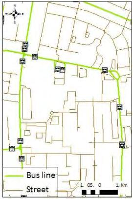
18 Stops one can reach during τ service/access area
19 Area accessibility urban land-uses accessibility


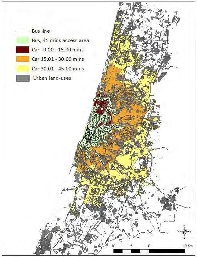
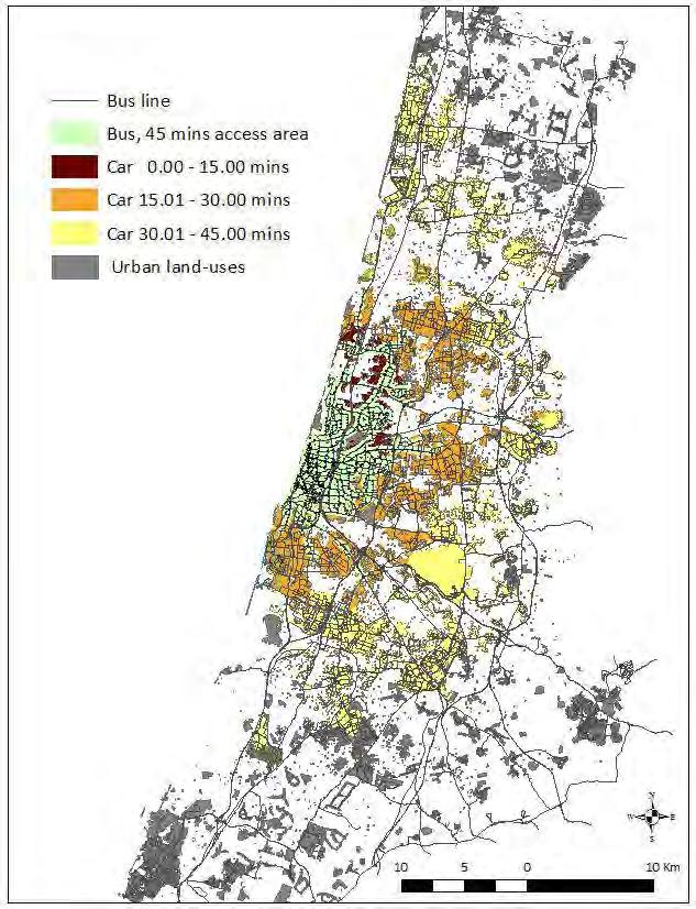
20 Accessibility maps for Tel-Aviv metropolitan Relative accessibility decreases twice the metropolitan center to periphery! (One of the major goals of the transit system is to connect between the center and periphery )
21 Access Area indices (AA D,Employment (τ) indices), for employment destinations in Tel-Aviv metropolitan, 7:00h versus 12:00h In Tel Aviv metropolitan With the car you can reach four times more jobs than with the bus With the direct bus you reach 10 time less jobs than with the car Areas essentially differ in relative accessibility

22 Accessibility gaps in Tel-Aviv metropolitan There are areas within the city with very low accessibility. These areas emerge because nobody thinks about accessibility when managing bus network. The only criteria of a bus companies is the number of passengers in a bus, to make the line profitable. In addition, the demands of the bus-drivers trade-union makes the system extremely conservative.

23 Main reason of low relative accessibility: low frequency of buses The analysis of the results clearly manifests that the main reason of the low relative accessibility is a long waiting time, both at the start and at the transition stops What might be the reasons for transportation planners to preserve this ineffective time-table?
24 Bus company: Increase intervals between departures, for full exploiting bus capacity Passenger: Less certain bus arrivals, especially during peak hours reduced relative accessibility Vicious loop of public transportation systems dynamics Passenger: Further avoid use of buses if they have choice Bus company: Vague timetable at stops aimed at preventing complaints High frequency of all lines, provides high accessibility, serves all population groups (Curitiba) Should be established at once, otherwise costly and highly vulnerable during transition period One-way evolution of the transportation system Adaptive frequency of lines, provides average accessibility, serves non car-owners only (Tel Aviv) Robust, self-regulating, preserves reasonable level of profit
25 Thank you!
Leaving the Ivory Tower of a System Theory: From Geosimulation of Parking Search to Urban Parking Policy-Making
 Leaving the Ivory Tower of a System Theory: From Geosimulation of Parking Search to Urban Parking Policy-Making Itzhak Benenson 1, Nadav Levy 1, Karel Martens 2 1 Department of Geography and Human Environment,
Accessibility: an academic perspective
 Accessibility: an academic perspective Karst Geurs, Associate Professor, Centre for Transport Studies, University of Twente, the Netherlands 28-2-2011 Presentatietitel: aanpassen via Beeld, Koptekst en
CIV3703 Transport Engineering. Module 2 Transport Modelling
 CIV3703 Transport Engineering Module Transport Modelling Objectives Upon successful completion of this module you should be able to: carry out trip generation calculations using linear regression and category
Lecture 19: Common property resources
 Lecture 19: Common property resources Economics 336 Economics 336 (Toronto) Lecture 19: Common property resources 1 / 19 Introduction Common property resource: A resource for which no agent has full property
Mapping Accessibility Over Time
 Journal of Maps, 2006, 76-87 Mapping Accessibility Over Time AHMED EL-GENEIDY and DAVID LEVINSON University of Minnesota, 500 Pillsbury Drive S.E., Minneapolis, MN 55455, USA; geneidy@umn.edu (Received
GIS Analysis of Crenshaw/LAX Line
 PDD 631 Geographic Information Systems for Public Policy, Planning & Development GIS Analysis of Crenshaw/LAX Line Biying Zhao 6679361256 Professor Barry Waite and Bonnie Shrewsbury May 12 th, 2015 Introduction
Typical information required from the data collection can be grouped into four categories, enumerated as below.
 Chapter 6 Data Collection 6.1 Overview The four-stage modeling, an important tool for forecasting future demand and performance of a transportation system, was developed for evaluating large-scale infrastructure
The 3V Approach. Transforming the Urban Space through Transit Oriented Development. Gerald Ollivier Transport Cluster Leader World Bank Hub Singapore
 Transforming the Urban Space through Transit Oriented Development The 3V Approach Gerald Ollivier Transport Cluster Leader World Bank Hub Singapore MDTF on Sustainable Urbanization The China-World Bank
Assessing the Employment Agglomeration and Social Accessibility Impacts of High Speed Rail in Eastern Australia: Sydney-Canberra-Melbourne Corridor
 Assessing the Employment Agglomeration and Social Accessibility Impacts of High Speed Rail in Eastern Australia: Sydney-Canberra-Melbourne Corridor Professor David A. Hensher FASSA Founding Director Institute
Transit Time Shed Analyzing Accessibility to Employment and Services
 Transit Time Shed Analyzing Accessibility to Employment and Services presented by Ammar Naji, Liz Thompson and Abdulnaser Arafat Shimberg Center for Housing Studies at the University of Florida www.shimberg.ufl.edu
Data Collection. Lecture Notes in Transportation Systems Engineering. Prof. Tom V. Mathew. 1 Overview 1
 Data Collection Lecture Notes in Transportation Systems Engineering Prof. Tom V. Mathew Contents 1 Overview 1 2 Survey design 2 2.1 Information needed................................. 2 2.2 Study area.....................................
Assessing spatial distribution and variability of destinations in inner-city Sydney from travel diary and smartphone location data
 Assessing spatial distribution and variability of destinations in inner-city Sydney from travel diary and smartphone location data Richard B. Ellison 1, Adrian B. Ellison 1 and Stephen P. Greaves 1 1 Institute
True Smart and Green City? 8th Conference of the International Forum on Urbanism
 ,, doi:10.3390/ifou-. True Smart and Green City? 8th Conference of the International Forum on Urbanism Conference Proceedings Paper Comparable Measures of Accessibility to Public Transport by the General
Analysis and Design of Urban Transportation Network for Pyi Gyi Ta Gon Township PHOO PWINT ZAN 1, DR. NILAR AYE 2
 www.semargroup.org, www.ijsetr.com ISSN 2319-8885 Vol.03,Issue.10 May-2014, Pages:2058-2063 Analysis and Design of Urban Transportation Network for Pyi Gyi Ta Gon Township PHOO PWINT ZAN 1, DR. NILAR AYE
From transport to accessibility: the new lease of life of an old concept
 Paris 07 /01/ 2015 From transport to accessibility: the new lease of life of an old concept Pr. Yves Crozet Laboratory of Transport Economics (LET) University of Lyon (IEP) - France yves.crozet@let.ish-lyon.cnrs.fr
BROOKINGS May
 Appendix 1. Technical Methodology This study combines detailed data on transit systems, demographics, and employment to determine the accessibility of jobs via transit within and across the country s 100
Measuring connectivity in London
 Measuring connectivity in London OECD, Paris 30 th October 2017 Simon Cooper TfL City Planning 1 Overview TfL Connectivity measures in TfL PTALs Travel time mapping Catchment analysis WebCAT Current and
Forecasts from the Strategy Planning Model
 Forecasts from the Strategy Planning Model Appendix A A12.1 As reported in Chapter 4, we used the Greater Manchester Strategy Planning Model (SPM) to test our long-term transport strategy. A12.2 The origins
SPACE-TIME ACCESSIBILITY MEASURES FOR EVALUATING MOBILITY-RELATED SOCIAL EXCLUSION OF THE ELDERLY
 SPACE-TIME ACCESSIBILITY MEASURES FOR EVALUATING MOBILITY-RELATED SOCIAL EXCLUSION OF THE ELDERLY Izumiyama, Hiroshi Institute of Environmental Studies, The University of Tokyo, Tokyo, Japan Email: izumiyama@ut.t.u-tokyo.ac.jp
Traffic Demand Forecast
 Chapter 5 Traffic Demand Forecast One of the important objectives of traffic demand forecast in a transportation master plan study is to examine the concepts and policies in proposed plans by numerically
Employment Decentralization and Commuting in U.S. Metropolitan Areas. Symposium on the Work of Leon Moses
 Employment Decentralization and Commuting in U.S. Metropolitan Areas Alex Anas Professor of Economics University at Buffalo Symposium on the Work of Leon Moses February 7, 2014 9:30-11:15am, and 2:30-4:30pm
Accessibility: introduction, perspectives and applications. Prof. dr. Karst Geurs Center for Transport Studies, University of Twente, the Netherlands
 Accessibility: introduction, perspectives and applications Prof. dr. Karst Geurs Center for Transport Studies, University of Twente, the Netherlands Contents 1. Different perspectives to measuring accessibility
The Spatial Structure of Cities: International Examples of the Interaction of Government, Topography and Markets
 Module 2: Spatial Analysis and Urban Land Planning The Spatial Structure of Cities: International Examples of the Interaction of Government, Topography and Markets Alain Bertaud Urbanist Summary What are
A Micro-Analysis of Accessibility and Travel Behavior of a Small Sized Indian City: A Case Study of Agartala
 A Micro-Analysis of Accessibility and Travel Behavior of a Small Sized Indian City: A Case Study of Agartala Moumita Saha #1, ParthaPratim Sarkar #2,Joyanta Pal #3 #1 Ex-Post graduate student, Department
Estimating Transportation Demand, Part 2
 Transportation Decision-making Principles of Project Evaluation and Programming Estimating Transportation Demand, Part 2 K. C. Sinha and S. Labi Purdue University School of Civil Engineering 1 Estimating
The sustainable location of low-income housing development in South African urban areas
 Sustainable Development and Planning II, Vol. 2 1165 The sustainable location of low-income housing development in South African urban areas S. Biermann CSIR Building and Construction Technology Abstract
STILLORGAN QBC LEVEL OF SERVICE ANALYSIS
 4-5th September, STILLORGAN QBC LEVEL OF SERVICE ANALYSIS Mr David O Connor Lecturer Dublin Institute of Technology Mr Philip Kavanagh Graduate Planner Dublin Institute of Technology Abstract Previous
Research Article GEOGRAPHIC INFORMATION SYSTEM (GIS) BASED ACCESSIBILITY ANALYSIS FOR HIGHWAY TRANSPORTATION
 BASED ACCESSIBILITY ANALYSIS FOR HIGHWAY TRANSPORTATION") Sigma J Eng & Nat Sci 8 (4), 2017, 339-344 Publications Prepared for Transist 2016, 9th International İstanbul Transport Congress Research Article GEOGRAPHIC INFORMATION SYSTEM (GIS) BASED ACCESSIBILITY
Sigma J Eng & Nat Sci 8 (4), 2017, 339-344 Publications Prepared for Transist 2016, 9th International İstanbul Transport Congress Research Article GEOGRAPHIC INFORMATION SYSTEM (GIS) BASED ACCESSIBILITY
Note on Transportation and Urban Spatial Structure
 Note on Transportation and Urban Spatial Structure 1 By Alain Bertaud, Washington, ABCDE conference, April 2002 Email: duatreb@msn.com Web site: http://alain-bertaud.com/ http://alainbertaud.com/ The physical
Development of modal split modeling for Chennai
 IJMTES International Journal of Modern Trends in Engineering and Science ISSN: 8- Development of modal split modeling for Chennai Mr.S.Loganayagan Dr.G.Umadevi (Department of Civil Engineering, Bannari
TRANSPORTATION MODELING
 TRANSPORTATION MODELING Modeling Concept Model Tools and media to reflect and simple a measured reality. Types of Model Physical Model Map and Chart Model Statistics and mathematical Models MODEL? Physical
Figure 8.2a Variation of suburban character, transit access and pedestrian accessibility by TAZ label in the study area
 Figure 8.2a Variation of suburban character, transit access and pedestrian accessibility by TAZ label in the study area Figure 8.2b Variation of suburban character, commercial residential balance and mix
Speakers: Jeff Price, Federal Transit Administration Linda Young, Center for Neighborhood Technology Sofia Becker, Center for Neighborhood Technology
 Speakers: Jeff Price, Federal Transit Administration Linda Young, Center for Neighborhood Technology Sofia Becker, Center for Neighborhood Technology Peter Haas, Center for Neighborhood Technology Craig
Travel behavior of low-income residents: Studying two contrasting locations in the city of Chennai, India
 Travel behavior of low-income residents: Studying two contrasting locations in the city of Chennai, India Sumeeta Srinivasan Peter Rogers TRB Annual Meet, Washington D.C. January 2003 Environmental Systems,
Leveraging Urban Mobility Strategies to Improve Accessibility and Productivity of Cities
 Leveraging Urban Mobility Strategies to Improve Accessibility and Productivity of Cities Aiga Stokenberga World Bank GPSC African Regional Workshop May 15, 2018 Roadmap 1. Africa s urbanization and its
Knowledge claims in planning documents on land use and transport infrastructure impacts
 Knowledge claims in planning documents on land use and transport infrastructure impacts Presentation at the Final Workshop of the research project "Innovations for sustainable public transport in Nordic
Policy Note 6. Measuring Unemployment by Location and Transport: StepSA s Access Envelope Technologies
 6 Measuring Unemployment by Location and Transport: StepSA s Access Envelope Technologies Introduction Increasing emphasis is coming onto spatial planning as government in South Africa moves to address
Indicator : Proportion of population that has convenient access to public transport, by sex, age and persons with disabilities
 Goal 11: Make cities and human settlements inclusive, safe, resilient and sustainable Target 11.2: By 2030, provide access to safe, affordable, accessible and sustainable transport systems for all, improving
Subject: Note on spatial issues in Urban South Africa From: Alain Bertaud Date: Oct 7, A. Spatial issues
 Page 1 of 6 Subject: Note on spatial issues in Urban South Africa From: Alain Bertaud Date: Oct 7, 2009 A. Spatial issues 1. Spatial issues and the South African economy Spatial concentration of economic
Dr.Sinisa Vukicevic Dr. Robert Summers
 Dr.Sinisa Vukicevic Dr. Robert Summers "Planning" means the scientific, aesthetic, and orderly disposition of land, resources, facilities and services with a view to securing the physical, economic and
OPTIMISING SETTLEMENT LOCATIONS: LAND-USE/TRANSPORT MODELLING IN CAPE TOWN
 OPTIMISING SETTLEMENT LOCATIONS: LAND-USE/TRANSPORT MODELLING IN CAPE TOWN Molai, L. and Vanderschuren, M.J.W.A. Civil Engineering, Faculty of Engineering and the Built Environment, University of Cape
FHWA Planning Data Resources: Census Data Planning Products (CTPP) HEPGIS Interactive Mapping Portal
 HEPGIS Interactive Mapping Portal") FHWA Planning Data Resources: Census Data Planning Products (CTPP) HEPGIS Interactive Mapping Portal Jeremy Raw, P.E. FHWA, Office of Planning, Systems Planning and Analysis August 2017 Outline Census
FHWA Planning Data Resources: Census Data Planning Products (CTPP) HEPGIS Interactive Mapping Portal Jeremy Raw, P.E. FHWA, Office of Planning, Systems Planning and Analysis August 2017 Outline Census
Accessibility analysis of multimodal transport systems using advanced GIS techniques
 Urban Transport XIII: Urban Transport and the Environment in the 21st Century 655 Accessibility analysis of multimodal transport systems using advanced GIS techniques T. Vorraa Citilabs Regional Director,
Commuting, public transport investments and gentrification
 Commuting, public transport investments and gentrification Evidence from Copenhagen Ismir Mulalic Technical University of Denmark and Kraks Fond June 12, 2018 Ismir Mulalic (DTU and Kraks Fond) Commuting
Joint-accessibility Design (JAD) Thomas Straatemeier
 Thomas Straatemeier") Joint-accessibility Design (JAD) Thomas Straatemeier To cite this report: Thomas Straatemeier (2012) Joint-accessibility Design (JAD), in Angela Hull, Cecília Silva and Luca Bertolini (Eds.) Accessibility
Joint-accessibility Design (JAD) Thomas Straatemeier To cite this report: Thomas Straatemeier (2012) Joint-accessibility Design (JAD), in Angela Hull, Cecília Silva and Luca Bertolini (Eds.) Accessibility
Economic and Social Urban Indicators: A Spatial Decision Support System for Chicago Area Transportation Planning
 Economic and Social Urban Indicators: A Spatial Decision Support System for Chicago Area Transportation Planning Piyushimita Thakuriah (Vonu), P.S. Sriraj, Paul Metaxatos, Inshu Minocha & Tanushri Swarup
PRIMA. Planning for Retailing in Metropolitan Areas
 PRIMA Planning for Retailing in Metropolitan Areas Metropolitan Dimension to sustainable retailing futures Metropolitan strategies Retailing in city and town centres will be a primary component of any
MULTIPLE CHOICE. Choose the one alternative that best completes the statement or answers the question.
 AP Test 13 Review Name MULTIPLE CHOICE. Choose the one alternative that best completes the statement or answers the question. 1) Compared to the United States, poor families in European cities are more
Developing Built Environment Indicators for Urban Oregon. Dan Rubado, MPH EPHT Epidemiologist Oregon Public Health Division
 Developing Built Environment Indicators for Urban Oregon Dan Rubado, MPH EPHT Epidemiologist Oregon Public Health Division What is the built environment? The built environment encompasses spaces and places
ACCESSIBILITY AND EQUITY THE CASE OF SANTIAGO, CHILE. Ignacio Tiznado Ricardo Hurtubia Juan Carlos Muñoz
 ACCESSIBILITY AND EQUITY THE CASE OF SANTIAGO, CHILE Ignacio Tiznado Ricardo Hurtubia Juan Carlos Muñoz Outline Santiago, Chile Urban segregation and income inequality Accessibility to opportunities: evolution
When GIS meets LUTI: Enhanced version of the MARS simulation model through local accessibility coefficients
 When GIS meets LUTI: Enhanced version of the MARS simulation model through local accessibility coefficients M. H. Salas-Olmedo, Y. Wang, A. Alonso, A. Monzón, J.C. García-Palomares tgis Transport, Infrastructure
A Simplified Travel Demand Modeling Framework: in the Context of a Developing Country City
 A Simplified Travel Demand Modeling Framework: in the Context of a Developing Country City Samiul Hasan Ph.D. student, Department of Civil and Environmental Engineering, Massachusetts Institute of Technology,
Influence of Guangzhou Metro Line 6 on Transit Accessibility in Xunfengzhou District, Guangzhou
 International Journal of Emerging Engineering Research and Technology Volume 4, Issue 9, September 2016, PP 26-36 ISSN 2349-4395 (Print) & ISSN 2349-4409 (Online) Influence of Guangzhou Metro Line 6 on
MANAGING TRANSPORTATION & LAND USE INTERACTIONS (PL-58)
") MANAGING TRANSPORTATION & LAND USE INTERACTIONS (PL-58) COURSE OUTLINE DAY ONE 1:30 2:00 p.m. MODULE 1: History and Context Understand history and foundation for transportation and land use planning today
MANAGING TRANSPORTATION & LAND USE INTERACTIONS (PL-58) COURSE OUTLINE DAY ONE 1:30 2:00 p.m. MODULE 1: History and Context Understand history and foundation for transportation and land use planning today
A MULTI-MODAL APPROACH TO SUSTAINABLE ACCESSIBILITY: A CASE STUDY FOR THE CITY OF GALWAY, IRELAND
 A MULTI-MODAL APPROACH TO SUSTAINABLE ACCESSIBILITY: A CASE STUDY FOR THE CITY OF GALWAY, IRELAND Dr. Amaya Vega Post-Doctoral Researcher School of Business and Economics, National University of Ireland
ROUNDTABLE ON SOCIAL IMPACTS OF TIME AND SPACE-BASED ROAD PRICING Luis Martinez (with Olga Petrik, Francisco Furtado and Jari Kaupilla)
") ROUNDTABLE ON SOCIAL IMPACTS OF TIME AND SPACE-BASED ROAD PRICING Luis Martinez (with Olga Petrik, Francisco Furtado and Jari Kaupilla) AUCKLAND, NOVEMBER, 2017 Objective and approach (I) Create a detailed
ROUNDTABLE ON SOCIAL IMPACTS OF TIME AND SPACE-BASED ROAD PRICING Luis Martinez (with Olga Petrik, Francisco Furtado and Jari Kaupilla) AUCKLAND, NOVEMBER, 2017 Objective and approach (I) Create a detailed
Opportunity-Based Dynamic Transit Accessibility in Southern California
 Opportunity-Based Dynamic Transit Accessibility in Southern California Measurement, Findings, and Comparison with Automobile Accessibility Ting L. Lei, Yali Chen, and Konstadinos G. Goulias Accessibility
Financing Urban Transport. UNESCAP-SUTI Event
 Financing Urban Transport UNESCAP-SUTI Event October 2017 Urban Transport in Context 2 The spiky urban economy of global cities 3 Mass transit networks converge towards a characteristic structure with
Effects of a non-motorized transport infrastructure development in the Bucharest metropolitan area
 The Sustainable City IV: Urban Regeneration and Sustainability 589 Effects of a non-motorized transport infrastructure development in the Bucharest metropolitan area M. Popa, S. Raicu, D. Costescu & F.
INSTITUTE OF POLICY AND PLANNING SCIENCES. Discussion Paper Series
 INSTITUTE OF POLICY AND PLANNING SCIENCES Discussion Paper Series No. 1102 Modeling with GIS: OD Commuting Times by Car and Public Transit in Tokyo by Mizuki Kawabata, Akiko Takahashi December, 2004 UNIVERSITY
Instituto Superior Técnico Masters in Civil Engineering. Theme 3: Transport networks and external costs. Transport land-use interaction
 Instituto Superior Técnico Masters in Civil Engineering REGIÕES E REDES () Theme 3: Transport land-use interaction Prof. Filipe Moura 1 OUTLINE Transport networks, external costs and market failures Transport
MOR CO Analysis of future residential and mobility costs for private households in Munich Region
 MOR CO Analysis of future residential and mobility costs for private households in Munich Region The amount of the household budget spent on mobility is rising dramatically. While residential costs can
Commuter s Modal Choice: A Case Study of Savar Pourashava
 Journal of Bangladesh Institute of Planners ISSN 2075-9363 Vol. 2, December 2009, pp. 78-97, Bangladesh Institute of Planners Commuter s Modal Choice: A Case Study of Savar Pourashava Md. Lutfur Rahman
CIE4801 Transportation and spatial modelling Modal split
 CIE4801 Transportation and spatial modelling Modal split Rob van Nes, Transport & Planning 31-08-18 Delft University of Technology Challenge the future Content Nested logit part 2 Modelling component 3:
The Model Research of Urban Land Planning and Traffic Integration. Lang Wang
 International Conference on Materials, Environmental and Biological Engineering (MEBE 2015) The Model Research of Urban Land Planning and Traffic Integration Lang Wang Zhejiang Gongshang University, Hangzhou
Trip Generation Model Development for Albany
 Trip Generation Model Development for Albany Hui (Clare) Yu Department for Planning and Infrastructure Email: hui.yu@dpi.wa.gov.au and Peter Lawrence Department for Planning and Infrastructure Email: lawrence.peter@dpi.wa.gov.au
MOBILITIES AND LONG TERM LOCATION CHOICES IN BELGIUM MOBLOC
 MOBILITIES AND LONG TERM LOCATION CHOICES IN BELGIUM MOBLOC A. BAHRI, T. EGGERICKX, S. CARPENTIER, S. KLEIN, PH. GERBER X. PAULY, F. WALLE, PH. TOINT, E. CORNELIS SCIENCE FOR A SUSTAINABLE DEVELOPMENT
KEY QUESTIONS KEY IDEAS SPECIFICATION CONTENT. Extreme environments are susceptible to environmental damage from the development of tourism.
 EXAM SPECIFIATION KEY QUESTIONS KEY IDEAS SPECIFICATION CONTENT AQA GCSE GEOGRAPHY A Unit 2: Human Geography Section B What is an extreme environment? What attracts tourists to Extreme environments? Extreme
THE FUTURE OF FORECASTING AT METROPOLITAN COUNCIL. CTS Research Conference May 23, 2012
 THE FUTURE OF FORECASTING AT METROPOLITAN COUNCIL CTS Research Conference May 23, 2012 Metropolitan Council forecasts Regional planning agency and MPO for Twin Cities metropolitan area Operates regional
Alluvium Consulting Australia Senior integrated water management specialist Position Description March 2018
 Alluvium Consulting Australia Senior integrated water management specialist Position Description March 2018 Overview of Alluvium We are an employee-owned consulting firm founded in 2006 to provide advice
Accessibility as an Instrument in Planning Practice. Derek Halden DHC 2 Dean Path, Edinburgh EH4 3BA
 Accessibility as an Instrument in Planning Practice Derek Halden DHC 2 Dean Path, Edinburgh EH4 3BA derek.halden@dhc1.co.uk www.dhc1.co.uk Theory to practice a starting point Shared goals for access to
Environment and Planning B: Planning and Design 2003, volume 30, pages 69 ^ 87
 Environment and Planning B: Planning and Design 2003, volume 30, pages 69 ^ 87 DOI:10.1068/b12940 Evaluation of accessibility impacts of land-use scenarios: the implications of job competition, land-use,
Towards an International Data Set for MST
 Towards an International Data Set for MST Carl Obst, UNWTO Consultant 15 October, 2018 Background and context The key role of the Measuring the Sustainability of Tourism (MST) project is to support more
A control strategy to prevent propagating delays in high-frequency railway systems
 A control strategy to prevent propagating delays in high-frequency railway systems Kentaro Wada* Graduate School of Information Sciences, Tohoku University, Sendai, Miyagi, Japan Takashi Akamatsu Graduate
Opportunities and challenges of HCMC in the process of development
 Opportunities and challenges of HCMC in the process of development Lê Văn Thành HIDS HCMC, Sept. 16-17, 2009 Contents The city starting point Achievement and difficulties Development perspective and goals
A/Prof. Mark Zuidgeest ACCESSIBILITY EFFECTS OF RELOCATION AND HOUSING PROJECT FOR THE URBAN POOR IN AHMEDABAD, INDIA
 A/Prof. Mark Zuidgeest ACCESSIBILITY EFFECTS OF RELOCATION AND HOUSING PROJECT FOR THE URBAN POOR IN AHMEDABAD, INDIA South African Cities Network/University of Pretoria, 09 April 2018 MOBILITY Ability
A TRANSIT ACCESS ANALYSIS OF TANF RECIPIENTS IN THE CITY OF PORTLAND, OREGON
 A TRANSIT ACCESS ANALYSIS OF TANF RECIPIENTS IN THE CITY OF PORTLAND, OREGON By Thomas W. Sanchez Center for Urban Studies Portland State University ABSTRACT Little evidence exists regarding the relationship
Managing Growth: Integrating Land Use & Transportation Planning
 Managing Growth: Integrating Land Use & Transportation Planning Metro Vancouver Sustainability Community Breakfast Andrew Curran Manager, Strategy June 12, 2013 2 Integrating Land Use & Transportation
2. Discussion of urban railway demand change The railway traffic demand for urban area is analyzed in the population decline society in the study. In
 The traffic demand analysis for urban railway networks in population declining society Yoshiyuki Yasuda a, Hiroaki Inokuchi b, Takamasa Akiyama c a Division of Science and Engineering, Graduate school
Urban Planning Word Search Level 1
 Urban Planning Word Search Level 1 B C P U E C O S Y S T E M P A R E U O E U R B A N P L A N N E R T N S T D H E C O U N T Y G E R E R D W R E N I C I T Y C O U N C I L A A A S U G G C I L A G P R I R
ACCESSIBILITY TO SERVICES IN REGIONS AND CITIES: MEASURES AND POLICIES NOTE FOR THE WPTI WORKSHOP, 18 JUNE 2013
 ACCESSIBILITY TO SERVICES IN REGIONS AND CITIES: MEASURES AND POLICIES NOTE FOR THE WPTI WORKSHOP, 18 JUNE 2013 1. Significant differences in the access to basic and advanced services, such as transport,
East Bay BRT. Planning for Bus Rapid Transit
 East Bay BRT Planning for Bus Rapid Transit Regional Vision Draper Prison The Bottleneck is a State-Level issue, Salt Lake County 2050 Population: 1.5M Draper Prison hopefully with some State-Level funding!
Mapping cities by transit riders trajectories: The case of Brisbane, Australia. Citation Environment and Planning A, 2017, v. 49 n. 8, p.
 Title Mapping cities by transit riders trajectories: The case of Brisbane, Australia Author(s) Zhou, J; Corcoran, J; Borsellino, R Citation Environment and Planning A, 2017, v. 49 n. 8, p. 1707-1709 Issued
Examining the Potential Travellers in Catchment Areas for Public Transport
 Examining the Potential Travellers in Catchment Areas for Public Transport Alex Landex Research Assistant, M.Sc. Centre for Traffic and Transport (CTT) Technical University of Denmark (DTU) Bygningstorvet,
Coimisiún na Scrúduithe Stáit State Examinations Commission
 M. 24 Coimisiún na Scrúduithe Stáit State Examinations Commission LEAVING CERTIFICATE EXAMINATION 2004 GEOGRAPHY HIGHER LEVEL MONDAY, 14 JUNE, AFTERNOON 1.30 TO 4.50 Four questions to be answered, namely
Regional Growth Strategy Work Session Growth Management Policy Board
 Regional Growth Strategy Work Session Growth Management Policy Board September 6, 2018 1 Overview Recap June GMPB work session Objectives and outcomes Regional geographies Growth scenarios Breakout Discussion:
Modeling access to public transport in urban areas
 JOURNAL OF ADVANCED TRANSPORTATION J. Adv. Transp. 2016; 50:1785 1801 Published online 21 November 2016 in Wiley Online Library (wileyonlinelibrary.com)..1429 Modeling access to public transport in urban
Modeling the Commute Mode Share of Transit Using Continuous Accessibility to Jobs
 Modeling the Commute Mode Share of Transit Using Continuous Accessibility to Jobs Andrew Owen (corresponding author) University of Minnesota, Department of Civil Engineering 500 Pillsbury Drive SE Minneapolis,
The Built Environment, Car Ownership, and Travel Behavior in Seoul
 The Built Environment, Car Ownership, and Travel Behavior in Seoul Sang-Kyu Cho, Ph D. Candidate So-Ra Baek, Master Course Student Seoul National University Abstract Although the idea of integrating land
FROM MOBILITY TO ACCESSIBILITY DR. IR. MARK ZUIDGEEST
 FROM MOBILITY TO ACCESSIBILITY DR. IR. MARK ZUIDGEEST CONTENT A paradigm shift from mobility-based analysis to accessibilitybased analysis Stakeholders in accessibility-based analysis Transport adequacy
FINANCE & GRAPHS Questions
 FINANCE & GRAPHS Questions Question 1 (Adapted from Feb / Mar 2012 P2, Question 2.1) The principal of the local school asked Lihle to take over the running of the school tuck shop. He wanted to show Lihle
TRIP GENERATION ANALYSIS IN THE DEVATHANAM WARD OF TIRUCHIRAPPALLI CITY (TAMIL NADU)
") IJSRD - International Journal for Scientific Research & Development Vol. 2, Issue 1, 2014 ISSN (online): 2321-0613 TRIP GENERATION ANALYSIS IN THE DEVATHANAM WARD OF TIRUCHIRAPPALLI CITY (TAMIL NADU) Sivaprakash
IJSRD - International Journal for Scientific Research & Development Vol. 2, Issue 1, 2014 ISSN (online): 2321-0613 TRIP GENERATION ANALYSIS IN THE DEVATHANAM WARD OF TIRUCHIRAPPALLI CITY (TAMIL NADU) Sivaprakash
Decline and redevelopment of industrial sites. Targeting the most needy places?
 Regional Studies Association Global Conference, Fortaleza 28-04-2014 Decline and redevelopment of industrial sites. Targeting the most needy places? Jasper Beekmans MSc Radboud University Nijmegen, The
Transit Market Index. Validating Local Potential for Transit Ridership
 Transit Market Index Validating Local Potential for Transit Ridership Transit Market Areas Characteristics 2010 TPP Characterized by different levels of transit service. Core Areas, 1 & 2: A variety of
PDF hosted at the Radboud Repository of the Radboud University Nijmegen
 PDF hosted at the Radboud Repository of the Radboud University Nijmegen The following full text is a publisher's version. For additional information about this publication click this link. http://hdl.handle.net/2066/45509
Accessibility patterns: Bavaria Case Study 1
 EUROPA XXI Vol. 24, 2013, pp. 49-59 http://dx.doi.org/10.7163/eu21.2013.24.4 Institute of Geography and Spatial Organization Polish Academy of Sciences www.igipz.pan.pl Accessibility patterns: Bavaria
Public Transport Accessibility Index for Thiruvananthapuram Urban Area
 IOSR Journal of Mechanical and Civil Engineering (IOSR-JMCE) e-issn: 2278-1684,p-ISSN: 2320-334X, Volume 7, Issue 4 (Jul. - Aug. 2013), PP 61-66 Public Transport Accessibility Index for Thiruvananthapuram
FINAL YEAR PRESENTATION USE OF GEOSPATIAL TECHNOLOGY IN SUITABILITY ANALYSIS FOR NEW SITES OF MULTI-LEVEL CAR PARKING AREAS
 FINAL YEAR PRESENTATION USE OF GEOSPATIAL TECHNOLOGY IN SUITABILITY ANALYSIS FOR NEW SITES OF MULTI-LEVEL CAR PARKING AREAS PRESENTED BY JASPHER OTIENO SUPERVISOR DR.NYIKA Contents Overview Area of study
Developing harmonised indicators on urban public transport in Europe
 Developing harmonised indicators on urban public transport in Europe Hugo Poelman European Commission DG Regional and Urban GIS team Regional May 2015 context EU Cohesion European Regional Development
Checklist: Deposing the Driver in an Auto Accident
 Checklist: Deposing the Driver in an Auto Accident 1. PERSONAL BACKGROUND All names ever used Present and past residences for 10 years If the deponent has rented a residence, get the name and address of