The spatial network Streets and public spaces are the where people move, interact and transact
|
|
|
- Sherman Patterson
- 5 years ago
- Views:
Transcription

1 The spatial network Streets and public spaces are the where people move, interact and transact

2 The spatial network Cities are big spatial networks that create more of these opportunities


3 Five key discoveries Movement Land Use Value Crime Carbon It can be modelled, analysed and used to forecast future conditions
4 Spatial network as infrastructure (1) The network is slow, expensive and difficult to change (we re locked in)

5 Spatial network as infrastructure (1) As long as cities are for people the spatial network is vital

6 Spatial network as Infrastructure (2) Framework to link datasets Population/Employment densities Land uses Public transport Spatial network

7 Spatial network as Infrastructure (2) Framework to link datasets A standard for city data and modelling? User focussed outcomes Spatial structure Population/Employment densities Land uses Public transport Spatial network
8 Spatial network as Infrastructure (2) Framework to link datasets Performance Analytics Location Profiling Design Feedback Baseline Analysis Active Transport Sustainability Consultancy OpenSpaceMap 1 Social Isolation Value profile Pedestrian forecast Access to Services Property finder Integrated Urban Model Specification Translation Model Builder Analysis Engine Modelled Dataset Private Paid Public Open People Urban Form Resource Energy

9 New opportunities Improvements in processing and availability of datasets allow large scale modelling and analysis to be carried out rapidly This allows modelling activity to move away from a bespoke service to something which can be pre-processed and queried


10 New opportunities Improvements in processing and availability of datasets allow large scale modelling and analysis to be carried out rapidly This allows modelling activity to move away from a bespoke service to something which can be pre-processed and queried


11 Performance Analytics Policy + Planning Sharing data to facilitate longitudinal research and better decision making

12 Location Profiling Operation + Management Stations within 15 minutes walk
13 Location Profiling Operation + Management Stations within 15 minutes walk Urban Character Vibrant Quiet Vacant Footplate size Rental cost Similar companies
14 Location Profiling Operation + Management Stations within 15 minutes walk Urban Character Vibrant Vacant Quiet Open data Private data Footplate size Rental cost Similar companies
15 Location Profiling Operation + Management Slow Medium Fast Demographics Land Use Public Transport Spatial Network GP data School data Social Media Transport API Open data Private data Utilities networks Transactions Tenants Owners Space use Energy use

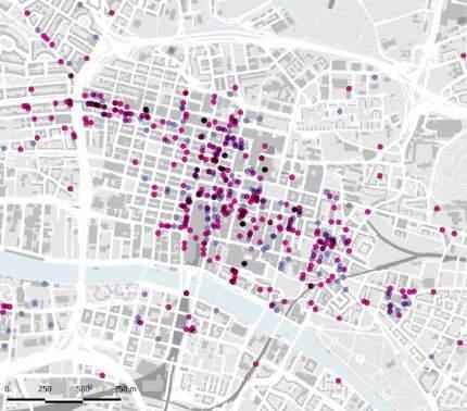
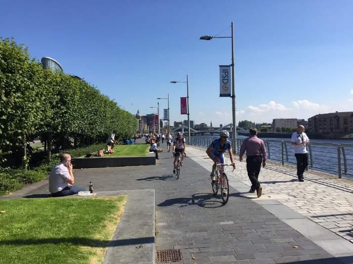
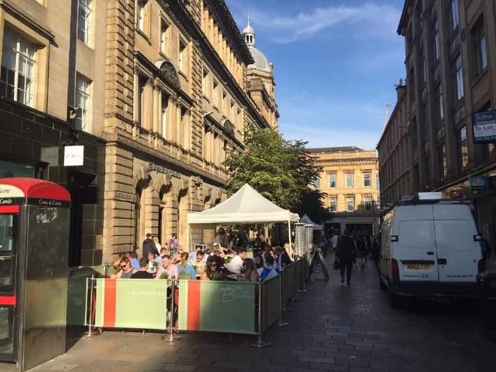
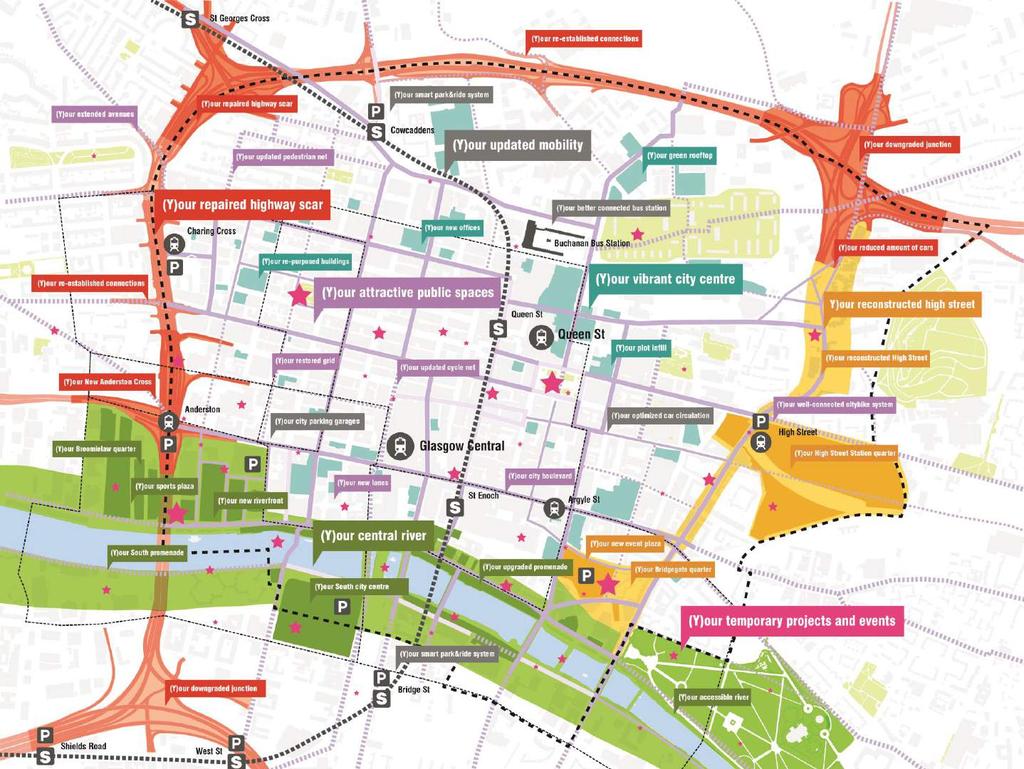
16 (Y)OUR CITY CENTRE
17 January February March April May June July August September October November December Average people per month Movement patterns Pedestrian Seasonal 1,500,000 1,400,000 City of Glasgow Springboard Pedestrian Survey Count 2016 Data availability: (Annual only) (52 weeks all day) Weekday and weekend 00:00 23:00 Data format: Hourly Survey location number: 4 1,300,000 1,200,000 1,100,000 1,000, , ,


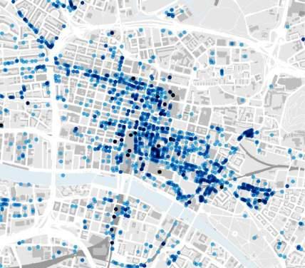
18 Springboard 2016 Week 3 Pedestrian count 00:00 01:00 02:00 03:00 04:00 05:00 06:00 07:00 08:00 09:00 10:00 11:00 12:00 13:00 14:00 15:00 16:00 17:00 18:00 19:00 20:00 21:00 22:00 23:00 00:00 01:00 02:00 03:00 04:00 05:00 06:00 07:00 08:00 09:00 10:00 11:00 12:00 13:00 14:00 15:00 16:00 17:00 18:00 19:00 20:00 21:00 22:00 23:00 Pedestrian count Movement patterns Pedestrian Weekday and weekend 7,000 6,000 5,000 4,000 3,000 2,000 1,000 0 Weekday City of Glasgow Springboard Pedestrian Survey Count 2016 Data availability: (Annual only) (52 weeks all day) Weekday and weekend 00:00 23:00 Data format: Hourly Survey location number: 4 Time Weekend 7,000 6,000 5,000 4,000 3,000 2,000 1,000 0 Time
19 Maryhill/Kelvin 10 K Springburn Crown copyright. OS Licence No Glasgow Commuting patterns Walking 10k radius Census Data 2011 Intermediate zone boundary Location of usual residence and place of work by method of transport. 36,768 people Partick West 2.4 K North East Govan Central Glasgow Calton Pollokshields Shettleston Greater Pollok Newlands Walking [2.4 K = 30 min walking] Commuting Pattern within Glasgow City

20 Crown copyright. OS Licence No Glasgow Commuting patterns Bicycle 10k radius 10 K Census Data 2011 Intermediate zone boundary Location of usual residence and place of work by method of transport. Maryhill/Kelvin 4,672 people Springburn Partick West 2.4 K North East Govan Central Glasgow Calton Pollokshields Shettleston Greater Pollok Newlands Bicycle Commuting Pattern within Glasgow City

21 Crown copyright. OS Licence No Glasgow Commuting patterns Public transport 10k radius 10 K Census Data 2011 Intermediate zone boundary Location of usual residence and place of work by method of transport. Maryhill/Kelvin 78,671 people Springburn Partick West North East Govan Central Glasgow Calton Pollokshields Shettleston Greater Pollok Newlands Public Transport Commuting Pattern within Glasgow City
22 Crown copyright. OS Licence No Glasgow Commuting patterns Private transport 10k radius 10 K Census Data 2011 Intermediate zone boundary Location of usual residence and place of work by method of transport. Maryhill/Kelvin 112,337 people Springburn Partick West North East Govan Central Glasgow Calton Pollokshields Shettleston Greater Pollok Newlands Private Transport Commuting Pattern within Glasgow City
 Census Data 2011 Intermediate zone boundary Location of usual residence and place of work by method of transport.")
23 Commuting patterns Modes of transport from and to Central Glasgow 10k radius Within City Centre To and from City Centre (10k) Census Data 2011 Intermediate zone boundary Location of usual residence and place of work by method of transport.
 Food and Drink (Class 3)")
 Residential Institutions and")
24 Shops (Class 1) Financial Services (Class 2) Food and Drink (Class 3) Business (Class 4) Hotels and Hostels (Class 7) Residential Institutions and Houses (Classes 8 and 9) Crown copyright. OS Licence No Urban function Land use
25 Crown copyright. OS Licence No Urban function Land use Cathedral Street High density of land use area Shops Financial Services Food and Drink Business Hotels and Hostels Residential Institutions and Houses

26 Crown copyright. OS Licence No Urban function Land use Blythswood and Central districts Cathedral Street High density of land use area Shops Financial Services Food and Drink Business Hotels and Hostels Residential Institutions and Houses


27 NACh_1200 Crown copyright. OS Licence No Spatial accessibility Urban character In general central Glasgow has a street network with high levels of accessibility. However, it is very localised to the north west of the city centre. While Argyle Street offers good levels of east-west accessibility, its length is surrounded by pockets of segmented streets. Due to its lack of connectivity with the localised route network, the M8 drops in significance at this localised scale. This is indicative of motorways that are designed solely for vehicles and global connectivity. At the local scale, the M8 becomes a negative attractor neutralising the potential of the fine grain street network. Therefore, economic and social activities that require to host localised movement would not succeed along its route. Spatial accessibility high low

![43,546 37,413 *Density 5,824 /sqk 7,776 /sqk 6,680/sqk **Total Street network Length 130,132 m 119,519 m 118,234 m *Street network length per person [mpp]*** 3,98 3,19 2,71 14 % 4 % 11 % Manchester 8](/docs-images/84/89357919/images/28-1.jpg "% *Highly Accessible Local and Global routes per person [mpp]*** 0.67 0.39 0.37 * Census 2011 Population by Data Zones intersected by Glasgow City Centre district boundary.")
28 % Street Network Length Crown copyright. OS Licence No Multi-scale analysis Glasgow Manchester Edinburgh Highly accessible routes values above 1.2 : Local and Global Global Local 18% 16% 14% 12% 10% Glasgow City Centre s Area Comparison: 8% 6% 4% 2% 0% 17 % Glasgow Manchester Edinburgh 8% Glasgow 17 % 12 % 3 % Edinburgh *Population 32,618 43,546 37,413 *Density 5,824 /sqk 7,776 /sqk 6,680/sqk **Total Street network Length 130,132 m 119,519 m 118,234 m *Street network length per person [mpp]*** 3,98 3,19 2,71 14 % 4 % 11 % Manchester 8 % *Highly Accessible Local and Global routes per person [mpp]*** * Census 2011 Population by Data Zones intersected by Glasgow City Centre district boundary. ** Street network Length inside Glasgow City Centre district boundary. ***meters per person.
29 Anderston Charing Cross Broomielaw NACh_n and R1200 Crown copyright. OS Licence No Multi-scale analysis Existing Glasgow Central Queen Street Highly accessible routes values above 1.2 : Local Global Local and Global Road Network < 1.2


30 Charing Cross Anderston Glasgow Central Broomielaw NACh_n and R1200 Crown copyright. OS Licence No Multi-scale analysis Existing + Cumulative Queen Street Existing Sauchiehall, Broomielaw and St.Enoch actions Highly accessible routes values above 1.2 : Local Global Local and Global Road Network < 1.2
31
32


33
Data driven approaches to Urban Planning Experience from Derry/Londonderry
 Data driven approaches to Urban Planning Experience from Derry/Londonderry Anna Rose RTPI Belfast 11 th of September 1 June 26 07:47AM 2 The value of the City The space of the city is a theatre: playing
City of Hermosa Beach Beach Access and Parking Study. Submitted by. 600 Wilshire Blvd., Suite 1050 Los Angeles, CA
 City of Hermosa Beach Beach Access and Parking Study Submitted by 600 Wilshire Blvd., Suite 1050 Los Angeles, CA 90017 213.261.3050 January 2015 TABLE OF CONTENTS Introduction to the Beach Access and Parking
Palmerston North Area Traffic Model
 Palmerston North Area Traffic Model Presentation to IPWEA 7 November 2014 PNATM Presentation Overview Model Scope and type Data collected The model Forecasting inputs Applications PNCC Aims and Objectives
OFFICES TO LET G2 4GZ
 OFFICES TO LET G2 4GZ TO LET 6,224 sq ft - 36,260 sq ft 225 Bath Street provides up to 36,260 sq ft of redefined, high quality office space in the centre of Glasgow. RAISE YOUR ROFILE Situated on the south
CORRIDORS OF FREEDOM Access Management (Ability) Herman Pienaar: Director City Transformation and Spatial Planning
 Herman Pienaar: Director City Transformation and Spatial Planning") CORRIDORS OF FREEDOM Access Management (Ability) 2016 Herman Pienaar: Director City Transformation and Spatial Planning PLANNING DEVELOPMENT PROCESS RATHER THAN A PLAN CAPITAL INVESTMENT DEVELOPMENT FACILITATION
CORRIDORS OF FREEDOM Access Management (Ability) 2016 Herman Pienaar: Director City Transformation and Spatial Planning PLANNING DEVELOPMENT PROCESS RATHER THAN A PLAN CAPITAL INVESTMENT DEVELOPMENT FACILITATION
Measuring connectivity in London
 Measuring connectivity in London OECD, Paris 30 th October 2017 Simon Cooper TfL City Planning 1 Overview TfL Connectivity measures in TfL PTALs Travel time mapping Catchment analysis WebCAT Current and
California Urban Infill Trip Generation Study. Jim Daisa, P.E.
 California Urban Infill Trip Generation Study Jim Daisa, P.E. What We Did in the Study Develop trip generation rates for land uses in urban areas of California Establish a California urban land use trip
Monthly Magnetic Bulletin
 BRITISH GEOLOGICAL SURVEY Ascension Island Observatory Monthly Magnetic Bulletin December 2008 08/12/AS Crown copyright; Ordnance Survey ASCENSION ISLAND OBSERVATORY MAGNETIC DATA 1. Introduction Ascension
Mapping Accessibility Over Time
 Journal of Maps, 2006, 76-87 Mapping Accessibility Over Time AHMED EL-GENEIDY and DAVID LEVINSON University of Minnesota, 500 Pillsbury Drive S.E., Minneapolis, MN 55455, USA; geneidy@umn.edu (Received
Geodatabase for Sustainable Urban Development. Presented By Rhonda Maronn Maurice Johns Daniel Ashney Jack Anliker
 Geodatabase for Sustainable Urban Development Presented By Rhonda Maronn Maurice Johns Daniel Ashney Jack Anliker Objective Build a Geodatabase that will enable urban planners to create and assess the
CERTIFIED RESOLUTION. introduction: and dated May 29, 2017, as attached, as appropriate
 15322 Buena Vista Avenue, White Rock BC, Canada V4B 1Y6 www.whiterockcity.ca City of White Rock P: 604.541.22121 F: 604.541.9348 /2tC% City Clerk s Office IT E ROC K June 13,2017 Stephanie Lam, Deputy
PRIMA. Planning for Retailing in Metropolitan Areas
 PRIMA Planning for Retailing in Metropolitan Areas Metropolitan Dimension to sustainable retailing futures Metropolitan strategies Retailing in city and town centres will be a primary component of any
Travel behavior of low-income residents: Studying two contrasting locations in the city of Chennai, India
 Travel behavior of low-income residents: Studying two contrasting locations in the city of Chennai, India Sumeeta Srinivasan Peter Rogers TRB Annual Meet, Washington D.C. January 2003 Environmental Systems,
Assessing the impact of seasonal population fluctuation on regional flood risk management
 Assessing the impact of seasonal population fluctuation on regional flood risk management Alan Smith *1, Andy Newing 2, Niall Quinn 3, David Martin 1 and Samantha Cockings 1 1 Geography and Environment,
CITY OF CEDAR FALLS D O W N T O W N PA R K I N G S T U D Y P U B L I C W O R K S H O P D E C E M B E R 5,
 CITY OF CEDAR FALLS D O W N T O W N PA R K I N G S T U D Y P U B L I C W O R K S H O P D E C E M B E R 5, 2 0 1 8 PA R K I N G S T U D Y S C O P E O F W O R K Parking study methodology Parking inventory
3. If a forecast is too high when compared to an actual outcome, will that forecast error be positive or negative?
 1. Does a moving average forecast become more or less responsive to changes in a data series when more data points are included in the average? 2. Does an exponential smoothing forecast become more or
Assessing spatial distribution and variability of destinations in inner-city Sydney from travel diary and smartphone location data
 Assessing spatial distribution and variability of destinations in inner-city Sydney from travel diary and smartphone location data Richard B. Ellison 1, Adrian B. Ellison 1 and Stephen P. Greaves 1 1 Institute
The Spatial Structure of Cities: International Examples of the Interaction of Government, Topography and Markets
 Module 2: Spatial Analysis and Urban Land Planning The Spatial Structure of Cities: International Examples of the Interaction of Government, Topography and Markets Alain Bertaud Urbanist Summary What are
Exploring the Impact of Ambient Population Measures on Crime Hotspots
 Exploring the Impact of Ambient Population Measures on Crime Hotspots Nick Malleson School of Geography, University of Leeds http://nickmalleson.co.uk/ N.S.Malleson@leeds.ac.uk Martin Andresen Institute
Mountain View Community Shuttle Monthly Operations Report
 Mountain View Community Shuttle Monthly Operations Report December 6, 2018 Contents Passengers per Day, Table...- 3 - Passengers per Day, Chart...- 3 - Ridership Year-To-Date...- 4 - Average Daily Ridership
Dublin Chamber submission on Dublin City Development Plan : Outdoor Advertising Strategy
 Dublin Chamber submission on Dublin City Development Plan 2011 2017: Outdoor Advertising Strategy January 2012 Key Points: Sustainable and appropriate advertising can play an important positive role in
City of Johannesburg Department: Development Planning And Urban Management Development Planning and Facilitation
 City of Johannesburg Department: Development Planning And Urban Management Development Planning and Facilitation Marlboro Urban Development Framework: Discussion Document July 2007 1 Prepared for Department
Mountain View Community Shuttle Monthly Operations Report
 Mountain View Community Shuttle Monthly Operations Report October 9, 2018 Contents Passengers per Day, Table...- 3 - Passengers per Day, Chart...- 3 - Ridership Year-To-Date...- 4 - Average Daily Ridership
Crime Analysis. GIS Solutions for Intelligence-Led Policing
 Crime Analysis GIS Solutions for Intelligence-Led Policing Applying GIS Technology to Crime Analysis Know Your Community Analyze Your Crime Use Your Advantage GIS aids crime analysis by Identifying and
Committee Meeting November 6, 2018
 Committee Meeting November 6, 2018 Agenda Where we are in the process Land Use Plan Transportation Element Housing & Neighborhoods Elements Next Steps Schedule November 6: Plan Elements December: Plan
Preliminary Material Data Sheet
 Level 1/Level 2 Certificate Foundation Level June 2015 Use of Mathematics 43503F/PM Core unit Preliminary Material Data Sheet To be opened and issued to candidates between Monday 27 April 2015 and Monday
Urban Planning Word Search Level 1
 Urban Planning Word Search Level 1 B C P U E C O S Y S T E M P A R E U O E U R B A N P L A N N E R T N S T D H E C O U N T Y G E R E R D W R E N I C I T Y C O U N C I L A A A S U G G C I L A G P R I R
Monthly Magnetic Bulletin
 BRITISH GEOLOGICAL SURVEY Port Stanley Observatory Monthly Magnetic Bulletin December 2007 07/12/PS Jason Islands a ar C West Falkland Kin gg eor ge B Port Salavador ay Weddell Island Mount Osborne So
PREPARED DIRECT TESTIMONY OF GREGORY TEPLOW SOUTHERN CALIFORNIA GAS COMPANY AND SAN DIEGO GAS & ELECTRIC COMPANY
 Application No: A.1-0- Exhibit No.: Witness: Gregory Teplow Application of Southern California Gas Company (U 0 G) and San Diego Gas & Electric Company (U 0 G) for Authority to Revise their Natural Gas
Attachment 3. Updating UBC s Regional Context Statement. University of British Columbia CONSIDERATION MEMORANDUM OF CONSULTATION INPUT
 Attachment 3 University of British Columbia Updating UBC s Regional Context Statement CONSIDERATION MEMORANDUM OF CONSULTATION INPUT Campus and Community Planning February 24, 2014 1 CONSIDERATION MEMORANDUM
QUANTIFICATION OF THE NATURAL VARIATION IN TRAFFIC FLOW ON SELECTED NATIONAL ROADS IN SOUTH AFRICA
 QUANTIFICATION OF THE NATURAL VARIATION IN TRAFFIC FLOW ON SELECTED NATIONAL ROADS IN SOUTH AFRICA F DE JONGH and M BRUWER* AECOM, Waterside Place, Tygerwaterfront, Carl Cronje Drive, Cape Town, South
TREASURE COAST REGIONAL PLANNING COUNCIL M E M O R A N D U M. To: Council Members AGENDA ITEM 4B10
 TREASURE COAST REGIONAL PLANNING COUNCIL M E M O R A N D U M To: Council Members AGENDA ITEM 4B10 From: Date: Subject: Staff December 14, 2018 Council Meeting Local Government Comprehensive Plan Review
Council Workshop on Neighbourhoods Thursday, October 4 th, :00 to 4:00 p.m. Burlington Performing Arts Centre
 Council Workshop on Neighbourhoods Thursday, October 4 th, 2012 1:00 to 4:00 p.m. Burlington Performing Arts Centre Agenda Introductions Warm-Up Exercise Presentation Exercise Neighbourhood Planning Break
Accessibility as an Instrument in Planning Practice. Derek Halden DHC 2 Dean Path, Edinburgh EH4 3BA
 Accessibility as an Instrument in Planning Practice Derek Halden DHC 2 Dean Path, Edinburgh EH4 3BA derek.halden@dhc1.co.uk www.dhc1.co.uk Theory to practice a starting point Shared goals for access to
Accessibility analysis of multimodal transport systems using advanced GIS techniques
 Urban Transport XIII: Urban Transport and the Environment in the 21st Century 655 Accessibility analysis of multimodal transport systems using advanced GIS techniques T. Vorraa Citilabs Regional Director,
Transport Planning in Large Scale Housing Developments. David Knight
 Transport Planning in Large Scale Housing Developments David Knight Large Scale Housing Developments No longer creating great urban spaces in the UK (Hall 2014) Transport Planning Transport planning processes
GOVERNMENT MAPPING WORKSHOP RECOVER Edmonton s Urban Wellness Plan Mapping Workshop December 4, 2017
 GOVERNMENT MAPPING WORKSHOP 12.4.17 RECOVER Edmonton s Urban Wellness Plan Mapping Workshop December 4, 2017 In July of 2017, City Council directed administration to develop RECOVER, Edmonton s Urban Wellness
Dar es Salaam - Reality Check Workshop
 Dar es Salaam - Reality Check Workshop hosted by GIZ and Dar es Salaam City Council Introduction: Key Urban Characteristics of Dar es Salaam Challenges and Opportunities for Resilient Development in the
Regional Transit Development Plan Strategic Corridors Analysis. Employment Access and Commuting Patterns Analysis. (Draft)
") Regional Transit Development Plan Strategic Corridors Analysis Employment Access and Commuting Patterns Analysis (Draft) April 2010 Contents 1.0 INTRODUCTION... 4 1.1 Overview and Data Sources... 4 1.2
Regional Transit Development Plan Strategic Corridors Analysis Employment Access and Commuting Patterns Analysis (Draft) April 2010 Contents 1.0 INTRODUCTION... 4 1.1 Overview and Data Sources... 4 1.2
Frequently Asked Questions
 What is the Regional Transit Engagement Series? As one of the fastest growing regions in the country, there is recognition that long-term transit planning efforts should be accelerated if we are to remain
SNOW CONTROL OPERATIONS
 SNOW CONTROL OPERATIONS PUBLIC WORKS TEAM STREET MAINTENANCE DIVISION SNOW CONTROL OPERATIONS Standard Operating Procedures for Snow Removal Operations. 1. Plowing operations will be initiated when snow
M. Saraiva* 1 and J. Barros 1. * Keywords: Agent-Based Models, Urban Flows, Accessibility, Centrality.
 The AXS Model: an agent-based simulation model for urban flows M. Saraiva* 1 and J. Barros 1 1 Department of Geography, Birkbeck, University of London, 32 Tavistock Square, London, WC1H 9EZ *Email: m.saraiva@mail.bbk.ac.uk
Detecting Origin-Destination Mobility Flows From Geotagged Tweets in Greater Los Angeles Area
 Detecting Origin-Destination Mobility Flows From Geotagged Tweets in Greater Los Angeles Area Song Gao 1, Jiue-An Yang 1,2, Bo Yan 1, Yingjie Hu 1, Krzysztof Janowicz 1, Grant McKenzie 1 1 STKO Lab, Department
CALOTS Upgrade for Performance Monitoring
 CALOTS Upgrade for Performance Monitoring A project of the Southern California Association of Governments supported by the UCLA Lewis Center for Regional Policy Studies Agenda 1. Revisit Project Overview
Project Appraisal Guidelines
 Project Appraisal Guidelines Unit 16.2 Expansion Factors for Short Period Traffic Counts August 2012 Project Appraisal Guidelines Unit 16.2 Expansion Factors for Short Period Traffic Counts Version Date
Forecasts from the Strategy Planning Model
 Forecasts from the Strategy Planning Model Appendix A A12.1 As reported in Chapter 4, we used the Greater Manchester Strategy Planning Model (SPM) to test our long-term transport strategy. A12.2 The origins
I. M. Schoeman North West University, South Africa. Abstract
 Urban Transport XX 607 Land use and transportation integration within the greater area of the North West University (Potchefstroom Campus), South Africa: problems, prospects and solutions I. M. Schoeman
A new type of RICEPOTS
 A new type of RICEPOTS Alan Parkinson Geography teaching resource College Crown Copyright and Database Right 2014. Ordnance Survey (Digimap Licence) This is one of a series of teaching resources for use
A route map to calibrate spatial interaction models from GPS movement data
 A route map to calibrate spatial interaction models from GPS movement data K. Sila-Nowicka 1, A.S. Fotheringham 2 1 Urban Big Data Centre School of Political and Social Sciences University of Glasgow Lilybank
Metrolinx Transit Accessibility/Connectivity Toolkit
 Metrolinx Transit Accessibility/Connectivity Toolkit Christopher Livett, MSc Transportation Planning Analyst Research and Planning Analytics Tweet about this presentation #TransitGIS OUTLINE 1. Who is
HSC Geography. Year 2013 Mark Pages 10 Published Jul 4, Urban Dynamics. By James (97.9 ATAR)
") HSC Geography Year 2013 Mark 92.00 Pages 10 Published Jul 4, 2017 Urban Dynamics By James (97.9 ATAR) Powered by TCPDF (www.tcpdf.org) Your notes author, James. James achieved an ATAR of 97.9 in 2013 while
HSC Geography Year 2013 Mark 92.00 Pages 10 Published Jul 4, 2017 Urban Dynamics By James (97.9 ATAR) Powered by TCPDF (www.tcpdf.org) Your notes author, James. James achieved an ATAR of 97.9 in 2013 while
Figure 8.2a Variation of suburban character, transit access and pedestrian accessibility by TAZ label in the study area
 Figure 8.2a Variation of suburban character, transit access and pedestrian accessibility by TAZ label in the study area Figure 8.2b Variation of suburban character, commercial residential balance and mix
NEW YORK DEPARTMENT OF SANITATION. Spatial Analysis of Complaints
 NEW YORK DEPARTMENT OF SANITATION Spatial Analysis of Complaints Spatial Information Design Lab Columbia University Graduate School of Architecture, Planning and Preservation November 2007 Title New York
MINISTÉRIO DAS FINANÇAS DIRECÇÃO GERAL DE ESTATÍSTICA DIRECÇÃO NACIONAL DE ESTATÍSTICA ECONOMICAS E SOCIAIS
 MINISTÉRIO DAS FINANÇAS DIRECÇÃO GERAL DE ESTATÍSTICA DIRECÇÃO NACIONAL DE ESTATÍSTICA ECONOMICAS E SOCIAIS CPI SERI 2 EDITION THIRD ISSUE www.dne.mof.gov.tl MINISTÉRIO DAS FINANÇAS DIRECÇÃO GERAL DE ESTATÍSTICA
Smart Solutions for Spatial Planning
 Smart Solutions for Spatial Planning Aedas R&D [Computational Design Research] Centre for Evolutionary Computing in Architecture [CECA @ UEL] Knowledge Transfer [breaking silos] * constructing consensus
Monthly Magnetic Bulletin
 BRITISH GEOLOGICAL SURVEY Ascension Island Observatory Monthly Magnetic Bulletin March 2017 17/03/AS Crown copyright; Ordnance Survey ASCENSION ISLAND OBSERVATORY MAGNETIC DATA 1. Introduction Ascension
Technical Memorandum #2 Future Conditions
 Technical Memorandum #2 Future Conditions To: Dan Farnsworth Transportation Planner Fargo-Moorhead Metro Council of Governments From: Rick Gunderson, PE Josh Hinds PE, PTOE Houston Engineering, Inc. Subject:
COUNCIL POLICY MANUAL
 COUNCIL POLICY MANUAL SECTION: PUBLIC WORKS SUBJECT: SNOW & ICE CONTROL POLICY 2012/2013 GOAL: Pages: 1 of 10 Approval Date: Dec. 3, 2012 Res. # 1001/2012 To annually identify the winter maintenance costs
Multivariate Regression Model Results
 Updated: August, 0 Page of Multivariate Regression Model Results 4 5 6 7 8 This exhibit provides the results of the load model forecast discussed in Schedule. Included is the forecast of short term system
Victorian Liveability Indicator Program: Definition, Measurement and Application
 Victorian Liveability Indicator Program: Definition, Measurement and Application Dr Hannah Badland Senior Research Fellow Place, Health, and Liveability Program Melbourne School of Population and Global
Dr.Sinisa Vukicevic Dr. Robert Summers
 Dr.Sinisa Vukicevic Dr. Robert Summers "Planning" means the scientific, aesthetic, and orderly disposition of land, resources, facilities and services with a view to securing the physical, economic and
Managing Growth: Integrating Land Use & Transportation Planning
 Managing Growth: Integrating Land Use & Transportation Planning Metro Vancouver Sustainability Community Breakfast Andrew Curran Manager, Strategy June 12, 2013 2 Integrating Land Use & Transportation
Chapter 1 Data Collection
 Chapter 1 Data Collection 1. Climate of Brunei Darussalam and Temburong District Situated at around four degrees north of the Equator, Brunei Darussalam enjoys an equatorial climate with an abundance of
MINISTÉRIO DAS FINANÇAS DIRECÇÃO GERAL DE ESTATÍSTICA DIRECÇÃO NACIONAL DE ESTATÍSTICA ECONOMICAS E SOCIAIS
 MINISTÉRIO DAS FINANÇAS DIRECÇÃO GERAL DE ESTATÍSTICA DIRECÇÃO NACIONAL DE ESTATÍSTICA ECONOMICAS E SOCIAIS CPI SERI 2 EDITION ONE ISSUE www.dne.mof.gov.tl MINISTÉRIO DAS FINANÇAS DIRECÇÃO GERAL DE ESTATÍSTICA
City and SUMP of Ravenna
 City and SUMP of Ravenna Nicola Scanferla Head of Mobility Planning Unit, Municipality of Ravenna nscanferla@comune.ra.it place your logo here 19 April, 2017 1st Steering Committee Meeting, Nicosia, Cyprus
Social Studies Grade 2 - Building a Society
 Social Studies Grade 2 - Building a Society Description The second grade curriculum provides students with a broad view of the political units around them, specifically their town, state, and country.
Date: June 19, 2013 Meeting Date: July 5, Consideration of the City of Vancouver s Regional Context Statement
 Section E 1.5 To: From: Regional Planning and Agriculture Committee Lee-Ann Garnett, Senior Regional Planner Planning, Policy and Environment Department Date: June 19, 2013 Meeting Date: July 5, 2013 Subject:
Neighborhood Locations and Amenities
 University of Maryland School of Architecture, Planning and Preservation Fall, 2014 Neighborhood Locations and Amenities Authors: Cole Greene Jacob Johnson Maha Tariq Under the Supervision of: Dr. Chao
An online data and consulting resource of THE UNIVERSITY OF TOLEDO THE JACK FORD URBAN AFFAIRS CENTER
 An online data and consulting resource of THE JACK FORD URBAN AFFAIRS CENTER THE CENTER FOR GEOGRAPHIC INFORMATION SCIENCE AND APPLIED GEOGRAPHICS DEPARTMENT OF GEOGRAPHY AND PLANNING THE UNIVERSITY OF
Measurement of human activity using velocity GPS data obtained from mobile phones
 Measurement of human activity using velocity GPS data obtained from mobile phones Yasuko Kawahata 1 Takayuki Mizuno 2 and Akira Ishii 3 1 Graduate School of Information Science and Technology, The University
Parking Regulations Dundas Street West, from Bathurst Street to Dovercourt Road
 STAFF REPORT ACTION REQUIRED Parking Regulations Dundas Street West, from Bathurst Street to Dovercourt Road Date: October 28, 2008 To: From: Toronto and East York Community Council Director, Transportation
Implementation Status & Results Burkina Faso TRANSPORT SECTOR PROJECT (P074030)
") losure Authorized Public Disclosure Authorized Public Disclosure Authorized Public Disclosure Authorized Implementation Status & Results Burkina Faso TRANSPORT SECTOR PROJECT (P074030) Operation Name:
losure Authorized Public Disclosure Authorized Public Disclosure Authorized Public Disclosure Authorized Implementation Status & Results Burkina Faso TRANSPORT SECTOR PROJECT (P074030) Operation Name:
IGCSE Geography Unit 2: Types of Settlement
 IGCSE Geography Unit 2: Types of Settlement Recommended Prior Knowledge An understanding of the factors that affect the nature, location, growth and structure of settlements. A good general knowledge,
Regional Growth Strategy Work Session Growth Management Policy Board
 Regional Growth Strategy Work Session Growth Management Policy Board September 6, 2018 1 Overview Recap June GMPB work session Objectives and outcomes Regional geographies Growth scenarios Breakout Discussion:
Subject: Note on spatial issues in Urban South Africa From: Alain Bertaud Date: Oct 7, A. Spatial issues
 Page 1 of 6 Subject: Note on spatial issues in Urban South Africa From: Alain Bertaud Date: Oct 7, 2009 A. Spatial issues 1. Spatial issues and the South African economy Spatial concentration of economic
Environmental Analysis, Chapter 4 Consequences, and Mitigation
 Environmental Analysis, Chapter 4 4.17 Environmental Justice This section summarizes the potential impacts described in Chapter 3, Transportation Impacts and Mitigation, and other sections of Chapter 4,
2018 Annual Review of Availability Assessment Hours
 2018 Annual Review of Availability Assessment Hours Amber Motley Manager, Short Term Forecasting Clyde Loutan Principal, Renewable Energy Integration Karl Meeusen Senior Advisor, Infrastructure & Regulatory
KEELE UNIVERSITY SNOW AND SEVERE WEATHER MANAGEMENT PLAN
 1.0 Introduction 1.1 It is recognised that severe weather conditions, particularly snow and ice, can make it difficult for people to travel. However, as a residential campus, even during severe weather
Trip and Parking Generation Study of Orem Fitness Center-Abstract
 Trip and Parking Generation Study of Orem Fitness Center-Abstract The Brigham Young University Institute of Transportation Engineers student chapter (BYU ITE) completed a trip and parking generation study
HORIZON 2030: Land Use & Transportation November 2005
 PROJECTS Land Use An important component of the Horizon transportation planning process involved reviewing the area s comprehensive land use plans to ensure consistency between them and the longrange transportation
Chapter 1 0+7= 1+6= 2+5= 3+4= 4+3= 5+2= 6+1= 7+0= How would you write five plus two equals seven?
 Chapter 1 0+7= 1+6= 2+5= 3+4= 4+3= 5+2= 6+1= 7+0= If 3 cats plus 4 cats is 7 cats, what does 4 olives plus 3 olives equal? olives How would you write five plus two equals seven? Chapter 2 Tom has 4 apples
2129 NORTH MAIN STREET HOTE PROJECT ULI SHARED PARKING STUDY City of Santa Ana, California
 2129 NORTH MAIN STREET HOTE PROJECT ULI SHARED PARKING STUDY City of Santa Ana, California Prepared for: NET DEVELOPMENT COMPANY 3130 Airway Avenue Costa Mesa, CA 92626 Prepared by: RK ENGINEERING GROUP,
WOODRUFF ROAD CORRIDOR ORIGIN-DESTINATION ANALYSIS
 2018 WOODRUFF ROAD CORRIDOR ORIGIN-DESTINATION ANALYSIS Introduction Woodruff Road is the main road to and through the commercial area in Greenville, South Carolina. Businesses along the corridor have
Vital city lively neighborhood living center
 From the ugliest place to heart of the suburb Vital city lively neighborhood living center Marja Straver - Nevalainen September 12 th, 2012 If you want to see the sun, t th look next to it to NL FI 10x
GIS Analysis of Crenshaw/LAX Line
 PDD 631 Geographic Information Systems for Public Policy, Planning & Development GIS Analysis of Crenshaw/LAX Line Biying Zhao 6679361256 Professor Barry Waite and Bonnie Shrewsbury May 12 th, 2015 Introduction
Local Area Key Issues Paper No. 13: Southern Hinterland townships growth opportunities
 Draft Sunshine Coast Planning Scheme Review of Submissions Local Area Key Issues Paper No. 13: Southern Hinterland townships growth opportunities Key Issue: Growth opportunities for Southern Hinterland
Data Collection. Lecture Notes in Transportation Systems Engineering. Prof. Tom V. Mathew. 1 Overview 1
 Data Collection Lecture Notes in Transportation Systems Engineering Prof. Tom V. Mathew Contents 1 Overview 1 2 Survey design 2 2.1 Information needed................................. 2 2.2 Study area.....................................
STUDY ON RELATIONSHIP BETWEEN CATCHMENT AND BUILT ENVIRONMENT OF METRO STATIONS IN HONG KONG AND SHENZHEN. Yin Ziyuan
 STUDY ON RELATIONSHIP BETWEEN CATCHMENT AND BUILT ENVIRONMENT OF METRO STATIONS IN HONG KONG AND SHENZHEN Yin Ziyuan DOCTOR OF PHILOSOPHY CITY UNIVERSITY OF HONG KONG JUNE 2014 CITY UNIVERSITY OF HONG
Proposed Scope of Work Village of Farmingdale Downtown Farmingdale BOA Step 2 BOA Nomination Study / Draft Generic Environmental Impact Statement
 Proposed Scope of Work Village of Farmingdale Downtown Farmingdale BOA Step 2 BOA Nomination Study / Draft Generic Environmental Impact Statement The scope of work that follows incorporates and covers
The World Bank Heilongjiang Cold Weather Smart Public Transportation System (P133114)
") Public Disclosure Authorized EAST ASIA AND PACIFIC China Transport Global Practice IBRD/IDA Investment Project Financing FY 2014 Seq No: 2 ARCHIVED on 09-Dec-2014 ISR17411 Implementing Agencies: Heilongjiang
Public Disclosure Authorized EAST ASIA AND PACIFIC China Transport Global Practice IBRD/IDA Investment Project Financing FY 2014 Seq No: 2 ARCHIVED on 09-Dec-2014 ISR17411 Implementing Agencies: Heilongjiang
Shaping Your Neighbourhood
 Shaping Your Neighbourhood Building a Core Sustainable Neighbourhood Action Plan Nov. 25 & 26, 2006 Welcome! Peter Russell Planner, Holland Barrs Planning Group Inc. Role in this project: Work with the
NEW WATERFRONT METROPARK. P u b l i c O p e n H o u s e, J u n e 2 1,
 NEW WATERFRONT METROPARK P u b l i c O p e n H o u s e, J u n e 2 1, 2 0 1 7 U N D E R S T A N D I N G YO U R P E R S P E C T I V E PUBLIC OPEN HOUSE Welcome/Introductions Project Presentation Project
River North Multi-Modal Transit Analysis
 River North Multi-Modal Transit Analysis November 7, 2006 Dan Meyers, AICP URS Corporation 612-373-6446 / dan_meyers@urscorp.com River North Study Area Reasons for initiating the study Downtown areas north
APPENDIX I - AREA PLANS
 ROUTE 37 WEST LAND USE PLAN ROUTE 37 WEST LAND USE PLAN Recent land use decisions and development trends have drawn attention to the land within the Route 37 western by-pass area between Route 50 and
CHANGES IN THE STRUCTURE OF POPULATION AND HOUSING FUND BETWEEN TWO CENSUSES 1 - South Muntenia Development Region
 TERITORIAL STATISTICS CHANGES IN THE STRUCTURE OF POPULATION AND HOUSING FUND BETWEEN TWO CENSUSES 1 - South Muntenia Development Region PhD Senior Lecturer Nicu MARCU In the last decade, a series of structural
Background of Project
 RELOCATION OF GRESHAM FIRE STATION #76 Mike Shelby Annie Scriven Andrea Consalus Background of Project Wanted to do a project that was meaningful Contacted Molly Vogt, GIS Manager at City of Gresham Informed
38th UNWTO Affiliate Members Plenary Session Yerevan, Armenia, 4 October 2016
 38th UNWTO Affiliate Members Plenary Session Yerevan, Armenia, 4 October 2016 17:00-19:00 Open Debate 5: City Tourism Introduced and Moderated by Dr. Donald Hawkins George Washington University World urban
Encapsulating Urban Traffic Rhythms into Road Networks
 Encapsulating Urban Traffic Rhythms into Road Networks Junjie Wang +, Dong Wei +, Kun He, Hang Gong, Pu Wang * School of Traffic and Transportation Engineering, Central South University, Changsha, Hunan,
Christina Karaberi- Msc Health Management European Program Manager ITR. CityMobil2 Reference Group Meeting, Antibes, France 22/03/206
 TRIKALA DEMONSTRATION TITLE A CTS SITE- FOR Large THE Scale PerspectiveNEW ROME EXHIBITION Christina Karaberi- Msc Health Management European Program Manager E-Trikala Gabriele S.A Giustiniani, ITR 22/03/206
RETA 6422: Mainstreaming Environment for Poverty Reduction Category 2 Subproject
 RETA 6422: Mainstreaming Environment for Poverty Reduction Category 2 Subproject A. Basic Data 1. Subproject Title: Poverty-Environment Mapping to Support Decision Making 2. Country Director: Adrian Ruthenberg