Assessing the impact of seasonal population fluctuation on regional flood risk management
|
|
|
- Barnaby McDaniel
- 5 years ago
- Views:
Transcription
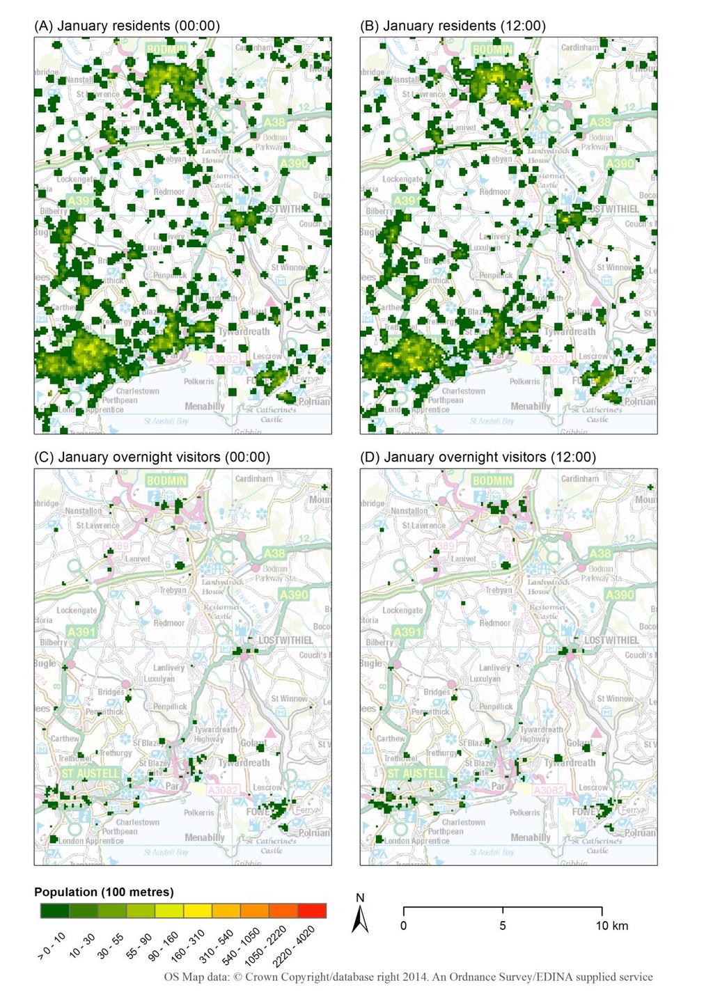
1 Assessing the impact of seasonal population fluctuation on regional flood risk management Alan Smith *1, Andy Newing 2, Niall Quinn 3, David Martin 1 and Samantha Cockings 1 1 Geography and Environment, University of Southampton, UK 2 School of Geography, University of Leeds, UK 3 School of Geographical Sciences, University of Bristol, UK 03 November 2014 Summary This paper focuses on the integration of population and environmental models to address the effect of seasonally varying populations on exposure to flood risk. A spatiotemporal population modelling tool, Population24/7, has been combined with LISFLOOD-FP inundation model outputs for a study area centred on St Austell, Cornwall, UK. Results indicate seasonal cycles in populations and their exposure to flood hazard which are not accounted for in traditional population datasets or flood hazard analyses and which provide potential enhancements to current practice. KEYWORDS: Spatiotemporal population modelling, flood risk, Population24/7, LISFLOOD-FP, seasonality. 1. Introduction Previous research applying high resolution spatiotemporal population modelling to flood risks has shown large variations in population exposure over time and space (e.g. Smith et al. 2014). A major refinement in this approach has been the inclusion of seasonally varying overnight visitor population estimates developed by Newing et al. (2013). These have been integrated within the flexible Population24/7 data framework (Martin et al. forthcoming) which can be used to produce spatiotemporal gridded population estimates using variable kernel density estimation methods. This paper demonstrates analysis of seasonal variations in population exposure to flood risk using a local case study. It combines spatiotemporal population estimates with an extract from the national Environment Agency (EA) flood map and bespoke LISFLOOD-FP inundation modelling. The integration of seasonal tourist population estimates represents an advance in modelling spatiotemporal populations for applications such as population hazard exposure. 2. Case study: St Austell, Cornwall This study is based on a km study area centred on St Austell Bay, Cornwall, UK (Figure 1). Coastal resorts within the study area, such as Par, Polkeris and Fowey, experience considerable seasonal fluctuations in population driven by an influx of domestic overnight visitors. * Alan.Smith@soton.ac.uk

2 The study area is subject to fluvial, tidal and surface water flooding. The warning system on the River Par provides less than two hours notice of flooding (EA 2012a). The tide-locking of local watercourses during high tides prevents drainage at coastal outlets and poses an additional risk of fluvial flooding. Tidal flood risk dominates the east of the study area. The Par area contains the highest number of properties at risk from current and predicted future flooding in Cornwall (EA 2012b). 3. Methods and data Hourly population estimates at 100 metre resolution have been produced for a typical weekday in January, May and August 2010 using the SurfaceBuilder247 software tool ( These scenarios demonstrate the considerable variation seen in estimated seasonal visitor numbers within the case study area, reflecting the low, fringe and peak tourist seasons respectively. Population is redistributed from origin (residential locations) to destination (e.g. locations of work, study, leisure) centroids. Population redistribution is constrained by a dasymetric background mask which includes the road transport network. The occupation of destination centroids is governed by a temporal profile specific to each site (e.g. a school occupied during school hours in term-time). The modelling framework is described in greater detail by Martin et al. (forthcoming). This particular application integrates novel overnight visitor population estimates within the modelling framework (Section 3.1) and combines these with bespoke flood inundation modelling using LISFLOOD-FP (Section 3.2).

3 3.1. Seasonal population fluctuation Tourist visitor populations have a tendency to cluster in both space and time. In coastal areas, such as St Austell Bay, a concentration of visitor accommodation, attractions and other facilities generate spatial clusters of visitors, with numbers known to fluctuate at different times of the year, driven by the weather, local and national events, the institutional calendar and the operating season at accommodation sites and major attractions. In contrast to residential and workplace populations, very little is known about the spatial or temporal distribution of overnight visitors below the local authority district level. We make use of a novel dataset estimating the seasonal and spatial distribution of visitors based on the provision and utilisation of tourist accommodation (Newing et al. 2013) Overnight visitor population estimates (Table 1) were built from the bottom-up using local data collection and taking individual accommodation units (e.g. a hotel room, self-catering cottage or camping pitch) as the building block, aggregated to the unit postcode or census Output Area (OA) level to form visitor origins. Visitors staying with friends and relatives are distributed across the existing housing stock, whilst major holiday parks and camping and caravanning sites generate spatial and temporal clusters of overnight visitor populations in areas which may have few or no usual residents. In common with the approach used for residential populations, visitor populations are redistributed from their overnight origins to daytime locations such as major attractions, the transport network and leisure locations which may not traditionally be thought of as clusters of population in the same way as workplaces, hospitals and retail centres. Given the coastal and estuarine nature of the study area, some of these locations may also be at flood risk Flood inundation modelling (LISFLOOD-FP) Three flood scenarios representing return periods (R) of 100, 250 and 500 years have been created using LISFLOOD-FP, a raster based flood inundation model, for an 8 4 km subsection of the study area (Figure 2). The return period represents the likelihood of an event of a given magnitude occurring. In addition, the EA s flood map zone three (FMZ3) represents the amalgamation of return periods for events of 100 (fluvial) and 200 (tidal) years. FMZ3 contains a greater extent of inland fluvial flooding whereas the bespoke LISFLOOD-FP outputs specifically account for defences and other structures.

4 4. Results and discussion This section presents the integration and analysis of spatiotemporal seasonal population estimates and flood inundation models. Figure 3 shows hourly spatiotemporal population estimates representing a typical working weekday within each seasonal scenario. It shows the population exposure to the EA s FMZ3 for the whole study area. It has been compared with static exposure estimates from rasterised census outputs representing: the baseline 2001 Census population at OA level (highest resolution available), 2001 Census daytime population at OA (only available for 2001) and the 2010 mid-year estimate (closest to target date but only available LSOA level).

5 The seasonal spatiotemporal variation is illustrated for weekday midday (12:00) and midnight (00:00) population estimates for two of the seasons modelled (January and August) (Figures 4 and 5). In both examples there is a general redistribution of the usually resident day-time population from the nighttime locations to the main population centres (analogous with the main workplace locations), reflecting a daily transition from the surrounding rural areas into urban locations. The overnight visitor population increases by over 1000% January-August (Table 1) and is concentrated at leisure activity locations during the day. Figure 6 shows modelled population results with OS map extracts and aerial imagery for 1 km national grid squares, providing detailed examples for an August weekday at 12:00 and 00:00. Daytime locations with example visitor leisure attractions are shown in (A) and (B). Night-time caravan and camping locations occupied by overnight visitors in August are shown in (C) and (D). The overnight visitors at these locations are completely missing from the traditional census datasets. Population exposure to the varying flood risks, by season, residents and visitors for the St Austell study area is quantified in Table 2. This application has demonstrated what Martin et al. (forthcoming) term the modifiable spatiotemporal areal unit problem whereby even the most detailed spatial data may be inadequate to support time-sensitive analyses. In this case, population exposure is highly dependent on time of day, season of the year and varying extent of flood inundation polygons.
6

7

8
9 5. Conclusions The spatio-temporal modelling framework adopted here has facilitated the inclusion of a highly important seasonally varying tourist population into estimates of population exposure to flood risk. This not only enhances current insights into high resolution spatio-temporal population movements but also demonstrates the large potential impact of temporary populations on assessing flood risk and hazard exposure. Flood risk to people is variable and depends on many factors other than the usually resident population base. Such insights are simply not possible using static or traditional datasets in isolation. This approach exemplifies one possible integration of population and physical models for both environmental and wider applications. 6. Acknowledgements This research is supported by a University of Southampton ESRC doctoral training award. Data: Flood map data provided by the Environment Agency (April 2014). 7. Biographies Alan Smith is an ESRC doctoral researcher in Geography and Environment at the University of Southampton. His research interests include spatio-temporal population modelling and the integration with environmental models. Andy Newing is a lecturer in Retail Geography at the University of Leeds. His research interests include spatio-temporal population estimation for applications related to service provision and delivery. Niall Quinn is a post-doctoral researcher in Geography at Bristol University. His research interests are focussed around uncertainties in flood risk prediction. David Martin is a Professor of Geography at the University of Southampton. His research interests are focused on social science applications of geographical information systems. He developed the SURPOP and SurfaceBuilder methodologies and software. Samantha Cockings is an Associate Professor in Geography at the University of Southampton. Her research interests include automated zone design, space-time modelling of populations and links between environment and health. References EA (2012a). West Cornwall Catchment Flood Management Plan. Exeter: Environment Agency. EA (2012b). East Cornwall Catchment Flood Management Plan. Exeter: Environment Agency. Martin, D., Cockings, S., & Leung, S. (forthcoming). Developing a flexible framework for spatiotemporal population modelling. Annals of the Association of American Geographers. Newing, A., Clarke, G., & Clarke, M. (2013). Visitor expenditure estimation for grocery store location planning: A case study of Cornwall. International Review of Retail, Distribution and Consumer Research, 23(3), , doi:doi: / Smith, A. D., Martin, D., & Cockings, S. (2014). Spatio-Temporal Population Modelling for Enhanced Assessment of Urban Exposure to Flood Risk. Applied Spatial Analysis and Policy, 1-19, doi: /s Online first.
Mapping UK. David Martin, University of Southampton. Open Data Workshop, Nottingham, 21 June 2011
 Mapping UK population over time David Martin, University of Southampton Open Data Workshop, Nottingham, 21 June 2011 Presentation overview Small area spatial population distributions The time dimension
Population 24/7. David Martin, University of Southampton
 Population 24/7 David Martin, University of Southampton Demographics User Group 18 March 2011 Presentation overview Acknowledgement: Samantha Cockings and Samuel Leung; ESRC award RES-062-23-181 Small
Population 24/7 Download: User Guide. Purpose
 Population 24/7 Download: User Guide Purpose The Population 24/7 Download application is designed to enable a user to navigate around a map of England and Wales; select an area of interest represented
Workshop on Modelling Population 24/7
 Workshop on Modelling Population 24/7 26 January 2010 Welcome, introductions and context Programme for day 10.30 Welcome, introductions and context 11.30 Guest presentations 12.30 Pop24/7 project overview
Gridded population. redistribution models and applications. David Martin 20 February 2009
 Gridded population data for the UK redistribution models and applications David Martin 20 February 2009 Overview UK gridded data history (brief!) Small area data availability Grid-based modelling responses
Exploring the Impact of Ambient Population Measures on Crime Hotspots
 Exploring the Impact of Ambient Population Measures on Crime Hotspots Nick Malleson School of Geography, University of Leeds http://nickmalleson.co.uk/ N.S.Malleson@leeds.ac.uk Martin Andresen Institute
Census GIS and beyond: a journey in space and time
 Census GIS and beyond: a journey in space and time David Martin, University of Southampton AGI Education Lecture 2011 University College London 2 Overview Two timelines Census GIS: the historical view
Exploring Digital Welfare data using GeoTools and Grids
 Exploring Digital Welfare data using GeoTools and Grids Hodkinson, S.N., Turner, A.G.D. School of Geography, University of Leeds June 20, 2014 Summary As part of the Digital Welfare project [1] a Java
Assessment and management of at risk populations using a novel GIS based UK population database tool
 Safety and Security Engineering 203 Assessment and management of at risk populations using a novel GIS based UK population database tool H. Balmforth 1, H. McManus 1 & A. Fowler 2 1 Health and Safety Laboratory,
Identification of Rapid Response
 Flood Forecasting for Rapid Response Catchments A meeting of the British Hydrological Society South West Section Bi Bristol, 20 th October 2010 Identification of Rapid Response Catchments Oliver Francis
The geography of domestic energy consumption
 The geography of domestic energy consumption Anastasia Ushakova PhD student at CDRC UCL Ellen Talbot PhD student at CDRC Liverpool Some important research questions How can we classify energy consumption
A national-scale application of the Huff gravity model for the estimation of town centre retail catchment area
 A national-scale application of the Huff gravity model for the estimation of town centre retail catchment area Michail Pavlis, Les Dolega, Alex Singleton Department of Geography and Planning, School of
Comparison of spatial methods for measuring road accident hotspots : a case study of London
 Journal of Maps ISSN: (Print) 1744-5647 (Online) Journal homepage: http://www.tandfonline.com/loi/tjom20 Comparison of spatial methods for measuring road accident hotspots : a case study of London Tessa
Gridded population data for the UK redistribution models and applications
 Gridded population data for the UK redistribution models and applications David Martin 1 1 School of Geography, University of Southampton, Southampton, SO17 1BJ, UK e- mail: D.J.Martin@soton.ac.uk Abstract
APPLIED FIELDWORK ENQUIRY SAMPLE ASSESSMENT MATERIALS
 GCSE GEOGRAPHY B Sample Assessment Materials 85 GCSE GEOGRAPHY B COMPONENT 3 APPLIED FIELDWORK ENQUIRY SAMPLE ASSESSMENT MATERIALS 1 hour 30 minutes For examiner s use only SPaG Part A 18 0 Part B 18 0
The spatial network Streets and public spaces are the where people move, interact and transact
 The spatial network Streets and public spaces are the where people move, interact and transact The spatial network Cities are big spatial networks that create more of these opportunities Five key discoveries
Chapter 1 Data Collection
 Chapter 1 Data Collection 1. Climate of Brunei Darussalam and Temburong District Situated at around four degrees north of the Equator, Brunei Darussalam enjoys an equatorial climate with an abundance of
GCSE 4232/02 GEOGRAPHY. (Specification A) HIGHER TIER UNIT 2 Options Geography. A.M. FRIDAY, 17 June hour 15 minutes.
 HIGHER TIER UNIT 2 Options Geography. A.M. FRIDAY, 17 June hour 15 minutes.") Candidate Name Centre Number 0 Candidate Number GCSE 4232/02 GEOGRAPHY (Specification A) HIGHER TIER UNIT 2 Options Geography A.M. FRIDAY, 17 June 2011 1 hour 15 minutes Section A Section B For s Use Only
Candidate Name Centre Number 0 Candidate Number GCSE 4232/02 GEOGRAPHY (Specification A) HIGHER TIER UNIT 2 Options Geography A.M. FRIDAY, 17 June 2011 1 hour 15 minutes Section A Section B For s Use Only
A route map to calibrate spatial interaction models from GPS movement data
 A route map to calibrate spatial interaction models from GPS movement data K. Sila-Nowicka 1, A.S. Fotheringham 2 1 Urban Big Data Centre School of Political and Social Sciences University of Glasgow Lilybank
Population health across space & time: geographical harmonisation of the ONS Longitudinal Study for England & Wales
 British Society for Population Studies Annual Conference, York, September 2011 Population health across space & time: geographical harmonisation of the ONS Longitudinal Study for England & Wales Paul Norman
Understanding and accessing 2011 census aggregate data
 Understanding and accessing 2011 census aggregate data 4 July 11:00 to 16:00 BST Justin Hayes and Richard Wiseman UK Data Service Census Support UK censuses provide an unparalleled resource of high quality
Monsuru Adepeju 1 and Andy Evans 2. School of Geography, University of Leeds, LS21 1HB 1
 Investigating the impacts of training data set length (T) and the aggregation unit size (M) on the accuracy of the self-exciting point process (SEPP) hotspot method Monsuru Adepeju 1 and Andy Evans 2 1,
Regionalizing and Understanding Commuter Flows: An Open Source Geospatial Approach
 Regionalizing and Understanding Commuter Flows: An Open Source Geospatial Approach Lorraine Barry School of Natural and Built Environment, Queen's University Belfast l.barry@qub.ac.uk January 2017 Summary
Edexcel B GCSE Geography Course Options For teaching from September 2016
 Edexcel B GCSE Geography Course Options For teaching from September 2016 lies in a secluded valley at the eastern edge of Exmoor National Park. The house is a striking example of a Tudor and Georgian country
A Modified DBSCAN Clustering Method to Estimate Retail Centre Extent
 A Modified DBSCAN Clustering Method to Estimate Retail Centre Extent Michalis Pavlis 1, Les Dolega 1, Alex Singleton 1 1 University of Liverpool, Department of Geography and Planning, Roxby Building, Liverpool
Foreword. Vision and Strategy
 GREATER MANCHESTER SPATIAL FRAMEWORK Friends of Walkden Station Consultation Response January 2017 Foreword Friends of Walkden Station are a group of dedicated volunteers seeking to raise the status and
INVESTIGATING GEOGRAPHICAL ISSUES SAMPLE ASSESSMENT MATERIALS
 GCSE GEOGRAPHY B Sample Assessment Materials 5 GCSE GEOGRAPHY B COMPONENT 1 INVESTIGATING GEOGRAPHICAL ISSUES SAMPLE ASSESSMENT MATERIALS 1 hour 45 minutes For examiner s use only Q.1 32 SPaG 4 Q.2 32
Managing Floods at Boscastle. Learning Objective: Examine the benefits of managing floods
 Managing Floods at Boscastle Learning Objective: Examine the benefits of managing floods Learning Outcomes: Describe how Boscastle has been affected by flooding Explain strategies to reduce the risk Evaluate
Visitor Flows Model for Queensland a new approach
 Visitor Flows Model for Queensland a new approach Jason. van Paassen 1, Mark. Olsen 2 1 Parsons Brinckerhoff Australia Pty Ltd, Brisbane, QLD, Australia 2 Tourism Queensland, Brisbane, QLD, Australia 1
Palmerston North Area Traffic Model
 Palmerston North Area Traffic Model Presentation to IPWEA 7 November 2014 PNATM Presentation Overview Model Scope and type Data collected The model Forecasting inputs Applications PNCC Aims and Objectives
2011 Built-up Areas - Methodology and Guidance
 2011 Built-up Areas - Methodology and Guidance June 2013 Version: 2013 v1 Office for National Statistics 2013 Contents 1. Introduction... 3 2. Methodology... 3 2.1 Identifying built-up areas for the 2011
Advances in Geographic Data Science and Urban Analytics
 Advances in Geographic Data Science and Urban Analytics Alex Singleton Professor of Geographic Information Science Department of Geography and Planning Consumer Data Research Centre www.cdrc.ac.uk www.geographicdatascience.com
Assessment Objectives Grid for Geography - G1. Summer Application Skills Total. (a) (b) (c) (a)
 (b) (c) (a)") Assessment Objectives Grid for Geography - G1 Summer 2014 Question 1 Knowledge and Understanding Application Skills Total Key Question (a) 0 2 3 5 1.5 (b) 8 2 10 1.3 (c) 7 3 10 1.4 15 7 3 25 Question 2
Assessment Objectives Grid for Geography - G1 Summer 2014 Question 1 Knowledge and Understanding Application Skills Total Key Question (a) 0 2 3 5 1.5 (b) 8 2 10 1.3 (c) 7 3 10 1.4 15 7 3 25 Question 2
2011 census geography and beyond: what can we expect? David Martin SLA Conference, 27 October 2008
 2011 census geography and beyond: what can we expect? David Martin SLA Conference, 27 October 2008 Overview A quick history lesson: census 2001-2001 output area design Where have we got to since then?
Data driven approaches to Urban Planning Experience from Derry/Londonderry
 Data driven approaches to Urban Planning Experience from Derry/Londonderry Anna Rose RTPI Belfast 11 th of September 1 June 26 07:47AM 2 The value of the City The space of the city is a theatre: playing
Chelmsford Borough Council LDF: Level 1 SFRA
 Chelmsford Borough Council LDF: Level 1 SFRA Urban Capacity Study Sites PPS25 Flood Zones 2007 Figure B20-1 Preliminary Core Strategy Assessment Flood Zone Potential Housing Potential Employment 1, 2 &
Globally Estimating the Population Characteristics of Small Geographic Areas. Tom Fitzwater
 Globally Estimating the Population Characteristics of Small Geographic Areas Tom Fitzwater U.S. Census Bureau Population Division What we know 2 Where do people live? Difficult to measure and quantify.
SPATIAL INEQUALITIES IN PUBLIC TRANSPORT AVAILABILITY: INVESTIGATION WITH SMALL-AREA METRICS
 SPATIAL INEQUALITIES IN PUBLIC TRANSPORT AVAILABILITY: INVESTIGATION WITH SMALL-AREA METRICS Research conducted by Yeran Sun and Piyushimita (Vonu) Thakuriah Presented by Obinna C.D. Anejionu INTRODUCTION
Application #: TEXT
 TOWN OF FORT MYERS BEACH 2008 PROPOSED COMPREHENSIVE PLAN AMENDMENTS Application #: 2008-13-TEXT Description: Modify the Coastal Management and Future Land Use Elements to reflect the state s new definition
Making maps: Traditions and perceptions in Europe. European spatial planning and cartographic representations
 ESPON Create Europe! Making maps: Traditions and perceptions in Europe Dr. Stefanie Dühr University of the West of England, Bristol, UK European spatial planning and cartographic representations Scenarios.
Wainui Beach Management Strategy (WBMS) Summary of Existing Documents. GNS Tsunami Reports
 Summary of Existing Documents. GNS Tsunami Reports") Wainui Beach Management Strategy (WBMS) Summary of Existing Documents GNS Tsunami Reports a) Review of Tsunami Hazard and Risk in New Zealand ( National Risk Report ) b) Review of New Zealand s Preparedness
Wainui Beach Management Strategy (WBMS) Summary of Existing Documents GNS Tsunami Reports a) Review of Tsunami Hazard and Risk in New Zealand ( National Risk Report ) b) Review of New Zealand s Preparedness
Profiling Burglary in London using Geodemographics. Chris Gale 1, Alex Singleton 2, Paul Longley 1
 Profiling Burglary in London using Geodemographics Chris Gale 1, Alex Singleton 2, Paul Longley 1 1 2 Geodemographic Classifications A Geodemographic Classification: Simplifies a large and complex body
Edexcel GCSE Geography B: Fieldwork Ideas and Contexts for Tasks
 Edexcel GCSE Geography B: Fieldwork Ideas and Contexts for 2011-2012 Tasks This document provides a list of possible fieldwork and research ideas for the Edexcel B GCSE 2011-2012 Tasks. These are intended
Long Island Breast Cancer Study and the GIS-H (Health)
") Long Island Breast Cancer Study and the GIS-H (Health) Edward J. Trapido, Sc.D. Associate Director Epidemiology and Genetics Research Program, DCCPS/NCI COMPREHENSIVE APPROACHES TO CANCER CONTROL September,
Long Island Breast Cancer Study and the GIS-H (Health) Edward J. Trapido, Sc.D. Associate Director Epidemiology and Genetics Research Program, DCCPS/NCI COMPREHENSIVE APPROACHES TO CANCER CONTROL September,
Edexcel Geography Advanced Paper 2
 Edexcel Geography Advanced Paper 2 SECTION B: SHAPING PLACES Assessment objectives AO1 Demonstrate knowledge and understanding of places, environments, concepts, processes, interactions and change, at
Track 1: From CRM to decision support. Steven Halsall, Director, GeoBusiness Solutions Ltd
 the agi conference at GIS 2001 Track 1: From CRM to decision support t1.4 Identifying the Real Catchments of UK Shopping Locations Steven Halsall, Director, GeoBusiness Solutions Ltd Abstract One of the
Individual Self-help Housing Reconstruction with Relocation: Transformation of Built Environment after the Great East Japan Earthquake
 Individual Self-help Housing Reconstruction with Relocation: Transformation of Built Environment after the Great East Japan Earthquake Tamiyo Kondo, Kobe University tamiyok@people.kobe-u.ac.jp Yuka Karatani,
Hennig, B.D. and Dorling, D. (2014) Mapping Inequalities in London, Bulletin of the Society of Cartographers, 47, 1&2,
 Mapping Inequalities in London, Bulletin of the Society of Cartographers, 47, 1&2,") Hennig, B.D. and Dorling, D. (2014) Mapping Inequalities in London, Bulletin of the Society of Cartographers, 47, 1&2, 21-28. Pre- publication draft without figures Mapping London using cartograms The
Hennig, B.D. and Dorling, D. (2014) Mapping Inequalities in London, Bulletin of the Society of Cartographers, 47, 1&2, 21-28. Pre- publication draft without figures Mapping London using cartograms The
Project Appraisal Guidelines
 Project Appraisal Guidelines Unit 16.2 Expansion Factors for Short Period Traffic Counts August 2012 Project Appraisal Guidelines Unit 16.2 Expansion Factors for Short Period Traffic Counts Version Date
Transport Planning in Large Scale Housing Developments. David Knight
 Transport Planning in Large Scale Housing Developments David Knight Large Scale Housing Developments No longer creating great urban spaces in the UK (Hall 2014) Transport Planning Transport planning processes
KENTUCKY HAZARD MITIGATION PLAN RISK ASSESSMENT
 KENTUCKY HAZARD MITIGATION PLAN RISK ASSESSMENT Presentation Outline Development of the 2013 State Hazard Mitigation Plan Risk Assessment Determining risk assessment scale Census Data Aggregation Levels
Space-adjusting Technologies and the Social Ecologies of Place
 Space-adjusting Technologies and the Social Ecologies of Place Donald G. Janelle University of California, Santa Barbara Reflections on Geographic Information Science Session in Honor of Michael Goodchild
Date: 27 April UF Research Contract Number: Project Date: Project Start: 6 November 2017 Project End: 30 June 2018
 Date: 27 April 2018 Project: Performance of Single-Family Residential Buildings in Hurricane Irma Evaluating the Impact of the 1st March 2002 Florida Building Code and Homeowner/Occupant Survey on Risk
European Geosciences Union General Assembly Vienna, Austria 27 April - 02 May 2014
 European Geosciences Union General Assembly Vienna, Austria 27 April - 02 May 2014 Projecting the Current & Future Impact of Storm Surges on Coastal Flood Extent at Pigeon Point, South-West Tobago, through
City of Hermosa Beach Beach Access and Parking Study. Submitted by. 600 Wilshire Blvd., Suite 1050 Los Angeles, CA
 City of Hermosa Beach Beach Access and Parking Study Submitted by 600 Wilshire Blvd., Suite 1050 Los Angeles, CA 90017 213.261.3050 January 2015 TABLE OF CONTENTS Introduction to the Beach Access and Parking
Profiling Burglary in London using Geodemographics
 Profiling Burglary in London using Geodemographics C G Gale *1, A D Singleton 2 and P A Longley 3 1 UCL Department of Civil, Environmental & Geomatic Engineering 2 University of Liverpool Department of
Disaster Risk Assessment: Opportunities for GIS and data management with Open DRI
 Disaster Risk Assessment: Opportunities for GIS and data management with Open DRI Jacob Opadeyi Department of Geomatics Engineering and Land Management, The University of the West Indies, St. Augustine,
A Level Geography Cambridge International Content Programme For teaching from September 2016
 A Level Geography Cambridge International Content Programme For teaching from September 2016 is located on the Start Bay coast in South Devon and is surrounded by Slapton Ley National Nature Reserve. The
PREDICTING OVERHEATING RISK IN HOMES
 PREDICTING OVERHEATING RISK IN HOMES Susie Diamond Inkling Anastasia Mylona CIBSE Simulation for Health and Wellbeing 27th June 2016 - CIBSE About Inkling Building Physics Consultancy Susie Diamond Claire
Terrestrial Flood Risk and Climate Change in the Yallahs River, Jamaica. An assessment of future flood risk. projections of future climate
 Terrestrial Flood Risk and Climate Change in the Yallahs River, Jamaica An assessment of future flood risk using hydrodynamic models driven by projections of future climate Matthew Wilson1, Arpita Mandal2,
Assessing spatial distribution and variability of destinations in inner-city Sydney from travel diary and smartphone location data
 Assessing spatial distribution and variability of destinations in inner-city Sydney from travel diary and smartphone location data Richard B. Ellison 1, Adrian B. Ellison 1 and Stephen P. Greaves 1 1 Institute
Modelling Spatial Behaviour in Music Festivals Using Mobile Generated Data and Machine Learning
 Modelling Spatial Behaviour in Music Festivals Using Mobile Generated Data and Machine Learning Luis Francisco Mejia Garcia *1, Guy Lansley 2 and Ben Calnan 3 1 Department of Civil, Environmental & Geomatic
QUANTIFICATION OF THE NATURAL VARIATION IN TRAFFIC FLOW ON SELECTED NATIONAL ROADS IN SOUTH AFRICA
 QUANTIFICATION OF THE NATURAL VARIATION IN TRAFFIC FLOW ON SELECTED NATIONAL ROADS IN SOUTH AFRICA F DE JONGH and M BRUWER* AECOM, Waterside Place, Tygerwaterfront, Carl Cronje Drive, Cape Town, South
A Cloud-Based Flood Warning System For Forecasting Impacts to Transportation Infrastructure Systems
 A Cloud-Based Flood Warning System For Forecasting Impacts to Transportation Infrastructure Systems Jon Goodall Associate Professor, Civil and Environmental Engineering Associate Director, Link Lab April
INTRODUCTION. In March 1998, the tender for project CT.98.EP.04 was awarded to the Department of Medicines Management, Keele University, UK.
 INTRODUCTION In many areas of Europe patterns of drug use are changing. The mechanisms of diffusion are diverse: introduction of new practices by new users, tourism and migration, cross-border contact,
Modelling Accessibility to General Hospitals in Ireland
 Modelling Accessibility to General Hospitals in Ireland Stamatis Kalogirou 1,*, Ronan Foley 2 1. National Centre for Geocomputation, John Hume Building, NUI Maynooth, Maynooth, Co. Kildare, Ireland, Tel:
GEOGRAPHIC INFORMATION SYSTEMS Session 8
 GEOGRAPHIC INFORMATION SYSTEMS Session 8 Introduction Geography underpins all activities associated with a census Census geography is essential to plan and manage fieldwork as well as to report results
Nurture Nature Center Receives Grant From National Oceanic and Atmospheric Administration To Study Flood Forecast and Warning Tools
 Nurture Nature Center Receives Grant From National Oceanic and Atmospheric Administration To Study Flood Forecast and Warning Tools One of four national awards by National Weather Service to advance weather
Applying Health Outcome Data to Improve Health Equity
 Applying Health Outcome Data to Improve Health Equity Devon Williford, MPH, Health GIS Specialist Lorraine Dixon-Jones, Policy Analyst CDPHE Health Equity and Environmental Justice Collaborative Mile High
Geographical Inequalities and Population Change in Britain,
 Geographical Inequalities and Population Change in Britain, 1971-2011 Chris Lloyd, Nick Bearman, Gemma Catney Centre for Spatial Demographics Research, University of Liverpool, UK Email: c.d.lloyd@liverpool.ac.uk
Improving global coastal inundation forecasting WMO Panel, UR2014, London, 2 July 2014
 Improving global coastal inundation forecasting WMO Panel, UR2014, London, 2 July 2014 Cyclone Sidr, November 2007 Hurricane Katrina, 2005 Prof. Kevin Horsburgh Head of marine physics, UK National Oceanography
A Comprehensive Method for Identifying Optimal Areas for Supermarket Development. TRF Policy Solutions April 28, 2011
 A Comprehensive Method for Identifying Optimal Areas for Supermarket Development TRF Policy Solutions April 28, 2011 Profile of TRF The Reinvestment Fund builds wealth and opportunity for lowwealth communities
Risk-based land use and spatial planning
 Risk-based land use and spatial planning Miho OHARA International Centre for Water Hazards and Risk Management (ICHARM) Public Works Research Institute PWRI), Japan Under the auspices of UNESCO Introduction
The use of SHAVE and NWS flash flood reports for impact characterization and prediction
 EGU Vienna Flash Flood Session April 25th 2012 The use of SHAVE and NWS flash flood reports for impact characterization and prediction Martin Calianno Work carried out during my Master of Sc. Thesis, in
The Building Blocks of the City: Points, Lines and Polygons
 The Building Blocks of the City: Points, Lines and Polygons Andrew Crooks Centre For Advanced Spatial Analysis andrew.crooks@ucl.ac.uk www.gisagents.blogspot.com Introduction Why use ABM for Residential
Millennium Cohort Study:
 Millennium Cohort Study: Geographic Identifiers in MCS June 2009 Jon Johnson Centre for Longitudinal Studies Faculty of Policy and Society Institute of Education, University of London Page 1 Introduction
Measuring Disaster Risk for Urban areas in Asia-Pacific
 Measuring Disaster Risk for Urban areas in Asia-Pacific Acknowledgement: Trevor Clifford, Intl Consultant 1 SDG 11 Make cities and human settlements inclusive, safe, resilient and sustainable 11.1: By
Grant 0299-NEP: Water Resources Project Preparatory Facility
 Document Produced under Grant Project Number: 45206 May 2016 Grant 0299-NEP: Water Resources Project Preparatory Facility Final Report Volume 3 East Rapti (1 of 9) Prepared by Pvt. Ltd. For Ministry of
Using Weather Pattern Analysis to Identify Periods of Heightened Coastal Flood Risk in the Medium to Long Range
 UEF 2017 - Storms Using Weather Pattern Analysis to Identify Periods of Heightened Coastal Flood Risk in the Medium to Long Range David Price (FFC) and Robert Neal (Met Office) Thursday 15 June The Flood
Spatial-Temporal Analytics with Students Data to recommend optimum regions to stay
 Spatial-Temporal Analytics with Students Data to recommend optimum regions to stay By ARUN KUMAR BALASUBRAMANIAN (A0163264H) DEVI VIJAYAKUMAR (A0163403R) RAGHU ADITYA (A0163260N) SHARVINA PAWASKAR (A0163302W)
Climate Change Impacts and Adaptation for Coastal Transport Infrastructure in Caribbean SIDS
 UNCTAD National Workshop Saint Lucia 24 26 May 2017, Rodney Bay, Saint Lucia Climate Change Impacts and Adaptation for Coastal Transport Infrastructure in Caribbean SIDS LISCoAsT Large Scale Integrated
Energy Use in Homes 2007
 Energy Use in Homes 2007 A series of reports on domestic energy use in England Space and Water Heating Energy Use in Homes 2007 A series of reports on domestic energy use in England This is one of a series
Coastal flood risk from storm surge to inundation. Introduction Peter Stansby University of Manchester. 26 May 2011
 Climate GCM RCM (Met Office) www.floodrisk.org.uk Coastal flood risk from storm surge to inundation Introduction Peter Stansby University of Manchester EPSRC Grant: EP/FP202511/1 ROAD MAP Historical ERA-40
Activity Identification from GPS Trajectories Using Spatial Temporal POIs Attractiveness
 Activity Identification from GPS Trajectories Using Spatial Temporal POIs Attractiveness Lian Huang, Qingquan Li, Yang Yue State Key Laboratory of Information Engineering in Survey, Mapping and Remote
Status Report: Ongoing review of O-D cellular data for the TPB modeled area
 Item #4 Status Report: Ongoing review of O-D cellular data for the TPB modeled area Presentation to the Travel Forecasting Subcommittee September 19, 2014 Ronald Milone, COG/TPB staff National Capital
Welcome to GCSE Geography. Where will it take us today?
 Welcome to GCSE Geography Where will it take us today? Urban Futures Dynamic Development Resource Reliance UK in the 21 st Century Global Hazards Changing Climate Distinctive Landscapes Sustaining Ecosystems
RISK ASSESSMENT COMMUNITY PROFILE NATURAL HAZARDS COMMUNITY RISK PROFILES. Page 13 of 524
 RISK ASSESSMENT COMMUNITY PROFILE NATURAL HAZARDS COMMUNITY RISK PROFILES Page 13 of 524 Introduction The Risk Assessment identifies and characterizes Tillamook County s natural hazards and describes how
Flood Map. National Dataset User Guide
 Flood Map National Dataset User Guide Version 1.1.5 20 th April 2006 Copyright Environment Agency 1 Contents 1.0 Record of amendment... 3 2.0 Introduction... 4 2.1 Description of the Flood Map datasets...4
AS & A2 Geography for OCR. Tailored Courses. Slapton Ley
 AS & A2 Geography for OCR Tailored Courses Slapton Ley Please visit http://www.field-studies-council.org/outdoorclassroom/geography/aqa/ for alternative A-level AQA programmes OVERVIEW Since the assessment
Frontier and Remote (FAR) Area Codes: A Preliminary View of Upcoming Changes John Cromartie Economic Research Service, USDA
 Area Codes: A Preliminary View of Upcoming Changes John Cromartie Economic Research Service, USDA") National Center for Frontier Communities webinar, January 27, 2015 Frontier and Remote (FAR) Area Codes: A Preliminary View of Upcoming Changes John Cromartie Economic Research Service, USDA The views
National Center for Frontier Communities webinar, January 27, 2015 Frontier and Remote (FAR) Area Codes: A Preliminary View of Upcoming Changes John Cromartie Economic Research Service, USDA The views
Spatial Data Science. Soumya K Ghosh
 Workshop on Data Science and Machine Learning (DSML 17) ISI Kolkata, March 28-31, 2017 Spatial Data Science Soumya K Ghosh Professor Department of Computer Science and Engineering Indian Institute of Technology,
Changes in the Level of Convenience of the Iwate Prefecture Temporary Housing Complexes Constructed after the 2011 Tohoku Earthquake
 Changes in the Level of Convenience of the Iwate Prefecture Temporary Housing Complexes Constructed after the 2011 Tohoku Earthquake Shin-ichi Konno, Risa Shibutani, and Noriaki Endo Abstract We evaluated
Vulnerability of Bangladesh to Cyclones in a Changing Climate
 Vulnerability of Bangladesh to Cyclones in a Changing Climate Susmita Dasgupta Kiran Pandey Mainul Huq Zahirul Huq Khan M.M. Zahid Ahmed Nandan Mukherjee Malik Fida Khan 2010 Bangladesh: Tropical Cyclone
HORIZON 2030: Land Use & Transportation November 2005
 PROJECTS Land Use An important component of the Horizon transportation planning process involved reviewing the area s comprehensive land use plans to ensure consistency between them and the longrange transportation
The Scope and Growth of Spatial Analysis in the Social Sciences
 context. 2 We applied these search terms to six online bibliographic indexes of social science Completed as part of the CSISS literature search initiative on November 18, 2003 The Scope and Growth of Spatial
Ms. Latoya Regis. Meteorologist Hydrometeorological Service, Guyana
 Ms. Latoya Regis Meteorologist Hydrometeorological Service, Guyana Background Ninety percent (90%) of Guyana s population resides along the (Atlantic) Coast, which is below mean sea level and accounts
Copernicus Overview. Major Emergency Management Conference Athlone 2017
 Copernicus Overview Major Emergency Management Conference Athlone 2017 Copernicus is a European programme implemented by the European Commission. The services address six thematic areas: land, marine,
GIS and Remote Sensing Support for Evacuation Analysis
 GIS and Remote Sensing Support for Evacuation Analysis Presented to GIS for Transportation Symposium Rapid City, South Dakota March 28-31, 2004 Demin Xiong Oak Ridge National Laboratory 2360 Cherahala
Local Area Key Issues Paper No. 13: Southern Hinterland townships growth opportunities
 Draft Sunshine Coast Planning Scheme Review of Submissions Local Area Key Issues Paper No. 13: Southern Hinterland townships growth opportunities Key Issue: Growth opportunities for Southern Hinterland
Urban Morphology at Lowland Environment in Palembang
 Urban Morphology at Lowland Environment in Palembang Setyo, NUGROHO Lecture Faculty of Engineering, Sriwijaya University INDONESIA setyongr@yahoo.com ---------------------------------------------------------------------------------------------------------------