Advances in Geographic Data Science and Urban Analytics
|
|
|
- Dominick Andrews
- 5 years ago
- Views:
Transcription

1 Advances in Geographic Data Science and Urban Analytics Alex Singleton Professor of Geographic Information Science Department of Geography and Planning Consumer Data Research Centre

2 Geographic Data Science Lab geographicdatascience.com

![survey s] glory](/docs-images/92/110629757/images/3-1.jpg "years, we contend,")


3 Traditional Social Sciences [Sample survey s] glory years, we contend, are in the past Savage and Burrows, 2007: 890 Refusals to participate are also increasing de Heer, 2004:5 Atrostic et al 2001; Baruch 1999; de Heer 1999; Plewis, 2007; Savage and Burrows, 2007;

4 Response Rates ONS; FOI Request: Survey Response Rates (Feb-2015)

5 Great Opportunities Transactional data Consumers in the private and public sectors VGI - social media Sensor technology Mobile / dynamic / linked humans IOT - urban contexts Times Square, NYC: Technology is integral to how cities can be managed and studied Source: Photograph by Aurelien Guichard CC BY-SA (Flickr)


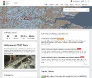
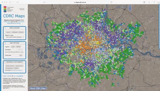
6 New Forms of Access maps.cdrc.ac.uk data.cdrc.ac.uk cdrc.ac.uk
 Alyson Lloyd, UCL Access")
7 Challenging Social Sciences Data cleaning Big Data Infrastructure Raw data Cleaned data 65,770 accounts 53,141 accounts Travel flows from customers origin MSOA to their most frequently visited store (one store type) Alyson Lloyd, UCL Access Techniques


8 Challenging Social Sciences Skills acquisition Programming for Social Sciences University of Leeds Understanding Data and its Environment University of Manchester Analysis of Human Dynamics University of Liverpool Social Analytics & Visualisation University of Sheffield
9 Urban Analytics Examples Retail Dynamics Urban Contexts Geodemographics Applications and Data Fusion e-resilience - regional retail systems Dynamics Sensors


10 Retail Dynamics 2004 Boundaries Long Term (ODPM / DCLG) Defined Town Centres Outdated Not retail specific Pavlis, M, L. Dolgea and A. Singleton (2017). A Modified DBSCAN Clustering Method to Estimate Retail Center Extent. In: Geographical Analysis.
,")
 Les")
11 Retail Dynamics Short Term Grimsby: Centre (red), Convenience (blue), Comparison (Green) Les Dolega, Michail Pavlis


12 Urban Contexts


13 Supermarket Local Shop


14 Sports Injury Heart Problems

15 Urban Contexts bluesquarething/ /
16
17
18
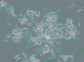
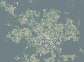
19 A C D E B


.")

20 Manchester Liverpool Gale, C, A. Singleton and P. Longley (2016). Creating the 2011 area classification for output areas (2011 OAC). In: Journal of Spatial Information Science, pp URL:
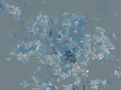
21 Night Day

22 London Classification of Workplace Zones Domain Employment Type Dynamism / Attractiveness Employee Characteristics Job Characteristics Commuting / Connections Residential Context Sub Domain Employment Occupation Types Retail Density Change Night-time Economy Demographic Diversity Socio-economic Qualifications Working day NS-SEC Distance / Accessibility Mode Demography Socio-economic Family structure Education Residential Mix 2011 Census Business Register and Employment Survey Location and type retailers Sensor data
23
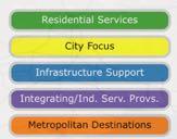
24 Groups & Sub Groups Group A: Residential Services o A1: Predominantly older, local education and health workers o A2: Lowly qualified workers in construction and allied local trades Group B: City Focus o B1: Dynamic financial centres with extended operating hours o B2: Professional, retail and leisure Services in dynamic central locations Group C: Infrastructure Support o C1: Younger customer service workers in wholesale or retail occupations o C2: Blue collar, manufacturing and transport services Group D: Integrating and Independent Service Providers o D1: Health care support staff and routine service occupations o D2 Locally sourced, home helps and domestic or manual workers o D3: Travelling or home-based general service providers Group E: Metropolitan Destinations o E1: High street destinations and domestic employers o E2: Accessible retail, leisure and tourist services

 labour force Source:")
25 B: City Focus These areas bring focus to a range of specialised professional activities and also accommodate more general support services and retail activities. The portfolio of over-all activity may also be catalytic to the occurrence of night-time economies. Workers in all of these activities are predominantly drawn from a core (age 25-39) labour force Source:

26 Group E: Metropolitan Destinations These areas are overwhelmingly located in Inner London and many serve as retail destinations. A very international range of workers provide a wide range of high value and retail services. Many of these workers also reside in central London locations.

27 Integration - Internet & Retail


28

29 Internet User Classification Dean Riddlesden
30 e-resilience Online&sales& Connec?vity& Consumer&Behaviour& Supply&factors& ++infrastructure speed+ rurality+ Retail/Service& Offer& retail/service+mix+ +++a.rac/veness shopping+convenience Retail& e<resilience& Engagement+with+ICT Shopping+online+ + Catchments& &Demographics& socio5economic+status+ age+ + Demand&factors& Vulnerability/adapta?on&


31 e-resilience Singleton, A, L. Dolgea, M. Pavlis and P. Longley (2016). Measuring the spatial vulnerability of retail centres to online consumption through a framework of e-resilience. In: Geoforum 69, pp


32 Integration - Urban Dynamics Smart Street Sensor Minimum of 1000 sensors - UK wide
33 Smart Street Sensor

34 Smart Street Sensor
35 Smart Street Sensor Group Number of sensors A: Residential Services 2 B: City Focus 55 C: Infrastructure Support 39 D: Integrating and Independent Service Providers 10 E: Metropolitan Destinations 90
36 B: City Focus E: Metropolitan Destinations From Work To Work Lunch
37 B: City Focus E: Metropolitan Destinations
38 Conclusions New forms of data offer great opportunities to study the structure and function of cities Future of urban social science Challenges for both access and analysis Urban analytics is interdisciplinary - framework through which we can study cities using new forms of data
")
39 Many thanks 1. Questioning the City through Urban Analytics 2. Sensing the City 3. Urban Data Infrastructure 4. Visualizing the City 5. Differences within Cities 6. Explaining the City 7. Generative Urban Systems 8. Cities as Networks and Flows 9. The Future of Urban Analytics Due out Jan 2018; Singleton, Spielman, Folch (Sage)
Analysis of travel-to-work patterns and the identification and classification of REDZs
 Analysis of travel-to-work patterns and the identification and classification of REDZs Dr David Meredith, Teagasc, Spatial Analysis Unit, Rural Economy Development Programme, Ashtown, Dublin 15. david.meredith@teagasc.ie
Trip Generation Model Development for Albany
 Trip Generation Model Development for Albany Hui (Clare) Yu Department for Planning and Infrastructure Email: hui.yu@dpi.wa.gov.au and Peter Lawrence Department for Planning and Infrastructure Email: lawrence.peter@dpi.wa.gov.au
The geography of domestic energy consumption
 The geography of domestic energy consumption Anastasia Ushakova PhD student at CDRC UCL Ellen Talbot PhD student at CDRC Liverpool Some important research questions How can we classify energy consumption
LEO Catchment Profile (LCP) Key Data for Enterprise Strategy
 Key Data for Enterprise Strategy") Laois...Portarlington LEO Catchment Profile (LCP) Key Data for Enterprise Strategy Laois Local Enterprise Office Address: Business Support Unit, County Hall, Portlaoise, County Laois Web: https://www.localenterprise.ie/laois/
Laois...Portarlington LEO Catchment Profile (LCP) Key Data for Enterprise Strategy Laois Local Enterprise Office Address: Business Support Unit, County Hall, Portlaoise, County Laois Web: https://www.localenterprise.ie/laois/
R E SEARCH HIGHLIGHTS
 Canada Research Chair in Urban Change and Adaptation R E SEARCH HIGHLIGHTS Research Highlight No.8 November 2006 THE IMPACT OF ECONOMIC RESTRUCTURING ON INNER CITY WINNIPEG Introduction This research highlight
PRIMA. Planning for Retailing in Metropolitan Areas
 PRIMA Planning for Retailing in Metropolitan Areas Metropolitan Dimension to sustainable retailing futures Metropolitan strategies Retailing in city and town centres will be a primary component of any
A Modified DBSCAN Clustering Method to Estimate Retail Centre Extent
 A Modified DBSCAN Clustering Method to Estimate Retail Centre Extent Michalis Pavlis 1, Les Dolega 1, Alex Singleton 1 1 University of Liverpool, Department of Geography and Planning, Roxby Building, Liverpool
Measuring connectivity in London
 Measuring connectivity in London OECD, Paris 30 th October 2017 Simon Cooper TfL City Planning 1 Overview TfL Connectivity measures in TfL PTALs Travel time mapping Catchment analysis WebCAT Current and
A national-scale application of the Huff gravity model for the estimation of town centre retail catchment area
 A national-scale application of the Huff gravity model for the estimation of town centre retail catchment area Michail Pavlis, Les Dolega, Alex Singleton Department of Geography and Planning, School of
APPLIED FIELDWORK ENQUIRY SAMPLE ASSESSMENT MATERIALS
 GCSE GEOGRAPHY B Sample Assessment Materials 85 GCSE GEOGRAPHY B COMPONENT 3 APPLIED FIELDWORK ENQUIRY SAMPLE ASSESSMENT MATERIALS 1 hour 30 minutes For examiner s use only SPaG Part A 18 0 Part B 18 0
Declaration Population and culture
 Declaration Population and culture The ministers of the parties to the Alpine Convention regard the socio-economic and socio-cultural aspects mentioned in Article 2, Paragraph 2, Item a., as being central
Application Issues in GIS: the UCL Centre for Advanced Spatial Analysis. Paul Longley UCL
 Application Issues in GIS: the UCL Centre for Advanced Spatial Analysis Paul Longley UCL GIS: inclusive, shared understanding Geodemographics as a focus of interest Profiling public goods and services
REAL-TIME GIS OF GENDER
 2 nd Conference on Advanced Modeling and Analysis MOPT/IGOT/CEG REAL-TIME GIS OF GENDER A telegeomonitoring approach PT07 Mainstreaming Gender Equality and Promoting Work Life Balance (2nd Open Call -
Open Data Sources for Domain Specific Geodemographics
 Open Data Sources for Domain Specific Geodemographics Matthew D. Pratt 1, Paul A. Longley 1, James Cheshire 2, Chris Gale 1 1 Department of Geography, University College London, Gower Street, London, WC1E
The Economic and Social Health of the Cairngorms National Park 2010 Summary
 The Economic and Social Health of the Cairngorms National Park 2010 Published by Cairngorms National Park Authority The Economic and Social Health of the Cairngorms National Park 2010 This summary highlights
Port Cities Conference: How Regional Planning can Help Support a Competitive Port. Christina DeMarco Metro Vancouver
 Port Cities Conference: How Regional Planning can Help Support a Competitive Port Christina DeMarco Metro Vancouver June 12. 2008 Metro Vancouver Regional Growth Management Three ways to help support the
Population 24/7. David Martin, University of Southampton
 Population 24/7 David Martin, University of Southampton Demographics User Group 18 March 2011 Presentation overview Acknowledgement: Samantha Cockings and Samuel Leung; ESRC award RES-062-23-181 Small
22 cities with at least 10 million people See map for cities with red dots
 22 cities with at least 10 million people See map for cities with red dots Seven of these are in LDC s, more in future Fastest growing, high natural increase rates, loss of farming jobs and resulting migration
Regional Snapshot Series: Transportation and Transit. Commuting and Places of Work in the Fraser Valley Regional District
 Regional Snapshot Series: Transportation and Transit Commuting and Places of Work in the Fraser Valley Regional District TABLE OF CONTENTS Complete Communities Daily Trips Live/Work Ratio Commuting Local
Making space for a more foundational construction sector in Brussels
 Making space for a more foundational construction sector in Brussels Sarah De Boeck, David Bassens & Michael Ryckewaert Social innovation in the Foundational Economy Cardiff, 5 th of September 2018 1.
The Analysis of Economic Development and Resilience Dynamics of Medium-Sized Towns
 Master Thesis Student: Ksenija Banovac Thesis supervisor: prof. Abdelillah Hamdouch, University François Rabelais, Tours The Analysis of Economic Development and Resilience Dynamics of Medium-Sized Towns
BROOKINGS May
 Appendix 1. Technical Methodology This study combines detailed data on transit systems, demographics, and employment to determine the accessibility of jobs via transit within and across the country s 100
Exploring the Geography of Access to Fixed Line Broadband Services in England using Crowd Sourced Speed Check Data
 Exploring the Geography of Access to Fixed Line Broadband Services in England using Crowd Sourced Speed Check Data Dean Riddlesden 1, Alex D. Singleton 2 1 Department of Geography and Planning, School
Economic and Resident Baseline
 and LEP Economic and Resident Baseline Appendix Contents of the Appendix 2 and Local Enterprise Partnership (LEP) is reviewing its Strategic Economic Plan (SEP) and has commissioned Metro Dynamics to carry
Economic Geography of the Long Island Region
 Geography of Data Economic Geography of the Long Island Region Copyright 2011 AFG 1 The geography of economic activity requires: - the gathering of spatial data - the location of data geographically -
Entrepreneurship on islands and other peripheral regions. Specific Contract No 6511 implementing Framework contract No CDR/DE/16/2015/
 Entrepreneurship on islands and other peripheral regions Specific Contract No 6511 implementing Framework contract No CDR/DE/16/2015/ Aims of this study: To analyse the particular challenges and obstacles
Healthy Cities. Lecture 4 Planning and Regeneration, Sustainable and Healthy. Opening Address
 Healthy Cities Lecture 4 Planning and Regeneration, Sustainable and Healthy Opening Address Suzanne Wylie Director of Health and Environmental Services, Belfast City Council Belfast The Past The Present
Topic 4: Changing cities
 Topic 4: Changing cities Overview of urban patterns and processes 4.1 Urbanisation is a global process a. Contrasting trends in urbanisation over the last 50 years in different parts of the world (developed,
Profiling Burglary in London using Geodemographics
 Profiling Burglary in London using Geodemographics C G Gale *1, A D Singleton 2 and P A Longley 3 1 UCL Department of Civil, Environmental & Geomatic Engineering 2 University of Liverpool Department of
Creating a Geodemographic Classification
 Creating a Geodemographic Classification Dr Daniel Vickers Department of Geography, University of Sheffield D.Vickers@sheffield.ac.uk www.shef.ac.uk/sasi www.areaclassification.org.uk Why classify areas?
Planning for Economic and Job Growth
 Planning for Economic and Job Growth Mayors Innovation Project Winter 2012 Meeting January 21, 2012 Mary Kay Leonard Initiative for a Competitive Inner City AGENDA The Evolving Model for Urban Economic
PhD in URBAN PLANNING, DESIGN, AND POLICY - 34th cycle
 PhD in URBAN PLANNING, DESIGN, AND POLICY - 34th cycle Research Field: THE MULTIPLE EFFECTS OF B2C E-COMMERCE GROWTH IN ITALY: RETAIL SYSTEM EVOLUTION AND SPATIAL IMPACT. Monthly net income of PhDscholarship
Integrated Infrastructure Planning & Spatial Mapping
 Integrated Infrastructure Planning & Spatial Mapping Presenter: Heidi Dixon, Principal Social Planner, DTPLI 23 May 2014 PART 1 PLAN MELBOURNE : Metropolitan Planning Strategy PART 2 Case Study: DTPLI
Regionalizing and Understanding Commuter Flows: An Open Source Geospatial Approach
 Regionalizing and Understanding Commuter Flows: An Open Source Geospatial Approach Lorraine Barry School of Natural and Built Environment, Queen's University Belfast l.barry@qub.ac.uk January 2017 Summary
Data driven approaches to Urban Planning Experience from Derry/Londonderry
 Data driven approaches to Urban Planning Experience from Derry/Londonderry Anna Rose RTPI Belfast 11 th of September 1 June 26 07:47AM 2 The value of the City The space of the city is a theatre: playing
a) Imbedding flexibility b) Different incentives for different locations? 1. What are we trying to achieve?
 Imbedding flexibility b) Different incentives for different locations? 1. What are we trying to achieve?") 2 1. What are we trying to achieve? a) Growth as fast as possible (spatially neutral) b) Growth as fast as possible, in as many places as possible c) Shift in the pattern of geographic distribution of
2 1. What are we trying to achieve? a) Growth as fast as possible (spatially neutral) b) Growth as fast as possible, in as many places as possible c) Shift in the pattern of geographic distribution of
HORIZON 2030: Land Use & Transportation November 2005
 PROJECTS Land Use An important component of the Horizon transportation planning process involved reviewing the area s comprehensive land use plans to ensure consistency between them and the longrange transportation
An online data and consulting resource of THE UNIVERSITY OF TOLEDO THE JACK FORD URBAN AFFAIRS CENTER
 An online data and consulting resource of THE JACK FORD URBAN AFFAIRS CENTER THE CENTER FOR GEOGRAPHIC INFORMATION SCIENCE AND APPLIED GEOGRAPHICS DEPARTMENT OF GEOGRAPHY AND PLANNING THE UNIVERSITY OF
How Geography Affects Consumer Behaviour The automobile example
 How Geography Affects Consumer Behaviour The automobile example Murtaza Haider, PhD Chuck Chakrapani, Ph.D. We all know that where a consumer lives influences his or her consumption patterns and behaviours.
Chapter 12. Services
 Chapter 12 Services Where di services originate? Key Issue #1 Shoppers in Salzburg, Austria Origins & Types of Services Types of services Consumer services Business services Public services Changes in
A User s Guide to the Federal Statistical Research Data Centers
 A User s Guide to the Federal Statistical Research Data Centers Mark Roberts Professor of Economics and Director PSU FSRDC September 2016 M. Roberts () RDC User s Guide September 2016 1 / 14 Outline Introduction
Chapter 12: Services
 Chapter 12: Services The Cultural Landscape: An Introduction to Human Geography Services Service = any activity that fulfills a human want or need Services are located in settlements Location of services
An Open Source Geodemographic Classification of Small Areas In the Republic of Ireland Chris Brunsdon, Martin Charlton, Jan Rigby
 An Open Source Geodemographic Classification of Small Areas In the Republic of Ireland Chris Brunsdon, Martin Charlton, Jan Rigby National Centre for Geocomputation National University of Ireland, Maynooth
Mapping UK. David Martin, University of Southampton. Open Data Workshop, Nottingham, 21 June 2011
 Mapping UK population over time David Martin, University of Southampton Open Data Workshop, Nottingham, 21 June 2011 Presentation overview Small area spatial population distributions The time dimension
2. What is a settlement? Why do services cluster in settlements?
 Chapter 12: Services Introduction and Case Study (p. 397-399) 1. What is a service? How do LDCs and MDCs differ in regards to the number of workers employed in service- sector jobs? 2. What is a settlement?
Economic Activity Economic A ctivity
 5 Economic Economic Activity Activity ECONOMIC ACTIVITY 5.1 EMPLOYMENT... 5-7 5.1.1 OBJECTIVE... 5-7 5.1.2 POLICIES... 5-7 5.2 PROTECTING THE AREA OF EMPLOYMENT... 5-9 5.2.1 OBJECTIVE... 5-9 5.2.2 POLICIES...
Understanding China Census Data with GIS By Shuming Bao and Susan Haynie China Data Center, University of Michigan
 Understanding China Census Data with GIS By Shuming Bao and Susan Haynie China Data Center, University of Michigan The Census data for China provides comprehensive demographic and business information
Services includes: Intro to Services Central Place Theory Urban Hierarchies
 Services includes: Intro to Services Central Place Theory Urban Hierarchies Introduction Services any activity that fulfills human wants/needs Services are located in settlements therefore our study of
It is clearly necessary to introduce some of the difficulties of defining rural and
 UNIT 2 CHANGING HUMAN ENVIRONMENTS G2 Theme 2 Investigating Settlement Change in MEDCs 2.1 What are the distinctive features of settlements? It is clearly necessary to introduce some of the difficulties
accessibility accessibility by-pass bid-rent curve bridging point administrative centre How easy or difficult a place is to reach.
 accessibility accessibility How easy or difficult a place is to reach. How easy or difficult it is to enter a building. administrative centre bid-rent curve The function of a town which is a centre for
A tale of two cities. John Daley, CEO, Grattan Institute Work and life in cities: City strategy in Australia Melbourne Economic Forum 27 October 2016
 A tale of two cities John Daley, CEO, Grattan Institute Work and life in cities: City strategy in Australia Melbourne Economic Forum 27 October 2016 A tale of two cities Shifts in consumption are driving
Background the Ch. 12
 Ch. 12 -Services Background the Ch. 12 Shopping Mall Sydney, Australia Services: an activity that provides a human want or need in exchange for money Settlement: permanent collection of buildings where
Assessing the impact of seasonal population fluctuation on regional flood risk management
 Assessing the impact of seasonal population fluctuation on regional flood risk management Alan Smith *1, Andy Newing 2, Niall Quinn 3, David Martin 1 and Samantha Cockings 1 1 Geography and Environment,
Land Use in the context of sustainable, smart and inclusive growth
 Land Use in the context of sustainable, smart and inclusive growth François Salgé Ministry of sustainable development France facilitator EUROGI vice president AFIGéO board member 1 Introduction e-content+
Urban Form and Travel Behavior:
 Urban Form and Travel Behavior: Experience from a Nordic Context! Presentation at the World Symposium on Transport and Land Use Research (WSTLUR), July 28, 2011 in Whistler, Canada! Petter Næss! Professor
Abstract. 1 Introduction
 Urban density and car and bus use in Edinburgh Paul Dandy Department of Civil & Transportation Engineering, Napier University, EH10 5DT, United Kingdom EMail: p.dandy@napier.ac.uk Abstract Laissez-faire
Geography. Geography A. Curriculum Planner and Skills Mapping Grid GCSE Version 1 October 2012
 Geography GCSE 2012 Geography A Curriculum Planner and Skills Mapping Grid Version 1 October 2012 www.ocr.org.uk/gcse2012 Year 10 Exam work Controlled Assessment Autumn 1 Autumn 2 Spring 1 Spring 2 Summer
FROM PHYSICAL TO DIGITAL SPACES Exploring space-time mobility through a telegeomonitoring approach
 1 July 2016 Session 7: The potential of open data and big data for territorial information designed to respond to the PT07 Mainstreaming Gender Equality and Promoting Work Life Balance (2nd Open Call -Support
MODULE 1 INTRODUCING THE TOWNSHIP RENEWAL CHALLENGE
 MODULE 1 INTRODUCING THE TOWNSHIP RENEWAL CHALLENGE FOCUS OF THE MODULE Township renewal challenges and developmental outcomes covered in this module: Historical origins of townships and the inherited
Urbanization and Sustainable Development of Cities: A Ready Engine to Promote Economic Growth and Cooperation
 Urbanization and Sustainable Development of Cities: A Ready Engine to Promote Economic Growth and Cooperation Wan Portia Hamzah Institute of Strategic and International Studies (ISIS) Malaysia 10 September
SPACE-TIME ACCESSIBILITY MEASURES FOR EVALUATING MOBILITY-RELATED SOCIAL EXCLUSION OF THE ELDERLY
 SPACE-TIME ACCESSIBILITY MEASURES FOR EVALUATING MOBILITY-RELATED SOCIAL EXCLUSION OF THE ELDERLY Izumiyama, Hiroshi Institute of Environmental Studies, The University of Tokyo, Tokyo, Japan Email: izumiyama@ut.t.u-tokyo.ac.jp
CORRIDORS OF FREEDOM Access Management (Ability) Herman Pienaar: Director City Transformation and Spatial Planning
 Herman Pienaar: Director City Transformation and Spatial Planning") CORRIDORS OF FREEDOM Access Management (Ability) 2016 Herman Pienaar: Director City Transformation and Spatial Planning PLANNING DEVELOPMENT PROCESS RATHER THAN A PLAN CAPITAL INVESTMENT DEVELOPMENT FACILITATION
CORRIDORS OF FREEDOM Access Management (Ability) 2016 Herman Pienaar: Director City Transformation and Spatial Planning PLANNING DEVELOPMENT PROCESS RATHER THAN A PLAN CAPITAL INVESTMENT DEVELOPMENT FACILITATION
Profiling Burglary in London using Geodemographics. Chris Gale 1, Alex Singleton 2, Paul Longley 1
 Profiling Burglary in London using Geodemographics Chris Gale 1, Alex Singleton 2, Paul Longley 1 1 2 Geodemographic Classifications A Geodemographic Classification: Simplifies a large and complex body
National Statistics 2001 Area Classifications
 National Statistics 2001 Area Classifications John Charlton, ONS see http://neighbourhood.statistics.gov.uk areaclassifications@ons.gov.uk Copyright ONS What are the Area Classifications Summarise 2001
Edexcel Geography Advanced Paper 2
 Edexcel Geography Advanced Paper 2 SECTION B: SHAPING PLACES Assessment objectives AO1 Demonstrate knowledge and understanding of places, environments, concepts, processes, interactions and change, at
LINKING GLASGOW AND EDINBURGH THE GLASGOW EDINBURGH COLLABORATION INITIATIVE
 LINKING GLASGOW AND EDINBURGH THE GLASGOW EDINBURGH COLLABORATION INITIATIVE Paul Finch, Richard Cann AECOM Irvine Piczenik Abellio Dominic Walley Connected Economics Limited 1. INTRODUCTION Glasgow and
Council Workshop on Neighbourhoods Thursday, October 4 th, :00 to 4:00 p.m. Burlington Performing Arts Centre
 Council Workshop on Neighbourhoods Thursday, October 4 th, 2012 1:00 to 4:00 p.m. Burlington Performing Arts Centre Agenda Introductions Warm-Up Exercise Presentation Exercise Neighbourhood Planning Break
Using Social Media for Geodemographic Applications
 Using Social Media for Geodemographic Applications Muhammad Adnan and Guy Lansley Department of Geography, University College London @gisandtech @GuyLansley Web: http://www.uncertaintyofidentity.com Outline
Chapter 12. Key Issue Three: Why do business services locate in large settlements?
 Chapter 12 Key Issue Three: Why do business services locate in large settlements? Business Services and Settlements World cities Ancient world cities Medieval world cities Modern world cities Hierarchy
AP Human Geography Unit 7a: Services Guided Reading Mr. Stepek Introduction (Rubenstein p ) 1. What is the tertiary sector of the economy?
 1. What is the tertiary sector of the economy?") Public Business Consumer AP Human Geography Unit 7a: Services Guided Reading Mr. Stepek Introduction (Rubenstein p 372 374) 1. What is the tertiary sector of the economy? 2. What is a service activity?
Public Business Consumer AP Human Geography Unit 7a: Services Guided Reading Mr. Stepek Introduction (Rubenstein p 372 374) 1. What is the tertiary sector of the economy? 2. What is a service activity?
Dublin Chamber submission on Dublin City Development Plan : Outdoor Advertising Strategy
 Dublin Chamber submission on Dublin City Development Plan 2011 2017: Outdoor Advertising Strategy January 2012 Key Points: Sustainable and appropriate advertising can play an important positive role in
MULTIPLE CHOICE. Choose the one alternative that best completes the statement or answers the question.
 AP Test 13 Review Name MULTIPLE CHOICE. Choose the one alternative that best completes the statement or answers the question. 1) Compared to the United States, poor families in European cities are more
A route map to calibrate spatial interaction models from GPS movement data
 A route map to calibrate spatial interaction models from GPS movement data K. Sila-Nowicka 1, A.S. Fotheringham 2 1 Urban Big Data Centre School of Political and Social Sciences University of Glasgow Lilybank
Data Matrix User Guide
 Data Matrix User Guide 1. Introduction The 2017 Data Matrix is designed to support the 2017 iteration of the Regional Skills Assessments (RSAs) in Scotland. The RSAs align with the Regional Outcome Agreement
2012 State of the Region Address. Michael C. Carroll, Ph.D. Center for Regional Development Bowling Green State University
 2012 State of the Region Address Michael C. Carroll, Ph.D. Center for Regional Development Bowling Green State University Outline How we have changed Changing employment trends Temporal view of unemployment
Key Issue 1: Where Are Services Distributed? INTRODUCING SERVICES AND SETTLEMENTS LEARNING OUTCOME DESCRIBE THE THREE TYPES OF SERVICES
 Revised 2017 NAME: PERIOD: Rubenstein: The Cultural Landscape (12 th edition) Chapter Twelve Services and Settlements (pages 430 thru 457) This is the primary means by which you will be taking notes this
East Bay BRT. Planning for Bus Rapid Transit
 East Bay BRT Planning for Bus Rapid Transit Regional Vision Draper Prison The Bottleneck is a State-Level issue, Salt Lake County 2050 Population: 1.5M Draper Prison hopefully with some State-Level funding!
New Partners for Smart Growth: Building Safe, Healthy, and Livable Communities Mayor Jay Williams, Youngstown OH
 New Partners for Smart Growth: Building Safe, Healthy, and Livable Communities Mayor Jay Williams, Youngstown OH The City of Youngstown Youngstown State University Urban Strategies Inc. Youngstown needed
A Comprehensive Method for Identifying Optimal Areas for Supermarket Development. TRF Policy Solutions April 28, 2011
 A Comprehensive Method for Identifying Optimal Areas for Supermarket Development TRF Policy Solutions April 28, 2011 Profile of TRF The Reinvestment Fund builds wealth and opportunity for lowwealth communities
Defining Metropolitan Regions (MRs): coping with complexity
: coping with complexity") OECD Paris 27 November 2006 Defining Metropolitan Regions (MRs): coping with complexity Mike Coombes CURDS Newcastle University Britain Acknowledgements CURDS colleagues eg. Simon Raybould Past sponsors
OECD Paris 27 November 2006 Defining Metropolitan Regions (MRs): coping with complexity Mike Coombes CURDS Newcastle University Britain Acknowledgements CURDS colleagues eg. Simon Raybould Past sponsors
Too Close for Comfort
 Too Close for Comfort Overview South Carolina consists of urban, suburban, and rural communities. Students will utilize maps to label and describe the different land use classifications. Connection to
MOR CO Analysis of future residential and mobility costs for private households in Munich Region
 MOR CO Analysis of future residential and mobility costs for private households in Munich Region The amount of the household budget spent on mobility is rising dramatically. While residential costs can
Summary and Implications for Policy
 Summary and Implications for Policy 1 Introduction This is the report on a background study for the National Spatial Strategy (NSS) regarding the Irish Rural Structure. The main objective of the study
A Review of Concept of Peri-urban Area & Its Identification
 A Review of Concept of Peri-urban Area & Its Identification Ar. Manita Saxena Research Scholar Department of Architecture and Planning M.A.N.I.T, Bhopal Dr. Supriya Vyas Assistant Professor, Department
Vital city lively neighborhood living center
 From the ugliest place to heart of the suburb Vital city lively neighborhood living center Marja Straver - Nevalainen September 12 th, 2012 If you want to see the sun, t th look next to it to NL FI 10x
Chapter 11 Conclusions
 Chapter 11 Conclusions Economic Linkages 11.1 The review of evidence suggests that the Leicester and Leicestershire sub-region represents a sensible functional economic geography for an economic assessment.
GCSE 4241/02 GEOGRAPHY (Specification B) HIGHER TIER UNIT 1
 HIGHER TIER UNIT 1") Surname Centre Number Candidate Number Other Names 0 GCSE 4241/02 GEOGRAPHY (Specification B) HIGHER TIER UNIT 1 S15-4241-02 P.M. TUESDAY, 19 May 2015 1 hour For s use Question Maximum Mark Mark Awarded
Surname Centre Number Candidate Number Other Names 0 GCSE 4241/02 GEOGRAPHY (Specification B) HIGHER TIER UNIT 1 S15-4241-02 P.M. TUESDAY, 19 May 2015 1 hour For s use Question Maximum Mark Mark Awarded
Victorian Liveability Indicator Program: Definition, Measurement and Application
 Victorian Liveability Indicator Program: Definition, Measurement and Application Dr Hannah Badland Senior Research Fellow Place, Health, and Liveability Program Melbourne School of Population and Global
Are You Maximizing The Value Of All Your Data?
 Are You Maximizing The Value Of All Your Data? Using The SAS Bridge for ESRI With ArcGIS Business Analyst In A Retail Market Analysis SAS and ESRI: Bringing GIS Mapping and SAS Data Together Presented
Mapping Welsh Neighbourhood Types. Dr Scott Orford Wales Institute for Social and Economic Research, Data and Methods WISERD
 Mapping Welsh Neighbourhood Types Dr Scott Orford Wales Institute for Social and Economic Research, Data and Methods WISERD orfords@cardiff.ac.uk WISERD Established in 2008 and funded by the ESRC and HEFCW
c. What is the most distinctive above ground result of high land costs and intensive land use? i. Describe the vertical geography of a skyscraper?
 AP Human Geography Unit 7b Guided Reading: Urban Patterns and Social Issues Mr. Stepek Key Issue #1: Why Do Services Cluster Downtown? (Rubenstein p 404 410) 1. What is the CBD? What does it contain and
6 th GLOBAL SUMMIT ON URBAN TOURISM 4 6 December 2017, Kuala Lumpur (Malaysia)
") 6 th GLOBAL SUMMIT ON URBAN TOURISM 4 6 December 2017, Kuala Lumpur (Malaysia) SUMMARY/CONCLUSIONS Esencan TERZIBASOGLU Director Destination Management and Quality eterzibasoglu@unwto.org 6TH GLOBAL SUMMIT
6 th GLOBAL SUMMIT ON URBAN TOURISM 4 6 December 2017, Kuala Lumpur (Malaysia) SUMMARY/CONCLUSIONS Esencan TERZIBASOGLU Director Destination Management and Quality eterzibasoglu@unwto.org 6TH GLOBAL SUMMIT
The Mayor s Outer London Commission: Final Report
 The Mayor s Outer London Commission: Final Report Purpose of the Outer London Commission find out the extent to which outer London has potential to contribute to the economic success of London as a whole,
Social Studies Grade 2 - Building a Society
 Social Studies Grade 2 - Building a Society Description The second grade curriculum provides students with a broad view of the political units around them, specifically their town, state, and country.
Climate Risk Visualization for Adaptation Planning and Emergency Response
 Climate Risk Visualization for Adaptation Planning and Emergency Response NCR Flood Fact Finding Workshop Ricardo Saavedra ricardo@vizonomy.com Social Media, Mobile, and Big Data St. Peter s Basilica,
GCSE 4232/02 GEOGRAPHY. (Specification A) HIGHER TIER UNIT 2 Options Geography. A.M. FRIDAY, 17 June hour 15 minutes.
 HIGHER TIER UNIT 2 Options Geography. A.M. FRIDAY, 17 June hour 15 minutes.") Candidate Name Centre Number 0 Candidate Number GCSE 4232/02 GEOGRAPHY (Specification A) HIGHER TIER UNIT 2 Options Geography A.M. FRIDAY, 17 June 2011 1 hour 15 minutes Section A Section B For s Use Only
Candidate Name Centre Number 0 Candidate Number GCSE 4232/02 GEOGRAPHY (Specification A) HIGHER TIER UNIT 2 Options Geography A.M. FRIDAY, 17 June 2011 1 hour 15 minutes Section A Section B For s Use Only
HSC Geography. Year 2013 Mark Pages 10 Published Jul 4, Urban Dynamics. By James (97.9 ATAR)
") HSC Geography Year 2013 Mark 92.00 Pages 10 Published Jul 4, 2017 Urban Dynamics By James (97.9 ATAR) Powered by TCPDF (www.tcpdf.org) Your notes author, James. James achieved an ATAR of 97.9 in 2013 while
HSC Geography Year 2013 Mark 92.00 Pages 10 Published Jul 4, 2017 Urban Dynamics By James (97.9 ATAR) Powered by TCPDF (www.tcpdf.org) Your notes author, James. James achieved an ATAR of 97.9 in 2013 while
Size matters: issues and challenges of local development with a special focus on small and medium sized towns in Czechia
 Size matters: issues and challenges of local development with a special focus on small and medium sized towns in Czechia Luděk Sýkora Charles University, Faculty of Science Dept. of Social Geography and
Alluvium Consulting Australia Senior integrated water management specialist Position Description March 2018
 Alluvium Consulting Australia Senior integrated water management specialist Position Description March 2018 Overview of Alluvium We are an employee-owned consulting firm founded in 2006 to provide advice
Towards a City Model for Heritage-Led Regeneration and Tourism Development
 Towards a City Model for Heritage-Led Regeneration and Tourism Development Brian Smith, Secretary General European Association of Historic Towns and Regions Summary of Presentation Objective Background