Application Issues in GIS: the UCL Centre for Advanced Spatial Analysis. Paul Longley UCL
|
|
|
- Ophelia Daniel
- 5 years ago
- Views:
Transcription

1 Application Issues in GIS: the UCL Centre for Advanced Spatial Analysis Paul Longley UCL
2
3 GIS: inclusive, shared understanding Geodemographics as a focus of interest Profiling public goods and services Geo-genealogy and ethnic profiling Accountability: the E-Society and PPGIS Prospects Profiling and serving bespoke classifications
4 Context: (1) the Google generation Search engines, data assembly and the practice of science Google Earth and Maps as nascent media for spatial information exchange

5 - 30K Developer Sites in first 12 months using Google Maps API - 51 million independent web mentions of Google Map API - 130K Blog Posts in first 12 months mentioning Google Maps - 1 billion installs (downloads?) in first 12 months Google Earth - 67cm resolution satellite photos for 30% of Earth's population -Michael Jones (Google Chief Technical Officer) Search Term Google Map Source:

6

7 Context: (2) Geodemographics geodemographic indicators small area measures of social, economic and demographic conditions scale neighbourhoods as aggregations of unit postcodes

8
9 A tried and tested technology, with academic roots Park, Burgess and the urban ecology of 1920s Chicago Business applications Supplementation of framework data with lifestyles Attributes, Scale, Refresh Developments in data collection, availability, handling technology. Empowerment The drive towards bespoke classifications

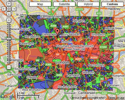
10 Newcastle : Jesmond ward Mosaic by Postcode Twilight Subsistence Municipal Dependency Welfare Borderline University Challenge Town Gown Transition Victorian Villas Settled Minorities
 Welfare")
11 Who are geographers? Symbols of Success Index Score (Base 100) Welfare Borderline UCAS Preferred Applications


12 Too Many Too Few

13 Other public goods and services
14 Command and Control approach Cabinet Office, HM Treasury; PSAs Home Office; KPIs Legislation Audit / Inspection Governance Partnerships: UA, LA, BCU, CDRP, LSP, PCT Neighbourhood service provision Central Government GOs Local Authorities Wards Top down Real communities Assumes homogeneity
15 Neighbourhoods approach Cabinet Office, HM Treasury; PSAs Home Office; KPIs Central Government Legislation Audit / Inspection Governance Partnerships: UA, LA, BCU, CDRP, LSP, PCT Neighbourhood service provision GOs Local Authorities Wards Geodemographics Real communities Acknowledges heterogeneity Bottom up
16 The public private sector dilemma Scientific reproducibility, data sources, black boxes, weighting Accountability and feedback Private versus public goods Creation of data at the local level, e.g. the Census and the Electoral Roll
17
18 Geographical Location Frequency & Ethnicity

19
20
21


22
23 1 st Month 355k unique users Maximum Daily Peak June - 210k unique users Extensive feedback - over 600 s

24 ~150k Unique Daily Users ~210k Unique Daily Users
25
26
27

28

29

30

31

32

33
34 Bespoke classifications: the E-Society and PPGIS
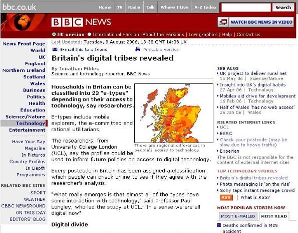
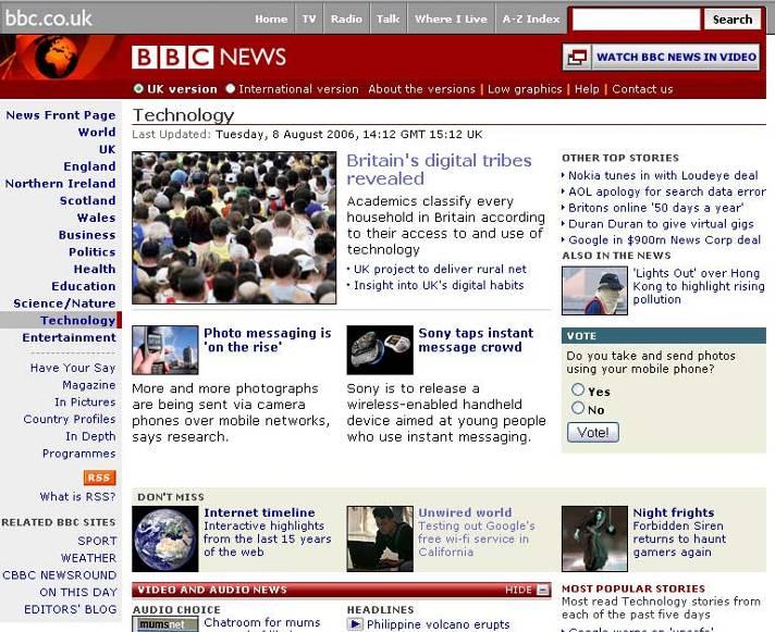
35 1990s digital divides digital haves digital have-nots Radically changing With a population increasingly on-line, most people in the UK now have access to some digital technology, either through devices that they own or through usage in public places today s digital differentiation in access to different types of goods and services speed and convenience of access access to new technologies in public and private domains
36 A nationwide classification access to information, pertaining to private and public goods transactions concerning private goods participation in decision making and collective consumption Nationwide typology and areal profiling of use and access to digital technologies


37 Group C : Becoming engaged Members of this Group often acquire their competence in the use of information technology at work, since many of them are young people working in junior white collar occupations in modern offices. They are keen to become more expert in the use of new technologies and to use them for new applications. Many spend time browsing the Internet but without necessarily making many transactions. Many members of this Group work in large cities and may be starting a life in a house that they own, typically in one of the cheaper inner suburbs. Their use of the Internet at work may be a practice that their employers may be keen to control or reduce.
38


39 Similarity Similarity Chart Location Map Location Map SE6 4XD = District Level (SE6)
40 A simple research/evaluation methodology Motivations: Evaluate (breakdown of usage) Validate (ancillary sources and feedback) Keep record of searches (88,272) and responses received (4,041) 15 th Sept 2006 Option to correct our model Wider implications, e.g. bespoke versus general purpose classifiers


41 Where is the E-Society?
42 Postcode Search Propensity by e-society Types Index (Base 100) Group A : E-unengaged Group B : E-marginalised Group C : Becoming engaged Group D : E for entertainment & shopping Group E : E-independents Group F : Instrumental E-users Group G : E-business users Group H : E- experts
43 Postcode Search Propensity by Mosaic Types Index Score (Base 100) Symbols of Success Happy Families Suburban Comfort Ties of Community Urban Intelligence Welfare Borderline Municipal Dependency Blue Collar Enterprise Tw ilight Subsistence Grey Perspectives Rural Isolation 50 0
44 Old etype = A01 A01 A02 A03 A04 A05 A06 B07 B08 B09 C10 C11 D12 D13 E14 E15 E16 F17 F18 F19 F20 G21 H22 H23 etypes A B C D E F G H Feedback Frequency
45 Data quality? A01 A02 A03 A04 A05 A06 B07 B08 B09 C10 C11 D12 D13 E14 E15 E16 F17 F18 F19 F20 G21 H22 H23 Global Connections Cultural Leadership Corporate Chieftains Golden Empty Nesters Provincial Privilege High Technologists Semi-Rural Seclusion
46 Some Prospects Profiling and serving bespoke classifications
47


48

49 OAC London (Super Output Areas) The OAC classification shown here was created using a tool developed at UCL which takes a shapefile and creates a fully working Google Maps website. The aim is to allow hosting and searching of map data.

50 OAC Nottingham (Super Output Areas) The OAC classification for the Midlands Area. The map is currently centred on Nottingham.

51

52 Google Earth: 3D London

53


54 Geography Matters
55 Geography Matters
56

57 Geography Matters
58
59
Profiling Burglary in London using Geodemographics. Chris Gale 1, Alex Singleton 2, Paul Longley 1
 Profiling Burglary in London using Geodemographics Chris Gale 1, Alex Singleton 2, Paul Longley 1 1 2 Geodemographic Classifications A Geodemographic Classification: Simplifies a large and complex body
The geography of domestic energy consumption
 The geography of domestic energy consumption Anastasia Ushakova PhD student at CDRC UCL Ellen Talbot PhD student at CDRC Liverpool Some important research questions How can we classify energy consumption
Understanding Your Community A Guide to Data
 Understanding Your Community A Guide to Data Alex Lea September 2013 Research and Insight Team LeicestershireCounty Council Understanding Geographies Important to understand the various geographies that
Demographic Data in ArcGIS. Harry J. Moore IV
 Demographic Data in ArcGIS Harry J. Moore IV Outline What is demographic data? Esri Demographic data - Real world examples with GIS - Redistricting - Emergency Preparedness - Economic Development Next
Profiling Burglary in London using Geodemographics
 Profiling Burglary in London using Geodemographics C G Gale *1, A D Singleton 2 and P A Longley 3 1 UCL Department of Civil, Environmental & Geomatic Engineering 2 University of Liverpool Department of
Topic 4: Changing cities
 Topic 4: Changing cities Overview of urban patterns and processes 4.1 Urbanisation is a global process a. Contrasting trends in urbanisation over the last 50 years in different parts of the world (developed,
It is clearly necessary to introduce some of the difficulties of defining rural and
 UNIT 2 CHANGING HUMAN ENVIRONMENTS G2 Theme 2 Investigating Settlement Change in MEDCs 2.1 What are the distinctive features of settlements? It is clearly necessary to introduce some of the difficulties
Advances in Geographic Data Science and Urban Analytics
 Advances in Geographic Data Science and Urban Analytics Alex Singleton Professor of Geographic Information Science Department of Geography and Planning Consumer Data Research Centre www.cdrc.ac.uk www.geographicdatascience.com
Using Social Media for Geodemographic Applications
 Using Social Media for Geodemographic Applications Muhammad Adnan and Guy Lansley Department of Geography, University College London @gisandtech @GuyLansley Web: http://www.uncertaintyofidentity.com Outline
Open Data Sources for Domain Specific Geodemographics
 Open Data Sources for Domain Specific Geodemographics Matthew D. Pratt 1, Paul A. Longley 1, James Cheshire 2, Chris Gale 1 1 Department of Geography, University College London, Gower Street, London, WC1E
Exploring Digital Welfare data using GeoTools and Grids
 Exploring Digital Welfare data using GeoTools and Grids Hodkinson, S.N., Turner, A.G.D. School of Geography, University of Leeds June 20, 2014 Summary As part of the Digital Welfare project [1] a Java
Measuring connectivity in London
 Measuring connectivity in London OECD, Paris 30 th October 2017 Simon Cooper TfL City Planning 1 Overview TfL Connectivity measures in TfL PTALs Travel time mapping Catchment analysis WebCAT Current and
Council Workshop on Neighbourhoods Thursday, October 4 th, :00 to 4:00 p.m. Burlington Performing Arts Centre
 Council Workshop on Neighbourhoods Thursday, October 4 th, 2012 1:00 to 4:00 p.m. Burlington Performing Arts Centre Agenda Introductions Warm-Up Exercise Presentation Exercise Neighbourhood Planning Break
Spatial Organization of Data and Data Extraction from Maptitude
 Spatial Organization of Data and Data Extraction from Maptitude N. P. Taliceo Geospatial Information Sciences The University of Texas at Dallas UT Dallas GIS Workshop Richardson, TX March 30 31, 2018 1/
Looking at Communities: Comparing Urban and Rural Neighborhoods
 Looking at Communities: Comparing Urban and Rural Neighborhoods OVERVIEW & OBJECTIVES Our urban areas have become so dominant that frequently the children we teach have no connection with and very few
Creating a Geodemographic Classification
 Creating a Geodemographic Classification Dr Daniel Vickers Department of Geography, University of Sheffield D.Vickers@sheffield.ac.uk www.shef.ac.uk/sasi www.areaclassification.org.uk Why classify areas?
The Kenton County School District A System of Excellence Social Studies 4.1 Core Content for Assessment
 Big Idea: Government and Civics The study of government and civics allows students to understand the nature of government and the unique characteristics of American democracy, including its fundamental
Mapping Welsh Neighbourhood Types. Dr Scott Orford Wales Institute for Social and Economic Research, Data and Methods WISERD
 Mapping Welsh Neighbourhood Types Dr Scott Orford Wales Institute for Social and Economic Research, Data and Methods WISERD orfords@cardiff.ac.uk WISERD Established in 2008 and funded by the ESRC and HEFCW
What are we like? Population characteristics from UK censuses. Justin Hayes & Richard Wiseman UK Data Service Census Support
 What are we like? Population characteristics from UK censuses Justin Hayes & Richard Wiseman UK Data Service Census Support Who are we? Richard Wiseman UK Data Service / Jisc Justin Hayes UK Data Service
Department of Economic and Social Affairs May 2007
 UNITED NATIONS SECRETARIAT ESA/STAT/AC.115/13 Department of Economic and Social Affairs May 2007 Statistics Division English only United Nations Expert Group Meeting on Contemporary Practices in Census
GEOGRAPHIC INFORMATION SYSTEMS Session 8
 GEOGRAPHIC INFORMATION SYSTEMS Session 8 Introduction Geography underpins all activities associated with a census Census geography is essential to plan and manage fieldwork as well as to report results
Diverse Places 3 days
 AS Level Geography Edexcel Diverse Places 3 days Deliver two days of fieldwork within a dynamic human environment and cover the recommended themes in depth. Fieldwork in these locations provides a contrast
Welcome to GCSE Geography. Where will it take us today?
 Welcome to GCSE Geography Where will it take us today? Urban Futures Dynamic Development Resource Reliance UK in the 21 st Century Global Hazards Changing Climate Distinctive Landscapes Sustaining Ecosystems
Fuzzy Geographically Weighted Clustering
 Fuzzy Geographically Weighted Clustering G. A. Mason 1, R. D. Jacobson 2 1 University of Calgary, Dept. of Geography 2500 University Drive NW Calgary, AB, T2N 1N4 Telephone: +1 403 210 9723 Fax: +1 403
Analysis of travel-to-work patterns and the identification and classification of REDZs
 Analysis of travel-to-work patterns and the identification and classification of REDZs Dr David Meredith, Teagasc, Spatial Analysis Unit, Rural Economy Development Programme, Ashtown, Dublin 15. david.meredith@teagasc.ie
People and Society 3 days
 GCSE Geography OCR B People and Society 3 days In-depth coverage of fieldwork within a human environment, enabling students to get the grades they want within section B of the paper 2 exam: Human Geography
Integrating Official Statistics and Geospatial Information NBS Experience
 Integrating Official Statistics and Geospatial Information NBS Experience Presented by Eng. Reda AL Sabbagh Director of IT Dept. Prepared by Eng. Adham Makky GIS Specialist Topics to be covered: Background
LEO Catchment Profile (LCP) Key Data for Enterprise Strategy
 Key Data for Enterprise Strategy") Laois...Portarlington LEO Catchment Profile (LCP) Key Data for Enterprise Strategy Laois Local Enterprise Office Address: Business Support Unit, County Hall, Portlaoise, County Laois Web: https://www.localenterprise.ie/laois/
Laois...Portarlington LEO Catchment Profile (LCP) Key Data for Enterprise Strategy Laois Local Enterprise Office Address: Business Support Unit, County Hall, Portlaoise, County Laois Web: https://www.localenterprise.ie/laois/
British Household Panel Survey, waves 1-17 ( )
") UK Data Archive Study Number 6032 - British Household Panel Survey, Waves 1-17, 1991-2008: Conditional Access, Rural-Urban s British Household Panel Survey, waves 1-17 (1991-2008) User Documentation: Rural-Urban
UK Data Archive Study Number 6032 - British Household Panel Survey, Waves 1-17, 1991-2008: Conditional Access, Rural-Urban s British Household Panel Survey, waves 1-17 (1991-2008) User Documentation: Rural-Urban
Preparing the GEOGRAPHY for the 2011 Population Census of South Africa
 Preparing the GEOGRAPHY for the 2011 Population Census of South Africa Sharthi Laldaparsad Statistics South Africa; E-mail: sharthil@statssa.gov.za Abstract: Statistics South Africa (Stats SA) s Geography
Understanding and accessing 2011 census aggregate data
 Understanding and accessing 2011 census aggregate data 4 July 11:00 to 16:00 BST Justin Hayes and Richard Wiseman UK Data Service Census Support UK censuses provide an unparalleled resource of high quality
An Open Source Geodemographic Classification of Small Areas In the Republic of Ireland Chris Brunsdon, Martin Charlton, Jan Rigby
 An Open Source Geodemographic Classification of Small Areas In the Republic of Ireland Chris Brunsdon, Martin Charlton, Jan Rigby National Centre for Geocomputation National University of Ireland, Maynooth
Population health across space & time: geographical harmonisation of the ONS Longitudinal Study for England & Wales
 British Society for Population Studies Annual Conference, York, September 2011 Population health across space & time: geographical harmonisation of the ONS Longitudinal Study for England & Wales Paul Norman
Millennium Cohort Study:
 Millennium Cohort Study: Geographic Identifiers in MCS June 2009 Jon Johnson Centre for Longitudinal Studies Faculty of Policy and Society Institute of Education, University of London Page 1 Introduction
Rural Pennsylvania: Where Is It Anyway? A Compendium of the Definitions of Rural and Rationale for Their Use
 Rural Pennsylvania: Where Is It Anyway? A Compendium of the Definitions of Rural and Rationale for Their Use Pennsylvania Office of Rural Health 310 Nursing Sciences Building University Park, PA 16802
Vital city lively neighborhood living center
 From the ugliest place to heart of the suburb Vital city lively neighborhood living center Marja Straver - Nevalainen September 12 th, 2012 If you want to see the sun, t th look next to it to NL FI 10x
Operational Definitions of Urban, Rural and Urban Agglomeration for Monitoring Human Settlements
 Operational Definitions of Urban, Rural and Urban Agglomeration for Monitoring Human Settlements By Markandey Rai United Nations Human Settlements Programme PO Box-30030 Nairobi, Kenya Abstract The United
Visualisation of Uncertainty in a Geodemographic Classifier
 Visualisation of Uncertainty in a Geodemographic Classifier Aidan Slingsby 1, Nicholas J. Tate 2, and Peter F. Fisher 2 1 gicentre, Department of Computer Science, City University London, Northampton Square,
Summary and Implications for Policy
 Summary and Implications for Policy 1 Introduction This is the report on a background study for the National Spatial Strategy (NSS) regarding the Irish Rural Structure. The main objective of the study
HSC Geography. Year 2013 Mark Pages 10 Published Jul 4, Urban Dynamics. By James (97.9 ATAR)
") HSC Geography Year 2013 Mark 92.00 Pages 10 Published Jul 4, 2017 Urban Dynamics By James (97.9 ATAR) Powered by TCPDF (www.tcpdf.org) Your notes author, James. James achieved an ATAR of 97.9 in 2013 while
HSC Geography Year 2013 Mark 92.00 Pages 10 Published Jul 4, 2017 Urban Dynamics By James (97.9 ATAR) Powered by TCPDF (www.tcpdf.org) Your notes author, James. James achieved an ATAR of 97.9 in 2013 while
ESTABLISHMENT OF KARNATAKA GEOPORTAL AND ITS ROLE IN PLANNING
 ESTABLISHMENT OF KARNATAKA GEOPORTAL AND ITS ROLE IN PLANNING By H. Hemanth Kumar Karnataka State Council for Science & Technology (KSCST), Indian Institute of Science, Bangalore, India Abstract Natural
Too Close for Comfort
 Too Close for Comfort Overview South Carolina consists of urban, suburban, and rural communities. Students will utilize maps to label and describe the different land use classifications. Connection to
Spatial multicriteria analysis for home buyers
 Spatial multicriteria analysis for home buyers Xavier Albacete University of Eastern Finland, Department of Environmental Science, Research Group of Environmental Informatics, Yliopistoranta 1 E, P.O.
Cultural Data in Planning and Economic Development. Chris Dwyer, RMC Research Sponsor: Rockefeller Foundation
 Cultural Data in Planning and Economic Development Chris Dwyer, RMC Research Sponsor: Rockefeller Foundation A Decade of Attempts to Quantify Arts and Culture Economic impact studies Community indicators
The Building Blocks of the City: Points, Lines and Polygons
 The Building Blocks of the City: Points, Lines and Polygons Andrew Crooks Centre For Advanced Spatial Analysis andrew.crooks@ucl.ac.uk www.gisagents.blogspot.com Introduction Why use ABM for Residential
2011 Oracle Spatial Excellence Awards Presentation
 2011 Oracle Spatial Excellence Awards Presentation May 19, 2011 Ronald Reagan Building and International Trade Center Washington, DC USA Thanks to our sponsors Media Sponsor Media Participants Media Sponsor
SA Geospatial Analysis Platform (GAP) Methodology*, collaborators & data sources
 Methodology*, collaborators & data sources") SA Geospatial Analysis Platform (GAP) Methodology*, collaborators & data sources Mesoframe CSIR, dti, the Presidency & GTZ Demarcation of South Africa into a grid of 50 Km 2 mesozones, nested within important
SA Geospatial Analysis Platform (GAP) Methodology*, collaborators & data sources Mesoframe CSIR, dti, the Presidency & GTZ Demarcation of South Africa into a grid of 50 Km 2 mesozones, nested within important
Land Use in the context of sustainable, smart and inclusive growth
 Land Use in the context of sustainable, smart and inclusive growth François Salgé Ministry of sustainable development France facilitator EUROGI vice president AFIGéO board member 1 Introduction e-content+
Exploring the Geography of Access to Fixed Line Broadband Services in England using Crowd Sourced Speed Check Data
 Exploring the Geography of Access to Fixed Line Broadband Services in England using Crowd Sourced Speed Check Data Dean Riddlesden 1, Alex D. Singleton 2 1 Department of Geography and Planning, School
Unit No-1&2. Settlement Geography
 Unit No-1&2 Settlement Geography TYPES OF SETTLEMENTS Rural Settlements - agriculture as the predominant occupation. Urban settlements - principal industries are secondary and tertiary. Rural Settlement:
2016 New Ward Boundaries Guidance on calculating statistics for the new 2016 wards
 2016 New Ward Boundaries Page 1 Performance, Information and Intelligence 2016 New Ward Boundaries Guidance on calculating statistics for the new 2016 wards Briefing Note Version 2 - March 2016 2016 New
RESIDENTIAL SATISFACTION IN THE CHANGING URBAN FORM IN ADELAIDE: A COMPARATIVE ANALYSIS OF MAWSON LAKES AND CRAIGBURN FARM, SOUTH AUSTRALIA
 RESIDENTIAL SATISFACTION IN THE CHANGING URBAN FORM IN ADELAIDE: A COMPARATIVE ANALYSIS OF MAWSON LAKES AND CRAIGBURN FARM, SOUTH AUSTRALIA by Michael Chadbourne BEPM (Hons) University of Adelaide Thesis
AS Population Change Question spotting
 AS Change Question spotting Changing rate of growth How the rate of growth has changed over the last 100 years Explain the reasons for these changes Describe global or national distribution. Study the
Geographical Inequalities and Population Change in Britain,
 Geographical Inequalities and Population Change in Britain, 1971-2011 Chris Lloyd, Nick Bearman, Gemma Catney Centre for Spatial Demographics Research, University of Liverpool, UK Email: c.d.lloyd@liverpool.ac.uk
Urban White Paper on Tokyo Metropolis 2002
 Urban White Paper on Tokyo Metropolis 2002 By Bureau of City Planning Tokyo Metropolitan Government Part I. "Progress in IT and City Building" Effects of computer networks on cities and cities' response
Sample assessment task. Task details. Content description. Year level 7
 Sample assessment task Year level 7 Learning area Subject Title of task Task details Description of task Type of assessment Purpose of assessment Assessment strategy Evidence to be collected Suggested
LOUISIANA STUDENT STANDARDS FOR SOCIAL STUDIES THAT CORRELATE WITH A FIELD TRIP TO DESTREHAN PLANTATION KINDERGARTEN
 LOUISIANA STUDENT STANDARDS FOR SOCIAL STUDIES THAT CORRELATE WITH A FIELD TRIP TO DESTREHAN PLANTATION KINDERGARTEN Standard 2 Historical Thinking Skills Students distinguish between events, people, and
BROOKINGS May
 Appendix 1. Technical Methodology This study combines detailed data on transit systems, demographics, and employment to determine the accessibility of jobs via transit within and across the country s 100
Exploring GIS Potential for Northwestern Ontario Land Information Ontario
 Exploring GIS Potential for Northwestern Ontario Land Information Ontario May 13, 2015 The LIO Vision LIO Vision: That all geographic information about Ontario is fully integrated and accessible LIO Goal:
Oman NSDI Supporting Economic Development. Saud Al-Nofli Director of Spatial Data Directorate General of NSDI, NCSI
 Oman NSDI Supporting Economic Development 2017 Saud Al-Nofli Director of Spatial Data Directorate General of NSDI, NCSI "It s critical to make correct decisions the first time to optimize the Investments
COSTA RICA Limon City-Port Project
 COSTA RICA Limon City-Port Project 2008 2013 photos by Stefania Abakerli Stefania Abakerli Cecilia Corvalan Context Costa Rica Well-known tourist destination in CA (8.4% GDP) Long tradition of political
SDI Developments in the World s Currently Existing Mega Cities
 SDI Developments in the World s Currently Existing Mega Cities Silke Boos and Hartmut Müller FIG Working Week 2009 Surveyors Key Role in Accelerated Development, Eilat, Israel, 3-8 May 2009 TS 1B SDI in
URBAN CHANGE DETECTION OF LAHORE (PAKISTAN) USING A TIME SERIES OF SATELLITE IMAGES SINCE 1972
 USING A TIME SERIES OF SATELLITE IMAGES SINCE 1972") URBAN CHANGE DETECTION OF LAHORE (PAKISTAN) USING A TIME SERIES OF SATELLITE IMAGES SINCE 1972 Omar Riaz Department of Earth Sciences, University of Sargodha, Sargodha, PAKISTAN. omarriazpk@gmail.com ABSTRACT
URBAN CHANGE DETECTION OF LAHORE (PAKISTAN) USING A TIME SERIES OF SATELLITE IMAGES SINCE 1972 Omar Riaz Department of Earth Sciences, University of Sargodha, Sargodha, PAKISTAN. omarriazpk@gmail.com ABSTRACT
Provision of Web-Based Childcare Support Maps by Local Governments in Japan
 Provision of Web-Based Childcare Support Maps by Local Governments in Japan Mikoto Kukimoto*, Yoshiki Wakabayashi** * Nara Women s University ** Tokyo Metropolitan University Abstract. The aim of this
A Guide to Census Geography
 Research Briefing 2013-05 July 2013 A Guide to Census Geography Contents 1 About this Briefing... 3 2 Sub Ward Geography... 3 3 The Geographical Hierarchies... 3 4 The Statistical Hierarchy... 4 5 Nesting...
The History Behind Census Geography
 The History Behind Census Geography Michael Ratcliffe Geography Division US Census Bureau Tennessee State Data Center August 8, 2017 Today s Presentation A brief look at the history behind some of the
2016 New Ward Boundaries Guidance on calculating statistics for the new 2016 wards
 2016 New Ward Boundaries Page 1 Performance, Information and Intelligence 2016 New Ward Boundaries Guidance on calculating statistics for the new 2016 wards Briefing Note February 2016 2016 New Ward Boundaries
Combining Geospatial and Statistical Data for Analysis & Dissemination
 Combining Geospatial and Statistical Data for Analysis & Dissemination (with Special Reference to Qatar Census 2010) Presentation by Mansoor Al Malki, Director of IT Department Qatar Statistics Authority
Voices from Private Sector: Insights for Future NSDI Development in Indonesia
 Voices from Private Sector: Insights for Future NSDI Development in Indonesia Ta n d a n g Yu l i a d i D w i P u t ra, Ryosuke S h i b a s a k i I n st i t u t e o f I n d u st r i a l S c i e n c e,
Advanced Placement Human Geography
 Advanced Placement Human Geography Introduction to AP Human Geography The Advanced Placement course in Human Geography is designed to introduce students to the systematic study of the processes that have
Methodological issues in the development of accessibility measures to services: challenges and possible solutions in the Canadian context
 Methodological issues in the development of accessibility measures to services: challenges and possible solutions in the Canadian context Alessandro Alasia 1, Frédéric Bédard 2, and Julie Bélanger 1 (1)
Understanding China Census Data with GIS By Shuming Bao and Susan Haynie China Data Center, University of Michigan
 Understanding China Census Data with GIS By Shuming Bao and Susan Haynie China Data Center, University of Michigan The Census data for China provides comprehensive demographic and business information
Rural Gentrification: Middle Class Migration from Urban to Rural Areas. Sevinç Bahar YENIGÜL
 'New Ideas and New Generations of Regional Policy in Eastern Europe' International Conference 7-8 th of April 2016, Pecs, Hungary Rural Gentrification: Middle Class Migration from Urban to Rural Areas
Economic Development and Transport in New Zealand. Thomas Simonson 4/7/2016
 Economic Development and Transport in New Zealand Thomas Simonson 4/7/2016 Definitions > Economics is about people and communities, and the skills, equipment and resources they acquire to pursue their
Regional Snapshot Series: Transportation and Transit. Commuting and Places of Work in the Fraser Valley Regional District
 Regional Snapshot Series: Transportation and Transit Commuting and Places of Work in the Fraser Valley Regional District TABLE OF CONTENTS Complete Communities Daily Trips Live/Work Ratio Commuting Local
Edexcel Geography Advanced Paper 2
 Edexcel Geography Advanced Paper 2 SECTION B: SHAPING PLACES Assessment objectives AO1 Demonstrate knowledge and understanding of places, environments, concepts, processes, interactions and change, at
Evaluating e-government : implementing GIS services in Municipality
 Evaluating e-government : implementing GIS services in Municipality Municipality of Thessaloniki - G.I.S. Unit Misirloglou Symeon Head of the GIS Unit ESRI UC - 2016 The GIS Section - subset of the department
Data Aggregation with InfraWorks and ArcGIS for Visualization, Analysis, and Planning
 Data Aggregation with InfraWorks and ArcGIS for Visualization, Analysis, and Planning Stephen Brockwell President, Brockwell IT Consulting, Inc. Join the conversation #AU2017 KEYWORD Class Summary Silos
Achieving the Vision Geo-statistical integration addressing South Africa s Developmental Agenda. geospatial + statistics. The Data Revolution
 Achieving the Vision Geo-statistical integration addressing South Africa s Developmental Agenda geospatial + statistics The Data Revolution humble beginnings, present & future - South Africa UN World Data
Population 24/7 Download: User Guide. Purpose
 Population 24/7 Download: User Guide Purpose The Population 24/7 Download application is designed to enable a user to navigate around a map of England and Wales; select an area of interest represented
COSTA RICA Limon City-Port Project
 photos by Stefania Abakerli COSTA RICA Limon City-Port Project 2008 2013 Cecilia Corvalan William Reuben Stefania Abakerli Background Request from GoCR following Caldera-Port Concession Reform Since the
Implementation of the ESPON 2020 cooperation program. 16 January 2017 Anneloes van Noordt
 Implementation of the ESPON 2020 cooperation program 16 January 2017 Anneloes van Noordt Outline! ESPON Cooperation Program! Specific Objectives! Applied Research! Targeted Analysis! Database & Tools!
Datahoods or Data-Driven Neighborhoods. Using GIS to better understand neighborhoods
 Datahoods or Data-Driven Neighborhoods Using GIS to better understand neighborhoods Who am I? Silas Toms President, Loki Intelligent Corporation Author, ArcPy and ArcGIS (2 editions) Co-Host of the Mappyist
Urbanization and Sustainable Development of Cities: A Ready Engine to Promote Economic Growth and Cooperation
 Urbanization and Sustainable Development of Cities: A Ready Engine to Promote Economic Growth and Cooperation Wan Portia Hamzah Institute of Strategic and International Studies (ISIS) Malaysia 10 September
Chapter 9: Urban Geography
 Chapter 9: Urban Geography The Five Steps to Chapter Success Step 1: Read the Chapter Summary below, preview the Key Questions, and Geographic Concepts. Step 2: Complete the Pre-Reading Activity (PRA)
Boundary and Annexation Survey (BAS)
") Boundary and Annexation Survey (BAS) New Mexico SDC Meeting Chris Wingate Geography Division U.S. Census Bureau 1 Agenda Boundary and Annexation Survey (BAS) BAS Overview American Community Survey (ACS)
Boundary and Annexation Survey (BAS) New Mexico SDC Meeting Chris Wingate Geography Division U.S. Census Bureau 1 Agenda Boundary and Annexation Survey (BAS) BAS Overview American Community Survey (ACS)
Welcome. C o n n e c t i n g
 Welcome C o n n e c t i n g YOU D i s c i p l i n e s Why is This Meeting......So Important Now? OUR WORLD Is Increasingly Challenged The Evidence Is Clear We Need Better Understanding and More Collaboration
Energy Use in Homes 2004
 Energy Use in Homes 2004 A series of reports on domestic energy use in England Space and Water Heating Energy Use in Homes 2004 A series of reports on domestic energy use in England This is one of a series
Realizing benefits of Spatial Data Infrastructure A user s perspective from Environment Agency - Abu Dhabi
 Realizing benefits of Spatial Data Infrastructure A user s perspective from Environment Agency - Abu Dhabi Anil Kumar Director, Environment Information Management 26 April 2012 Geospatial World Forum,
GIS (GEOGRAPHICAL INFORMATION SYSTEMS) AS A FACILITATION TOOL FOR SUSTAINABLE DEVELOPMENT IN AFRICA
 AS A FACILITATION TOOL FOR SUSTAINABLE DEVELOPMENT IN AFRICA") GIS (GEOGRAPHICAL INFORMATION SYSTEMS) AS A FACILITATION TOOL FOR SUSTAINABLE DEVELOPMENT IN AFRICA a presentation by Elizabeth Hicken GDEST Conference on Geospatial Sciences for Sustainable Development
GIS (GEOGRAPHICAL INFORMATION SYSTEMS) AS A FACILITATION TOOL FOR SUSTAINABLE DEVELOPMENT IN AFRICA a presentation by Elizabeth Hicken GDEST Conference on Geospatial Sciences for Sustainable Development
Write a report (6-7 pages, double space) on some examples of Internet Applications. You can choose only ONE of the following application areas:
 on some examples of Internet Applications. You can choose only ONE of the following application areas:") UPR 6905 Internet GIS Homework 1 Yong Hong Guo September 9, 2008 Write a report (6-7 pages, double space) on some examples of Internet Applications. You can choose only ONE of the following application
UPR 6905 Internet GIS Homework 1 Yong Hong Guo September 9, 2008 Write a report (6-7 pages, double space) on some examples of Internet Applications. You can choose only ONE of the following application
An online data and consulting resource of THE UNIVERSITY OF TOLEDO THE JACK FORD URBAN AFFAIRS CENTER
 An online data and consulting resource of THE JACK FORD URBAN AFFAIRS CENTER THE CENTER FOR GEOGRAPHIC INFORMATION SCIENCE AND APPLIED GEOGRAPHICS DEPARTMENT OF GEOGRAPHY AND PLANNING THE UNIVERSITY OF
A Remote Sensing and GIS approach to trace the Densification in Residential Areas
 A Remote Sensing and GIS approach to trace the Densification in Residential Areas Valliappan AL Assistant Professor, School of Planning and Architecture, Vijayawada, India. Date:11/03/2015 What is Densification?
MEETING THE CHALLNAGE OF THE URBAN RURAL DIVIDE MAG. SLAVKA ZUPAN
 MEETING THE CHALLNAGE OF THE URBAN RURAL DIVIDE MAG. SLAVKA ZUPAN Urban millenium (Source: GTZ- Services for Sutainable Urban Development))! Today 3 billion of people lives in towns and cities! Every day
Declaration Population and culture
 Declaration Population and culture The ministers of the parties to the Alpine Convention regard the socio-economic and socio-cultural aspects mentioned in Article 2, Paragraph 2, Item a., as being central
Assessment and management of at risk populations using a novel GIS based UK population database tool
 Safety and Security Engineering 203 Assessment and management of at risk populations using a novel GIS based UK population database tool H. Balmforth 1, H. McManus 1 & A. Fowler 2 1 Health and Safety Laboratory,
The Spatial Structure of Cities: International Examples of the Interaction of Government, Topography and Markets
 Module 2: Spatial Analysis and Urban Land Planning The Spatial Structure of Cities: International Examples of the Interaction of Government, Topography and Markets Alain Bertaud Urbanist Summary What are
The Process of Spatial Data Harmonization in Italy. Geom. Paola Ronzino
 The Process of Spatial Data Harmonization in Italy Geom. Paola Ronzino ISSUES Geospatial Information in Europe: lack of data harmonization the lack of data duplication of data CHALLENGES Challenge of INSPIRE:
Accessibility as an Instrument in Planning Practice. Derek Halden DHC 2 Dean Path, Edinburgh EH4 3BA
 Accessibility as an Instrument in Planning Practice Derek Halden DHC 2 Dean Path, Edinburgh EH4 3BA derek.halden@dhc1.co.uk www.dhc1.co.uk Theory to practice a starting point Shared goals for access to
GIS Geographical Information Systems. GIS Management
 GIS Geographical Information Systems GIS Management Difficulties on establishing a GIS Funding GIS Determining Project Standards Data Gathering Map Development Recruiting GIS Professionals Educating Staff