Making maps: Traditions and perceptions in Europe. European spatial planning and cartographic representations
|
|
|
- Bryan Owen
- 5 years ago
- Views:
Transcription


1 ESPON Create Europe! Making maps: Traditions and perceptions in Europe Dr. Stefanie Dühr University of the West of England, Bristol, UK European spatial planning and cartographic representations

2 Scenarios. SPESP and ESPON
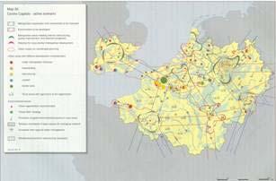
3 The transnational spatial visions National spatial visions and Leitbilder
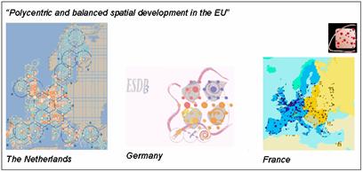
4 Planning traditions and visualising: The Netherlands Planning traditions and visualising: Germany
 Dutch Streekplannen ORA German LEPs/LEPros English RPGs/RSSs POLICIES AND INSTRUMENTS Vijfde Nota RO (PKB Part 3) Dutch Streekplannen ORA")
 multifunctional land")

 to strengthen the regional economic structure PARITY OF ACCESS TO INFRASTRUCTURE AND KNOWLEDGE Safeguard main infrastructure / European level and supra-regional")
 Modal shift / reduce traffic impacts Public transport Cycling and walking Traffic management and parking Information Communications")
 Integrated water management Integrated Coastal Zone Management River policies and prevention of flood risk Nature and landscape protection Ecological and biotope connections Forestry")

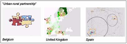
5 Planning traditions and visualising: UK Planning traditions and visualising POLICIES AND INSTRUMENTS Vijfde Nota RO (PKB Part 3) Dutch Streekplannen ORA German LEPs/LEPros English RPGs/RSSs POLICIES AND INSTRUMENTS Vijfde Nota RO (PKB Part 3) Dutch Streekplannen ORA German LEPs/LEPros English RPGs/RSSs POLICIES AND INSTRUMENTS Vijfde Nota RO (PKB Part 3) Dutch Streekplannen ORA German LEPs/LEPros English RPGs/RSSs POLYCENTRIC SPATIAL DEVELOPMENT AND A NEW URBAN-RURAL RELATIONSHIP Strengthen decentralised spatial and settlement structure Strengthen urban networks and crossborder connections Improve co-operation between cities and towns Urban areas / in Germany including: System of central places (centres of higher, medium and lower order) multifunctional land uses Promote mixed-use development and Containment of urbanisation and urban sprawl / promotion of brownfield development Preservation of open space within surrounding urban areas for leisure and recreation uses Safeguard Green Belts Improve liveability and performance of rural areas / promote rural diversification Strengthen agriculture Provision of housing Promote recreation and tourism / sports and recreation facilities Provision of employment land / strengthening of business clusters Provision of retail facilities / retail development Regeneration areas Conversion (military sites, industrial areas) to strengthen the regional economic structure PARITY OF ACCESS TO INFRASTRUCTURE AND KNOWLEDGE Safeguard main infrastructure / European level and supra-regional development axes Improve accessibility and transport infrastructure in and between urban networks Road infrastructure network Rail infrastructure network Airports Ports and waterways Freight transport Multi-modal transport corridors (including studies) Modal shift / reduce traffic impacts Public transport Cycling and walking Traffic management and parking Information Communications Technology (ICT) / Telecommunications Improve conditions for research and higher education / other social infrastructure WISE MANAGEMENT OF THE NATURAL AND CULTURAL HERITAGE OTHERS (including groundwater) Integrated water management Integrated Coastal Zone Management River policies and prevention of flood risk Nature and landscape protection Ecological and biotope connections Forestry and woodland Increase use of renewable energy / energy efficiency / location for wind turbines Waste management and treatment / sewage treatment Minerals and aggregates Air quality and emission protection Climate protection Redevelopment of contaminated land Protection of cultural heritage Define and strengthen sub-regions / sub-areas Defence and military sites Technical infrastructure (e.g. power stations, power lines)


6 What cartography for an integrated Europe? What is the appropriate agenda for spatial planning at European level? Level of abstraction? Function and role of maps at European level? Spatial analysis versus qualitative illustrations Intended audience Content and spatial reference Understanding of planning, approaches to mapping and the collection of spatial data Spatial positioning and education Thank you for your attention!
The National Policy Strategy for Infrastructure and Spatial Planning CODE24 CONFERENCE. Emiel Reiding
 The National Policy Strategy for Infrastructure and Spatial Planning Emiel Reiding Structure of presentation 1. Spatial planning in the Netherlands 2. National Policy Strategy Aims National interests 3.
The National Spatial Strategy
 Purpose of this Consultation Paper This paper seeks the views of a wide range of bodies, interests and members of the public on the issues which the National Spatial Strategy should address. These views
A new start for the Lisbon Strategy Working together for growth and jobs
 METREX Response Discussion Note METREX Nye Bevan House, 20 India Street, GLASGOW, G2 4PF T. +44 (0) 1292 317074 F. +44 (0) 1292 317074 secretariat@eurometrex.org http://www.eurometrex.org 1 PREFACE The
The ESPON Programme. Goals Main Results Future
 The ESPON Programme Goals Main Results Future Structure 1. Goals Objectives and expectations Participation, organisation and networking Themes addressed in the applied research undertaken in ESPON projects
The European territory: Strategic developmentd
 The European territory: Strategic developmentd Peter Mehlbye Workshop Strategic Development Catalonia 11 June 2002 THE LECTURE Structure I. Territorial trends II. Strategy for European spatial development
Spatial Planning and Territorial Development at the Regional Level
 Spatial Planning and Territorial Development at the Regional Level Vincent Nadin University of the West of England, UK Spatial Planning and Territorial Development at the Regional Level Vincent Nadin University
Land Use in the context of sustainable, smart and inclusive growth
 Land Use in the context of sustainable, smart and inclusive growth François Salgé Ministry of sustainable development France facilitator EUROGI vice president AFIGéO board member 1 Introduction e-content+
Assessment of Sustainable Land Use within the Town Planning Process Experiences with a Multi Criteria Approach (MCA)
") Assessment of Sustainable Land Use within the Town Planning Process Experiences with a Multi Criteria Approach (MCA) Dipl.-Geogr. Sophie Schetke Dipl.-Ing. Benedikt Frielinghaus, University of Bonn, Germany
Assessment of Sustainable Land Use within the Town Planning Process Experiences with a Multi Criteria Approach (MCA) Dipl.-Geogr. Sophie Schetke Dipl.-Ing. Benedikt Frielinghaus, University of Bonn, Germany
CLLD Cooperation OFFER
 Title of the proposed project (English) CLLD Cooperation OFFER PARKS PROTECTION III - Management, Protection and Economic Development in Protected Areas Type of project (select as many as you want) Cooperation
Integrated Infrastructure Planning & Spatial Mapping
 Integrated Infrastructure Planning & Spatial Mapping Presenter: Heidi Dixon, Principal Social Planner, DTPLI 23 May 2014 PART 1 PLAN MELBOURNE : Metropolitan Planning Strategy PART 2 Case Study: DTPLI
Land Use Modelling for Environmental and Ecological Policy Assessment:
 Judith Borsboom Land Use Modelling for Environmental and Ecological Policy Assessment: Sustainable Netherlands Study in collaboration with: Wageningen University & Research centre WL Delft Hydraulics Arcadis
Topic 4: Changing cities
 Topic 4: Changing cities Overview of urban patterns and processes 4.1 Urbanisation is a global process a. Contrasting trends in urbanisation over the last 50 years in different parts of the world (developed,
Mediterranean Sea and Territorial Development, Opportunities and Risks
 EESC Hearing Towards an EU Macro-Regional Strategy for the Mediterranean Mediterranean Sea and Territorial Development, Opportunities and Risks Michaela Gensheimer Structure of Intervention Part I: What
TABLE OF CONTENTS ARTICLE I. POLK COUNTY COMPREHENSIVE PLAN VOLUME 1. Page CHAPTER 1. GENERAL... A-1
 TABLE OF CONTENTS ARTICLE I. POLK COUNTY COMPREHENSIVE PLAN VOLUME 1 Page CHAPTER 1. GENERAL... A-1 DIVISION 1.100 GENERAL PROVISIONS... A-1 DIVISION 1.200 BASIC PRINCIPLES... A-6 DIVISION 1.300 THE PLANNING
Measuring Disaster Risk for Urban areas in Asia-Pacific
 Measuring Disaster Risk for Urban areas in Asia-Pacific Acknowledgement: Trevor Clifford, Intl Consultant 1 SDG 11 Make cities and human settlements inclusive, safe, resilient and sustainable 11.1: By
16540/14 EE/cm 1 DG E 1A
 Council of the European Union Brussels, 5 December 2014 (OR. en) 16540/14 ENV 965 CULT 139 NOTE From: To: Subject: General Secretariat of the Council Delegations Charter of Rome on Natural and Cultural
It is clearly necessary to introduce some of the difficulties of defining rural and
 UNIT 2 CHANGING HUMAN ENVIRONMENTS G2 Theme 2 Investigating Settlement Change in MEDCs 2.1 What are the distinctive features of settlements? It is clearly necessary to introduce some of the difficulties
CHAPTER 4 HIGH LEVEL SPATIAL DEVELOPMENT FRAMEWORK (SDF) Page 95
 Page 95") CHAPTER 4 HIGH LEVEL SPATIAL DEVELOPMENT FRAMEWORK (SDF) Page 95 CHAPTER 4 HIGH LEVEL SPATIAL DEVELOPMENT FRAMEWORK 4.1 INTRODUCTION This chapter provides a high level overview of George Municipality s
CHAPTER 4 HIGH LEVEL SPATIAL DEVELOPMENT FRAMEWORK (SDF) Page 95 CHAPTER 4 HIGH LEVEL SPATIAL DEVELOPMENT FRAMEWORK 4.1 INTRODUCTION This chapter provides a high level overview of George Municipality s
European spatial policy and regionalised approaches
 Findings of the ESPON 2006 Programme COMMIN Final Conference 26-27 April 2007 European spatial policy and regionalised approaches by Dr. Kai BöhmeB ! Territory matters Structure of presentation! Territorial
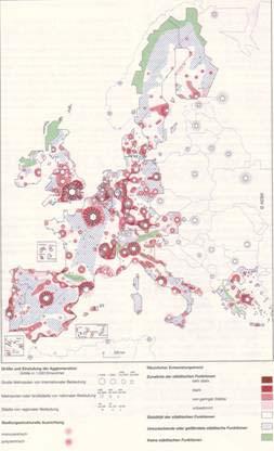
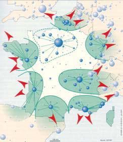
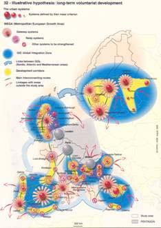
Towards a Polycentric Europe
 Towards a Polycentric Europe European Spatial Perceptions The Blue Banana Brunet, 1989 A Bunch of Grapes Kunzmann & Wegener, 1991 Economic Imbalances Core area of the EU: Pentagon of the metropolises of
Introduction to the Gozo & Comino Local Plan
 Introduction to the Gozo & Comino Local Plan What is a Local Plan? A Local Plan is a land use document with written text (policies and justifications) and maps; Reconciles local needs with strategic considerations;
COUNCIL OF THE EUROPEAN UNION. Brussels, 2 May /14 CULT 68
 COUNCIL OF THE EUROPEAN UNION Brussels, 2 May 2014 9129/14 CULT 68 NOTE from: General Secretariat of the Council to: Permanent Representatives Committee (Part 1) / Council No. prev. doc.: 8892/14 CULT
PURR: POTENTIAL OF RURAL REGIONS UK ESPON WORKSHOP Newcastle 23 rd November Neil Adams
 PURR: POTENTIAL OF RURAL REGIONS UK ESPON WORKSHOP Newcastle 23 rd November 2012 Neil Adams PURR: Potential of Rural Regions Introduction Context for the project A spectrum of knowledge Rural Potentials
How to measure Territorial Cohesion and Cooperation?
 How to measure territorial cohesion and cooperation? How to measure Territorial Cohesion and Cooperation? Brussels: 21 February Growth, Development or Cohesion? Economic Competitiveness Social Cohesion
COUNCIL OF EUROPE S SPATIAL DEVELOPMENT POLICY
 ESPON 2103 Programme Open Seminar Territorial Challenges and Cooperation in a Wider Europe Portorož, 2-3 June 2008 COUNCIL OF EUROPE S SPATIAL DEVELOPMENT POLICY Maria José Festas Senior Advisor, Directorate
State initiative following up the 2006 national planning report
 18 ness districts and public institutions, should be integrated with the opportunities for public transport services. State initiative following up the 2006 national planning report The Ministry of the
The CRP stresses a number of factors that point to both our changing demographics and our future opportunities with recommendations for:
 Plan Overview The CRP represents the first broad planning initiative covering Lake, Porter and LaPorte counties. Unlike previous plans released by NIRPC, which focused primarily on transportation, the
Use and demand of regions and cities
 Use and demand of regions and cities > Roger Read > Deputy Director of Physical Planning Strathclyde Regional Council 1976-1996 > Secretary General METREX 1996-present > METREX - founded in 1996 > 50+
Tackling urban sprawl: towards a compact model of cities? David Ludlow University of the West of England (UWE) 19 June 2014
 19 June 2014") Tackling urban sprawl: towards a compact model of cities? David Ludlow University of the West of England (UWE) 19 June 2014 Impacts on Natural & Protected Areas why sprawl matters? Sprawl creates environmental,
Tackling urban sprawl: towards a compact model of cities? David Ludlow University of the West of England (UWE) 19 June 2014 Impacts on Natural & Protected Areas why sprawl matters? Sprawl creates environmental,
CHAPTER 2. Strategic Context
 CHAPTER 2 Strategic Aim: To facilitate the future development of Cork as a national gateway city within the integrated land use and transportation framework set out in the Cork Area Strategic Plan 2001
Local Area Key Issues Paper No. 13: Southern Hinterland townships growth opportunities
 Draft Sunshine Coast Planning Scheme Review of Submissions Local Area Key Issues Paper No. 13: Southern Hinterland townships growth opportunities Key Issue: Growth opportunities for Southern Hinterland
Spatial information in strategic city planning - Zagreb experience. Darko Šiško City office for strategic planning, Zagreb
 Spatial information in strategic city planning - Zagreb experience Darko Šiško City office for strategic planning, Zagreb Overview Strategic city planning GI tools and trends Spatial data for strategic
This table connects the content provided by Education Perfect to the NSW Syllabus.
 Education Perfect Geography provides teachers with a wide range of quality, engaging and innovative content to drive positive student learning outcomes. Designed by teachers and written by our in-house
Edexcel Geography Advanced Paper 2
 Edexcel Geography Advanced Paper 2 SECTION B: SHAPING PLACES Assessment objectives AO1 Demonstrate knowledge and understanding of places, environments, concepts, processes, interactions and change, at
Urban-rural relations in Europe
 Urban-rural relations in Europe Typology of urban and rural characteristics developed by the ESPON 1.1.2 project Kaisa Schmidt-Thomé 14.12.2006 Sevilla JRC/IPTS Rural typologies -workshop ESPON 2006 Programme
THE ROLE OF REGIONAL SPATIAL PLANNING IN SUPPORTING LONG-TERM ECONOMIC GROWTH IN NORTHERN IRELAND
 THE ROLE OF REGIONAL SPATIAL PLANNING IN SUPPORTING LONG-TERM ECONOMIC GROWTH IN NORTHERN IRELAND Jenny Pyper Director 6 th Annual ICLRD Conference 20 January 2011 PURPOSE OF REGIONAL PLANNING Framework
Declaration Population and culture
 Declaration Population and culture The ministers of the parties to the Alpine Convention regard the socio-economic and socio-cultural aspects mentioned in Article 2, Paragraph 2, Item a., as being central
What European Territory do we want?
 Luxembourg, Ministére du Developpement Durable et des Infrastructures 23 April 2015 What European Territory do we want? Alessandro Balducci Politecnico di Milano Three points What the emerging literature
Lombardy Region Territorial Context and Planning Structures
 Lombardy Region Territorial Context and Planning Structures Carlo Palazzoli RUMORE project manager carlo_palazzoli@regione.lombardia.it 15th May 2018 / RUMORE Third Partner Meeting Lombardy Region in Europe
PROTOCOL ON THE IMPLEMENTATION OF THE ALPINE CONVENTION OF 1991 RELATING TO SPATIAL PLANNING AND SUSTAINABLE DEVELOPMENT
 PROTOCOL ON THE IMPLEMENTATION OF THE ALPINE CONVENTION OF 1991 RELATING TO SPATIAL PLANNING AND SUSTAINABLE DEVELOPMENT SPATIAL PLANNING AND SUSTAINABLE DEVELOPMENT" PROTOCOL Preamble The Republic of
GIS, Maps and Spatial Analyses in Urban Planning
 GIS, Maps and Spatial Analyses in Urban Planning LOOM.02.331 ANTO AASA PhD, researcher Power of visualization: What s this? Economic spaces in Europe (chorems based approach) Europe economy 1646 General:
Regional Growth Strategy Work Session Growth Management Policy Board
 Regional Growth Strategy Work Session Growth Management Policy Board September 6, 2018 1 Overview Recap June GMPB work session Objectives and outcomes Regional geographies Growth scenarios Breakout Discussion:
HSC Geography. Year 2013 Mark Pages 10 Published Jul 4, Urban Dynamics. By James (97.9 ATAR)
") HSC Geography Year 2013 Mark 92.00 Pages 10 Published Jul 4, 2017 Urban Dynamics By James (97.9 ATAR) Powered by TCPDF (www.tcpdf.org) Your notes author, James. James achieved an ATAR of 97.9 in 2013 while
HSC Geography Year 2013 Mark 92.00 Pages 10 Published Jul 4, 2017 Urban Dynamics By James (97.9 ATAR) Powered by TCPDF (www.tcpdf.org) Your notes author, James. James achieved an ATAR of 97.9 in 2013 while
PLANNING FOR SUSTAINABILITY IN SLOVENIAN TOWNS
 Int. Journal for Housing Science, Vol.31, No.3 pp 205-214, 2007 Published in the United States PLANNING FOR SUSTAINABILITY IN SLOVENIAN TOWNS Mojca Sasek Divjak Urban Planning Institute of the Republic
NATURE AND EXTENT OF PROPOSED DEVELOPMENT. Amount of Development Development Zones Distribution of Density Policies
 NATURE AND EXTENT OF PROPOSED DEVELOPMENT Amount of Development Development Zones Distribution of Density Policies DRAFT POOLBEG PLANNING SCHEME Amount of Development 78 4.1 The rationale for the overall
Legal problems of environmental management. Spatial planning and space management. M. Gajewski 2014 / 2015
 Legal problems of environmental management Spatial planning and space management M. Gajewski 2014 / 2015 Course contents (in brief) Constitutional basis of the environment protection system. General principles
The Governance of Land Use
 The planning system Levels of government and their responsibilities The Governance of Land Use Country fact sheet Germany Germany is a federal country with four levels of government. Below the national
Vincent Goodstadt. Head of European Affairs METREX European Network
 Vincent Goodstadt Head of European Affairs METREX European Network METREX (Network of 50 European Metropolitan Regions and Areas ) Exchanging Knowledge (e.g. Benchmarking) Climate Change CO2/80/50 Expertise
The Tyndall Cities Integrated Assessment Framework
 The Tyndall Cities Integrated Assessment Framework Alistair Ford 1, Stuart Barr 1, Richard Dawson 1, Jim Hall 2, Michael Batty 3 1 School of Civil Engineering & Geosciences and Centre for Earth Systems
Tourism. April State Planning Policy state interest guideline. Department of Infrastructure, Local Government and Planning
 Department of Infrastructure, Local Government and Planning State Planning Policy state interest guideline Tourism April 2016 Great state. Great opportunity. Preface Using this state interest guideline
DEPARTMENT OF GEOGRAPHY B.A. PROGRAMME COURSE DESCRIPTION
 DEPARTMENT OF GEOGRAPHY B.A. PROGRAMME COURSE DESCRIPTION (3 Cr. Hrs) (2340100) Geography of Jordan (University Requirement) This Course pursues the following objectives: - The study the physical geographical
The Governance of Land Use
 The planning system Levels of government and their responsibilities The Governance of Land Use COUNTRY FACT SHEET NORWAY Norway is a unitary state with three levels of government; the national level, 19
Unit 9: Changing urban environments
 Name: Unit 9: Changing urban environments I can statement... RAG Score. R=1, A=2, G=3 9.1 What are the characteristics of urbanisation. I can describe what urbanisation is. I can describe what a push and
Regional Plan 4: Integrating Ecosystem Services Mapping into Regional Land Use Planning
 Rural-Urban Outlooks: Unlocking Synergies (ROBUST) ROBUST receives funding from the European Union s Horizon 2020 research and innovation programme under grant agreement No 727988.* October 2018 Natural
Foreword. Vision and Strategy
 GREATER MANCHESTER SPATIAL FRAMEWORK Friends of Walkden Station Consultation Response January 2017 Foreword Friends of Walkden Station are a group of dedicated volunteers seeking to raise the status and
Poland, European Territory, ESPON Programme Warsaw, 2 July 2007 STRATEGY OF THE ESPON 2013 PROGRAMME
 Poland, European Territory, ESPON Programme 2007-2013 Warsaw, 2 July 2007 STRATEGY OF THE ESPON 2013 PROGRAMME Territory matters Regional diversity as asset Territorial potentials increasing in importance
Eduqas A GCSE Geography Course Options For 2018 assessment
 Eduqas A GCSE Geography Course Options For 2018 assessment has been an FSC Field Centre since 1957. It is ideally placed to provide access to the distinctive fluvial and post glacial landscapes of Shropshire
CORPORATION OF THE CITY OF COURTENAY COUNCIL MEETING AGENDA
 CORPORATION OF THE CITY OF COURTENAY COUNCIL MEETING AGENDA DATE: Monday, January 14, 2013 PLACE: City Hall Council Chambers TIME: 4:00 p.m. 1.00 ADOPTION OF MINUTES 1. Adopt January 7, 2013 Regular Council
Strengthening the cooperation in the region: Carpathian, Tisa,, Danube and Black Sea areas
 Strengthening the cooperation in the region: Carpathian, Tisa,, Danube and Black Sea areas 14th October 2009 SEE Annual Conference Advancing development through transnational cooperation in South East
CERTIFIED RESOLUTION. introduction: and dated May 29, 2017, as attached, as appropriate
 15322 Buena Vista Avenue, White Rock BC, Canada V4B 1Y6 www.whiterockcity.ca City of White Rock P: 604.541.22121 F: 604.541.9348 /2tC% City Clerk s Office IT E ROC K June 13,2017 Stephanie Lam, Deputy
Urban-Rural Partnerships in Europe
 Disclaimer: The views expressed in this document are those of the author, and do not necessarily reflect the views and policies of the Asian Development Bank (ADB), its Board of Directors, or the governments
The Contested Cultural Landscape of a Lebanese Border Town: MARJA AYOUN
 The Contested Cultural Landscape of a Lebanese Border Town: MARJA AYOUN IBD 2013 FNAS MAY 2013 Dr. Christine Mady, City & Regional Planning NDU -FAAD In this Presentation A PLANNING PERSPECTIVE INTRODUCING
TOWARDS STRATEGIC SPATIAL PLANNING IN JAMAICA: THE NATIONAL SPATIAL PLAN
 TOWARDS STRATEGIC SPATIAL PLANNING IN JAMAICA: THE NATIONAL SPATIAL PLAN JIEP 5th Biennial Conference on the Environment: Balancing National Development and Environmental Protection June 6, 2011 Jamaica
Botswana National Spatial Plan Botsreal Property Forum- 30 May, 2018
 Botswana National Spatial Plan 2036 Botsreal Property Forum- 30 May, 2018 What is the National Spatial Plan? A framework and process for planning that is: National (to guide national development policies,
Urbanization and Sustainable Development of Cities: A Ready Engine to Promote Economic Growth and Cooperation
 Urbanization and Sustainable Development of Cities: A Ready Engine to Promote Economic Growth and Cooperation Wan Portia Hamzah Institute of Strategic and International Studies (ISIS) Malaysia 10 September
Long Term Plan What is planned for Murchison?
 Long Term Plan 2018-2028 What is planned for Murchison? 1.0 Introduction The following information provides an overview of significant projects Council has planned for the Murchison settlement in the Long
Developing the Badagry Masterplan
 Developing the Badagry Masterplan Yann Leclercq 1.0 Introduction The Badagry sub-region forms a major part of Lagos State in Nigeria, which is estimated to be growing in population at a rate of 3.5% per
Transport Planning in Large Scale Housing Developments. David Knight
 Transport Planning in Large Scale Housing Developments David Knight Large Scale Housing Developments No longer creating great urban spaces in the UK (Hall 2014) Transport Planning Transport planning processes
Regional collaboration & sharing: pathway to sustainable, just & inclusive cities in Europe
 Berlin s Environmental Justice Map Regional collaboration & sharing: pathway to sustainable, just & inclusive cities in Europe Dr. Andrea I Frank Cardiff University School of Geography & Planning A. Sustainability:
Entrepreneurship on islands and other peripheral regions. Specific Contract No 6511 implementing Framework contract No CDR/DE/16/2015/
 Entrepreneurship on islands and other peripheral regions Specific Contract No 6511 implementing Framework contract No CDR/DE/16/2015/ Aims of this study: To analyse the particular challenges and obstacles
Outline. Tourism A Viable Option for Abandoned Mines?
 Tourism A Viable Option for Abandoned Mines? Pete Whitbread-Abrutat Post-Mining Alliance, Eden Project Outline Post-Mining Alliance Mining and tourism Aspects of mining and tourism Case studies Success
Date: June 19, 2013 Meeting Date: July 5, Consideration of the City of Vancouver s Regional Context Statement
 Section E 1.5 To: From: Regional Planning and Agriculture Committee Lee-Ann Garnett, Senior Regional Planner Planning, Policy and Environment Department Date: June 19, 2013 Meeting Date: July 5, 2013 Subject:
Geodiversity, Geoheritage & Geoconservation
 Geodiversity, Geoheritage & Geoconservation Geodiversity what is its place within nature diversity? Geodiversity is the variety of nature elements, such as minerals, rocks, fossils, landforms and their
Dar es Salaam - Reality Check Workshop
 Dar es Salaam - Reality Check Workshop hosted by GIZ and Dar es Salaam City Council Introduction: Key Urban Characteristics of Dar es Salaam Challenges and Opportunities for Resilient Development in the
Joint Planning Advisory Council July 19, 2011
 Joint Planning Advisory Council July 19, 2011 Global Cities Program Objectives Helping advance strategic thinking in a variety of critical areas. Facilitating informed decisionmaking on the part of public
PROMOTING NATURE CONSERVATION AND SUSTAINABLE AGRICULTURAL DEVELOPMENT IN THE RURAL AREAS OF HONG KONG
 1 PROMOTING NATURE CONSERVATION AND SUSTAINABLE AGRICULTURAL DEVELOPMENT IN THE RURAL AREAS OF HONG KONG Director of Agriculture, Fisheries and Conservation Dr. LEUNG Siu-fai A STONE S THROW AWAY FROM
Economic Benefit Study on Value of Spatial Information Australian Experience
 Economic Benefit Study on Value of Spatial Information Australian Experience Dr Zaffar Sadiq Mohamed-Ghouse Director, International Relations Cooperative Research Centre for Spatial Information zsadiq@crcsi.com.au
New GCSE Geography AQA
 Learning Checklist Half Term 1 26 th September 3 rd October 10 th October 17 th October 1.1.1 Tectonic Hazards Plate tectonics theory. Global distribution of earthquakes and volcanic eruptions and their
Project for Formulation of Comprehensive Development Master Plan in the Mombasa Gate City in Republic of Kenya
 Project for Formulation of Comprehensive Development Master Plan in the Mombasa Gate City in Republic of Kenya WG: Land Use (Development Vision, Structure Plan) January 18, 2016 JICA Expert Team Working
Levels of spatial planning, Preparatory Land Use Plan, Sustainable Development. The Stuttgart Example
 Levels of spatial planning, Preparatory Land Use Plan, Sustainable Development. The Stuttgart Example Dipl.-Ing. Robert Schulze Dieckhoff Urban Planner Department of City Planning and Urban Renewal State
Navigable maritime and river waterways in the seaside - Danube Delta area and the connected rural development
 SUMMARY OF Ph-D Thesis, with title RESEARCH STUDIES ON MANAGEMENT IMPROVEMENT OF MARITIME AND RIVER TRANSPORT ACTIVITY IN THE COASTAL AND DANUBE DELTA AREA FROM AN ENVIROMENTAL, ECONOMIC AND SOCIAL PERSPECTIVE
1. Demand for property on the coast
 1. Demand for property on the coast Key message Irrespective of density and location, population in Europe in general tends to concentrate in coastal areas. Detailed spatial elaboration of processes shows
A DECLARATION by the spatial planning aldermen of Amsterdam, Rotterdam, The Hague and Utrecht regarding future urban development in the Netherlands.
 DELTAMETROPOLIS A declaration by the spatial planning aldermen of Amsterdam, Rotterdam, The Hague and Utrecht regarding future urban development in The Netherlands. DELTA METROPOLIS A DECLARATION by the
Third Cohesion report February 2004
 February 2004 A new partnership for cohesion Convergence, Competitiveness and Co-operation METREX meeting S. Sebastian, Luisa Sanches DG REGIO The 3rd CR structure 1. Analysis of situation and trends in
Bishkek City Development Agency. Urban Planning Bishkek
 Bishkek City Development Agency Urban Planning Bishkek Bishkek City Development Agency Official name City budget Population Area GRP Import value Export value External trade turnover Foreign direct investments
Summary Draft National Policy Strategy for Infrastructure and Spatial Planning with the Strategic Environmental Impact Assessment
 Summary Draft National Policy Strategy for Infrastructure and Spatial Planning with the Strategic Environmental Impact Assessment Summary Draft National Policy Strategy for Infrastructure and Spatial
Urban Planning Word Search Level 1
 Urban Planning Word Search Level 1 B C P U E C O S Y S T E M P A R E U O E U R B A N P L A N N E R T N S T D H E C O U N T Y G E R E R D W R E N I C I T Y C O U N C I L A A A S U G G C I L A G P R I R
accessibility accessibility by-pass bid-rent curve bridging point administrative centre How easy or difficult a place is to reach.
 accessibility accessibility How easy or difficult a place is to reach. How easy or difficult it is to enter a building. administrative centre bid-rent curve The function of a town which is a centre for
Central Baltic Programme
 Central Baltic Programme 2014-2020 About the Central Baltic Programme 2014-2020 Builds on the Central Baltic INTERREG IV A Programme 2007-2013 Cross-border cooperation projects in the central Baltic Sea
Summary and Implications for Policy
 Summary and Implications for Policy 1 Introduction This is the report on a background study for the National Spatial Strategy (NSS) regarding the Irish Rural Structure. The main objective of the study
GCE. Geography. Mark Scheme for January Advanced Subsidiary GCE Unit F762: Managing Change in Human Environments
 GCE Geography Advanced Subsidiary GCE Unit F762: Managing Change in Human Environments Mark Scheme for January 2012 Oxford Cambridge and RSA Examinations OCR (Oxford Cambridge and RSA) is a leading UK
Compact guides GISCO. Geographic information system of the Commission
 Compact guides GISCO Geographic information system of the Commission What is GISCO? GISCO, the Geographic Information System of the COmmission, is a permanent service of Eurostat that fulfils the requirements
The international patterns of spatial planning system and choice of China. Cai yumei China land use planning and surveying institute (China, beijing)
") FIG Working Week, Rome, Italy 6 10 May 2012 The international patterns of spatial system and choice of China Cai yumei China land use and surveying institute (China, beijing) Outline Background Problem
FIG Working Week, Rome, Italy 6 10 May 2012 The international patterns of spatial system and choice of China Cai yumei China land use and surveying institute (China, beijing) Outline Background Problem
New Prospects for Peripheral Rural Regions Helmut Hiess Glasgow, 19th of May 2010
 New Prospects for Peripheral Rural Regions Helmut Hiess Glasgow, 19th of May 2010 ÖROK: Organisation & Tasks Austrian Conference on Spatial Planning (ÖROK, since 1971): Joint organisation by Federal level,
[ ] MONITORING THE SPATIAL IMPACTS OF THE EGNATIA MOTORWAY egnatia odos observatory
![[ ] MONITORING THE SPATIAL IMPACTS OF THE EGNATIA MOTORWAY egnatia odos observatory](/thumbs/72/66290986.jpg "[ ] MONITORING THE SPATIAL IMPACTS OF THE EGNATIA MOTORWAY egnatia odos observatory") ] egnatia odos observatory MONITORING THE SPATIAL IMPACTS OF THE EGNATIA MOTORWAY 2014 http://observatory.egnatia.gr MINISTRY OF INFRASTRUCTURE, TRANSPORT AND NETWORKS 2 A tool at the service of spatial
] egnatia odos observatory MONITORING THE SPATIAL IMPACTS OF THE EGNATIA MOTORWAY 2014 http://observatory.egnatia.gr MINISTRY OF INFRASTRUCTURE, TRANSPORT AND NETWORKS 2 A tool at the service of spatial
Belfairs Academy GEOGRAPHY Fundamentals Map
 YEAR 12 Fundamentals Unit 1 Contemporary Urban Places Urbanisation Urbanisation and its importance in human affairs. Global patterns of urbanisation since 1945. Urbanisation, suburbanisation, counter-urbanisation,
TERRITORIAL IMPACT ASSESSMENT: AN APPROACH TO IMPROVE THE VERTICAL AND HORIZONTAL INTEGRATION OF EU POLICIES
 TERRITORIAL IMPACT ASSESSMENT: AN APPROACH TO IMPROVE THE VERTICAL AND HORIZONTAL INTEGRATION OF EU POLICIES Naja Marot & Mojca Golobič Biotehnical Faculty, University of Ljubljana, Slovenia RSA Workshop
CLAREMONT MASTER PLAN 2017: LAND USE COMMUNITY INPUT
 Planning and Development Department 14 North Street Claremont, New Hampshire 03743 Ph: (603) 542-7008 Fax: (603) 542-7033 Email: cityplanner@claremontnh.com www.claremontnh.com CLAREMONT MASTER PLAN 2017:
Sustainable and Harmonised Development for Smart Cities The Role of Geospatial Reference Data. Peter Creuzer
 Sustainable and Harmonised Development for Smart Cities The Role of Geospatial Reference Data Peter Creuzer 1. Introduction - Smart Cities and Geodata 2. Geodata in Germany 3. Examples 4. Data and Service
Proposed Scope of Work Village of Farmingdale Downtown Farmingdale BOA Step 2 BOA Nomination Study / Draft Generic Environmental Impact Statement
 Proposed Scope of Work Village of Farmingdale Downtown Farmingdale BOA Step 2 BOA Nomination Study / Draft Generic Environmental Impact Statement The scope of work that follows incorporates and covers