Compiled by the Queensland Studies Authority
|
|
|
- Joel Bridges
- 5 years ago
- Views:
Transcription
1 Geography Annotated sample assessment Practical exercise Compiled by the February 2007 About this task This sample demonstrates several features: A practical exercise should be conducted under examination conditions for the purpose of the senior Geography syllabus. It gathers evidence of what the students know and can do in terms of analytical processes, decision-making processes and their ability to communicate through the manipulation of geographical data and the use of geographical skills. It involves students manipulating a range of data in order to observe, record, interpret, analyse, synthesise and make informed judgements about a variety of geographic information. The exercise should not lead to short-answer or single-word responses. It must give students the opportunity to demonstrate their analytical skills. Questions should lead to an extended paragraph response of words. The exercise should provide students with the opportunity to show evidence of their decision-making skills. This involves examining a range of alternatives and applying appropriate criteria in order to make a recommendation. This annotated sample is intended to be a guide to help teachers plan and develop assessment tasks for individual school settings.
2 Purposes of assessment The purposes of assessment are to provide feedback to students and parents about the learning that has occurred and to provide feedback to teachers about the teaching and learning processes. Assessment also provides information on which to base judgments about how well students meet the general objectives of the course. In designing an assessment program, it is important that the assessment tasks, conditions and criteria be compatible with the general objectives and the learning experiences. Assessment then becomes an integral aspect of a course of study. More information on school-based assessment is available from the QSA website. Developing assessment tasks An assessment task is work undertaken by a student in response to an assessment instrument and learning experiences and is outlined in a task sheet. In describing assessment tasks to students, teachers need to ensure that: the techniques and instruments chosen allow students to demonstrate achievement in the particular objective or objectives the tasks are written in clear, unambiguous language, thereby ensuring that the teacher and the student have the same understanding the criteria for both formative and summative assessment always refer to the individual s achievement, even if assessment has involved group work in the assessment of students, the guidelines for quality and equity apply; these are available from the QSA website task conditions, which are to be consistent with the conditions described in the syllabus, are stated on task sheets.
3 Year 12 Geography Semester 3, 2007 Practical exercise Theme 3: Social Environments Clear, unambiguous conditions. Practical exercises are always assessed under supervised conditions. Student: Teacher: Conditions Supervised test no notes allowed Part A: Data manipulation, 60 minutes Part B: Analytical Processes, 60 minutes Decision-making processes Criteria assessed Criterion 2: Analytical processes Criterion 3: Decision-making processes Criterion 4: [Research &] communication (see over) Practical exercises are divided into two parts. Part A is about data manipulation. It is from this data manipulation that evidence of the Communication criterion is drawn. Part B is where evidence of student performance of analytical processes and decision-making processes is gathered. It is appropriate to give students additional data. The analysis and decision making should be based on the outcomes of Part A but may need additional datasets.
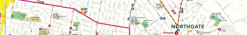
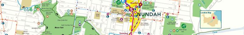
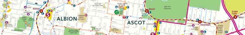
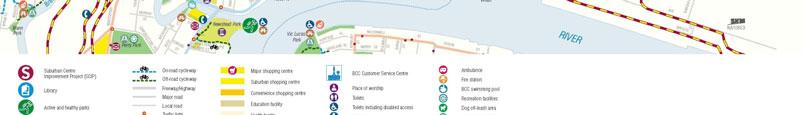
4 Part A: Data manipulation [Criterion 4: Communication] 1. On the maps provided complete two choropleth maps using the data provided about: a. Couple family with children b. Couple family no children The choropleth maps and the [from Table 1: Family type inner north east suburbs] compound bar graphs provide students with the opportunity to identify and explain simple and Ensure that you complete your maps appropriately. complex relationships. 2. Complete a compound bar graph [on the graph paper provided] for the information provided for Household types from Table 2: Household type inner north-east suburbs. Ensure that you complete your graphs appropriately. 3. From the map of the local area construct of précis map of public transport and open space recreation areas. Students will be given accurate précis and choropleth maps in order to ensure equity for analytical processes and decisionmaking processes. The range of elements in the Communication criterion requires students to clearly and concisely use accurate geographic conventions and proficiently integrate maps, diagrams, statics adhering to geographic conventions. The learning experiences that support this assessment task would include explicit reinforcing of geographic conventions. A choropleth map and a compound bar graph provide sufficient complexity in analysis that is appropriate to the senior phase of learning.
5 Part B: Written responses, Criterion 2: Analytical [processes] This question clearly invites the student to demonstrate both identification and explanation of geographic patterns and processes. Students would, through their understanding of choropleth maps, be able to show what they know about the relationships between the demographic distributions and what these patterns mean. 1. In a paragraph of about 100 words describe the distribution patterns evident in the completed choropleth maps. 2. In a paragraph of about 100 words explain the relationships between the distribution of household types and family types in these suburban areas. Make use of the provided maps in considering the relationship between the choropleth maps and the graph. Are there any anomalies evident in the data? If so, what are they? 3. In a paragraph of about 200 words describe the patterns of public transport and open space recreation and what this means for Nundah, Clayfield and Albion. Decision is at a local scale and is manageable for students. It is clearly based on the data that [Criterion 3: Decision-making processes] they have manipulated. 1. The Brisbane City Council, as part of the new regional plan for South East Queensland, is proposing a medium-to-high-density development for the north-eastern suburbs. They are considering three sites [see Fig 1]: a) Nundah [Site A] b) Clayfield [Site B] c) Albion. [Site C] The purchase cost of the units there will be a mix of 1 and 2 bedroom units one bedroom will start at $250000, 2 bedrooms will start at $ The rents charged for those units being rented will start at $250 per week for the one bedroom and $300 per week for the two bedroom. You have been asked to advise the council on the more appropriate location for such a development. In determining your response you will consider the three locations in terms of the following criteria: a) The location will promote further the use of public transport for the residents of the development. b) The location will be located in good proximity to open space for recreation activities. c) The rental costs for units in the development will be appropriate for the economic indicators for the area. You can use any of the other information provided in framing your response. Your response to the council will be about 250 words in length and, in advising them of your decision, you will justify your decision with reasoned and logical arguments. Resources Map of Albion Source Brisbane City Council website Students are given the appropriate criteria to apply to the alternative strategies. The strategies are all valid options. There is no one, right answer.


6
7 Table 1: Family type inner north-eastern suburbs [source: Brisbane City Council (2005): A Statistical Portrait of Brisbane] Family type (percentages) Families(a) in occupied private dwellings (excl overseas visitors) Couple family One Parent Other Total with children no children family family Albion Ascot Clayfield Hamilton Hendra Lutwyche Nundah Wooloowin Inner North-East Region Brisbane City (a) includes same-sex couple families Table 2: Household type inner north-eastern suburbs [source: Brisbane City Council (2005): A Statistical Portrait of Brisbane] Household type (percentages) Occupied private dwellings (a) Family households Non-family households Lone person households Group households Total households Albion Ascot Clayfield Hamilton Hendra Lutwyche Nundah Wooloowin Inner North-East Region Brisbane City (a) Excludes 'Non-Classifiable households' and 'Visitor Only households'
8 Table 3: Weekly individual income inner north-eastern suburbs [source: Brisbane City Council (2005): A Statistical Portrait of Brisbane] Weekly individual income (percentages) Persons aged 15 years and over (excl overseas visitors) Negative/ nil income $1 - $199 $200-$399 $400-$599 $600-$999 $1,000 or more Not stated Albion Ascot Clayfield Hamilton Hendra Lutwyche Nundah Wooloowin Inner North-East Region Brisbane City Total Table 4: Average number of people per dwelling inner north-eastern suburbs [source: Brisbane City Council (2005): A Statistical Portrait of Brisbane] Average number of people per dwelling Occupied private dwellings Separate House Townhouse Unit Caravan, cabin, houseboat Other(a) Not Stated Albion Ascot Clayfield Hamilton Hendra Lutwyche Nundah Wooloowin Inner North-East Region Brisbane City Total
9 Table 5: Dwelling stock inner north-eastern suburbs [source: Brisbane City Council (2005): A Statistical Portrait of Brisbane] Dwelling stock (percentages) All private dwellings Separate House Townhouse Unit Caravan, cabin, houseboat Other(a) Not Stated Unoccupied Dwelling Albion Ascot Clayfield Hamilton Hendra Lutwyche Nundah Wooloowin Inner North-East Region Brisbane City (a) includes improvised home, tent, sleepers out, house/flat attached to shop, office etc Total Table 6: Method of travel to work - inner north eastern suburbs [source: Brisbane City Council (2005): A Statistical Portrait of Brisbane] Method of travel to work (percentages) Employed persons (excluding overseas visitors) Train only Bus only Car as driver or passenger Motorbike/ motor scooter Bicycle Walked only Other(a) Worked at Albion Ascot Clayfield Hamilton Hendra Lutwyche Nundah Wooloowin Inner North-East Region Brisbane City (a) includes ferry, tram, taxi, any two methods, any three methods, other home
10 The criteria need to be adapted to what actual elements of the full range of the criterion are to be captured in the student responses. They should be clear, explicit statements about what should be identifiable in the student work. Table 14: Standards associated with exit criteria (This table spreads over two pages.) Criterion Standard A Standard B Standard C Standard D Standard E 2. Analytical processes in-depth identification and explanation of geographical patterns and processes insightful transformation, interpretation and extrapolation of geographical information accurate identification and thorough explanation of simple and complex relationships, including anomalies detailed identification and explanation of geographical patterns and processes effective transformation, interpretation and extrapolation of geographical information mostly accurate identification and significant explanation of simple and complex relationships identification and explanation of some geographical patterns and processes some transformation, interpretation and extrapolation of geographical information identification and explanation of simple relationships identification of simple geographical patterns and processes superficial transformation, interpretation and extrapolation of geographical information identification of some simple relationships identification of some simple geographical patterns unsubstantiated geographical information relationships are inadequately identified or established
11 Criterion Standard A Standard B Standard C Standard D Standard E 3. Decisionmaking processes 4. Research & communication comprehensive and thorough evaluation of alternative proposals, strategies, solutions and plans insightful and balanced application of a range of appropriate criteria to the decision well reasoned and logical arguments to justify decisions clear, concise accurate and geographic conventions for choropleth maps and compound bar graphs adhering to geographic conventions for choropleth maps and compound bar graphs detailed evaluation of alternative proposals, strategies, solutions and plans effective and balanced application of appropriate criteria to the decision supported arguments to justify decisions using appropriate geographic conventions for choropleth maps and compound bar graphs mostly adhering to geographic conventions for choropleth maps and compound bar graphs evaluation of alternative proposals, strategies, solutions and plans application of some criteria to the decision justification of decisions using basic geographic conventions for choropleth maps and compound bar graphs with some adherence to geographic conventions for choropleth maps and compound bar graphs some evaluation of alternative proposals, strategies, solutions and plans some connections to factors affecting the decisions decisions are stated without justification using restricted geographic conventions for choropleth maps and compound bar graphs referencing of geographic conventions is inappropriate for choropleth maps and compound bar graphs some unconnected conclusions about the geographical problems no decisions evident obscure little or no use of geographic conventions for choropleth maps and compound bar graphs
Sample extended field-based investigation assessment task
 Earth Science Sample assessment Sample extended field-based investigation assessment task Compiled by the Redlands College 2007 About this task This sample is intended to be a guide to help teachers plan
Sample assessment task. Task details. Content description. Year level 7
 Sample assessment task Year level 7 Learning area Subject Title of task Task details Description of task Type of assessment Purpose of assessment Assessment strategy Evidence to be collected Suggested
Marking Scheme Field Work. 6 International Geography Olympiad. Brisbane
 Marking Scheme Field Work th 6 International Geography Olympiad Brisbane June 2006 Question - Map - 7 Marks Mark out of 4 and divide by 2 at the end. (Sample map was provided to markers.) Shading according
External Assessment subject report
 External Assessment subject report 160690 The State of Queensland (Queensland Curriculum and Assessment Authority) 2016 Queensland Curriculum and Assessment Authority PO Box 307 Spring Hill QLD 4004 Australia
2002 HSC Notes from the Marking Centre Geography
 2002 HSC Notes from the Marking Centre Geography 2003 Copyright Board of Studies NSW for and on behalf of the Crown in right of the State of New South Wales. This document contains Material prepared by
Year 8 standard elaborations Australian Curriculum: Geography
 Purpose Structure The standard elaborations (SEs) provide additional clarity when using the Australian Curriculum achievement standard to make judgments on a five-point scale. These can be used as a tool
GFS Geography Medium Term Plan Year 8 AUTUMN
 Context: Unit of work that focusing on the continent of Africa. Students will identify the range of variations in climate, culture, population, changing economies and levels of development. This unit will
Assessment Task: Coastal environments
 Assessment Task: Coastal environments Karen Bowden, GTANSW Councillor Around the world changes to coastlines occur due to natural and human environmental forces. Examples of these changes may include erosion
Urban Geography. Unit 7 - Settlement and Urbanization
 Urban Geography Unit 7 - Settlement and Urbanization Unit 7 is a logical extension of the population theme. In their analysis of the distribution of people on the earth s surface, students became aware
Biology Sample work program. March 2013
 Biology 2004 Sample work program March 2013 Biology 2004 Sample work program Compiled by the Queensland Studies Authority March 2013 A work program is the school s plan of how the course will be delivered
A Note on Methods. ARC Project DP The Demand for Higher Density Housing in Sydney and Melbourne Working Paper 3. City Futures Research Centre
 A Note on Methods ARC Project DP0773388 The Demand for Higher Density Housing in Sydney and Melbourne Working Paper 3 City Futures Research Centre February 2009 A NOTE ON METHODS Dr Raymond Bunker, Mr
Year 9 plan Victorian Curriculum: Humanities Semester Two (Geography/Economics and Business)
") Year 9 plan Victorian Curriculum: Humanities Semester Two (Geography/Economics and Business) Implementation year: School name: Kyabram P-12 College Prepared By: Rowena Morris Identify Curriculum Curriculum
Year 9 plan Victorian Curriculum: Humanities Semester Two (Geography/Economics and Business) Implementation year: School name: Kyabram P-12 College Prepared By: Rowena Morris Identify Curriculum Curriculum
Data Collection. Lecture Notes in Transportation Systems Engineering. Prof. Tom V. Mathew. 1 Overview 1
 Data Collection Lecture Notes in Transportation Systems Engineering Prof. Tom V. Mathew Contents 1 Overview 1 2 Survey design 2 2.1 Information needed................................. 2 2.2 Study area.....................................
Subject: Geography Scheme of Work: B1 to B6 Mastery tiles. Term: Autumn/Spring/Summer
 Subject: Geography Scheme of Work: B1 to B6 Mastery tiles Term: Autumn/Spring/Summer Topic / Unit(s) Overview / Context Introduction to geography. An introduction to geography including basic map skills
RESIDENTIAL SATISFACTION IN THE CHANGING URBAN FORM IN ADELAIDE: A COMPARATIVE ANALYSIS OF MAWSON LAKES AND CRAIGBURN FARM, SOUTH AUSTRALIA
 RESIDENTIAL SATISFACTION IN THE CHANGING URBAN FORM IN ADELAIDE: A COMPARATIVE ANALYSIS OF MAWSON LAKES AND CRAIGBURN FARM, SOUTH AUSTRALIA by Michael Chadbourne BEPM (Hons) University of Adelaide Thesis
Using Geography to Plan Civil War Campsites
 Jake Gordon Civil War Campsite Mapping Lesson Plan pg1 Using Geography to Plan Civil War Campsites Overview: This lesson is designed for an 8 th grade social studies class during the Civil War unit. Students
Too Close for Comfort
 Too Close for Comfort Overview South Carolina consists of urban, suburban, and rural communities. Students will utilize maps to label and describe the different land use classifications. Connection to
Factors that Shape Places Stage 3 Geography
 Factors that Shape Places Stage 3 Geography Summary This unit is written for Stage 3 "Factors that shape places". It is a Geographical Inquiry, enabling students to work through the 3 stages of inquiry;
Historical Fisheries off the Grand Banks (Wet and Dry Fisheries)
") Lesson Overview Historical Fisheries off the Grand Banks (Wet and Dry Fisheries) The French conducted the earliest trans-atlantic fishery with the Portuguese fishermen, soon joined by Basques, who took
Lesson Overview Historical Fisheries off the Grand Banks (Wet and Dry Fisheries) The French conducted the earliest trans-atlantic fishery with the Portuguese fishermen, soon joined by Basques, who took
Your web browser (Safari 7) is out of date. For more security, comfort and. the best experience on this site: Update your browser Ignore
 is out of date. For more security, comfort and. the best experience on this site: Update your browser Ignore") Your web browser (Safari 7) is out of date. For more security, comfort and Activityengage the best experience on this site: Update your browser Ignore Comparing Historical Maps How can historical maps
Your web browser (Safari 7) is out of date. For more security, comfort and Activityengage the best experience on this site: Update your browser Ignore Comparing Historical Maps How can historical maps
COMMUNITY SERVICE AREA
 INSTITUTE FOR TRIBAL ENVIRONMENTAL PROFESSIONALS Tribal Waste and Response Assistance Program (TWRAP) Developing and Implementing a Tribal Integrated Solid Waste Management Plan April 12-14, 2016 Palm
Typical information required from the data collection can be grouped into four categories, enumerated as below.
 Chapter 6 Data Collection 6.1 Overview The four-stage modeling, an important tool for forecasting future demand and performance of a transportation system, was developed for evaluating large-scale infrastructure
2005 HSC Notes from the Marking Centre Geography
 2005 HSC Notes from the Marking Centre Geography 2006 Copyright Board of Studies NSW for and on behalf of the Crown in right of the State of New South Wales. This document contains Material prepared by
SPACE-TIME ACCESSIBILITY MEASURES FOR EVALUATING MOBILITY-RELATED SOCIAL EXCLUSION OF THE ELDERLY
 SPACE-TIME ACCESSIBILITY MEASURES FOR EVALUATING MOBILITY-RELATED SOCIAL EXCLUSION OF THE ELDERLY Izumiyama, Hiroshi Institute of Environmental Studies, The University of Tokyo, Tokyo, Japan Email: izumiyama@ut.t.u-tokyo.ac.jp
MTH-2101 Algebraic Modeling
 MTH-2101 Algebraic Modeling Formative evaluation The trip Student name Record number Teacher name Birthday Center Date Schoolboard Mark July 2015 INSTRUCTIONS Page 2 of 14 Time 2 h 30 Answers If needed,
GCE. Geography. Student Guidance. Revised GCE. AS Unit 3: Fieldwork Skills and Techniques in Geography: the summary statement and table of data
 GCE Revised GCE Geography Student Guidance AS Unit 3: Fieldwork Skills and Techniques in Geography: the summary statement and table of data For first teaching from September 2016 For first award of AS
LEVEL 3 GEOGRAPHY COURSE BOOKLET
 LEVEL 3 GEOGRAPHY COURSE BOOKLET Name: Welcome to Level 3 Geography! The Aims of School Geography Geography aims, through its integrative approach, to foster a balanced view of and respect for the environment
Touring Around the Islands of Atlantic Canada
 Lesson Overview Touring Around the Islands of Atlantic Canada In this lesson, students will examine the history and heritage of the islands of Atlantic Canada and examine their similarities and differences.
Work Program. Senior Chemistry Syllabus. Section Topic Page
 Contents Work Program Senior Chemistry 2007 Syllabus Section Topic Page A view of Science and Science Education. Refer to page 1 of Chemistry Syllabus 2007 published by the Queensland Studies Authority
Mapping Project. Name: Theme:
 Mapping Project Name: Theme: Your Task: You will use the information from several thematic maps to create a map of your own using Google Maps. Your map will have a clear theme, and will attempt to answer
NSW Education Standards Authority. Geography Geography Life Skills Stage 6 Draft Directions for Syllabus Development
 NSW Education Standards Authority Geography Geography Life Skills Stage 6 Draft Directions for Syllabus Development for Consultation 23 July 2018 2 September 2018 2018 NSW Education Standards Authority
Course Outline. School Name: Keewaytinook Internet High School. Department Name: Canadian and World Studies. Ministry of Education Course Title:
 School Name: Keewaytinook Internet High School Department Name: Canadian and World Studies Course Outline Ministry of Education Course Title: Travel and Tourism: A Geographic Perspective Grade Level: 11
Institute for Global Environmental Strategies: Discover Earth Program Materials
 Lesson Summary Students will use either a computer interface or a thermometer and graph paper to learn about the different absorption properties of different albedos. Prior Knowledge & Skills Graphing
The planning and programming of Mathematics is designed to give students opportunities to:
 NUMERACY AGREEMENT PURPOSE The Lucindale Area School Numeracy Agreement outlines the agreed approaches to teaching Mathematics and Numeracy across the school. It will outline school specific approaches
Physics 2019 v1.2. IA2 high-level annotated sample response. Student experiment (20%) August Assessment objectives
 August Assessment objectives") Student experiment (0%) This sample has been compiled by the QCAA to assist and support teachers to match evidence in student responses to the characteristics described in the instrument-specific marking
Student experiment (0%) This sample has been compiled by the QCAA to assist and support teachers to match evidence in student responses to the characteristics described in the instrument-specific marking
Using OS Resources - A fieldwork activity for Key Stage 2
 Using OS Resources - A fieldwork activity for Key Stage 2 Liz Spincer, Saltford CE Primary School Outline of the fieldwork project: This series of activities was designed to illustrate how Primary School
Mathematics B (Authority Subject)
") Mathematics B (Authority Subject) Prerequisites A minimum of Year 10 Mathematics at a Satisfactory (C) Level of Achievement is recommended to study Mathematics B. Achievement Mathematics B is designed
Mathematics B (Authority Subject) Prerequisites A minimum of Year 10 Mathematics at a Satisfactory (C) Level of Achievement is recommended to study Mathematics B. Achievement Mathematics B is designed
Many Ways to Name a Place
 Your web browser (Safari 7) is out of date. For more security, comfort and Activityapply the best experience on this site: Update your browser Ignore Many Ways to Name a Place What are the names for the
Awesomeness High School (123) Course Syllabus for Human Geography
 Course Syllabus for Human Geography") Awesomeness High School (123) 456-7890 Social Studies Mock@mnsu.edu Tommy. T. Mock Room #1 Course Description: Course Syllabus for Human Geography Human Geography is a semester long course (18 Weeks) that
Awesomeness High School (123) 456-7890 Social Studies Mock@mnsu.edu Tommy. T. Mock Room #1 Course Description: Course Syllabus for Human Geography Human Geography is a semester long course (18 Weeks) that
Social Studies Grade 2 - Building a Society
 Social Studies Grade 2 - Building a Society Description The second grade curriculum provides students with a broad view of the political units around them, specifically their town, state, and country.
Stage 2 Geography. Assessment Type 1: Fieldwork. Student Response
 Stage 2 Geography Assessment Type 1: Fieldwork Student Response Page 1 of 21 Page 2 of 21 Page 3 of 21 Image removed due to copyright. Page 4 of 21 Image removed due to copyright. Figure 5: A cause of
Developing the Transit Demand Index (TDI) Gregory Newmark, Regional Transportation Authority Transport Chicago Presentation July 25, 2012
 Gregory Newmark, Regional Transportation Authority Transport Chicago Presentation July 25, 2012") Developing the Transit Demand Index (TDI) Gregory Newmark, Regional Transportation Authority Transport Chicago Presentation July 25, 2012 Outline Present RTA methodology Transit Demand Index (TDI) Demonstrate
Developing the Transit Demand Index (TDI) Gregory Newmark, Regional Transportation Authority Transport Chicago Presentation July 25, 2012 Outline Present RTA methodology Transit Demand Index (TDI) Demonstrate
of places Key stage 1 Key stage 2 describe places
 Unit 25 Geography and numbers ABOUT THE UNIT This continuous unit aims to show how geographical enquiry can provide a meaningful context for the teaching and reinforcement of many aspects of the framework
Bridget Mulvey. A lesson on naming chemical compounds. The Science Teacher
 Bridget Mulvey A lesson on naming chemical compounds 44 The Science Teacher Students best learn science through a combination of science inquiry and language learning (Stoddart et al. 2002). This article
GEOG 100E Introduction to Geography (5 credits)
") Bellevue College GEOG 100E Introduction to Geography (5 credits) Fall, 2010 5:30 7:40 pm T, Th Room D273 Instructor: Charles Chip Dodd Phone: 425 564-2499 E-mail: cdodd@shoreline.edu Office Hours: 4:30
Bellevue College GEOG 100E Introduction to Geography (5 credits) Fall, 2010 5:30 7:40 pm T, Th Room D273 Instructor: Charles Chip Dodd Phone: 425 564-2499 E-mail: cdodd@shoreline.edu Office Hours: 4:30
Are tropical storm systems the most threatening natural hazard facing the future of the UK?
 The KING S Medium Term Plan Geography Year 9 Senior Programme Learning Cycle Five Module Weather Hazards Building on Prior Learning Overarching Subject Challenging question Students are beginning to cover
Snow and Ice, Part 2: How Does Ice Change?
 Snow and Ice, Part 2: How Does Ice Change? We have been observing how things, like snow, can change by melting. We have used thermometers to compare the warmer temperature of the room to the colder temperature
Year 10 Mathematics - Student Portfolio Summary
 Year 10 - Student Portfolio Summary WORK SAMPLE PORTFOLIOS These work sample portfolios have been designed to illustrate satisfactory achievement in the relevant aspects of the achievement standard. The
NEW YORK DEPARTMENT OF SANITATION. Spatial Analysis of Complaints
 NEW YORK DEPARTMENT OF SANITATION Spatial Analysis of Complaints Spatial Information Design Lab Columbia University Graduate School of Architecture, Planning and Preservation November 2007 Title New York
AP Human Geography Syllabus
 AP Human Geography Syllabus Textbook The Cultural Landscape: An Introduction to Human Geography. Rubenstein, James M. 10 th Edition. Upper Saddle River, N.J.: Prentice Hall 2010 Course Objectives This
PALS: Neighborhood Identification, City of Frederick, Maryland. David Boston Razia Choudhry Chris Davis Under the supervision of Chao Liu
 PALS: Neighborhood Identification, City of Frederick, Maryland David Boston Razia Choudhry Chris Davis Under the supervision of Chao Liu University of Maryland School of Architecture, Planning & Preservation
Johns Hopkins University Fall APPLIED ECONOMICS Regional Economics
 Johns Hopkins University Fall 2017 Applied Economics Sally Kwak APPLIED ECONOMICS 440.666 Regional Economics In this course, we will develop a coherent framework of theories and models in the field of
The Earth's Environment - A Marshy Mystery Stage 2 Geography
 The Earth's Environment - A Marshy Mystery Stage 2 Geography Summary This unit is written for Stage 2 "The Earth's Environment". It is a Geographical Inquiry, enabling students to work through the 3 stages
Unit 1, Lesson 2. What is geographic inquiry?
 What is geographic inquiry? Unit 1, Lesson 2 Understanding the way in which social scientists investigate problems will help you conduct your own investigations about problems or issues facing your community
Elementary School. Assessment Focus: Strand 2 Developing a Geographic Perspective. Geography Content Standard Location, Movement, and Connection
 Michigan Geographic Alliance(1996) Geography Sample Item Elementary School Assessment Focus: Strand 2 Developing a Geographic Perspective Geography Content Standard Location, Movement, and Connection Industrial
Mathematical Methods 2019 v1.2
 181295 Examination short response This sample has been compiled by the QCAA to assist and support teachers in planning and developing assessment instruments for individual school settings. Schools develop
Geographical knowledge and understanding scope and sequence: Foundation to Year 10
 Geographical knowledge and understanding scope and sequence: Foundation to Year 10 Foundation Year 1 Year 2 Year 3 Year 4 Year 5 Year 6 Year level focus People live in places Places have distinctive features
Transport Planning in Large Scale Housing Developments. David Knight
 Transport Planning in Large Scale Housing Developments David Knight Large Scale Housing Developments No longer creating great urban spaces in the UK (Hall 2014) Transport Planning Transport planning processes
2012 HSC Geography Marking Guidelines
 2012 HSC Geography Marking Guidelines Section I Multiple-choice Answer Key Question Answer 1 D 2 A A B 5 C 6 C 7 C 8 D 9 B 10 D 11 C 12 D 1 A 1 B 15 A 16 C 17 C 18 B 19 C 20 B 1 Section II Question 21
Lesson Plan Bond Prediction Tenth Grade Chemistry By Rich Wilczewski
 Lesson Plan Bond Prediction Tenth Grade Chemistry By Rich Wilczewski LEARNING OUTCOMES: Students will use their textbook outlines to define the following: Chemical Bond, Covalent Bond, Ionic Bond and Polar
People and Society 3 days
 GCSE Geography OCR B People and Society 3 days In-depth coverage of fieldwork within a human environment, enabling students to get the grades they want within section B of the paper 2 exam: Human Geography
2015 Copyright Board of Studies, Teaching and Educational Standards NSW for and on behalf of the Crown in right of the State of New South Wales.
 2015 Copyright Board of Studies, Teaching and Educational Standards NSW for and on behalf of the Crown in right of the State of New South Wales. This document contains Material prepared by the Board of
Lesson 8: Graphs of Simple Non Linear Functions
 Student Outcomes Students examine the average rate of change for non linear functions and learn that, unlike linear functions, non linear functions do not have a constant rate of change. Students determine
GLA small area population projection methodology
 Update 2017-04 GLA small area population projection methodology 2015-based projections February 2017 Introduction The GLA produces a range of annually updated demographic projections for London. Among
The Arctic Ocean. Grade Level: This lesson is appropriate for students in Grades K-5. Time Required: Two class periods for this lesson
 The Arctic Ocean Lesson Overview: This lesson will introduce students to the Eastern Arctic Region and the benefits of the Arctic Ocean to the people who live in the Far North. This lesson can be modified
Risky world. What is risk? Is our local area a risky place? To understand what is meant by risky places
 Lesson 1: Is our local area a risky place? Place - geographical imaginations, physical and human characteristics of real places. Space spatial patterns and distributionsd Scale making links between scales
Population Trends Along the Coastal United States:
 Coastal Trends Report Series Population Trends Along the Coastal United States: 1980-2008 U.S. Department of Commerce National Oceanic and Atmospheric Administration National Ocean Service Assessing the
BROOKINGS May
 Appendix 1. Technical Methodology This study combines detailed data on transit systems, demographics, and employment to determine the accessibility of jobs via transit within and across the country s 100
National Statistics 2001 Area Classifications
 National Statistics 2001 Area Classifications John Charlton, ONS see http://neighbourhood.statistics.gov.uk areaclassifications@ons.gov.uk Copyright ONS What are the Area Classifications Summarise 2001
Your web browser (Safari 7) is out of date. For more security, comfort and. the best experience on this site: Update your browser Ignore
 is out of date. For more security, comfort and. the best experience on this site: Update your browser Ignore") Your web browser (Safari 7) is out of date. For more security, comfort and lesson the best experience on this site: Update your browser Ignore Political Borders Why are the borders of countries located
Your web browser (Safari 7) is out of date. For more security, comfort and lesson the best experience on this site: Update your browser Ignore Political Borders Why are the borders of countries located
Factors that Shape Places (Blacktown) Stage 3 Geography
 Stage 3 Geography") Factors that Shape Places (Blacktown) Stage 3 Geography Summary This unit is written for Stage 3 "Factors that shape places". It is a Geographical Inquiry, enabling students to work through the 3 stages
Factors that Shape Places (Blacktown) Stage 3 Geography Summary This unit is written for Stage 3 "Factors that shape places". It is a Geographical Inquiry, enabling students to work through the 3 stages
Neighborhood Locations and Amenities
 University of Maryland School of Architecture, Planning and Preservation Fall, 2014 Neighborhood Locations and Amenities Authors: Cole Greene Jacob Johnson Maha Tariq Under the Supervision of: Dr. Chao
Geography. Geography A. Curriculum Planner and Skills Mapping Grid GCSE Version 1 October 2012
 Geography GCSE 2012 Geography A Curriculum Planner and Skills Mapping Grid Version 1 October 2012 www.ocr.org.uk/gcse2012 Year 10 Exam work Controlled Assessment Autumn 1 Autumn 2 Spring 1 Spring 2 Summer
Module 4 Educator s Guide Overview
 Module 4 Educator s Guide Overview Paths Module Overview This module looks at many different kinds of paths and considers why paths are where they are and how they look from space. Paths are usually not
Grade 6 Social Studies
 Unit Title: Africa : Movement Location Place Human Region : Subject/Course: 6 th Grade Social Studies Essential Questions: peoples, cultures and ideas of the world? How is a location identified using map
The Church Demographic Specialists
 The Church Demographic Specialists Easy-to-Use Features Map-driven, Web-based Software An Integrated Suite of Information and Query Tools Providing An Insightful Window into the Communities You Serve Key
Mathematical Methods 2019 v1.2
 Problem-solving and modelling task (20%) This sample has been compiled by the QCAA to assist and support teachers to match evidence in student responses to the characteristics described in the instrument-specific
GEOGRAPHY GRADE 12 RESEARCH TASK 2018 kn
 GEOGRAPHY GRADE 12 RESEARCH TASK 2018 kn DBE 2 2018 EDUCATOR GUIDELINES FOR CONDUCTING RESEARCH THE HYPOTHESIS TESTING APPROACH TO RESEARCH TASKS IN GEOGRAPHY FET 1. The Requirements in the Program of
ROUNDTABLE ON SOCIAL IMPACTS OF TIME AND SPACE-BASED ROAD PRICING Luis Martinez (with Olga Petrik, Francisco Furtado and Jari Kaupilla)
") ROUNDTABLE ON SOCIAL IMPACTS OF TIME AND SPACE-BASED ROAD PRICING Luis Martinez (with Olga Petrik, Francisco Furtado and Jari Kaupilla) AUCKLAND, NOVEMBER, 2017 Objective and approach (I) Create a detailed
ROUNDTABLE ON SOCIAL IMPACTS OF TIME AND SPACE-BASED ROAD PRICING Luis Martinez (with Olga Petrik, Francisco Furtado and Jari Kaupilla) AUCKLAND, NOVEMBER, 2017 Objective and approach (I) Create a detailed
DATA DISAGGREGATION BY GEOGRAPHIC
 PROGRAM CYCLE ADS 201 Additional Help DATA DISAGGREGATION BY GEOGRAPHIC LOCATION Introduction This document provides supplemental guidance to ADS 201.3.5.7.G Indicator Disaggregation, and discusses concepts
NAME: DATE: MATHS: Statistics. Maths Statistics
 Maths Statistics It is not necessary to carry out all the activities contained in this unit. Please see Teachers Notes for explanations, additional activities, and tips and suggestions. Theme Statistics
Pre and Post-Visit Activities
 Pre and Post-Visit Activities Simple Machines Table of Contents: Important Information: 2 Vocabulary: 3 Pre-Visit Activities: 4 Post-Visit Activities: 5 Vocabulary Word Search: 6 2 Important Information
TOPIC 1.1: KINEMATICS
 TOPIC.: KINEMATICS S4P-- S4P-- Derive the special equations for constant acceleration. Include: v= v+ a t; d = v t+ a t ; v = v + a d Solve problems for objects moving in a straight line with a constant
Earth Sciences (Geology) Information Sheet for entry in 2017
 Information Sheet for entry in 2017") Earth Sciences (Geology) Information Sheet for entry in 2017 The Earth Sciences are changing rapidly in scope and nature. The course at Oxford reflects these changes, and provides sound and broadly based
Earth Sciences (Geology) Information Sheet for entry in 2017 The Earth Sciences are changing rapidly in scope and nature. The course at Oxford reflects these changes, and provides sound and broadly based
I. M. Schoeman North West University, South Africa. Abstract
 Urban Transport XX 607 Land use and transportation integration within the greater area of the North West University (Potchefstroom Campus), South Africa: problems, prospects and solutions I. M. Schoeman
SOCIAL STUDIES GRADE 5. I Can Checklist Office of Teaching and Learning Curriculum Division REGIONS AND PEOPLE OF THE WESTERN HEMISPHERE
 SOCIAL STUDIES REGIONS AND PEOPLE OF THE WESTERN HEMISPHERE GRADE 5 I Can Checklist 2015-2016 Aligned with Ohio s Learning Standards for Social Studies Office of Teaching and Learning Curriculum Division
Unit: Climate and Weather General Task Effects of Earth s Tilt on Climate
 The following instructional plan is part of a GaDOE collection of Unit Frameworks, Performance Tasks, examples of Student Work, and Teacher Commentary. Many more GaDOE approved instructional plans are
ADMINISTRATIVE PROCEDURES
 PROCEDURES NO: A-AD-109-14 ADMINISTRATIVE PROCEDURES SUBJECT: A. Communications For the purpose of communicating the policies, regulations, administrative procedures, and parental expectations of Transportation
Third Grade Social Studies Indicators Class Summary
 History Standard Construct time lines to demonstrate an understanding of units of time and chronological order. 1. Define and measure time by years, decades and centuries. 2. Place local historical events
KS3 Step Descriptors
 Steps Step Descriptor KS3 Step Descriptors 1 Pupils depth of understanding of physical and human geography around their local area and the UK increases, and begins to expand to include the wider world.
Energy Use in Homes. A series of reports on domestic energy use in England. Energy Efficiency
 Energy Use in Homes A series of reports on domestic energy use in England Energy Efficiency Energy Use in Homes A series of reports on domestic energy use in England This is one of a series of three reports
Lesson 5: Measuring Variability for Symmetrical Distributions
 1. : Measuring Variability for Symmetrical Distributions Student Outcomes Students calculate the standard deviation for a set of data. Students interpret the standard deviation as a typical distance from
It is clearly necessary to introduce some of the difficulties of defining rural and
 UNIT 2 CHANGING HUMAN ENVIRONMENTS G2 Theme 2 Investigating Settlement Change in MEDCs 2.1 What are the distinctive features of settlements? It is clearly necessary to introduce some of the difficulties
Level 1 Geography PROGRAMME OVERVIEW 2014
 Ruawai College Social Sciences Department Level 1 Geography PROGRAMME OVERVIEW 2014 Topic/Theme EXTREME NATURAL EVENTS: TSUNAMIS Case Study: 2004 Indian Ocean Tsunami/Boxin g Day Tsunami, Indian Ocean
BIG IDEAS. Area of Learning: SOCIAL STUDIES Urban Studies Grade 12. Learning Standards. Curricular Competencies
 Area of Learning: SOCIAL STUDIES Urban Studies Grade 12 BIG IDEAS Urbanization is a critical force that shapes both human life and the planet. The historical development of cities has been shaped by geographic,
Summary. Purpose of the project
 Summary Further development of the market potential model for Oslo and Akershus (MPM23 V2.0) TØI Report 1596/2017 Authors: Stefan Flügel and Guri Natalie Jordbakke Oslo 2017 37 pages Norwegian language
Assessing spatial distribution and variability of destinations in inner-city Sydney from travel diary and smartphone location data
 Assessing spatial distribution and variability of destinations in inner-city Sydney from travel diary and smartphone location data Richard B. Ellison 1, Adrian B. Ellison 1 and Stephen P. Greaves 1 1 Institute
Expanding Canada s Rail Network to Meet the Challenges of the Future
 Expanding Canada s Rail Network to Meet the Challenges of the Future Lesson Overview Rail may become a more popular mode of transportation in the future due to increased population, higher energy costs,
2007 ~ 2008 AP CALCULUS AB SYLLABUS
 2007 ~ 2008 AP CALCULUS AB SYLLABUS Teacher: Mr. Leckie Room: 201 Course: AP Calculus AB Textbook: Calculus: Graphical, Numerical, Algebraic, 3 rd edition COURSE CONTENT: Calculus is the mathematics of