Friday, March 29, 2019.
|
|
|
- Lillian Armstrong
- 5 years ago
- Views:
Transcription
1 Hunter College-CUNY Geography Department GEOG 101 Atlas Extra Credit for Exam II The extra credit exercises associated with each third of the course are worth a maximum of 8 points added to your exam score at the end of each third. For Exam 2, the extra credit exercise focuses on climate. This extra credit assignment is due no later than Friday, March 29, There are 80 questions in Extra Credit II. All answers are to be placed on the blue Scantron answer sheet. The scanner will mark wrong any omissions and double entries in addition to incorrect answers. Please be very careful to place the answers in the correct spaces and in the correct section of the answer sheet. Completely erase all errors and stray marks. As indicated on the syllabus, the number of extra credit points is based on the percent of correct answers. Be sure to write your name on the front and back of the Scantron answer sheet. Bubble-in the letters of your LAST NAME then your FIRST NAME on the BACK of the Scantron. No other information is needed. PLEASE NOTE: No blue answer sheets or any reproduction of the answer sheet (scanned/faxed) will be accepted after the answers are posted on the course home page, usually within one hour after class ends on the due date. DO NOT FOLD, TEAR, WRINKLE or STAIN the blue answer sheet. If that happens, get a clean answer sheet from me before submitting. Otherwise, it will be rejected by computer grading office and will returned ungraded. 1
2 GEOG EXTRA CREDIT EXERCISE 2 CLIMATES Consult CHAPTER 2 of your Dahlman and Renwick textbook (descriptions, diagrams and maps), an atlas to locate places, and your class notes for the answers to this extra credit assignment. There are climate, ocean current, and wind maps at the end of the exercise In general, the world's climate regions are aligned in a latitudinal (east-west) direction. 1. This arrangement is a reaction to the amount of at different latitudes. a) solar energy received b) precipitation received c) evaporation from the oceans d) speed of the rotation of the earth Exceptions to this general alignment are found around the world. Match the region with the strongest influence that causes the exception. Use the following key to indicate your answer: a. north-south orientation of a topographic barrier b. nearby warm ocean current c. nearby cold ocean current d. longitude 2. Coastal southwest Africa a. - b. - c. - d West coast of the Scandinavian Peninsula a. - b. - c. - d Island of Madagascar a. - b. - c. - d. - Chief climate characteristics of climate groups: Use the following key to indicate your answer: a. A - Tropical humid b. B - Dry c. C - Warm mid-latitudes d. D - Continental e. E - Polar 5. Warm summers and mild winters: a. - b. - c. - d. - e. 6. Evapotranspiration exceeds precipitation: a. - b. - c. - d. - e Very short, cool summers; long, very cold winters: a. - b. - c. - d. - e Hot summers with rain and cold snowy winters: a. - b. - c. - d. - e Warm and rainy throughout the year: a. - b. - c. - d. - e. 10. Great seasonal contrasts in temperature: a. - b. - c. - d. - e Which continent has the most major climatic regions according to the Köppen Classification System? (Count the letter designations including H pattern on the climate map located on page 10 of this exercise - but only once each.) a) North America (includes Greenland, Central America and the Caribbean) b) South America (excludes Central America and the Caribbean) c) Asia (includes the Middle East and the islands of the East Indies) d) Africa (includes Madagascar but not the Arabian Peninsula) e) Europe (includes Iceland but not Greenland) 12. Which continent has the fewest major climatic regions according to the Köppen Classification System? (Count the letter designations and H pattern on page 10 but only once.) a) Europe b) South America c) Australia d) Africa e) Antarctica 2
3 Locate the following places and determine their climate. Do this by consulting the atlas s index to find each location s coordinates and then transfer these coordinates to the world climate map on the last page on this exercise. Use the following key to indicate your answer: 1 = Tropical rainforest: Af, Am 7 = Humid Subtropical: Cfa 2 = Tropical savanna: Aw 8 = Humid Continental: Dfa, Dfb 3 = Desert (arid): BW 9 = Subarctic: Dfc, Dfd 4 = Steppe (semi-arid): BS 10 = Tundra: 5 = Mediterranean: Cs 11 = Icecap: 6 = Marine West Coast: Cfb, Cfc 12 = Highland: H 13. Cape York Peninsula, Australia: a) 1 b) 9 c) 2 d) 11 e) Seattle, USA: a) 10 b) 6 c) 3 d) 4 e) South Pole, Antarctica a) 11 b) 4 c) 7 d) 8 e) Lagos, Nigeria: a) 7 b) 10 c) 8 d) 6 e) Manaus, Brazil: a) 4 b) 2 c) 5 d) 1 e) Gaborone, Botswana: a) 11 b) 4 c) 7 d) 5 e) Addis Ababa, Ethiopia: a) 2 b) 12 c) 5 d) 6 e) Wellington, New Zealand: a) 9 b) 12 c) 6 d) 4 e) o N, 40 o W, Greenland: a) 1 b) 3 c) 7 d) 8 e) Algiers, Algeria: a) 2 b) 12 c) 5 d) 6 e) Shanghai, China: a) 1 b) 5 c) 7 d) 8 e) Moscow, Russia a) 8 b) 4 c) 7 d) 11 e) Montreal, Canada: a) 3 b) 5 c) 7 d) 8 e) Mecca, Saudi Arabia: a) 11 b) 3 c) 5 d) 9 e) Iqaluit, Canada: a) 1 b) 9 c) 5 d) 7 e) Denver, USA: a) 11 b) 4 c) 9 d) 8 e) Perth, Australia a) 6 b) 5 c) 7 d) 12 e) Point Barrow Alaska, USA: a) 1 b) 3 c) 9 d) 8 e) Yellowknife, Canada: a) 2 b) 12 c) 5 d) 6 e) Charleston (SC), USA: a) 1 b) 9 c) 2 d) 7 e) Lhasa (Tibet), China: a) 12 b) 4 c) 1 d) 3 e) Yakutsk, Russia: a) 3 b) 6 c) 7 d) 9 e) Los Angeles, USA: a) 5 b) 3 c) 11 d) 8 e) Goa, India: a) 2 b) 4 c) 8 d) 1 e) Tokyo, Japan: a) 1 b) 9 c) 2 d) 11 e) Iquique, Chile: a) 3 b) 1 c) 7 d) 8 e) 11 3
4 CLIMOGRAPHS help us see the average climate characteristics for each month of the year. 39. When a location s temperature line on a climograph looks like a valley (not a hill or a straight line ) it is an indication that the site is located in the a) Northern hemisphere b) Tropics c) Southern hemisphere d) Polar region CONSULT THE FOLLOWING WEB SITE TO ANSWER THE QUESTIONS POSED FOR THE SPECIFIC CITIES NAMED: Click on the state name to see the list of its cities. Click on a city name to see its climograph and related data. Scroll down. 40. For Hilo, Hawaii, the climograph represents which major climate group? a) Tundra b) Dry summer subtropical c) Tropical rainy d) Humid continental hot summer 41. In Phoenix, Arizona, which month receives more than 1 inch of precipitation on average annually? a) a) January b) March c) May d) July 42. For Boise, Idaho, the climograph indicates that there is a large range of temperature between the warmest and coldest months. 43. For Caribou, Maine the climograph indicates that the average temperature for the coldest months (Jan. and Feb.) is above 32 F. 44. For Birmingham, Alabama, the greatest amount of precipitation occurs during the summer months (Jun-Sep). 45. Compare the climographs for Houston, TX (1 st entry), New Orleans, LA (1 st entry) and Miami FL. Which city has both the smallest temperature range of average high monthly temperatures (over 12 months) and a noticeable dry season? a) Houston b) New Orleans c) Miami 46. Boston, Massachusetts has a noticeable warm season and each month receives about the same amount of precipitation. 47. Which city of Alaska experiences the greatest difference in its high temperature between its coldest and warmest months? a) Anchorage b) Fairbanks c) Juneau 48. Portland, Oregon has a summer dry season. 4
5 CONSULT THE OCEAN CURRENTS MAP. 49. Which current DOES NOT form part of the circulation system of the North Atlantic Ocean? a) Canary b) Gulf Stream c) Norwegian d) Benguela 50. True - False: The Equatorial Counter Current separates the ocean circulation system of the northern ocean basin from that of the southern ocean basin. 51. Which current is NOT a cold current? a) Peru b) West Australia c) Alaska d) California CLIMATE PATTERNS OF SOUTH AMERICA. From latitudes 10 S to 25 S, the Atlantic Ocean coasts of South America and Africa, although both tropical, have opposite precipitation characteristics. 52. What causes the South American coast to be hot/wet while the African coast is hot/dry? a) temperature of the ocean currents b) predominant direction of wind flow c) combination of a and b d) mountain ranges e) combination of a and d FOCUS YOUR ATTENTION ON PERU 53. Which pattern does the climate regions of Peru exhibit? a) No pattern. The climate is generally uniform throughout the country. b) Climates run in a general east-west direction parallel to lines of latitude. c) Climates run in a general north-south direction parallel to the coastline. d) The general pattern of the climate regions is one of small circular units. 54. Which is climate region is NOT found in Peru? a) B - dry b) H - highland c) A - tropical rainforest d) D - humid continental 55. Comparing the general pattern Peru's climates with terrain, proximity to the ocean, and the location on earth of its climates, which is NOT a determining factor for their existence? a) landforms b) ocean currents c) longitude d) elevation FOCUS YOUR ATTENTION ON PATAGONIA, a region of Argentina. Consult the climate and landform maps and the global wind system diagram. >>>> 56. The climate of Patagonia is classified as being mostly a) tundra b) tropical rainforest c) humid subtropical d) arid 57. The predominant winds found in this region are the a) westerlies b) polar easterlies c) southerlies d) southeast trades 58. Patagonia's precipitation and environment characteristics are a result of its location a) on the windward side of the Andes Mts. b) on the leeside of the Andes Mts. c) near the Atlantic Ocean. d) at very high elevations. 5
6 To the north, in contrast to Patagonia, the Pampas of Argentina exhibit humid subtropical climatic characteristics. 59. It is warmer as one goes from south to north in Argentina because a) the elevation is lower in the north. b) north is in the direction of the equator. c) a warm water current flows into the Rio de la Plata. d) there is an urban heat island affect radiating from Buenos Aires. FOCUS YOUR ATTENTION ON THE TROPICS. 60. The temperature characteristics of the tropical climates can be generalized as a) variable (cool to mild) with the seasons. b) being always very warm. c) having a hot summer with a mild winter d) having a cool winter with a mild summer. 61. The average annual precipitation associated with the tropical humid zone (Af, Am) is a) Less than 10 inches b) between 20 and 60 inches c) 60 or more inches. 62. The average annual precipitation associated with the tropical desert zone (BWh) is a) Less than 10 inches b) between 20 and 60 inches c) 60 or more inches. 63. Which subgroup of the humid tropical A climate experiences a pronounced dry period during its cooler months? a) Af b) Am c) Aw FOCUS YOUR ATTENTION ON DESERT AREAS. Locate the listed deserts by continent. Use the following key to indicate your answer: a. Australia b. Africa c. North America d. Asia e. South America 64. Gobi: a. b. c. d. e. 65. Great Victoria: a. b. c. d. e. 66. Mojave: a. b. c. d. e. 67. Ar Rub al Khali: a. b. c. d. e. 68. Kalahari: a. b. c. d. e. 69. Atacama: a. b. c. d. e. 70. True - False: All subgroups of the B climate group are totally barren of vegetation. a) True b) False 71. True - False: It never snows in any of the B climate subgroup areas. a) True b) False FOCUS YOUR ATTENTION ON THE TEMPERATE CLIMATES. 72. Which subgroup of the warm midlatitude C climate group has a distinctive summer dry period? a) Cfb Marine West Coast b) Cs Mediterranean c) Cfa Humid subtropical 73. The humid subtropical climates of southeastern United States, southeastern China and southern South America are a result of several unifying characteristics that have joined to create subtropical conditions. These conditions are: (see next page for choices >>) 6
7 a) onshore winds blowing over warm ocean current. b) onshore winds blowing over cold ocean current. c) mountains funneling moist westerly winds into each region. d) cold offshore current and winds blowing from land to ocean. The coastal cities of Reykjavik, Iceland and Bergen Norway are located between 60 and 65 north latitude, yet both have moderate C climates. 74. Why are they so warm at such high latitudes? a) Cloudless skies give maximum solar energy. b) At this latitude, there are equal hours of day and night throughout the year. c) The temperature of the North Atlantic Drift moderates the temperature. d) Mountain ranges protect the cities from cold Arctic air masses. London, Paris and Rome (located between 45 N -55 N) with a C climate are warmer than other cities of Eurasia at similar latitudes because of the influence of warm, moist air masses. 75. Eurasian cities located further east along the same latitudes are NOT affected by these air masses. Why? a) High north-south mountains block the winds from flowing across Eurasia. b) Because of the great distances involved, the air masses lose their characteristics as they move eastward across Europe. c) The amount of solar energy received varies with longitude. d) The continental influence of the land warms the air in winter and cools it in summer. FOCUS YOUR ATTENTION ON THE COLD CLIMATES. 76. True - False: The humid continental climate zones (D group) are found in both the northern and southern hemispheres. a) True b) False 77. The controlling factor for the existence of continental climates is a) climatologic data. b) mountains to cool the prevailing winds. c) vast expanses of oceans d) large landmass. 78. True - False: The humid continental D climates extend further south along the eastern side of North America, Europe, and Asia than on their western sides. a) True b) False 79. All of the following statements support your answer to the previous question except: a) On the east side of the continents, the prevailing winds blow from water to land, thereby cooling the landmasses. b) On the west side of the continents, the prevailing winds blow over warm currents, thereby moderating the climates at higher latitudes. c) On the east side of the continents, the prevailing winds blow the moderating influences away from the land. d) Winds coming from the west that had been moderated by the warm ocean currents lose their moderating characteristics while traveling over the continental land masses. 80. Which subgroup of the Polar E climate never averages a monthly temperature above freezing? a) b) 7


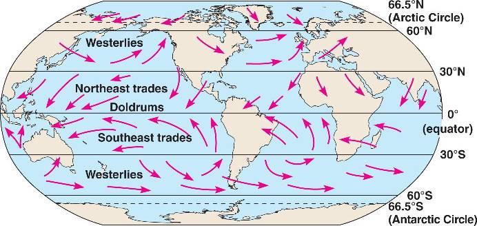
8 **************************************************************************************************************** MAP SECTION Figure 1 Global wind systems Figure 2 Wind zones Figure 3 Surface ocean currents Figure 4a and 4b World climates Figure 1. Global Wind Systems (H = high pressure cell; L = low pressure cell) Figure 2. Named Wind Zones with Latitude Markers. Arrows indicate predominant wind direction. 8

9 Figure 3. Surface ocean currents 9

10 Aw Figure 4a. World climate map (Köppen Classification System). Also consult map in textbook 10
.")
11 Figure 4b. World climate map (Köppen Classification System). Also consult map in textbook Exercise AFG 03/2019 rev 11
Thursday, November 3, 2016.
 Hunter College-CUNY GEOG 101 Atlas Extra Credit for Exam II The extra credit exercises associated with each third of the course are worth a maximum of 5 points added to your exam score at the end of each
Thursday, November 2, 2017.
 Hunter College-CUNY GEOG 101 Atlas Extra Credit for Exam II The extra credit exercises associated with each third of the course are worth a maximum of 5 points added to your exam score at the end of each
Tropical Moist Rainforest
 Tropical or Lowlatitude Climates: Controlled by equatorial tropical air masses Tropical Moist Rainforest Rainfall is heavy in all months - more than 250 cm. (100 in.). Common temperatures of 27 C (80 F)
Climate Classification Chapter 7
 Climate Classification Chapter 7 Climate Systems Earth is extremely diverse No two places exactly the same Similarities between places allow grouping into regions Climates influence ecosystems Why do we
Mediterranean Climates (Csa, Csb)
") Climatic Zones & Types Part II I've lived in good climate, and it bores the hell out of me. I like weather rather than climate. 1 John Steinbeck Mediterranean Climates (Csa, Csb) Main locations Western
Climatic Zones & Types Part II I've lived in good climate, and it bores the hell out of me. I like weather rather than climate. 1 John Steinbeck Mediterranean Climates (Csa, Csb) Main locations Western
Climate Classification
 Chapter 15: World Climates The Atmosphere: An Introduction to Meteorology, 12 th Lutgens Tarbuck Lectures by: Heather Gallacher, Cleveland State University Climate Classification Köppen classification:
Our climate system is based on the location of hot and cold air mass regions and the atmospheric circulation created by trade winds and westerlies.
 CLIMATE REGIONS Have you ever wondered why one area of the world is a desert, another a grassland, and another a rainforest? Or have you wondered why are there different types of forests and deserts with
CLIMATE DEFINED CLIMATE INFLUENCES STUDYING CLIMATE R E M I N D E R S. PART II: People and their 10/19/2018
 R E M I N D E R S Two required essays are due by Oct. 30, 2018. (A third may be used for extra credit in place of a Think Geographically essay.) ESSAY TOPIS (choose any two): ontributions of a noted geographer,
CLIMATE CLIMATE STUDYING CLIMATE. PART II: People and their 3/20/2018. GEOG 101 Part II People and their Physical Environment R E M I N D E R S
 Two required essays are due by March 27, 2018. (A third may be used for extra credit in place of a Think Geographically essay.) ESSAY TOPIS (choose any two): ontributions of a noted geographer, earth scientist
PART II. Physical Landscape Chapters 2 5 CLIMATE CLIMATE STUDYING CLIMATE R E M I N D E R S. PART II: People and their Physical Environment 10/26/2017
 R E M I N D E R S Two required essays are due by Nov. 13, 2017. (A third may be used for extra credit in place of a Think Geographically essay.) ESSAY TOPIS (choose any two): ontributions of a noted geographer,
Keys to Climate Climate Classification Low Latitude Climates Midlatitude Climates High Latitude Climates Highland Climates Our Changing Climate
 Climate Global Climates Keys to Climate Climate Classification Low Latitude Climates Midlatitude Climates High Latitude Climates Highland Climates Our Changing Climate Keys to Climate Climate the average
Energy Systems, Structures and Processes Essential Standard: Analyze patterns of global climate change over time Learning Objective: Differentiate
 Energy Systems, Structures and Processes Essential Standard: Analyze patterns of global climate change over time Learning Objective: Differentiate between weather and climate Global Climate Focus Question
Prentice Hall EARTH SCIENCE
 Prentice Hall EARTH SCIENCE Tarbuck Lutgens Chapter 21 Climate 21.1 Factors That Affect Climate Factors That Affect Climate Latitude As latitude increases, the intensity of solar energy decreases. The
GLOBAL CLIMATES FOCUS
 which you will learn more about in Chapter 6. Refer to the climate map and chart on pages 28-29 as you read the rest of this chapter. FOCUS GLOBAL CLIMATES What are the major influences on climate? Where
Earth s Climates. Understanding Weather and Climate. Chapter 15 Lecture. Seventh Edition
 Chapter 15 Lecture Understanding Weather and Climate Seventh Edition Earth s Climates Frode Stordal, University of Oslo Redina L. Herman Western Illinois University Climate and Controlling Factors Climate
Elements of weather and climate Temperature Range of temperature Seasonal temperature pattern Rainfall
 Climate Earth Science Chapter 20 Pages 560-573 Elements of weather and climate Temperature Range of temperature Seasonal temperature pattern Rainfall Overall rainfall Seasonal distribution of rainfall
L.O Students will learn about factors that influences the environment
 Name L.O Students will learn about factors that influences the environment Date 1. At the present time, glaciers occur mostly in areas of A) high latitude or high altitude B) low latitude or low altitude
Module 11: Meteorology Topic 3 Content: Climate Zones Notes
 Introduction Latitude is such an important climate factor that you can make generalizations about a location's climate based on its latitude. Areas near the equator or the low latitudes are generally hot
The Global Scope of Climate. The Global Scope of Climate. Keys to Climate. Chapter 8
 The Global Scope of Climate Chapter 8 The Global Scope of Climate In its most general sense, climate is the average weather of a region, but except where conditions change very little during the course
The following terms are some of the vocabulary that students should be familiar with in order to fully master this lesson.
 Lesson 501: LIMATE A location's climate is determined by the long-term pattern of temperature and precipitation. limate affects many aspects of our lives and cultures. Fundamental Questions Attempting
Prentice Hall EARTH SCIENCE
 Prentice Hall EARTH SCIENCE Tarbuck Lutgens Chapter 21 Climate 21.1 Factors That Affect Climate Factors That Affect Climate Latitude As latitude increases, the intensity of solar energy decreases. The
Climate. Earth Science Chapter 20 Pages
 Academic Excellence Showcase Thursday, May 27 Two points credit for each talk you attend in Earth science 8:30 to 10:30 AM, in NS 101 General Science video productions: Energy 9:00 to 11:00 AM, in NS 218
Adopt a Drifter Lesson Plan by Mary Cook, Middle School Science Teacher, Ahlf Jr. High School, Searcy, Arkansas
 Adopt a Drifter Lesson Plan by Mary Cook, Middle School Science Teacher, Ahlf Jr. High School, Searcy, Arkansas Do Ocean Surface Currents Influence Climate? Objectives Students will construct climographs
World Geography Chapter 3
 World Geography Chapter 3 Section 1 A. Introduction a. Weather b. Climate c. Both weather and climate are influenced by i. direct sunlight. ii. iii. iv. the features of the earth s surface. B. The Greenhouse
All objects emit radiation. Radiation Energy that travels in the form of waves Waves release energy when absorbed by an object. Earth s energy budget
 Radiation Energy that travels in the form of waves Waves release energy when absorbed by an object Example: Sunlight warms your face without necessarily heating the air Shorter waves carry more energy
1 What Is Climate? TAKE A LOOK 2. Explain Why do areas near the equator tend to have high temperatures?
 CHAPTER 17 1 What Is Climate? SECTION Climate BEFORE YOU READ After you read this section, you should be able to answer these questions: What is climate? What factors affect climate? How do climates differ
Physical Geography. Ariel view of the Amazon Rainforest. A Look at the Seven Continents
 Physical Geography In this unit you will learn about general physical geography. The study of the Earth s surface features provides the setting for the human-environmental interactions and for the human
CLIMATE DEFINED. PART II: People and their Physical Environment R E M I N D E R S 3/12/19
 R E M I N D E R S v Two required essays are due by April 9, 2019. Ø A third may be used for extra credit in place of a Think Geographically essay. ESSAY TOPICS (choose any two): Contributions of a noted
forest tropical jungle swamp marsh prairie savanna pampas Different Ecosystems (rainforest)
") Different Ecosystems forest A region of land that is covered with many trees and shrubs. tropical jungle (rainforest) swamp A region with dense trees and a variety of plant life. It has a tropical climate.
Different Ecosystems forest A region of land that is covered with many trees and shrubs. tropical jungle (rainforest) swamp A region with dense trees and a variety of plant life. It has a tropical climate.
World geography 3200/3202 Unit 2 review
 World geography 3200/3202 Unit 2 review 1. Does this statement use the terms revolve & rotate correctly? "Saturn revolves on its axis while several moons rotate around it." 2. Does this statement use the
16 Global Climate. Learning Goals. Summary. After studying this chapter, students should be able to:
 16 Global Climate Learning Goals After studying this chapter, students should be able to: 1. associate the world s six major vegetation biomes to climate (pp. 406 408); 2. describe methods for classifying
Contents. Section 1: Climate Factors. Section 2: Climate Types. Section 3: Climate Effects
 Contents Section 1: Climate Factors 1. Weather or Climate?.... 2 2. Elements of Climate.... 4 3. Factors Affecting Climate.... 10 4. Comparing Climates.... 15 5. Quiz 1.... 20 Section 2: Climate Types
Name Period Date. Analyzing Climographs
 Name Period Date Analyzing Climographs Climographs: It is often helpful to plot two different types of data on the same graph. For example, a climograph is a single graph that charts both the average temperature
Climate Chapter 19. Earth Science, 10e. Stan Hatfield and Ken Pinzke Southwestern Illinois College
 Climate Chapter 19 Earth Science, 10e Stan Hatfield and Ken Pinzke Southwestern Illinois College The climate system A. Climate is an aggregate of weather B. Involves the exchanges of energy and moisture
GEOGRAPHY 1114 LABORATORY EXAM Points possible LAB TIME/DAY 2 points per question CHOOSE THE BEST ANSWER IT SHOULD BE BEST BY FAR
 GEOGRAPHY 1114 LABORATORY EXAM 1 Spring 2011 NAME TEACHING ASSISTANT 50 Points possible LAB TIME/DAY 2 points per question CHOOSE THE BEST ANSWER IT SHOULD BE BEST BY FAR ANSWER ALL QUESTIONS IN PENCIL
LAB J - WORLD CLIMATE ZONES
 Introduction LAB J - WORLD CLIMATE ZONES The objective of this lab is to familiarize the student with the various climates around the world and the climate controls that influence these climates. Students
WHAT CAN MAPS TELL US ABOUT THE GEOGRAPHY OF ANCIENT GREECE? MAP TYPE 1: CLIMATE MAPS
 WHAT CAN MAPS TELL US ABOUT THE GEOGRAPHY OF ANCIENT GREECE? MAP TYPE 1: CLIMATE MAPS MAP TYPE 2: PHYSICAL AND/OR TOPOGRAPHICAL MAPS MAP TYPE 3: POLITICAL MAPS TYPE 4: RESOURCE & TRADE MAPS Descriptions
1 What Is Climate? TAKE A LOOK 2. Explain Why do areas near the equator tend to have high temperatures?
 CHAPTER 17 1 What Is Climate? SECTION Climate BEFORE YOU READ After you read this section, you should be able to answer these questions: What is climate? What factors affect climate? How do climates differ
Friday, February 23, 2018.
 Hunter College-CUNY GEOG 101 Extra Credit for Exam 1 Instructions The extra credit exercises associated with each third of the course are worth a maximum of 5 points added to your exam score at the end
Factors That Affect Climate
 Factors That Affect Climate Factors That Affect Climate Latitude As latitude (horizontal lines) increases, the intensity of solar energy decreases. The tropical zone is between the tropic of Cancer and
Lecture Outlines PowerPoint. Chapter 20 Earth Science 11e Tarbuck/Lutgens
 Lecture Outlines PowerPoint Chapter 20 Earth Science 11e Tarbuck/Lutgens 2006 Pearson Prentice Hall This work is protected by United States copyright laws and is provided solely for the use of instructors
Chapter 3 Section 3 World Climate Regions In-Depth Resources: Unit 1
 Guided Reading A. Determining Cause and Effect Use the organizer below to show the two most important causes of climate. 1. 2. Climate B. Making Comparisons Use the chart below to compare the different
IR-20: Weather/Climate Venn Diagram. Weather Climate Region 4 Education Service Center Geography by Design, Volume 1
 IR-20: Weather/Climate Venn Diagram Weather Climate 2013 Region 4 Education Service Center Geography by Design, Volume 1 IR-21: Climate Scenario Cards Scenario 1: You are on vacation at a location on the
1 What Is Climate? TAKE A LOOK 2. Explain Why do areas near the equator tend to have high temperatures?
 CHAPTER 3 1 What Is Climate? SECTION Climate BEFORE YOU READ After you read this section, you should be able to answer these questions: What is climate? What factors affect climate? How do climates differ
PART II. Physical Landscape Chapters 2 5 CLIMATE CLIMATE STUDYING CLIMATE R E M I N D E R S. PART II: People and their Physical Environment 10/19/2017
 R E M I N D E R S Two required essays are due by Nov. 13, 2017. (A third may be used for extra credit in place of a Think Geographically essay.) ESSAY TOPIS (choose any two): ontributions of a noted geographer,
PHYSICAL GEOGRAPHY. By Brett Lucas
 PHYSICAL GEOGRAPHY By Brett Lucas CLIMATIC ZONES AND TYPES Climatic Zones and Types Climatic Classification & Climographs Tropical Humid Climates (Zone A) Dry Climates (Zone B) Mild Midlatitude Climates
I. Definitions. A. Weather--day by day variations in temperature (temp), winds, pressure and precipitation (ppt)
, winds, pressure and precipitation (ppt)") CLIMATE UNIT I. Definitions A. Weather--day by day variations in temperature (temp), winds, pressure and precipitation (ppt) B. Climate--average seasonal weather for an area, usually described in terms
CLIMATE UNIT I. Definitions A. Weather--day by day variations in temperature (temp), winds, pressure and precipitation (ppt) B. Climate--average seasonal weather for an area, usually described in terms
Agronomy 406 World Climates
 Agronomy 406 World Climates March 1, 2018 A world tour of climates, including extremes (finish). Team 1 Climate News next Thursday, March 8 Review: Kottek et al. (2006): World map of the Köppen-Geiger
Wind: Global Systems Chapter 10
 Wind: Global Systems Chapter 10 General Circulation of the Atmosphere General circulation of the atmosphere describes average wind patterns and is useful for understanding climate Over the earth, incoming
Weather Atmospheric condition in one place during a limited period of time Climate Weather patterns that an area typically experiences over a long
 Weather Atmospheric condition in one place during a limited period of time Climate Weather patterns that an area typically experiences over a long period of time Many factors influence weather & climate
Class Notes: Water and Climate. Ever since the outgassing of water vapor years ago, Earth has been recycling its water supply. Water Cycle -!
 Name: Date: Period: Water and Climate The Physical Setting: Earth Science I. The Water Cycle Ever since the outgassing of water vapor years ago, Earth has been recycling its water supply Earth has not
Meteorology. Chapter 15 Worksheet 1
 Chapter 15 Worksheet 1 Meteorology Name: Circle the letter that corresponds to the correct answer 1) The Tropic of Cancer and the Arctic Circle are examples of locations determined by: a) measuring systems.
3) What is the difference between latitude and longitude and what is their affect on local and world weather and climate?
 What is the difference between latitude and longitude and what is their affect on local and world weather and climate?") www.discoveryeducation.com 1) Describe the difference between climate and weather citing an example of each. Describe how water (ocean, lake, river) has a local effect on weather and climate and provide
www.discoveryeducation.com 1) Describe the difference between climate and weather citing an example of each. Describe how water (ocean, lake, river) has a local effect on weather and climate and provide
Unit 2. United States Physical Geography
 Unit 2 United States Physical Geography Physical Geography U.S. extends from the Atlantic to Pacific U.S. is the 3rd largest country U.S. has fertile soils, vast forests, and variety of minerals All major
CORE CONCEPTS WEATHER AND CLIMATE
 CORE CONCEPTS WEATHER AND CLIMATE Key Prior Knowledge (from the 5 th Grade Matter and Energy Units) Thermal energy can be transported through radiation, conduction, and convection. The transfer of enough
Seasons, Global Wind and Climate Study Guide
 Seasons, Global Wind and Climate Study Guide Seasons 1. Know what is responsible for the change in seasons on Earth. 2. Be able to determine seasons in the northern and southern hemispheres given the position
Bell Work. REVIEW: Our Planet Earth Page 29 Document A & B Questions
 9.12.16 Bell Work REVIEW: Our Planet Earth Page 29 Document A & B Questions Intro to Climate & Weather https://www.youtube.com/watch?v=vhgyoa70q7y Weather vs. Climate Video Climate & Weather 3.1 Weather
Homework. Oceanography and Climate Review due Friday Feb 12 th (test day!!)
") Homework Oceanography and Climate Review due Friday Feb 12 th (test day!!) Learning Targets I can define the term climate and explain the factors that influence the climate of an area. I can identify the
Homework Oceanography and Climate Review due Friday Feb 12 th (test day!!) Learning Targets I can define the term climate and explain the factors that influence the climate of an area. I can identify the
Name Class Date. 2. What is the average weather condition in an area over a long period of time called? a. winter b. temperature c. climate d.
 Skills Worksheet Directed Reading B Section: What Is Climate? CLIMATE VS. WEATHER 1. What kind of conditions vary from day to day? a. climate b. weather c. latitude d. biome 2. What is the average weather
Global Wind Patterns
 Name: Earth Science: Date: Period: Global Wind Patterns 1. Which factor causes global wind patterns? a. changes in the distance between Earth and the Moon b. unequal heating of Earth s surface by the Sun
What is Climate? Understanding and predicting climatic changes are the basic goals of climatology.
 What is Climate? Understanding and predicting climatic changes are the basic goals of climatology. Climatology is the study of Earth s climate and the factors that affect past, present, and future climatic
Name: Climate Date: EI Niño Conditions
 Name: Date: Base your answers to questions 1 and 2 on the maps and the passage below. The maps show differences in trade wind strength, ocean current direction, and water temperature associated with air-pressure
Grade 9 Geography Chapter 11 - Climate Connections
 Grade 9 Geography Chapter 11 - Climate Connections 1. Define: Weather. 2. In what way has weather affected your activities in the last two weeks? 3. Define: Climate. 4. Canada s climate is a function of
Name Date Class. well as the inland, found near the Tropics. 4. In the, or the regions near the Equator, you may find a lush
 WATER, CLIMATE, AND VEGETATION Vocabulary Activity DIRECTIONS: Fill in the Blanks Select a term from below to complete each of the following sentences. CHAPTER 1. The constant movement of water, a process
Latitude & Longitude. Worksheets & activities to teach latitude & longitude. Includes notes, activities, review & all answer keys. 11 pages!
 Latitude & Longitude Worksheets & activities to teach latitude & longitude. Includes notes, activities, review & all answer keys. 11 pages! Lines of Latitude & Longitude Name: Lines of latitude and longitude
1. Match the words in the first column to the meaning in the second column. [5]
![1. Match the words in the first column to the meaning in the second column. [5]](/thumbs/96/126839765.jpg "1. Match the words in the first column to the meaning in the second column. [5]") Exercise 1: [40 POINTS] 1. Match the words in the first column to the meaning in the second column. [5] Equator Around earth between the Equator and the Poles. Greenwich meridian Half of earth. Longitude
Exercise 1: [40 POINTS] 1. Match the words in the first column to the meaning in the second column. [5] Equator Around earth between the Equator and the Poles. Greenwich meridian Half of earth. Longitude
Mid-latitude Cyclones & Air Masses
 Lab 9 Mid-latitude Cyclones & Air Masses This lab will introduce students to the patterns of surface winds around the center of a midlatitude cyclone of low pressure. The types of weather associated with
AIR MASSES SOURCE REGION CHARACTERISTICS Continental Arctic (ca) Greenland, Antarctica, Highest latitudes of Asia and North America
 Greenland, Antarctica, Highest latitudes of Asia and North America") GEOGRAPHY CLIMATOLOGY AIRMASS, FRONT AND TEMPERATE CYCLONE AIRMASS A large body of air having little horizontal variation in temperature and moisture is called an airmass. Airmass acquires its properties
GEOGRAPHY CLIMATOLOGY AIRMASS, FRONT AND TEMPERATE CYCLONE AIRMASS A large body of air having little horizontal variation in temperature and moisture is called an airmass. Airmass acquires its properties
SECTION II. The Physical World: The Earth, Climate and Water. Page 2-1
 SECTION II The Physical World: The Earth, Climate and Water Page 2-1 Page 2-2 Introduction The Earth Assignment The shape of the earth is in large part a product of billions of years of plate tectonic
CLIMATE. UNIT TWO March 2019
 CLIMATE UNIT TWO March 2019 OUTCOME 9.2.1Demonstrate an understanding of the basic features of Canada s landscape and climate. identify and locate major climatic regions of Canada explain the characteristics
Average temperature ( F) World Climate Zones. very cold all year with permanent ice and snow. very cold winters, cold summers, and little rain or snow
 World Climate Zones. very cold all year with permanent ice and snow. very cold winters, cold summers, and little rain or snow") P r e v i e w Look carefully at the climagraph of Mumbai, India. What is the wettest month (or months) in Mumbai? What is the driest month (or months) in Mumbai? What effects might this city s climate
P r e v i e w Look carefully at the climagraph of Mumbai, India. What is the wettest month (or months) in Mumbai? What is the driest month (or months) in Mumbai? What effects might this city s climate
Factors that Affect Climate
 Factors that Affect Climate What is climate? Climate is the average weather conditions over a long period of time Includes average temperatures and precipitation, wind patterns, humidity, air pressure
What factors affect climate? Dr. Michael J Passow
 What factors affect climate? Dr. Michael J Passow Energy from the Sun (mostly light and heat) radiates to Earth SUN 150 x 10 6 km (92 x 10 6 mi) EARTH Challenge: If the speed of light is 300,000 km/sec,
Name Period Part I: INVESTIGATING OCEAN CURRENTS: PLOTTING BUOY DATA
 Name Period Part I: INVESTIGATING OCEAN CURRENTS: PLOTTING BUOY DATA INTRODUCTION: Ocean currents are like huge rivers in the sea. They carry drifting organisms, vital dissolved chemical nutrients and
3. The map below shows an eastern portion of North America. Points A and B represent locations on the eastern shoreline.
 1. Most tornadoes in the Northern Hemisphere are best described as violently rotating columns of air surrounded by A) clockwise surface winds moving toward the columns B) clockwise surface winds moving
Overview. 1 - Previous Eras 2 - Africa's current climate
 Marine Science Lesson Enhancements based on Grade 11 & 12 curriculum in Physics, Chemistry & Biology Climate African climate Ocean Explorer Module 6 Copyright 2017 Climate part 2 Page! 1 of! 13 Overview
2. Identify each of the following statements as a reference to weather or climate.
 World Geography 3200/3202 Unit 2 Questions Name: Read Pages 54-55 1. Explain the difference between Weather and Climate. 2. Identify each of the following statements as a reference to weather or climate.
ATSC 2000 Final Fall 2005
 ATSC 2000 Final Fall 2005 true/false /25 multiple choice /25 short answer /23 essay /10 total /83 or % True/False Indicate whether the sentence or statement is true or false. (25 questions 1% each) 1.
Climates of Earth. Lesson Outline LESSON 1. A. What is climate? 1. is the long-term average weather conditions that occur in a particular region.
 Lesson Outline LESSON 1 A. What is climate? 1. is the long-term average weather conditions that occur in a particular region. 2. Climate depends on how average weather conditions throughout the year. B.
Name: Regents Earth Science. Weather and Climate - Review Questions
 Name: Regents Earth Science Weather and Climate - Review Questions Date: Thayer - 279 1. People sometimes release substances into the atmosphere to increase the probability of rain by A) raising the air
World Climates. Say Thanks to the Authors Click (No sign in required)
") World Climates Say Thanks to the Authors Click http://www.ck12.org/saythanks (No sign in required) To access a customizable version of this book, as well as other interactive content, visit www.ck12.org
World Climates Say Thanks to the Authors Click http://www.ck12.org/saythanks (No sign in required) To access a customizable version of this book, as well as other interactive content, visit www.ck12.org
Unit 2 Text Worksheet # 2
 Unit 2 Text Worksheet # 2 Read Pages 74-77 1. Using fig. 5.1 on page 75 identify: Climatic Region the most widespread climatic region in the low latitudes two climatic subregions with dry conditions for
Chapter 21 Southwest Asia: Harsh & Arid Lands
 Name Hour Chapter 21 Southwest Asia: Harsh & Arid Lands Essential Question: How has the physical geography of Asia influenced the development of these regions (i.e. history, population distribution, &
Chapter 1 Section 2. Land, Water, and Climate
 Chapter 1 Section 2 Land, Water, and Climate Vocabulary 1. Landforms- natural features of the Earth s land surface 2. Elevation- height above sea level 3. Relief- changes in height 4. Core- most inner
A. Spatial Sense (Working with Maps, Globes, and Other Geographic Tools)
") A. Spatial Sense (Working with Maps, Globes, and Other Geographic Tools) Measuring Distance Using Map Scale All maps are drawn to scale; that is, they are smaller than the things they represent. Scale
A. Spatial Sense (Working with Maps, Globes, and Other Geographic Tools) Measuring Distance Using Map Scale All maps are drawn to scale; that is, they are smaller than the things they represent. Scale
Energy and Seasons A B1. 9. Which graph best represents the general relationship between latitude and average surface temperature?
 Energy and Seasons A B1 1. Which type of surface absorbs the greatest amount of electromagnetic energy from the Sun? (1) smooth, shiny, and light colored (2) smooth, shiny, and dark colored (3) rough,
Unit 2 Outcome Notes. Nightly cloud cover reduces the range of temperature from day to night.
 1 Unit 2 Outcome Notes C.O. 2.1 2.6 Cloud Cover Affects Daily & Nightly Temperatures Nightly cloud cover reduces the range of temperature from day to night. o Clouds reflect heat waves; o heat below clouds
remain on the trees all year long) Example: Beaverlodge, Alberta, Canada
 Example: Beaverlodge, Alberta, Canada") Coniferous Forest Temperature: -40 C to 20 C, average summer temperature is 10 C Precipitation: 300 to 900 millimeters of rain per year Vegetation: Coniferous-evergreen trees (trees that produce cones
Coniferous Forest Temperature: -40 C to 20 C, average summer temperature is 10 C Precipitation: 300 to 900 millimeters of rain per year Vegetation: Coniferous-evergreen trees (trees that produce cones
LAB 19. Lab 19. Differences in Regional Climate: Why Do Two Cities Located at the Same Latitude and Near a Body of Water Have Such Different Climates?
 Lab Handout Lab 19. Differences in Regional Climate: Why Do Two Cities Located at the Same Latitude and Near a Body of Water Have Such Different Climates? Introduction Weather describes the current atmospheric
1. Which weather map symbol is associated with extremely low air pressure? A) B) C) D) 2. The diagram below represents a weather instrument.
 B) C) D) 2. The diagram below represents a weather instrument.") 1. Which weather map symbol is associated with extremely low air pressure? 2. The diagram below represents a weather instrument. Which weather variable was this instrument designed to measure? A) air pressure
1. Which weather map symbol is associated with extremely low air pressure? 2. The diagram below represents a weather instrument. Which weather variable was this instrument designed to measure? A) air pressure
ENVIRONMENTS and LIFE
 ENVIRONMENTS and LIFE part III The Terrestrial Realm Notes from (Stanley and Luczaj, 2015) Earth System History, Chapter 4 Alessandro Grippo, Ph.D. A lynx, or bobcat, in the suburban Los Angeles chaparral
Project Retrograde imagine Earth rotated in the opposite direction
 Project Retrograde imagine Earth rotated in the opposite direction The rotation of Earth shapes our climate system in various ways: It controls the major wind directions, lets the weather systems swirl,
Exploring Climate Influences
 Exploring Climate Influences Purpose Students are able to identify the influence of latitude, elevation, proximity to water and physical features on their local climate by analyzing 30 years of monthly
Climate and the Atmosphere
 Climate and Biomes Climate Objectives: Understand how weather is affected by: 1. Variations in the amount of incoming solar radiation 2. The earth s annual path around the sun 3. The earth s daily rotation
Physical Geography Lab Activity #16
 Physical Geography Lab Activity #16 Due date Name California Climate Classification COR Objective 6, SLO 3 16.1. Introduction One of the most important factors in the physical geography of a place is its
Fig Major air masses of the world
 Fig. 9.3 Major air masses of the world CLASSIFICATION FOUR BASIC CATEGORIES OF AIR MASSES: POLAR - P ARCTIC - A TROPICAL - T EQUATORIAL - E TWO DESIGNATIONS OF SURFACE IN SOURCE REGION MARITIME - m. CONTINENTAL
Objectives. Vocabulary. Describe different types of climate data. Recognize limits associated with the use of normals. Explain why climates vary.
 Climate Objectives Describe different types of climate data. Recognize limits associated with the use of normals. Explain why climates vary. Vocabulary climatology climate normal tropics temperate zone
Climate. Fact sheet 16 World climates. National Meteorological Library and Archive
 Climate Fact sheet 16 World climates National Meteorological Library and Archive The National Meteorological Library and Archive Many people have an interest in the weather and the processes that cause
Guided Reading Activity
 Guided Reading Activity Lesson 1 Physical Features Essential Question: How does geography influence the way people live? A Vast Land Directions: Read the lesson and use your text to decide whether each