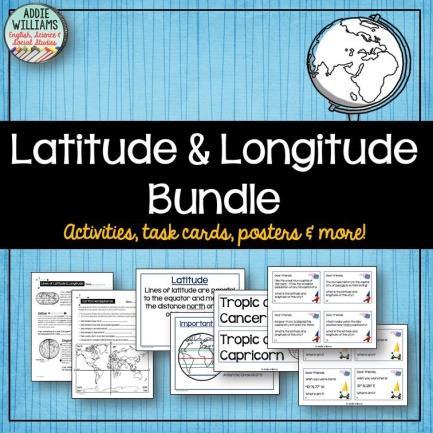
Latitude & Longitude. Worksheets & activities to teach latitude & longitude. Includes notes, activities, review & all answer keys. 11 pages!
|
|
|
- Joseph Baker
- 6 years ago
- Views:
Transcription


1 Latitude & Longitude Worksheets & activities to teach latitude & longitude. Includes notes, activities, review & all answer keys. 11 pages!


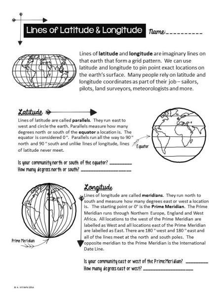
2 Lines of Latitude & Longitude Name: Lines of latitude and longitude are imaginary lines on that earth that form a grid pattern. We can use latitude and longitude to pin point exact locations on the earth s surface. Many people rely on latitude and longitude coordinates as part of their job sailors, pilots, land surveyors, meteorologists and more. Latitude Lines of latitude are called parallels. They run east to west and circle the earth. Parallels measure how many degrees north or south of the equator a location is. The equator is considered 0. Parallels run all the way to 90 north and 90 south and unlike lines of longitude, lines of latitude never meet. Equator Is your community north or south of the equator? How many degrees north or south? Prime Meridian Longitude Lines of longitude are called meridians. They run north to south and measure how many degrees east or west a location is. The starting point or 0 is the Prime Meridian. The Prime Meridian runs through Northern Europe, England and West Africa. All locations to the west of the Prime Meridian are labelled as West and all locations east of the Prime Meridian are labelled as East. There are 180 west and 180 east and all of the lines meet at the north and south poles. The opposite meridian to the Prime Meridian is the International Date Line. Is your community east or west of the Prime Meridian? How many degrees east or west?
3 Lines of Latitude Name: There are several important lines of latitude on the earth that are based on the angle and position of the sun at different times of the year. The Equator The equator circles the earth at its half way point and divides it into the Northern and Southern Hemispheres. The equator marks the point where the sun is directly overhead on the equinoxes (March 21 st and September 21 st ) Name three countries the Equator crosses: Tropic of Cancer & Tropic of Capricorn The Tropic of Cancer is located at 23.5 N and marks the point on the earth s surface where the sun is directly overhead on the summer solstice. (June 21 st ) Name three countries the Tropic of Cancer crosses: The Tropic of Capricorn is located at 23.5 S and marks the point on the earth s surface where the sun is directly overhead on the winter solstice (December 21 st ) Name three countries the Tropic of Capricorn crosses: The Arctic & Antarctic Circle The Arctic Circle is located at 66.5 N and the Antarctic Circle is located at 66.5 S. On the summer solstice (June 21 st ) the area north of the Arctic Circle receives 24 hours of sunlight. The areas south of the Antarctic Circle receive 0 hours of sunlight. The opposite happens on the winter solstice. (December 21 st )
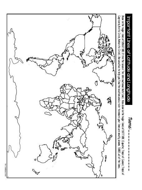
4 Important Lines of Latitude and Longitude Name: Draw in the major line of LONGITUDE (Prime Meridian). Also draw in the major lines of LATITUDE (Equator, Tropic of Cancer, Tropic of Capricorn, Arctic Circle, Antarctic Circle). Use an atlas to help you find the location and a ruler to ensure your lines are neatly drawn. LABEL all of the lines.
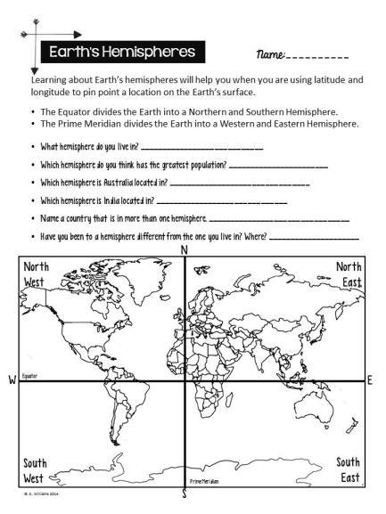
5 Earth s Hemispheres Name: Learning about Earth s hemispheres will help you when you are using latitude and longitude to pin point a location on the Earth s surface. The Equator divides the Earth into a Northern and Southern Hemisphere. The Prime Meridian divides the Earth into a Western and Eastern Hemisphere. What hemisphere do you live in? Which hemisphere do you think has the greatest population? Which hemisphere is Australia located in? Which hemisphere is India located in? Name a country that is in more than one hemisphere. Have you been to a hemisphere different from the one you live in? Where? North West N North East W Equator E South West S Prime Meridian South East
6 Using Latitude & Longitude Name: The lines of latitude and longitude are laid out in a grid on the earth s surface. When you know the latitude and longitude you can easily locate an exact spot. For example, if I asked you where Los Angeles is located you might answer In the United States. However, the United States is a very large country and your answer does not give me an exact location. If you gave me the coordinates, 34 N 118 W, I would be able to pin point its exact location. First off, I would know it s in the North West hemisphere and secondly, I would know it s 34 N of the Equator and 118 W of the Prime Meridian. To find Los Angeles, start at the Equator and move your finger north 34 (you will have to estimate this as it is impossible to include all of the lines on the map). Then starting at the Prime Meridian move your finger west 118. Where the two lines meet and intersect is where Los Angeles is located it s marked on the map below with a Draw a circle on the following locations: a) 30 S, 118 E b) 50 S, W c) 50 N, 50 W
7 Using Latitude & Longitude Name: Use an atlas to help you answer the following questions: 1. In which country is 65 N, 110 E? 2. In what ocean is 5 S, 150 W? 3. In which bay is N, 82 W? 4. In what sea is 38 S, 162 E? 5. On which island is 65 N, 18 W? 6. In which country is 15 S, 45 W? 7. In which country is 32 S, 25 E? 8. In which country is 25 N, 85 E?
8 Finding Latitude & Longitude Name: Using the map below, write down the latitude and longitude for the letters B-H on the map. A. 25 N, 145 W B. C. D. E. F. G. H. A. B. D. F. G. 0 C.. E H


9 Latitude & Longitude Review Name: A. Using an atlas to help, write down the latitude and longitude for the following major world cities. 1. Sydney, Australia 2. New York, United States 3. Cape Town, South Africa 4. Santiago, Chile 5. Rome, Italy 6. Beijing, China 7. New Delhi, India 8. Paris, France 9. Ottawa, Canada 10. Mexico City, Mexico B. Using an atlas to help, locate the following major world cities using the coordinates given S, 153 E N, 97 W N, 150 W S, 116 E N, 1 E S, 77 W N, 9 W 8. 1 S, 37 E 9. 6 S, 107 E S, 58 W Without geography, you are nowhere. Unknown
10 Using Latitude & Longitude Answer Key Use an atlas to help you answer the following questions: 1. In which country is 65 N, 110 E? Russia 2. In what ocean is 5 S, 150 W? Pacific Ocean 3. In which bay is N, 82 W? Hudson s Bay 4. In what sea is 38 S, 162 E? Tasman Sea 5. On which island is 65 N, 18 W? Iceland 6. In which country is 15 S, 45 W? Brazil 7. In which country is 32 S, 25 E? South Africa 8. In which country is 25 N, 85 E? India
11 Latitude & Longitude Review Answer Key A. Using an atlas to help, write down the latitude and longitude for the following major world cities. 1. Sydney, Australia 34 S, 151 E 2. New York, United States 41 N, 74 W 3. Cape Town, South Africa 34 S, 18 E 4. Santiago, Chile 33 S, 71 W 5. Rome, Italy 42 N, 13 E 6. Beijing, China N, 116 E 7. New Delhi, India 28 N, 77 E 8. Paris, France 49 N, 2 E 9. Ottawa, Canada 45 N, 76 W 10. Mexico City, Mexico 19 N, 99 W B. Using an atlas to help, locate the following major world cities using the coordinates given S, 153 E Brisbane, Australia N, 97 W Dallas, United States N, 150 W Anchorage, United States S, 116 E Perth, Australia N, 1 E Tokyo, Japan S, 77 W Lima, Peru N, 9 W Lisbon, Portugal 8. 1 S, 37 E Nairobi, Kenya 9. 6 S, 107 E Jakarta, Indonesia S, 58 W Buenos Aires, Argentina Without geography, you are nowhere. Unknown
12 Finding Latitude & Longitude Answer Key I allow my students lots of room in their answers it s a small map and difficult to be exact. A. 25 N, 145 W B. 52 N, 65 W C. 10 S, 45 W D. 70 N, 10 W E. 30 S, E F. 35 N, 110 E G. 65 N, 150 E H. 25 S, 150 E A. B. D. F. G. 0 C.. E H


13 Thanks so much! Check out more of my products on TpT by clicking the images below.


 is")


14 Many thanks to the following talented artists! Thanks so much! Follow me to keep updated on new products! Terms of Use Copying any part of this product and placing it on the internet in any form (even a personal / classroom website) is forbidden and is a violation of the Digital Millennium Copyright Act (DMCA). These items can be picked up in a search and downloaded for free if not secured. This item is meant for single classroom use only please do not distribute to others. Thanks so much for respecting copyright ~Addie Williams
Module 2: Mapping Topic 2 Content: Determining Latitude and Longitude Notes
 Introduction In order to more easily locate points on a globe or map, cartographers designed a system of imaginary vertical lines (also called parallels) and horizontal lines (also called meridians) that
Map Skills Lesson 1. Materials: maps, pencils, Lesson 1 Worksheet, strips of paper, grid paper
 Map Skills Lesson 1 Use cardinal directions, map grids, scales, and titles to locate places on a map. Interpret a map using information from its title, compass rose, scale, and legend. Vocabulary: map,
Latitude & Longitude Study Guide
 Latitude & Longitude Study Guide Name: Date: Section: Label the important Latitude lines on the diagram below. Include the degree measurements The equator is located at zero degrees latitude. The equator
SAMPLE. Succeeding in Social Studies 5 6 TH IN A SERIES OF 7. Years 5 9. Written by Valerie Marett. CORONEOS PUBLICATIONS Item No 508
 AUSTRALIAN HOMESCHOOLING SERIES Succeeding in Social Studies 5 6 TH IN A SERIES OF 7 Years 5 9 Written by Valerie Marett CORONEOS PUBLICATIONS Item No 508 Contents Notes to Parents.2 Latitude and Longitude...3
Globes, Maps, and Atlases. Plus, A Whole Bunch of Other Way Cool Geographic Information!!!
 Globes, Maps, and Atlases Plus, A Whole Bunch of Other Way Cool Geographic Information!!! Globes Are the Most Accurate Portrayal of the Earth The earth is about 24,900 miles in circumference, and about
The Earth-Moon-Sun System
 chapter 7 The Earth-Moon-Sun System section 2 Time and Seasons What You ll Learn how to calculate time and date in different time zones how to distinguish rotation and revolution what causes seasons Before
CHAPTER 2 SKILL SHEET 2: CELESTIAL NAVIGATION
 CHAPTER 2 SKILL SHEET 2: CELESTIAL NAVIGATION Before the invention of GPS technology, how were people on ships far at sea, out of the sight of land, able to tell where they were? For thousands of years
IR-4: Classroom Grid Region 4 Education Service Center Geography by Design, Volume 1
 IR-4: Classroom Grid 2013 Region 4 Education Service Center Geography by Design, Volume 1 IR-5: Latitude/Longitude Coordinates Location Latitude Longitude 35 N 139 E 11 N 104 E 1 N 103 E 18 N 72 E 59 N
Cardinal and Intermediate Directions:
 Name Period Parent Signature Due Date: (TBA) Geography/Map Skills Study Guide Continents and Oceans of the World: Label the continents (7) and oceans (4) on the lines below the map. 1 11 3 5 4 8 2 9 10
LAB C - GEOGRAPHIC GRID AND TIME
 Introduction LAB C - GEOGRAPHIC GRID AND TIME In this lab the student will learn to determine latitude and longitude, to plot the location of various places on a geographic grid, and to calculate the difference
Phase 1 Cards. Phase 1. Phase 1. How many picnic areas does the park have? Write the answer near the legend.
 S T U D E N T H A N D O U T F Cards Write the map s title in the northwest corner above the map. How many picnic areas does the park have? Write the answer near the legend. 1 2 Draw a compass rose near
Student Handout. Write the map s title in the northwest corner of the map. How many picnic areas does the park have? Write the answer near the legend.
 Student Handout 1F Cards Write the map s title in the northwest corner of the map. How many picnic areas does the park have? Write the answer near the legend. 1 2 Draw a compass rose near the west edge
Geography Class 6 Chapters 3 and
 CHAPTER 3 MOTIONS OF THE EARTH The Earth is always travelling in Space. That makes each person on Earth, a Space Traveller. No one feels the movement of the Earth because humans are too tiny when compared
The Coordinate System
 5 The Coordinate System Key Words: latitude, degrees, longitude, prime meridian, absolute location You can locate any place on Earth by using a special set of numbers. These numbers are part of a set of
GEOGRAPHY STD.9 LATITUDE & LONGITUDE
 GEOGRAPHY STD.9 LATITUDE & LONGITUDE 1. What is the Earth Grid? A. The complete network of meridians & parallels is called the earth Grid. 2. What is Latitude? A. The latitude of a place is the distance
 Name Period Parent Signature Geography/Map Skills Study Guide *For extra practice with these skills, check out Mr. Kath s website: http://rkath.weebly.com/activities--links.html Continents and Oceans of
2. What does the map scale tell the map reader? a ratio between the actual distance on the ground and the length given to that distance on a map
 AP Human Geography - Damon Name Unit 1 - Intro to Human Geography Hour Map and Globe Skills Review Note: All links in this packet are found on our Wikispace under Map and Globe Skills Review First, read
Complete the following: a. Lines of latitude are parallel to the equator. Name:
 Name: Date: Social Studies Introduction: Basic Geography Period: Latitude Latitude is defined as a measurement of distance in degrees north and south of the equator. The word latitude is derived from the
Map Skills Unit. Note taking unit
 Map Skills Unit Note taking unit Introduction To learn about the Earth, we are going to learn about two geographic tools you can use.globes and maps. Globe A globe is a round model of the planet Earth
Geographic Grid -Latitudes and Longitudes
 GEOGRAPHY STD 9 Geographic Grid -Latitudes and Longitudes 2018-2019 Q1. Define Geographic Grid. The network of latitudes and longitudes are known as Geographic Grid. They help us to locate places on the
Map Skills and Geographic Tools
 Name: Period: Map Skills and Geographic Tools TEKS: 8.9C interpret topographic maps and satellite views to identify land and erosional features and predict how these features may be reshaped by weathering
THE EARTH AND ITS REPRESENTATION
 UNIT 7 THE EARTH AND ITS REPRESENTATION TABLE OF CONTENTS 1 THE EARTH AND THE SOLAR SYSTEM... 2 2 THE EARTH S MOVEMENTS... 2 2.1 Rotation.... 2 2.2 The revolution of the Earth: seasons of the year....
Map Skills Scavenger Hunt
 Map Skills Scavenger Hunt Introduction to: Continents Cardinal Directions Relative Location Equator and Prime Meridian Hemispheres Reading a Political Map Reading a Physical Map Idea: This product includes
01) The Sun s rays strike the surface of the Earth at 90 degrees at the on December 22.
 The Sun s rays strike the surface of the Earth at 90 degrees at the on December 22.") Package Title: Testbank Course Title: Introducing Physical Geography 6e Chapter Number: 01 Question Type: Multiple Choice 01) The Sun s rays strike the surface of the Earth at 90 degrees at the on December
Package Title: Testbank Course Title: Introducing Physical Geography 6e Chapter Number: 01 Question Type: Multiple Choice 01) The Sun s rays strike the surface of the Earth at 90 degrees at the on December
Latitude and Longitude. Begin
 Latitude and Longitude Begin The Earth is divided in two halves, the top half is called the northern hemisphere, and the bottom half is called the southern hemisphere. The dividing line between the two
YEAR 5 SUMMER EXAM REVISION QUESTIONS
 NAME: FORM: YEAR 5 SUMMER EXAM REVISION QUESTIONS 2017 YEAR 5 SUMMER EXAM REVISION QUESTIONS The exam will be forty minutes long. Answers will be short sentences or just oneword answers. The exam will
Astronomy 101 Exam 1 Form A
 Astronomy 101 Exam 1 Form A Name: Lab section number: (In the format M0**. See back page; if you get this wrong you may not get your exam back!) Exam time: one hour and twenty minutes Please put bags under
... Europe. Based on Bloom s Taxonomy. Environment Interactions Movement. Human & Location. Regions. Place
 ... Europe Location Place Human & Environment Interactions Movement Regions LEVEL 1 Knowledge Match Show or Label List Information Recall Details (5Ws + H) Find Information LEVEL 2 Comprehension Describe
Introduction to Geography
 Introduction to Geography ropic of Cancer 3½ N Arctic Circle 90 N Prime Meridian 0 Arctic Ocean Mississippi R. Appalachian Mts. Europe Rocky Mountains N. America Atlantic Gulf of Ocean Mexico Caribbean
GRADE 6 GEOGRAPHY TERM 1 LATITUDE AND LONGITUDE (degrees)
") 1 GRADE 6 GEOGRAPHY TERM 1 LATITUDE AND LONGITUDE (degrees) Contents Lines of Latitude... 2 Lines of Longitude... 3 The hemispheres of The Earth... 4 Finding countries and cities on a map using latitude
1 GRADE 6 GEOGRAPHY TERM 1 LATITUDE AND LONGITUDE (degrees) Contents Lines of Latitude... 2 Lines of Longitude... 3 The hemispheres of The Earth... 4 Finding countries and cities on a map using latitude
Daylight, Latitude, and Traditional Japanese Clocks
 The School and University Partnership for Educational Renewal in Mathematics An NSF-funded Graduate STEM Fellows in K 12 Education Project University of Hawai i at Manoa, Department of Mathematics Daylight,
Latitudes and Longitudes
 Latitudes and Longitudes Angles are used to label latitudes and longitudes in order to locate points on our planet. It is a known fact that the earth is approximately a big sphere with a radius that is
1. Match the words in the first column to the meaning in the second column. [5]
![1. Match the words in the first column to the meaning in the second column. [5]](/thumbs/96/126839765.jpg "1. Match the words in the first column to the meaning in the second column. [5]") Exercise 1: [40 POINTS] 1. Match the words in the first column to the meaning in the second column. [5] Equator Around earth between the Equator and the Poles. Greenwich meridian Half of earth. Longitude
Exercise 1: [40 POINTS] 1. Match the words in the first column to the meaning in the second column. [5] Equator Around earth between the Equator and the Poles. Greenwich meridian Half of earth. Longitude
Geographic Grid. Locations Feature 1 Feature 2 Feature 3
 Geographic Grid Name The geographic grid refers to the internationally-recognized system of latitude and longitude used to location positions on Earth's surface. Accurate use of this coordinate system
Downloaded from
 Geo Globe : Latitudes and Longitudes 1.Suppose the time at 30 east is 2 p.m. then what is the time at Greenwich? (A) 2 p.m. (B) 12 p.m. (C) 1 p.m. (D) Cannot find 2.What does the term 'Grid' mean
(1) Over the course of a day, the sun angle at any particular place varies. Why?
 Over the course of a day, the sun angle at any particular place varies. Why?") (1) Over the course of a day, the sun angle at any particular place varies. Why? (Note: Although all responses below are true statements, only one of them actually explains the observation!) (A)The sun
(1) Over the course of a day, the sun angle at any particular place varies. Why? (Note: Although all responses below are true statements, only one of them actually explains the observation!) (A)The sun
Section. 1 Our Planet, Earth. Prepare to Read
 1 Section Step-by-Step Instruction Objectives Social Studies 1. Learn about Earth s movement in relation to the sun. 2. Explore seasons and latitude. Reading/Language Arts Use context clues from surrounding
7a LATITUDE LONGITUDE.notebook. September 19, 2017
 1 PANGEA Add a pangea link to here 2 There are 4 hemispheres Hemispheres are divided using the Equator (north and south) and Prime Meridian (west and east) 3 4 Northern Hemisphere Equator SOUTHERN OCEAN
Name Date. What s the weather like today? Watch the beginning of the video Basics of geography- climate.
 FACTORS THAT INFLUENCE CLIMATE worksheet 1 STARTER Look at the weather symbols and answer: What s the weather like today? WHAT S CLIMATE? Watch the beginning of the video Basics of geography- climate.
European Union Can you label the twenty-seven countries of the EU on the map attached? (Do not revise the capitals.)
") NAME: FORM: YEAR 5 SUMMER EXAM REVISION QUESTIONS 2016 The exam will be forty minutes long. Answers will be short sentences or just one-word answers. The exam will be based upon the work that you have
NAME: FORM: YEAR 5 SUMMER EXAM REVISION QUESTIONS 2016 The exam will be forty minutes long. Answers will be short sentences or just one-word answers. The exam will be based upon the work that you have
AP Human Geography World Atlas Project
 AP Human Geography World Atlas Project - 2018 Welcome to Robert E. Lee High School and Advanced Placement Human Geography! You are going to thoroughly enjoy this class. It will be a lot of work, but the
EARTH S REVOLUTION -and- EARTH S ROTATION
 EARTH S REVOLUTION -and- EARTH S ROTATION Earth s Revolution Have you ever noticed that your classroom globe is tilted? This is no accident. Globes are made to be replicas, or models, of the Earth. Earth
Unit 2 Study Guide: The World in Spatial Terms
 Name Date Hour Unit 2 Study Guide: The World in Spatial Terms TEST is WEDNESDAY, DECEMBER 19 TH This study guide contains all the concepts that will be on your test. Vocabulary words and concepts will
The Earth and its representation
 GEOGRAPHY UNIT 1 The Earth and its representation THE SOLAR SYSTEM AND THE EARTH THE SOLAR SYSTEM The solar system is a planetary system. Is a group of astronomical objects who surround a star, in this
Chapter 1 Test on Geography Skills
 Name Score Chapter 1 Test on Geography Skills Part 1 Matching (14 pts.) Match each term in Column B with its correct definition in Column A by clearly writing the number in the blank space provided. Two
HOW TO TRAVEL ON EARTH WITHOUT GETTING LOST
 HOW TO TRAVEL ON EARTH WITHOUT GETTING LOST Using a globe to learn how a position on Earth can be described. Rui Dilão, Instituto Superior Técnico Curriculum topic latitude, longitude, coordinate system
Unit 1: Geography and Social Studies Skills
 Unit 1: Geography and Social Studies Skills Standard(s) of Learning: WHI.1 The student will improve skills in historical research and geographical analysis by a) Identifying, analyzing, and interpreting
 Name Period Parent Signature Foundational Skills Study Guide *For extra practice with these skills, check out Mr. Kath s website: http://rkath.weebly.com/activities--links.html Continents and Oceans of
GLOBE : LATITUDES AND LONGITUDES
 2 Figure 2.1 : Globe Let s Do Take a big round potato or a ball. Pierce a knitting needle through it. The needle resembles the axis shown in a globe. You can now move the potato or the ball around this
Student Exploration: Seasons in 3D
 Name: Date: Student Exploration: Seasons in 3D Vocabulary: axis, equinox, latitude, Northern Hemisphere, revolve, rotate, solar energy, solar intensity, Southern Hemisphere, summer solstice, winter solstice
L.O: EARTH'S 23.5 DEGREE TILT ON ITS AXIS GIVES EARTH ITS SEASONS March 21 (SPRING), June 21(SUMMER), Sept 22 (AUTUMN) & Dec 21(WINTER)
, June 21(SUMMER), Sept 22 (AUTUMN) & Dec 21(WINTER)") L.O: EARTH'S 23.5 DEGREE TILT ON ITS AXIS GIVES EARTH ITS SEASONS March 21 (SPRING), June 21(SUMMER), Sept 22 (AUTUMN) & Dec 21(WINTER) 1. The apparent daily path of the Sun changes with the seasons because
L.O: EARTH'S 23.5 DEGREE TILT ON ITS AXIS GIVES EARTH ITS SEASONS March 21 (SPRING), June 21(SUMMER), Sept 22 (AUTUMN) & Dec 21(WINTER) 1. The apparent daily path of the Sun changes with the seasons because
Seasons. What causes the seasons?
 Questions: Seasons What causes the seasons? How do we mark the progression of the seasons? What is the seasonal motion of the sun in the sky? What could cause the seasonal motion of the sun to change over
Know the Lingo LATITUDE LONGITUDE
 Station Alpha SS.6.G.1.1 Use latitude and longitude coordinates to understand the relationship between people and places on the Earth - - - - - - - - - - - - - - - - - - - - - - - - - - - Know the Lingo
Cartography the art of making maps
 Cartography the art of making maps A map is a drawing or a picture of the earths surface, showing how things are related to each other by distance, direction and size. Maps are used for: Navigation Distance
Daylight Data: Days and Nights Around the World
 Days & Nights 1 Name Daylight Data: Days and Nights Around the World Purpose: To investigate the number of hours of daylight received by countries at different latitudes. Materials: Daylight data sheet
Lesson 20: The Earth in its Orbit
 291 Lesson 20: The Earth in its Orbit Recall that the Earth s orbit around the un is an ellipse which is almost a perfect circle. The average distance from the un to the Earth is 152,100,000 km (to the
For most observers on Earth, the sun rises in the eastern
 632 CHAPTER 25: EARTH, SUN, AND SEASONS WHAT IS THE SUN S APPARENT PATH ACROSS THE SKY? For most observers on Earth, the sun rises in the eastern part of the sky. The sun reaches its greatest angular altitude
ClassAction: Coordinates and Motions Module Instructor s Manual
 ClassAction: Coordinates and Motions Module Instructor s Manual Table of Contents Section 1: Warm-up Questions...3 The Sun s Path 1 4 Section 2: General Questions...5 Sledding or Going to the Beach...6
Dr. M.K.K. Arya Model School Class-V, Social Science Assignment Ch-1, Globe The Model of the Earth Answer the following:- Q.1.
 Class-V, Social Science Assignment Ch-1, Globe The Model of the Earth - Q.1. What are the disadvantages/demerits of a globe? Ans. Some disadvantages of globe are: a) It is difficult to carry. b) It cannot
What Is a Globe? Hemispheres. Main Idea Globes and maps provide different ways of showing features of the earth. Terms to Know
 r Main Idea Globes and maps provide different ways of showing features of the earth. Terms to Know hemisphere latitude longitude scale bar scale relief elevation contour line What Is a Globe? A globe is
Understanding Projections
 GEOGRAPHY SKILLS 1 Understanding Projections The earth is a sphere and is best shown as a globe. For books and posters, though, the earth has to be represented as a flat object. To do this, mapmakers create
L.O: THE ANGLE OF INSOLATION ANGLE INSOLATION: THE ANGLE SUNLIGHT HITS THE EARTH
 L.O: THE ANGLE OF INSOLATION ANGLE INSOLATION: THE ANGLE SUNLIGHT HITS THE EARTH 1. The graph below shows air temperatures on a clear summer day from 7 a.m. to 12 noon at two locations, one in Florida
Seasons, Global Wind and Climate Study Guide
 Seasons, Global Wind and Climate Study Guide Seasons 1. Know what is responsible for the change in seasons on Earth. 2. Be able to determine seasons in the northern and southern hemispheres given the position
... Asia. Based on Bloom s Taxonomy. Human & Movement. Location Place. Regions. Environment. Interactions
 ... Asia Location Place Human & Environment Interactions Movement Regions LEVEL 1 Knowledge Match Show or Label List Information Recall Details (5Ws + H) Find Information LEVEL 2 Comprehension LEVEL 3
Cartesian Coordinates Need two dimensional system 2 number lines perpendicular to each other X-axis is horizontal Y-axis is vertical Position relative
 General Physical Science Chapter 15 Place and Time Space and Time Einstein Space and time related Single entity Time is the 4 th dimension! Cartesian Coordinates Need some system to tell us where something
Seasonal Path of the Sun and Latitude
 Seasonal Path of the Sun and Latitude Overview This lesson is a modification of what Dave Hess and I, Stan Skotnicki, use in our Earth Science classes at Cheektowaga Central High School. It is an extension
THE EARTH. MERIDIANS AND PARALLELS
 THE EARTH. MERIDIANS AND PARALLELS 1=Circle of latitude 2=Meridian (geography) A circle of latitude, on the Earth, is an imaginary east-west circle connecting all locations (not taking into account elevation)
C) the seasonal changes in constellations viewed in the night sky D) The duration of insolation will increase and the temperature will increase.
 the seasonal changes in constellations viewed in the night sky D) The duration of insolation will increase and the temperature will increase.") 1. Which event is a direct result of Earth's revolution? A) the apparent deflection of winds B) the changing of the Moon phases C) the seasonal changes in constellations viewed in the night sky D) the
1. Which event is a direct result of Earth's revolution? A) the apparent deflection of winds B) the changing of the Moon phases C) the seasonal changes in constellations viewed in the night sky D) the
What causes the seasons? 2/11/09
 2/11/09 We can recognize solstices and equinoxes by Sun s path across sky: Summer solstice: Highest path, rise and set at most extreme north of due east. Winter solstice: Lowest path, rise and set at most
locate the world s countries, using maps to focus on Europe (including the location of
 Year 3 and 4 Geography study- Autumn 2 2017 National curriculum: Locational knowledge locate the world s countries, using maps to focus on Europe (including the location of Russia) and North and South
Geography Long Term Plan 2018
 Geography Long Term Plan 2018 Geography Co-ordinator: Megan Frost A high-quality geography education should inspire in pupils a curiosity and fascination about the world and its people that will remain
Social Studies Tools (Maps & Sources) Test Study Guide
 Test Study Guide") Social Studies Tools (Maps & Sources) Test Study Guide Name: ANSWER KEY Date: Period: Directions: Complete this study guide as a way to prepare for your test on our Social Studies Tools unit about maps
Social Studies Tools (Maps & Sources) Test Study Guide Name: ANSWER KEY Date: Period: Directions: Complete this study guide as a way to prepare for your test on our Social Studies Tools unit about maps
page - 1 Laboratory Exercise #1 - Introduction to Latitude and Longitude Northern Hemisphere Southern Hemisphere
 page - 1 Laboratory Exercise #1 - Introduction to Latitude and Longitude A. Introduction There are many methods that can be used to locate ones position on the surface of the earth. A common method for
Downloaded from
 I II III IV V VI Define the following terms:- a) Orbitb) Meteoroids c) Celestial bodies GEOGRAPHY ASSIGNMENTS The Earth In The Solar System d) Satellite e) Comets Give one word answers:- a) Blue planet
NAME; LAB # SEASONAL PATH OF THE SUN AND LATITUDE Hemisphere Model #3 at the Arctic Circle
 NAME; PERIOD; DATE; LAB # SEASONAL PATH OF THE SUN AND LATITUDE Hemisphere Model #3 at the Arctic Circle 1 OBJECTIVE Explain how latitude affects the seasonal path of the Sun. I) Path of the Sun and Latitude.
Nebraska s Place in the World
 Geographic Educators of Nebraska Advocating geographic education for all Nebraskans Nebraska s Place in the World Students will use lines of latitude and longitude to locate cities within the state and
DR. M. K. K. Arya Model School Ch- 3 Motions of the Earth (Geography) Class-VI Assignment
 Class-VI Assignment") DR. M. K. K. Arya Model School Ch- 3 Motions of the Earth (Geography) Class-VI Assignment 1 What are axis and orbit? A Axis- The axis of the Earth is an imaginary line joining the North pole with the South
DR. M. K. K. Arya Model School Ch- 3 Motions of the Earth (Geography) Class-VI Assignment 1 What are axis and orbit? A Axis- The axis of the Earth is an imaginary line joining the North pole with the South
How can I find my seat?
 How can I find my seat? The class teacher decides to re-arrange the seats today. She gives each student a card (Figure 3.1). Students have to find the seats by themselves. E1 William A4 Alex G3 Kelly A1
Geography Route Planner
 Geography Route Planner Introduction to Route Planners Route Planners outline the Key Stages 1-3 curriculum to be taught within each campus of the Bury St Edmunds Trust. Each Route Planner has been designed
Map Skills: Continents and Oceans. Map Skills: Continents and Oceans
 Map Skills: Continents and Oceans Our Earth is made up of continents and oceans. A continent is an enormous mass of land. There are seven continents on our planet. The continents include North America,
Year 1 name and locate the four countries and capital cities of the United Kingdom and its surrounding seas
 Long Term Objective Organisation for Geography Please note that only statutory requirements should be included in this document; any supplementary guidance and information should be retained by Subject
FIND PLACES ON GLOBES USING LATITUDE
 GLOBES, MAPS & GRAPHS FIND PLACES ON GLOBES USING LATITUDE AND LONGITUDE LINES FIND PLACES ON MAPS USING A GRID SYSTEM NAME SEVERAL TYPES OF MAP PROJECTIONS AND EXPLAIN THEIR BENEFITS AND SHORTCOMINGS
A Living Planet. The Earth Inside and Out
 A Living Planet The Earth Inside and Out Planet Earth Earth s Rotation, Revolution, and Tilt Most of Earth s energy comes from the Sun, which we call solar energy. Imagine that the Earth has an imaginary
Why VOCABULARY? clues
 It s GHSGT Time! Why VOCABULARY? Social Studies is all about MAKING CONNECTIONS Key Terms provide relational clues to guide you in answering test questions! The more WORDS you know, the smarter you are
Sample file. Teacher Guide ... Before You Teach. Our resource has been created for ease of use by both TEACHERS and STUDENTS alike.
 8 7 9 10 12 13 14 11 Introduction T his resource provides ready-to-use information and activities for remedial students in grades five to eight. Written to grade and using simplified language and vocabulary,
Pool Canvas. Add. Creation Settings. Chapter 1--Objectives and Tools of World Regional Geography. Description Instructions.
 1 of 6 TEST BANK > CONTROL PANEL > POOL MANAGER > POOL CANVAS Pool Canvas Add, modify, and remove questions. Select a question type from the Add Question drop-down list and click Go to add questions. Use
Sample. Contents SECTION 1: PLACE NAMES 6 SECTION 2: CONNECTING TO PLACES 21 SECTION 3: SPACES: NEAR AND FAR 53
 Contents Teachers' Notes 4 National Curriculum Links 5 SECTION 1: PLACE NAMES 6 Teachers' Notes 7-8 Activities Names Of Places 9 Place Names Are Important 1 10 Place Names Are Important 2 11 The Meanings
DOWNLOAD OR READ : OER OCEANS AND CONTINENTS WITH THE SETTING SUN PDF EBOOK EPUB MOBI
 DOWNLOAD OR READ : OER OCEANS AND CONTINENTS WITH THE SETTING SUN PDF EBOOK EPUB MOBI Page 1 Page 2 oer oceans and continents with the setting sun oer oceans and continents pdf oer oceans and continents
Section 2. Locating Astronomical Objects in the Night Sky What Do You See? What Do You See? Think About It. Investigate.
 Section 2 Locating Astronomical Objects in the Night Sky Section 2 Locating Astronomical Objects in the Night Sky What Do You See? What Do You See? Learning Outcomes In this section, you will Construct
Teacher Guide. Our resource has been created for ease of use by both TEACHERS and STUDENTS alike. Sample file NAME: A on Mount Olympus, Greece
 Introduction his resource provides ready-to-use information and activities for remedial students in grades five to eight. Written to grade and using simplified language and vocabulary, geography concepts
Map Skills Test. 1. What do we call a person who makes maps? a. mapographer b. cartographer c. geologist d. archaeologist
 Map Skills Test 1. What do we call a person who makes maps? a. mapographer b. cartographer c. geologist d. archaeologist 2. What is the name of the 0 latitude line? a. Equator b. Arctic Circle c. First
Word Cards. 2 map. 1 geographic representation. a description or portrayal of the Earth or parts of the Earth. a visual representation of an area
 Name: Date: Hour: Word Cards 1 geographic representation a description or portrayal of the Earth or parts of the Earth Example: A map is a representation of an actual location or place. 2 map a visual
World Geography. Test Pack
 World Geography Test Pack WALCH PUBLISHING Table of Contents To the Teacher......... v Testing Students Who Do Not Test Well....... vi Test-Taking Strategies for Power Basics........ vii Pretest.......
Geography. Programmes of study for Key Stages 1-3
 Geography Programmes of study for Key Stages 1-3 February 2013 Contents Purpose of study 3 Aims 3 Attainment targets 3 Subject content 4 Key Stage 1 4 Key Stage 2 5 Key Stage 3 6 2 Purpose of study A high-quality
Geography Long Term Plan. Autumn Spring Summer
 Geography Long Term Plan Autumn Spring Summer Year 1 Working Scientifically covered throughout the year Location Geography of UK Name, locate and identify characteristics of the four countries and capital
Subject Progression Map
 Subject Progression Map On website Subject Name: Geography Vision-Taken from the National Curriculum A high-quality geography education should inspire in pupils a curiosity and fascination about the world
Seasons & Time.
 Seasons & Time Earth s Movements Rotation Movement of Earth Around the Sun Elliptical Orbit Revolution 24 Hours (1 Day) 365 Days (1 Year) The Earth s Revolution & the Tilt of the axis cause variations
7 th Grade Science DO NOW. OBJECTIVES: By the end of today s lesson, you will be able to
 7 th Grade Science Unit: Earth, Sun, and Moon Lesson: ESM 4_Rotation and Revolution Name: Date: Monday, October 24, 2016 Homeroom: DO NOW SWBAT define and identify lines of latitude and longitude. SWBAT
UNIT 1: THE PLANET EARTH
 UNIT 1: THE PLANET EARTH How many planets are there in our Solar System? What is the Equator? Why does life exist in our planet? Does The Earth move? What is a map? 1. Planet Earth TOPICS 2. Movements
The World of Geography Pre-Test/Study Guide Chapter 1 Test
 Read each statement or question. On the lines below write the letter of the best answer. 1. Geographers look at the Earth 5. What are the two specific A. by studying cities first. measurements of Earth