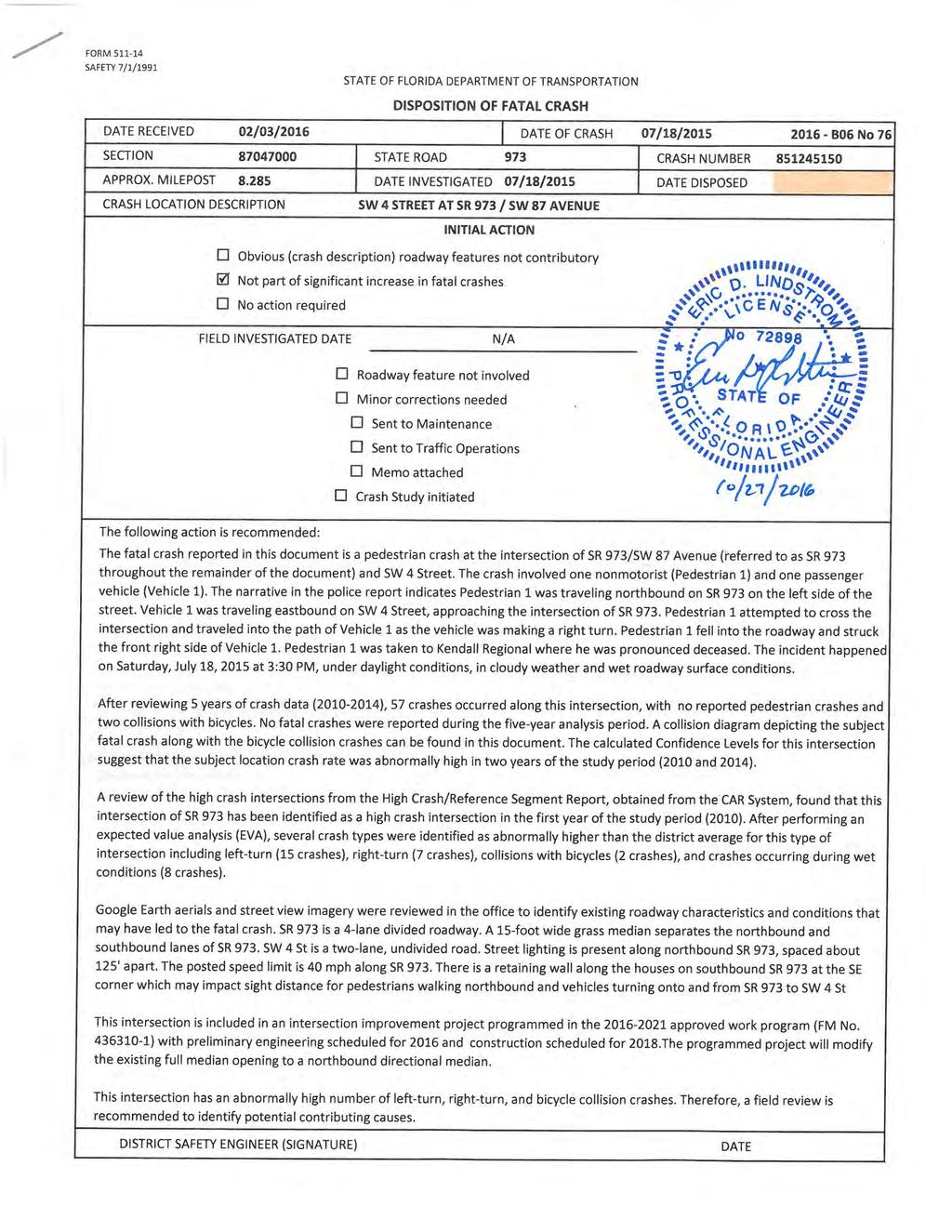
DISPOSITION OF FATAL CRASH
|
|
|
- Steven Lang
- 5 years ago
- Views:
Transcription
1
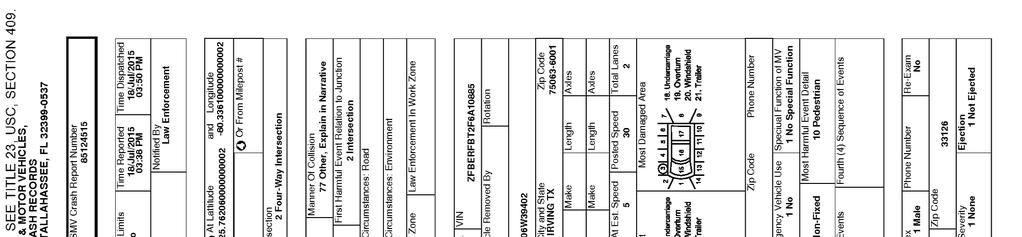
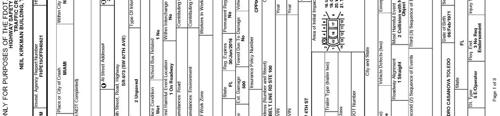
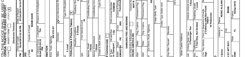
2 STATE OF FLORIDA DEPARTMENT OF TRANSPORTATION DISPOSITION OF FATAL CRASH DISTRICT SIX INITIAL REVIEW Relevant Studies/CTPs R Relevant Programmed Projects N/A FM No : SW 87 Avenue and SW 4 Street - Intersection Improvements R CRASH NARRATIVE The subject crash occurred in the unsignalized intersection of SW 4 Street and SR 973 within the city limits of Miami City in Miami- Dade County on Saturday, July 18, 2015 at 3:30 PM. According to the police report, Pedestrian 1 was traveling northbound on SR 973 on the left side of the street. Vehicle 1 was traveling eastbound on SW 4 Street, approaching the intersection of SR 973. Pedestrian 1 attempted to cross the intersection and traveled into the path of Vehicle 1 as the vehicle was making a right turn. Pedestrian 1 fell into the roadway and struck the front right side of Vehicle 1. The police report indicates that the incident happened under daylight conditions, in cloudy weather and wet roadway surface conditions. Pedestrian 1 was taken to Kendall Regional where he was pronounced deceased. R CRASH DATA REVIEW (crash summary sheets attached) The subject crash was a pedestrian crash. Five years of data ( ) was obtained at the intersection of SR 973 (MP to 8.335) and SW 4 Street from the FDOT Crash Analysis Reporting (CAR) System. A total of 57 crashes were reported at this intersection during the five-year study period: 20 crashes , 9 crashes, , 9 crashes , 4 crashes , and 15 crashes The trend was initially decreasing, but increased substantially in Out of the total number of crashes, 18 (31.6%) crashes occurred during nighttime conditions. The most common crash types at the study intersection are rear-end (16 crashes) and left-turn crashes (15 crashes). Out of the total number of crashes, 23 injury crashes, no fatal crashes, and 8 crashes occurred under wet roadway surface conditions. The crash data did not show any other pedestrian crashes; however, there were two bicycle collisions reported. The subject fatal crash and the two bicycle collisions are presented in the collision diagram. The calculated Confidence Levels for this intersection suggest that the subject location crash rate was abnormally high in two years of the study period (2010 and 2014). After performing an expected value analysis (EVA), several crash types were identified as abnormally higher than the district average for this type of intersection including left-turn (15 crashes), right-turn (7 crashes), collisions with bicycles (2 crashes), and crashes occurring during wet conditions (8 crashes). A review of the high crash intersections from the High Crash/Reference Intersections Report, obtained from the CAR System, found that the intersection of SR 973 and SW 4 Street has been identified as a high crash intersection during the first year of the study period (2010). R OFFICE-BASED REVIEW NOTES Google Earth aerials and street view imagery were reviewed in the office to identify existing roadway characteristics and conditions that may have led to the fatal crash. SR 973 is a 4-lane divided roadway. A 15-foot wide grass median separates the northbound and southbound lanes of SR 973. SW 4 Street is a two-lane, undivided road. Street lighting is present along northbound SR 973, spaced about feet apart. The posted speed limit is 40 mph along SR 973. There is a retaining wall adjacent to the houses on southbound SR 973 at the Southeast corner which may impact sight distance for both pedestrians walking northbound and vehicles turning onto and from SR 973 to SW 4 Street. The intersection is a two-way stop-controlled with visible crosswalks on the east and west legs of the intersection. There is one bus stop located on the southeast corner of the intersection and no bike lanes present. This intersection is included in an intersection improvement project programmed in the approved work program (FM No ) with preliminary engineering scheduled for 2016 and construction scheduled for The programmed project will modify the existing full median opening to a northbound directional median.

3 STATE OF FLORIDA DEPARTMENT OF TRANSPORTATION LOCATION MAP LOCATION ID SW 4 STREET AT SR 973 / SW 87 AVENUE COUNTY Miami-Dade SECTION BEGIN MILEPOST END MILEPOST PREPARED BY KAI Not to Scale CRASH SUMMARY (5 YEAR TOTALS) PDO INJURY CRASHES FATAL CRASHES TOTAL NIGHT CRASHES WET CRASHES
4

 Looking northbound along SR 973 in the vicinity the subject fatal crash location")
5 STATE OF FLORIDA DEPARTMENT OF TRANSPORTATION STREET VIEW IMAGERY LOCATION ID SW 4 STREET AT SR 973 / SW 87 AVENUE COUNTY Miami-Dade SECTION BEGIN MILEPOST END MILEPOST PREPARED BY KAI Looking eastbound along 4th Street at the subject fatal crash location (Photo Date: April 2015) Looking northbound along SR 973 in the vicinity the subject fatal crash location (Photo Date: May 2015)
 PDO INJURY CRASHES FATAL CRASHES TOTAL NIGHT CRASHES WET CRASHES 34 23 0 57 18 8 LEGEND Fatal")
6 COLLISION DIAGRAM LOCATION ID SW 4 STREET AT SR 973 / SW 87 AVENUE COUNTY Miami-Dade SECTION BEGIN MILEPOST END MILEPOST PREPARED BY KAI SR 973/SW 87th Ave Not to Scale 6 SW 4th Street 2 CRASH SUMMARY (5 YEAR TOTALS) PDO INJURY CRASHES FATAL CRASHES TOTAL NIGHT CRASHES WET CRASHES LEGEND Fatal Crash No. Crash No. XX Bicycle Crash Pedestrian Crash Dark Crash 2010 Crash 2011 Crash 2012 Crash 2013 Crash 2014 Crash Daylight Crash
7 SAFETY RATIO/CONFIDENCE LEVEL SUMMARY OF CRASHES BY CONTRIBUTING CAUSE Location: SW 4 STREET AT SR 973 / SW 87 AVENUE State Section: State Road: 973 Intersection: SW 4 STREET AT SR 973 / SW 87 AVENUE Engineer: KAI Area Type: Suburban Spot/Segment: Spot Spot Type: Begin Milepost: 4-5 Lanes 2wy Div Rasd 4 Legs End Milepost: Year Number of Crashes ADT Actual Crash Rate (ACR) , , , , , District 6 Average Crash Rate (A) Average Critical Crash Vehicle Rate (CCR) Exposure (M) Safety Ratio Statistical Significance Confidence Level % % % % % ADT Average Daily Traffic ACR Actual Crash Rate = No. of crashes in a year / Average Vehicle Exposure (M) M Average Vehicle Exposure (million vehicles or million vehicles miles) = [(ADT * 365 * L) / 1,000,000] L = Length of the Segment for Segment Analysis, 1 for Spot Analysis A Average Crash Rate CCR Critical Crash Rate = A + K * (SQRT[A/M]) - (1/[2 * M]) (Ref: FDOT Highway Safety Improvement Program Guidelines) K = for Urban, for Suburban, for Rural K = Safety Ratio = ACR/CCR Level of statistical significance = (ACR - A + (1/2M))/SQRT(A/M) Confidence Level = Percent probability that the crash rate is abnormally high for the location under study, using the district-wide average as a basis. Contributing Cause\Year Careless Driving Failed To Yield Right-Of-Way Improper Turn Disregarded Traffic Control (Signal/Stop) Improper Backing Improper Lane Change Followed Too Closely Alcohol/Drugs-Under Influence Failed To Maintain Equipment/Vehicle Improper Passing Exceed Safe/Stated Speed Limit Driving Wrong Side/Way/Drove Left of Center All Other Total Summary by Contributing Cause Year Total Crashes Mean Crashes Per Year Percent % % % % % % % % % % % % % % Note: The CARS summary provides two fields for contributing cause. To get a better understanding of the contributing causes in the crash analysis, the following assumptions are made to choose an appropriate contributing cause - If contributing cause 2 is 0 (unknown), 1 (no improper driving), 2 (careless driving), or 77 (all other), then contributing cause 1 is used. If contributing cause 1 is 2, then contributing cause 2 is used. If contributing cause 1 is 3 (failed to yield right-of-way) and contributing cause 2 is 11 (disregarded traffic signal), 13 (disregarded stop sign), 15 (improper passing), or 20 (disregarded other traffic control), then contributing cause 2 is used. 2014
8 FDOT DISTRICT 6 EXPECTED VALUES ANALYSIS SW 4 STREET AT SR 973 / SW 87 AVENUE 4 Lane x 2 Lane, Unsignalized, 4 Leg Intersection, Divided Number of Crashes Year Year Total Crashes Mean Crashes Per Year % Expected Annual Crash Value Abnormally High Crashes per year 90th percentile 95th percentile Abnormal 90th Percentile Abnormal 95th Percentile CRASH TYPE Rear End % Head On % Angle % Left Turn % X X Right Turn % X X Sideswipe % Backed Into % Coll. w/ Parked Car % Coll. w/ Pedestrian % Coll. w/ Bicycle % X X Fixed Object % Ran Off Road % Overturned % Other % Total Crashes % SEVERITY PDO Crashes % X Fatal Crashes % Injury Crashes % LIGHTING Daylight % CONDITIONS Dusk % Dawn % Dark % Unknown % SURFACE Dry % CONDITIONS Wet % X Others % MONTH January % X X OF YEAR February % March % April % May % June % X X July % August % X X September % October % November % December % DAY Sunday % OF WEEK Monday % X X Tuesday % X X Wednesday % X X Thursday % X Friday % Saturday % HOUR 00:00-06: % OF DAY 06:00-09: % X X 09:00-11: % X 11:00-13: % :00-15: % :00-18: % :00-24: % X Notes: 1) Collision with Bicycle Crashes include Collision with Bicycle/Collision with Bicycle in Bike Lane (Codes 11 and 12). 2) Fixed Object Crashes include collisions with sign/sign post, utility/light pole, guardrail, fence, concrete barrier wall, bridge, pier, abutment, rail, tree, shrubbery, construction barricade/sign, traffic gate, crash attenuators, other fixed objects (incl. above road). 3) Ran-off-Road Crashes include Ran in Ditch/Culvert and Ran off road into water (Codes 29 and 30). 4) Other crashes include crashes not categorized as the crash types shown in the table. 5) Dark Crashes include both scenarios - with and without street lighting.
9 FLORIDA DEPARTMENT OF TRANSPORTATION CRASH SUMMARY SECTION: STATE ROUTE: 973 INTERSECTING ROADWAY: SW 4 STREET AT SR 973 / SW 87 AVENUE M.P TO ENGINEER: KAI STUDY PERIOD: FROM 1/ 10 TO 12/ 10 COUNTY: Miami-Dade No. MILE POST DATE DAY TIME CRASH TYPE FATAL INJURY PROP DAM DAY / NIGHT WET / DRY CONTRIBUTING CAUSE /09/10 Tue 0900 Rear-End Day Dry Careless Driving /31/10 Wed 0500 Coll. W/ Bicycle Day Dry Careless Driving /02/10 Thu 0800 Sideswipe Day Dry Improper Lane Change /13/10 Wed 1300 Right-Turn Day Dry Improper Turn /25/10 Mon 1900 Rear-End Night Dry Careless Driving /10/10 Wed 1600 Left-Turn Day Dry Failed To Yield Right-Of-Way /22/10 Thu 2100 Backed Into Night Dry Improper Backing /25/10 Tue 2200 Rear-End Night Wet Careless Driving /04/10 Fri 0000 Right-Turn Night Dry Failed To Yield Right-Of-Way /22/10 Tue 1900 Angle Day Dry Failed To Yield Right-Of-Way /25/10 Fri 2000 Rear-End Night Dry Careless Driving /08/10 Thu 2100 Rear-End Night Dry Careless Driving /14/10 Wed 2200 All Other Night Dry Unknown/Not Coded /06/10 Fri 1900 Left-Turn Night Dry Failed To Yield Right-Of-Way /02/10 Thu 0800 Left-Turn Day Dry Failed To Yield Right-Of-Way /15/10 Wed 2000 Left-Turn Night Dry Failed To Yield Right-Of-Way /12/10 Sun 1100 Angle Day Dry Improper Turn /20/10 Mon 2000 Right-Turn Night Dry Improper Turn /28/10 Thu 1200 Rear-End Day Dry Followed Too Closely /20/10 Wed 0800 Rear-End Day Dry Careless Driving Total No. Fatal Injury PDO Angle Left Turn Right Turn Rear End Side swipe % 40.00% 60.00% 10.00% 20.00% 15.00% 35.00% 5.00% 5.00% One Vehicle Day Night Wet Dry Excess Speed FTYRW DUI % 50.00% 50.00% 5.00% 95.00% 0.00% 30.00% 0.00% TOTAL ENTERING VEHICLES/ADT: 41,500 SPOT CRASH RATE: Ped/ Bike
10 FLORIDA DEPARTMENT OF TRANSPORTATION CRASH SUMMARY SECTION: STATE ROUTE: 973 INTERSECTING ROADWAY: SW 4 STREET AT SR 973 / SW 87 AVENUE M.P TO ENGINEER: KAI STUDY PERIOD: FROM 1/ 11 TO 12/ 11 COUNTY: Miami-Dade No. MILE POST DATE DAY TIME CRASH TYPE FATAL INJURY PROP DAM DAY / NIGHT WET / DRY CONTRIBUTING CAUSE /04/11 Mon 1500 Sideswipe Day Dry Unknown/Not Coded /18/11 Fri 0200 Angle Night Wet #N/A /01/11 Tue 0700 Left-Turn Day Dry Careless Driving /12/11 Tue 2000 Angle Night Dry Improper Turn /01/11 Mon 2000 Rear-End Night Dry Disregarded Stop Sign /05/11 Tue 1900 Angle Night Dry Failed To Yield Right-Of-Way /01/11 Wed 0800 Right-Turn Day Dry Failed To Yield Right-Of-Way /28/11 Fri 1900 Left-Turn Night Dry Disregarded Stop Sign /16/11 Tue 1500 Rear-End Day Wet Careless Driving Total No. Fatal Injury PDO Angle Left Turn Right Turn Rear End Side swipe % 33.33% 66.67% 33.33% 22.22% 11.11% 22.22% 11.11% 0.00% One Vehicle Day Night Wet Dry Excess Speed FTYRW DUI % 44.44% 55.56% 22.22% 77.78% 0.00% 22.22% 0.00% TOTAL ENTERING VEHICLES/ADT: 36,000 SPOT CRASH RATE: Ped/ Bike
11 FLORIDA DEPARTMENT OF TRANSPORTATION CRASH SUMMARY SECTION: STATE ROUTE: 973 INTERSECTING ROADWAY: SW 4 STREET AT SR 973 / SW 87 AVENUE M.P TO ENGINEER: KAI STUDY PERIOD: FROM 1/ 12 TO 12/ 12 COUNTY: Miami-Dade No. MILE POST DATE DAY TIME CRASH TYPE FATAL INJURY PROP DAM DAY / NIGHT WET / DRY CONTRIBUTING CAUSE /03/12 Wed 1900 Occupant Fell From Veh Day Dry Unknown/Not Coded /28/12 Tue 1900 Rear-End Day Dry Careless Driving /13/12 Mon 0900 Left-Turn Day Dry Failed To Yield Right-Of-Way /24/12 Tue 1800 Right-Turn Night Dry Failed To Yield Right-Of-Way /16/12 Mon 1400 Left-Turn Day Dry Failed To Yield Right-Of-Way /21/12 Wed 0800 Left-Turn Day Dry Failed To Yield Right-Of-Way /06/12 Thu 0700 Left-Turn Day Dry No Improper Driving/Act /24/12 Sun 0700 Sideswipe Day Wet #N/A /06/12 Wed 1700 Rear-End Day Dry Careless Driving Total No. Fatal Injury PDO Angle Left Turn Right Turn Rear End Side swipe % 55.56% 44.44% 0.00% 44.44% 11.11% 22.22% 11.11% 0.00% One Vehicle Day Night Wet Dry Excess Speed FTYRW DUI % 88.89% 11.11% 11.11% 88.89% 0.00% 44.44% 0.00% TOTAL ENTERING VEHICLES/ADT: 42,000 SPOT CRASH RATE: Ped/ Bike
12 FLORIDA DEPARTMENT OF TRANSPORTATION CRASH SUMMARY SECTION: STATE ROUTE: 973 INTERSECTING ROADWAY: SW 4 STREET AT SR 973 / SW 87 AVENUE M.P TO ENGINEER: KAI STUDY PERIOD: FROM 1/ 13 TO 12/ 13 COUNTY: Miami-Dade No. MILE POST DATE DAY TIME CRASH TYPE FATAL INJURY PROP DAM DAY / NIGHT WET / DRY CONTRIBUTING CAUSE /07/13 Mon 0800 Rear-End Day Dry Careless Driving /15/13 Fri 0900 Angle Day Dry Failed To Yield Right-Of-Way /07/13 Thu 0900 Sideswipe Day Dry Improper Turn /13/13 Wed 1600 Sideswipe Day Wet Careless Driving Total No. Fatal Injury PDO Angle Left Turn Right Turn Rear End Side swipe % 25.00% 75.00% 25.00% 0.00% 0.00% 25.00% 50.00% 0.00% One Vehicle Day Night Wet Dry Excess Speed FTYRW DUI % % 0.00% 25.00% 75.00% 0.00% 25.00% 0.00% TOTAL ENTERING VEHICLES/ADT: 37,000 SPOT CRASH RATE: Ped/ Bike
13 FLORIDA DEPARTMENT OF TRANSPORTATION CRASH SUMMARY SECTION: STATE ROUTE: 973 INTERSECTING ROADWAY: SW 4 STREET AT SR 973 / SW 87 AVENUE M.P TO ENGINEER: KAI STUDY PERIOD: FROM 1/ 14 TO 12/ 14 COUNTY: Miami-Dade No. MILE POST DATE DAY TIME CRASH TYPE FATAL INJURY PROP DAM DAY / NIGHT WET / DRY CONTRIBUTING CAUSE /29/14 Tue 1600 Rear-End Day Dry Careless Driving /09/14 Fri 1000 Right-Turn Day Dry No Improper Driving/Act /07/14 Mon 0600 Left-Turn Day Dry No Improper Driving/Act /28/14 Fri 0800 Sideswipe Day Wet Failed To Yield Right-Of-Way /24/14 Thu 1800 Rear-End Day Dry Careless Driving /25/14 Thu 0900 Coll. W/ Bicycle Day Dry No Improper Driving/Act /25/14 Wed 0900 Angle Day Dry No Improper Driving/Act /21/14 Sat 2100 Head-On Night Wet Careless Driving /16/14 Thu 1300 Right-Turn Day Dry Failed To Yield Right-Of-Way /27/14 Wed 1300 Left-Turn Day Dry Failed To Yield Right-Of-Way /09/14 Tue 1200 Left-Turn Day Dry Failed To Yield Right-Of-Way /11/14 Tue 0700 Left-Turn Day Dry No Improper Driving/Act /18/14 Tue 1800 Left-Turn Night Dry Failed To Yield Right-Of-Way /20/14 Tue 1700 Rear-End Day Dry Careless Driving /03/14 Tue 0700 Rear-End Day Wet Careless Driving Total No. Fatal Injury PDO Angle Left Turn Right Turn Rear End Side swipe % 40.00% 60.00% 6.67% 33.33% 13.33% 26.67% 6.67% 6.67% One Vehicle Day Night Wet Dry Excess Speed FTYRW DUI % 86.67% 13.33% 20.00% 80.00% 0.00% 33.33% 0.00% TOTAL ENTERING VEHICLES/ADT: 34,000 SPOT CRASH RATE: Ped/ Bike
14


15
16
17 CCCCCCCCCC AAAAAAAAAA RRRRRRRRR CCCCCCCCCCC AAAAAAAAAAA RRRRRRRRRRR CCC AAA AAA RRR RRR CCC AAA AAA RRR RRR CCC AAAAAAAAAAA RRRRRRRRRRRR CCC AAAAAAAAAAA RRRRRRRRRRRR CCC AAA AAA RRR RRR CCC AAA AAA RRR RRR CCCCCCCCCCC AAA AAA RRR RRRR CCCCCCCCCCC AAA AAA RRR RRRRRR C R A S H R E P O R T I N G S Y S T E M N O T I C E: THE INFORMATION CONTAINED IN THIS DOCUMENT (REPORT, SCHEDULE, LIST, OR DATA) HAS BEEN COMPILED FROM INFORMATION COLLECTED FOR THE PURPOSE OF IDENTIFYING, EVALUATING, OR PLANNING SAFETY ENHANCEMENTS. THIS PRODUCT IDENTIFIES INFORMATION USED FOR THE PURPOSE OF DEVELOPING HIGHWAY SAFETY CONSTRUCTION IMPROVEMENT PROJECTS WHICH MAY BE IMPLEMENTED UTILIZING FEDERAL-AID HIGHWAY FUNDS. ANY DOCUMENT DISPLAYING THIS NOTICE SHALL BE USED ONLY FOR THOSE PURPOSES DEEMED APPROPRIATE BY THE FLORIDA DEPARTMENT OF TRANSPORTATION. SEE TITLE 23, UNITED STATES CODE, SECTION 409. I/O NAME:... CARI113 PROGRAM ID:... CARPJ13 REPORT NUMBER: RUN CLASS:... A MESSAGE CLASS:... Q PRINTER DEST:... LOCAL # COPIES: ACCOUNT #: SUBMIT W/HOLD?... N USERID:... KNKAIBP DETAIL SORT ORDER: SORT BY ROADWAY, MILE POINT PRINT SEGMENTS?... N PRINT INTERSECTIONS?... N SUMMARY FORMAT:... - OVERRIDE VALUES: MAX # OF BREAKS:... 0 CRASH RATE CATEGORY:... AVERAGE DAILY TRAFFIC:.. # OF LEGS:...
18 REPORT...CARPJ13-01 FLORIDA - DEPARTMENT OF TRANSPORTATION PAGE NO: 1 DATE...05/31/2016 C A R - CRASH ANALYSIS REPORTING SYSTEM USERID: KNKAIBP TIME...15:46:54 CRASH DATA DETAIL AND EXTRACT FOR STATE-MAINTAINED ROADS I/O... CARO213 COMMENT: 1 - SORT BY ROADWAY, MILE POINT FROM: 01/01/2010 TO 12/31/2010 RAMPS INCL FROM CO/SEC/SUB: MP: INFL INCL TO CO/SEC/SUB: MP: CR/OS INCL C ROADWYID M N S ADT Y M D H CRCC A H L W R T R SL R A V V VM V PI CC D V V V V PI CC D # # N R N C S S I EN TR VAR E O A O RALA L AE I E D RC OC IO O C ET EU EO E OM OA RA ET EU EM E OM OA RA UI A U O E E L AO AO EIA A N Y U ATAT C RV G A AO AO TC A C HY HS HV H IP NU IG HY HS HO H IP NU IG V K MN S M U C SC E RD TA RLF R T R SESE ME H T S FN DN EA D IP IE IM NA TS VE IP IE IV NA TS VE E I BJ H B N T UT P EE ED AYF H H SG I FN T H U FT D T L CE C CN D TC RE / CE C C D TC RE / H L EU E T I BI O S G I O N UT I E R IR T I S N L L1 LT I T I P1 L L2 L2 I T I P2 C L RR R Y O O S T E C R V L N R F CO N O D E1 E E R O B1 E E2 E E R O B2 E L E E N N T Y 1 G L S N # 1 1 F1 D 2 F2 D S D D ************************************************************************************************************************************ U-4DR R N N U-4DR R N N U-4DR R N N U-4DR L S S U-4DR T E E U-4DR R W N U-4DR S W W U-4DR T S S U-4DR L E S U-4DR R W N U-4DR R N N U-4DR T S S U-4DR R W N U-4DR L E S U-4DR R E N U-4DR R W N U-4DR T W E U-4DR T W E U-4DR L S S U-4DR R N N
19 REPORT...CARPJ13-01 FLORIDA - DEPARTMENT OF TRANSPORTATION PAGE NO: 2 DATE...05/31/2016 C A R - CRASH ANALYSIS REPORTING SYSTEM USERID: KNKAIBP TIME...15:46:54 CRASH DATA DETAIL AND EXTRACT FOR STATE-MAINTAINED ROADS I/O... CARI113 COMMENT: 1 - SORT BY ROADWAY, MILE POINT FROM: 01/01/2010 TO 12/31/2010 RAMPS INCL FROM CO/SEC/SUB: MP: INFL INCL TO CO/SEC/SUB: MP: CR/OS INCL INFLUENCE CRASHES PROPERTY OCCURRING ON FATAL CRASH STATISTICS INJURY CRASH STATS DAMAGE ONLY TOTALS INTERSECTING RDWYS FOR YEAR CRASHES FATALITIES INJURIES CRASHES INJURIES CRASHES CRASHES FATALITIES INJURIES AT INT. INFL AREA TOTAL N O T I C E: THE INFORMATION CONTAINED IN THIS DOCUMENT (REPORT, SCHEDULE, LIST, OR DATA) HAS BEEN COMPILED FROM INFORMATION COLLECTED FOR THE PURPOSE OF IDENTIFYING, EVALUATING, OR PLANNING SAFETY ENHANCEMENTS. THIS PRODUCT IDENTIFIES INFORMATION USED FOR THE PURPOSE OF DEVELOPING HIGHWAY SAFETY CONSTRUCTION IMPROVEMENT PROJECTS WHICH MAY BE IMPLEMENTED UTILIZING FEDERAL-AID HIGHWAY FUNDS. ANY DOCUMENT DISPLAYING THIS NOTICE SHALL BE USED ONLY FOR THOSE PURPOSES DEEMED APPROPRIATE BY THE FLORIDA DEPARTMENT OF TRANSPORTATION. SEE TITLE 23, UNITED STATES CODE, SECTION 409.
20 CCCCCCCCCC AAAAAAAAAA RRRRRRRRR CCCCCCCCCCC AAAAAAAAAAA RRRRRRRRRRR CCC AAA AAA RRR RRR CCC AAA AAA RRR RRR CCC AAAAAAAAAAA RRRRRRRRRRRR CCC AAAAAAAAAAA RRRRRRRRRRRR CCC AAA AAA RRR RRR CCC AAA AAA RRR RRR CCCCCCCCCCC AAA AAA RRR RRRR CCCCCCCCCCC AAA AAA RRR RRRRRR C R A S H R E P O R T I N G S Y S T E M N O T I C E: THE INFORMATION CONTAINED IN THIS DOCUMENT (REPORT, SCHEDULE, LIST, OR DATA) HAS BEEN COMPILED FROM INFORMATION COLLECTED FOR THE PURPOSE OF IDENTIFYING, EVALUATING, OR PLANNING SAFETY ENHANCEMENTS. THIS PRODUCT IDENTIFIES INFORMATION USED FOR THE PURPOSE OF DEVELOPING HIGHWAY SAFETY CONSTRUCTION IMPROVEMENT PROJECTS WHICH MAY BE IMPLEMENTED UTILIZING FEDERAL-AID HIGHWAY FUNDS. ANY DOCUMENT DISPLAYING THIS NOTICE SHALL BE USED ONLY FOR THOSE PURPOSES DEEMED APPROPRIATE BY THE FLORIDA DEPARTMENT OF TRANSPORTATION. SEE TITLE 23, UNITED STATES CODE, SECTION 409. I/O NAME:... CARI122 PROGRAM ID:... CARPJ122 REPORT NUMBER: RUN CLASS:... A MESSAGE CLASS:... Q PRINTER DEST:... LOCAL # COPIES: ACCOUNT #: SUBMIT W/HOLD?... N USERID:... KNKAIBP DETAIL SORT ORDER: SORT BY ROADWAY, MILE POINT PRINT SEGMENTS?... N PRINT INTERSECTIONS?... N SUMMARY FORMAT: TOP LINE ALL BREAKS OVERRIDE VALUES: MAX # OF BREAKS: CRASH RATE CATEGORY:... AVERAGE DAILY TRAFFIC:.. # OF LEGS:...
21 REPORT...CARPJ FLORIDA - DEPARTMENT OF TRANSPORTATION PAGE NO: 1 DATE...10/26/2016 C A R - CRASH ANALYSIS REPORTING SYSTEM USERID: KNKAIBP TIME...19:31:53 CRASH DATA (IN 2011 AND LATER) DETAIL FOR STATE-MAINTAINED ROADS I/O... CARO213 COMMENT: 1 - SORT BY ROADWAY, MILE POINT FROM: 01/01/2011 TO 12/31/2014 RAMPS INCL FROM CO/SEC/SUB: MP: INFL INCL TO CO/SEC/SUB: MP: CR/OS INCL C ROADWYID M N S ADT Y M D H CRCC A H MO L W R R DL R A V V VF VM VA V V V V VN VN N V # # # R N C S S I EN TR VAR E O A O RALA L AE AF IC EC D OC OO O C 1 1 1U 1A 1C 1A 2 2N 2N 2M 2M M 2N A U O E E L AO AO EIA A N Y U ATAT C RV N GO AO AO TC A C N N T G M M M V K I S M U C SC E RD TA RLF R T R SESE ME NC HN TN S DN A D D B SC E DI DE D B F MP AA A D E I N H B N T UT P EE ED AYF H H SG I FN EO TD HD U D ST L I OT P U RO R I OD UL NR CC C RA H L J E T I BI O S G I O N UT RL IT ET R T II S N R DY E V IN I R DE NO VI TT T AG C L U R Y O O S T E C R V L L NN RN F N TO D YP C E V V /S CC RO 1N N GE L E R N N T Y 1 GS S S EN # E R R1 R C / /R /1 2 E S D D *********************************************************************************************************************************** U-4DR L 1 S S U-4DR R 2 N N U-4DR L 1 S W U-4DR L 1 S S U-4DR L 2 S U-4DR R 1 E N U-4DR L 2 E S U-4DR R 2 W N U-4DR T 1 S E U-4DR L 2 E S U-4DR R 1 E N U-4DR R 2 W N U-4DR R 1 W N U-4DR R 2 W N U-4DR R 1 W E U-4DR L 1 E S Y U-4DR T S E E U-4DR L 3 W S U-4DR L 1 S S U-4DR R 1 W N U-4DR L 2 E S U-4DR L 1 W S U-4DR R 1 E N U-4DR L 3 S S U-4DR R 2 W E U-4DR T 1 S E U-4DR R 2 E N U-4DR R 1 E N U-4DR R 1 E N U-4DR S C E * U-4DR L 2 E S U-4DR I M W E U-4DR L 1 E S U-4DR R 1 N N U-4DR L 2 S S U-4DR R 2 N N U-4DR L 1 S S
22 REPORT...CARPJ FLORIDA - DEPARTMENT OF TRANSPORTATION PAGE NO: 2 DATE...10/26/2016 C A R - CRASH ANALYSIS REPORTING SYSTEM USERID: KNKAIBP TIME...19:31:53 CRASH DATA (IN 2011 AND LATER) DETAIL FOR STATE-MAINTAINED ROADS I/O... CARI122 COMMENT: 1 - SORT BY ROADWAY, MILE POINT FROM: 01/01/2011 TO 12/31/2014 RAMPS INCL FROM CO/SEC/SUB: MP: INFL INCL TO CO/SEC/SUB: MP: CR/OS INCL INFLUENCE CRASHES PROPERTY OCCURRING ON FATAL CRASH STATISTICS INJURY CRASH STATS DAMAGE ONLY TOTALS INTERSECTING RDWYS FOR YEAR CRASHES FATALITIES INJURIES CRASHES INJURIES CRASHES CRASHES FATALITIES INJURIES AT INT. INFL AREA TOTAL N O T I C E: THE INFORMATION CONTAINED IN THIS DOCUMENT (REPORT, SCHEDULE, LIST, OR DATA) HAS BEEN COMPILED FROM INFORMATION COLLECTED FOR THE PURPOSE OF IDENTIFYING, EVALUATING, OR PLANNING SAFETY ENHANCEMENTS. THIS PRODUCT IDENTIFIES INFORMATION USED FOR THE PURPOSE OF DEVELOPING HIGHWAY SAFETY CONSTRUCTION IMPROVEMENT PROJECTS WHICH MAY BE IMPLEMENTED UTILIZING FEDERAL-AID HIGHWAY FUNDS. ANY DOCUMENT DISPLAYING THIS NOTICE SHALL BE USED ONLY FOR THOSE PURPOSES DEEMED APPROPRIATE BY THE FLORIDA DEPARTMENT OF TRANSPORTATION. SEE TITLE 23, UNITED STATES CODE, SECTION 409.
DISPOSITION OF FATAL CRASH
 FORM 511-14 SAFETY 7/1/1991 DATE RECEIVED SECTION APPROX. MILEPOST CRASH LOCATION DESCRIPTION STATE OF FLORIDA DEPARTMENT OF TRANSPORTATION DISPOSITION OF FATAL CRASH 06/12/2013 DATE OF CRASH 02/23/2013
Annual Collision Report
 2016 Annual Collision Report Contents The Annual Collision Report is a summary of statistics associated with traffic collisions that occurred in the City of Winnipeg. This information is provided by Manitoba
collision analyses...
 collision analyses. 28 INJURY SUMMARY YEAR COLLISION NON-INJURY INJURY FATAL TOTAL TOTAL PERCENT TOTAL PERCENT TOTAL PERCENT 2004 7410 5124 69.15% 2259 30.49% 27 0.36% 2005 6767 4538 67.06% 2214 32.72%
HSIP FUNDING APPLICATION
 Page 1 Lucas County - Sylvania Ave at Centennial Rd DATE 5/1/2013 Project Information: COUNTY Lucas County LOCATION TYPE PROJECT SERVICE LIFE 20 years SEGMENT INFORMATION ROUTE BEGIN SLM END SLM PRESENT
WEBER ROAD RESIDENTIAL DEVELOPMENT Single Family Residential Project
 WEBER ROAD RESIDENTIAL DEVELOPMENT Single Family Residential Project WEBER ROAD RESIDENTIAL DEVELOPMENT TRAFFIC IMPACT STUDY TABLE OF CONTENTS 1.0 Executive Summary Page 2.0 Introduction 2.1 DEVELOPMENT
Case Histories and Practical Examples
 SUMMER SCHOOL SIIV 2012 - ROAD SAFETY MANAGEMENT Theoretical principles and practical application in the framework of the European Directive 2008/96/CE Catania 24-28 September 2012 Case Histories and Practical
Monroe County: Key West and Lower Keys
 FDOT PROJECT UPDATES June 15-21, 2015 Monroe County: Key West and Lower Keys Monroe County projects website: www.fdotmonroe.com Opt Out: If you no longer wish to receive these weekly notifications, please
Montmorency County Traffic Crash Data & Year Trends. Reporting Criteria
 June 2018 Revised 8/3/2018 2017 Reporting Criteria Please pay particular attention to the wording when interpreting the three levels of data gathered for this report. Crash The Crash Level analyzes data
Montmorency County Traffic Crash Data & Year Trends. Reporting Criteria
 June 2017 Revised 10/3/17 2016 Reporting Criteria Please pay particular attention to the wording when interpreting the three levels of data gathered for this report. Crash The Crash Level analyzes data
VIRGINIA S I-77 VARIABLE SPEED LIMIT SYSTEM FOR LOW VISIBILITY CONDITIONS
 VIRGINIA S I-77 VARIABLE SPEED LIMIT SYSTEM FOR LOW VISIBILITY CONDITIONS Christopher D. McDonald, PE, PTOE Regional Operations Director, Southwest Region NRITS and ITS Arizona Annual Conference October
HSIP FUNDING APPLICATION
 Page 1 Holmes County County Road 52; 1.19 to 5.48 DATE 5/1/2013 Project Information: COUNTY Holmes County LOCATION TYPE PROJECT SERVICE LIFE 20 years SEGMENT INFORMATION ROUTE County Road 52 BEGIN SLM
The Sunland Park flyover ramp is set to close the week of March 19 until early summer
 March 2, 2018 The Sunland Park flyover ramp is set to close the week of March 19 until early summer GO 10 is targeting the week of March 19 to close the Sunland Park Drive flyover entrance ramp to I 10
TRAFFIC IMPACT STUDY. Platte Canyon Villas Arapahoe County, Colorado (Arapahoe County Case Number: Z16-001) For
 For") TRAFFIC IMPACT STUDY For Platte Canyon Villas Arapahoe County, Colorado (Arapahoe County Case Number: Z16-001) February 2015 Revised: August 2015 April 2016 July 2016 September 2016 Prepared for: KB Home
TRAFFIC IMPACT STUDY For Platte Canyon Villas Arapahoe County, Colorado (Arapahoe County Case Number: Z16-001) February 2015 Revised: August 2015 April 2016 July 2016 September 2016 Prepared for: KB Home
TRAFFIC ALERT FOR WEEK OF February 4 8, 2008
 TRAFFIC ALERT FOR WEEK OF February 4 8, 2008 Highway work zones in the Staunton District The following is a list of highway work that might affect traffic in the Staunton transportation district during
Factors Affecting the Severity of Injuries Sustained in Collisions with Roadside Objects
 Factors Affecting the Severity of Injuries Sustained in Collisions with Roadside Objects Presenter: Ashirwad Barnwal Adviser: Dr. Peter T. Savolainen Source: clipartbest.com 1 Overview Background Research
MEMORANDUM. The study area of the analysis was discussed with City staff and includes the following intersections:
 MEMORANDUM DATE: JULY 6, 2012 TO: FROM: RE: CC: MELANIE KNIGHT BRAD BYVELDS/ JENNIFER LUONG 1050 SOMERSET STREET PRELIMINARY TRAFFIC ANALYSIS OUR FILE NO. 111152 NEIL MALHOTRA The purpose of this memo
Speed Limit Review. Montague Road, West End. Prepared for Brisbane City Council CEB06842 CEB06842
 Speed Limit Review Montague Road, West End CEB06842 CEB06842 Prepared for Brisbane City Council 2 November 2016 Speed Limit Review Montague Road, West End Document Information Prepared for Brisbane City
JEP John E. Jack Pflum, P.E. Consulting Engineering 7541 Hosbrook Road, Cincinnati, OH Telephone:
 JEP John E. Jack Pflum, P.E. Consulting Engineering 7541 Hosbrook Road, Cincinnati, OH 45243 Email: jackpflum1@gmail.com Telephone: 513.919.7814 MEMORANDUM REPORT Traffic Impact Analysis Proposed Soccer
Brandywine Road Speed Study FINAL REPORT
 Brandywine Road Speed Study FINAL REPORT City of Albuquerque Brandywine Road Speed Study Final Report Albuquerque, New Mexico City of Albuquerque May, 2016 Brandywine Road Speed Study Final Report City
EXAMINATION OF THE SAFETY IMPACTS OF VARYING FOG DENSITIES: A CASE STUDY OF I-77 IN VIRGINIA
 0 0 0 EXAMINATION OF THE SAFETY IMPACTS OF VARYING FOG DENSITIES: A CASE STUDY OF I- IN VIRGINIA Katie McCann Graduate Research Assistant University of Virginia 0 Edgemont Road Charlottesville, VA 0 --
The Highline Development Traffic Impact Study
 The Highline Development Traffic Impact Study Columbia Falls, Montana Prepared For: TD&H Engineering 450 Corporate Drive, Suite 101 Kalispell, MT 59901 June, 2018 130 South Howie Street Helena, Montana
Focused Traffic Analysis for the One Lincoln Park Project
 September 15, 2015 Mr. Bill Johnson Coldwell Banker 511 Sir Francis Drake Boulevard Greenbrae, CA 94904 Focused Traffic Analysis for the One Lincoln Park Project Dear Mr. Johnson; As requested, W-Trans
Market Street PDP. Nassau County, Florida. Transportation Impact Analysis. VHB/Vanasse Hangen Brustlin, Inc. Nassau County Growth Management
 Transportation Impact Analysis Market Street PDP Nassau County, Florida Submitted to Nassau County Growth Management Prepared for TerraPointe Services, Inc. Prepared by VHB/Vanasse Hangen Brustlin, Inc.
I-10 East at Redd closes for 24 hours this Sunday, Feb 11. Then, I-10 West at Resler closes for 27 hours on Feb 25
 NEWS RELEASE a TxDOT Project For immediate release EL PASO DISTRICT Jennifer Wright (915) 790-4340 Jennifer.Wright3@txdot.gov February 9, 2018 I-10 East at Redd closes for 24 hours this Sunday, Feb 11
ROAD SAFETY AUDIT. VFW Parkway at Spring Street at Bridge Street (Route 109) City of Boston. November 13, Prepared For: MassDOT Highway Division
 City of Boston. November 13, Prepared For: MassDOT Highway Division") ROAD SAFETY AUDIT VFW Parkway at Spring Street at Bridge Street (Route 109) City of Boston November 13, 2015 Prepared For: MassDOT Highway Division Prepared By: Nitsch Engineering 2 Center Plaza, Suite
ROAD SAFETY AUDIT VFW Parkway at Spring Street at Bridge Street (Route 109) City of Boston November 13, 2015 Prepared For: MassDOT Highway Division Prepared By: Nitsch Engineering 2 Center Plaza, Suite
HALFF 16196? TRAFFIC MANAGEMENT PLAN. Richardson ISD Aikin Elementary School Dallas, Texas North Bowser Road Richardson, Texas 75081
 30280 16196? TRAFFIC MANAGEMENT PLAN Exhibit 572B Aikin Elementary School Planned Development District No. 572 Approved City Plan Commission October20, 2016 July 12, 2016 Prepared for HALFF AVO 31586 PHO1
AASHTO Committee on Maintenance 2018 Annual Meeting July 25, Hurricane Irma- Preparation and Response
 AASHTO Committee on Maintenance 2018 Annual Meeting July 25, 2018 Hurricane Irma- Preparation and Response Rudy Powell Director, Office of Maintenance Satellite Aerial Image (September 10, 2017) Hurricane
Parking Study MAIN ST
 Parking Study This parking study was initiated to help understand parking supply and parking demand within Oneida City Center. The parking study was performed and analyzed by the Madison County Planning
April 10, Mr. Curt Van De Walle, City Manager City of Castle Hills 209 Lemonwood Drive Castle Hills, Texas 78213
 Mr. Curt Van De Walle, City Manager City of Castle Hills 209 Lemonwood Drive Castle Hills, Texas 78213 Subject: Revised Castle Hills BASIS Charter School Traffic Impact Analysis Review City of Castle Hills,
EVALUATION OF SAFETY PERFORMANCES ON FREEWAY DIVERGE AREA AND FREEWAY EXIT RAMPS. Transportation Seminar February 16 th, 2009
 EVALUATION OF SAFETY PERFORMANCES ON FREEWAY DIVERGE AREA AND FREEWAY EXIT RAMPS Transportation Seminar February 16 th, 2009 By: Hongyun Chen Graduate Research Assistant 1 Outline Introduction Problem
Bike Week Crash Analysis
 Bike Week Crash Analysis David Salzer Patrick Santoso University of New Hampshire 7/15/2014 1 What is Bike Week? Official name is Laconia Motorcycle Week First or second week of June 2013 attendance: 330,000
Subject: Desert Palisades Specific Plan - Tram Way Access Sight Distance
 Endo Engineering Traffic Engineering Air Quality Studies Noise Assessments July 13, 2015 Mr. Ed Freeman Pinnacle View, LLC P.O. Box 1754 Lake Oswego, OR 97035-0579 Subject: Desert Palisades Specific Plan
CITY OF MINOT SNOW REMOVAL PLAN October 2018
 CITY OF MINOT SNOW REMOVAL PLAN October 2018 1.0 GENERAL This plan has been written to provide information regarding snow removal procedures and policies. The plan provides guidance, while maintaining
1.0 INTRODUCTION AND SUMMARY...
 TABLE OF CONTENTS 1.0 INTRODUCTION AND SUMMARY... 1 1.1 Purpose and Study Objective... 1 1.2 Executive Summary... 1 2.0 ROADWAY CONDITIONS... 5 2.1 Granville Parkway (South Intersection)... 8 2.2 Tuscany
Traffic Impact Study
 Traffic Impact Study Statham DRI One University Parkway Prepared for: Barrow County Prepared by: October 2012 Table of Contents Executive Summary i Section 1. Introduction 1 Project Description 1 Methodology
A Study of Red Light Cameras in Kansas City, MO
 A Study of Red Light s in Kansas City, MO Prepared by the Special Operations Division Executive Summary This paper will analyze the crash data for the 29 red light cameras located in 17 intersections in
West Tennessee Construction June 14-21, 2017
 FOR IMMEDIATE RELEASE Wednesday, June 14, 2017 CONTACT: Nichole Lawrence CELL: 731-225-6041 West Tennessee Construction June 14-21, 2017 BENTON COUNTY, I-40 Truck Climbing Lane Wednesday, June 7 through
Implication of GIS Technology in Accident Research in Bangladesh
 Journal of Bangladesh Institute of Planners ISSN 2075-9363 Vol. 8, 2015 (Printed in December 2016), pp. 159-166, Bangladesh Institute of Planners Implication of GIS Technology in Accident Research in Bangladesh
Active Traffic & Safety Management System for Interstate 77 in Virginia. Chris McDonald, PE VDOT Southwest Regional Operations Director
 Active Traffic & Safety Management System for Interstate 77 in Virginia Chris McDonald, PE VDOT Southwest Regional Operations Director Interstate 77 at Fancy Gap Mountain Mile markers 0-15 Built in late
FDOT Level 2 Roundabout b/c Evaluation
 FDOT Level 2 Roundabout b/c Evaluation This spreadsheet tool compares the cost of a roundabout to the cost of a traditional intersection, as specified by the user. A traditional intersection is defined
NATHAN HALE HIGH SCHOOL PARKING AND TRAFFIC ANALYSIS. Table of Contents
 Parking and Traffic Analysis Seattle, WA Prepared for: URS Corporation 1501 4th Avenue, Suite 1400 Seattle, WA 98101-1616 Prepared by: Mirai Transportation Planning & Engineering 11410 NE 122nd Way, Suite
Effectiveness of Experimental Transverse- Bar Pavement Marking as Speed-Reduction Treatment on Freeway Curves
 Effectiveness of Experimental Transverse- Bar Pavement Marking as Speed-Reduction Treatment on Freeway Curves Timothy J. Gates, Xiao Qin, and David A. Noyce Researchers performed a before-and-after analysis
Submittal/Approval Letter
 Submittal/Approval Letter To: Patrick Muench, P.E. Date: May 1, 2017 Turnpike Design Engineer Financial Project ID: 436517-1-52-01 & 436517-3-52-01 New Construction ( ) RRR ( ) Federal Aid : Not Applicable
Mountain View Community Shuttle Monthly Operations Report
 Mountain View Community Shuttle Monthly Operations Report October 9, 2018 Contents Passengers per Day, Table...- 3 - Passengers per Day, Chart...- 3 - Ridership Year-To-Date...- 4 - Average Daily Ridership
Appendix C Traffic Study
 Final Environmental Impact Statement Appendix C Traffic Study Schofield Generating Station Project, Hawaii October 2015 C-1 Final Environmental Impact Statement This page intentionally left blank. Schofield
Local Calibration Factors for Implementing the Highway Safety Manual in Maine
 Local Calibration Factors for Implementing the Highway Safety Manual in Maine 2017 Northeast Transportation Safety Conference Cromwell, Connecticut October 24-25, 2017 MAINE Darryl Belz, P.E. Maine Department
I-95/I-85 INTERCHANGE ROADWAY SAFETY ASSESSMENT
 FINAL REPORT I-95/I-85 INTERCHANGE ROADWAY SAFETY ASSESSMENT Prepared for: Prepared by: 117306012.B MARCH 2013 Final Report March 2013 I-95/I-85 Interchange ROADWAY SAFETY ASSESSMENT Prepared for: Prepared
MADISON, WI STONE HOUSE DEVELOPMENT 1000 E. WASHINGTON AVENUE REDEVELOPMENT TRANSPORTATION STUDY DECEMBER 14, 2015
 MADISON, WI STONE HOUSE DEVELOPMENT 1000 E. WASHINGTON AVENUE REDEVELOPMENT TRANSPORTATION STUDY DECEMBER 14, 2015 TABLE OF CONTENTS... 3 Proposed Development... 3 Methodology... 3 Phase 1 Development...
CVS Derwood. Local Area Transportation Review
 CVS Derwood Montgomery County, Maryland May 27, 2016 Local Area Transportation Review Prepared for: JC Bar Properties, Inc. Steve Fleming, PE 415 Fallowfield Road, Suite 301 Camp Hill, Pennsylvania 17011
ROAD INVENTORY FOR CERTIFICATION OF MILEAGE
 ROD INVENTORY FOR CERTIFICTION OF MILEGE Kay F outs Road Inventory Supervisor, IS H C ISHC ROD IN V E N T O R Y SECTIO N ND DT C O L L E C T IO N s provided in the Indiana Code, the Indiana State Highway
FINAL REPORT. City of Toronto. Contract Project No: B
 City of Toronto SAFETY IMPACTS AND REGULATIONS OF ELECTRONIC STATIC ROADSIDE ADVERTISING SIGNS TECHNICAL MEMORANDUM #2B BEFORE/AFTER COLLISION ANALYSIS AT MID-BLOCK LOCATIONS FINAL REPORT 3027 Harvester
CITY OF MINOT SNOW REMOVAL PLAN November 2017
 CITY OF MINOT SNOW REMOVAL PLAN November 2017 1.0 GENERAL This plan has been written to provide information regarding snow removal procedures and policies. The plan provides guidance, while maintaining
Table of Contents Introduction... 4 Study Area... 5
 Table of Contents Introduction... 4 Study Area... 5 Streets and s... 5 Traffic Volumes... 8 Recent and Anticipated Development... 10 Crash Analysis... 10 Projected Traffic Volumes... 11 Trip Generation...
Critchfield Rd / SR-129
 NOVEMBER 27, 2017 Critchfield Rd / SR-129 Intersection Safety Study Alternatives Report CRITCHFIELD INTERSECTION SAFETY STUDY Contents Introduction...1 Purpose...2 Existing Conditions...2 Proposed Alternatives...2
Appendix C Final Methods and Assumptions for Forecasting Traffic Volumes
 Fairview Ave. and Main St. Improvements and Local Streets Plan Appendices Ada County Highway District Appendix C Final Methods and Assumptions for Forecasting Traffic Volumes January 3, 207 Appendices
Mountain View Community Shuttle Monthly Operations Report
 Mountain View Community Shuttle Monthly Operations Report December 6, 2018 Contents Passengers per Day, Table...- 3 - Passengers per Day, Chart...- 3 - Ridership Year-To-Date...- 4 - Average Daily Ridership
Perth County Road Fatal Head-on Collision - A Common and Dangerous Issue
 Perth County Road Fatal Head-on Collision - A Common and Dangerous Issue Posting Date: 25-Aug-2016 Figure 1: View looking east long "Speeders Alley" - a more appropriate name for the long, straight and
OREGON DEPARTMENT OF TRANSPORTATION STATEWIDE ROAD, WEATHER AND INCIDENT CONDITIONS 4/22/2019 4:20:05 AM
 OREGON DEPARTMENT OF TRANSPORTATION STATEWIDE ROAD, WEATHER AND INCIDENT CONDITIONS Incidents/: 4/22/2019 4:20:05 AM HWY372 22 22 Mount Bachelor Ski Area I-5 10 13 5 Mi S of Ashland Informational only
SYSTEMATIC EVALUATION OF RUN OFF ROAD CRASH LOCATIONS IN WISCONSIN FINAL REPORT
 SYSTEMATIC EVALUATION OF RUN OFF ROAD CRASH LOCATIONS IN WISCONSIN FINAL REPORT DECEMBER 2004 DISCLAIMER This research was funded by the Wisconsin Department of Transportation. The contents of this report
IOWA COUNTY ORDINANCE NO. 22 IOWA COUNTY SNOW & ICE POLICY
 IOWA COUNTY ORDINANCE NO. 22 IOWA COUNTY SNOW & ICE POLICY AN ORDINANCE REPEALING ESTABLISHING THE POLICY AND LEVEL OF SERVICE IN RESPECT TO CLEARANCE OF SNOW AND ICE AND MAINTENANCE OF IOWA COUNTY S SECONDARY
TRAFFIC IMPACT STUDY
 TRAFFIC IMPACT STUDY TERRE HAUTE CONVENTION CENTER WABASH AVENUE & 9 TH STREET TERRE HAUTE, INDIANA PREPARED FOR 8365 Keystone Crossing, Suite 201 Indianapolis, IN 46240 Phone: (317) 202-0864 Fax: (317)
CITY OF MINOT SNOW REMOVAL PLAN JANUARY 2015
 CITY OF MINOT SNOW REMOVAL PLAN JANUARY 2015 1.0 GENERAL This plan has been written to provide information regarding snow removal procedures and policies. The plan provides guidance, while maintaining
Welcome to the Public Meeting Red Bluff Road from Kirby Boulevard to State Highway 146 Harris County, Texas CSJ No.: December 15, 2016
 Welcome to the Public Meeting Red Bluff Road from Kirby Boulevard to State Highway 146 Harris County, Texas CSJ No.: 0912-72-340 December 15, 2016 No formal presentation will be made. Seabrook Intermediate
Appendix BAL Baltimore, Maryland 2003 Annual Report on Freeway Mobility and Reliability
 (http://mobility.tamu.edu/mmp) Office of Operations, Federal Highway Administration Appendix BAL Baltimore, Maryland 2003 Annual Report on Freeway Mobility and Reliability This report is a supplement to:
Trip Generation Study: A 7-Eleven Gas Station with a Convenience Store Land Use Code: 945
 Trip Generation Study: A 7-Eleven Gas Station with a Convenience Store Land Use Code: 945 Introduction The Brigham Young University Institute of Transportation Engineers student chapter (BYU ITE) completed
Bruce Freeman Rail Trail
 Functional Design Report Bruce Freeman Rail Trail Station Road to Concord Town Line Sudbury, Massachusetts PREPARED FOR Town of Sudbury Planning and Community Development 287 Old Sudbury Road Sudbury,
California OES Weather Threat Briefing
 California OES Weather Threat Briefing Wednesday, January 16, 2019 9:00 AM PST Day 1: Strong winds, heavy mountain snow and heavy rain with isolated thunderstorms across much of the state through Thursday
Historical Patterns In Loss-of-Control Events At Specific Road Locations
 Historical Patterns In Loss-of-Control Events At Specific Road Locations Posting Date: April 2, 2018 As demonstrated in previous research by Gorski Consulting, police collision data is not likely to be
Appendix I: Traffic Study
 City of Fontana Sierra Lakes Commerce Center Draft EIR Appendix I: Traffic Study FirstCarbon Solutions H:\Client (PN JN)\0144\01440050\EIR\1 ADEIR\01440050 Sec99 99 Appendix Dividers.doc THIS PAGE INTENTIONALLY
National Rural ITS Conference 2006
 National Rural ITS Conference 2006 Design of Automated Variable Speed Limits and Lane Assignments in Rural Areas Presented by: Tom Blaine P. E., POE New Mexico Department of Transportation Intelligent
Checklist: Deposing the Driver in an Auto Accident
 Checklist: Deposing the Driver in an Auto Accident 1. PERSONAL BACKGROUND All names ever used Present and past residences for 10 years If the deponent has rented a residence, get the name and address of
Drivers in Crashes Per 10K Population. *2013 Population of Michigan Counties (by single- year of age) not yet available from U.S.
 not yet available from U.S.") Delta County 165 Crash and Injuries by Month Month Fatal Injury Persons Property Damage Only Fatality Injury January 145 2 17 126 2 26 February 115 0 9 106 0 12 March 80 1 6 73 2 8 April 103 1 13 89 1
Delta County 165 Crash and Injuries by Month Month Fatal Injury Persons Property Damage Only Fatality Injury January 145 2 17 126 2 26 February 115 0 9 106 0 12 March 80 1 6 73 2 8 April 103 1 13 89 1
2014 Data Collection Project ITE Western District
 2014 Data Collection Project ITE Western District Project Completed By: Oregon State University OSU ITE Student Chapter 101 Kearney Hall Corvallis, OR 97331 Student Coordinator: Sarah McCrea (OSU ITE Student
PW 001 SNOW REMOVAL AND SANDING FOR ROADWAYS AND SIDEWALKS October 6, 2014 (#223-14) Original October 19, 2015; October 15, 2018 Public Works
 Original October 19, 2015; October 15, 2018 Public Works") Policy Statement: The Village of Kitscoty will provide snow and ice control on municipal streets and sidewalks according to determined priorities. Purpose: To provide direction and information to employees
Policy Statement: The Village of Kitscoty will provide snow and ice control on municipal streets and sidewalks according to determined priorities. Purpose: To provide direction and information to employees
COUNCIL POLICY MANUAL
 COUNCIL POLICY MANUAL SECTION: PUBLIC WORKS SUBJECT: SNOW & ICE CONTROL POLICY 2012/2013 GOAL: Pages: 1 of 10 Approval Date: Dec. 3, 2012 Res. # 1001/2012 To annually identify the winter maintenance costs
I M P O R T A N T S A F E T Y I N S T R U C T I O N S W h e n u s i n g t h i s e l e c t r o n i c d e v i c e, b a s i c p r e c a u t i o n s s h o
 I M P O R T A N T S A F E T Y I N S T R U C T I O N S W h e n u s i n g t h i s e l e c t r o n i c d e v i c e, b a s i c p r e c a u t i o n s s h o u l d a l w a y s b e t a k e n, i n c l u d f o l
Recognition Of Harpooning Danger Is A Very Long And Slow Learning Curve
 Recognition Of Harpooning Danger Is A Very Long And Slow Learning Curve Posting Date: 6-Nov-2016 Figure 1: News media photo from February 21, 2016 of a car that was harpooned by a horizontal railing at
Vehicle Motion Equations:
 1 Vehicle Motion Equations: v = at + v (2.2.4) x x = v2 2 v 2a (2.2.6) v 2 = v 2 + 2a(x x ) (2.2.6) x = 1 2 at2 + v t + x (2.2.7) D b = x cos α (2.2.10) x = vt D b = v 2 v 2 2g(f G) (2.2.14) e + f s =
Executive Committee and Officers ( )
") Gifted and Talented International V o l u m e 2 4, N u m b e r 2, D e c e m b e r, 2 0 0 9. G i f t e d a n d T a l e n t e d I n t e r n a t i o n a2 l 4 ( 2), D e c e m b e r, 2 0 0 9. 1 T h e W o r
Gifted and Talented International V o l u m e 2 4, N u m b e r 2, D e c e m b e r, 2 0 0 9. G i f t e d a n d T a l e n t e d I n t e r n a t i o n a2 l 4 ( 2), D e c e m b e r, 2 0 0 9. 1 T h e W o r
SPEED LIMIT STUDY ELDRON BLVD NE & SE FROM AMERICANA BLVD NE TO BAYSIDE LAKES BLVD. Engineering and Traffic Investigation Conducted by:
 SPEED LIMIT STUDY ELDRON BLVD NE & SE FROM AMERICANA BLVD NE TO BAYSIDE LAKES BLVD Engineering and Traffic Investigation Conducted by: Elia Twigg, P.E. Kwabena Ofosu, Ph.D., P.E. Public Works Department
225 Bush Street Suite 1700 San Francisco, CA phone fax
 225 Bush Street Suite 1700 San Francisco, CA 94104 415.896.5900 phone 415.896.0332 fax www.esassoc.com memorandum date July 29, 2009 to from subject Craig Nikitas, San Francisco Planning Department Daniel
City of Brainerd, Minnesota Snowplowing Policy
 City of Brainerd, Minnesota Snowplowing Policy 1. Introduction The city of Brainerd, Minnesota, finds that it is in the best interest of the residents of the city to assume basic responsibility for control
Orange County Red Light Running Evaluation July 2011 to June 2013
 Orange County Red Light Running Evaluation July 2011 to June 2013 # of Violations July 2011 to June 2012 July 2012 to June 2013 # of Crashes Daily Crash Rate # of Violations # of Crashes Daily Intersection
MODELING OF 85 TH PERCENTILE SPEED FOR RURAL HIGHWAYS FOR ENHANCED TRAFFIC SAFETY ANNUAL REPORT FOR FY 2009 (ODOT SPR ITEM No.
 MODELING OF 85 TH PERCENTILE SPEED FOR RURAL HIGHWAYS FOR ENHANCED TRAFFIC SAFETY ANNUAL REPORT FOR FY 2009 (ODOT SPR ITEM No. 2211) Submitted to: Ginger McGovern, P.E. Planning and Research Division Engineer
CITY OF NEW LONDON WINTER ROAD & SIDEWALK MAINTENANCE POLICY
 CITY OF NEW LONDON WINTER ROAD & SIDEWALK MAINTENANCE POLICY GENERAL The purpose of this policy is to set up acceptable procedures and policies for the winter maintenance of public areas in the City of
TREASURE COAST REGIONAL PLANNING COUNCIL M E M O R A N D U M. To: Council Members AGENDA ITEM 4B10
 TREASURE COAST REGIONAL PLANNING COUNCIL M E M O R A N D U M To: Council Members AGENDA ITEM 4B10 From: Date: Subject: Staff December 14, 2018 Council Meeting Local Government Comprehensive Plan Review
3. If a forecast is too high when compared to an actual outcome, will that forecast error be positive or negative?
 1. Does a moving average forecast become more or less responsive to changes in a data series when more data points are included in the average? 2. Does an exponential smoothing forecast become more or
Municipal Act, 2001 Loi de 2001 sur les municipalités
 Municipal Act, 2001 Loi de 2001 sur les municipalités ONTARIO REGULATION 239/02 MINIMUM MAINTENANCE STANDARDS FOR MUNICIPAL HIGHWAYS Consolidation Period: From January 25, 2013 to the e-laws currency date.
March Grade Crossing Analysis
 March 2014 Grade Crossing Analysis T E C H N I C A L M E M O R A N D U M South Florida Freight and Passenger Rail Enhancement Study Phase 1A - Rehabilitate Existing Northwood Connection; FPID: 434948-1
Further Evidence From Site of Porsche Collisions of November 12, 2012
 November 19, 2012 Further Evidence From Site of Porsche Collisions of November 12, 2012 As we continue to receive inquiries, and no official information is being provided, we are prepared to provide some
Trip Generation Calculations
 Trip Generation Calculations A HORIZON AIR ALLEGIANT AI R EMPLOYEES Daily Trip Generation Daily Trip Generation Daily Trip Generation Directional Flights (per day): 20 Directional Flights (per day): 2.8
Travel Demand Management Plan
 Travel Demand Management Plan Tryg s & Apartment Building 8 West Lake Street Minneapolis, MN AUTHORIZED PROPERTY REPRESENTATIVE: By Dated: Mr. Johnny Carlson Trammell Crow Chicago Development, Inc. 5 South
OREGON DEPARTMENT OF TRANSPORTATION STATEWIDE ROAD, WEATHER AND INCIDENT CONDITIONS 4/24/2019 5:16:03 PM
 OREGON DEPARTMENT OF TRANSPORTATION STATEWIDE ROAD, WEATHER AND INCIDENT CONDITIONS Incidents/: 4/24/2019 5:16:03 PM HWY372 22 22 Mount Bachelor Ski Area I-5 10 13 5 Mi S of Ashland Informational only
A L A BA M A L A W R E V IE W
 A L A BA M A L A W R E V IE W Volume 52 Fall 2000 Number 1 B E F O R E D I S A B I L I T Y C I V I L R I G HT S : C I V I L W A R P E N S I O N S A N D TH E P O L I T I C S O F D I S A B I L I T Y I N
OXFORD HEIGHTS SUBDIVISION EMERGENCY EVACUATION PLAN
 OXFORD HEIGHTS SUBDIVISION EMERGENCY EVACUATION PLAN March 27, 2007 Oxford Heights Overview and Historical Conditions Oxford Heights is a medium sized community located on the southern side of Elizabeth
New Jersey Department of Transportation Extreme Weather Asset Management Pilot Study
 New Jersey Department of Transportation Extreme Weather Asset Management Pilot Study Overview Prepared for: June 26, 2018 Introduction Overview of Pilot Study New Jersey s Climate New Jersey s Transportation
Freeway Work Zone Lane Capacity
 Report Title Report Date: 2009 Freeway Work Zone Lane Capacity Principle Investigator Vendor Name and Address Name Drakopoulos, Alex «Vendor» Affiliation Marquette University Address 263 Haggerty Hall
TRANSPORTATION AND TRAFFIC ANALYSIS REPORT
 Square One Drive Extension Municipal Class Environmental Assessment Environmental Study Report Appendix B Transportation and Traffic Analysis Report TRANSPORTATION AND TRAFFIC ANALYSIS REPORT FINAL DRAFT
City of Saginaw Right of Way Division Snow and Ice Removal Policy January 18, 2016
 Snow and Ice Removal Policy January 18, 2016 It is the policy of the to provide snowplowing and ice removal services in order to: Provide safe traveling conditions for motorists and pedestrians Assist
MEMORANDUM. Trip Generation Analysis
 MEMORANDUM To: RMC Architects From: Matthew Palmer, PE Subject: Trip Generation, Parking Analysis & Level of Service Project: Port of Everett, GTC #13-053 Date: August 25, 2014 The trip generation and