AASHTO Committee on Maintenance 2018 Annual Meeting July 25, Hurricane Irma- Preparation and Response
|
|
|
- Kristin Harris
- 5 years ago
- Views:
Transcription
1 AASHTO Committee on Maintenance 2018 Annual Meeting July 25, 2018 Hurricane Irma- Preparation and Response Rudy Powell Director, Office of Maintenance
 Hurricane Irma north of")


2 Satellite Aerial Image (September 10, 2017) Hurricane Irma north of the Keys approaching landfall in mainland Florida as a Category 3 storm. Hurricane Jose following behind Irma as a Category 3 storm.

3 Hurricane Irma Path
4 Timeline (Advance Preparations- Evacuation, Fuel, Generators) Tuesday, September 5, 2017 State Emergency Operations Center (SEOC) activated. Prepared emergency generators for deployment and transfer. Mobilized Emergency Roadside Assistance Contractor on Alligator Alley and I-75 in District 5 and I-4 in District 5. Wednesday, September 6, 2017 SEOC Fuel Discussions- shortage of fuel trucks and drivers impacting deliveries. Department Bulk Fuel Sites- anticipating deliveries but all not arriving. Emergency Fuel Resources first ordered. Emergency Shoulder Use- Heads Up! for all corridors sent.
5 Hurricane Irma Path

6 Timeline (Evacuation) Thursday, September 7, 2017 Activated I-75 Emergency Shoulder Use at 8PM. Friday, September 8, 2017 I-75 Emergency Shoulder Use continues. Limits extended south and north. State Offices closed. Tropical force winds anticipated to start in south Florida tomorrow. Tropical force winds anticipated to start in north Florida on Sunday. Saturday, September 9, 2017 Deactivated I-75 Emergency Shoulder Use at 11AM. Activated I-4 Emergency Shoulder Use at 3PM. Deactivated I-4 Emergency Shoulder Use at 8PM.
 I-4, Tampa to Orlando")
 I-10, Jacksonville to I-75")
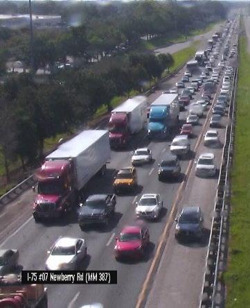
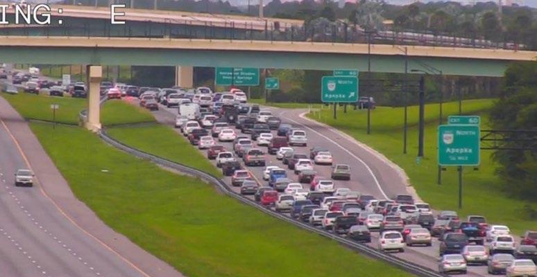
7 Emergency Shoulder Use Inside shoulder use I-75, Florida s Turnpike north terminus to Georgia Line (northbound) I-4, Tampa to Orlando (eastbound) Outside shoulder use I-75, Alligator Alley (eastbound and westbound depending on the storm track) I-10, Jacksonville to I-75 (westbound)


8 Why Emergency Shoulder Use Available continuously- one-way limited to daylight hours Same 24-hour capacity as one-way Reverse direction remains available Emergency and incident response Fuel delivery to evacuation areas Resource staging for quick post storm response Easier setup/maintenance/take down Used one-third as many emergency resources Easily adjustable as traffic patterns changed All interchanges retained full egress/ingress


9 Why Emergency Shoulder Use
10 Hurricane Irma Path

11 Sunday, September 10, 2017 Upgrades to a Category 4 as it makes landfall in the Florida Keys. Downgrades to a Category 3 as it makes landfall in mainland Florida. Downgrades to a Category 2 as it travels north across Florida.
12 Satellite Aerial Image (September 10, 2017) Hurricane Irma north of the Keys approaching landfall in mainland Florida as a Category 3 storm. Hurricane Jose following behind Irma as a Category 3 storm.
13 Hurricane Irma Over Florida Sunday, September 10-1st Landfall (Cudjoe Key, FL): 130 mph, 929 mb Category 4 First Category 4 hurricane to make landfall in Florida since Charley (2004) First major hurricane to make landfall in Florida since Wilma (2005) 929 mb pressure is tied for 7th lowest on record for U.S. landfall with Lake Okeechobee Hurricane of 1928 Sunday, September 10-2nd Landfall (Marco Island, FL): 115 mph, 940 mb Category 3 Exact same latitude/longitude as well as Category at landfall as Wilma (2005): 25.9 N, 81.7 W

14 Monday, September 11, 2017 Downgrades to a Category 1 Hurricane then Tropical Storm as it continues to travel north. Downgrades to Tropical Depression over Georgia.
15 Timeline (Initial Emergency Response) Sunday, September 10, 2017 Landfall in south Florida. Cut and toss crews and windshield damage assessment to start at first light tomorrow in south Florida. Monday, September 11, 2017 Storm tracking up the west side of the state passing Tallahassee around 2PM. Cut and toss crews and windshield damage assessment to start at first light tomorrow in north Florida. Response starting in south Florida. Critical routes for National Guard, Utilities, and Special Needs Shelters open. Majority of state roads cleared and open except for flooded areas. US 1 in the Keys open for legal loads for emergency response to MM 37 (Marathon). State Offices closed. Tuesday, September 12, 2017 Response starting in north Florida. Critical routes for National Guard, Utilities, and Special Needs Shelters open. Majority of state roads cleared and open except for flooded areas. US 1 in the Keys open for legal loads for emergency response to Key West. Concerns with re-entry traffic.
16 Post-Storm Timeline (Emergency Response) Wednesday, September 13, 2017 Santa Fe River cresting at I-75, US 41, US 27, and SR 47. Monitored throughout the night. Friday, September 15, 2017 First day of returning to normal emergency operations. Emergency fuel starting to be released. Saturday, September 16, 2017 Keys opened to returning residents. Friday, September 22, 2017 Concerns and issues with debris contractors. Continued Ongoing Emergency Response Efforts Emergency fuel in Marathon released October 21. Vegetative debris; C&D debris; hazardous trees, stumps, and limbs, etc.
17 Vegetative Debris and Hazardous Tree, Stump, and Limb Removal Vegetative Debris Removal October 9, 2017 thru November 17, Vegetative debris removal complete in all counties except Monroe County. January 28, Vegetative debris removal complete in Monroe County. Total amount of vegetative debris removed was 1,361,415 cubic yards with 1,027,985 cubic yards in Monroe County. Hazardous Tree, Stump, and Limb Removal September 20, 2017 thru December 19, Hazardous Tree, Stump, and Limb removal complete in all counties except Miami-Dade and Monroe Counties. January 28, Hazardous Tree, Stump, and Limb removal complete Monroe County. February 23, Hazardous Tree, Stump, and Limb removal complete in Miami-Dade County. Total number of hazardous trees removed was 9,992. Total number of hazardous limbs (per tree) removed was 110,767.
18 Debris Removed

19 Hazardous Trees Removed

20 Hazardous Hanging Limbs Removed
21 Estimated Costs and Lessons Learned Estimated Department costs to date are $334,003,382. Lessons Learned. Emergency Shoulder Use. Additional corridors developed. Pre-event Contracts. Modifications made to the scope of services. Debris Removal. To be procured as emergency contracts instead of pre-event contracts. Rest Areas. Install emergency generators to power lights, water, and wastewater.
22 Questions?
Tropical Update. 5 PM EDT Sunday, September 10, 2017 Hurricane Irma, Hurricane Jose, Tropical Wave (60%)
") Tropical Update 5 PM EDT Sunday, September 10, 2017 Hurricane Irma, Hurricane Jose, Tropical Wave (60%) This update is intended for government and emergency response officials, and is provided for informational
Tropical Update 5 PM EDT Sunday, September 10, 2017 Hurricane Irma, Hurricane Jose, Tropical Wave (60%) This update is intended for government and emergency response officials, and is provided for informational
Storm Surge Forecast with Shifting Forecast Tracks
 Storm Surge Forecast with Shifting Forecast Tracks Storm Surge Findings in the Florida Keys Jon Rizzo Warning Coordination Meteorologist National Weather Service Florida Keys Florida Keys Life History
Tropical Update. 5 AM EDT Tuesday, September 12, 2017 Post-Tropical Cyclone Irma, Hurricane Jose, & Tropical Wave (10%)
") Tropical Update 5 AM EDT Tuesday, September 12, 2017 Post-Tropical Cyclone Irma, Hurricane Jose, & Tropical Wave (10%) This update is intended for government and emergency response officials, and is provided
Tropical Update 5 AM EDT Tuesday, September 12, 2017 Post-Tropical Cyclone Irma, Hurricane Jose, & Tropical Wave (10%) This update is intended for government and emergency response officials, and is provided
Tropical Update. 5 PM EDT Tuesday, September 5, 2017 Hurricane Irma, Tropical Storm Jose, and Tropical Depression Thirteen
 Tropical Update 5 PM EDT Tuesday, September 5, 2017 Hurricane Irma, Tropical Storm Jose, and Tropical Depression Thirteen This update is intended for government and emergency response officials, and is
Tropical Update. 5 PM EDT Thursday, August 27, 2015 Tropical Storm Erika
 Tropical Update 5 PM EDT Thursday, August 27, 2015 Tropical Storm Erika This update is intended for government and emergency response officials, and is provided for informational and situational awareness
Tropical Update. 5 PM EDT Thursday, September 7, 2017 Hurricane Irma, Hurricane Jose, and Hurricane Katia
 Tropical Update 5 PM EDT Thursday, September 7, 2017 Hurricane Irma, Hurricane Jose, and Hurricane Katia This update is intended for government and emergency response officials, and is provided for informational
A HURRICANE IS COMING. Presented by Atiba Upchurch Broward Emergency Management Division
 A HURRICANE IS COMING Presented by Atiba Upchurch Broward Emergency Management Division Mission Statement To safeguard the lives and property of the people of Broward County from major hazards and emergencies
Are You Ready For Hurricane Season? 2018 Hurricane Talk B Y : S T O R M T E A M 8 M E T E O R O L O G I S T J U L I E P H I L L I P S
 Are You Ready For Hurricane Season? 2018 Hurricane Talk B Y : S T O R M T E A M 8 M E T E O R O L O G I S T J U L I E P H I L L I P S About Me I am Currently a Weekday Meteorologist at WFLA Channel 8.
Miami-Dade County Overview
 Miami-Dade County Overview 2,000 square miles World s busiest cruise port 2.6 million residents Second busiest US airport for international travelers Gateway to the Caribbean and Latin America Natural
Major Hurricane Matthew Briefing Situation Overview
 Major Hurricane Matthew Briefing Situation Overview THIS IS NOW A WORST CASE STORM SURGE SCENARIO Catastrophic Damage is Anticipated for Coastal Areas. Major Hurricane Matthew is still expected to move
Wind field has expanded and is very large. Hurricane Wind field = 100 miles wide, Tropical Storm Wind field = 360 miles wide
 HURRICANE IRMA 12 PM ET Sunday, September 10 2017 Prepared by: Keith Stellman / Kyle Thiem www.weather.gov/atlanta/briefings @NWSAtlanta www.weather.gov/atlanta Situation Overview 11:10 AM EDT Sun Sep
WEDNESDAY 30 TH AUGUST, :57 p.m. Tropical Storm Irma forms in the Atlantic. Don t let your guard down, always #Be Ready.
 Chapter 1 - The Set Up In the days leading up to Irma a series of composed and sobering text messages, presented in truncated form below, from Department of Disaster Management warned us of the pending
Staging for Utility Personnel and Mutual Aid. 1. Hermine- Meeting dates were August 29th_31 st, 2016 and September 1st, 2016.
 Town of Havana, Fl. Response to Review of Electric Utility Hurricane Preparedness and Restoration Actions- Applies only to Hermine and Irma. Maria and Nate posed no serious threat to Havana. Staging for
Tropical Update. 5 AM EDT Wednesday, September 6, 2017 Hurricane Irma, Tropical Storm Jose, and Tropical Storm Katia
 Tropical Update 5 AM EDT Wednesday, September 6, 2017 Hurricane Irma, Tropical Storm Jose, and Tropical Storm Katia This update is intended for government and emergency response officials, and is provided
First Coast TIM Meeting
 First Coast TIM Meeting Tuesday, November 15 th, 2016 Meeting Minutes **Please note: The list of attendees, agenda, and meeting handouts are attached to these meeting minutes. ** Introductions Dee Dee
Major Hurricane Matthew Briefing Situation Overview
 Major Hurricane Matthew Briefing Situation Overview At 5 p.m. Tuesday, Category 4 Hurricane Matthew was about 860 miles South-Southeast of Mayport, Florida, moving north around 10 mph. Maximum sustained
TXWARN Tabletop Exercise: Hurricane Helen
 TXWARN Tabletop Exercise: Hurricane Helen July 31, 2015 Administrative Details In-studio participants and remote participants Situation manual Evaluations Training hours 1 In Studio: Welcome and Introductions
Tropical Update. 12 PM EDT Friday, October 7, 2016 Hurricane Matthew & Tropical Storm Nicole
 Tropical Update 12 PM EDT Friday, October 7, 2016 Hurricane Matthew & Tropical Storm Nicole This update is intended for government and emergency response officials, and is provided for informational and
Tropical Storm Colin Briefing Last Briefing on this System
 Tropical Storm Colin Briefing Last Briefing on this System NWS WFO Jacksonville, Florida Tuesday, June 07, 2016 6:00 a.m. EDT Tropical Storm Colin s Impacts SE Georgia & North Florida Local Watches & Warnings:
Hurricane Wilma Post Storm Data Acquisition Estimated Peak Wind Analysis and Storm Tide Data. December 27, 2005
 Hurricane Wilma Post Storm Data Acquisition Estimated Peak Wind Analysis and Storm Tide Data December 27, 2005 Hurricane Wilma was the sixth major hurricane of the record-breaking 2005 Atlantic hurricane
TROPICAL DEPRESSION HARVEY BRIEFING
 TROPICAL DEPRESSION HARVEY BRIEFING 10:15 PM CDT Wednesday, August 23, 2017 Prepared by: Lara Beal NWSCorpus www.weather.gov/corpuschristi Situation Overview No changes to Watches. Hurricane Watch remains
HURRICANE IRMA. 12 PM ET Saturday, September Prepared by: Kyle Thiem / Sid King.
 HURRICANE IRMA 12 PM ET Saturday, September 9 2017 Prepared by: Kyle Thiem / Sid King www.weather.gov/atlanta/briefings @NWSAtlanta www.weather.gov/atlanta Situation Overview 11:00 AM EDT Sat Sep 9 Location:
Tropical Update 6 AM EDT Friday, October 7, 2016 Hurricane Matthew & Hurricane Nicole
 Tropical Update 6 AM EDT Friday, October 7, 2016 Hurricane Matthew & Hurricane Nicole This update is intended for government and emergency response officials, and is provided for informational and situational
TRAFFIC ALERT FOR WEEK OF February 4 8, 2008
 TRAFFIC ALERT FOR WEEK OF February 4 8, 2008 Highway work zones in the Staunton District The following is a list of highway work that might affect traffic in the Staunton transportation district during
Tropical Update. 5 PM EDT Sunday, October 7, 2018 Tropical Storm Michael, Tropical Storm Leslie, & Invest 92L (30%)
") Tropical Update 5 PM EDT Sunday, October 7, 2018 Tropical Storm Michael, Tropical Storm Leslie, & Invest 92L (30%) This update is intended for government and emergency response officials, and is provided
Tropical Update 5 PM EDT Sunday, October 7, 2018 Tropical Storm Michael, Tropical Storm Leslie, & Invest 92L (30%) This update is intended for government and emergency response officials, and is provided
WEATHER SYSTEMS IMPACTING THE CAYMAN ISLANDS Prepared by the staff of the Cayman Islands National Weather Service
 WEATHER SYSTEMS IMPACTING THE CAYMAN ISLANDS 2008 Prepared by the staff of the Cayman Islands National Weather Service TROPICAL STORM DOLLY Formed 194 miles west of Grand Cayman July 19 th. The tropical
5PM EDT 11, 2017 (21 UTC)
") REPORT DATE: September 11, 2017 HURRICANE IRMA Tropical Storm Irma Date September 11, 2017 Time 5PM EDT (21 UTC) Position 31.5N, 84.0W Maximum Sustained Winds Motion Minimum Central Pressure Status 50
REPORT DATE: September 11, 2017 HURRICANE IRMA Tropical Storm Irma Date September 11, 2017 Time 5PM EDT (21 UTC) Position 31.5N, 84.0W Maximum Sustained Winds Motion Minimum Central Pressure Status 50
June 2-5, 2018 Pasadena, CA Pasadena Convention Center. #aphl
 June 2-5, 2018 Pasadena, CA Pasadena Convention Center #aphl Florida s Response to Natural Disasters Andrew Cannons, Ph.D. Laboratory Director Bureau of Public Health Laboratories (BPHL)-Tampa Florida
Tropical Update. 5 AM EDT Monday, October 8, 2018 Tropical Storm Michael, Tropical Storm Leslie, Invest 92L (10%) & African Tropical Wave (50%)
 & African Tropical Wave (50%)") Tropical Update 5 AM EDT Monday, October 8, 2018 Tropical Storm Michael, Tropical Storm Leslie, Invest 92L (10%) & African Tropical Wave (50%) This update is intended for government and emergency response
Tropical Update 5 AM EDT Monday, October 8, 2018 Tropical Storm Michael, Tropical Storm Leslie, Invest 92L (10%) & African Tropical Wave (50%) This update is intended for government and emergency response
Tropical Update. 11 AM EDT Tuesday, October 9, 2018 Hurricane Michael, Tropical Storm Leslie, Tropical Storm Nadine
 Tropical Update 11 AM EDT Tuesday, October 9, 2018 Hurricane Michael, Tropical Storm Leslie, Tropical Storm Nadine This update is intended for government and emergency response officials, and is provided
NOAA s National Weather Service Philadelphia/Mt. Holly NJ
 Next Briefing Package: Thursday, October 1, 2015 no later than 300 PM Hazards and Impacts: Overview: A dangerous weather pattern is developing for our region. Threats include very heavy rainfall, inland
West Tennessee Construction June 14-21, 2017
 FOR IMMEDIATE RELEASE Wednesday, June 14, 2017 CONTACT: Nichole Lawrence CELL: 731-225-6041 West Tennessee Construction June 14-21, 2017 BENTON COUNTY, I-40 Truck Climbing Lane Wednesday, June 7 through
Hurricane Preparation and Recovery. October 11, 2011 Jon Nance, Chief Engineer, NCDOT
 Hurricane Preparation and Recovery October 11, 2011 Jon Nance, Chief Engineer, NCDOT North Carolina & Severe Weather Our state often bears the brunt of storms, which include: Ice storms Snow storms Heavy
Lessons Learned from Hurricane Harvey and Irma
 EOL Visit to NSF 3 March 2016 Lessons Learned from Hurricane Harvey and Irma Wen-Chau Lee National Center for Atmospheric Research 23 November 2017 Outline: Meteorological elements of the active 2017 Atlantic
FLORIDA DIVISION OF EMERGENCY MANAGEMENT STATE WATCH OFFICE DAILY INCIDENT REPORT
 FLORIDA DIVISION OF EMERGENCY MANAGEMENT STATE WATCH OFFICE DAILY INCIDENT REPORT Incident Number: 2018-6664 Incident Name: Southbound I-75 Closed Occurred: 10/26/2018 01:26 ET Reported to SWO: 10/26/2018
Monroe County: Key West and Lower Keys
 FDOT PROJECT UPDATES June 15-21, 2015 Monroe County: Key West and Lower Keys Monroe County projects website: www.fdotmonroe.com Opt Out: If you no longer wish to receive these weekly notifications, please
SITUATION REPORT #7 September 8 th, 2017
 MCO AIRPORT EMERGENCY OPERATIONS CENTER SITUATION REPORT #7 September 8 th, 2017 STATE OF FLORIDA REGION V FEMA REGION IV GENERAL INFORMATION Local State of Emergency Declaration Number: 17-235 Dated:
The Tampa Bay Catastrophic Plan Presentation to CFGIS Users Group FDOT District 5 Urban Offices - Orlando July 30, 2010
 The Tampa Bay Catastrophic Plan Presentation to CFGIS Users Group FDOT District 5 Urban Offices - Orlando July 30, 2010 Brady Smith Senior Planner Tampa Bay Regional Planning Council Introduction Recent
Tropical Update. 11 AM EDT Wednesday, October 10, 2018 Hurricane Michael, Hurricane Leslie & Tropical Storm Nadine, Caribbean Low (40%)
") Tropical Update 11 AM EDT Wednesday, October 10, 2018 Hurricane Michael, Hurricane Leslie & Tropical Storm Nadine, Caribbean Low (40%) This update is intended for government and emergency response officials,
Tropical Update 11 AM EDT Wednesday, October 10, 2018 Hurricane Michael, Hurricane Leslie & Tropical Storm Nadine, Caribbean Low (40%) This update is intended for government and emergency response officials,
Date: 27 April UF Research Contract Number: Project Date: Project Start: 6 November 2017 Project End: 30 June 2018
 Date: 27 April 2018 Project: Performance of Single-Family Residential Buildings in Hurricane Irma Evaluating the Impact of the 1st March 2002 Florida Building Code and Homeowner/Occupant Survey on Risk
TROPICAL CYCLONE TORNADOES
 TROPICAL CYCLONE TORNADOES 2018 GOVERNOR S HURRICANE CONFERENCE TUESDAY, MAY 15, 2018 WILL ULRICH NWS FORECAST OFFICE MELBOURNE WHERE ARE THE TORNADOES? WHERE ARE THE TORNADOES? C B A WEST MELBOURNE, FL
2008 Hurricane Caravan. Daniel Noah Meteorologist National Weather Service x1 May 22, 2008
 2008 Hurricane Caravan Daniel Noah Meteorologist National Weather Service daniel.noah@noaa.gov, 813-645-2323 x1 May 22, 2008 National Weather Service We never close! Open 24 hours a day 365 days per year
Hurricane Basics and Preparedness. Jim Weyman Director, Central Pacific Hurricane Center Phone Office:
 Hurricane Basics and Preparedness Jim Weyman Director, Central Pacific Hurricane Center Phone Office: 973-5270 james.weyman@noaa.gov United States Hurricane/Typhoon Centers National Hurricane Center, Miami
Tropical Update. 5 AM EDT Thursday, September 7, 2017 Hurricane Irma, Hurricane Jose, and Hurricane Katia
 Tropical Update 5 AM EDT Thursday, September 7, 2017 Hurricane Irma, Hurricane Jose, and Hurricane Katia This update is intended for government and emergency response officials, and is provided for informational
photo courtesy of
 BRITISH VIRGIN ISLANDS REPORT TROPICAL STORM JEANNE photo courtesy of www.bviplatinum.com PREPARED BY THE DEPARTMENT OF DISASTER MANAGEMENT 1 EVENT 13 th -16 th September, 2004 TROPICAL STORM JEANNE Sequence
NOAA s National Weather Service Philadelphia/Mt. Holly NJ
 Next Briefing Package: Friday, October 2, 2015 no later than 300 PM Hazards and Impacts: Overview: A dangerous weather pattern still threatens our region. Threats include very heavy rainfall, inland river
Current Situation Report Hurricane Irma - Atlantic Ocean - Current Situation Report - 08 Sep 17 (Update 03)
") Current Situation Report Hurricane Irma - Atlantic Ocean - Current Situation Report - 08 Sep 17 (Update 03) Date As Of: 09/08/2017 21:39:11 Sitrep Update #: 03 Incident Start Time: 09/06/2017 12:09:38
Current Situation Report Hurricane Irma - Atlantic Ocean - Current Situation Report - 08 Sep 17 (Update 03) Date As Of: 09/08/2017 21:39:11 Sitrep Update #: 03 Incident Start Time: 09/06/2017 12:09:38
Annual Collision Report
 2016 Annual Collision Report Contents The Annual Collision Report is a summary of statistics associated with traffic collisions that occurred in the City of Winnipeg. This information is provided by Manitoba
Weather Research Center
 Weather Research Center 3227 Audley Houston, Texas 77098 Phone: 713-529-3076 Fax: 713-528-3538 E-mail: wrc@wxresearch.org Press Release For Immediate Release November 29, 2005 For Information Contact:
South Florida Storm Surge
 South Florida Storm Surge Highest storm tide Everglades City/Chokoloskee in area closest to landfall Nevertheless, storm tide as high as 6 feet along Biscayne Bay about 90 miles from eye of Irma! Closer
National Situation Report As of 3:00 a.m. EDT, Thursday, September 21, 2017 Table of Contents Current Operations Monitoring Recovery
 25k Overview National Situation Report As of 3:00 a.m. EDT, Thursday, September 21, 2017 Table of Contents Current Operations Monitoring Recovery FEMA Headquarters Status FEMA Region Status NRCC Level
SITUATION REPORT: February 2018 Ohio River Flooding
 SITUATION REPORT: February 2018 Ohio River Flooding Hamilton County Emergency Management Situation Report: #28 Date of Issue: 03/06/2018 Time Issued: 1400 hrs. Prepared By: Irvin Jones Approved By: Ryan
GC Briefing. Weather Sentinel Tropical Storm Michael. Status at 8 AM EDT (12 UTC) Today (NHC) Discussion. October 11, 2018
 Today (NHC) Discussion. October 11, 2018") GC Briefing Weather Sentinel Tropical Storm Michael October 11, 2018 After making landfall as a high-end category-4 hurricane on the Florida Panhandle, Michael weakened to tropical storm status early this
GC Briefing Weather Sentinel Tropical Storm Michael October 11, 2018 After making landfall as a high-end category-4 hurricane on the Florida Panhandle, Michael weakened to tropical storm status early this
Hurricane Irma Page 1 HURRTRAK RM/Pro 2017 Summary Report for Tampa, FL 09/09/ EDT, Adv. # 43
 Hurricane Irma Page 1 Description of impact to Tampa, FL, Tampa, FL, is expected to receive a major impact from Hurricane Irma. The forecast maximum wind for this location has decreased since the last
STORM HISTORY FOR COLLIER COUNTY
 STORM HISTORY FOR COLLIER COUNTY In 1960, when hurricane 'Donna' struck, there were approximately 15,500 people living full time in Collier County. Today there are more than 330,000 residents, most of
Situation Report KC#56896 Winter Storm 3/13-15/2017 Pennsylvania Emergency Management Agency
 Situation Report KC#56896 Winter Storm 3/13-15/2017 Pennsylvania Emergency Management Agency Report as of 14 Mar 2017 at 1000 hours Situation Report #03 *Changes indicated in Blue Contents: I. Incident
Hurricane Sandy October 28 th 31 st 2012
 Hurricane Sandy October 28 th 31 st 2012 Prepared 530 PM EDT Saturday October 27, 2012 Gary Szatkowski NOAA s NJ Forecast Office Weather.gov/phi Purpose of Briefing Briefing #7 for event Promote situational
National Situation Report As of 3:00 a.m. EDT, Sunday, October 8, 2017 Table of Contents Current Operations Monitoring Recovery
 Overview National Situation Report As of 3:00 a.m. EDT, Sunday, October 8, 2017 Table of Contents Current Operations Monitoring Recovery FEMA Headquarters Status FEMA Region Status NRCC Level I (24/7)
IWT Scenario 2 Integrated Warning Team Workshop National Weather Service Albany, NY October 31, 2014
 IWT Scenario 2 Integrated Warning Team Workshop National Weather Service Albany, NY October 31, 2014 09 10 11 12 13 Scenario 2 Timeline December 9-13 Tue Wed Thu Fri Sat Tue, Dec. 9 @ 5 am 2014 2014 2014
NWS HURRICANES June 3, 2015
 NWS HURRICANES June 3, 2015 Hurricane Season June 1 November 30 2 What s the concern? All tropical systems passing within 125nm of central Maryland since 1950 Mid-Atlantic Hurricanes Greatest Risk: August
Hurricane Matthew. Life Threatening Flash Flooding Likely. National Weather Service Wilmington NC. Josh Weiss, Meteorologist
 Hurricane Matthew Life Threatening Flash Flooding Likely Threat Assessment for northeast South Carolina & southeast North Carolina National Weather Service Wilmington NC 630 PM EDT Friday October 7, 2016
Shutdown: NYCT s Extreme Weather Strategy for Safety and Recovery
 Shutdown: NYCT s Extreme Weather Strategy for Safety and Recovery Larry Gould Senior Director, Operations Analysis New York City Transit 0 NYCT Subway: 5.3 Million Riders Daily 468 stations 660 track miles
Table 1. August average temperatures and departures from normal ( F) for selected cities.
 for selected cities.") Climate Summary for Florida August 2016 Prepared by Lydia Stefanova and David Zierden Florida Climate Center, The Florida State University, Tallahassee, Florida Online at: http://climatecenter.fsu.edu/products-services/summaries
Climate Summary for Florida August 2016 Prepared by Lydia Stefanova and David Zierden Florida Climate Center, The Florida State University, Tallahassee, Florida Online at: http://climatecenter.fsu.edu/products-services/summaries
Hurricane Florence Operations Report 5:00 PM September 15, 2018
 Hurricane Florence Operations Report 5:00 PM September 15, 2018 SCDOT Operations Mode: Response SEOC Operations Mode: OPCON1 Statewide Summary SCDOT is responding to impacts from Hurricane Florence. Crews
Daily Operations Briefing. Thursday, November 9, :30 a.m. EST
 Daily Operations Briefing Thursday, November 9, 2017 8:30 a.m. EST Significant Activity Nov 8-9 Significant Events: Tropical Cyclones Harvey, Irma, and Maria Tropical Activity: Atlantic Tropical Storm
Daily Operations Briefing. Monday, October 9, :30 a.m. EDT
 Daily Operations Briefing Monday, October 9, 2017 8:30 a.m. EDT Significant Activity Oct 8-9 Significant Events: Response for Hurricane Maria Tropical Activity: Atlantic Tropical Depression Seventeen Eastern
Hurricane Irma Page 1 HURRTRAK RM/Pro 2017 Summary Report for Tampa, FL 09/10/ EDT, Adv. # 46
 Hurricane Irma Page 1 Description of impact to Tampa, FL, Tampa, FL, is expected to receive a major impact from Hurricane Irma. The forecast maximum wind for this location has increased since the last
Canes on Canes: Keeping South Florida Prepared During the Calm Before the Storm. Matt Onderlinde and Pete Finocchio
 Canes on Canes: Keeping South Florida Prepared During the Calm Before the Storm Matt Onderlinde and Pete Finocchio Outline The Science of Hurricanes Why and When South Floridians Must Be Weather-Ready
Hurricane Season 2018
 Hurricane Season 2018 Mission Protect LIFE and Property (Save Lives and Livelihoods) NOAA/ National Weather Service We are NOT a 9-to-5 agency. We operate 24/7/365 serving communities. We are available
Tropical Update 11 AM EDT Thursday, September 6, 2018 Tropical Depression Gordon, Hurricane Florence, Invest 92L (90%) & African Tropical Wave (50%)
 & African Tropical Wave (50%)") Tropical Update 11 AM EDT Thursday, September 6, 2018 Tropical Depression Gordon, Hurricane Florence, Invest 92L (90%) & African Tropical Wave (50%) This update is intended for government and emergency
Tropical Update 11 AM EDT Thursday, September 6, 2018 Tropical Depression Gordon, Hurricane Florence, Invest 92L (90%) & African Tropical Wave (50%) This update is intended for government and emergency
IWT Scenario 1 Integrated Warning Team Workshop National Weather Service Albany, NY October 31, 2014
 Integrated Warning Team Workshop National Weather Service Albany, NY October 31, 2014 23 24 25 26 27 Scenario 1 Timeline November 23-27 Sun Mon Tue Wed Thu Thanksgiving Day Sunday, Nov. 23 @ 430 pm NWS
FLORIDA DIVISION OF EMERGENCY MANAGEMENT STATE WATCH OFFICE DAILY INCIDENT REPORT
 FLORIDA DIVISION OF EMERGENCY MANAGEMENT STATE WATCH OFFICE DAILY INCIDENT REPORT Incident Number: 2018-7477 Incident Name: Woodville Highway Closed Occurred: 12/6/2018 05:29 ET Reported to SWO: 12/6/2018
Septem ber 28, 2016 EL PASO, Texas
 September 28, 2016 EL PASO, Texas Crews from Paso del Norte Trackworks will finalize underground utility work and begin laying rail on a portion of Kansas Street thru Downtown El Paso in the coming weeks,
SITUATION REPORT # 7 NEW JERSEY STATE EMERGENCY OPERATIONS CENTER October 29, 2012, 8:00 A.M.
 SITUATION REPORT # 7 NEW JERSEY STATE EMERGENCY OPERATIONS CENTER October 29, 2012, 8:00 A.M. A. CURRENT SYNOPSIS: The NJ ROIC and NJOEM are responding to the onset of Tropical force winds from Hurricane
California OES Weather Threat Briefing
 California OES Weather Threat Briefing Wednesday, January 16, 2019 9:00 AM PST Day 1: Strong winds, heavy mountain snow and heavy rain with isolated thunderstorms across much of the state through Thursday
The Sunland Park flyover ramp is set to close the week of March 19 until early summer
 March 2, 2018 The Sunland Park flyover ramp is set to close the week of March 19 until early summer GO 10 is targeting the week of March 19 to close the Sunland Park Drive flyover entrance ramp to I 10
Table-Top Exercise for Emergency Preparedness Evaluation: Little Anse, Isle Madame
 Table-Top Exercise for Emergency Preparedness Evaluation: Little Anse, Isle Madame Alexander Chung, M.Sc. Candidate C-Change Student Research Associate May 2013 The Community of Little Anse Coastal community
Winter Storm Update. Through Late Afternoon: Jacksonville, FL Weather Forecast Office. Northeast Florida and Southeast Georgia
 Winter Storm Update Through Late Afternoon: Winter Storm Warning for all of Southeast GA and portions of Suwannee Valley and I-10 Corridor west of Jacksonville. Dangerous ice storm expected from Live Oak
Hurricane Irma. City of Cocoa Beach September 8 12, 2017
 Hurricane Irma City of Cocoa Beach September 8 12, 2017 Monitoring prior to landfall Expected effects What happened What went well What didn t go well Changes and improvements After Action Outline Storm
President s Day Weekend Storm Community Meeting and Workshop April 17, 2017
 President s Day Weekend Storm Community Meeting and Workshop April 17, 2017 Meeting outline 1. Progress update on the City of San Jose s recovery efforts 2. Water district presentation on: Weather situation
Hydrologic Briefing Tropical Storm Harvey
 Hydrologic Briefing Tropical Storm Harvey 10:30 AM CDT Sunday, August 27, 2017 Prepared by: John Metz NWSCorpus www.weather.gov/corpuschristi Situation Overview Tropical Storm Harvey Harvey to remain a
Significant Flooding Expected
 Significant Flooding Expected Decision Support Briefing #5 As of: 9:00 AM September 14, 2018 What Has Changed? Flash Flood Watch now in effect for part of area, will be expanded later today 9/14/2018 9:23
Preliminary Assessment of 2017 Atlantic Hurricane Season. Phil Klotzbach. Department of Atmospheric Science. Phil Klotzbach
 Atlantic Basin Basin Tropical Seasonal Cyclone Hurricane Climatology Prediction and Preliminary Assessment of 2017 Atlantic Hurricane Season Phil Klotzbach Department of Atmospheric Science Colorado Phil
Daily Operations Briefing. Wednesday, November 8, :30 a.m. EST
 Daily Operations Briefing Wednesday, November 8, 2017 8:30 a.m. EST Significant Activity Nov 7-8 Significant Events: Tropical Cyclones Harvey, Irma, and Maria Tropical Activity: Atlantic Tropical Storm
Managing an Extreme Weather Event of Prolonged Duration May 22, 2013
 Managing an Extreme Weather Event of Prolonged Duration May 22, 2013 MISSOURI RIVER FLOOD OF 2011 M I C H A E L J. K E N N E R L Y P. E. D I R E C T O R O F T H E O F F I C E O F D E S I G N I O W A D
Irma leaves millions without power and thousands homeless in Florida
 Irma leaves millions without power and thousands homeless in Florida By Associated Press, adapted by Newsela staff on 09.12.17 Word Count 794 Level 1140L Kelly McClenthen (left) returns to see the flood
Director, Operations Services, Met-Ed
 Director, Operations Services, Met-Ed Pennsylvania House Republican Policy Committee Hearing on Storm Response Tobyhanna Township Municipal Building Pocono Pines, Pa. August 9, 2018 Planning and Forecast
TROPICAL STORM NATE BRIEFING
 TROPICAL STORM NATE BRIEFING 5:00 AM CDT Friday, October 6, 2017 Prepared by: NWS NWSNewOrleans www.weather.gov/neworleans Situation Overview No significant changes to the track forecast this morning.
Fast and Furious Rebuilding and Widening the I-90 West Corridor
 Fast and Furious Rebuilding and Widening the I-90 West Corridor Peter Foernssler, P.E., S.E. Deputy Chief, Illinois Tollway Marty Ross, P.E. Design Corridor Manager, TranSystems Jason Wenberg, P.E. Construction
Hurricane Lane. Hawaiian Islands, August By Ian Robertson 1, Ph.D., P.E.
 Hurricane Lane Hawaiian Islands, August 2018 By Ian Robertson 1, Ph.D., P.E. Hurricane Lane, a major Pacific Ocean hurricane, narrowly missed making landfall on the main Hawaiian Islands, but still caused
Local Storm Surge Considerations. Al Sandrik Warning Coordination Meteorologist National Weather Service Office Jacksonville, Florida
 Local Storm Surge Considerations Al Sandrik Warning Coordination Meteorologist National Weather Service Office Jacksonville, Florida SLOSH Display Program Some Definitions: Astronomical Tide: The daily
Ensuring the Building of Community Resiliency through Effective Partnership December 4, 2017 Melia Nassau Beach Valentino A. Hanna
 Ensuring the Building of Community Resiliency through Effective Partnership December 4, 2017 Melia Nassau Beach Valentino A. Hanna Sol Caribbean Presence What Occurred Mega Storms 2017 Cat 5 Hurricane
Bonnie, Charley, Ivan, Frances & Jeanne: Florida s Uninvited Visitors of 2004
 A Presentation by the Florida Chapter American Public Works Association Bonnie, Charley, Ivan, Frances & Jeanne: Florida s Uninvited Visitors of 2004 Jeffrey A. Wilson, PE, PWLF 2004-2005 Florida APWA
RSMC-Miami Update Daniel Brown Warning Coordination Meteorologist
 RSMC-Miami Update 2016 Daniel Brown Warning Coordination Meteorologist L-0324 Emergency Management Hurricane Preparedness Training Course Funding provided by FEMA s National Hurricane Program - partnership
Lessons Learned Using ESRI s Network Analyst to Optimize Snow Treatment Routes in Kentucky
 Lessons Learned Using ESRI s Network Analyst to Optimize Snow Treatment Routes in Kentucky Ben Blandford, PhD Eric Green, PE, PhD Candidate Kentucky Transportation Center University of Kentucky Overview
I-10 East at Redd closes for 24 hours this Sunday, Feb 11. Then, I-10 West at Resler closes for 27 hours on Feb 25
 NEWS RELEASE a TxDOT Project For immediate release EL PASO DISTRICT Jennifer Wright (915) 790-4340 Jennifer.Wright3@txdot.gov February 9, 2018 I-10 East at Redd closes for 24 hours this Sunday, Feb 11
Hydrologic Briefing Tropical Storm Harvey
 Hydrologic Briefing Tropical Storm Harvey 5:00 PM CDT Sunday, August 27, 2017 Prepared by: Jennifer Dunn/Christina Barron NWSCorpus www.weather.gov/corpuschristi Situation Overview Tropical Storm Harvey
FLORIDA DIVISION OF EMERGENCY MANAGEMENT STATE WATCH OFFICE DAILY INCIDENT REPORT
 FLORIDA DIVISION OF EMERGENCY MANAGEMENT STATE WATCH OFFICE DAILY INCIDENT REPORT Incident Number: 2018-6310 Incident Name: River Flood Warning (Suwannee River at Fowler Bluff CR 347) Occurred: 10/10/2018
Superstorm Sandy What Risk Managers and Underwriters Learned
 Superstorm Sandy What Risk Managers and Underwriters Learned Gary Ladman Vice President, Property Underwriting AEGIS Insurance Services, Inc. Superstorm Sandy Change in the Weather Recent years appears
Climate Outlook through 2100 South Florida Ecological Services Office Vero Beach, FL September 9, 2014
 Climate Outlook through 2100 South Florida Ecological Services Office Vero Beach, FL September 9, 2014 Short Term Drought Map: Short-term (