Subsidence is the sinking or collapse of a portion of the land surface. The movement involved in subsidence is essentially vertical; little or no
|
|
|
- Claribel Tate
- 5 years ago
- Views:
Transcription

1 1
2 Subsidence is the sinking or collapse of a portion of the land surface. The movement involved in subsidence is essentially vertical; little or no horizontal motion is involved. It may take the form of a sudden, dramatic collapse or a slow, almost imperceptible lowering. 2


3 Carbonate Dissolution and Karst Topography Dissolution Caves are large underground open spaces. Caves come in many shapes and sizes. A large cave or system of interconnected cave chambers is called a cavern. The Carlsbad Caverns in southeastern New Mexico include a chamber that is 1200 m long, 190 m wide, and 100 m high. 3
 falling through the atmosphere and percolating the ground dissolves carbon dioxide (CO 2 ) gas from the air and soil, forming carbonic acid (H 2 CO")
, magnesium (Mg ++ ), and bicarbonate (HCO 3- ).")

4 Caves are formed through a chemical weathering process (dissolution) in which carbonate rocks are dissolved by circulating groundwater. Water (H 2 O) falling through the atmosphere and percolating the ground dissolves carbon dioxide (CO 2 ) gas from the air and soil, forming carbonic acid (H 2 CO 3 ). As the carbonic acid infiltrates the ground and contacts the bedrock surface, it reacts readily with limestone (CaCO 3 ) and/or dolomite (CaMg(CO 3 ) 3 ). Caves develop as limestone or dolomite is dissolved into component ions of calcium (Ca ++ ), magnesium (Mg ++ ), and bicarbonate (HCO 3- ). Dissolution of limestone or dolomite is most intensive along pre-existing openings in the rock, such as joints, fractures, and bedding planes. When the groundwater becomes oversaturated with dissolved minerals, further dissolution is not possible, and carbonate salts of calcium and magnesium may precipitate from the water, often forming interesting shapes such as stalactites. 4

5 The rate of cave formation is related to the rate of dissolution. In areas where the water is acidic, the rate of dissolution increases with increasing velocity of flow. As a passage grows and the flow becomes more rapid and turbulent, the rate of dissolution increases. The development of a continuous passage by slowly percolating waters has been estimated to take up to 10,000 years, and further enlargement of the passage by more rapidly flowing water to create a fully developed cave system may take an additional 10,000 to 1 million years. 5

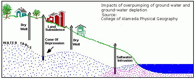
 is topography")


6 Karst Topography Karst topography (after the Karst region of the former Yugoslavia) is topography characterized by many small, closed basins and a disrupted drainage pattern whereby streams disappear into the ground and eventually appear elsewhere in large springs. 6


7 The most common type of karst terrain is sinkhole karst, a landscape dotted with closely spaced circular collapse basins of various sizes and shapes. In contrast to a cave, a sinkhole is a large dissolution cavity that is open to the sky. Some sinkholes are caves whose roofs have collapsed; these are sometimes called collapse sinkholes (or solution sinkholes). Others are formed at the surface in places where rainwater is freshly charged with carbon dioxide and hence is most effective as a solvent. Some sinkholes are funnel shaped; others have high, vertical sides. 7


8 Some sinkholes are formed catastrophically. The sinkhole in Winter Park, Florida was formed by the collapse of surface materials into a preexisting cavity in underlying carbonate rocks. The cavern was connected to near-surface rocks and unconsolidated overburden by an open, chimneylike passageway called an aven. Formation of the sinkhole was initiated by raveling, or gradual downward movement of unconsolidated material into the aven. Raveling eventually left the roof materials unsupported; surface fractures began to develop and the roof eventually collapsed, filling the aven with sediment and debris. Sinkhole formation, also, can be initiated by the sudden wholesale collapse of the bedrock roof into the underground void, a process called stoping. 8


9 Removal of Solids and Mine-Related Collapse There are other ways in which the removal of solid materials can create spaces underground that may result in subsidence. Removal of Salt In 1980 a sinkhole 110 m wide and 34 m deep developed in this manner near Kermit, Texas. This depression, called the Wink Sink, appeared without warning and grew to its full size within 48 hours. Groundwater had dissolved caverns in underlying salt beds in much the same manner as that described earlier for carbonate terrains. Because rock salt (composed mainly of the mineral halite, NaCl) can be dissolved by groundwater, karst terrains and sinkholes can develop in areas underlain by salt as well as in carbonate terrains. Wink Sink in 2002 Wink Sink in


10 One technique used for mining salt is to inject fluids and induce dissolution of the salt underground so that it can be withdrawn in a liquid state. This is called solution mining. When the salt-saturated solution is pumped out it leaves cavities in the rock, thereby weakening the support for overlying material. 10


11 In 1974 solution mining of salt was directly responsible for the rapid development of a water-filled sinkhole 300 m in diameter in Hutchinson, Kansas. Cargill Sinkhole October 21, 1974 Cargill Plant Layout, Showing North and South Sinkholes Cross Section Through South Sinkhole, Cargill Site Cargill Sinkhole November 12,


12 Coal Mining Areas in which coal is mined are susceptible to subsidence. Coal is commonly mined underground using the room-and-pillar method, in which large masses of coal are removed, creating the rooms, and columns of coal are left behind to form the supporting pillars. 12

13 In the past, many mining companies removed as much coal as possible, even from seams relatively near the surface. In some cases, subsidence occurred because too much coal was removed, and the pillars left behind could not support the weight of the overburden. In other cases, the mine was excavated too close to the surface and the roof material between the pillars collapsed. Some relatively recent episodes of subsidence can be attributed to mining done 50 years ago or more. Grasslands near the town of Sheridan, Wyoming, are scarred and pitted with features resulting from subsidence of the ground surface into underground rooms from which coal was mined. Most mining activities associated with the subsidence ended decades ago. The pattern of the subsidence features reveals the layout of the underground rooms and pillars of the former mines. 13

14 Subsidence Caused by Fluid Withdrawal Subsidence resulting from the withdrawal of fluid can be caused by human activities. The fluids most often involved are groundwater, oil, natural gas, and associated brines, as well as mixtures of stream and water used for geothermal energy. Water, Oil, and Gas Subsidence is often caused by removal of subsurface water, especially if the rate of removal is faster than the rate of replenishment. 14


15 When groundwater is pumped out of an aquifer, the pumping creates a depression in the surface of the water table in the shape of an inverted cone (called cone of depression). When many pumped wells are close together, these cones of depressions may begin to overlap. This can cause a regional depression in the level of the water table. Regional lowering of the water table commonly leads to ground subsidence in the area overlying the aquifer. 15
16 16


17 Oil and Natural gas are both fluids that can exist in the pore spaces and fractures of rock, just like water. When oil and natural gas are withdrawn from regions in the Earth near the surface, fluid pressure provided by these fluids is reduced. With a reduction in fluid pressure, the pore spaces begin to close and the sediment may start to compact resulting in subsidence of the surface. 17


18 This has occurred recently in the oil fields of southern California. For example, in the Wilmington oil field of Long Beach, California, subsidence was first recognized in 1940 due to withdrawal of oil from the subsurface. The area affected was about 50 km 2. Near the center of this area, the surface subsided by up to 9 meters. In 1958 repressurization of the area was attempted by pumping fluids back into the rocks below. By 1962 further subsidence had been greatly reduced, and the area continuing to subside had been reduced to 8 km 2. Still, up to this point, very little uplift had occurred to restore the area to its original elevation. This subsidence event has cost over $100 million. 18


19 Sinking Cities Cities built on unconsolidated sediments consisting of clays, silt, peat, and sand are particularly susceptible to subsidence. Such areas are common in delta areas, where rivers empty into the oceans, along floodplains adjacent to rivers, and in coastal marsh lands. In such settings, subsidence is a natural process. Sediments deposited by the rivers and oceans get buried, and the weight of the overlying, newly deposited sediment, compacts the sediment and the material subsides. 19

20 Building cities in such areas aggravates the problem for several reasons. Construction of buildings and streets adds weight to the region and further compacts the sediment. Often the areas have to be drained in order to be occupied. This results in lowering of the water table and leads to hydrocompaction. Often the groundwater is used as a source of water for both human consumption and industrial use. This also results in lowering the water table and further hydrocompaction. Levees and dams are often built to prevent or control flooding. This shuts off the natural supply of new sediment to the area. In a natural setting sedimentation resulting from floods helps replenish the sediment that subsides and thus builds new material over the subsiding sediment, decreasing the overall rate of subsidence. When the sediment supply is cut off, the replenishment does not occur and the rate of subsidence is enhanced. 20

21 The table below shows a list of cities throughout the world that have been experiencing subsidence problems. Note that most of these cities are coastal cities like London, Houston, and Venice, or are built on river flood plains and deltas, like New Orleans, Baton Rouge, and the San Joaquin Valley of central California. Coastal Inland Maximum Subsidence (m) Area Affected (km 2 ) London Venice Taipei Shanghai Houston ,100 San Jose New Orleans San Joaquin Valley ,500 Baton Rouge

22 Predicting and Mitigating Subsidence Hazards The exact place and time of a disaster related to subsidence CANNOT usually be predicted with any degree of certainty. This is true of both slow subsidence related to fluid withdrawal and sudden subsidence related to sinkhole formation or mine collapse. Mitigation is the best approach to these hazards. In an ideal world, all areas susceptible to such hazards would be well known and actions would be taken to either avoid causing the problem if it is human related, or avoid inhabitance of such areas if they are prone to natural subsidence. 22


23 For subsidence caused by sudden collapse of the ground to form sinkholes, several measures can be taken. Geologists can make maps of areas known to be underlain by rocks like limestone, gypsum, or salt, that are susceptible to dissolution by fluids. Based on knowledge of the areas, whether active dissolution is occurring or has occurred in the recent past, and knowing something about the depth below the surface where these features occur, hazard maps can be constructed. Once these areas have been identified, detailed studies using drill holes, or ground penetrating radar can be used to locate open cavities beneath the surface. These areas can then be avoided when time comes for decisions about land use. In areas where there is a possibility of sudden collapse, one should be aware of any cracks that form in the ground, especially if the cracks start to form a circular or elliptical pattern. Such ground cracking may be an indication that a collapse event is imminent. In areas located above known mining operations or former mining operations, maps can be constructed based on knowledge of the actual locations of open cavities beneath the surface. Such maps can then be used as a guide for land use planning. Currently laws are in place to prevent active mining beneath urban areas, but these laws did not always exist, and older mines could still cause problems. 23

24 Where fluid withdrawal is the main cause of subsidence, Information on the rate of fluid withdrawal should be determined and combined with studies of the material in the subsurface based on sampling with drill core methods. If subsidence is suspected or observed, human activities can be modified to prevent further subsidence. For example new sources of water can often be found, or waste water can be treated and pumped back into the ground to help maintain the level of the water table, maintain fluid pressure, or re-hydrate hydrocompacting clays and peat. Fluid withdrawal problems are complicated where laws are in conflict. Rights to withdrawal of an underground resource like water or oil usually take precedence over the rights to sue for damages that might result from subsidence. 24
Land Subsidence. Land subsidence is defined as the lowering of the land surface.
 Land Subsidence Land subsidence is defined as the lowering of the land surface. Many different factors can cause the land surface to subside. Subsidence can occur rapidly due to: a sinkhole or under ground
Lecture 15: Subsidence
 Lecture 15: Subsidence Key Questions 1. How does removal of groundwater cause subsidence on a regional scale? 2. Under what conditions does a building sink into sediment? 3. Why do clays consolidate more
Chapter 14. Groundwater
 Chapter 14 Groundwater Importance of groundwater! Groundwater is water found in the pores of soil and sediment, plus narrow fractures in bedrock! Groundwater is the largest reservoir of fresh water that
STUDY GUIDE FOR CONTENT MASTERY. Movement and Storage of Groundwater
 Groundwater SECTION 10.1 Movement and Storage of Groundwater In your textbook, read about the hydrosphere, precipitation and groundwater, and groundwater storage. Use the following terms to complete the
 12 10 8 6 4 2 0 40-50 50-60 60-70 70-80 80-90 90-100 Fresh Water What we will cover The Hydrologic Cycle River systems Floods Groundwater Caves and Karst Topography Hot springs Distribution of water in
Essentials of Geology, 11e
 Essentials of Geology, 11e Groundwater Chapter 10 Instructor Jennifer Barson Spokane Falls Community College Geology 101 Stanley Hatfield Southwestern Illinois Co Jennifer Cole Northeastern University
Chapter 13. Groundwater
 Chapter 13 Groundwater Introduction Groundwater is all subsurface water that completely fills the pores and other open spaces in rocks, sediments, and soil. Groundwater is responsible for forming beautiful
6.1 Water. The Water Cycle
 6.1 Water The Water Cycle Water constantly moves among the oceans, the atmosphere, the solid Earth, and the biosphere. This unending circulation of Earth s water supply is the water cycle. The Water Cycle
Prentice Hall EARTH SCIENCE
 Prentice Hall EARTH SCIENCE Tarbuck Lutgens Running Water and Groundwater Running Water The Water Cycle Water constantly moves among the oceans, the atmosphere, the solid Earth, and the biosphere. This
Solution Processes and. Karst Topography
 Solution Processes & Karst Topography Come forth into the light of things, Let Nature be your teacher. William Wordsworth 1 Solution Processes and Karst Topography The Impact of Solution Processes on the
3/15/17. #22 - Subsidence - Rapid Sinkhole at Winter Park, FL in Rapid Subsidence Defined and Illustrated
 Web Exercise #3 (Volcanoes) Late- closing at 1:00 today Web Exercise #4 (Landslides) DUE WEDNESDAY Use Hazard City to answer matching question in Part II #22 - Subsidence - Rapid Sinkhole at Winter Park,
WATER ON AND UNDER GROUND. Objectives. The Hydrologic Cycle
 WATER ON AND UNDER GROUND Objectives Define and describe the hydrologic cycle. Identify the basic characteristics of streams. Define drainage basin. Describe how floods occur and what factors may make
HID 362 MESLEKİ İNGİLİZCE 2
 HID 362 MESLEKİ İNGİLİZCE 2 Hafta 5 Prof. Dr. N. Nur ÖZYURT 2017-2018 Bahar Dönemi http://www.philippe-crochet.com/galerie/karst/details/18/lapiaz-et-sites-ruiniformes/236104/rr-14-0032-pic-saint-loupherault-figures-de-karstification-sur-la-crete-ouest
Florida s Karst Geology
 Florida s Karst Geology Orange Creek Basin Interagency Working Group Public Workshop, November 5 th, 2015 Harley Means, P.G. Assistant State Geologist Florida Geological Survey Karst Karst a type of topography
Prof. Stephen A. Nelson EENS 111. Groundwater
 Page 1 of 8 Prof. Stephen A. Nelson EENS 111 Tulane University Physical Geology This page last updated on 20-Oct-2003 is water that exists in the pore spaces and fractures in rock and sediment beneath
Groundwater. (x 1000 km 3 /y) Reservoirs. Oceans Cover >70% of Surface. Groundwater and the. Hydrologic Cycle
 Reservoirs. Oceans Cover >70% of Surface. Groundwater and the. Hydrologic Cycle") Chapter 13 Oceans Cover >70% of Surface Groundwater and the Hydrologic Cycle Oceans are only 0.025% of Mass Groundwater Groundwater is liquid water that lies in the subsurface in fractures in rocks and
Chapter 13 Oceans Cover >70% of Surface Groundwater and the Hydrologic Cycle Oceans are only 0.025% of Mass Groundwater Groundwater is liquid water that lies in the subsurface in fractures in rocks and
What is a water table? What is an aquifer? What is the difference between a spring and a well?
 CHAPTER 11 3 Water Underground SECTION The Flow of Fresh Water BEFORE YOU READ After you read this section, you should be able to answer these questions: What is a water table? What is an aquifer? What
Lecture Outlines PowerPoint. Chapter 5 Earth Science 11e Tarbuck/Lutgens
 Lecture Outlines PowerPoint Chapter 5 Earth Science 11e Tarbuck/Lutgens 2006 Pearson Prentice Hall This work is protected by United States copyright laws and is provided solely for the use of instructors
What we will cover. The Hydrologic Cycle. River systems. Floods. Groundwater. Caves and Karst Topography. Hot springs
 Fresh Water What we will cover The Hydrologic Cycle River systems Floods Groundwater Caves and Karst Topography Hot springs On a piece of paper, put these reservoirs of water in to order from largest to
Karst found mostly in limestone (rock with at least 50% carbonate minerals), depends on 1) permeability & porosity
, depends on 1) permeability & porosity") KARST LANDFORMS produced by weathering & erosion in regions of carbonate rocks and evaporites processes called karstification mainly below ground surface predominantly underground drainage poorly-developed
KARST LANDFORMS produced by weathering & erosion in regions of carbonate rocks and evaporites processes called karstification mainly below ground surface predominantly underground drainage poorly-developed
Groundwater. (x 1000 km 3 /y) Oceans Cover >70% of Surface. Groundwater and the. Hydrologic Cycle
 Oceans Cover >70% of Surface. Groundwater and the. Hydrologic Cycle") Chapter 17 Oceans Cover >70% of Surface Groundwater and the Hydrologic Cycle Vasey s Paradise, GCNP Oceans are only 0.025% of Mass Groundwater Groundwater is liquid water that lies in the subsurface in
Chapter 17 Oceans Cover >70% of Surface Groundwater and the Hydrologic Cycle Vasey s Paradise, GCNP Oceans are only 0.025% of Mass Groundwater Groundwater is liquid water that lies in the subsurface in
Groundwater. Earth Chapter 17
 Groundwater Earth Chapter 17 Chapter 17 Groundwater Importance of Groundwater Groundwater is water found in the pores of soil and sediment, plus narrow fractures in bedrock Groundwater and the Hydrosphere
10/27/2014. Surface Processes. Surface Processes. Surface Processes. Surface Processes. Surface Processes
 Hewitt/Lyons/Suchocki/Yeh Conceptual Integrated Science Chapter 25 Surface or surficial processes originate at Earth's surface and reshape its contours. Surface processes include: Weathering Erosion Deposition
Chapter 14: Groundwater. Fig 14.5b
 Chapter 14: Groundwater Fig 14.5b OBJECTIVES Recognize that groundwater is a vital source of accessible freshwater. Describe how groundwater forms below the water table. Explain the origin of aquifers,
Mammoth Cave National Park, Kentucky
 Mammoth Cave National Park, Kentucky Objectives of Today s Lecture Refresher on Sedimentary Depositional Systems and Rock Classifications Transgressive and Regressive Marine Environments Carbonate Depositional
Why Study Groundwater?
 Groundwater Water filling open spaces in rock, sediment, and soil beneath the surface is called groundwater. This natural resource is as important to human endeavors as surface water. Groundwater is an
STUDY GUIDE FOR CONTENT MASTERY. Surface Water Movement
 Surface Water SECTION 9.1 Surface Water Movement In your textbook, read about surface water and the way in which it moves sediment. Complete each statement. 1. An excessive amount of water flowing downslope
Karst Topography In order to understand karst topography we must first have a basic understanding of the water cycle, the formation of limestone (carb
 Karst Topography The formation of caves and other associated features in limestone bedrock is called karst topography. Limestone, a sedimentary rock made mostly of the mineral calcite and small amounts
11/22/2010. Groundwater in Unconsolidated Deposits. Alluvial (fluvial) deposits. - consist of gravel, sand, silt and clay
 deposits. - consist of gravel, sand, silt and clay") Groundwater in Unconsolidated Deposits Alluvial (fluvial) deposits - consist of gravel, sand, silt and clay - laid down by physical processes in rivers and flood plains - major sources for water supplies
Groundwater in Unconsolidated Deposits Alluvial (fluvial) deposits - consist of gravel, sand, silt and clay - laid down by physical processes in rivers and flood plains - major sources for water supplies
EMERGENCY INVESTIGATION OF EXTREMELY LARGE SINKHOLES, MAOHE, GUANGXI, CHINA
 EMERGENCY INVESTIGATION OF EXTREMELY LARGE SINKHOLES, MAOHE, GUANGXI, CHINA Mingtang Lei, Xiaozhen Jiang, Zhende Guan Institute of Karst Geology, CAGS, Guilin, China, mingtanglei@hotmail.com Yongli Gao
Weathering, Erosion, Deposition, and Landscape Development
 Weathering, Erosion, Deposition, and Landscape Development I. Weathering - the breakdown of rocks into smaller particles, also called sediments, by natural processes. Weathering is further divided into
Karst Landforms. Caverns Sinkholes Disappearing Streams Springs Towers
 Karst Landforms Karst is a term used to describe landscapes that are formed by chemical weathering process controlled by groundwater activity. Karst landscapes are predominantly composed of limestone rock
Section I: Multiple Choice Select the best answer to each question. Mark your final answer on the answer sheet. (1 pt each)
") Sedimentary Rocks & Surface Processes Quest Name: Earth Science 2013 Block: Date: Section I: Multiple Choice Select the best answer to each question. Mark your final answer on the answer sheet. (1 pt each)
Sedimentary Rocks & Surface Processes Quest Name: Earth Science 2013 Block: Date: Section I: Multiple Choice Select the best answer to each question. Mark your final answer on the answer sheet. (1 pt each)
Topic 6: Weathering, Erosion and Erosional-Deposition Systems (workbook p ) Workbook Chapter 4, 5 WEATHERING
 Workbook Chapter 4, 5 WEATHERING") Topic 6: Weathering, Erosion and Erosional-Deposition Systems (workbook p. 95-125) Workbook Chapter 4, 5 THE BIG PICTURE: Weathering, erosion and deposition are processes that cause changes to rock material
Topic 6: Weathering, Erosion and Erosional-Deposition Systems (workbook p. 95-125) Workbook Chapter 4, 5 THE BIG PICTURE: Weathering, erosion and deposition are processes that cause changes to rock material
KARST LANDSCAPES Geology & Hydrology. Dr. Gerald E. Weber
 KARST LANDSCAPES Geology & Hydrology Dr. Gerald E. Weber Aerial Oblique Photograph of the UCSC Campus looking northwest Karst A type of topography that is formed on limestone, gypsum, and other soluble
UNIT 4 SEDIMENTARY ROCKS
 UNIT 4 SEDIMENTARY ROCKS WHAT ARE SEDIMENTS Sediments are loose Earth materials (unconsolidated materials) such as sand which are transported by the action of water, wind, glacial ice and gravity. These
Geology 103 Planet Earth (QR II), Laboratory Exercises 1. Groundwater
, Laboratory Exercises 1. Groundwater") Geology 103 Planet Earth (QR II), Laboratory Exercises 1 Student Name: Section: Karst Landform: Groundwater Anyone who has viewed Chinese landscape scroll paintings will recognize that the mountains are
Geology 103 Planet Earth (QR II), Laboratory Exercises 1 Student Name: Section: Karst Landform: Groundwater Anyone who has viewed Chinese landscape scroll paintings will recognize that the mountains are
Weathering, Mass Wasting and Karst
 Weathering, Mass Wasting and Karst Capable of wearing down anything that the internal processes can build. Gravity, water, wind and ice Denudation - the overall effect of disintegration, wearing away and
9/23/2013. Introduction CHAPTER 7 SLOPE PROCESSES, LANDSLIDES, AND SUBSIDENCE. Case History: La Conchita Landslide
 Introduction CHAPTER 7 SLOPE PROCESSES, LANDSLIDES, AND SUBSIDENCE Landslide and other ground failures posting substantial damage and loss of life In U.S., average 25 50 deaths; damage more than $3.5 billion
Consists of cliff face (free-face) and talus slope or upper convex slope, a straight slope and a lower concave slope
 and talus slope or upper convex slope, a straight slope and a lower concave slope") 1 2 3 4 5 6 7 8 Introduction to Environmental Geology, 5e Chapter 10 Slope Processes, Landslides, and Subsidence Mass wasting: summary in haiku form Mass wasting: downhill quickly like an avalanche, or
1 2 3 4 5 6 7 8 Introduction to Environmental Geology, 5e Chapter 10 Slope Processes, Landslides, and Subsidence Mass wasting: summary in haiku form Mass wasting: downhill quickly like an avalanche, or
RIVERS, GROUNDWATER, AND GLACIERS
 RIVERS, GROUNDWATER, AND GLACIERS Delta A fan-shaped deposit that forms when a river flows into a quiet or large body of water, such as a lake, an ocean, or an inland sea. Alluvial Fan A sloping triangle
Weathering. Weathering: is the process which breaks rocks into smaller bits. A. Physical or mechanical weathering
 Weathering Weathering: is the process which breaks rocks into smaller bits. Types of Weathering: A. Physical or mechanical weathering B. Chemical weathering C. Biological weathering 1 Mechanical or Physical
Earth Science Chapter 9. Day 6 - Finish Capillary Action Lab - Quiz over Notes - Review Worksheets over Sections 9.2 and 9.3
 Earth Science Chapter 9 Day 1 Day 2 Day 3 Read Section 9.1 Surface Water Chapter 9 Term Sheet Notes over Section 9.1 Surface Water Section 9.1 Review Worksheets Quiz over Section 9.1 Notes Virtual Lab
SLOPE PROCESSES, LANDSLIDES, AND SUBSIDENCE
 CHAPTER 9 SLOPE PROCESSES, LANDSLIDES, AND SUBSIDENCE La Conchita slide January 10, 2005 Triggered by heavy rainfall, reactivation along an older landslide surface (35,000 years ago, 6000 years ago, and
Soluble rocks. November Overview. What are soluble rocks? What are the hazards from soluble rocks? What is the cost to the UK economy?
 Soluble rocks Overview Soluble (or karstic) rocks in the UK cause underground cavities leading to ground collapse, ranging from slight subsidence to dramatic sinkholes. These rocks, in increasing order
Land subsidence due to groundwater withdrawal in Hanoi, Vietnam
 Land Subsidence (Proceedings of the Fifth International Symposium on Land Subsidence, The Hague, October 1995). 1AHS Publ. no. 234, 1995. 55 Land subsidence due to groundwater withdrawal in Hanoi, Vietnam
Surface Processes Focus on Mass Wasting (Chapter 10)
") Surface Processes Focus on Mass Wasting (Chapter 10) 1. What is the distinction between weathering, mass wasting, and erosion? 2. What is the controlling force in mass wasting? What force provides resistance?
Surface Processes Focus on Mass Wasting (Chapter 10) 1. What is the distinction between weathering, mass wasting, and erosion? 2. What is the controlling force in mass wasting? What force provides resistance?
LBJWC - Sinkhole Lesson
 LBJWC - Sinkhole Lesson Concept Caves and sinkholes are major openings in the ground that recharge water to the Edwards Aquifer. Objective - Students will: 1) identify a sinkhole, cave, fracture, fault,
Ground Subsidence and Groundwater Troy Thompson
 Editor s Note: one year ago New Orleans was suffering from the effects of Hurricane Katrina. As was widely discussed at the time the prolonged flooding that inundated much of the City was due to the fact
9/13/2011 CHAPTER 9 AND SUBSIDENCE. Case History: La Conchita Landslide. Introduction
 CHAPTER 9 SLOPE PROCESSES, LANDSLIDES, AND SUBSIDENCE Case History: La Conchita Landslide La Conchita: small coastal community 80 km (50 mi) northwest of Los Angeles Landslide occurred on January 10, 2005
GEOL 110. Sedimentary Layering. Geologic Structures (faults, joints, folds), Unconformities, Karst. Sedimentary Layering 9/23/17. Geologic Structures
, Unconformities, Karst. Sedimentary Layering 9/23/17. Geologic Structures") GEOL 110 Sedimentary Layering Geologic Structures (faults, joints, folds), Unconformities, Karst Layering = horizontal, continuous banding produced during sediment deposition Sedimentary Layering Geologic
GEOL 110 Sedimentary Layering Geologic Structures (faults, joints, folds), Unconformities, Karst Layering = horizontal, continuous banding produced during sediment deposition Sedimentary Layering Geologic
EARTH S CHANGING SURFACE
 EARTH S CHANGING SURFACE Weathering Together, weathering and erosion work continuously to wear down the material on Earth s surface. weathering process that breaks down rock and other substances of Earth
1. Base your answer to the following question on The diagram below represents a part of the crystal structure of the mineral kaolinite.
 1. Base your answer to the following question on The diagram below represents a part of the crystal structure of the mineral kaolinite. An arrangement of atoms such as the one shown in the diagram determines
What is weathering and how does it change Earth s surface? Answer the question using
 7 th Grade Lesson What is weathering and how does it change Earth s surface? Answer the question using the sentence frame. You have 4 minutes. Weathering is. This changes the Earth s surface because. 1
EARTH SCIENCE 11 CHAPTER 9 NOTES WATER MOVING UNDERGROUND
 EARTH SCIENCE 11 CHAPTER 9 NOTES WATER MOVING UNDERGROUND KEY A. ALL THE WORLD S WATER 1. The world has an estimated one and one third thousand million cubic kilometers of water. 2. The earth s water is
Prepared By: John Blair Sean Donahue Celeste Hoffman Kimberly Klinkers Megan Slater
 Prepared By: John Blair Sean Donahue Celeste Hoffman Kimberly Klinkers Megan Slater Green River Basin Location Green River Basin Stratigraphic Correlation Chart showing Study Map Units Sample of Existing
UGRC 144 Science and Technology in Our Lives/Geohazards
 UGRC 144 Science and Technology in Our Lives/Geohazards Flood and Flood Hazards Dr. Patrick Asamoah Sakyi Department of Earth Science, UG, Legon College of Education School of Continuing and Distance Education
water erosion lithosphere Describe the process of erosion and deposition. chemical weathering Dissolving limestone is an example of.
 At one time, there was one large island off the coast of Mississippi and now it is two separate islands. What caused the island to be split into two? water erosion The crust and the top part of the upper
Hydrogeology of Karst NE Wisconsin. Dr. Maureen A. Muldoon UW-Oshkosh Geology Department
 Hydrogeology of Karst NE Wisconsin Dr. Maureen A. Muldoon UW-Oshkosh Geology Department WI Bedrock Outline Karst Landscapes Existing WQ Data Flow in Karst Aquifers Overview of Silurian Aquifer Water Level
EROSION AND DEPOSITION
 CHAPTER 8 EROSION AND DEPOSITION SECTION 8 1 Changing Earth s Surface (pages 252-255) This section explains how sediment is carried away and deposited elsewhere to wear down and build up Earth s surface.
Soils, Hydrogeology, and Aquifer Properties. Philip B. Bedient 2006 Rice University
 Soils, Hydrogeology, and Aquifer Properties Philip B. Bedient 2006 Rice University Charbeneau, 2000. Basin Hydrologic Cycle Global Water Supply Distribution 3% of earth s water is fresh - 97% oceans 1%
PHYSICAL SCIENCE FINAL
 PHYSICAL SCIENCE FINAL Liquefaction Doreen Wallace, Tesla Grogan, Amber Ward, Erik Garcia, Cinthia Salas, Alexis Albers Liquefaction What is it? Conditions needed How it works Effects of Liquefaction Soil
SINKHOLES WHERE AND WHY THEY FORM
 SINKHOLES WHERE AND WHY THEY FORM In the wake of the sinkhole that developed beneath a Florida man s bedroom, tragically killing the man as he was sucked into the earth, many people are searching for information.
Module 10: Resources and Virginia Geology Topic 4 Content: Virginia Geology Notes
 Virginia is composed of a very diverse landscape that extends from the beaches and barrier islands all of the way to the highly elevated Appalachian Plateau. Geologists have discovered ancient shallow
8UNIT. External dynamics of the Earth. What do you remember? Key language. Content objectives
 8UNIT External dynamics of the Earth What do you remember? Can you name the solids in the photograph? nd the liquid? Is the liquid moving? How does it move? What is the name of this formation of water?
Introduction The Exam...vii. 1. Maps and Photographs...1
 CONTENTS Introduction The Exam...vii Section 1...vii Section 2...viii 1. Maps and Photographs...1 Grid references on maps...1 Scale and measuring distance...3 Directions on maps...5 Area on maps...6 Height
It usually refers to limestone terrain characteristically. possessing a patchy and thin soil cover, containing many enclosed depressions, and
 Karst Landform karst is terrain in which soluble rocks are altered above and below ground by the dissolving action of water and that bears distinctive characteristics of relief and drainage (Jennings 1971,)
Sediment and Sedimentary rock
 Sediment and Sedimentary rock Sediment: An accumulation of loose mineral grains, such as boulders, pebbles, sand, silt or mud, which are not cemented together. Mechanical and chemical weathering produces
CHAPTER 4 NOTES -WEATHERING AND EROSION- LESSON 4.1: TYPES OF WEATHERING
 CHAPTER 4 NOTES -WEATHERING AND EROSION- LESSON 4.1: TYPES OF WEATHERING WEATHERING Weathering- the process by which rocks are broken down by the forces of nature. - the breakdown of large rocks into fragments
How does Rock become Exposed to the Surface?
 Weathering How does Rock become Exposed to the Surface? Most rocks, like granite, form under earth s surface. The rocks uplift and eventually make their way to earth s surface. Conditions on the surface
Earth Science Chapter 6 Section 2 Review
 Name: Class: Date: Earth Science Chapter 6 Section Review Multiple Choice Identify the choice that best completes the statement or answers the question. 1. Most streams carry the largest part of their
Subsidence and Sinkholes
 4.3.11 Subsidence and Sinkholes This section provides a profile and vulnerability assessment for the subsidence and sinkhole hazard for the Armstrong County Hazard Mitigation Plan (HMP). Two common causes
Section 11.1 pp Where Mountains Form
 Section 11.1 pp. 236 237 Where Mountains Form Chapter 11 Set a Purpose: TE, p. 236 Reading Study Guide, p. 36 Discussion: TE, p. 236 Differentiating ion Reading Support: TE, p. 236 Visual Teaching Interpret
Grade 3. Practice Test. Sinkhole Science
 Name Date Grade 3 Sinkhole Science Today you will read the following passage. Read this passage carefully to gather information to answer questions and write an essay. Excerpt from Sinkhole Science by
DATA ACQUISITION METHODS FOR GROUNDWATER INVESTIGATION AND THE SITING OF WATER SUPPLY WELLS
 DATA ACQUISITION METHODS FOR GROUNDWATER INVESTIGATION AND THE SITING OF WATER SUPPLY WELLS M.B.J. Foster Tetra Tech EM Inc., San Francisco, CA, USA Keywords: Groundwater, water wells, drilled wells, geophysical
WATER S EFFECT EARTH S 10.4
 WATER S EFFECT ON SHAPING EARTH S SURFACE 10.4 OBJECTIVES Water is always on the move through the water cycle Explain that no matter what form water is in, it has the ability to reshape the surface of
Erosion and Deposition
 CHAPTER 3 LESSON 2 Erosion and Deposition Landforms Shaped by Water and Wind Key Concepts What are the stages of stream development? How do water erosion and deposition change Earth s surface? How do wind
HYDROCOMPACTION CONSIDERATIONS IN SINKHOLE INVESTIGATIONS
 HYDROCOMPACTION CONSIDERATIONS IN SINKHOLE INVESTIGATIONS Edward D. Zisman Cardno ATC, 5602 Thompson Center Court, Suite 405, Tampa, Florida 33634 Stephen West BTL Engineering Services, Inc., 5802 North
NC Earth Science Essential Standards
 NC Earth Science Essential Standards EEn. 2.1 Explain how processes and forces affect the Lithosphere. EEn. 2.1.1 Explain how the rock cycle, plate tectonics, volcanoes, and earthquakes impact the Lithosphere.
INVESTIGATIONS OF LARGE SCALE SINKHOLE COLLAPSES, LAIBIN, GUANGXI, CHINA
 INVESTIGATIONS OF LARGE SCALE SINKHOLE COLLAPSES, LAIBIN, GUANGXI, CHINA Yongli Gao Department of Geological Sciences, Center for Water Research, University of Texas at San Antonio, TX 78249, USA, yongli.gao@utsa.edu
Erosion and Deposition
 Erosion and Deposition Erosion Sediment natural forces move rock/soil from one place to another. gravity, water, wind, glaciers, waves are causes material moved by erosion Deposition when erosion lays
Sedimentary Rocks. Rocks made of bits & pieces of other rocks.
 Sedimentary Rocks Rocks made of bits & pieces of other rocks. Sedimentary Rocks Igneous rocks are the most common rocks on Earth, but because most of them exist below the surface you might not have seen
Ecoregions Glossary. 7.8B: Changes To Texas Land Earth and Space
 Ecoregions Glossary Ecoregions The term ecoregions was developed by combining the terms ecology and region. Ecology is the study of the interrelationship of organisms and their environments. The term,
SLOPE FAILURE SLOPES. Landslides, Mudflows, Earthflows, and other Mass Wasting Processes
 GEOL g406 Environmental Geology SLOPE FAILURE Landslides, Mudflows, Earthflows, and other Mass Wasting Processes Read Chapter 5 in your textbook (Keller, 2000) Gros Ventre landslide, Wyoming S. Hughes,
Name: Period: Date: ID: A. Circle the choice that best completes the statement or answers the question and write the letter on the blank.
 Name: Period: _ Date: _ ID: A Unit 7 Practice Circle the choice that best completes the statement or answers the question and write the letter on the blank. 1. What term describes the movement of rock
L.O: SLOWING STREAMS DEPOSIT (SORT) SEDIMENT HORIZONTALLY BY SIZE.
 SEDIMENT HORIZONTALLY BY SIZE.") L.O: SLOWING STREAMS DEPOSIT (SORT) SEDIMENT HORIZONTALLY BY SIZE. 1. Base your answer to the following question on the profile shown below, which shows the pattern of horizontal sorting produced at a
L.O: SLOWING STREAMS DEPOSIT (SORT) SEDIMENT HORIZONTALLY BY SIZE. 1. Base your answer to the following question on the profile shown below, which shows the pattern of horizontal sorting produced at a
Weathering, Erosion, and Deposition Guided Notes
 1. Weathering, Erosion, and Deposition 2. Outline Section 1: Weathering Section 2: Erosion Section 3: Deposition Section 4: Case Study Weathering, Erosion, and Deposition Guided Notes 3. Section 1: Weathering
1. Resistivity of rocks
 RESISTIVITY 1) Resistivity of rocks 2) General principles of resistivity surveying 3) Field procedures, interpretation and examples 4) Summary and conclusions INDUCED POLARIZATION 1) General principles
Surface Water and Stream Development
 Surface Water and Stream Development Surface Water The moment a raindrop falls to earth it begins its return to the sea. Once water reaches Earth s surface it may evaporate back into the atmosphere, soak
Pot-Hole Subsidence Potentiality in Nongtrai Limestone Mine of Lafarge Umium Mining Private Limited, Shillong, Meghalaya
 International Journal of Mining Science (IJMS) Volume 1, Issue 1, June 2015, PP 10-16 www.arcjournals.org Pot-Hole Subsidence Potentiality in Nongtrai Limestone Mine of Lafarge Umium Mining Private Limited,
Unit 7.2 W.E.D. & Topography Test
 Name: Score: Unit 7.2 W.E.D. & Topography Test 1. 2. 3. 4. 5. 6. 7. 8. 9. 10. 11. 12. 13. 14. 15. 16. 17. 18. 19. 20. 21. 22. 23. 24. 25. 1. The formation of mountains is due mainly to while the destruction
Year 6. Geography. Revision
 Year 6 Geography Revision November 2017 Rivers and World knowledge How the water cycle works and the meaning of the terms evaporation, condensation, precipitation, transpiration, surface run-off, groundwater
HW #2 Landscape Travel from A to B 12,
 HW #2 Landscape 2016 Section: Name: ate: 1. ase your answer(s) to the following question(s) on the map below, which represents two bridges that cross the Green River. Letters,, and represent locations
Connecticut's Aquifers
 Page 1 of 5 DEP Search: Connecticut's Aquifers The technical definition of the word "aquifer" is: any geologic formation capable of yielding significant quantities of water to wells. By that definition,
TEACHER BACKGROUND KNOWLEDGE. Surface Processes: Weathering and Erosion
 TEACHER BACKGROUND KNOWLEDGE Surface Processes: Weathering and Erosion Core Concepts Precipitation (caused by the water cycle) and wind cause rocks to be broken into smaller pieces in the process called
Which particle of quartz shows evidence of being transported the farthest distance by the stream? A) B) C) D)
 B) C) D)") 1. Base your answer to the following question on the block diagram below, which represents the landscape features associated with a meandering stream. WX is the location of a cross section. Location A
1. Base your answer to the following question on the block diagram below, which represents the landscape features associated with a meandering stream. WX is the location of a cross section. Location A
Chapter 5: Weathering and Soils. Fig. 5.14
 Chapter 5: Weathering and Soils Fig. 5.14 OBJECTIVES Recognize that weathering breaks down minerals and rocks and occurs as a result of both mechanical and chemical processes. Explain the processes that
Test is over no later than 9:40 p.m. There are 43 questions. Each is worth points, for a total of 100 points.
 Student name NOTE: Test 2 - Form B 3370:133 Section 001 SAMPLE Caves Count pages to make sure that you have all of them. Turn in this question sheet when done. Fill in all information requested on the
What do Gollum and Batman have in common?
 What do Gollum and Batman have in common? http://www.freewebs.com/footballthoughts/gollum.png http://i.livescience.com/images/batcave-companion-02.jpg They both live in Karst! umm What s a Karst? Karst
Chapter 3 Erosion and Deposition. The Big Question:
 Chapter 3 Erosion and Deposition The Big Question: 1 Design a way to represent and describe the 4 types of mass movement. You may use pictures, diagrams, list, web, chart, etc 2 Chapter 3: Erosion and