Geology 103 Planet Earth (QR II), Laboratory Exercises 1. Groundwater
|
|
|
- Imogene Kelly
- 6 years ago
- Views:
Transcription


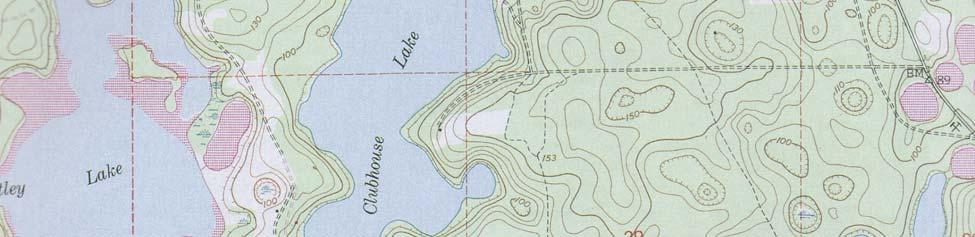
1 Geology 103 Planet Earth (QR II), Laboratory Exercises 1 Student Name: Section: Karst Landform: Groundwater Anyone who has viewed Chinese landscape scroll paintings will recognize that the mountains are very different from those of the Alps or the Rockies. An example of such a Chinese scroll painting is given on the right. It shows that mountains often have very steep, nearly vertical sides with cone-shaped tops, and there are columns after columns of this kind of conical hills. For many years, westerners thought that Chinese painters were unable to portray the landscape accurately. It turns out that this is a very unusual geologic formation called karst towers. They have been made famous by the sceneries in Guilin of southwestern China. Shown below is a recent picture of a village in the area, which has become a very popular tourist attraction. Karst topography is produced by groundwater percolating slowly through the interconnected pores or nearly vertical fractures in the subsurface. Dissolution of soluble rocks around these fractures sometimes produced a bowl-shaped depression at the surface, called a sinkhole. Sinkholes are quite common in Florida or southern Illinois. Sometimes, an underground cavity is hollowed out by the solution process forming spectacular caverns such as those of the Mammoth Cave in Kentucky. The karst towers in Guilin or in Chinese scroll paintings represent undissolved materials, commonly located between intersecting sets of fractures. Limestone formations beneath the surface are especially susceptible to groundwater dissolution. Assignment: 1. Given on the last page of this package is a topographic map of an area in southern Florida. The vertical and horizontal grid lines are 1 mile apart. The contour intervals are 10 feet. Recall that hachures of a contour line indicate the direction of downward slope at the surface. Circle at least three contour lines that show a closed depression at the surface with a red pen (or pencil). What type of rock formation would you guess underlying this area?
 3.")
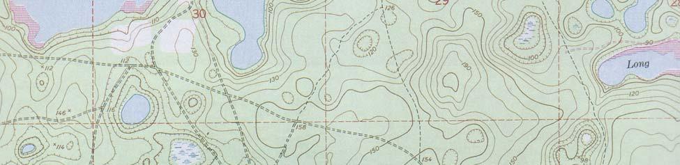
2 Geology 103 Planet Earth (QR II), Laboratory Exercises 2 2. Explain why some depressions (i.e., sinkholes) are filled with water to form ponds and lakes and others are dry. (Hint: assume that the water table in this area is the same everywhere; say at about 85 ft elevation.) 3. If you are to drill a water-well at a location marked by the red cross at the lower right hand corner of the map, explain how deep do you need to drill before you can reach the water table? Groundwater Flows: Groundwater flows from areas with a high hydraulic head to areas with lower hydraulic heads. Hydraulic head is a measure of pressure of the groundwater. Under unconfined conditions (i.e., in the absence of an impermeable layer above the groundwater), heights of the water table are a good measure of local hydraulic heads. Note that water table represents a boundary beneath which all pore spaces are filled with water. Groundwater flows so slowly that it does not replenish itself instantaneously as we are accustom to for surface water. To see how groundwater behaves, go to McDonald s in the Illini Union and order a thick shake. Take the top off, insert a straw, and start enjoy your desert. As soon as you suck up the shake, look at the surface of the liquid in the cup. A small depression forms around the straw because the liquid at the end of the straw has been removed, causing the surface to collapse downward. Groundwater behaves in the same way. The depression is often called the cone of depression. The following diagram illustrates how ground water table form a cone of depression around a well. Because of the depression, ground water flows from higher water table towards the well (which has a lower water table), resulting in the drop of water table in the surrounding area. This can become a major problem in highly populated area, where extensive removal of groundwater can produce a large cone of depression causing local wells to run dry. zone of aeration cone of depression water table pores filled with air and water zone of saturation all pores filled with water
3 Geology 103 Planet Earth (QR II), Laboratory Exercises 3 Assignment: Given on page 5 is a map showing an area here in Central Illinois. Farmer McDonald has lived in this area for years. Throughout these years, his drinking and irrigation needs are all dependent on a well drilled into the unconfined Mahomet aquifer. A few years ago, the county board brought two new industries into the area: the Grandma s Bottle Water Company and the Sandpiper Quarry. Trouble set in when Farmer McDonald discovered that his well had run dry a year after the companies have moved into the area. Having past Geology 103 at this university many years ago, he suspected that the loss of water was due to the increased water use by the new industries, especially the Grandma s Bottle Water Company since it is closer to his farm. He immediately sued Grandma to stop her from using his water. Grandma argued that she had nothing to do with his problem. The judge, knowing nothing about geology, appointed you as an expert to resolve the problem. Your assignment is to find out where Farmer McDonald s water has gone. So far, you have accumulated a lot of data. A quick survey of the area shows that local topography is flat as a pancake. Ground water table (tabulated with respect to the sea-level) has been mapped both before and after the two companies have moved in. The data are tabulated in the table on page 4. It should also be pointed out that Grandma needs to pump groundwater for her product. Although the Sandpiper Quarry does not need to use the water, it needs to pump water out from the pit so that the quarry can remain dry and operational. a) Based on the tabulated data, plot the contour lines of 10 m, 15 m, and 20 m of the water table before the companies began pumping on map A of page 5. Determine and sketch the general direction of groundwater flows in the region. b) Repeat step (a) and plot the contour lines of 25 m, 30 m, 35 m, 40 m, and 45 m of the water table after the companies began pumping on map B of page 5. c) As has been described earlier, groundwater flows from areas with high water table towards areas of lower water table. Flow lines are always perpendicular to contour line. Draw some flow lines on the contour map that you have constructed for (b). Describe how groundwater flows in this area and determine where Farmer McDonald lost his water. d) Groundwater flow velocity is dependent on the hydraulic gradient, which is equivalent to the slope of the water table. The formula to calculate flow velocities is given below. h v = k x Here, v means the absolute value of velocity v (in other words, direction of the flow velocity is ignored in this formula); k is the hydraulic conductivity, which is a material property dependent on rock type of the aquifer; h is the water table difference; and x is the distance between the two stations where the water table difference was measured.
4 Geology 103 Planet Earth (QR II), Laboratory Exercises 4 Based on the contour maps that you have constructed and the scale given for the maps, calculate flow velocities between Farmer McDonald and the two companies both before and after the companies began pumping. Let us assume that typical rock type for the aquifer is glacial tills with a hydraulic conductivity of 1 m/day. Height of water table (w.r.t. sea-level) near McDonald s Farm in meters before companies began pumping after companies began pumping station height station height station height station height
5 Geology 103 Planet Earth (QR II), Laboratory Exercises 5 Location Maps of Measurement Stations around McDonald s Farm A. Before the companies began pumping: Sandpiper Quarry McDonald s 21 Farm Grandma s Bottle Water Co B. After the companies began pumping: Sandpiper Quarry McDonald s 21 Farm Grandma s Bottle Water Co scale in km


6 Geology 103 Planet Earth (QR II), Laboratory Exercises 6
Chapter 14: Groundwater. Fig 14.5b
 Chapter 14: Groundwater Fig 14.5b OBJECTIVES Recognize that groundwater is a vital source of accessible freshwater. Describe how groundwater forms below the water table. Explain the origin of aquifers,
Prof. Stephen A. Nelson EENS 111. Groundwater
 Page 1 of 8 Prof. Stephen A. Nelson EENS 111 Tulane University Physical Geology This page last updated on 20-Oct-2003 is water that exists in the pore spaces and fractures in rock and sediment beneath
What is a water table? What is an aquifer? What is the difference between a spring and a well?
 CHAPTER 11 3 Water Underground SECTION The Flow of Fresh Water BEFORE YOU READ After you read this section, you should be able to answer these questions: What is a water table? What is an aquifer? What
FORENSIC GEOLOGY A CIVIL ACTION
 NAME 89.215 - FORENSIC GEOLOGY A CIVIL ACTION I. Introduction In 1982 a lawsuit was filed on behalf of eight Woburn families by Jan Schlictmann. The suit alleged that serious health effects (childhood
Chapter 13. Groundwater
 Chapter 13 Groundwater Introduction Groundwater is all subsurface water that completely fills the pores and other open spaces in rocks, sediments, and soil. Groundwater is responsible for forming beautiful
Geology 101 Lab Worksheet: Topographic Maps
 Geology 101 Lab Worksheet: Topographic Maps Name: Refer to the Topographic Maps Lab for the information you need to complete this worksheet (http://commons.wvc.edu/rdawes/g101ocl/labs/topomapslab.html).
Modeling the Interconnection between Surface and Groundwater
 Modeling the Interconnection between Surface and Groundwater Andrew Warnock- GetWet, Colorado State University GetWet.Colostate.edu Three Explorations 1. Model two fundamentally different types of streams.
Extra Credit Assignment (Chapters 4, 5, 6, and 10)
") GEOLOGY 306 Laboratory Instructor: TERRY J. BOROUGHS NAME: Extra Credit Assignment (Chapters 4, 5, 6, and 10) For this assignment you will require: a calculator and metric ruler. Chapter 4 Objectives:
GEOLOGY 306 Laboratory Instructor: TERRY J. BOROUGHS NAME: Extra Credit Assignment (Chapters 4, 5, 6, and 10) For this assignment you will require: a calculator and metric ruler. Chapter 4 Objectives:
Essentials of Geology, 11e
 Essentials of Geology, 11e Groundwater Chapter 10 Instructor Jennifer Barson Spokane Falls Community College Geology 101 Stanley Hatfield Southwestern Illinois Co Jennifer Cole Northeastern University
Surface Processes Focus on Mass Wasting (Chapter 10)
") Surface Processes Focus on Mass Wasting (Chapter 10) 1. What is the distinction between weathering, mass wasting, and erosion? 2. What is the controlling force in mass wasting? What force provides resistance?
Surface Processes Focus on Mass Wasting (Chapter 10) 1. What is the distinction between weathering, mass wasting, and erosion? 2. What is the controlling force in mass wasting? What force provides resistance?
6.1 Water. The Water Cycle
 6.1 Water The Water Cycle Water constantly moves among the oceans, the atmosphere, the solid Earth, and the biosphere. This unending circulation of Earth s water supply is the water cycle. The Water Cycle
Prentice Hall EARTH SCIENCE
 Prentice Hall EARTH SCIENCE Tarbuck Lutgens Running Water and Groundwater Running Water The Water Cycle Water constantly moves among the oceans, the atmosphere, the solid Earth, and the biosphere. This
***When doing the lab report write-up, be sure to follow the guidelines.***
 Topographic Maps Lab Vocabulary: topography - study of the shapes and features of the earth's surface elevation - height above sea level bench mark - a point that has been accurately measured for its position
Why Study Groundwater?
 Groundwater Water filling open spaces in rock, sediment, and soil beneath the surface is called groundwater. This natural resource is as important to human endeavors as surface water. Groundwater is an
Groundwater. (x 1000 km 3 /y) Reservoirs. Oceans Cover >70% of Surface. Groundwater and the. Hydrologic Cycle
 Reservoirs. Oceans Cover >70% of Surface. Groundwater and the. Hydrologic Cycle") Chapter 13 Oceans Cover >70% of Surface Groundwater and the Hydrologic Cycle Oceans are only 0.025% of Mass Groundwater Groundwater is liquid water that lies in the subsurface in fractures in rocks and
Chapter 13 Oceans Cover >70% of Surface Groundwater and the Hydrologic Cycle Oceans are only 0.025% of Mass Groundwater Groundwater is liquid water that lies in the subsurface in fractures in rocks and
Hydrogeology of Karst NE Wisconsin. Dr. Maureen A. Muldoon UW-Oshkosh Geology Department
 Hydrogeology of Karst NE Wisconsin Dr. Maureen A. Muldoon UW-Oshkosh Geology Department WI Bedrock Outline Karst Landscapes Existing WQ Data Flow in Karst Aquifers Overview of Silurian Aquifer Water Level
Groundwater. (x 1000 km 3 /y) Oceans Cover >70% of Surface. Groundwater and the. Hydrologic Cycle
 Oceans Cover >70% of Surface. Groundwater and the. Hydrologic Cycle") Chapter 17 Oceans Cover >70% of Surface Groundwater and the Hydrologic Cycle Vasey s Paradise, GCNP Oceans are only 0.025% of Mass Groundwater Groundwater is liquid water that lies in the subsurface in
Chapter 17 Oceans Cover >70% of Surface Groundwater and the Hydrologic Cycle Vasey s Paradise, GCNP Oceans are only 0.025% of Mass Groundwater Groundwater is liquid water that lies in the subsurface in
GEOL.3250 Geology for Engineers Glacial Geology
 GEOL.3250 Geology for Engineers Glacial Geology NAME Part I: Continental Glaciation Continental glaciers are large ice sheets that cover substantial portions of the land area. In the region of accumulation
1 Water Beneath the Surface
 CHAPTER 16 1 Water Beneath the Surface SECTION Groundwater KEY IDEAS As you read this section, keep these questions in mind: What are two properties of aquifers? How is the water table related to the land
The Niagara Escarpment extends from western New York, through the GTA all the way up to Manitoulin Island and into Michigan and Wisconsin.
 is southern Ontario s most prominent topographic feature, extending more than 500 kilometres from western New York, through Niagara Falls and the western part of the Greater Toronto Area (GTA), and north
Lecture 15: Subsidence
 Lecture 15: Subsidence Key Questions 1. How does removal of groundwater cause subsidence on a regional scale? 2. Under what conditions does a building sink into sediment? 3. Why do clays consolidate more
Florida s Karst Geology
 Florida s Karst Geology Orange Creek Basin Interagency Working Group Public Workshop, November 5 th, 2015 Harley Means, P.G. Assistant State Geologist Florida Geological Survey Karst Karst a type of topography
Karst found mostly in limestone (rock with at least 50% carbonate minerals), depends on 1) permeability & porosity
, depends on 1) permeability & porosity") KARST LANDFORMS produced by weathering & erosion in regions of carbonate rocks and evaporites processes called karstification mainly below ground surface predominantly underground drainage poorly-developed
KARST LANDFORMS produced by weathering & erosion in regions of carbonate rocks and evaporites processes called karstification mainly below ground surface predominantly underground drainage poorly-developed
Groundwater. Earth Chapter 17
 Groundwater Earth Chapter 17 Chapter 17 Groundwater Importance of Groundwater Groundwater is water found in the pores of soil and sediment, plus narrow fractures in bedrock Groundwater and the Hydrosphere
Topographic Maps Knowledge of Maps What are they? What are they used for? Why are they important?
 Topographic Maps Knowledge of Maps What are they? What are they used for? Why are they important? Topographic Maps Maps that show the change in elevation of land. Elevation is the height of land above
WATER ON AND UNDER GROUND. Objectives. The Hydrologic Cycle
 WATER ON AND UNDER GROUND Objectives Define and describe the hydrologic cycle. Identify the basic characteristics of streams. Define drainage basin. Describe how floods occur and what factors may make
Soils, Hydrogeology, and Aquifer Properties. Philip B. Bedient 2006 Rice University
 Soils, Hydrogeology, and Aquifer Properties Philip B. Bedient 2006 Rice University Charbeneau, 2000. Basin Hydrologic Cycle Global Water Supply Distribution 3% of earth s water is fresh - 97% oceans 1%
STUDY GUIDE FOR CONTENT MASTERY. Movement and Storage of Groundwater
 Groundwater SECTION 10.1 Movement and Storage of Groundwater In your textbook, read about the hydrosphere, precipitation and groundwater, and groundwater storage. Use the following terms to complete the
RIVERS, GROUNDWATER, AND GLACIERS
 RIVERS, GROUNDWATER, AND GLACIERS Delta A fan-shaped deposit that forms when a river flows into a quiet or large body of water, such as a lake, an ocean, or an inland sea. Alluvial Fan A sloping triangle
Subsidence is the sinking or collapse of a portion of the land surface. The movement involved in subsidence is essentially vertical; little or no
 1 Subsidence is the sinking or collapse of a portion of the land surface. The movement involved in subsidence is essentially vertical; little or no horizontal motion is involved. It may take the form of
Land Subsidence. Land subsidence is defined as the lowering of the land surface.
 Land Subsidence Land subsidence is defined as the lowering of the land surface. Many different factors can cause the land surface to subside. Subsidence can occur rapidly due to: a sinkhole or under ground
Karst Topography In order to understand karst topography we must first have a basic understanding of the water cycle, the formation of limestone (carb
 Karst Topography The formation of caves and other associated features in limestone bedrock is called karst topography. Limestone, a sedimentary rock made mostly of the mineral calcite and small amounts
The Favorability of Florida s Geology to Sinkhole Formation
 Florida Geological Survey The Favorability of Florida s Geology to Sinkhole Formation Clint Kromhout Alan Baker October 24, 2017 Subsidence Report Database Map of Subsidence Incident Reports taken from
Guided Notes Topographic Maps
 Guided Notes Topographic Maps Map scale Straight line distance Curved line distance Rules of Isolines Contour Lines Hachured Lines Possible elevations Slope & Gradient Direction of River Flow Topographic
Lecture Outlines PowerPoint. Chapter 5 Earth Science 11e Tarbuck/Lutgens
 Lecture Outlines PowerPoint Chapter 5 Earth Science 11e Tarbuck/Lutgens 2006 Pearson Prentice Hall This work is protected by United States copyright laws and is provided solely for the use of instructors
 12 10 8 6 4 2 0 40-50 50-60 60-70 70-80 80-90 90-100 Fresh Water What we will cover The Hydrologic Cycle River systems Floods Groundwater Caves and Karst Topography Hot springs Distribution of water in
EARTH SCIENCE 11 CHAPTER 9 NOTES WATER MOVING UNDERGROUND
 EARTH SCIENCE 11 CHAPTER 9 NOTES WATER MOVING UNDERGROUND KEY A. ALL THE WORLD S WATER 1. The world has an estimated one and one third thousand million cubic kilometers of water. 2. The earth s water is
Wisconsin s Hydrogeology: an overview
 2012 Soil and Water Conservation Society Conference Stevens Point, WI Feb 9, 2012 Wisconsin s Hydrogeology: an overview Ken Bradbury Wisconsin Geological and Natural History Survey University of Wisconsin-Extension
EROSIONAL FEATURES. reflect
 reflect Have you ever looked at the land around you and wondered what processes shaped what you see? Perhaps you see mountains, valleys, rivers, or canyons. Do you know how long these geologic features
Erosional Features. What processes shaped this landscape?
 Have you ever looked at the land around you and wondered what processes shaped what you see? Perhaps you see mountains, valleys, rivers, or canyons. Do you know how long these geologic features have been
Modeling Anchialine Pools
 Modeling Anchialine Pools Andrew Warnock- GetWet, Colorado State University GetWet.Colostate.edu Two Explorations 1. We will model an anchialine pool in both map view and cross section. 2. We will simulate
Chapter 14. Groundwater
 Chapter 14 Groundwater Importance of groundwater! Groundwater is water found in the pores of soil and sediment, plus narrow fractures in bedrock! Groundwater is the largest reservoir of fresh water that
Groundwater Hydrology
 EXERCISE 12 Groundwater Hydrology INTRODUCTION Groundwater is an important component of the hydrologic cycle. It feeds lakes, rivers, wetlands, and reservoirs; it supplies water for domestic, municipal,
Directed Reading. Section: Types of Maps
 Skills Worksheet Directed Reading Section: Types of Maps 1. What are some of the characteristics of an area shown on maps used by Earth scientists? a. types of animals, types of plants, types of minerals
What can they teach each other? Geary M. Schindel, P.G. Chief Technical Officer Edwards Aquifer Authority San Antonio, Texas
 Cavers and Geologists What can they teach each other? Geary M. Schindel, P.G. Chief Technical Officer Edwards Aquifer Authority San Antonio, Texas Karst is a landscape where dissolution is the dominant
GEOL 3700 STRUCTURE AND TECTONICS LABORATORY EXERCISE 3
 GEOL 3700 STRUCTURE AND TECTONICS LABORATORY EXERCISE 3 Goals: 1. Improve your map-reading and map-making skills. 2. Learn to generate and interpret structure contour maps. 3. Learn to generate and interpret
Topographic Maps. More than a Road Map
 Topographic Maps More than a Road Map What is a Topographic Map? Scaled representation of features on the surface of the Earth such as roads, rivers, and plains Provides information about land elevations
1. The topographic map below shows a depression contour line on Earth's surface.
 1. The topographic map below shows a depression contour line on Earth's surface. Points A, B, C, and D represent surface locations. Contour line elevations are in feet. Which profile best shows the topography
Regents Earth Science Unit 1 Earth Dimensions
 Regents Earth Science Unit 1 Earth Dimensions www. BarnesWeb.org 2014-15 edition Name: Name: OBJECTIVES Correctly define: isolines, gradient, topographic map, contour interval, hachured lines, profile,
Welcome to. Who Wants to be a Millionaire 50:50
 0:0 Welcome to Who Wants to be a Millionaire 0 $ Million,000 $,000 $00 Selecting the lucky competitor Rules: We will do this in quarterfinals, semifinals, and final round. So I need volunteers. Face away
3/15/17. #22 - Subsidence - Rapid Sinkhole at Winter Park, FL in Rapid Subsidence Defined and Illustrated
 Web Exercise #3 (Volcanoes) Late- closing at 1:00 today Web Exercise #4 (Landslides) DUE WEDNESDAY Use Hazard City to answer matching question in Part II #22 - Subsidence - Rapid Sinkhole at Winter Park,
MAPPING THE EARTH HOW DO YOU FIND A LOCATION ON THE EARTH?
 MAPPING THE EARTH HOW DO YOU FIND A LOCATION ON THE EARTH? UNIT TOPICS TOPIC 1: LATITUDE & LONGITUDE TOPIC 2: FIELD MAPS TOPIC 3: TOPOGRAPHIC MAPS TOPIC 4: NYS LANDSCAPES TOPIC 1: LATITUDE & LONGITUDE
LBJWC - Sinkhole Lesson
 LBJWC - Sinkhole Lesson Concept Caves and sinkholes are major openings in the ground that recharge water to the Edwards Aquifer. Objective - Students will: 1) identify a sinkhole, cave, fracture, fault,
EMERGENCY INVESTIGATION OF EXTREMELY LARGE SINKHOLES, MAOHE, GUANGXI, CHINA
 EMERGENCY INVESTIGATION OF EXTREMELY LARGE SINKHOLES, MAOHE, GUANGXI, CHINA Mingtang Lei, Xiaozhen Jiang, Zhende Guan Institute of Karst Geology, CAGS, Guilin, China, mingtanglei@hotmail.com Yongli Gao
APPENDIX A GLOSSARY. Appendix A.1
 APPENDIX A GLOSSARY Appendix A.1 Appendix A.2 Back Bearing A back bearing is measured from the object to your position. It is the exact opposite of a direct bearing. Base Line An imaginary line on the
STUDY GUIDE FOR MID-TERM EXAM KEY. Color, luster, cleavage, fracture, hardness, taste, smell, fluorescence, radioactivity, magnetism
 STUDY GUIDE FOR MID-TERM EXAM KEY 1. In which type of rock are fossils most likely to be found? Sedimentary Rocks 2. Which mineral is easily identified by smell? Sulfur 3. Which natural resource makes
KARST MAPPING WITH GEOPHYSICS AT MYSTERY CAVE STATE PARK, MINNESOTA
 KARST MAPPING WITH GEOPHYSICS AT MYSTERY CAVE STATE PARK, MINNESOTA By Todd A. Petersen and James A. Berg Geophysics Program Ground Water and Climatology Section DNR Waters June 2001 1.0 Summary A new
GEOL 110. Sedimentary Layering. Geologic Structures (faults, joints, folds), Unconformities, Karst. Sedimentary Layering 9/23/17. Geologic Structures
, Unconformities, Karst. Sedimentary Layering 9/23/17. Geologic Structures") GEOL 110 Sedimentary Layering Geologic Structures (faults, joints, folds), Unconformities, Karst Layering = horizontal, continuous banding produced during sediment deposition Sedimentary Layering Geologic
GEOL 110 Sedimentary Layering Geologic Structures (faults, joints, folds), Unconformities, Karst Layering = horizontal, continuous banding produced during sediment deposition Sedimentary Layering Geologic
Lab 9: Petroleum and groundwater
 Geology 101 Name(s): Lab 9: Petroleum and groundwater Petroleum (oil) is a multi-component liquid refined to generate different hydrocarbons, such as heptane (a component of gasoline) and waxes. For the
MAPPING BEDROCK: Verifying Depth to Bedrock in Calumet County using Seismic Refraction
 MAPPING BEDROCK: Verifying Depth to Bedrock in Calumet County using Seismic Refraction Revised December 13, 2011 Dave Hart Wisconsin Geological and Natural History Survey INTRODUCTION Seismic refraction
Erosion and Deposition
 Erosion and Deposition Erosion Sediment natural forces move rock/soil from one place to another. gravity, water, wind, glaciers, waves are causes material moved by erosion Deposition when erosion lays
Section 3. Slopes and Landscapes. What Do You See? Think About It. Investigate. Learning Outcomes
 Chapter 4 Surface Processes Section 3 Slopes and Landscapes What Do You See? Learning Outcomes In this section, you will Calculate the angle of repose for different kinds of soils and other granular materials.
Lab Topographic Maps. Name: Partner: Purpose. Background Information
 Lab Topographic Maps Name: Partner: Purpose The purpose of this lab is to familiarize you with graphic representations of the Earth s surface primarily maps. Simple line maps show the spatial relationship
Module 10: Resources and Virginia Geology Topic 4 Content: Virginia Geology Notes
 Virginia is composed of a very diverse landscape that extends from the beaches and barrier islands all of the way to the highly elevated Appalachian Plateau. Geologists have discovered ancient shallow
11. ALPINE GLACIAL LANDFORMS
 Geomorphology 11. Alpine Glacial Landforms 11. ALPINE GLACIAL LANDFORMS 40 Points One objective of this exercise is for you be able to identify alpine glacial landforms and measure their characteristics.
Mapping Earth. How are Earth s surface features measured and modeled?
 Name Mapping Earth How are Earth s surface features measured and modeled? Before You Read Before you read the chapter, think about what you know about maps Record your thoughts in the first column Pair
Mammoth Cave National Park, Kentucky
 Mammoth Cave National Park, Kentucky Objectives of Today s Lecture Refresher on Sedimentary Depositional Systems and Rock Classifications Transgressive and Regressive Marine Environments Carbonate Depositional
Notes and Summary pages:
 Topographic Mapping 8.9C Interpret topographical maps and satellite views to identify land and erosional features and predict how these shapes may be reshaped by weathering ATL Skills: Communication taking
Examining the Terrestrial Planets (Chapter 20)
") GEOLOGY 306 Laboratory Instructor: TERRY J. BOROUGHS NAME: Examining the Terrestrial Planets (Chapter 20) For this assignment you will require: a calculator, colored pencils, a metric ruler, and your geology
GEOLOGY 306 Laboratory Instructor: TERRY J. BOROUGHS NAME: Examining the Terrestrial Planets (Chapter 20) For this assignment you will require: a calculator, colored pencils, a metric ruler, and your geology
Tuesday, September 05, 2017 Planet Earth
 Tuesday, September 05, 2017 Planet Earth Objective: Describe the solar system and Earth s location in it. Identify Earth s shape. Discuss Earth s structure. List Earth s landforms Do Now: What is a compass
SINKHOLES WHERE AND WHY THEY FORM
 SINKHOLES WHERE AND WHY THEY FORM In the wake of the sinkhole that developed beneath a Florida man s bedroom, tragically killing the man as he was sucked into the earth, many people are searching for information.
Topographic Maps and Profiles
 Name: Date: Period: Earth Science Foundations The Physical Setting: Earth Science CLASS NOTES! Topographic Maps [contour maps] -! Topographic maps show three-dimensional shapes in two dimensions Elevation
Karst Landforms. Caverns Sinkholes Disappearing Streams Springs Towers
 Karst Landforms Karst is a term used to describe landscapes that are formed by chemical weathering process controlled by groundwater activity. Karst landscapes are predominantly composed of limestone rock
One Hilltop, Three Major Watersheds!
 One Hilltop, Three Major Watersheds! Adapted from: An original Creek Connections activity. Creek Connections, Box E, Allegheny College, Meadville, Pennsylvania, 16335 Watersheds of PA/ Topo Map Review
It usually refers to limestone terrain characteristically. possessing a patchy and thin soil cover, containing many enclosed depressions, and
 Karst Landform karst is terrain in which soluble rocks are altered above and below ground by the dissolving action of water and that bears distinctive characteristics of relief and drainage (Jennings 1971,)
Geophysical Methods for Screening and Investigating Utility Waste Landfill Sites in Karst Terrain
 Geophysical Methods for Screening and Investigating Utility Waste Landfill Sites in Karst Terrain Gary Pendergrass, PE, RG, F.NSPE Principal Geological Engineer Kansas City Geotechnical Conference 2017
 Chapter 2 Mapping Our World Picture: Mount Capulin, Raton, NM Cinder Cone Volcano ://3.bp.blogspot.com/_sKz1KwXRzcg/SzFzM52gIoI/AAAAAAAAABk/hguBAT80pk0/s320/capulin.jpg http://www.peteandmelissa.com/images/oklahoma/p1020190.jpg
Class Notes: Mapping the Earth
 Name: Date: Period: Mapping the Earth The Physical Setting: Earth Science Class Notes: Mapping the Earth I. Latitude and Longitude Map -! Latitude -! Also called These lines intersect Equator -! The North
11/22/2010. Groundwater in Unconsolidated Deposits. Alluvial (fluvial) deposits. - consist of gravel, sand, silt and clay
 deposits. - consist of gravel, sand, silt and clay") Groundwater in Unconsolidated Deposits Alluvial (fluvial) deposits - consist of gravel, sand, silt and clay - laid down by physical processes in rivers and flood plains - major sources for water supplies
Groundwater in Unconsolidated Deposits Alluvial (fluvial) deposits - consist of gravel, sand, silt and clay - laid down by physical processes in rivers and flood plains - major sources for water supplies
Senior Thesis. BY Calliope A. Voiklis 2000
 Senior Thesis MODFLOW Model of The Ohio State University, Columbus Campus BY Calliope A. Voiklis 2000 Submitted as partial fulfillment of The requirements of the degree of Bachelor of Science in Geological
Groundwater Quality. Landform Development by Subsurface Water. Karst Landscapes and Landforms
 LANDFORM DEVELOPMENT BY SUBSURFACE WATER 447 320 kilometers (200 mi) away (see again Fig. 16.8). Other wellknown artesian systems are found in Olympia, Washington; the western Sahara; and eastern Australia
SINKHOLE SUSCEPTIBILITY ANALYSIS FOR KARAPINAR/KONYA VIA MULTI CRITERIA DECISION
 SINKHOLE SUSCEPTIBILITY ANALYSIS FOR KARAPINAR/KONYA VIA MULTI CRITERIA DECISION F.Sarı a a SU, Cumra School of Applied Sciences, Konya, Turkey fatihsari@selcuk.edu.tr KEY WORDS: Multi Decision Criteria,
Structural Geology Lab. The Objectives are to gain experience
 Geology 2 Structural Geology Lab The Objectives are to gain experience 1. Drawing cross sections from information given on geologic maps. 2. Recognizing folds and naming their parts on stereoscopic air
Chapter 3 SECTION 1 OBJECTIVES
 Chapter 3 SECTION 1 OBJECTIVES Distinguish between latitude and longitude and locate coordinates on maps. Explain how latitude and longitude can be used to locate places on Earth s surface. Explain the
Geology 101, Spring 2008
 Geology 101, Spring 2008 Name(s): Lab 10: Groundwater and resource extraction Groundwater As many parts of the world are becoming increasingly aware, groundwater is an economic resource, as strategic and
Name: Mid-Year Review #2 SAR
 Name: Mid-Year Review #2 SAR Base your answers to questions 1 through 3 on on the diagram below, which shows laboratory materials used for an investigation of the effects of sediment size on permeability,
Glacial Deposition and Groundwater in Dutchess County
 Glacial Deposition and Groundwater in Dutchess County Name: Period: Thousands of years ago an enormous ice sheet blanketed the Hudson Valley in what was called the Wisconsinan Glaciation. The ice reshaped
KARST LANDSCAPES Geology & Hydrology. Dr. Gerald E. Weber
 KARST LANDSCAPES Geology & Hydrology Dr. Gerald E. Weber Aerial Oblique Photograph of the UCSC Campus looking northwest Karst A type of topography that is formed on limestone, gypsum, and other soluble
Introduction to Contour Maps
 Your web browser (Safari 7) is out of date. For more security, comfort and Activityengage the best experience on this site: Update your browser Ignore Introduction to Contour Maps What information does
Development of geophysical investigation for verifying treatment efficiency of underground cavities
 Development of geophysical investigation for verifying treatment efficiency of underground cavities Hasan A. Kamal* Kuwait Institute for Scientific Research, Infrastructure Risk and Reliability Program,
Weathering, Mass Wasting and Karst
 Weathering, Mass Wasting and Karst Capable of wearing down anything that the internal processes can build. Gravity, water, wind and ice Denudation - the overall effect of disintegration, wearing away and
Laboratory Exercise #2 Introduction to Quadrangle Maps
 page - 1 Laboratory Exercise #2 Introduction to Quadrangle Maps A. Introduction to Quadrangle Maps The United States Geological Survey has developed a nationwide series of quadrangle maps that cover small
Latitude and Longitude
 U n i t 3 M a p p i n g P a g e 1 Latitude and Longitude Note: These coordinates are always expressed LATITUDE/LONGITUDE!!! Coordinate System: Using and to find your position on Earth. LATITUDE LATITUDE
There's Too Much Tension
 There's Too Much Tension Once you find the geocache, click "Found It" on the Geocaching.com app and then read and answer the questions below. Make sure to return the cache to exactly the same place you
Structural Geology Lab. The Objectives are to gain experience
 Geology 2 Structural Geology Lab The Objectives are to gain experience 1. Drawing cross sections from information given on geologic maps. 2. Recognizing folds and naming their parts on stereoscopic air
Reservoirs and Production
 Lesson Plan - Page 1 Topic Reservoirs and Production Source Oil and Natural Gas, pages 24-25, 26-27 Objective The students will learn that porosity refers to the percentage of holes (pores) in the rock.
Example Quiz on Earthquakes
 Example Quizzes, Tests, and Review Information A Example Quiz on Earthquakes Quizzes such as this one are given at the beginning of each lab. 1. The point beneath the Earth s surface at which an earthquake
1.72, Groundwater Hydrology Prof. Charles Harvey Lecture Packet #5: Groundwater Flow Patterns. Local Flow System. Intermediate Flow System
 1.72, Groundwater Hydrology Prof. Charles Harvey Lecture Packet #5: Groundwater Flow Patterns c Local Flow System 10,000 feet Intermediate Flow System Regional Flow System 20,000 feet Hydrologic section
There's Too Much Tension
 There's Too Much Tension Once you find the geocache, click "Found It" on the Geocaching.com app and then read and answer the questions below. Make sure to return the cache to exactly the same place you
Laboratory Exercise #2 Introduction to Quadrangle Maps
 page - Laboratory Exercise #2 Introduction to Quadrangle Maps A. Introduction to Quadrangle Maps The United States Geological Survey has developed a nationwide series of quadrangle maps that cover small