VII. Cities and Urban Land Use
|
|
|
- Ezra O’Connor’
- 5 years ago
- Views:
Transcription
1 VII. Cities and Urban Land Use Tuesday, May 2, :13 AM Enduring Understandings Learning Objectives Essential Knowledge A. The form, function, and size of urban settlements are constantly changing Explain the factors that initiate and drive urbanization and suburbanization Site and situation influence the origin, function, and growth of cities Transportation and communication have facilitated urbanization (e.g., Borchert s epochs of urban growth) and suburbanization Improvements in agriculture and transportation, population growth, migration, economic development, and government policies influence urbanization World cities function at the top of the world s urban hierarchy and drive globalization Megacities are rapidly increasing in countries of the periphery and semiperiphery B. Models help to understand the distribution and size of cities Apply models to explain the hierarchy and interaction patterns of urban settlements Megacities and world cities experience economic, social, political, and environmental challenges Models that are useful for explaining the distribution and size of cities include the rank-size rule, the law of the primate city, and Christaller s central place theory The gravity model is useful in explaining interactions among networks of cities C. Models of internal city structure and urban development provide a framework for urban analysis Explain the models of internal city structure and urban development Classic models that are useful for explaining the internal structures of cities and urban development are the Burgess concentric-zone model, the Hoyt sector model, and the Harris Ullman multiple-nuclei model The galactic city model is useful for explaining internal structures and urban development within metropolitan areas D. Built landscapes and social space reflect the attitudes and values of a population Analyze residential land use in terms of low-, medium-, and high-density housing Evaluate the infrastructure of cities Explain the planning and design issues and political organization of urban areas World-regional models (e.g., Latin America, Africa) are useful (with limitations) for explaining land use and urban development Residential buildings and patterns of land use reflect a city s culture, technological capabilities, and cycles of development Economic development and interconnection within a metropolitan area are dependent upon the location and quality of infrastructure (e.g., public transportation, airports, roads, communication systems, water and sewer systems) Sustainable design initiatives include walkable mixed-use commercial and residential areas and smart-growth policies (e.g., new urbanism, greenbelts, slow-growth cities) Functional and geographic fragmentation of governments presents challenges in addressing urban issues Unit 7 Urban Page 1
2 Analyze the demographic composition and population characteristics of cities using quantitative and qualitative data Quantitative information about a city s population is provided by census and survey data E. Urban areas face economic, social, political, cultural, and environmental challenges Evaluate problems and solutions associated with growth and decline within urban areas Evaluate problems associated with urban sustainability Qualitative data from field studies and narratives provide information about individual attitudes toward urban change Economic and social problems associated with the growth and decline of urban communities include housing and insurance discrimination, housing affordability, access to food stores and public services, disamenity zones, zones of abandonment, and gentrification Land use and environmental problems associated with the growth and decline of urban communities include suburban sprawl, sanitation, air and water quality, remediation and redevelopment of brown fields, farmland protection, and energy use From < Unit 7 Urban Page 2

3 Urban Revolutions Friday, May 5, :22 AM The 1st urban Revolution is the Neolithic Revolution from World History I!!! Unit 7 Urban Page 3


4 The History of Urbanization, 3700 BC AD Google Timelapse: Urban Explosion TIME Unit 7 Urban Page 4

5 Unit 7 Urban Page 5

6 Urban Hierarchy Friday, May 5, :23 AM The hierarchy is based on the amount of services available in each place. Unit 7 Urban Page 6
7 Unit 7 Urban Page 7

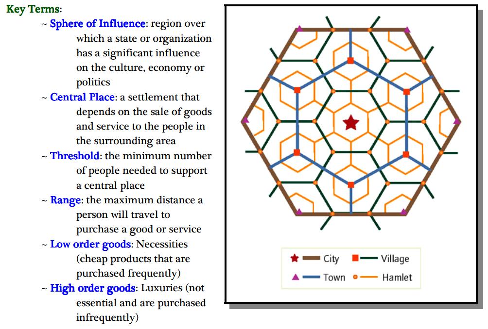
8 Central Place Theory Friday, May 5, :26 AM Central Place Theory Definition: A theory that explains the distribution of services, based on the fact that settlements serve as centers of market areas for services; larger settlements are fewer and farther apart than smaller settlements and provide services for a larger number of people who are willing to travel farther. It was formulated by Walter Christaller in the early 1900s that explains the size and distribution of cities in terms of a competitive supply of goods and services to dispersed populations Assumptions: *people will buy goods from the closest possible place *high demand for a good will cause the good to be offered close to the population *looks at the world as an isotropic plane *soil will be the same everywhere *population and purchasing power will be uniform *there is uniform transportation From < Unit 7 Urban Page 8

9 Unit 7 Urban Page 9

10 Unit 7 Urban Page 10

11 Rank Size Rule vs. Primate Cities Friday, May 5, :29 AM Rank Size Rule Definition: A pattern of settlements in a country, such that the nth largest settlement is 1/n the population of the largest settlement. Most developed nations follow this rule unless they have a primate city. Theoretically there should be more small settlements than large. Example: Largest City: 12 Million People 2nd Largest: 12 million people divide by 2 = 6 million 3rd Largest:12 million people divide by 3 = 4 million 4th Largest: 12 million people divide by 4 = 3 million 5th Largest: 12 million people divide by 5 = 2.4 million From < Unit 7 Urban Page 11

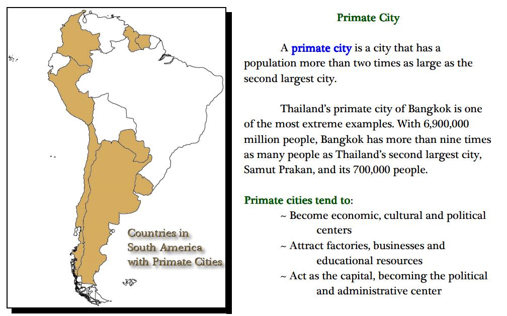
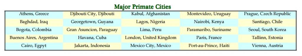
12 Primate City Definition: The largest settlement in a country, must have MORE than 2x the people than the second ranking city. It should be disproportionately large and a leader in national capacity and expressions. Good Examples: Paris, London, Cairo Unit 7 Urban Page 12

13 Unit 7 Urban Page 13

14 Mexico City's Urban Sprawl From < Unit 7 Urban Page 14

15 Gentrification Friday, May 5, :31 AM Unit 7 Urban Page 15


16 A Short Documentary on Gentrification The Pros And Cons Of Gentrification Unit 7 Urban Page 16

17 North American City Models Friday, May 5, :33 AM Unit 7 Urban Page 17

18 Unit 7 Urban Page 18


19 Griffin Ford Latin American Model Friday, May 5, :36 AM Brazil - Rio de Janeiro - Favela Rocinha HD Unit 7 Urban Page 19

20 Sub Saharan Model Friday, May 5, :38 AM Unit 7 Urban Page 20

21 Southeast Asian Model Friday, May 5, :40 AM Unit 7 Urban Page 21

22 Mega and World Cities Friday, May 5, :40 AM A megacity is defined by the United Nations as a metropolitan area with a total population of more than 10 million people. From < The Megacities Of 2050 Unit 7 Urban Page 22


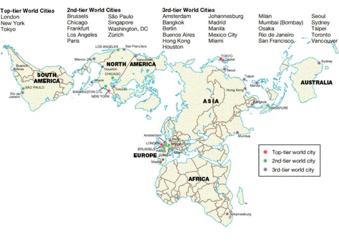
23 Megacities Reflect Growing Urbanization Trend world city: dominant city in terms of its role in the global political economy. Not the world's biggest city in terms of population or industrial output, but rather centers of strategic control of the world economy Unit 7 Urban Page 23
24 From < Unit 7 Urban Page 24

25 Urban Problems Friday, May 5, :47 AM Unit 7 Urban Page 25

26 What is A Food Desert? Unit 7 Urban Page 26


27 Cities around the World Friday, May 5, :49 AM Unit 7 Urban Page 27

28 Unit 7 Urban Page 28

29 Moving Out Friday, May 5, :57 AM Unit 7 Urban Page 29

30 Unit 7 Urban Page 30
31 Vocabulary Friday, May 5, :45 AM trade area rank-size rule central place theory Sunbelt phenomenon functional zonation zone central business district central city suburb suburbanization concentric zone model edge cities urban realm Griffin-Ford model disamenity sector McGee model shantytowns zoning laws an adjacent region within which a city's influence is dominant holds that in a model urban hierarchy, the population of a city or town will be inversely proportional to its rank in the hierarchy theory proposed by Walter Christaller that explains how and where central places in the urban hierarchy should be functionally and spatially distributed with respect to one another the movement of millions of Americans from northern and northeastern States to the South and Southwest regions (Sunbelt) of the United States the division of a city into different regions or zones (e.g. residential or industrial) for certain purposes or functions (e.g. housing or manufacturing) areas with relatively uniform land use, for example, an industrial zone or a residential zone a concentration of business and commerce in the city's downtown the urban area that is not suburban an outlying, functionally uniform part of an urban area, and is often (but not always) adjacent to the central city. the process by which lands that were previously outside of the urban environment become urbanized, as people and businesses from the city move to these spaces CBD-(Burgess Model) divides the city into five concentric zones, defined by their function a term introduced by American journalist Joel Garreau in order to describe the shifting focus of urbanization in the United States away from the Central Business District (CBD) toward a new loci of economic activity at the urban fringe a spatial generalization of the large, late-twentieth-century city in the United States. It is shown to be a widely dispersed, multicentered metropolis consisting of increasingly independent zones or realms, each focused on its own suburban downtown; the only exception is the shrunken central realm, which is focused on the CBD a model of the Latin American city showing a blend of traditional elements of Latin American culture with the forces of globalization that are reshaping the urban scene the very poorest of cities that in extreme cases are not even connected to regular city services and are controlled by gangs or drug-lords developed by geographer T.G. McGee, a model showing similar land-use patterns among the medium-sized cities of Southeast Asia Unplanned slum development on the margins of cities, dominated by crude dwellings and shelters made mostly of scrap wood, iron, and even pieces of cardboard Legal restrictions on land use that determines what types of building and economic activities are allowed to take place in certain areas. In the United States, areas are most commonly divided into separate zones of residential, retail, or industrial use. Unit 7 Urban Page 31
32 retail, or industrial use. redlining a discriminatory real estate practice in North America in which members of minority groups are prevented from obtaining money to purchase homes or property in predominantly white neighborhoods. The practice derived its name from the red lines depicted on cadastral maps used by real estate agents and developers. Today, redlining is officially illegal. blockbusting rapid change in the racial composition of residential blocks in American cities that occurs when real estate agents and others stir up fears of neighborhood decline after encouraging people of color to move to previously white neighborhoods. In the resulting outmigration, real estate agents profit through the turnover of properties commercialization the transformation of an area of a city into an area attractive to residents and tourists alike in terms of economic activity. gentrification the rehabilitation of deteriorated, often abandoned, housing of low-income inner-city residents. tear-downs Home bought in many American suburbs with the intent of tearing them down and replacing them with much larger homes often referred to as McMansions McMansions Homes referred to as such because of their "super size" and similarly in appearance to other such homes, homes often built in place of tear-downs in American suburbs. urban sprawl unrestricted growth in many American urban areas of housing, commercial development, and roads over large expanses of land, with little concern for urban planning new urbanism outlined by a group of architects, urban planners, and developers from over 20 countries, and urban design that calls for development, urban revitalization, and suburban reforms that create walkable neighborhoods with a diversity of housing and jobs. gated communities restricted neighborhoods or subdivisions, often literally fenced in, where entry is limited to residents and their guests. Although predominantly highincome based, in North America gated communities are increasingly a middle-class phenomenon. informal economy economic activity that is neither taxed nor monitored by a government; and is not included in that government's Gross National Product (GNP); as opposed to a formal economy. world city dominant city in terms of its role in the global political economy. Not the world's biggest city in terms of population or industrial output, but rather centers of strategic control of the world economy. primate city a country's largest city-ranking atop the urban hierarchy-most expressive of the national culture and usually (but not always) he capital city as well spaces of consumption areas of a city, the main purpose of which is to encourage people to consume goods and services, driven primarily by the global media industry Annexation Legally adding land area to a city in the United States. Barriadas Squatter settlements found in the periphery of Latin American cities. Census tract An area delineated by the U.S. Bureau of the Census for which statistics are published; in urbanized areas, census tracts correspond roughly to neighborhoods. Central business district The area of a city where retail and office activities are clustered. Unit 7 Urban Page 32
33 Central business district (CBD) Centrality Centralization City Cityscapes Combined statistical area (CSA) Commercialization Commuter zone Concentric zone model Core based statistical area (CBSA) Council of government Decentralization Density gradient Edge city Emerging cities Ethnic neighborhood Favela Filtering Food desert Gateway city Gentrification Great cities Greenbelt In-filling Inner city The area of a city where retail and office activities are clustered. The strength of an urban center in its capacity to attract producers and consumers to its facilities; a city's "reach" into the surrounding region. The movement of people, capital, services, and government into the central city. An urban settlement that has been legally incorporated into an independent, self-governing unit. Similar to a landscape, but used to refer to that of a large urban area. In the United States, two or more contiguous core-based statistical areas tied together by commuting patterns. The transformation of an area of a city into an area attractive to residents and tourists alike in terms of economic activity. Outermost zone of the concentric zone model that represents people who choose to live in residential suburbs and drive into the Central Business District to work each day. A model of the internal structure of cities in which social groups are spatially arranged in a series of rings. In the United States, the combination of all metropolitan statistical areas and micropolitan statistical areas. A cooperative agency consisting of representatives of local governments in a metropolitan area in the United States. The process of dispersing decision-making outwards from the center of authority. The change in density in an urban area from the center to the periphery. A large node of office and retail activities on the edge of an urban area. City currently not having a significant population but increasing in size at a fast rate. Neighborhood, typically situated in a larger metropolitan city and constructed by or comprised of a local culture, in which a local culture can practice its customs. A shantytown or slum, especially in Brazil. A process of change in the use of a house, from single-family owner occupancy to abandonment. An area in a developed country where healthy food is difficult to obtain. A settlement which acts as a link between two areas. A process of converting an urban neighborhood from a predominantly lowincome renter-occupied area to a predominantly middle-class owneroccupied area. Cities with populations over one million. A ring of land maintained as parks, agriculture, or other types of open space to limit the sprawl of an urban area. Building on empty parcels of land within a checkerboard pattern of development. Central area of a major city; often applied to poorer parts of a US city center. Unit 7 Urban Page 33
34 Invasion and succession Process by which new immigrants to a city move to dominate or take over areas or neighborhoods occupied by older immigrant groups. Lateral commuting Traveling from one suburb to another suburb to work. Megacities Cities with more than 10 million people. Megalopolis/conurbation Term used to designate large coalescing supercities that are forming in diverse parts of the world. Metropolitan statistical area Micropolitan statistical area Multiple nuclei model Office park Peak land value intersection Peripheral model Planned communities Postindustrial city Postmodern urban landscape Primary census statistical area (PCSA) Public housing Racial steering Redlining Restrictive covenants Rush (or peak) hour Sector model Segregation Slum Smart growth Social area analysis In the U.S., a central city of at least 50,000 population, the county within the city is located, and adjacent counties meeting of several tests indicating a functional connection to the central city. An urbanized area of between 10,000 and 50,000 inhabitants, the county in which it is found, and adjacent counties tied to the city. A model of the internal structure of cities in which social groups are arranged around a collection of nodes of activities. Agglomeration of office buildings with facilities established for infrastructure to enhance the possibility of business success. The area with the greatest land value and commercial trade. A model of North American urban areas consisting of an inner city surrounded by large suburban residential and business areas tied together by a beltway or ring road. A city, town, or community that was designed from scratch, growing more or less to a particular plan. A stage of economic development in which service activities become relatively more important than secondary and primary economic activities. The material character of a more contemporary urban area. In the United States, all of the combined statistical areas plus all of the remaining metropolitan statistical areas and micropolitan statistical areas. Housing owned by the government; in the United States, it is rented to residents with low incomes, and the rents are set as 30% of the families' incomes. The practice in which real estate brokers guide prospective home buyers towards or away from certain neighborhoods based on race or ethnicity. A process by which banks draw lines on a map and refuse to lend money to purchase or improve property within the boundaries. A statement written into a property deed that restricts the use of land in some way. The four consecutive 15-minute periods in the morning and evening with the heaviest volumes of traffic. A model of the internal structure of cities in which social groups are arranged around a series of sectors, or wedges, radiating out from the central business district. The separation of people based on racial, ethnic, or other differences. A district of a city marked by poverty and inferior living conditions. Legislation and regulations to limit suburban sprawl and preserve farmland. Statistical analysis used to identify where people of similar living standards, ethnic background, and lifestyle live within an urban area. Unit 7 Urban Page 34
35 Sprawl Squatter settlement Street pattern (grid, dendritic, access, control) Suburb Suburbanization Symbolic landscape Tenement Underclass Urban area ethnic background, and lifestyle live within an urban area. Development of new housing sites at relatively low density and at locations that are not contiguous to the existing built-up area. An area within a city in a less developed country in which people illegally establish residences on land they do not own or rent and erect homemade structures. Way in which streets are designed; types are grid, dendritic (few streets based on the amount of traffic each is intended to carry). A subsidiary urban area surrounding and connected to the central city; many are exclusively residential; others have their own commercial centers or shopping malls. Movement of upper- and middle-class people from urban core areas to the surrounding outskirts to escape pollution as well as deteriorating social conditions. Smaller landscapes that symbolize a bigger area or category. A building in which several families rent rooms or apartments, often with little sanitation or safety. A group in society prevented from participating in the material benefits of a more developed society because of a variety of social and economic characteristics. A dense core of census tracts, densely settled suburbs, and low density land that links the dense suburbs with the core. Urban cluster In the United States, an urban area with between 2,500 and 50,000 inhabitants. Urban growth rate The rate of an urban population. Urban hydrology How a city manages to get clean water to its citizens and back into the water cycle. Urban morphology The study of the physical form and structure of urban places. Urban renewal Program in which cities identify blighted inner-city neighborhoods, acquire the properties from private owners, reallocate the residents and businesses, clear the site, build new roads and utilities, and turn the land over to private developers. Urbanization An increase in the percentage and in the number of people living in urban settlements. Urbanized area In the United States, an urban area with at least 50,000 inhabitants. Urbanized population The proportion of a country's population living in cities. Zone in transition An area of mixed commercial and residential land uses surrounding the Central Business District. Zoning ordinance A law that limits the permitted uses of land and maximum density of development in a community. Unit 7 Urban Page 35
Chapter 9: Urban Geography
 Chapter 9: Urban Geography The Five Steps to Chapter Success Step 1: Read the Chapter Summary below, preview the Key Questions, and Geographic Concepts. Step 2: Complete the Pre-Reading Activity (PRA)
MULTIPLE CHOICE. Choose the one alternative that best completes the statement or answers the question.
 AP Test 13 Review Name MULTIPLE CHOICE. Choose the one alternative that best completes the statement or answers the question. 1) Compared to the United States, poor families in European cities are more
c. What is the most distinctive above ground result of high land costs and intensive land use? i. Describe the vertical geography of a skyscraper?
 AP Human Geography Unit 7b Guided Reading: Urban Patterns and Social Issues Mr. Stepek Key Issue #1: Why Do Services Cluster Downtown? (Rubenstein p 404 410) 1. What is the CBD? What does it contain and
Chapter 9 Urban Geography (Making questions from notes)
") Chapter 9 Urban Geography (Making questions from notes) Remember that you book is laid out rather neatly in that it divides sections of the chapter into Key Questions. What you want to do is make up questions
Chapter 9 Urban Geography (Making questions from notes) Remember that you book is laid out rather neatly in that it divides sections of the chapter into Key Questions. What you want to do is make up questions
Ch. 13: Urban Patterns
 Ch. 13: Urban Patterns Name: Introduction & Case Study (p. 430-432) 1. Describe some differences between urban and rural environments. 2. Why do MDCs have a higher percentage of people living in urban
URBAN GEOGRAPHY. Chapter 9
 URBAN GEOGRAPHY Chapter 9 When and Why Did People Start Living in Cities? City: A conglomeration of people and buildings clustered together to serve as a center of politics, culture, and economics Urban:
Problems In Large Cities
 Chapter 11 Problems In Large Cities Create a list of at least 10 problems that exist in large cities. Consider problems that you have read about in this and other chapters and/or experienced yourself.
Contemporary Human Geography 3 rd Edition
 Chapter 13 Lecture Contemporary Human Geography 3 rd Edition Chapter 13: Urban Patterns Marc Healy Elgin Community College 13.1 The Central Business District The best-known and most visually distinctive
Key Issue 1: Why Do Services Cluster Downtown?
 Key Issue 1: Why Do Services Cluster Downtown? Pages 460-465 1. Define the term CBD in one word. 2. List four characteristics of a typical CBD. Using your knowledge of services from chapter 12, define
Contemporary Human Geography 3 rd Edition
 Contemporary Human Geography 3 rd Edition Chapter 13: Urban Patterns Marc Healy Elgin Community College Services are attracted to the Central Business District (CBD) because of A. accessibility. B. rivers.
Urban Geography Unit Test (Version B)
") Urban Geography Unit Test (Version B) 1. What function do the majority of the world s ten most populated cities serve? a. a fortress city to resist foreign invasion b. a port city for transporting people
Urban Geography Unit Test (Version B) 1. What function do the majority of the world s ten most populated cities serve? a. a fortress city to resist foreign invasion b. a port city for transporting people
Key Issue 1: Why Do Services Cluster Downtown?
 Key Issue 1: Why Do Services Cluster Downtown? Pages 460-465 ***Always keep your key term packet out whenever you take notes from Rubenstein. As the terms come up in the text, think through the significance
Unit 7. Cities and Urban Land Use
 Unit 7 Cities and Urban Land Use Define Urbanism Population Depends on the Location Portugal Ethiopia Norway Define Urbanism Metropolitan Statistical Area Census Central City Immediate Interacting Communities
AP Human Geography Free-response Questions
 AP Human Geography Free-response Questions 2000-2010 2000-preliminary test 1. A student concludes from maps of world languages and religions that Western Europe has greater cultural diversity than the
Unit 8 Settlement Geography: Urban and Rural, Cities and City Life
 Unit 8 Settlement Geography: Urban and Rural, Cities and City Life 38:180 Human Geography Settlement Geography Principally urban, but a continuum: Hamlet Village Town City plus rural World is predominantly
Name Date Period Barron s (6 th edition) Chapter 7 Urban Geography
 Chapter 7 Urban Geography") Name Date Period Barron s (6 th edition) Chapter 7 Urban Geography Historical Geography of Urban Environments 1. In what way did the development of different types of occupations (carpenters, merchants,
Name Date Period Barron s (6 th edition) Chapter 7 Urban Geography Historical Geography of Urban Environments 1. In what way did the development of different types of occupations (carpenters, merchants,
Human Geography. Urban Development. Urban Development. Urban Development. Unit 8: Urban Development. I. Why are Settlements Established?
 I. Why are Settlements Established? A. Rural Settlements B. Urban Settlements Human Geography Unit 8: I. Why are Settlements Established? C. REASONS FOR ESTABLLISHING SETTLEMENTS 1. Cultural Religious
The Cultural Landscape Eleventh Edition
 Chapter 13 Lecture The Cultural Landscape Eleventh Edition Urban Patterns Matthew Cartlidge University of Nebraska-Lincoln Key Issues Why do services cluster downtown? Where are people distributed within
accessibility accessibility by-pass bid-rent curve bridging point administrative centre How easy or difficult a place is to reach.
 accessibility accessibility How easy or difficult a place is to reach. How easy or difficult it is to enter a building. administrative centre bid-rent curve The function of a town which is a centre for
pg 273 -In studying the size of cities and distances between them, urban geographers explored the trade areas of different size cities -trade areas
 pg 273 -In studying the size of cities and distances between them, urban geographers explored the trade areas of different size cities -trade areas the adjacent region to every city and town within which
HSC Geography. Year 2013 Mark Pages 10 Published Jul 4, Urban Dynamics. By James (97.9 ATAR)
") HSC Geography Year 2013 Mark 92.00 Pages 10 Published Jul 4, 2017 Urban Dynamics By James (97.9 ATAR) Powered by TCPDF (www.tcpdf.org) Your notes author, James. James achieved an ATAR of 97.9 in 2013 while
HSC Geography Year 2013 Mark 92.00 Pages 10 Published Jul 4, 2017 Urban Dynamics By James (97.9 ATAR) Powered by TCPDF (www.tcpdf.org) Your notes author, James. James achieved an ATAR of 97.9 in 2013 while
Urban Planning Word Search Level 1
 Urban Planning Word Search Level 1 B C P U E C O S Y S T E M P A R E U O E U R B A N P L A N N E R T N S T D H E C O U N T Y G E R E R D W R E N I C I T Y C O U N C I L A A A S U G G C I L A G P R I R
Curriculum Unit. Instructional Unit #1
 Curriculum Unit Name of Course: AP Human Geography Grade Level(s): 9-12 Brief Description (Course Catalog): The purpose of the AP Human Geography course is to introduce students to the systematic study
Edexcel Geography Advanced Paper 2
 Edexcel Geography Advanced Paper 2 SECTION B: SHAPING PLACES Assessment objectives AO1 Demonstrate knowledge and understanding of places, environments, concepts, processes, interactions and change, at
Chapter 12. Services
 Chapter 12 Services Where di services originate? Key Issue #1 Shoppers in Salzburg, Austria Origins & Types of Services Types of services Consumer services Business services Public services Changes in
22 cities with at least 10 million people See map for cities with red dots
 22 cities with at least 10 million people See map for cities with red dots Seven of these are in LDC s, more in future Fastest growing, high natural increase rates, loss of farming jobs and resulting migration
C) Discuss two factors that are contributing to the rapid geographical shifts in urbanization on a global scale.
 Discuss two factors that are contributing to the rapid geographical shifts in urbanization on a global scale.") AP Human Geography Unit VII. Cities and Urban Land Use Free Response Questions FRQ 1 Rapid urbanization in Least Developed Countries (LDCs) has many profound impacts for the world. Answer the following
AP Human Geography Unit VII. Cities and Urban Land Use Free Response Questions FRQ 1 Rapid urbanization in Least Developed Countries (LDCs) has many profound impacts for the world. Answer the following
AP Human Geography AP EXAM Free Response Questions and Possible Future Questions
 AP Human Geography AP EXAM Free Response Questions and Possible Future Questions FRQ Exam Questions: Population & Migration 2003- European Migration and Demographic Transition Model 2004- Population Pyramids
Chapter 13: Urban Patterns The Cultural Landscape:
 Chapter 13: Urban Patterns The Cultural Landscape: An Introduction to Human Geography Key Issues Why do services cluster downtown? Where are people distributed within urban areas? Why are urban areas expanding?
Chapter 13 Urban Patterns Pearson Education, Inc.
 Chapter 13 Urban Patterns Urban Patterns: Key Issues 1. Why Are Downtowns Distinctive? 2. Where Are People Distributed in Urban Areas? 3. Why Do Urban Areas Expand? 4. Why Do Cities Face Sustainability
A Framework for the Study of Urban Health. Abdullah Baqui, DrPH, MPH, MBBS Johns Hopkins University
 This work is licensed under a Creative Commons Attribution-NonCommercial-ShareAlike License. Your use of this material constitutes acceptance of that license and the conditions of use of materials on this
Urban Geography. Unit 7 - Settlement and Urbanization
 Urban Geography Unit 7 - Settlement and Urbanization Unit 7 is a logical extension of the population theme. In their analysis of the distribution of people on the earth s surface, students became aware
AP Human Geography. Course Outline Geography: Its Nature and Perspectives: Weeks 1-4
 AP Human Geography The Course The AP Human Geography course is designed to provide secondary students with the equivalent of one semester of a college introductory human geography class. The purpose of
Subject: Note on spatial issues in Urban South Africa From: Alain Bertaud Date: Oct 7, A. Spatial issues
 Page 1 of 6 Subject: Note on spatial issues in Urban South Africa From: Alain Bertaud Date: Oct 7, 2009 A. Spatial issues 1. Spatial issues and the South African economy Spatial concentration of economic
Rural Gentrification: Middle Class Migration from Urban to Rural Areas. Sevinç Bahar YENIGÜL
 'New Ideas and New Generations of Regional Policy in Eastern Europe' International Conference 7-8 th of April 2016, Pecs, Hungary Rural Gentrification: Middle Class Migration from Urban to Rural Areas
Thoughts toward autonomous land development. Introduction
 Thoughts toward autonomous land development Spatial Transformation of Regular grid Irrigation Frameworks Bangkok and Cairo A Work in Progress Information based on student workshop June 2009 and earlier
Factors Affecting Human Settlement
 Factors Affecting Human Settlement Physical Factors One of the most basic factors affecting settlement patterns is the physical geography of the land. Climate is key, because if a place is too dry, too
Tackling urban sprawl: towards a compact model of cities? David Ludlow University of the West of England (UWE) 19 June 2014
 19 June 2014") Tackling urban sprawl: towards a compact model of cities? David Ludlow University of the West of England (UWE) 19 June 2014 Impacts on Natural & Protected Areas why sprawl matters? Sprawl creates environmental,
Tackling urban sprawl: towards a compact model of cities? David Ludlow University of the West of England (UWE) 19 June 2014 Impacts on Natural & Protected Areas why sprawl matters? Sprawl creates environmental,
It is clearly necessary to introduce some of the difficulties of defining rural and
 UNIT 2 CHANGING HUMAN ENVIRONMENTS G2 Theme 2 Investigating Settlement Change in MEDCs 2.1 What are the distinctive features of settlements? It is clearly necessary to introduce some of the difficulties
LOUISIANA STUDENT STANDARDS FOR SOCIAL STUDIES THAT CORRELATE WITH A FIELD TRIP TO DESTREHAN PLANTATION KINDERGARTEN
 LOUISIANA STUDENT STANDARDS FOR SOCIAL STUDIES THAT CORRELATE WITH A FIELD TRIP TO DESTREHAN PLANTATION KINDERGARTEN Standard 2 Historical Thinking Skills Students distinguish between events, people, and
Topic 4: Changing cities
 Topic 4: Changing cities Overview of urban patterns and processes 4.1 Urbanisation is a global process a. Contrasting trends in urbanisation over the last 50 years in different parts of the world (developed,
Cheat Sheets Law of the sea: -Territorial sea: -EEZ (Exclusive Economic Zone): -Median-line principle:
: -Median-line principle:") Cheat Sheets I in no way guarantee these as FRQs. As predicted by OTHER AP HUG TEACHERS (WHO HAVE BEEN TEACHING LONGER THAN ME), these are possibly FRQs; either way, they reinforce concepts studied. UN
Cheat Sheets I in no way guarantee these as FRQs. As predicted by OTHER AP HUG TEACHERS (WHO HAVE BEEN TEACHING LONGER THAN ME), these are possibly FRQs; either way, they reinforce concepts studied. UN
MARS AREA SCHOOL DISTRICT CURRICULUM GRADE: Grade 4
 MARS AREA SCHOOL DISTRICT CURRICULUM GRADE: Grade 4 Course Title: Social Studies Brief Description Overview: Students will explore the history, geography, government, and economy of the United States with
Chapter 12: Services
 Chapter 12: Services The Cultural Landscape: An Introduction to Human Geography Services Service = any activity that fulfills a human want or need Services are located in settlements Location of services
IGCSE Geography Unit 2: Types of Settlement
 IGCSE Geography Unit 2: Types of Settlement Recommended Prior Knowledge An understanding of the factors that affect the nature, location, growth and structure of settlements. A good general knowledge,
São Paulo Metropolis and Macrometropolis - territories and dynamics of a recent urban transition
 São Paulo Metropolis and Macrometropolis - territories and dynamics of a recent urban transition Faculty of Architecture and Urbanism of São Paulo University Prof. Dr. Regina M. Prosperi Meyer WC2 - World
The 3V Approach. Transforming the Urban Space through Transit Oriented Development. Gerald Ollivier Transport Cluster Leader World Bank Hub Singapore
 Transforming the Urban Space through Transit Oriented Development The 3V Approach Gerald Ollivier Transport Cluster Leader World Bank Hub Singapore MDTF on Sustainable Urbanization The China-World Bank
Neighborhood Locations and Amenities
 University of Maryland School of Architecture, Planning and Preservation Fall, 2014 Neighborhood Locations and Amenities Authors: Cole Greene Jacob Johnson Maha Tariq Under the Supervision of: Dr. Chao
AP Human Geography Free Response Questions Categorized
 AP Human Geography Free Response Questions Categorized 2002-2010 2. Population (13-17%) 3. Over the past 150 years, Europe has changed from a source to a destination region for international migration.
CLAREMONT MASTER PLAN 2017: LAND USE COMMUNITY INPUT
 Planning and Development Department 14 North Street Claremont, New Hampshire 03743 Ph: (603) 542-7008 Fax: (603) 542-7033 Email: cityplanner@claremontnh.com www.claremontnh.com CLAREMONT MASTER PLAN 2017:
Key Issue 1: Where Are Services Distributed? INTRODUCING SERVICES AND SETTLEMENTS LEARNING OUTCOME DESCRIBE THE THREE TYPES OF SERVICES
 Revised 2017 NAME: PERIOD: Rubenstein: The Cultural Landscape (12 th edition) Chapter Twelve Services and Settlements (pages 430 thru 457) This is the primary means by which you will be taking notes this
Too Close for Comfort
 Too Close for Comfort Overview South Carolina consists of urban, suburban, and rural communities. Students will utilize maps to label and describe the different land use classifications. Connection to
Growth of Urban Areas. Urban Hierarchies
 Growth of Urban Areas Urban Hierarchies Directions: In your notebook, complete the following on the right: Create a chart to explain and analyze the gravity model, central place theory, bid-rent theory,
Discerning sprawl factors of Shiraz city and how to make it livable
 Discerning sprawl factors of Shiraz city and how to make it livable 1. Introduction: Iran territory has now been directly affected by urban land-uses which are shaping landscapes in cities and around them.
Unit 7 Land Use Models. All information in this packet is from the LEWIS HISTORICAL SOCIETY AP HUMAN GEOGRAPHY website.
 Unit 7 Land Use Models All information in this packet is from the LEWIS HISTORICAL SOCIETY AP HUMAN GEOGRAPHY website. Central Place Theory By: Cho and Liwanag Central Place Theory A central place is a
A.P. Human Geography
 A.P. Human Geography 2012-2013 Instructor: Chris Vitt Brief Description of Course AP Human Geography is designed to provide students with a learning experience equivalent to that obtained in most college
Urban White Paper on Tokyo Metropolis 2002
 Urban White Paper on Tokyo Metropolis 2002 By Bureau of City Planning Tokyo Metropolitan Government Part I. "Progress in IT and City Building" Effects of computer networks on cities and cities' response
AP Human Geography Unit 7a: Services Guided Reading Mr. Stepek Introduction (Rubenstein p ) 1. What is the tertiary sector of the economy?
 1. What is the tertiary sector of the economy?") Public Business Consumer AP Human Geography Unit 7a: Services Guided Reading Mr. Stepek Introduction (Rubenstein p 372 374) 1. What is the tertiary sector of the economy? 2. What is a service activity?
Public Business Consumer AP Human Geography Unit 7a: Services Guided Reading Mr. Stepek Introduction (Rubenstein p 372 374) 1. What is the tertiary sector of the economy? 2. What is a service activity?
Chapter 12. Key Issue Three: Why do business services locate in large settlements?
 Chapter 12 Key Issue Three: Why do business services locate in large settlements? Business Services and Settlements World cities Ancient world cities Medieval world cities Modern world cities Hierarchy
Urban Form and Travel Behavior:
 Urban Form and Travel Behavior: Experience from a Nordic Context! Presentation at the World Symposium on Transport and Land Use Research (WSTLUR), July 28, 2011 in Whistler, Canada! Petter Næss! Professor
What European Territory do we want?
 Luxembourg, Ministére du Developpement Durable et des Infrastructures 23 April 2015 What European Territory do we want? Alessandro Balducci Politecnico di Milano Three points What the emerging literature
International Court of Justice World Trade Organization Migration and its affects How & why people change the environment
 Social Issues Unit 2 Population Grade 9 Time for Completion: 12 class period State Standard: The student uses a working knowledge and understanding of the spatial organization of Earth s surface and relationships
Environmental Analysis, Chapter 4 Consequences, and Mitigation
 Environmental Analysis, Chapter 4 4.17 Environmental Justice This section summarizes the potential impacts described in Chapter 3, Transportation Impacts and Mitigation, and other sections of Chapter 4,
AP Human Geography. Additional materials, including case studies, videos, and aerial photos, will be used to supplement primary course materials.
 Course Introduction AP Human Geography is a yearlong college-level course designed to prepare students for the Advanced Placement (AP) Human Geography Exam. The course focuses on the study of human populations
APHUG Seven Major Curriculum Topics Mr. Purdy
 I. Geography: Its Nature and Perspectives The AP Human Geography course emphasizes the importance of geography as a field of inquiry. The course introduces students to the importance of spatial organization
Infill and the microstructure of urban expansion
 Infill and the microstructure of urban expansion Stephen Sheppard Williams College Homer Hoyt Advanced Studies Institute January 12, 2007 Presentations and papers available at http://www.williams.edu/economics/urbangrowth/homepage.htm
Your web browser (Safari 7) is out of date. For more security, comfort and the best experience on this site: Update your browser Ignore
 is out of date. For more security, comfort and the best experience on this site: Update your browser Ignore") Your web browser (Safari 7) is out of date. For more security, comfort and the best experience on this site: Update your browser Ignore urban area For the complete encyclopedic entry with media resources,
Your web browser (Safari 7) is out of date. For more security, comfort and the best experience on this site: Update your browser Ignore urban area For the complete encyclopedic entry with media resources,
Exemplar for Internal Achievement Standard. Geography Level 2
 Exemplar for Internal Achievement Standard Geography Level 2 This exemplar supports assessment against: Achievement Standard 91241 Demonstrate geographic understanding of an urban pattern An annotated
R E SEARCH HIGHLIGHTS
 Canada Research Chair in Urban Change and Adaptation R E SEARCH HIGHLIGHTS Research Highlight No.8 November 2006 THE IMPACT OF ECONOMIC RESTRUCTURING ON INNER CITY WINNIPEG Introduction This research highlight
Services By Eugene Stanton
 Chapter 12 Services By Eugene Stanton Services The regular distribution (of settlements) observed over North America and over other more developed countries is not seen in less developed countries. The
Proposed Scope of Work Village of Farmingdale Downtown Farmingdale BOA Step 2 BOA Nomination Study / Draft Generic Environmental Impact Statement
 Proposed Scope of Work Village of Farmingdale Downtown Farmingdale BOA Step 2 BOA Nomination Study / Draft Generic Environmental Impact Statement The scope of work that follows incorporates and covers
BELRIDGE SECONDARY COLLEGE YEAR 12 BELRIDGE SECONDARY COLLEGE YEAR 12 GEOGRAPHY STAGE 3. Planning Cities. Climate Change Over Time NAME:
 BELRIDGE SECONDARY COLLEGE YEAR 2 BELRIDGE SECONDARY COLLEGE YEAR 2 GEOGRAPHY STAGE Planning Cities Climate Change Over Time NAME: BELRIDGE SECONDARY COLLEGE YEAR 2 GEOGRAPHY 205 Geography is a field of
MODULE 1 INTRODUCING THE TOWNSHIP RENEWAL CHALLENGE
 MODULE 1 INTRODUCING THE TOWNSHIP RENEWAL CHALLENGE FOCUS OF THE MODULE Township renewal challenges and developmental outcomes covered in this module: Historical origins of townships and the inherited
ENVIRONMENTALLY ORIENTED PLANNING FOR HUMAN SETTLEMENTS
 40 TOPIC 7 ENVIRONMENTALLY ORIENTED PLANNING FOR HUMAN SETTLEMENTS Scope The process of rapid population growth and urbanization taking place in practically all the less developed countries will have an
Operational Definitions of Urban, Rural and Urban Agglomeration for Monitoring Human Settlements
 Operational Definitions of Urban, Rural and Urban Agglomeration for Monitoring Human Settlements By Markandey Rai United Nations Human Settlements Programme PO Box-30030 Nairobi, Kenya Abstract The United
A foreign-exchange student is assigned to our school district. You are in charge of taking him/her on a tour of our community.
 A foreign-exchange student is assigned to our school district. You are in charge of taking him/her on a tour of our community. What conclusions can be drawn by focusing on the buildings and other structures
Content Area: Social Studies Standard: 1. History Prepared Graduates: Develop an understanding of how people view, construct, and interpret history
 Standard: 1. History Develop an understanding of how people view, construct, and interpret history 1. Organize and sequence events to understand the concepts of chronology and cause and effect in the history
Valuation of environmental amenities in urban land price: A case study in the Ulaanbaatar city, Mongolia
 1989 1990 1991 1992 1993 1994 1995 1996 1997 1998 1999 2000 2001 2002 2003 2004 2005 2006 2007 2008 2009 2010 2011 Population Valuation of environmental amenities in urban land price: A case study in the
Programs Aligned With: Kindergarten Social Studies
 Programs Aligned With: Kindergarten Social Studies Progressive Waste Solutions K.2.1 Compare and contrast children and families today with those in the past using various sources K.3.2 Identify maps and
Urban development. The compact city concept was seen as an approach that could end the evil of urban sprawl
 The compact city Outline 1. The Compact City i. Concept ii. Advantages and the paradox of the compact city iii. Key factor travel behavior 2. Urban sustainability i. Definition ii. Evaluating the compact
+ ALL CAPS = NEW ITEM FOR 1314, = FRQ
 APHG OUTLINE 1314 Topics correlated to FRQ topics BOLDED + ALL CAPS = NEW ITEM FOR 1314, Underlined/bolded = FRQ topic FRQ topics are historically taken from the statement paragraphs in each topic I. Geography:
Advanced Placement Human Geography
 Advanced Placement Human Geography I. Overview of the Course The purpose of the Advanced Placement (AP) Human Geography course is to introduce students to the systematic study of patterns and processes
FROM INDUSTRY DEPENDENT URBAN AGGLOMERATION TO CONTEMPORARY METROPOLITAN AREA TOWARDS THE RENEWED LISBON STRATEGY
 FROM INDUSTRY DEPENDENT URBAN AGGLOMERATION TO CONTEMPORARY METROPOLITAN AREA TOWARDS THE RENEWED LISBON STRATEGY Tomasz Sławiński - architect Deputy Director Mazovian Office for Spatial Planning and Regional
National Spatial Development Perspective (NSDP) Policy Coordination and Advisory Service
 Policy Coordination and Advisory Service") National Spatial Development Perspective (NSDP) Policy Coordination and Advisory Service 1 BACKGROUND The advances made in the First Decade by far supersede the weaknesses. Yet, if all indicators were
National Spatial Development Perspective (NSDP) Policy Coordination and Advisory Service 1 BACKGROUND The advances made in the First Decade by far supersede the weaknesses. Yet, if all indicators were
BIG IDEAS. Area of Learning: SOCIAL STUDIES Urban Studies Grade 12. Learning Standards. Curricular Competencies
 Area of Learning: SOCIAL STUDIES Urban Studies Grade 12 BIG IDEAS Urbanization is a critical force that shapes both human life and the planet. The historical development of cities has been shaped by geographic,
Vital city lively neighborhood living center
 From the ugliest place to heart of the suburb Vital city lively neighborhood living center Marja Straver - Nevalainen September 12 th, 2012 If you want to see the sun, t th look next to it to NL FI 10x
AP * human Geography. Syllabus. Course Description. Course Description Materials. Course Goals
 AP * human Geography Syllabus Course Description AP Human Geography is a college-level, yearlong course designed to prepare students for the Advanced Placement (AP) Human Geography Exam. The goal of this
2. What is a settlement? Why do services cluster in settlements?
 Chapter 12: Services Introduction and Case Study (p. 397-399) 1. What is a service? How do LDCs and MDCs differ in regards to the number of workers employed in service- sector jobs? 2. What is a settlement?
Local Economic Activity Around Rapid Transit Stations
 Local Economic Activity Around Rapid Transit Stations The Case of Chicago s Orange Line Julie Cooper, MPP 2014 Harris School of Public Policy Transport Chicago June 6, 2014 Motivation Impacts of transit
TYPES OF GOVERNMENTS
 While the terms country, state, and nation are often used interchangeably, there is a difference. A State (note the capital "S") is a self-governing political entity. The term State can be used interchangeably
New Partners for Smart Growth: Building Safe, Healthy, and Livable Communities Mayor Jay Williams, Youngstown OH
 New Partners for Smart Growth: Building Safe, Healthy, and Livable Communities Mayor Jay Williams, Youngstown OH The City of Youngstown Youngstown State University Urban Strategies Inc. Youngstown needed
Land Use Planning and Agriculture: Austrian Experiences and Challenges I
 Land Use Planning and Agriculture: Austrian Experiences and Challenges I SULANET Summer School 2016 Walter Seher BOKU Vienna 1 Land Use Planning and Agriculture 2 Land Use Planning and Agriculture Agriculture
Chapter 12. Key Issue Two: Why are consumer services distributed in a regular pattern?
 Chapter 12 Key Issue Two: Why are consumer services distributed in a regular pattern? Distribution of Consumer Services Central place theory Market area of a service Size of market area Market area analysis
THE MOST TRANSPARENT TREND in metropolitan areas is the decentralization of jobs and housing into
 AS JOBS SPRAWL, WHITHER THE COMMUTE? BY RANDALL CRANE AND DANIEL G. CHATMAN THE MOST TRANSPARENT TREND in metropolitan areas is the decentralization of jobs and housing into the suburbs and beyond. Scholars
Urban Growth and Transportation Development Patterns for China s Urban Transition
 Urban Growth and Transportation Development Patterns for China s Urban Transition Qisheng Pan Professor and Chair, Department of Urban Planning and Environmental Policy, Texas Southern University President,
Cultural Data in Planning and Economic Development. Chris Dwyer, RMC Research Sponsor: Rockefeller Foundation
 Cultural Data in Planning and Economic Development Chris Dwyer, RMC Research Sponsor: Rockefeller Foundation A Decade of Attempts to Quantify Arts and Culture Economic impact studies Community indicators
MANAGING TRANSPORTATION & LAND USE INTERACTIONS (PL-58)
") MANAGING TRANSPORTATION & LAND USE INTERACTIONS (PL-58) COURSE OUTLINE DAY ONE 1:30 2:00 p.m. MODULE 1: History and Context Understand history and foundation for transportation and land use planning today
MANAGING TRANSPORTATION & LAND USE INTERACTIONS (PL-58) COURSE OUTLINE DAY ONE 1:30 2:00 p.m. MODULE 1: History and Context Understand history and foundation for transportation and land use planning today
Council Workshop on Neighbourhoods Thursday, October 4 th, :00 to 4:00 p.m. Burlington Performing Arts Centre
 Council Workshop on Neighbourhoods Thursday, October 4 th, 2012 1:00 to 4:00 p.m. Burlington Performing Arts Centre Agenda Introductions Warm-Up Exercise Presentation Exercise Neighbourhood Planning Break
Background the Ch. 12
 Ch. 12 -Services Background the Ch. 12 Shopping Mall Sydney, Australia Services: an activity that provides a human want or need in exchange for money Settlement: permanent collection of buildings where
AP Human Geography Unit VII. Cities and Urban Land Use. Multiple Choice Questions
 AP Human Geography Unit VII. Cities and Urban Land Use Multiple Choice Questions 1. The process of settlement formation, expansion, and change is called A) suburbanization. B) urbanization. C) post modern