Global UAV-based solutions for the industry and agriculture.
|
|
|
- Gyles Bradford
- 6 years ago
- Views:
Transcription
.")

1 Global UAV-based solutions for the industry and agriculture. Remote sensing of vegetation from drones (UAS). The example of the Trimble Unmanned Aerial Solution Emmanuel de Maistre, co-founder & CEO World Geospatial Forum Geneva May 2014

 Development and deployment of comprehensive service packages.")
2 A link between manufacturers and clients Manufacturers Customers Technology integrator (in accordance with clients needs): hardware, software, logistics. Cartography Topography Visual inspections «Product s» strategy, aeronautical engineering and technical development of UAS systems. Field teams (pilots, UAVs) Development and deployment of comprehensive service packages. Industrial measurements Industrial monitoring and predictive maintenance Maintenance, technological renewal, compliance with regulations. Precision agriculture 2
 Data Acquisition (UAS & pilots) that can carry")
 Data Treatment (photogrammetry, GIS, remote sensing)")

3 Providing service trough technology integration Vectors (fixed and rotary-wings) Data Acquisition (UAS & pilots) that can carry sensors (payloads) ability to analyze the acquired data (software) Data Treatment (photogrammetry, GIS, remote sensing) (engineers) Data integration into clients IS Redbird is a new kind of data provider : business-oriented advices through UAV-acquired data 3


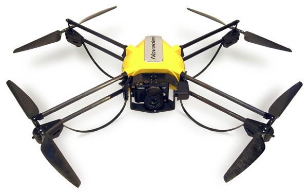


4 Redbird fleet : fixed- and rotary-wings (2 nd UAS acquired) 4


 LIDAR")
5 Redbird sensors Photo / video RGB - visible DT18 3 bands 5-9 Mpx Ricoh Mpx NEX7 24 Mpx Infrared - NIR Multispectral DT18 4 bands 5 MPx Tetracam Mini-MCA 6 Panoptes FLIR TAU2 640 LIDAR (laser) LIDAR Sick LD-MRS (under evaluation) 5
6 Redbird s targeted markets TRANSPORT NETWORKS ELECTRICITY OIL & GAS! Long distance corridor mapping! Predictive maintenance! Security CONSTRUCTION! Inspection of works! Infrastructure standards! Project planning MINES & QUARRIES! Topography site s monitoring! 3D Modelling! Inspection of works! Cartography and topography! Volume calculation! Stock monitoring AGRICULTURE & ENVIRONMENT! Cartography and remote sensing (precision agriculture). Crop dusting. 6

7 Remote sensing of vegetation? TRANSPORT NETWORKS ELECTRICITY OIL & GAS AGRICULTURE & ENVIRONMENT 7

 80 km/h Ricoh calibrated 10MPix Ricoh camera and NIR filter 150m altitude : 150 ha in")
8 The X-100, a suitable tool for agriculture The Gatewing X-100 Launcher Operator Weight Dimensions Autopilot Autonomy Precision Speed Sensor Coverage Operations 2,2 kg 100 cm x 60 cm Automatic take-off and landing. GPS navigation via waypoints. 45 min up to 3.5 cm per px (x,y) 80 km/h Ricoh calibrated 10MPix Ricoh camera and NIR filter 150m altitude : 150 ha in average Excellent resistance to harsh weather conditions (winds) 8
 is reflected even more than green, but not visible to naked eye.")
9 Background: vegetation reflectance & NDVI Plants use (absorb) red and blue wavelengths for photosynthesis -> from visible wavelengths, only green is reflected (= we see plants green) From the entire spectrum, near-infrared (NIR; nm) is reflected even more than green, but not visible to naked eye. More specifically: the difference between reflectance in NIR and red gives a good indication of plant stress, health status, growth. Most widely used index: Normalized Difference Vegetation Index (NDVI) 9

.")
10 Business case : precision analysis of sunflowers field Mission objective: production of NDVI mapping of a 19 hectares sunflowers field into micro-plots for statistical analysis and research purposes (breeding & seed selection). Each plot : 25 m 2 Technology used : TRIMBLE Gatewing X-100 Trimble GeoExplorer 6000 Software used 10


 3,5 cm per px")
 4 Red")
11 Capturing NIR and calculating the NDVI Very high resolution geo-referenced and accurate orthophoto (4 Go) 3,5 cm per px (x,y) 1 2 NIR only 3 RGB (visible) 4 Red only (visible) NDVI 11

 to calculate vegetation")

12 NDVI calculation for every 25 m2 microplot Color channels have been separated in GIS (or remote sensing software) to calculate vegetation index for every plot. We used ArcGis. Mean NDVI per microplot ( ) 12
13 Precision and accuracy : every flower is visible 13
 CCL : the X-100 a relevant tool for the remote sensing of vegetation for agricultural & research")
14 Calculating plant height (i) DSM : Digital surface model (ii) DTM : Digital terrain model (naked soil between the plots) (iii) Measurement of plant s height A good correlation between the UAV-based measures and the measures on the ground (r 2 = 0,79) CCL : the X-100 a relevant tool for the remote sensing of vegetation for agricultural & research purposes 14
 To provide agronomic advice :! Maximize the production!")
!")
15 A wide range of agri/viti applications UAS are an appropriate solution to analyze the cultures at the intra-plot level (cm resolution) To provide agronomic advice :! Maximize the production! Minimize the amount of phytosanitary products used as well as water input! Detect and characterize diseases (including grapewine flavescence dorée)! Organise the harvesting period! Detect weeds 15

16 Remote sensing of vegetation on long distances To detect vegetation around large infrastructure network (railways, power lines, gas pipelines or even invading algae in rivers. Objective : to save costs by detecting automatically and precisely every single area that need to be treated. The UAV-acquired and analyzed data can be easily managed as a new layer in the clients GIS. 16
 and accuracy 2. Quick turnaround times (up to 5-8 flights per day) 3. Lower operation costs (electrical powered UAS) 4.")
 These features are of special interest in precision farming or irrigation scheduling where time-critical management : short revisit time is required high spatial resolution")
17 Benefits of UAS vs. traditional operations The benefits of the Trimble UAS platforms as compared to other airborne / satellite acquisition are : 1. The high spatial resolution (cm) and accuracy 2. Quick turnaround times (up to 5-8 flights per day) 3. Lower operation costs (electrical powered UAS) 4. Operation in all weather conditions (max. wind 65 km/h) These features are of special interest in precision farming or irrigation scheduling where time-critical management : short revisit time is required high spatial resolution is mandatory Agriculture is to become one of the largest markets for UAS on the medium term A new tool to acquire big data, a new field of innovations for dedicated sensors (other indexes that NDVI) and data analysis. 17
18 The UAV market : happening now? 700 (France) +110% over 6 months Companies UAVs +350% over a year nov.-12 déc janv.-13 févr.-13 mars-13 avr.-13 mai-13 juin-13 juil.-13 août-13 sept.-13 oct.-13 nov.-13 déc.-13 janv.-14 févr.-14 mars-14 avr mai registered companies are operating UAVs to UAVs operated in France 18


19 Thank you Feel free to contact us : Emmanuel de Maistre - demaistre@redbird.fr


20 We can fly in *every* scenarios (VLOS, BLOS) S1 S3 max. 25 kg max. 4 kg S2 S4 max. 2 kg max. 2 kg Non-populated & populated areas Non-populated areas only VLOS operations (100 m.) E-VLOS (<1 km) and B-VLOS (> 1km) Applications : Industrial inspections & medias Applications : large areas (topography), long distances (corridor mapping), agriculture


21 Business case 2: industrial monitoring Mission objective: detection of unregistered sites in the vicinity of the network, identification of signal beacons and zones at risk. Data acquisition: two days of data acquisition over 30 km of gas pipeline. Data processing: production of orthophotos and remote sensing of objects. Hardware used DT-18 Software used 21
22 Four requirements to operate RPAS in France! MAP : «Manuel d activités particulières». A document that describes the company RPAS and operating procedures (safety, etc.). 3-4 weeks for approval.! Pilot training / DNC : «Déclaration de niveau de compétence». A document that certifies the training of the pilots themselves. 1-2 weeks of training! Insurance for civil responsibility. Est. 500 euros / year.! Approved RPAS (industrial or DIY)! Specific approval in some cases (city and/or landowner approval) 22
GEOMATICS. Shaping our world. A company of
 GEOMATICS Shaping our world A company of OUR EXPERTISE Geomatics Geomatics plays a mayor role in hydropower, land and water resources, urban development, transport & mobility, renewable energy, and infrastructure
P R O U D LY C A N A D I A N
 P R O U D LY C A N A D I A N 1.855.423.3185 info@rmegeomatics.com AERIAL SURVEYING IMAGING TERRAIN ANALYSIS WHO WE ARE HSE & REGULATORY CLIENT INDUSTRIES RME Geomatics (formerly NGF Geomatics) was founded
Scout Aerial Africa DRONES THE BIG PICTURE FOR GEOLOGY AND MINING
 Scout Aerial Africa DRONES THE BIG PICTURE FOR GEOLOGY AND MINING WHO ARE WE? Scout Aerial Group is a diversified operating and investment group with market leading businesses and targeted investment in
VISUALIZING THE SMART CITY 3D SPATIAL INFRASTRUCTURE GEOSMART ASIA- 30 SEP, 2015
 www.aamgroup.com VISUALIZING THE SMART CITY 3D SPATIAL INFRASTRUCTURE GEOSMART ASIA- 30 SEP, 2015 Agenda AAM What is a Smart City? Data Acquisition 3D Modelling Benefits Questions AAM AAM is a Geospatial
Presented at the FIG Congress 2018, May 6-11, 2018 in Istanbul, Turkey
 Presented at the FIG Congress 2018, May 6-11, 2018 in Istanbul, Turkey GIS Application in Technical and Environmental Safety of Natural Gas Transmission Pipelines, a Case Study Tuncer OZERBIL GEOGIS GIS
Airborne Corridor-Mapping. Planning and documentation of company infrastructure: precise, rapid, and cost effective
 Airborne Corridor-Mapping Planning and documentation of company infrastructure: precise, rapid, and cost effective Technology Airborne Laser-Scanning, digital orthophotos and thermal imaging: one flight
Land Administration and Cadastre
 Geomatics play a major role in hydropower, land and water resources and other infrastructure projects. Lahmeyer International s (LI) worldwide projects require a wide range of approaches to the integration
Technical Drafting, Geographic Information Systems and Computer- Based Cartography
 Technical Drafting, Geographic Information Systems and Computer- Based Cartography Project-Specific and Regional Resource Mapping Services Geographic Information Systems - Spatial Analysis Terrestrial
Case Study microdrones in Geomatics Remote Sensing
 Case Study microdrones in Geomatics Remote Sensing Version 1.0 Presented by: Carlos Espadas (INGECOR Geomática SL) & Michael Thoss (microdrones GmbH) Profiles: microdrones / Ingecor Geomática Contact information
UAV s in Geoinformatics - Trends and Perspectives
 UAV s in Geoinformatics - Trends and Perspectives Torsten Prinz & Christian Knoth Institute for Geoinformatics (IFGI), University of Muenster (WWU) GeoNetzwerk Münsterland (29.11.2013) I. Introduction
The platform is the means, not the end goal
 The platform is the means, not the end goal + Complete analytics platform at an accessible price point Compliments existing workflows by integrating with the new intelligent farm equipment. The goal is
Unmanned Aerial Systems (UAS) Innovation for affordable, improved and accelerated spatial data acquisition
 Innovation for affordable, improved and accelerated spatial data acquisition") Unmanned Aerial Systems (UAS) Innovation for affordable, improved and accelerated spatial data acquisition Kathrine Kelm, The World Bank Rumyana Tonchovska, FAO Walter Volkmann, Micro Aerial Projects,
Unmanned Aerial Systems (UAS) Innovation for affordable, improved and accelerated spatial data acquisition Kathrine Kelm, The World Bank Rumyana Tonchovska, FAO Walter Volkmann, Micro Aerial Projects,
QuestUAV British UAV Manufacturer
 QuestUAV British UAV Manufacturer Aircraft designed to carry sensors such as high resolution cameras infra red cameras thermal and video cameras multiple payloads QuestUAV have been operating for five
GIS and Remote Sensing
 Spring School Land use and the vulnerability of socio-ecosystems to climate change: remote sensing and modelling techniques GIS and Remote Sensing Katerina Tzavella Project Researcher PhD candidate Technology
Remote Sensing Techniques for Renewable Energy Projects. Dr Stuart Clough APEM Ltd
 Remote Sensing Techniques for Renewable Energy Projects Dr Stuart Clough APEM Ltd What is Remote Sensing? The use of aerial sensors to detect and classify objects on Earth Remote sensing for ecological
UAV APPLICATIONS IN ENGINEERING. Presented By Wohnrade Civil Engineers, Inc.
 UAV APPLICATIONS IN ENGINEERING Presented By Wohnrade Civil Engineers, Inc. UAV BUSINESS STARTUP March 31, 2015 - Obtained DJI Inspire 1 Unmanned Aerial Vehicle (UAV) FAA requires Certificate of Authorization
Emergency Planning. for the. Democratic National. Convention. imaging notes // Spring 2009 //
 Emergency Planning for the Democratic National Convention The DRAPP Demonstrates Partnership among Local, Regional, State, Utility and Federal Governments 14 imaging notes // Spring 2009 // www.imagingnotes.com
Weather Needs for UAS Operations
 Minneapolis - Denver - Washington, D.C. Weather Needs for UAS Operations Brian Haynes - President November 2016 1 Sensurion Background: 10-year company history UAS Weather Needs Sensurion Perspective Extensive
Imagery and the Location-enabled Platform in State and Local Government
 Imagery and the Location-enabled Platform in State and Local Government Fred Limp, Director, CAST Jim Farley, Vice President, Leica Geosystems Oracle Spatial Users Group Denver, March 10, 2005 TM TM Discussion
GIS Workshop Data Collection Techniques
 GIS Workshop Data Collection Techniques NOFNEC Conference 2016 Presented by: Matawa First Nations Management Jennifer Duncan and Charlene Wagenaar, Geomatics Technicians, Four Rivers Department QA #: FRG
XXIII CONGRESS OF ISPRS RESOLUTIONS
 XXIII CONGRESS OF ISPRS RESOLUTIONS General Resolutions Resolution 0: Thanks to the Czech Society commends: To congratulate The Czech Society, its president and the Congress Director Lena Halounová, the
Flood Mapping Michael Durnin October 9 th
 Michael Durnin October 9 th 2014 Leading Surveyors Company Profile Est. 1983 Celebrating 30 Years in Business Six Offices in UK & Ireland Over 30 Specialised Survey Services ISO 9001:2008 Registered Over
Airborne Multi-Spectral Minefield Survey
 Dirk-Jan de Lange, Eric den Breejen TNO Defence, Security and Safety Oude Waalsdorperweg 63 PO BOX 96864 2509 JG The Hague THE NETHERLANDS Phone +31 70 3740857 delange@fel.tno.nl ABSTRACT The availability
Yrd. Doç. Dr. Saygın ABDİKAN Öğretim Yılı Güz Dönemi
 Yabancı Dil III (YDL285) Introduction to Geomatics Yrd. Doç. Dr. Saygın ABDİKAN 2017-2018 Öğretim Yılı Güz Dönemi 1 géomatique Geo (Earth) + informatics Geodesy + Geoinformatics Geomatics: The mathematics
STEREO ANALYST FOR ERDAS IMAGINE Stereo Feature Collection for the GIS Professional
 STEREO ANALYST FOR ERDAS IMAGINE Stereo Feature Collection for the GIS Professional STEREO ANALYST FOR ERDAS IMAGINE Has Your GIS Gone Flat? Hexagon Geospatial takes three-dimensional geographic imaging
GIS = Geographic Information Systems;
 What is GIS GIS = Geographic Information Systems; What Information are we talking about? Information about anything that has a place (e.g. locations of features, address of people) on Earth s surface,
GIS Application in Technical and Environmental Safety of Natural Gas Transmission Pipelines, a Case Study
 GIS Application in Technical and Environmental Safety of Natural Gas Transmission Pipelines, a Case Study Tuncer OZERBIL, Engin PEKEL, Dilvin Ceneli TUGRUL, Cihan SEZGIN and Osman SELCUK, Turkey Key words:
Aerial Survey of Coffee Estates
 Aerial Survey of Coffee Estates Why get an Aerial Survey of your Coffee Estate done? Aerial surveying produces high resolution and highly accurate image data about your coffee estate. This data can be
AERIAL DATA SERVICES
 AERIAL DATA SERVICES f o r I N D U S T R I A L A P P L I C AT I O N S C O N S T R U C T I O N * A G R I C U L T U R E * E N E R G Y * E N V I R O N M E N T A L A e r o L o g i x C o n s u l t i n g I n
Ramani Geosystems. Putting Africa On The Map. Authorized Resellers
 Ramani Geosystems Putting Africa On The Map Authorized Resellers Ramani Profile Started in 1999 Aerial, Land Surveying & Mapping Solutions + 10 Countries in the region + 80 Staff working in projects Asset
DMS-UAV Accuracy Assessment: AP20 with Nikon D800E
 DMS-UAV Accuracy Assessment: AP20 with Nikon D800E Joe Hutton, Greg Lipa, James Lutes, Omer Mian Applanix, William Chan - GeoPixel Air Introduction The Direct Mapping Solution for Unmanned Aerial Vehicles
MULTICHANNEL NADIR SPECTROMETER FOR THEMATICALLY ORIENTED REMOTE SENSING INVESTIGATIONS
 S E S 2 5 Scientific Conference SPACE, ECOLOGY, SAFETY with International Participation 1 13 June 25, Varna, Bulgaria MULTICHANNEL NADIR SPECTROMETER FOR THEMATICALLY ORIENTED REMOTE SENSING INVESTIGATIONS
A Broad View of Geospatial Technology & Systems
 A Broad View of Geospatial Technology & Systems Pete Large Vice President, Trimble On the shoulders of giants 1 Since their time, our ability to generate geospatial information has grown exponentially
REVIEW MAPWORK EXAM QUESTIONS 31 JULY 2014
 REVIEW MAPWORK EXAM QUESTIONS 31 JULY 2014 Lesson Description In this lesson we: Focus on key concepts and exam questions relating to GIS. Question 1 Test Yourself The most important component of a GIS
FROM WATER LEAKS TO WINE GRAPES: A NEW OUTLOOK FOR IMAGERY ANALYSIS
 Place image here (10 x 3.5 ) FROM WATER LEAKS TO WINE GRAPES: A NEW OUTLOOK FOR IMAGERY ANALYSIS ENVI AS A FRAMEWORK FOR CLOUD SERVICES & DEEP LEARNING Presented By Gordon Sumerling on Behalf of Cherie
Excel Geomatics: Offering Excellence with Unique Consultancy & Services
 Excel Geomatics: Offering Excellence with Unique Consultancy & Services Providing consultancy and value Added Services using Remote Sensing, Photogrammetry and LiDAR in areas such as Agriculture, Forestry,
Geospatial capabilities, spatial data and services provided by Military Geographic Service
 Geospatial capabilities, spatial data and services provided by Military Geographic Service LtC Mariyan Markov PhD CONTENTS 1. INTRODUCTION - Workflow - Data sources remote sensing, direct field observation.
1994: JV formed for civil engineering consultancy COWI/KX A/s, Denmark(51%) IFU, Denmark (24% ) IL&FS Infrastructure Dev Corp, India(25%)
 IFU, Denmark (24% ) IL&FS Infrastructure Dev Corp, India(25%)") Company Profile 1994: JV formed for civil engineering consultancy COWI/KX A/s, Denmark(51%) IFU, Denmark (24% ) IL&FS Infrastructure Dev Corp, India(25%) 1998: Start of mapping as a new segment of Business.
Company Profile 1994: JV formed for civil engineering consultancy COWI/KX A/s, Denmark(51%) IFU, Denmark (24% ) IL&FS Infrastructure Dev Corp, India(25%) 1998: Start of mapping as a new segment of Business.
Earth Observation Satellites Dawn of Application Specific Satellite Data. Date: 26 July 2017
 Earth Observation Satellites Dawn of Application Specific Satellite Data Date: 26 July 2017 Introducing a World of New Possibilities Satellite imagery is a critical fountain of information on al levels
Fundamentals of Remote Sensing
 Division of Spatial Information Science Graduate School Life and Environment Sciences University of Tsukuba Fundamentals of Remote Sensing Prof. Dr. Yuji Murayama Surantha Dassanayake 10/6/2010 1 Fundamentals
THE USE OF GEOMATICS IN CULTURAL HERITAGE AND ARCHAEOLOGY FOR VARIOUS PURPOSES
 THE USE OF GEOMATICS IN CULTURAL HERITAGE AND ARCHAEOLOGY FOR VARIOUS PURPOSES FEBRUARY 2013 AL BEIDA GEOPLAN CONTENT Company Profile Concept Objectives and Strategies Data Production Methods Data Samples
An Unmanned Aerial Vehicle-based Radiation Surveillance System. Seungwoo Lee Korea Electronics Technology Institute
 An Unmanned Aerial Vehicle-based Radiation Surveillance System Seungwoo Lee Korea Electronics Technology Institute The Research on Radiation Dispersion Prevention Systems All the Physical Barriers and
Using Remote Piloted Aircraft for Seawall Condition Assessment
 Using Remote Piloted Aircraft for Seawall Condition Assessment Moreton Bay Regional Council Shamim Yazdani Senior Engineer - Stormwater Planning DJI Industries Phantom FC-40 remotely-piloted aircraft 1
CENSUS MAPPING WITH GIS IN NAMIBIA. BY Mrs. Ottilie Mwazi Central Bureau of Statistics Tel: October 2007
 CENSUS MAPPING WITH GIS IN NAMIBIA BY Mrs. Ottilie Mwazi Central Bureau of Statistics E-mail: omwazi@npc.gov.na Tel: + 264 61 283 4060 October 2007 Content of Presentation HISTORICAL BACKGROUND OF CENSUS
Building a National Data Repository
 Building a National Data Repository Mladen Stojic, Vice President - Geospatial 1/30/2013 2012 Intergraph Corporation 1 Information has meaning and gives power only when shared and distributed. Information,
An Introduction of Unmanned Aerial Systems (UAS) for Weather Operations
 for Weather Operations") An Introduction of Unmanned Aerial Systems (UAS) for Weather Operations Chotipong Chamchalaem Graduate Seminar Spring 2017 Cal Poly San Luis Obispo Motivation Interest in exploring new applications for
An Introduction of Unmanned Aerial Systems (UAS) for Weather Operations Chotipong Chamchalaem Graduate Seminar Spring 2017 Cal Poly San Luis Obispo Motivation Interest in exploring new applications for
USING LIDAR MEASUREMENTS FOR IMPROVING OR UP-DATING A DEM
 JAES_1(14)_3_2011 VAIS M. et. all, pp.123-128 SECTION Geodesic Engineering USING LIDAR MEASUREMENTS FOR IMPROVING OR UP-DATING A DEM VAIS Manuel*, IOSIF Gheorghe, Bucharest University, *e-mail: manuel.vais@sipg.ro
UAS Applications Tim McCarthy, NUI Maynooth INFOMAR 9 th Oct
 UAS Applications Tim McCarthy, NUI Maynooth INFOMAR 9 th Oct 2013 1 About Us National Centre for Geocomputation (NCG) Established in 2004 with an SFI PI Grant 4 X PIs coordinate various research projects
Sustainable and Harmonised Development for Smart Cities The Role of Geospatial Reference Data. Peter Creuzer
 Sustainable and Harmonised Development for Smart Cities The Role of Geospatial Reference Data Peter Creuzer 1. Introduction - Smart Cities and Geodata 2. Geodata in Germany 3. Examples 4. Data and Service
IPL Project (IPL - 196) Annual Report Form 2017
 Annual Report Form 2017") Date of Submission 26/03/2017 IPL Project (IPL - 196) Annual Report Form 2017 1 January 2016 to 31 December 2016 1. Project Number (approved year) and Title, IPL-196 (2015) Development and applications
Date of Submission 26/03/2017 IPL Project (IPL - 196) Annual Report Form 2017 1 January 2016 to 31 December 2016 1. Project Number (approved year) and Title, IPL-196 (2015) Development and applications
Innovation in mapping and photogrammetry at the Survey of Israel
 16, October, 2017 Innovation in mapping and photogrammetry at the Survey of Israel Yaron Felus and Ronen Regev Contents Why HD mapping? Government requirements Mapping regulations o Quality requirements
Japan Construction Information Center
 Japan Construction Information Center A Framework for Data Coordination Method of Maintenance Data and 3D Conceptual Model on CIM Based Database July 2016 Japan Construction Information Center Foundation
Spanish national plan for land observation: new collaborative production system in Europe
 ADVANCE UNEDITED VERSION UNITED NATIONS E/CONF.103/5/Add.1 Economic and Social Affairs 9 July 2013 Tenth United Nations Regional Cartographic Conference for the Americas New York, 19-23, August 2013 Item
Themes for Geomatics Conference. Geodesy Themes
 Themes for Geomatics Conference Geodesy Themes Geodynamics o Modeling the Deformation of the Earth s Crust o Recent Advances in Geometric Approaches to Deformation Analysis o Monitoring Systems (Sensors
GEOMATICS SURVEYING AND MAPPING EXPERTS FOR OVER 35 YEARS
 GEOMATICS SURVEYING AND MAPPING EXPERTS FOR OVER 35 YEARS 2 GEOMATICS AND SURVEYING SOLUTIONS SPANNING THE ENTIRE PROJECT LIFECYCLE 1,000+ 250+ 24 Surveying professionals Active field crews Geomatics offices
Geospatial Technologies
 An Overview of Prepared by: John McGee Jennifer McKee With support from: NSF DUE-0903270 in partnership with: Geospatial Technician Education Through Virginia s Community Colleges (GTEVCC) What is Geospatial?
Chapter 5 LiDAR Survey and Analysis in
 Chapter 5 LiDAR Survey and Analysis in 2010-2011 Christopher Fennell A surveyor s plat and town plan filed in 1836 set out an intended grid of blocks, lots, alleys, and streets for New Philadelphia. Geophysical,
Remote detection of giant reed invasions in riparian habitats: challenges and opportunities for management planning
 Remote detection of giant reed invasions in riparian habitats: challenges and opportunities for management planning Maria do Rosário Pereira Fernandes Forest Research Centre, University of Lisbon Number
New LPIS data and their quality control in Macedonia. Pavel TROJACEK & Adam ZLOTY EKOTOXA s.r.o.
 New LPIS data and their quality control 15th GeoCAP Conference, Taormina, Italy 18 20 November 2009 Outline of the presentation Intro: About Macedonia 1. Design of LPIS 2. LPIS methodology 3. New spatial
Current Research Trends from an Australian Perspective. Dr Philip Collier Research Director
 Current Research Trends from an Australian Perspective Dr Philip Collier Research Director Growth in the spatial sector. 11% pa in the Global Navigation Satellite System market 2010-2020 300% growth in
Part : General Situation of Surveying and Mapping. The Development of Surveying and Mapping in China. The contents
 The Development of Surveying and Mapping in China Dr. Ping Xiao China.P.R The contents Part : General Situation of Surveying and Mapping 1. The legal systems of surveying and mapping 2. The technologies
2 nd Japan and Republic of Korea LiDAR Survey Symposium
 2 nd Japan and Republic of Korea LiDAR Survey Symposium 2010 年 9 月 20 日 Prof. Woosug Cho wcho@inha.ac.kr Spacematics Lab Department of Civil Engineering Inha University Presentation on Current Status in
T: E:
 PAS 128 UTILITY DETECTION AND MAPPING TOPOGRAPHICAL SURVEYS UTILITY RECORD SEARCHES AND DESK TOP STUDY SURFACE WATER DRAINAGE SURVEYS GROUND CLEARANCE SURVEYS MEASURED BUILDING SURVEYS LASER SCANNING UAV
Emergency situations. Large industrial objects. Town planning. Use of oblique images
 Use of oblique images Emergency situations Damage estimation fire, flood, inundation, storm, landslide, big accidents, act of terror etc. Management in emergency situation - EMERCOM (Emergency Control
GEOGRAPHY (GE) Courses of Instruction
 Courses of Instruction") GEOGRAPHY (GE) GE 102. (3) World Regional Geography. The geographic method of inquiry is used to examine, describe, explain, and analyze the human and physical environments of the major regions of the
GEOGRAPHY (GE) GE 102. (3) World Regional Geography. The geographic method of inquiry is used to examine, describe, explain, and analyze the human and physical environments of the major regions of the
Remote Sensing Geographic Information Systems Global Positioning Systems
 Remote Sensing Geographic Information Systems Global Positioning Systems Assessing Seasonal Vegetation Response to Drought Lei Ji Department of Geography University of Nebraska-Lincoln AVHRR-NDVI: July
Cutting Edge Engineering for Modern Geospatial Systems Rear Admiral Dr. S Kulshrestha, retd
 Cutting Edge Engineering for Modern Geospatial Systems Rear Admiral Dr. S Kulshrestha, retd 11 Jun 2015 GeoIntelligence Asia 2015 The technology would become so pervasive that it becomes a part of you
Google Maps and Beyond
 Google Maps and Beyond Aaron Paul First American Title apaul@firstam.com 2015 APRA Symposium Association of Professional Reserve Analysts May 2 nd, 2015 Google Maps and Beyond - Overview Business case
Pipeline Integrity Monitoring
 A Global Communications and Information Company Pipeline Integrity Monitoring is subject to the restrictions on the title page of this document. COPYRIGHT 2014 MDA 1 1 Corporate Overview Business Space-based
BUILDING AN ASSET MANAGEMENT GEODATABASE FOR RANCHING. Matt Crawford, GISP
 BUILDING AN ASSET MANAGEMENT GEODATABASE FOR RANCHING Matt Crawford, GISP Introduction East Foundation Formed in 2007 Mission Research Education Outreach Properties Six ranches ~ 215,000 acres San Antonio
Geospatial SDI Portal for effective Governance of Pune METROPOLIS region
 Geospatial SDI Portal for effective Governance of Pune METROPOLIS region Mr. Praveen Gautam Senior Manager 19 th January 2018 PMRDA Overview Provide a Spatial Framework for the entire region with various
What is GIS? Introduction to data. Introduction to data modeling
 What is GIS? Introduction to data Introduction to data modeling 2 A GIS is similar, layering mapped information in a computer to help us view our world as a system A Geographic Information System is a
A Global Approach to Building a GIS Strategy Esri UC July 15th, 2014
 Scott Sitzman and Paloma Urbano A Global Approach to Building a GIS Strategy Esri UC July 15th, 2014 1 METHODOLOGY 2 GIS Strategy Study Methodology Maturity Model by Carnegie Mellon Current State Review
ENVIRONMENT AND NATURAL RESOURCES 3700 Introduction to Spatial Information for Environment and Natural Resources. (2 Credit Hours) Semester Syllabus
 Semester Syllabus") ENVIRONMENT AND NATURAL RESOURCES 3700 Introduction to Spatial Information for Environment and Natural Resources COURSE INSTRUCTOR: Dr. Kris Jaeger Assistant Professor 359 Kottman Hall (Mondays and Tuesdays)
ENVIRONMENT AND NATURAL RESOURCES 3700 Introduction to Spatial Information for Environment and Natural Resources COURSE INSTRUCTOR: Dr. Kris Jaeger Assistant Professor 359 Kottman Hall (Mondays and Tuesdays)
Excel Geomatics. Rajesh Paul Excel Geomatics Pvt. Ltd., Noida February, 2015 India Geospatial Forum, Hyderabad
 Excel Geomatics Geo-marketing for Product Sales and Customer Services Rajesh Paul Excel Geomatics Pvt. Ltd., Noida 10-12 February, 2015 India Geospatial Forum, Hyderabad Presentation Outline About Excel
CLICK HERE TO KNOW MORE
 CLICK HERE TO KNOW MORE GENERALIZATION OF TOPOGRAPHIC DATABASE FOR SERVING GEOSPATIAL DATA FOR MILITARY AND SOCIO-ECONOMIC TASKS IN VIETNAM Speaker: Lieutenant Colonel, Nguyen Dinh Minh GENERAL STAFF -
Industry Trends and Direction: a quick look! John Whitehead Trimble Navigation Ltd.
 Industry Trends and Direction: a quick look! John Whitehead Trimble Navigation Ltd. Converging forces have placed geospatial information at the center of an evolving ecosystem Technology Societal Forces
CARTOGRAPHIC INFORMATION MANAGEMENT IN COLOMBIA REACH A LEVEL OF PERFECTION
 CARTOGRAPHIC INFORMATION MANAGEMENT IN COLOMBIA REACH A LEVEL OF PERFECTION Jaime Alberto Duarte Castro 1 Carrera 30 No. 48 51 Bogotá - Colombia, jduarte@igac.gov.co Claudia Inés Sepúlveda Fajardo 2 Carrera
About Nnergix +2, More than 2,5 GW forecasted. Forecasting in 5 countries. 4 predictive technologies. More than power facilities
 About Nnergix +2,5 5 4 +20.000 More than 2,5 GW forecasted Forecasting in 5 countries 4 predictive technologies More than 20.000 power facilities Nnergix s Timeline 2012 First Solar Photovoltaic energy
The advantages of the services on the web-gis:
 The advantages of the services on the web-gis: Availability - Get access to the system can be in any place and at any time, it is enough to have at his workplace Internet access. Easy - Work in an ordinary
Techniques for Science Teachers: Using GIS in Science Classrooms.
 Techniques for Science Teachers: Using GIS in Science Classrooms. After ESRI, 2008 GIS A Geographic Information System A collection of computer hardware, software, and geographic data used together for
Urban Tree Canopy Assessment Purcellville, Virginia
 GLOBAL ECOSYSTEM CENTER www.systemecology.org Urban Tree Canopy Assessment Purcellville, Virginia Table of Contents 1. Project Background 2. Project Goal 3. Assessment Procedure 4. Economic Benefits 5.
Exploit your geodata to enable smart cities and countries
 Exploit your geodata to enable smart cities and countries Carsten Rönsdorf, Head of Advisory Services Middle East Practice Manager Future Cities, standards and 3D 24 November 2014 Importance of Standards
State of Israel Ministry of Housing and Construction Survey of Israel. The Hydrological project case
 State of Israel Ministry of Housing and Construction Survey of Israel The Hydrological project case Survey of Israel Content Introduction To the Survey of Israel The operation assumptions The main responsibilities
Lesson 4b Remote Sensing and geospatial analysis to integrate observations over larger scales
 Lesson 4b Remote Sensing and geospatial analysis to integrate observations over larger scales We have discussed static sensors, human-based (participatory) sensing, and mobile sensing Remote sensing: Satellite
The Use of Higher-Resolution Satellite Imagery, LiDAR and Drones in River Applications:
 The Use of Higher-Resolution Satellite Imagery, LiDAR and Drones in River Applications: Meander Belt Width Assessments to Effluent Plume Delineation Joanna Eyquem, P.Geo., Principal Fluvial Geomorphology,
History & Scope of Remote Sensing FOUNDATIONS
 History & Scope of Remote Sensing FOUNDATIONS Lecture Overview Introduction Overview of visual information Power of imagery Definition What is remote sensing? Definition standard for class History of Remote
Statewide Topographic Mapping Program
 Statewide Topographic Mapping Program February 28, 2018 www.dotd.la.gov Outline Purpose of the Statewide Topographic Mapping Program History Breakdown of R.S. 48:36 - Topographic Mapping Statewide Topographic
Enhance Security, Safety and Efficiency With Geospatial Visualization
 Areas within 10 minutes of an exit are emphasized on this map, to give an indication of how accessible neighborhoods are by highway. The colors represent 1, 3, 5 and 10 minute increments from the exits.
Trimble s ecognition Product Suite
 Trimble s ecognition Product Suite Dr. Waldemar Krebs October 2010 Trimble Geospatial in the Image Processing Chain Data Acquisition Pre-processing Manual/Pixel-based Object-/contextbased Interpretation
Introduction to GIS. Dr. M.S. Ganesh Prasad
 Introduction to GIS Dr. M.S. Ganesh Prasad Department of Civil Engineering The National Institute of Engineering, MYSORE ganeshprasad.nie@gmail.com 9449153758 Geographic Information System (GIS) Information
Syllabus Reminders. Geographic Information Systems. Components of GIS. Lecture 1 Outline. Lecture 1 Introduction to Geographic Information Systems
 Syllabus Reminders Geographic Information s Lecture Introduction to Geographic Information s. Class Info: www.saigis.com/class/ 2. Office T / TH (8:00-9:30 a.m.) and (2:30 3:30pm) or Appt 3. Email: burgerpr@unk.edu
GENERATION OF 3D CITY MODELS FROM TERRESTRIAL LASER SCANNING AND AERIAL PHOTOGRAPHY: A CASE STUDY
 GENERATION OF 3D CITY MODELS FROM TERRESTRIAL LASER SCANNING AND AERIAL PHOTOGRAPHY: A CASE STUDY Hakan KARABORK 1, Fatih SARI 1 1 Selcuk University in Konya, Faculty of Engineering and Architecture Konya,
SOLUTIONS ADVANCED GIS. TekMindz are developing innovative solutions that integrate geographic information with niche business applications.
 ADVANCED GIS SOLUTIONS TekMindz are developing innovative solutions that integrate geographic information with niche business applications. TEK INDZ TM GIS Services Overview At the leading edge of geospatial
ESRI GIS For Mining Seminar, 10 th August, 2016, Nairobi, Kenya. Spatial DATA Solutions for Mining
 ESRI GIS For Mining Seminar, 10 th August, 2016, Nairobi, Kenya Spatial DATA Solutions for Mining Spatial Data Solutions for Mining Spatial - Data that identifies the geographic location of features &
Navy League Sea-Air-Space Expo 2013
 Navy League Sea-Air-Space Expo 2013 Decision-making superiority delivered. All rights reserved. Insitu is a Boeing Company. 1 Insitu Snapshot Leading provider of Small Long-Endurance Unmanned Aircraft
sentinel-2 COLOUR VISION FOR COPERNICUS
 sentinel-2 COLOUR VISION FOR COPERNICUS SATELLITES TO SERVE By providing a set of key information services for a wide range of practical applications, Europe s Copernicus programme is providing a step
Geographic information for Strasbourg : from historical land register to 3D GIS city modelling 09/07/2017
 Geographic information for Strasbourg : from historical land register to 3D GIS city modelling 09/07/2017 Table of contents 1. Introduction of Strasbourg 2. A century of land surveying and cadastre 3.
GIS FOR MAZOWSZE REGION - GENERAL OUTLINE
 GIS FOR MAZOWSZE REGION - GENERAL OUTLINE S. Bialousz 1), K Mączewski 2), E. Janczar 2), K. Osinska-Skotak 1) 1) Warsaw University of Technology, Warsaw, Poland 2) Office of the Surveyor of the Mazowieckie
Regional Centre for Mapping of Resources for Development (RCMRD), Nairobi, Kenya. Introduction GIS (2 weeks: 10 days)
, Nairobi, Kenya. Introduction GIS (2 weeks: 10 days)") Regional Centre for Mapping of Resources for Development (RCMRD), Nairobi, Kenya Introduction GIS (: 10 days) Intake Dates: 9 th Jan, 6 th Feb, 6 th Mar, 3 rd April, 8 th May, 5 th June, 3 rd July, 2017
Regional Centre for Mapping of Resources for Development (RCMRD), Nairobi, Kenya Introduction GIS (: 10 days) Intake Dates: 9 th Jan, 6 th Feb, 6 th Mar, 3 rd April, 8 th May, 5 th June, 3 rd July, 2017